Submitted:
29 May 2023
Posted:
30 May 2023
You are already at the latest version
Abstract
The relocation of the Indonesian capital from Jakarta to Ibu Kota Nusantara (IKN) East Kalimantan IKN will affect several sectors. The change in land use from vegetated to developed land will lead to local climate changes, including the emergence of the urban heat island (UHI) phenomenon, which is reflected in a higher land surface temperature (LST) than the surrounding area. In this study, an analysis of UHI propagation was conducted on a seasonal (DJF, MAM, JJA, and SON), with 5 yearly periods from 2001 to 2020, study area in IKN and its buffer cities (Balikpapan, Samarinda, and Bontang). Terra-MODIS satellite data are processed using Google Earth Engine (GEE) platform and output is done using GrADS. UHI (high LST) is found in urban areas/buffer cities both spatially and temporally in every season, while UHI has not yet occurred in IKN (low LST) and suburban, rural, hilly areas, vegetated areas, and water bodies (lakes, rivers). The cross-sectional latitudinal and longitudinal analysis showed that the LST DJF2015-2020 from highest to lowest temperature are in Balikpapan City (36.84 OC), Samarinda City (36.13 OC), Bontang City (32.3 OC); and IKN zero point (28.82 OC). The UHI propagation was observed in 2001-2005, 2006-2010, 2011-2015, and most during 2016-2020. Seasonally, the UHI was most pronounced in the SON season, while on lowest UHI was observed in the MAM season.
Keywords:
Ibu Kota Nusantara (IKN)
; urban heat island (UHI)
; land surface temperature (LST)
; seasonal
; Terra-MODIS
; Google Earth Engine (GEE)
; buffer cities
1. Introduction
The Indonesian government plans to relocate the Indonesian capital from Jakarta to Ibu Kota Nusantara (IKN) in Penajam Paser Utara (PPU) East Kalimantan starting in 2024. The urgency of relocating the capital is due to the objective condition of Jakarta which is no longer suitable as the capital. This is evident from "burden" Jakarta has to bear: 1) a population density of 16,704 people/km², while Indonesia's population density is only 141 people/km²; 2) the traffic congestion of Jakarta, which is the number 10 most congested city in the world in 2019, although in 2020 it is only 31st out of 416 major cities in 57 countries (TomTom Traffic Index); 3) acute environmental and geological problems such as flooding that afflicts Jakarta every year and land subsidence that causes parts of Jakarta to be below sea level [1]. The location of the IKN is also said to be ideal because it is close to developed urban areas as buffer cities, namely Balikpapan, Samarinda, and Bontang. The IKN is also a national identity that is a benchmark for a smart, green, beautiful, and modern sustainable capital city with international standards.
The relocation of the capital will certainly entail massive construction works that will affect several sectors. This will greatly change the natural conditions in the surrounding area, affecting climate change and the environment. A strategic intervention program that can respond to the challenges of IKN development is the concept of Forest City and Climate Plus Village (Proklim+). To support the concept of IKN becoming a smart metropolis that guarantees the highest quality of life for its inhabitants, climate and environmental conditions must be maintained.
Anthropogenic activities (land use and land cover change/LULC) alter the surface radiation balance so that surface temperature increases. This is known as the urban heat island (UHI) phenomenon [2,3]. UHI is a phenomenon in which urban areas have higher temperatures than suburban and rural areas. The high land surface temperature (LST) in urban areas is a manifestation of UHI, which gradually decreases in vegetated rural areas [4,5,6]. The modification of LU by adding urban in vegetation areas using Weather Research Forecasting (WRF) will increase air temperature in Jakarta and IKN [7,8].
Research on UHI and land cover using Google Earth Engine (GEE) has been studied by remote sensing experts [9,10,11,12,13]. GEE is a platform that is a powerful application for using big data because it does not require local storage of imagery, but allows the analysis of the satellite imagery in cloud-based processing.
2. Materials and Methods
2.1. Study Area
The location of the study area is centered on the future IKN and the surrounding area as a buffer city is located between latitudes 1.56°S – 0.26°N and longitudes 115.6°E – 117.8°E (Figure 1). The IKN is located in Samboja and Sepaku districts, North Penajam Paser Regency (PPU), East Kalimantan province with a total area of 2560 km2 which is four times larger than Jakarta (661.5 km2). There are four buffer cities for IKN, namely Bontang, Samarinda, Balikpapan, and Tenggarong. Samarinda, the capital of East Kalimantan will be the "heart" as the historical center of East Kalimantan in the renewable energy sector. Balikpapan, on the other hand, is the "muscle", that will act as the downstream oil and gas hub and logistics center for East Kalimantan. The site where the IKN will be built is currently planted with Acacia mangium and Eucalyptus sp. Which are used to produce paper raw materials.
East Kalimantan is located at an elevation of 0-6, 4.49 m above sea level, and has a tropical rainforest climate (Af classification according to Kopen and Geiger). East Kalimantan has an annual high temperature of 30.46 °C and an annual low temperature of 25.11 °C, the warmest month in October (30.96 °C) and the coldest month in July (24.79 °C), an average annual rainfall of 97.22 mm, and a humidity of 78.32% [14,15,16,17].
2.2. Data
This study uses the Terra Moderate Resolution Imaging Spectroradiometer (MODIS) LST and Emissivity daily (MOD11A1) version 6.1. This product provides daily LST per pixel with a spatial resolution of 1 km in a 1.200 by 1.200 km grid. The MOD11 Level 2 swath product derives the pixels LST [18].
LST Level 3 Daily is a daily LST product represented in an integrated sinusoidal projection (in V3) or sinusoidal projection (in V4). The MYD11A1 LST daily product is created from the MOD11_L2 product yields per day using scientific datasets (SDS), mapping all MOD11L2 product pixels to the grid/pixel in a sinusoidal or generated sinusoidal projection and averaging the values in each grid [19,20]. The data trimmed by the MODIS sensors cover the study area at latitude 1.56°S to 0.26°N and longitude 115.6°E to 117.8°E. The data consists of 354 columns x 138 rows (note: only 210 pixels in the 138th row) corresponding to a total area of 48,708 pixels (km2) consisting of 36,435 km2 of land and 12,273 km2 of sea, the elevation following topography. The data period is from 1 January 2001 until 31 December 2020. The data format is HDF Network Common Data Form [21].
2.3. Methods
Processing MODIS data using Javascript in Google Earth Engine (GEE) platform. GEE is a cloud platform with huge data collections of remote sensing satellite imagery and geospatial data, where the process of remote sensing imagery acquisition and data processing is performed online using Javascript syntax language. Cloud computing at GEE enables faster and easier data acquisition and processing. Remote sensing image data is "called" according to the study area, processed as needed, and the processing results can be downloaded for further analysis, with a much smaller amount of data compared to conventional processing. The capability of GEE is very important at this time, especially for rapid data analysis and monitoring.
In this study, UHI was monitored based on seasonality, in December, January, February (DJF), March, April, May (MAM), June, July, August (JJA), and September, October, November (SON). Seasonal data were set as input data in GEE. The data were calculated for a 5-year average, namely, the average of 2001-2005, 2006-2010, 2011-2015, and 2016-2020, resulting in 16 files in GeoTIFF format. Figure 2 shows an example of the Javascript syntax for data processing in GEE in the period DJF 2001-2005.
In Figure 2 "Geometry 2" is the trimmed study area boundary, "Filter data" is the period from 1 January 2001 to 31 December 2005, and "calendar range" is month 12 (December) to 2 (February). When this syntax is executed, it will produce an output file named LSTDJF01-05 generated in GeoTIFF format. For other running periods and seasons, replace "filter date", "calendarRange", "dataset", and "description" according to the desired period and season.
The output of the running data from GEE (GeoTIFF format) is converted to Network Common Data Form (NetCDF or nc) format using QGIS software. NetCDF is a software library that set data and machine-independent data formats that support access, creation, and sharing of array-oriented scientific data [18]. QGIS is a freely available software and open-source application for cross-platform desktop geographic information systems (GIS) that supports editing, viewing, printing, and analyzing of geospatial data. The post-processing output data GEE runs (NetCDF data format) use Grids Analysis Display System (GrADS) (GrADS). GrADS is an easy-to-use, interactive desktop tool that is freely distributed and used to manipulate and visualize geoscience data [22].
3. Results
3.1. LST Seasonal Spatially analysis
3.1.1. LST Seasonal Spatially analysis
UHI propagation was observed through visualization of the output data spatially as shown in Figure 3. Seasonal LST DJF 2001-2005 is shown in Figure 3 (a), then LST DJF 2006-2006 in Figure (b) DJF 2006-2010, (c) DJF 2011-2015, (d) DJF 2016-2020, (e) MAM 2001-2005), (f) MAM 2006-2010, (g) MAM 2011-2015, (h) MAM 2016-2020, (i) JJA 2001-2005, (j) JJA 2006-2010, (k) JJA 2011-2015, (l) JJA 2016-2020, (m) SON 2001-2005, (n) SON 2006-2010), (o) SON 2011-2015, and (p) SON 2016-2020. Purple to red colors in the legend represent LST from low (≤22 OC) to high ((≥32 OC).
In Figure 3(a) (DJF 2001-2005), it can be seen that the areas of high temperature (≥32 OC) in urban areas shown in red, namely Bontang City (purple circle), Samarinda City (black circle), Tenggarong City (green circle), and Balikpapan City (blue circle). This high temperature reflects the occurrence of UHI. While the blue color (at LST around 22 – 25 OC) is found in suburban, rural, hilly/vegetated areas (including areas designed as IKN/red circle) and water bodies (rivers and lakes). High-temperature areas (UHI) are increasingly spreading, as shown in Figure 3(b) (DJF 2006-2010), Figure 3(c) (DJF 2011-2015), and Figure 3(d) (DJF 2015-2020). The next season is MAM, Figure 3(e) MAM 2001-2006 shows UHI in urban areas similar to the pattern in Figure 3(a) DJF 2001-2006, also Figure 3(f) is similar to Figure 3(b), 3 (g) is similar to 3(c), and 3(h) is similar to 3(d). The widest UHI occurred in 2015-2020, for both DJF and MAM.
The JJA season in Figure 3(i, j, k, l) shows a decrease in UHI compared to the previous season (MAM). If this is related to the monthly temperatures of East Kalimantan in Figure 4, it is reasonable. Figure 4 shows the average monthly temperature in East Kalimantan from observational data. The lowest temperature is in July and the highest is in October [12,13,14,15]. Moreover, the season SON in Figure 3(m,n,o,p) shows the highest UHI among the other seasons, even the season SON 2001-2005 (Figure 3(m)) has a higher temperature than the other seasons (DJF, MAM, JJA) in 2016-2020 (Figure 3(d, h, l)). This corresponds to Figure 4, where the highest temperatures in East Kalimantan occur in season SON season, and the lowest temperatures in season JJA.
3.1.2. LST Statistical analysis
3.1.2.1. LST (OC) and area of LST (km2) seasonally
To find out how many temperature areas there are in each season and year, a statistical analysis of LST is performed as shown in Table 1 and Figure 4. Table 1 shows the region with temperatures from ≤ 23 to ≥ 34, and the graph is shown in Figure 5. The area of DJF 01-05 in Table 1 and Figure 4 is the quantitative value of DJF 2001-2005 LST spatial map in Figure 3(a), the area of DJF 06-10 is the quantitative value of 2006-2010 LST in Figure 3(b), and so on to SON 16-20 as the representation of LST SON 2016-2020 in Figure 3(p).
Table 1 and Figure 5 show that the areas with temperatures between 27 – 30 OC are larger than the other temperatures. Low temperatures (≤ 26 OC) decreased relatively strongly in the area from 2001-2005 to 2006-2010, 2011-2015, and 2016-2020 (DJF, MAM, JJA), while SON was dominated by high temperatures 28-31 OC. The temperature composition of DJF like the MAM, namely the temperature of 27 OC decreases in the area from 7954 km2 (DJF01-05) to 6365 km2 (DJF06-10), 5879 km2 (DJF11-15), and 2992 km2 (DJF16-20); 6981 km2 (MAM01-05) to 5131 km2 (MAM06-10), 4240 km2 (MAM11-15), and 2117 km2 (MAM16-20). Similarly, at a temperature of 28 OC, the area decreases from 11589 km2 (DJF01-05) to 12394 km2 (DJF06-10), 10592 km2 (DJF11-15), and 6531 km2 (DJF16-20); from 13962 km2 (MAM01-05) to 13777 km2 (MAM06-10), 10427 km2 (MAM11-15), and 7224 km2 (MAM16-20). The area of 29 OC is relatively the same, while the temperature of 30 OC is wider, from 2820 km2 (DJF01-05) to 4491 km2 (DJF06-10), 6317 km2 (DJF11-15), and 9639 km2 (DJF16-20); from 3248 km2 (MAM01-05) to 4449 km2 (MAM06-10), 6817 km2 (MAM11-15), and 9791 km2 (MAM16-20). Similarly, it is larger for a temperature of 31 OC, from 551 km2 (DJF01-05) to 1338 km2 (DJF06-10), 1589 km2 (DJF11-15), and 3883 km2 (DJF16-20); from 362 km2 (MAM01-05) to 930 km2 (MAM06-10), 1810 km2 (MAM11-15), and 3914 km2 (MAM16-20). For high temperatures, namely 31, 32, 33, ≥ 34 OC, which is an increasingly common UHI for both DJF and MAM. JJA is dominated by a temperature of 28 OC, which tends to decrease in the area from the 2001-2005 mean to 2016-2020. In contrast, it tends to increase when temperatures range from 29 to 34 OC. In the low temperature season SON (≤ 28), is less pronounced compared to the seasons DJF, MAM, and JJA. The SON season is dominated by moderate (29 – 30 OC) and high (31, 32, 33, ≥ 34 OC) temperatures.
3.1.2.2. LST area changes compared to 2001-2005
The LST area changes compared to 2001-2005 at the same temperature is calculated using Equation 1.
where:
dSeason 06-10 = area (Season 2006-2010 – Season 2001-2005),
dSeason 11-15 = area (Season 2011-2015 – Season 2001-2005),
dSeason 16-20 = area (Season 2016-2020 – Season 2001-2005),
d = delta = area changes = (km2)
Season = area of DJF, MAM, JJA, and SON = (km2)
From Table 2 and Figure 6, the area generally decreases at low temperatures (≤ 28 OC), whereas it increases at high temperatures (≥ 29 OC). LST ≤ 23, 24, 25 OC in all seasons and years, the area decreases between 2 and 383 km2 except in JJA 06-10, when it increased by 33 km2. LST 26 OC all seasons recorded a significant decrease in area (57 km2 (SON 16-20) – 2295 km2 (MAM 16-20)), except JJA 06-10, which expanded by 421 km2. LST 27 OC all seasons experienced a significant decrease in area (1589 km2 (DJF 06-10) to 5837 km2 (MAM 16-20)), with the exception of JJA 06-10, which increased by 985 km2 and SON (59 – 254 km2). LST 28 OC more areas experienced a decrease in area, namely DJF 11-15, DJF 16-20, MAM 11-15, MAM 16-20, JJA 06-10, and JJA 11-15, JJA 16-20, while those that expanded during the season DJF 06-10, MAM 06-10, SON 06-10, SON 11-15, and SON 16-20. LST 29 OC, most seasons experience area expansion, except DJF 06-10, DJF 11-15, SON 11-16, and SON 16-20 experience area decline. LST 30 OC, all seasons experience area expansion. LST 31 and 32 OC, all seasons experience an area expansion except JJA 06-10. LST 33 and ≥ 34 OC, all seasons experience an area expansion except SON 06-10.
3.2. LST Seasonal changes at the same location
3.2.1. Spatial analysis of LST Seasonal changes at the same location
To determine the changes of LST in the same location compared to 2001-2005, calculations are performed using Equation 2(a, b, c).
where:
dLST season 06-10 = LST season 06-10 – LST season 01-15,
dLST season 11-15 = LST season 11-15 – LST season 01-15,
dLST season 16-20 = LST season 16-20 – LST season 01-15,
d = delta/LST changes = (OC)
LST season = LST DJF, MAM, JJA, and SON = (OC)
The results of the calculation of Equation 2 are shown spatially in Figure 7. Temperature changes during the DJF season are shown in Figure 7(a, b, c), MAM in Figure 7(d, e, f), JJA in Figure 7(g, h, i), and SON in Figure 7(j, k, l). Temperature changes in ≤ -2 OC are shown in purple and blue, -1 light blue, 0 OC light green, 1 OC yellow, 2 OC orange, and ≥ 3 OC magenta.
Figure 7a (DJF 01-05 to DJF 06-10) shows positive temperature changes of 1, 2, ≥ 3 OC (yellow, orange, and magenta) around Samarinda, Balikpapan, Kutai Kertanegara Regency (west of Balikpapan), and North Penajam Paser Regency (PPU) in southern Balikpapan. In Figures 7b (DFJ 01-05 to 11-15) and 7c (DFJ 01-05 to 16-20), it can be seen that the area is expanding. The pattern of temperature increase in MAM (Figure 7d,e,f) and JJA in Figure 7 (g,h,i) is similar to DJF, but the areas of high temperature increase are not as large as in the DJF season. The pattern of temperature changes in SON season has a larger temperature decrease (-2 OC, blue color) than other seasonal patterns, which can be seen around Kutai Kertanegara district.
3.2.2. Statistical analysis of LST Seasonal changes at the same location
To determine the number of areas with temperature changes, a quantitative analysis is performed as shown in Table 3 and Figure 8 (dLST positive=increase, 0=constant, negatif=decrease). The locations where the temperature changes from largest to smallest are 1 OC (29657 km2, yellow color in Figure 8); 0 OC (9212 km2, gray); 2 OC (6826 km2, light blue); 3 OC (1484 km2, yellow), -1 OC (1005 km2, orange); ≥4 OC (459 km2, dark blue); and ≤-2 OC (65 km2, blue).
From 2001 to 2020, during the DJF season, sites that experienced temperature decreases (≤-2 and -1 OC) and those that remained constant (0 OC), tended to decrease in area, whereas temperature increases of 2, 3, and ≥4 OC led to expansion. In the MAM season, sites that experience a temperature decrease (-1 OC) and those that remain constant (0 OC) tend to decrease in area, while temperature increases of 2, 3, and ≥4 OC tended to result in expansion. During JJA season, sites that experience a temperature decrease in (-1 OC), as well as those that remain constant (0 OC), tend to decrease in area, while temperature increases of 1, 2, and 3 OC led to expansion. During the season SON, locations that experience a temperature decrease (≤-2 and -1 OC), as well as locations that remain constant (0 OC), tend to decrease in area, while temperature increases of 1, 2, 3, and ≥4 OC lead to expansion.
3.3. LST analysis in Balikpapan, Samarinda, Bontang, and IKN zero point
3.3.1. LST Seasonal in Balikpapan, Samarinda, Bontang and IKN
To observe the comparison between LST at the IKN zero point (0.97S, 116.7E) and the urban areas as IKN buffer cities, namely Balikpapan City (1.24S, 116.85E), Samarinda City (0.49S, 117.18E) and Bontang City (0.12N, 117.46E), seasonal LST analysis is conducted at the 4 observation points as shown in Table 4 and Figure 9. From Table 4 and Figure 9, it can be seen that the sequence of LST from the lowest to the highest value is respectively at the IKN zero point, Bontang City, Samarinda City, and Balikpapan City. The lowest value of LST at the IKN zero point was reached in the seasons JJA 2001-2005 and JJA 2006-2010, namely 26.45 OC, while the highest value was reached in the season SON 2016-2020. Bontang had the lowest LST (29.96 OC) in JJA 2006-2010, and the highest (33.09 OC) in the MAM 2016-2020. Samarinda had the lowest LST (30.64 OC) in the MAM 2001-2005, while the highest (35.53 OC) was in MAM 2016-2020. The lowest LST (32.18 OC) in Balikpapan occurred in the JJA 2001-2005 season and the highest (37.91 OC) in SON 2016-2020.
3.3.2. Cross-sectional analysis of the LST
Cross-section analysis was conducted to observe the UHI pattern in two dimensions. Cross-sections are conducted by drawing lines from north to south (latitudinal) and west to east (longitudinal) through the observation points, namely the cities of Balikpapan, Samarinda, Bontang, and the IKN zero point. In this study, the cases of DJF 2016-2020 season cases were selected as shown in Figure 10.
The results of cross-section data processing are presented graphically in Figure 11. For UHI analysis, LST data is needed in Table 4. The LST of DJF 2016-2020 season for Balikpapan City is 36.84 OC, Samarinda City 36.13 OC, Bontang City 32.3 OC, and IKN zero-point 28.82 OC. Figures 11(a) and (b) are latitudinal and longitudinal cross-sections of Balikpapan City. Here it can be seen that Balikpapan City (blue circle) has the highest temperature (36.84 OC) compared to the surrounding areas. This indicates that Balikpapan City is the center of UHI. The Samarinda City (black circle) in Figure 11 (c, d) also shows that UHI is present with a high temperature (36.13 OC) compared to the surrounding area. In Figure 11(e, f), the UHI is shown in Bontang City, with a high temperature of 32.3 OC. Unlike the graphs for the 3 previous cities, Figure 11(g, h) shows a lower temperature (28.82 OC) for the IKN zero point. This indicates that UHI has not occurred in the IKN area.
4. Discussions
The highest temperatures in East Kalimantan occur during the SON season, otherwise lowest temperature during JJA season. This is because East Kalimantan Province is one of 38 provinces in Indonesia which is located in the tropics and is crossed by the equator. With this geographical location, the sun will cross East Kalimantan twice a year, the first in February to April and the second in September to November [23,24], on 21 March and 23 September, the sun is directly above the equator.
For high temperatures, namely 31, 32, 33, ≥ 34 OC, which represents UHI which is increasingly widespread UHI both in the DJF and MAM seasons. JJA is dominated by a temperature of 28 OC which tends to decrease in the area from the average of 2001-2005 to 2016-2020. Conversely, for temperatures of 29 – 34 OC it tends to expand. In the low-temperature SON season (≤ 28) it is less extensive compared to the DJF, MAM, and JJA seasons. The SON season is dominated by moderate (29 – 30 OC) and high (31, 32, 33, ≥ 34 OC) temperatures. UHI in the study area has occurred in three buffer cities in East Kalimantan (Balikpapan City (36.84 OC), Samarinda City (36.13 OC), and Bontang City (32.3 OC)) respectively from high to low LST. In the cities, urbanization replaces vegetation that minimal amounts of water for evapotranspiration in urban areas[25]. In the urban area of Beijing, the measured soil heat flux is 50% of the total net radiation [26]. High LST in urban areas will increase the instability of the air on the asphalt and will directly heat the air and increase the air temperature [27]. UHI is located in the downtown area where there are many buildings. Green surfaces can reduce the effect of UHI, while built-up areas can strengthen UHI [28]. Reducing the latent heat flux in urban areas on impermeable surfaces will reduce the transfer of moisture from the soil to the atmosphere [29]. The seasonal trends of LST with higher LST are mainly concentrated in industrial and business districts [30]. The IKN zero point has the lowest temperature (28.82 OC) among the 3 buffer cities of IKN, which means UHI has not yet occurred, this is because during the observation period (2001-2020) IKN is still a vegetated mountain planted with Acacia mangium and Eucalyptus sp. Reduced evaporation will warm the ground and air surface, thereby increasing the sensible heat flux [29] and reducing the convenience of urban living. It is very important to maintain the condition of IKN which is still vegetated and UHI has not yet occurred. As a mitigation effort, for IKN development, it is necessary to choose building materials that can reduce the effects of UHI, including white roofs [29,31,32]
While the other 3 cities are areas that have long been developing. Bontang is an oriented city in the fields of industry, services, and trade, standing 3 large companies in the fields of natural gas, fertilizers, and coal. Samarinda is the capital city of East Kalimantan province with the largest population in East Kalimantan, with two of the busiest ports in East Kalimantan (Samarinda Port and Palaran Port). Balikpapan is the most populous city in East Kalimantan (2190 people/km2), as a center for business and industry (oil, gas, coal, and palm oil), there is an international airport and two seaports. In mountainous areas, the LST is lower than in urban areas because the surface incoming solar radiation will be weaker [33,34].
For future research, several factors related to UHI will be examined, namely Land Use and Land Cover Change (LULCC) [2,29,30], Normalized Difference Built-Up Index (NDBI) [35], Albedo, Normalized Difference Vegetation Index (NDVI) [36,37], anthropogenic heat and Comfortable Index [38,39,40], Normalized Difference Water Index (NDWI) [31,36], and Air Pollution [41,42,43].
5. Conclusions
From the results of the research and analysis above, discussing LST on a seasonal basis will make it easier to observe UHI dynamics. Using GEE as a web-based platform is very helpful for processing remote sensing data [9,10,11,12,13], in this study as a tool for estimating LST. UHI (high LST) propagation has occurred in the urban areas of Balikpapan, Samarinda, and Bontang, East Kalimantan. However, at the IKN zero point, there is no visible UHI, this should be maintained. A more in-depth study of the climate and environmental conditions of the IKN is needed to support the strategic program for the development of the IKN with the concept of Forest City and Climate Plus Village (Proklim+). In the end, IKN hopes to become a smart metropolis that guarantees the highest quality of life for its residents. The condition of IKN that has not yet occurred UHI needs to be maintained so that it supports sustainable development goals (SDGs) 11th (sustainable cities and communities), 13th (Climate Action), and 15th (Life on Land). The results of this study are useful for policy makers and urban planner as one of the scientific considerations in the city development especially in the IKN.
Author Contributions
Conceptualization, Laras Tursilowati (primary contributor); Data curation, Rachmat Sunarya and Muzirwan Muzirwan; Formal analysis, Laras Tursilowati; Methodology, Laras Tursilowati and Indah Susanti; Project administration, Laras Tursilowati; Resources, Jamrud Aminuddin and Nursida Arif; Software, Laras Tursilowati, Indah Susanti and Mamat Suhermat; Supervision, Laras Tursilowati; Validation, Soni Rahayu and Tatik Kartika; Visualization, Laras Tursilowati, Indah Susanti and Mamat Suhermat; Writing – original draft, Laras Tursilowati, Rachmat Sunarya, Muzirwan Muzirwan, Indah Susanti, Soni Rahayu, Tatik Kartika, Mamat Suhermat, Jamrud Aminuddin and Nursida Arif; Writing – review & editing, Laras Tursilowati.
Funding
This research received no external funding.
Data Availability Statement
Not Applicable.
Acknowledgments
The authors would like to thank the National Research and Innovation Agency (BRIN) which has provided the facilities we needed to conduct research. The author would also like to thank the Climate Change group who assisted in the analysis and discussion.
Conflicts of Interest
The authors declare no conflict of interest.
References
- Urgensi Pemindahan Ibu Kota Negara. Available online: https://www.djkn.kemenkeu.go.id/kanwil-kalbar/baca-artikel/14671/Urgensi-Pemindahan-Ibu-Kota-Negara.html (accessed on 9 January 2023).
- Aslan, N. and Koc-San, D. Analysis of Relationship between Urban Heat Island Effect and Land Use/Cover Type using LANDSAT 7 ETM+ and LANDSAT 8 OLI Images. In Proceeding of The International Archives of the Photogrammetry, Remote Sensing and Spatial Information Sciences, XL-B8. Prague, Czech Republic, 12–19 July 2016., XL-B8. Prague. [CrossRef]
- Connors, J. P.; Galletti, C. S. and Chow, W. T. L. Landscape configuration and urban heat island effects: assessing the relationship between landscape characteristics and land surface temperature in Phoenix, Arizona. Landscape Ecology 2013, 28, 271–283. [Google Scholar] [CrossRef]
- McCarthy, M. P.; Best, M. J. and Betts, R. A. Climate change in cities due to global warming and urban effects, Geophysical Research Letters 2010, 37, L09705. [Google Scholar] [CrossRef]
- Azevedo, J.A.; Chapman, L. and Muller, C. L. Quantifying the Daytime and Night-Time Urban Heat Island in Birmingham, UK: A Comparison of Satellite Derived Land Surface Temperature and High Resolution Air Temperature Observations. Remote Sensing 2016, 8, 153. [Google Scholar] [CrossRef]
- Chapman, S.; Thatcher, M.; Salazar, A.; Watson, J. E. and McAlpine, C. A. The Effect of Urban Density andVegetation Cover on the Heat Island of a Subtropical City. Journal of Applied Meteorology and Climatology 2018, 57, 2531–50. [Google Scholar]
- Tursilowati, L.; Sumantyo, J. T. S.; Kuze, H. and Adiningsih, E. S. The integrated WRF/urban modeling system and its application to monitoring urban heat island in Jakarta, Indonesia. Journal of Urban and Environmental Engineering (JUEE) 2012, 6, 1–9. [Google Scholar] [CrossRef]
- Denryanto, R. A. F. and Virgianto, R. H. The impact of land cover changes on temperature parameters in new capital of Indonesia (IKN). In Proceeding of the 2nd International Conference on Tropical Meteorology and Atmospheric Sciences, IOP Conference Series: Earth and Environmental Science 2021. 893 012033. [Google Scholar] [CrossRef]
- Jaelani, L. M. and Handayani, S. A. Spatio-temporal Analysis of Land Surface Temperature Changes in Java Island from Aqua and Terra MODIS Satellite Imageries Using Google Earth Engine. International Journal of Geoinformatics 2022, 18, 1–12. [Google Scholar] [CrossRef]
- Lodato, F.; Colonna, N.; Pennazza, G.; Praticò, S.; Vollero, L. and Pollino, M. Analysis of the Spatiotemporal Urban Expansion of the Rome Coastline through GEE and RF Algorithm, Using Landsat Imagery. ISPRS International Journal of Geo-Information 2023, 12, 1–25. [Google Scholar] [CrossRef]
- Ravanelli, R.; Nascetti, A.; Cirigliano, R. V.; Di Rico, C.; Monti, P. and Crespi, M. Monitoring Urban Heat Island through Google Earth Engine: Potentialities and Difficulties in Different Cities of The United States. The International Archives of the Photogrammetry, Remote Sensing and Spatial Information Sciences 2018, XLII-3, 1467; 1472. [Google Scholar] [CrossRef]
- Sunarta, I. N.; Suyarto, R.; Saifulloh, M.; Wiyanti, W.; Susila, K. D. and Kusumadewi, L. G. L. Surcafe Urban Heat Island (SUHI) Phenomenon in Bali and Lombok Tourism Areas based on Remote Sensing. Journal of Southwest Jiaotong University 2022, 57, 504–521. [Google Scholar] [CrossRef]
- Zafrir, R.; Ojeda, S.; Singh, H. and Hahn, M. Seasons in Stuttgart: Developing a Google Earth Engine Tool for Heat Island Mapping. In Proceeding of The International Archives of the Photogrammetry, Remote Sensing and Spatial Information Sciences, Karaj, Iran, 12–14 October 201. [CrossRef]
- East Kalimantan, Indonesia Climate. Available online: https://tcktcktck.org/indonesia/east-kalimantan (accessed on 19 February 2023).
- Samarinda Annual Weather Averages. Available online: https://www.worldweatheronline.com/samarinda-weather-averages/east-kalimantan/id.aspx (accessed on 12 February 2023).
- Climate & Weather Averages in Balikpapan, East Kalimantan, Indonesia. Available online: https://www.timeanddate.com/weather/indonesia/balikpapan/climate (accessed on 19 February 2023).
- Statistics Kalimantan Timur. Available online: https://kaltim.bps.go.id/indicator/151/287/1/air-temperature-by-month-in-balikpapan.html (accessed on 19 February 2023). Source: Meteorology and Geophysics Board.
- MOD11A1-MODIS/Terra Land Surface Temperature/Emissivity Daily L3 Global 1km SIN Grid. Available online: https://ladsweb.modaps.eosdis.nasa.gov/missions-and-measurements/products/MOD11A1 (accessed on 15 February 2023).
- Wan, Z, Modis Land-Surface Temperature Algorithm Theoretical Basis Document (LST ATBD), Version 3.3; Institute for Computational Earth System Science, University of California, Santa Barbara, 2013; pp. 1–77.
- Wan, Z, Collection-6 MODIS Land Surface Temperature Products Users’ Guide; ERI, University of California, Santa Barbara, 2013; pp. 1–33.
- Network Common Data Form (NetCDF). Available online: https://www.unidata.ucar.edu/software/netcdf/ (accessed on 10 January 2023).
- GrADS, Grid Analysis and Display System George Mason University. Available online: http://cola.gmu.edu/grads/ (accessed on 20 January 2023).
- Winarno, G. D.; Harianto, S. P. and Santoso, T. Klimatologi Pertanian; Pusaka Media: Bandarlampung, Indonesia, 2019; pp xii+134. [Google Scholar]
- Pulihasih, A. Y. and Sujalu, A. P. The Dynamics of Rain Pattern in East Kalimantan. International Journal of Environment and Climate Change 2022, 12, 14–18. [Google Scholar] [CrossRef]
- Helfer, F.; Lemckert, C. and Zhang, H. Impacts of climate change on temperature and evaporation from a large reservoir in Australia, Journal of Hydrology 2012, 475, 365–378. [Google Scholar] [CrossRef]
- Wang, K.; Jiang, S.; Wang, J.; Zhou, C.; Wang, X. and Lee, X. Comparing the diurnal and seasonal variabilities of atmospheric and surface urban heat islands based on the Beijing urban meteorological network. Journal of Geophysical Research: Atmospheres 2017, 122, 2131–2154. [Google Scholar] [CrossRef]
- Gonçalves, A.; Ornellas, G.; Ribeiro, A. C.; Maia, F.; Rocha, A. and Feliciano. Urban Cold and Heat Island in the City of Bragança (Portugal). Climate 2018, 6, 1–14. [Google Scholar] [CrossRef]
- Ambrose, Z.A.; Abbas, B. and Asa, S. The Effects of Urban Parameters on the Development of Urban Heat Island in Jalingo Metropolis: Analysis and Statistical Modeling. Jalingo Journal of Social and Management Sciences 2019, 1, 146–165. [Google Scholar]
- Jacobson, M. Z. and Ten Hoeve, J. E. Effects of Urban Surfaces and White Roofs on Global and Regional Climate, Journal of Climate 2011, 25, 1028–1044. [Google Scholar] [CrossRef]
- Miao, S. G.; Dou, J. C.; Chen, F.; Li, J. and Li, A. G. An assessment of storage terms in the surface energy balance in Beijing 2012, 55, 1881–1890. [Google Scholar] [CrossRef]
- Elsayed, I. S. M. Mitigation of the Urban Heat Island of the City of Kuala Lumpur, Malaysia. Middle-East Journal of Scientific Research 2012, 11, 1602–1613. [Google Scholar] [CrossRef]
- Kerns, B. K.; Powell, D. C.; Mellmann-Brown, S.; Carnwath, G. and Kim, J. B. Effects of projected climate change on vegetation in the Blue Mountains ecoregion, USA. Climate Service, 2017; 33–43. [Google Scholar] [CrossRef]
- Qiao, Z.; Tian, G.; Zhang, L. and Xu, X. Influences of Urban Expansion on Urban Heat Island in Beijing during 1989–2010. Advances in Meteorologi, 2014; 187169. [Google Scholar] [CrossRef]
- Yuan, Y.; Xi, C.; Jing, Q. and Felix, N. Seasonal Variations of the Urban Thermal Environment Effect in a Tropical Coastal City. Advances in Meteorology, 8917. [Google Scholar] [CrossRef]
- Renard, F.; Alonso, L.; Fitts, Y.; Hadjiosif, A. and Comby, J. Evaluation of Effect of Urban Redevelopment on Surface Urban Heat Islands. Remote Sensing 2019, 11, 1–31. [Google Scholar] [CrossRef]
- Prasasti, I.; Suwarsono and Sari, N. M. The Effect of Environmental Condition Changes on Distribution of Urban Heat Island in Jakarta based on Remote Sensing Data. International Journal of Remote Sensing and Earth Science 2015, 12, 27–40. [Google Scholar] [CrossRef]
- Effat, H. A. and Hassan, O. A. K. Change detection of urban heat islands and some r elated parameters using multi-temporal Landsat images; a case study for Cairo city, Egypt. Urban Climate 2014, 10, 171–188. [CrossRef]
- Betancourt, R. M. and Nenes, A. Understanding the contributions of aerosol properties and parameterization discrepancies to droplet number variability in a global climate model. Atmos. Chem. Phys. 2014, 14, 4809–4826. [Google Scholar] [CrossRef]
- Mohan M, Gupta A and Bhati S. A modified approach to analyze thermal comfort classification. Atmospheric and Climate Sciences 2014, 4, 7–11. [Google Scholar] [CrossRef]
- Toersilowati, L.; Siswanto, B.; Maryadi, E.; Susanti, I.; Suhermat, M.; Witono, A.; Sipayung, S. B.; Rahayu, S. A.; ‘Adany, S.; Aminuddin, J. and Lubis, R. F. The Projections of Climate Change using Conformal Cubic Atmospheric Model (CCAM) in Bali – Indonesia. In Proceedings of IOP Conf. Series: Earth and Environmental Science, Bandung, Indonesia, 9 December 2021. 1047 (2022) 012033. [Google Scholar] [CrossRef]
- Zheng, Y. and Weng, Q. High spatial- and temporal-resolution anthropogenic heat discharge estimation in Los Angeles County, California. Journal of Environmental Management, 2017. [Google Scholar] [CrossRef]
- Fitriani, A.N.; Dewi, K. and Tursilowati, L. Identification of Urban Heat Island Spreading Concentration of NO2, O3, and PM10 Pollutant in DKI Jakarta. Journal of Urban and Environmental Engineering 2019, 13, 125–133. [Google Scholar] [CrossRef]
- Xu, L. Y.; Xie, X. D. and Li, S. Correlation analysis of the urban heat island effect and the spatial and temporal distribution of atmospheric particulates using TM images in Beijing. Environmental Pollution 2013, 178, 102–114. [Google Scholar] [CrossRef] [PubMed]
Figure 1.
The study area is IKN (red square) and the surrounding area, East Kalimantan, Indonesia. Four cities as buffer cities are Bontang City (purple circle), Samarinda City (black circle), Tenggarong City (green circle), and Balikpapan City (blue circle).
Figure 1.
The study area is IKN (red square) and the surrounding area, East Kalimantan, Indonesia. Four cities as buffer cities are Bontang City (purple circle), Samarinda City (black circle), Tenggarong City (green circle), and Balikpapan City (blue circle).
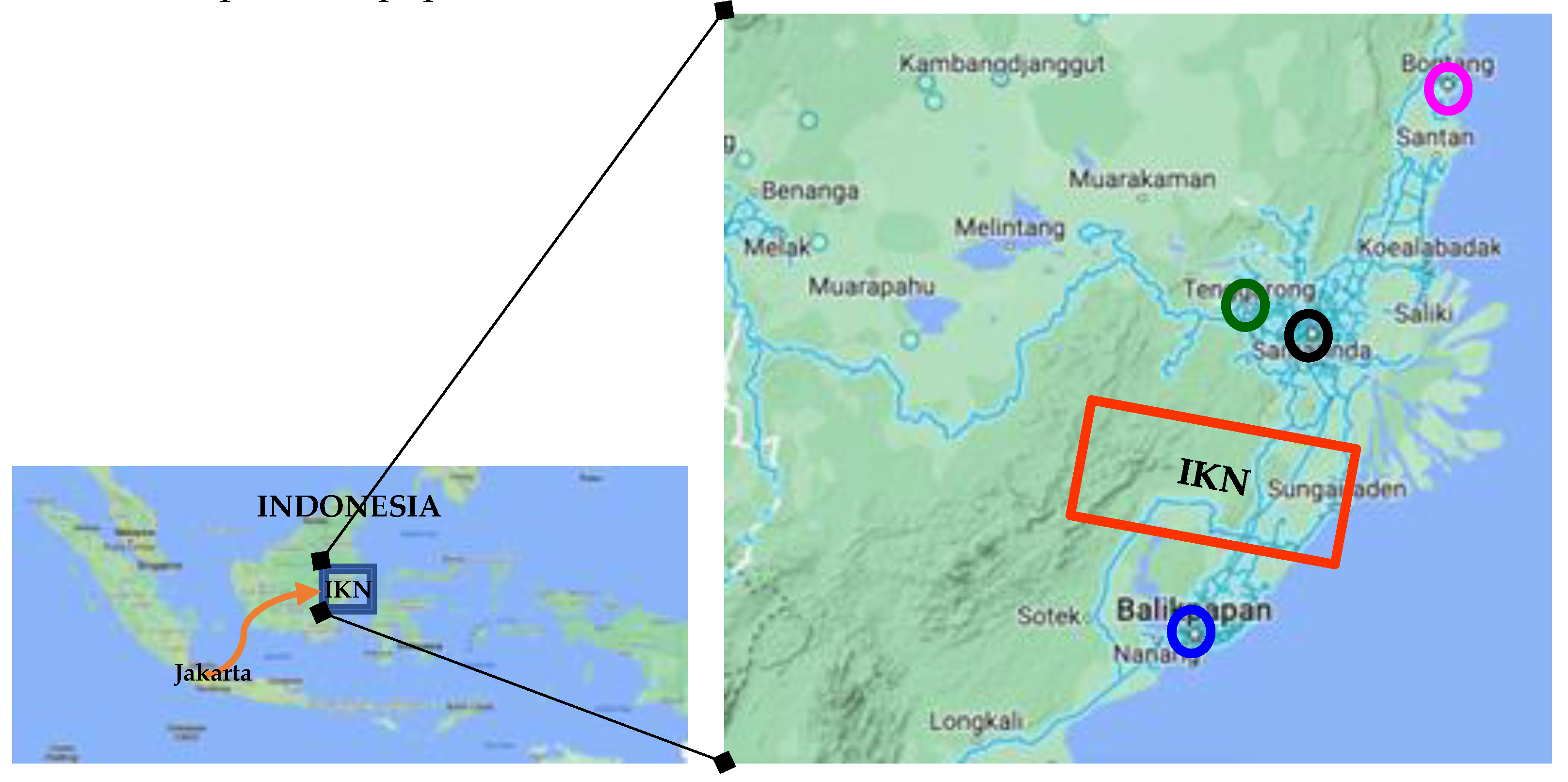
Figure 2.
Javascript syntax in GEE for data processing in December-January-February 2001-2005.
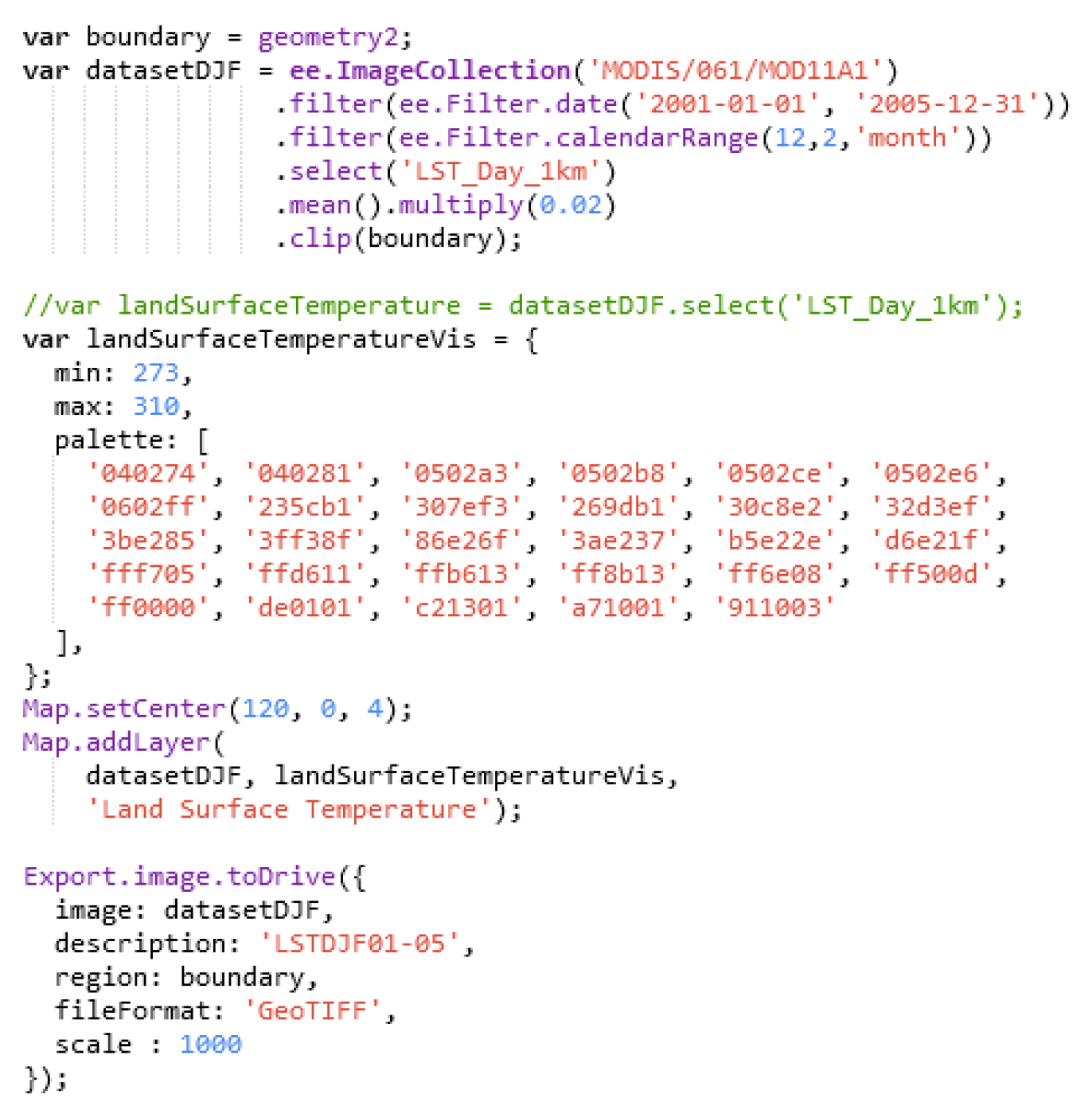
Figure 3.
LST Seasonal IKN, (a) DJF 2001-2005, (b) DJF 2006-2010, (c) DJF 2011-2015, (d) DJF 2016-2020, (e) MAM 2001-2005), (f) MAM 2006-2010, (g) MAM 2011-2015, (h) MAM 2016-2020, (i) JJA 2001-2005, (j) JJA 2006-2010, (k) JJA 2011-2015, (l) JJA 2016-2020, (m) SON 2001-2005, (n) SON 2006-2010), (o) SON 2011-2015, and (p) SON 2016-2020.
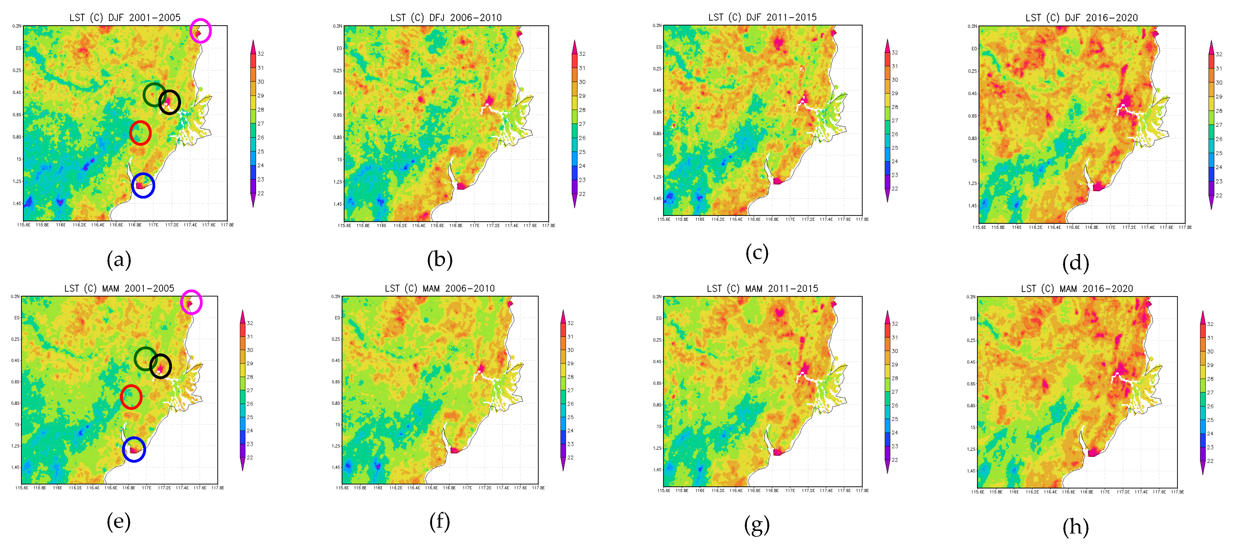
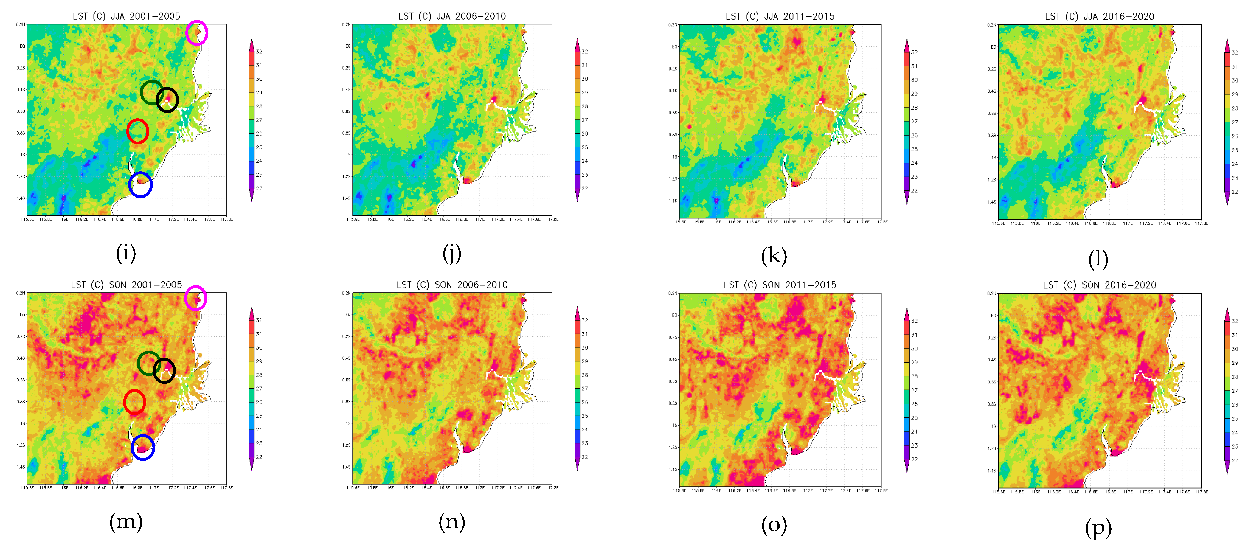
Figure 4.
Monthly maximum air temperature (OC) 2019-2020 in Samarinda and Balikpapan, East Kalimantan [14,15,16,17].
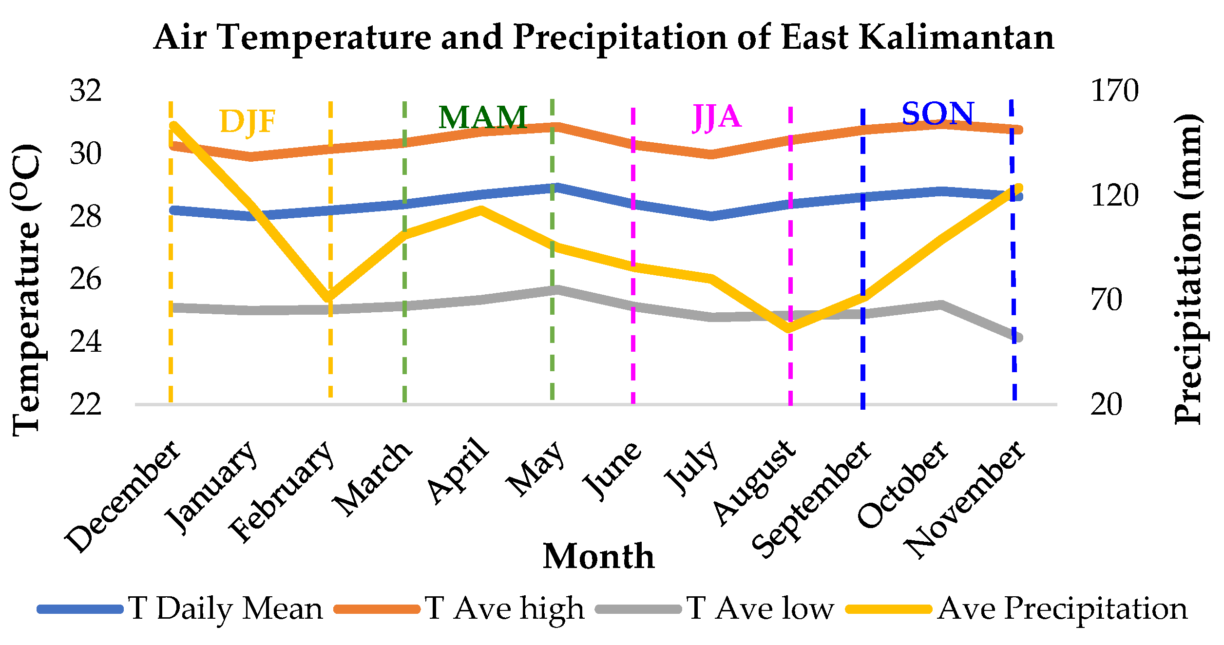
Figure 5.
LST Seasonal (DJF, MAM, JJA, SON) 2001 – 2020.
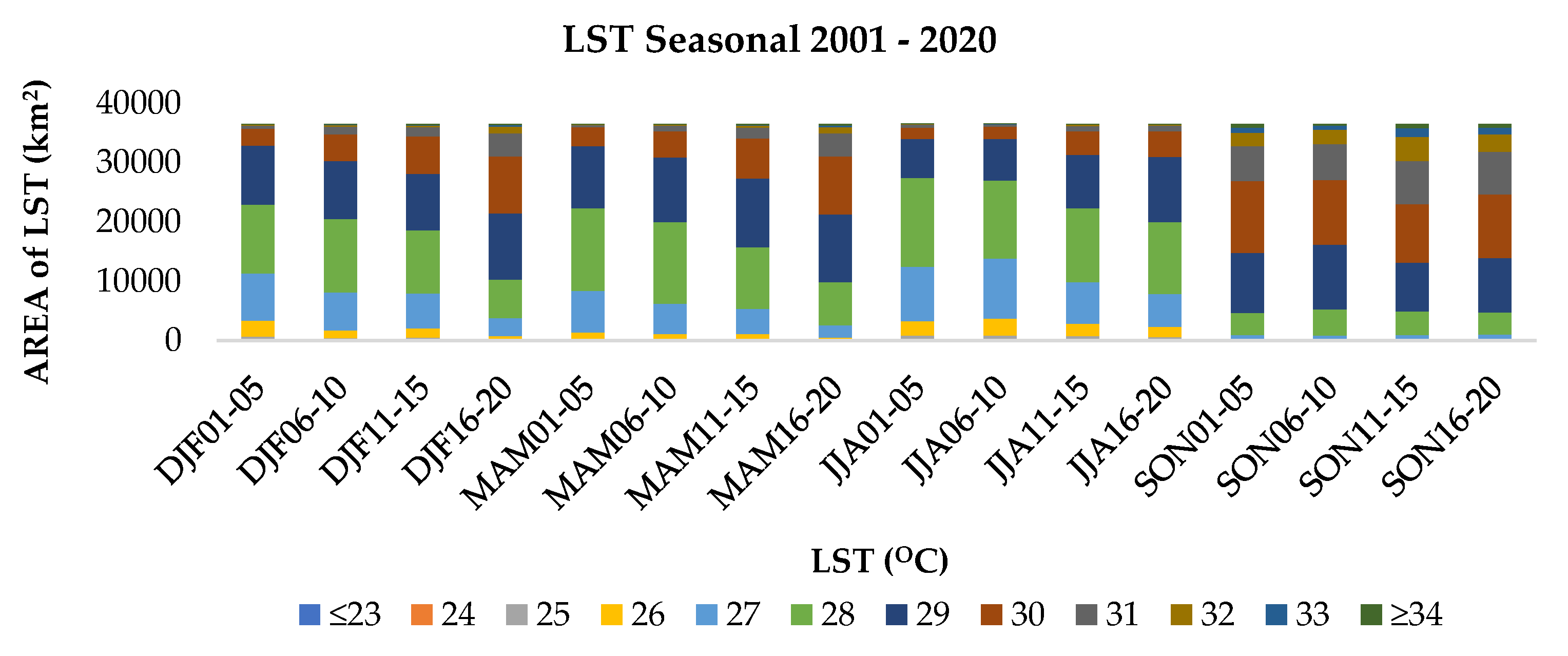
Figure 6.
LST area changes compared to 2001-2005.
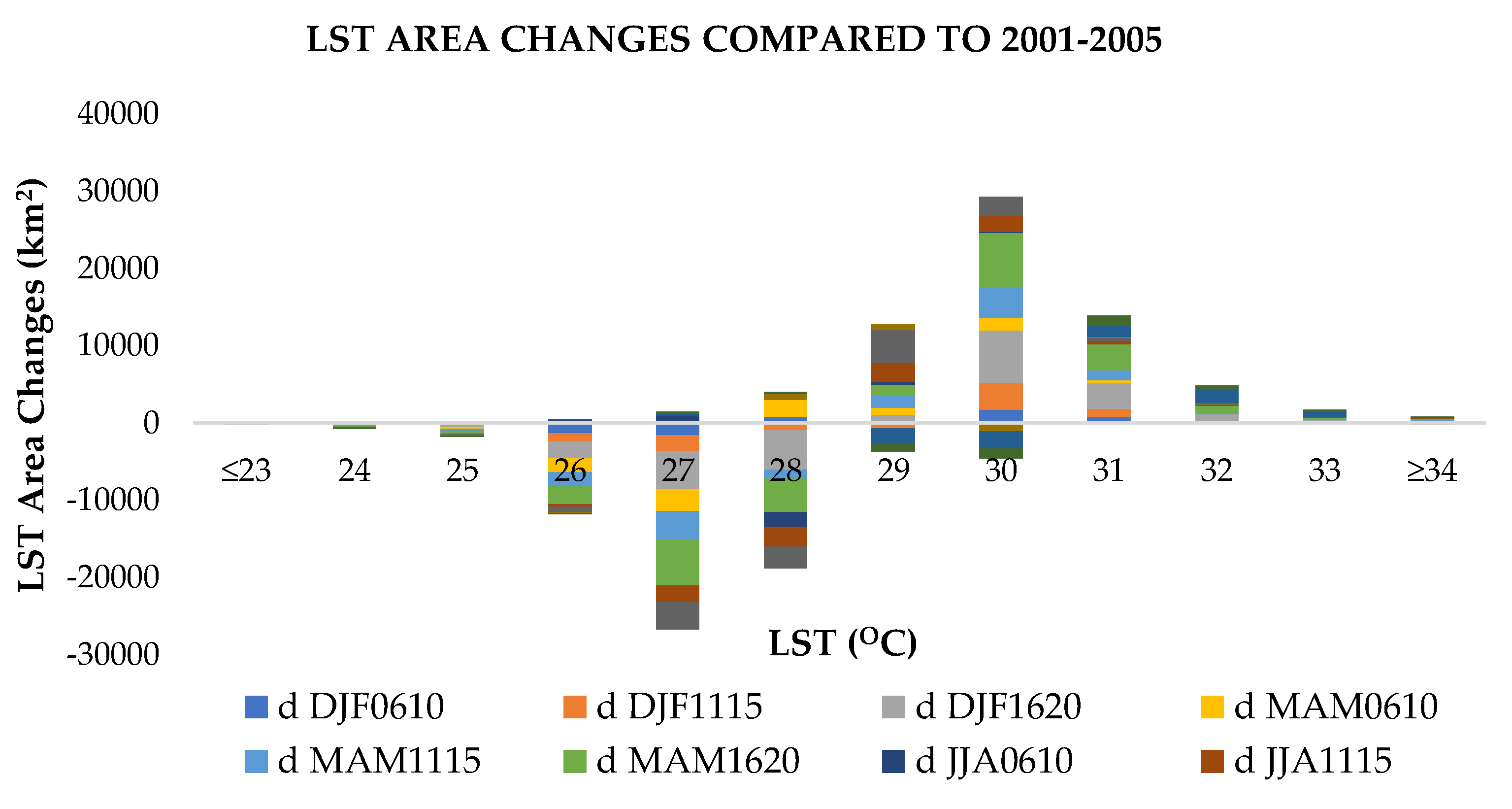
Figure 7.
LST Seasonal changes in the same location, (a) DJF 2006-2010 – DJF 2001-2005, (b) DJF 2011-2015 - DJF 2001-2005, (c) DJF 2016-2020 – DJF 2001-2005, (d) MAM 2006-2010 – JJA 2001-2005, (e) MAM 2011-2015 - MAM 2001-2005, (f) MAM 2016-2020 – MAM 2001-2005, (g) JJA 2006-2010 – JJA 2001-2005, (h) JJA 2011-2015 – JJA 2001-2005, (i) JJA 2016-2020 – JJA 2001-2005, (j) SON 2006-2010 – SON 2001-2005, (k) SON 2011-2015 – SON 2001-2005, and (l) SON 2016-2020 – SON 2001-2005.
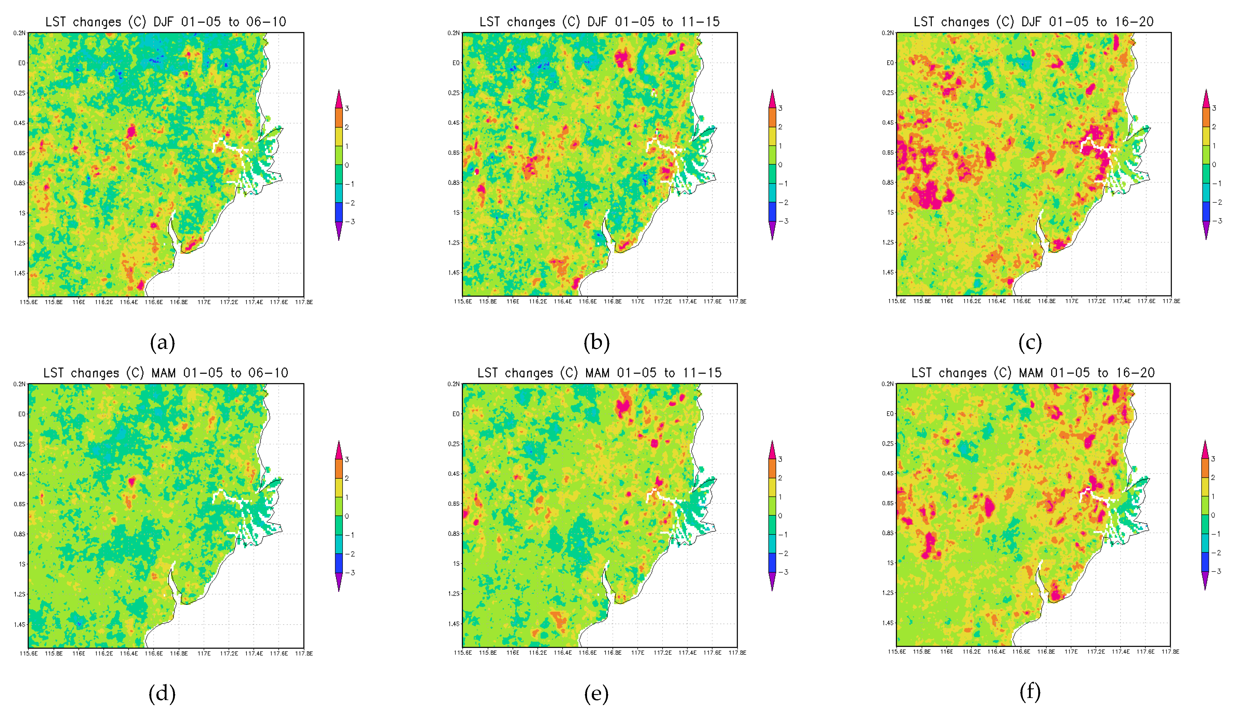
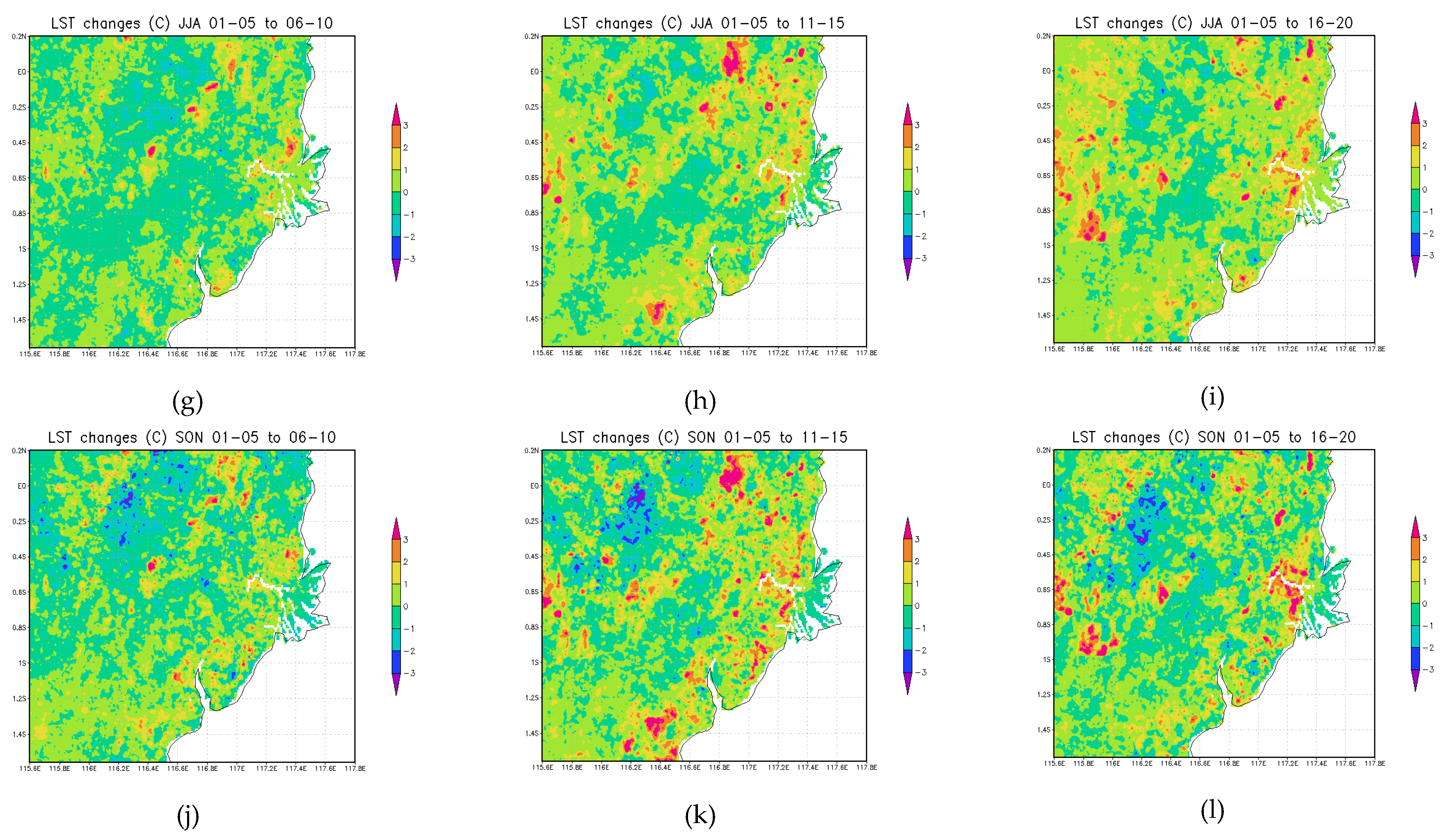
Figure 8.
LST changes (≤ -2 OC to ≥ 4 OC) at the same location.
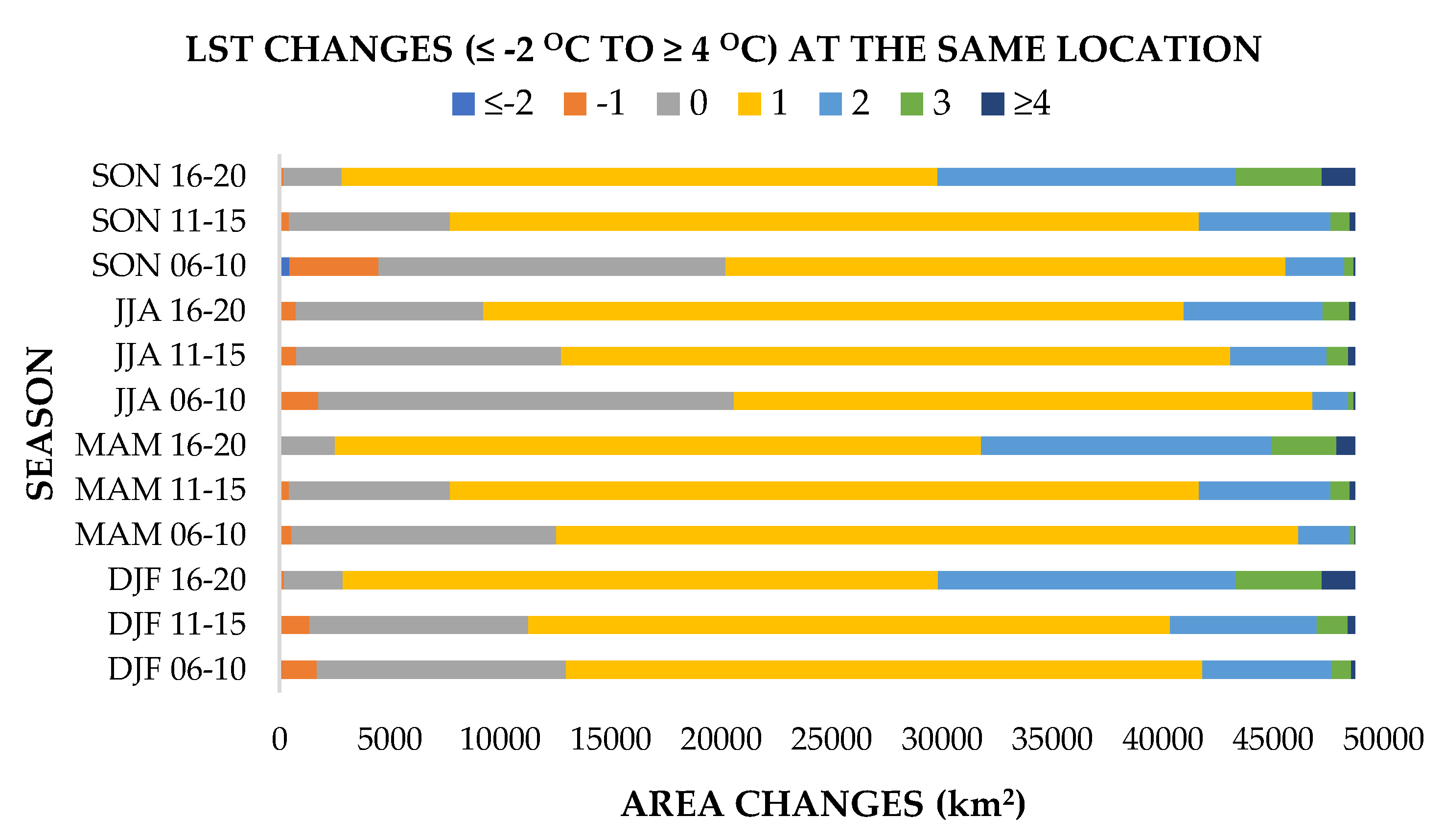
Figure 9.
LST Seasonal in Balikpapan, Samarinda, Bontang and IKN zero point.
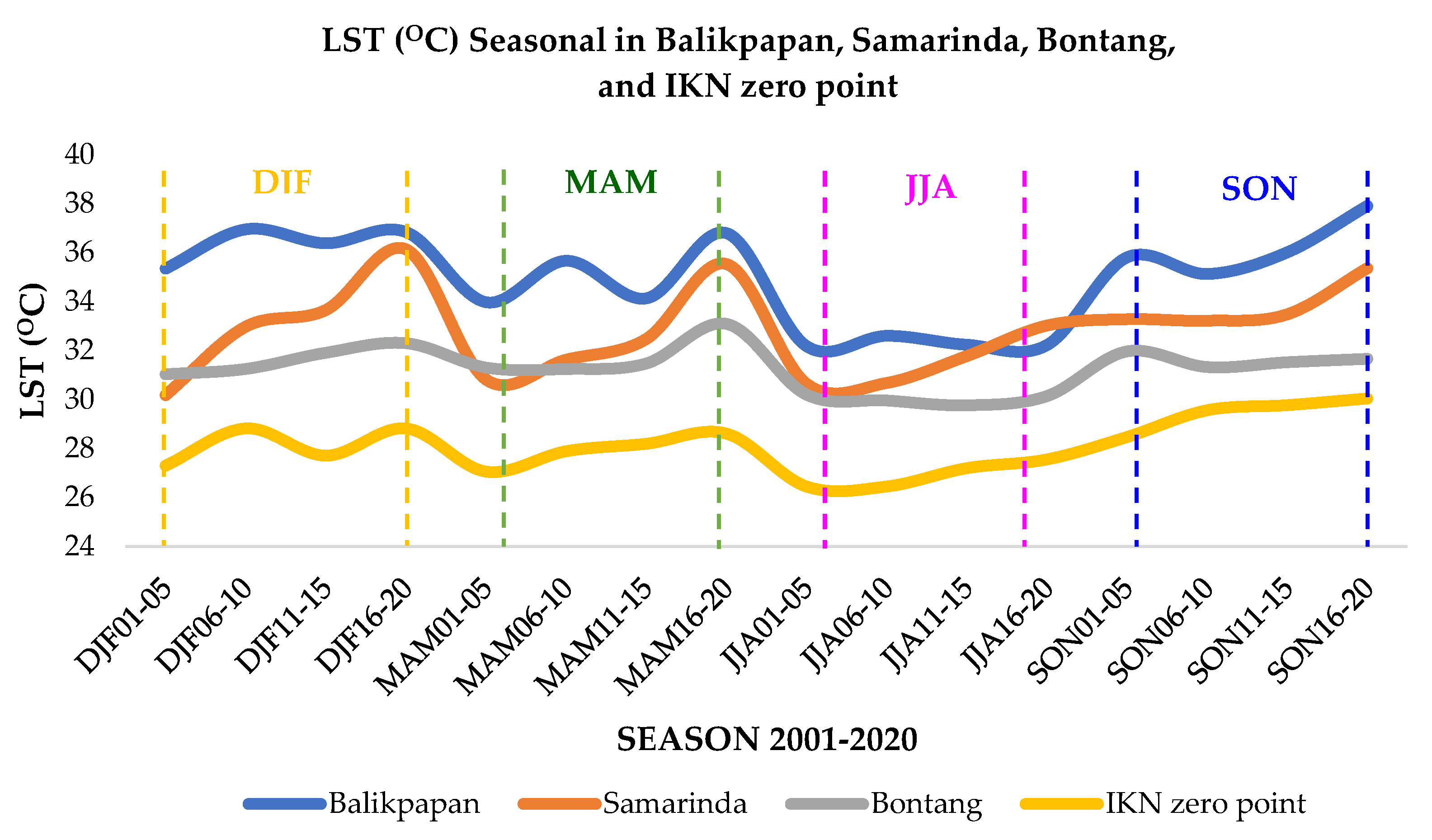
Figure 10.
Cross-section of LST DJF 2016-2020 in 4 places: Bontang City (purple circle), Samarinda City (black circle), IKN zero point (red circle), and Balikpapan City (blue circle). .
Figure 10.
Cross-section of LST DJF 2016-2020 in 4 places: Bontang City (purple circle), Samarinda City (black circle), IKN zero point (red circle), and Balikpapan City (blue circle). .
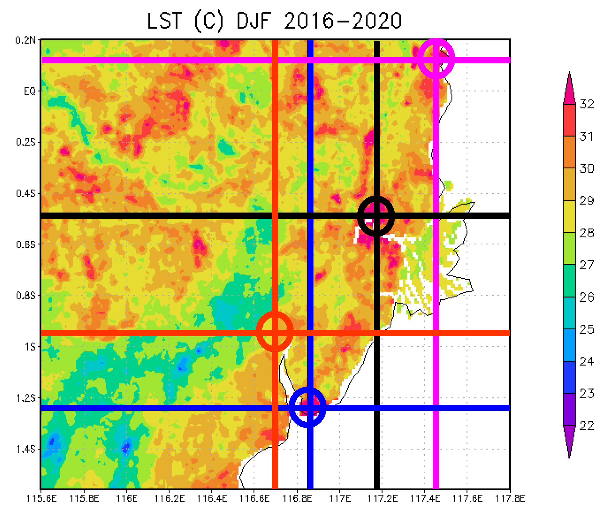
Figure 11.
Graphics of Cross Section LST DJF 2016-2020 in 4 places, namely Balikpapan City (blue circle) latitudinal (a) and longitudinal (b); Samarinda City (black circle) latitudinal (c) and longitudinal (d); Bontang City (purple circle) latitudinal (e) and longitudinal (f); and IKN zero point (red circle) latitudinal (g) and longitudinal (h).
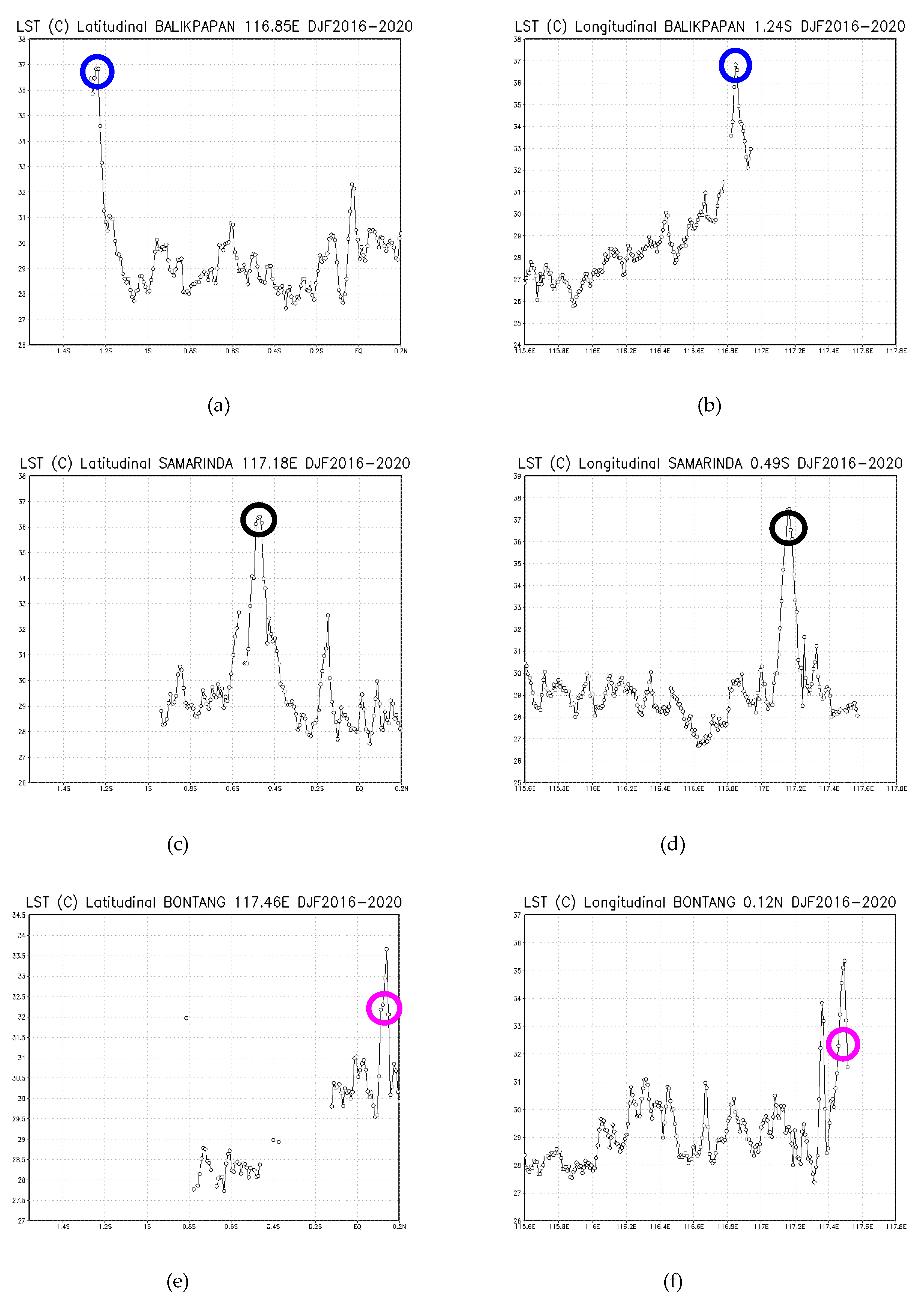
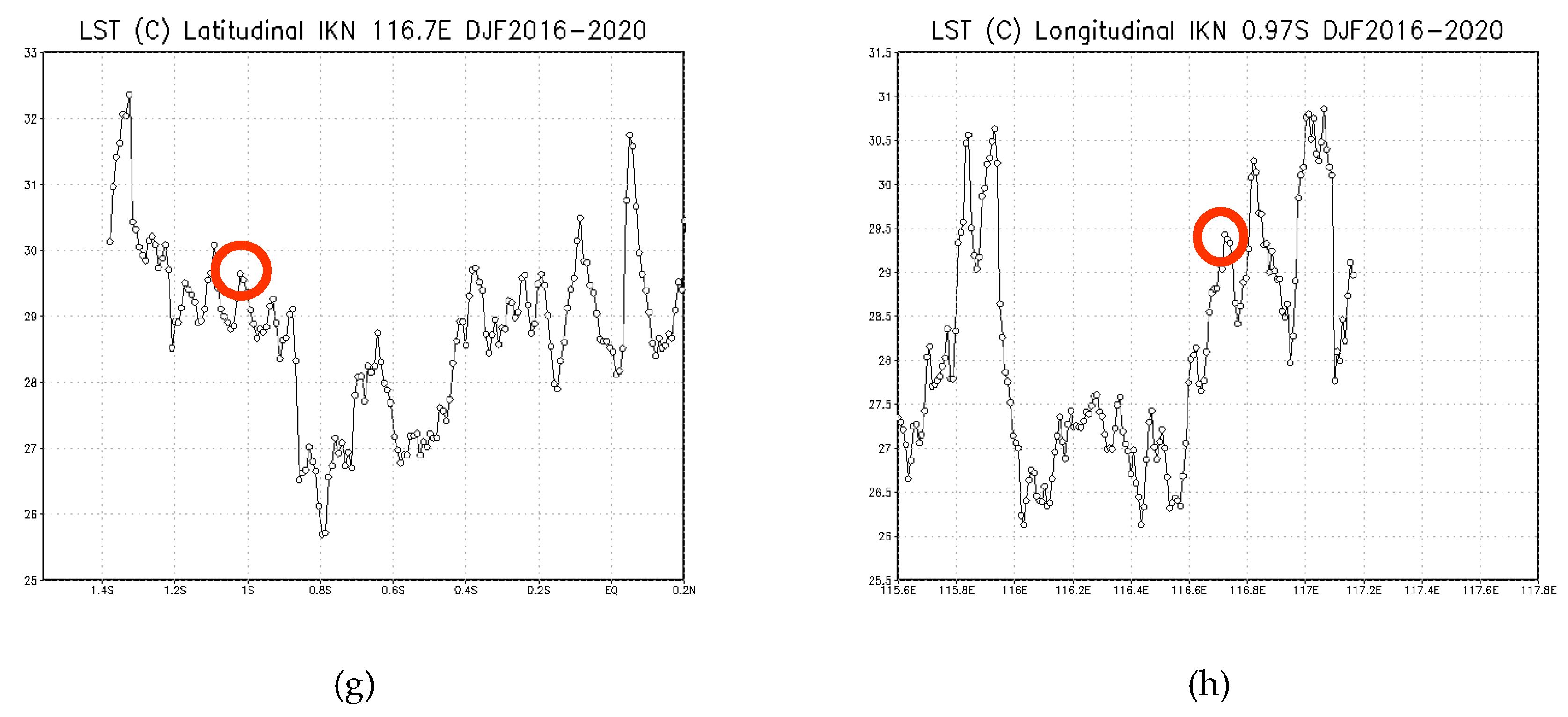

Table 1.
LST (OC) and area of LST (km2) Seasonal.
| LST (0C) | AREA OF LST SEASONAL (km2) | ||||||||||||||||||||||||||
|---|---|---|---|---|---|---|---|---|---|---|---|---|---|---|---|---|---|---|---|---|---|---|---|---|---|---|---|
| DJF 01-05 | DJF 06-10 | DJF 11-15 | DJF 16-20 | MAM 01-05 | MAM 06-10 | MAM 11-15 | MAM 16-20 | JJA 01-05 | JJA 06-10 | JJA 11-15 | JJA 16-20 | SON 01-05 | SON 06-10 | SON 11-15 | SON 16-20 | ||||||||||||
| ≤ 23 | 39 | 4 | 21 | 1 | 0 | 11 | 6 | 2 | 28 | 26 | 22 | 1 | 0 | 0 | 0 | 2 | |||||||||||
| 24 | 134 | 59 | 92 | 24 | 24 | 51 | 23 | 3 | 139 | 117 | 74 | 58 | 3 | 1 | 2 | 1 | |||||||||||
| 25 | 430 | 281 | 329 | 122 | 206 | 195 | 154 | 47 | 631 | 664 | 580 | 445 | 62 | 18 | 28 | 7 | |||||||||||
| 26 | 2686 | 1330 | 1599 | 606 | 1115 | 779 | 849 | 391 | 2415 | 2836 | 2083 | 1729 | 180 | 82 | 120 | 123 | |||||||||||
| 27 | 7954 | 6365 | 5879 | 2992 | 6981 | 5131 | 4250 | 2117 | 9169 | 10154 | 7075 | 5591 | 622 | 681 | 773 | 876 | |||||||||||
| 28 | 11589 | 12394 | 10592 | 6531 | 13962 | 13777 | 10427 | 7224 | 14960 | 13118 | 12420 | 12128 | 3702 | 4426 | 3939 | 3712 | |||||||||||
| 29 | 10008 | 9758 | 9542 | 11089 | 10402 | 10860 | 11535 | 11434 | 6618 | 7061 | 9021 | 10919 | 10203 | 10915 | 8252 | 9116 | |||||||||||
| 30 | 2820 | 4491 | 6317 | 9639 | 3248 | 4449 | 6817 | 9791 | 1888 | 1999 | 3985 | 4361 | 12032 | 10927 | 9817 | 10753 | |||||||||||
| 31 | 551 | 1338 | 1589 | 3883 | 362 | 930 | 1810 | 3914 | 497 | 351 | 878 | 954 | 5886 | 6017 | 7284 | 7201 | |||||||||||
| 32 | 151 | 253 | 252 | 1085 | 70 | 152 | 335 | 1022 | 70 | 66 | 182 | 145 | 2302 | 2421 | 4034 | 2913 | |||||||||||
| 33 | 34 | 71 | 100 | 283 | 23 | 41 | 108 | 273 | 14 | 27 | 68 | 52 | 878 | 693 | 1513 | 1150 | |||||||||||
| ≥ 34 | 14 | 38 | 49 | 74 | 25 | 27 | 54 | 82 | 3 | 6 | 37 | 25 | 371 | 174 | 421 | 372 | |||||||||||
| Total | 36435 | 36435 | 36435 | 36435 | 36435 | 36435 | 36435 | 36435 | 36435 | 36435 | 36435 | 36435 | 36435 | 36435 | 36435 | 36435 | |||||||||||
Table 2.
LST area changes compared to 2001-2005.
| LST (OC) | LST AREA CHANGES COMPARED TO 2001-2005 (km2) | |||||||||||
|---|---|---|---|---|---|---|---|---|---|---|---|---|
| dDJF 06-10 | dDJF 11-15 | dDJF 16-20 | dMAM 06-10 | dMAM 11-15 | dMAM 16-20 | dJJA 06-10 | dJJA 11-15 | dJJA 16-20 | dSON 06-10 | dSON 11-15 | dSON 16-20 | |
| ≤ 23 | -35 | -18 | -38 | -28 | -33 | -37 | -2 | -6 | -27 | 0 | 0 | 2 |
| 24 | -75 | -42 | -110 | -83 | -111 | -131 | -22 | -65 | -81 | -2 | -1 | -2 |
| 25 | -149 | -101 | -308 | -235 | -276 | -383 | 33 | -51 | -186 | -44 | -34 | -55 |
| 26 | -1356 | -1087 | -2080 | -1907 | -1837 | -2295 | 421 | -332 | -686 | -98 | -60 | -57 |
| 27 | -1589 | -2075 | -4962 | -2823 | -3704 | -5837 | 985 | -2094 | -3578 | 59 | 151 | 254 |
| 28 | 805 | -997 | -5058 | 2188 | -1162 | -4365 | -1842 | -2540 | -2832 | 724 | 237 | 10 |
| 29 | -250 | -466 | 1081 | 852 | 1527 | 1426 | 443 | 2403 | 4301 | 712 | -1951 | -1087 |
| 30 | 1671 | 3497 | 6819 | 1629 | 3997 | 6971 | 111 | 2097 | 2473 | -1105 | -2215 | -1279 |
| 31 | 787 | 1038 | 3332 | 379 | 1259 | 3363 | -146 | 381 | 457 | 131 | 1398 | 1315 |
| 32 | 102 | 101 | 934 | 1 | 184 | 871 | -4 | 112 | 75 | 119 | 1732 | 611 |
| 33 | 37 | 66 | 249 | 7 | 74 | 239 | 13 | 54 | 38 | -185 | 635 | 272 |
| ≥ 34 | 52 | 84 | 141 | 20 | 82 | 178 | 10 | 41 | 46 | -311 | 108 | 16 |
Table 3.
Area of LST changes (≤ -2 OC to ≥4 OC) at the same location.
| dLST (0C) | AREA of LST changes (≤ -2 OC to ≥ 4 OC) at the same location (km2) | ||||||||||||||
|---|---|---|---|---|---|---|---|---|---|---|---|---|---|---|---|
| DJF 06-10 | DJF 11-15 | DJF 16-20 | MAM 06-10 | MAM 11-15 | MAM 16-20 | JJA 06-10 | JJA 11-15 | JJA 16-20 | SON 06-10 | SON 11-15 | SON 16-20 | Ave-rage | |||
| ≤ -2 | 119 | 94 | 36 | 8 | 5 | 6 | 22 | 4 | 24 | 456 | 5 | 2 | 65 | ||
| -1 | 1582 | 1266 | 183 | 538 | 441 | 124 | 1745 | 772 | 736 | 4047 | 441 | 183 | 1005 | ||
| 0 | 11297 | 9921 | 2656 | 12006 | 7299 | 2400 | 18812 | 12003 | 8492 | 15697 | 7299 | 2656 | 9212 | ||
| 1 | 28787 | 29052 | 26934 | 33587 | 33886 | 29237 | 26211 | 30275 | 31696 | 25367 | 33886 | 26967 | 29657 | ||
| 2 | 5860 | 6653 | 13503 | 2357 | 5966 | 13169 | 1609 | 4376 | 6297 | 2651 | 5966 | 13503 | 6826 | ||
| 3 | 897 | 1385 | 3897 | 192 | 881 | 2943 | 247 | 976 | 1198 | 419 | 881 | 3897 | 1484 | ||
| ≥ 4 | 166 | 337 | 1499 | 20 | 230 | 829 | 62 | 302 | 265 | 71 | 230 | 1500 | 459 | ||
Table 4.
LST Seasonal in Balikpapan, Samarinda, Bontang and IKN zero point.
| CITY | LST SEASONAL (OC) | |||||||||||||||||||||||||||
|---|---|---|---|---|---|---|---|---|---|---|---|---|---|---|---|---|---|---|---|---|---|---|---|---|---|---|---|---|
| DJF 01-05 | DJF 06-10 | DJF 11-15 | DJF 16-20 | MAM 01-05 | MAM 06-10 | MAM 11-15 | MAM 16-20 | JJA 01-05 | JJA 06-10 | JJA 11-15 | JJA 16-20 | SON 01-05 | SON 06-10 | SON 11-15 | SON 16-20 | |||||||||||||
| Balikpapan | 35.35 | 36.95 | 36.38 | 36.84 | 33.98 | 35.67 | 34.13 | 36.80 | 32.18 | 32.60 | 32.24 | 32.22 | 35.80 | 35.13 | 36.01 | 37.91 | ||||||||||||
| Samarinda | 30.18 | 32.98 | 33.66 | 36.13 | 30.82 | 31.63 | 32.48 | 35.53 | 30.64 | 30.68 | 31.77 | 33.02 | 33.28 | 33.22 | 33.48 | 35.36 | ||||||||||||
| Bontang | 31.03 | 31.25 | 31.91 | 32.30 | 31.30 | 31.25 | 31.47 | 33.09 | 30.20 | 29.96 | 29.76 | 30.14 | 31.96 | 31.33 | 31.52 | 31.66 | ||||||||||||
| IKN 0 point | 27.30 | 28.82 | 27.71 | 28.82 | 27.05 | 27.89 | 28.19 | 28.61 | 26.45 | 26.45 | 27.20 | 27.55 | 28.47 | 29.56 | 29.77 | 30.04 | ||||||||||||
Disclaimer/Publisher’s Note: The statements, opinions and data contained in all publications are solely those of the individual author(s) and contributor(s) and not of MDPI and/or the editor(s). MDPI and/or the editor(s) disclaim responsibility for any injury to people or property resulting from any ideas, methods, instructions or products referred to in the content. |
© 2023 by the authors. Licensee MDPI, Basel, Switzerland. This article is an open access article distributed under the terms and conditions of the Creative Commons Attribution (CC BY) license (http://creativecommons.org/licenses/by/4.0/).
Copyright: This open access article is published under a Creative Commons CC BY 4.0 license, which permit the free download, distribution, and reuse, provided that the author and preprint are cited in any reuse.


