Submitted:
03 March 2023
Posted:
06 March 2023
You are already at the latest version
Abstract
Streets are an essential element of urban safety governance and urban design, but they are designed with little regard for possible gender differences. This study proposes a safety perception evaluation method from the female perspective based on street view images (SVIs) and mobile phone data, taking the central city of Guangzhou as an example. The method relies on crowdsourced data and uses a machine learning model to predict the safety perception map. It combines the simulation of women's walking commuting paths to analyse the areas that need to be prioritised for improvement. Multiple linear regression was used to explain the relationship between safety perception and visual elements. The results showed the following: 1) There were differences in safety perceptions across genders. Women gave overall lower safety scores and more dispersed distribution of scores. 2) Approximately 11% of the streets in the study area showed weak perceived safety, and approximately 3% of these streets have high pedestrian flows and require priority improvements. 3) Safe visual elements in SVIs included the existence of roads, sidewalks, cars, railways, people, skyscrapers, and trees. Our findings can help urban designers determine how to evaluate urban safety and where to optimise key areas. Both have practical implications for urban planners seeking to create urban environments that promote greater safety.
Keywords:
perceived safety
; women
; urban science
; mobile phone data
; street view
1. Introduction
Since ancient times, safety has been the first requirement of city construction. A city must provide the best opportunities for everyone to develop in conditions that guarantee freedom and security, which is also an important goal of sustainable urban development [1]. Streets, as essential links between private space and public space, assume the functions of daily transportation, life, and cultural expression and are urban spaces with high frequency of use [2]. So, more specifically, street safety is the primary objective of street space design as it directly affects the social activities of pedestrians. For example, a street that feels safe may have more people moving and walking around [3]; street safety may even have effects on mental health [4]. Therefore, it is particularly important to assess the safety perception of every street in the city.
Numerous studies in the field of urban planning show that the perception of qualitative traits such as safety is influenced by the visual components of the urban environment [5,6,7]. Recent studies have proposed methods to predict citizens' subjective perceptions at the urban scale [5], which also includes the evaluation of subjective safety perceptions of streets [5,8]. While the results of these studies evaluate urban street safety to some extent, the populations evaluated in these studies are mixed, ignoring the differences in perceived outcomes between populations with different characteristics. For example, studies in urban planning and other fields have confirmed that perceived safety may be related to such demographic characteristics as gender [6,9,10], age [9,11,12], and educational background [13,14].
Our hypothesis in this study is that the evaluation of safety perception should be conducted using females subjects, not a gender-mixed population and that men cannot fully imitate women’s perceived safety evaluations. We propose this hypothesis because, on the one hand, women use the streets more and they are the biggest beneficiaries of street safety, and on the other hand, women are usually more sensitive to warning signs of safety than men [15]. Therefore, the results of a mixed-population evaluation may not meet women's actual safety needs. This hypothesis has been confirmed by the experience of several city projects that resulted in the development of the Women's Safety Audit (WSA) [16]. Specifically, the WSA is a method for assessing the safety of community spaces through the involvement of professional designers and women in the community. The methodology was first implemented in Toronto in the late 1980s and has been used to assess and improve public spaces where women have been subjected to crime. Later, this methodology was extended to a more general assessment of safety and improvement of the urban built environment, and it became an integral part of the safe cities project [17]. In general, the WSA respects and responds to the subjective perceptions of the people who use the public space, using a gender-specific evaluation approach at an early stage of the project.
Finally, a problem that always arises in the actual implementation of urban planning projects is that, constrained by the time and financial cost of planning programs, urban renewal projects do not support large-scale urban street surveys and renovations. To improve the efficiency of implementing urban planning programs, it is crucial to identify the places that urgently need renovation or maintenance so that funds can be allocated for urban construction in a sensible manner. The focus of this study is on walking routes between home/work and public transportation, as this is likely to be a mandatory part of a woman's daily commute. Therefore, we simulated the pedestrian flow on the streets using mobile phone data and tried to identify which streets have a low sense of safety but a high pedestrian flow so that they cab be prioritised for improvement.
In short, our research objectives are as follows: (1) How should street safety be evaluated scientifically? (2) Where are the streets that need to be further prioritised for improvement? (3) What should be incorporated in the improved street to increase perceived safety? This study proposes a safety perception evaluation method from the female perspective based on street view images (SVIs) and mobile phone data, taking the central city of Guangzhou as an example. Specifically, this study collected safety evaluation data on SVI from three groups (female, male, and hypothetical) with a total of 50 volunteers, and identified the female group as the main group for the follow-up study. We integrate machine learning (ML) prediction and ArcGIS path analysis to link street safety perception with the street pedestrian flow and further identify streets that urgently need improvement. The results of the study provide insights into how to scientifically evaluate street safety and where to retrofit to improve street safety perception. Our work enriches the studies of subjective measures of perceived safety and is the first study to test whether males-imitating-females perceive environments the same as females. Furthermore, we propose to model people's potential walking commuting paths through work and home position information from mobile phone data. An overlay analysis based on these two elements identifies streets that need priority safety improvements.
This paper is organized as follows: Section 2 provides a review of studies related to the analysis of perceived safety, urban landscape sense perception, and simulated street pedestrian flow. Section 3 describes the study area and data collection efforts. Section 4 describes the methods used, including image processing, machine learning modelling, and simulation of women's walking commuting paths. Section 5 shows the estimation results and the application of the model in Guangzhou city. Section 6 provides a discussion of the results and their limitations, while Section 7 concludes the paper.
2. Literature review
2.1. Street safety and female safety
Firstly, perceived safety needs to be defined. It is important to emphasise in advance that the definition of perceived safety is very broad, with some being objective, such as crime and crash rates in the region [18,19,20], and some being subjective, such as people's perceived evaluations [5,21,22]. We refer to some well-known streetscape perception studies to emphasise that this study refers to perceived safety in a broader sense related to types of human emotion [5,21,22]. More specifically, the place where perceived safety was evaluated in these studies was the street space.
Street safety means that the behaviours and state of others on the street are free from threats and violations and the safe conduct of all legitimate human behaviour on the street is guaranteed [23,24]. The safety perception of public spaces comes mainly from management services and the physical environment [25]. Traditionally, the most common method to ensure safety is maintenance and law enforcement, which means more police, monitors, tougher laws, etc.; in areas that are well policed and managed, crime and anti-social behaviour that threaten public safety are naturally rare. However, in today's increasingly complex urban systems, street safety by police and law alone is not enough [26]; in addition, the frequent presence of police systems can also create some unsafe feelings.
In addition, Crime Prevention Through Environment Design (CPTED) is also an important component of the approach that this study seeks to explore. CPTED is designed to enhance the safety perception of pedestrians through the design of urban spaces [27,28], and it has been widely used to enhance urban safety in regions such as Europe and the USA [29]. Similarly, the concept of the 'street eye' proposed by Jacobs [30] also emphasizes the impact of environmental design on the perception of street safety.
Every day, women globally are subjected to unwanted crimes and harassment while out and about [31]. The danger of sexual harassment or physical assault (such as being robbed or mugged) is two to four times higher for women than for men, according to a 2004 report by the Department for Transport in the UK [32]. The WSA case points to the fact that women are both victims of space security issues and possibly the best guardians of space safety [16]. Cities such as Vienna, Berlin, and Vancouver have established women's advisory committees in their spatial planning or governance systems, using gender as one of the main perspectives in spatial policy making. These cities further practice urban development strategies that are safe and inclusive for all, so that the needs of all people, including women, are equally respected and taken into account [33,34]. Therefore, it is necessary to take a women's perspective on the safety of the streets.
2.2. New data and technology for measuring street safety levels
2.2.1. Street view images and deep learning
Based on publicly available, geographically attributed data from street view images (SVIs) and a deep learning (DL) model, the visual elements in the SVIs can be objectively measured. One on hand, SVI is different from traditional planar datasets. Because the SVI provides a horizontal view of the street environment, close to the perceived sight level of pedestrians, it can be used as an alternative to live evaluation [35,36]; therefore, SVIs are an ideal data source for the human-centred evaluation of street spaces. On the other hand, SVI data are more easily available and have wider data coverage (e.g., publicly available at the urban scale) than traditional methods such as on-site audits [37,38,39]. This wide coverage can compensate for possible omissions in sample surveys or small-scale representative studies, making it possible to understand large-scale urban scenarios. In addition, with the development of Computer Vision (CV), the automatic extraction of SVI features has become possible, including measuring the percentage of greenery within the line of sight [40] and measuring the proportion of visual elements such as pedestrians, vehicles, traffic signs, the sky, and buildings [41,42,43,44].
2.2.2. Subjective perception and machine learning
However, objectively quantified proportions of visual elements are not representative of pedestrians' overall perception of the street environment, and subjective frames perform better for perceptual qualities that are unfamiliar to people [7]. Gender differences in perceived safety have been demonstrated in small-scene studies in fields such as environmental psychology using image data. For example, Jiang et al. recruited volunteers to participate in a photo questionnaire survey [45]. The results of the study showed that men's perceived safety was generally higher than women's in all types of scenes; however, in scenes with complete urban functions and vegetation scenes, perceived safety was higher for both men and women, and the gender difference basically disappeared. Baran et al. used a VR experiment to allow volunteers to experience perceived safety in eight scenarios in a park [46]. The results of the study showed that, in seven scenarios, women had lower mean perceived safety scores than men, and the remaining one was the only environment in which men and women had the same mean perceived safety. These studies confirm the feasibility of using a virtual scenario (off-site) approach to evaluating scenario safety.
Furthermore, integrating Crowdsourcing with Artificial Intelligence (AI) has become feasible for revealing large-scale public perceptions [21,47]. Naik et al. [22] used perceived safety information about urban areas online by MIT Place Pulse datasets, which asked volunteers to rank the perceived safety in SVIs of urban areas. These preferences were transformed into ranked safety scores and used as training data to develop ML models that could predict perceived safety scores for 21 different cities worldwide [22]. Similarly, many studies objectively measure subjective human perception by establishing statistical relationships between visual elements and perceptual scores, for example, openness [48], complexity [49], continuity [50], and psychological stress [51]. These studies provide an actionable framework for this research.
2.2.3. Simulation of street pedestrian flows
Some studies calculate street accessibility through spatial syntax and further understand street accessibility as potential street pedestrian flow [8,52]. Spatial syntax studies the interaction between spatial networks and social activities and states that their interaction is based on the fact that humans will choose the most accessible paths in a spatial network [53]. This quantitative approach allows measuring the accessibility of streets (defined as the probability of a street space being traversed). The spatial syntax allows the simulation of urban street patterns related to the distribution of residents, identifying the most active urban street spaces and comparing them with residents' perceptions of street quality to provide data for future improvements in overall street quality [8,52].
With the proliferation of mobile phones and mobile Internet, mobile phone data offers the possibility of studying the movement of people on a large scale. Mobile phone data have the characteristics of high coverage and high holding rates, and the large sample size and rich information on individual spatio-temporal behaviour provides a new opportunity for the study of residents' commuting behaviour [54,55,56]. In addition, mobile phone data have user-based attributes that can further distinguish the gender population. Ahas et al. analysed urban residents' spatial and temporal distribution characteristics, including the commuting patterns of different populations, such as men and women [56]. Commuting is a regular social activity that can represent people's travel behaviour. The route from home and work to public transportation is a high-frequency purpose of street travel, and it should be the focus for safety because such a commute reduced mobile source air pollution and climate change. Thus, based on mobile phone data, it is possible to obtain the approximate location of each woman's home and workplace, simulate their likely walking paths during their commutes to work, and finally extrapolate the number of people on each street. Compared with the simulation results of spatial syntax, the simulation results based on mobile phone data can provide new perspectives that can help urban perception studies to further develop a more accurate evaluation.
2.3. The Gaps
Firstly, based on the subjective perception of SVIs, the work and algorithms are mature in evaluating street safety perceptions. But most studies take the whole city street as the measurement object, lacking further in-depth analysis, and the objects of the studies fail to focus on the high-frequency scenes of human activities. Secondly, subjective measurements allow for the collection of first-hand data and enable the effective incorporation of more subtle human perceptions, which can be linked to the results of objective measurements. However, the few studies that have incorporated human perceptions, whether built on the existing MIT Place Pulse dataset [21] or self-administered questionnaires collected through crowdsourcing [51,57,58], suffer from a lack of consideration of gender differences. Based on the safety perception evaluation from a female perspective and street pedestrian flow simulated using mobile phone data, this study can make a more valid assessment of street safety.
3. Study area, framework, and data
3.1. Study area
In southern China, Guangzhou is a popular case city for crime geography research in China [59,60]. Between the 1990s and the beginning of the 21st century, Guangzhou had one of the highest crime rates in the country [61]; coupled with its status as a mega-city in China, with a fast-moving and complex population, the problem of both property and violent crime was more prominent. Therefore, evaluating the safety of street spaces in Guangzhou is particularly necessary.
Guangzhou's urban centre covers a total area of 2,367 km². It comprises seven administrative districts: Yuexiu, Haizhu, Liwan, Tianhe, Baiyun, Huangpu, and Panyu (Figure 1). At the end of 2020, its resident population was 14,036,000 (sex ratio: 110.81), about 75% of the city's total population.
3.2. Conceptual Framework
The study was made following the model in (Figure 2). Firstly, the collected street view images (SVIs) were segmented using a DL model to quantify the SVIs to form a high-dimensional semantic feature dataset. Then, volunteers used software produced by Yao et al. to score the SVIs for safety perception [63]. Finally, we used ML models to predict the safety scores of the remaining SVIs and validate the reliability of the sense of safety map with actual crime data. Meanwhile, based on mobile phone data, this study obtained the approximate locations of where people live and work. The mobile phone data were combined with road data and public transport station data to simulate the pedestrian flow of the streets during people's commutes.
Next, street safety scores and street pedestrian flow are overlaid and analysed to identify four types of streets. Streets with a low safety score and high pedestrian flows (L-H) were identified as being the highest priority streets for improvement.
3.3. Data
3.3.1. Road
The road data were mainly used to determine sampling points for SVIs and walking paths for women during their commute. This study uses OpenStreetMap (OSM) as the data source for the road data (https://www.openstreetmap.org/ (accessed on October 17 2020)) and removes motorways and elevated roads from the data. Then, we considered the balance of error and sampling cost to obtain SVI sampling points at 40 m equal intervals [64]. After de-duplication, a total of 222,330 SVI sampling points were obtained.
3.3.2. SVIs
Based on the collection points calculated in Section 3.3.1, we download the SVIs’ data from Baidu Maps. These SVIs are 640 × 400 pixels in size, have a common camera setting (Figure 3b), and the SVIs themselves were taken in March 2020.
The overall spatial and quantitative distribution of sampling points was first considered in selecting the SVI sampling. Then, a representative sample of 2,500 SVIs were randomly sampled in proportion to the number of sample points within the neighbourhood blocks (Figure 3a). Finally, the SVIs were hand-selected1 to ensure the representativeness and validity of the sample street scenes. A total of 2,377 images were selected, of which typical SVI are shown in Figure 3c.
3.3.3. Subjective safety perception evaluation
A total of 50 local college students and staff from Guangzhou and Shenzhen (both in Guangdong Province) served as volunteers, and more detailed information on volunteer demographics can be found in Supplementary Materials Table S1 . There are two reasons for this selection of volunteers, which are directed at the number of volunteers and the social background. (1) Our study area is in China, so the MIT Place Pulse, a large and publicly available dataset that is widely used within urban perception research, was not used in the study. This is because both the volunteers and SVIs in this dataset were sourced from non-Chinese regions. Therefore, the number of volunteers in many Chinese urban perception studies will be limited, and the number of volunteers in these studies is mostly within 50 [7,43,52,58,62,63]. (2) Xu et al. [14] confirmed in a study in Shanghai, China, that there was some similarity between students' and residents' perceptions of safety, and their correlation coefficient R for SVI scores was 0.93 (p < 0.01). Similarly, Qiu et al. [7] and Ye et al. [52] selected a university-educated group for their study of urban perception based on street view imagery. This study involving human participants was reviewed and approved by the Medical Ethics Committee of Shenzhen University Health Science Center (reference: PN-202200089).
The volunteers were divided into three groups: female (G1, 20 women), mix (G2, 10 women and 10 men), and hypothesis (G3, 10 men) (Figure 4a). The age structure and educational background of the volunteers in each group were kept consistent. It should be noted that the hypothesis group (G3) was unique in that it was men who assumed the perceptions of women to score their perceptions of street safety. The role of the hypothesis group (G3) is to determine the substitutability of the safety evaluation for the female group (G1). Each volunteer was required to go through all the sample SVIs in general before scoring them. Volunteers were given a scoring range of 0 - 100 points (Figure 4b), and we informed volunteers in advance that 60 points was the threshold set by the study. Streets with fewer than 60 points on the SVI will be considered unsafe and in need of future improvement. Each team of five volunteers worked together to complete the scoring of 2,377 SVIs, and each volunteer was required to complete approximately 450 - 500 SVIs for scoring. In more detail, volunteers were required to complete the scoring of SVIs on a computer with the help of software created by Yao et al. [52]. The software created by Yao et al. [52] has a recommendation mechanism based on the labelling of visual elements to accelerate people's scorings, with each volunteer taking about half an hour to score about 500 SVIs. The scores for each SVI in G1, G2, and G3 were calculated by averaging the scores of four, two, and two persons, respectively.
3.3.4. Mobile phone data
The content of the mobile phone data in this study was extrapolated from a Chinese operator's data on Guangzhou City residency for an entire month in autumn 2020, totalling about 5.52 million people, or about 30% of the total population of Guangzhou city. These mobile phone data contain the gender of each user, the demographic weight of a location2, and the locations of the user’s work and residence3. Detailed residential or workplace information of any individual was not obtained in this study, and the location information of all users was based on the grid of the base station in their service area (Table 1). The data were collected this way, 38,549 grids were created based on the central city area of Guangzhou, with a grid size of 250 × 2504 m. Each grid is used to represent the residence or work area of the user. In this study, only female users were extracted. After pre-processing, such as data clearance and sample expansion, the number of female users living and working in each grid was counted. As a supplement, the grid summary results for the mobile phone data are shown in Supplementary Materials Figure S2.
3.3.5. Public transport station
Bus stops and metro station data were collected from Baidu Maps API (https://api.map.baidu.com/lbsapi/ (accessed on December 2, 2020)). After data clearance, we collected 4,421 bus stops and 274 metro stations in the study area.
4. Methods
4.1. Machine learning
4.1.1. Streetscape feature classification
In this study, it is necessary to establish the relationship between people's subjective perceived safety and the visual elements in the visual range. Therefore, it is necessary to extract instances of objects such as buildings, sky, roads, people, and cars from the original content of street view images (SVIs). Semantic scene parsing is needed to quickly and efficiently determine the physical spatial conditions of a street environment. Specifically, the purpose of semantic scene parsing is to identify and segment object instances in a natural image, and given an input image, the model can assign a category label to each pixel, a process known as a pixel-wise prediction.
This study divides and labels different pixel parts of the SVI using the pyramid scene parsing network (PSPNet) method, which is often used in other urban planning studies [5,40], to identify the physical spatial properties of the street environment. Since training directly based on data is time-consuming, pre-trained models are usually used for prediction. In this study, predictions were performed by downloading pre-trained weight files of PSPNet on the ADE20k dataset [65], which has a pixel-level accuracy of over 80.2% on cityscapes [66].
In this study, 166,024 SVIs were semantically segmented by this method, and the results are shown in Table S2 in the Supplementary Materials. It should be noted that only the 32 most common visual elements of SVI species are described in Table S2, and the remaining 118 categories of visual elements were not included in the analysis. This is because these 118 categories of visual elements are considered to have little relevance to the urban environment [6]. The average sum of these 118 categories of visual elements in all SVIs in this study is only 0.6%, which basically does not affect the essential research content of the subsequent study. It should also be noted that the visual element that appears most frequently in the SVI is "tree", which was one of the most common visual elements in studies using SVI-based data, and this visual element has been shown to profoundly influence perceptual evaluations [5,40,52].
4.1.2. Predicting subjective scores
The target output variable for this study was the perceived safety score of the women, whose data type was continuous. The variables to be input in the ML model are the 32 street-level features obtained in Section 4.1.1. In this study, we chose nine classical and mature ML algorithms to predict safety scores by referring to the study by Qiu et al. [58]; these are linear regression (OLS), K-nearest neighbour (KNN), support vector machine (SVM), random forest (RF), decision tree (DT), voting selection (VS), gradient boosting (GB), adaptive boosting (ADAB), and bagging regression (BR). These algorithms have been widely used in urban studies and have shown to be both effective and robust [5,67,68]. Two accuracy metrics are used to evaluate the performance of ML algorithms, which are the root mean square error (RMSE) and the mean absolute error (MAE). The best-performing (lowest error) ML model will be applied. The results of the prediction accuracy of the nine ML algorithms are presented in Section 5.3. The RMSE and MAE are calculated as follows:
where and represents the ML algorithm’s prediction and the real value of the th sample, respectively; is the number of samples.
4.2. Calculating female commuting paths
Commuting during the working day is a regular social group activity, and the path from home or work to transport facilities is a high-frequency process of walking through the streets (Figure 5). We assume that each woman has the same probability of choosing public transport for her commute.
This study uses grid-aggregated mobile phone data to calculate the path from each residential and work grid point to the nearest public transportation facility. In September 2020, the average daily passenger volume of public transportation in Guangzhou was 13.99 million. Regarding the share of modes of public transport, 31.32% of passengers took regular buses, 58.64% took rail transport, 9.79% took cabs, and 0.24% took water buses during this month [69]. Cabs are a point-to-point service, and the commute involves less time spent on foot in the streets, and the percentage of trips on water buses is too low; therefore, this study defines public transportation facilities as bus stops and metro stations (with a combined share of about 90% of passenger traffic).
Specifically, we build the network dataset based on OSM data and use the Network Analyst tool in ArcGIS Pro 2.5. Then, the centre point of the grid is used as the Origins (O) of the location of the residence and workplace, and the bus stops within 500 m and the nearest metro stations are used as Destinations (D) to calculate the walking path between O-Ds (Figure 6). Finally, the pedestrian flow of each OD path is distributed equally according to the proportional relationship between bus and metro passenger flow (about 1:2), respectively.
It should be emphasised that this part of the path is the one that people are most likely to walk through during their commute, but it is not the only one. However, this is not contradictory to identifying which streets need to be prioritised for improvement, although we may be overlooking some potentially high pedestrian flow paths.
5. Result and discussion
5.1. Differences in perceived safety between the three groups
To explore the heterogeneity of the safety perceptions of men and women, the scores of each street view images (SVIs) were evaluated by the female group (G1), mixed group (G2), and hypothesis group (G3). As shown in Figure 7a, the evaluation results were statistically different among the three groups (G1: μ = 61.2 and σ = 12.3; G2: μ = 62.9 and σ = 7.5; and G3: μ = 57.7 and σ = 9.1). There was a strong correlation between G1 and G2 (ρG1-G2=0.85) and a weak correlation between G1 and G3 (ρG1-G3=0.56).
The female group had lower mean scores for evaluating street safety than the mixed group. It is worth noting that the mean safety score for the Hypothesis group was 57.7, slightly lower than the mean score of 61.2 for the Female group, with more streets considered unsafe (<60) (Figure 7b). However, women's perceptions of street safety are more sensitive, with G1 having the largest standard deviation; G3 still has a gap compared to women's more nuanced perceptions, but the gap is smaller than G2.
Women's perceived safety scores are lower and more sensitive compared to the mixed-gender population. Therefore, the female group's perceived safety scoring not only satisfies their own needs, but also satisfies the needs of the mixed group. Moreover, there is an overcompensation in the perceived safety scoring of men imitating as the perceptions of women, and they also do not show the sensitivity of females. Therefore, the male group cannot replace the female group for perceived safety evaluation either. Therefore, in the following study, we used women's perceived safety scores as the dataset for predicting street safety scores in Guangzhou.
5.2. Safety score map
5.2.1. Selection of ML models
The scoring results of female volunteers (G1) were selected for machine learning, and the visual elements of SVIs (Supplementary Materials Table S2) were used as explanatory variables in the ML model to predict safety scores. As shown in Table 2, RF had the best fit in this study, with an RMSE of 8.8 and MAE of 6.5; both metrics had the smallest error among the nine ML algorithms, and an error of 6.5 will not alter the interpretation of the predicted quality with a 0–100 scoring system. Therefore, we chose the RF model to predict the scores of the remaining SVIs.
5.2.2. Subjective safety perception of urban street
- (1)
- Safety score map
We visualise the results of ML predictions in ArcGIS (Figure 8). In the Guangzhou example, the green locations indicate places that women consider unsafe, often concentrated in the suburbs, but also scattered in the central city; these streets are mostly the ends of roads. Lower road grades characterise streets with lower safety scores compared to streets with higher safety scores (Figure 9). The one exception is footpaths, which have a lower road class but have a higher safety score overall, ranking second among all road types. More specifically, footpaths refer to leisure walking trails, usually with green vegetation on each side of the path, such as square footpaths, park footpaths, and residential footpaths. These streets have regular health management and modernised scenes, hence their higher safety scores relative to other types of roads. Overall, the safety scores for the street scenes on rural roads are the lowest, with around 50% of the street scenes being unsafe. In contrast, only about 15% of the street scenes for the other road types were unsafe.
Furthermore, we divided the street scenes into downtown and suburban areas to analyse the safety scores of the street scenes in different areas. The results show that except for (a) rural roads, all six road types exhibit better safety scores for the downtown area street scenario and lower for the suburban area. The reason for the anomaly of rural roads is that Chengzhongcun remains in the centre of Guangzhou, and many rural roads appear within those areas. Although Chengzhongcun is located in the downtown area, the degree of urbanisation and economic level is still low, and Ramírez et al. confirm a positive correlation between the area's economic level and perceived safety [6]. Thus, compared to the suburbs of Guangzhou, the perceived safety scores of rural roads in downtown areas do not show the advantages of other road types.
In summary, we believe that the focus for improving safety on urban streets is to focus on low-grade and suburban roads. This information allows policymakers and urban planners to determine their priorities.
- (2)
- Validation of subjective safety perception scores
Several recent studies have found that feelings of security may be associated with crime [19,70]. Therefore, this study compared the safety score map with the locations of 387 crimes committed against women5 in the study area as a validity check (Figure 8). It is important to emphasise that the crime locations mostly occurred in buildings represented by residential buildings. Still, the crime antecedent period included tracking on the street. The Community Living Circle defines a 5 min (about 400 m) living circle distance as the appropriate walking distance [71]. Therefore, we chose all SVI points within the 400 m buffer of the crime location as the perceived safety score of the crime cases.
As shown in Figure 10, in the seven districts, the perceived safety scores for streets within 400 m of the crime location were significantly lower than the scores for the area as a whole. The predicted safety scores are referenceable from the perspective of women being offended against.
5.2.3. Combined analysis of street safety score and street pedestrian flows
The results of street pedestrian flow simulated by mobile phone data, road data, and public transportation station data are shown in Figure 11; low pedestrian flow is marked in green, and high pedestrian flow is marked in red. We refer to the method used in the study by Wang et al. [8] and Ye et al. [52], where street pedestrian flow and perception scores were first overlaid before analysis was performed. The specific methodology is as follows.
The safety score threshold (60 points) is the boundary, a street safety score above the threshold means a "high sense of safety", and a street safety score below the threshold means a "low sense of safety". In addition, the median value of street pedestrian flow is used as the boundary. Streets with pedestrian flow above the median value are considered "high female pedestrian flow", and streets with pedestrian flow below the median value are considered "low female pedestrian flow". The integration of these two dimensions divides the streets into four types: a high sense of safety/high pedestrian flow (H-H), high sense of safety/low pedestrian flow (H-L), low sense of safety/high pedestrian flow (L-H), and low sense of safety/low pedestrian flow (L-L); the spatial distribution and panel statistics of these street types are shown in Figure 12 and Table 3.
The L-H type of streets is the most urgent area to be improved. Overall, the proportion of this type of street is about 3%, scattered in various locations in the city, without forming independent clusters of areas; the average length of this type of street is about 147.8 m. Regarding the proportion of the number of streets and the average length of the streets, the L-H type has the smallest proportion of streets and the shortest average length of the four types of streets. This indicates that women do not walk continuously and for long distances in an unsafe environment. The L-L type streets are relatively less urgent to improve but still need attention. The proportion of L-L type streets is about 8%, and they show some continuity and form some clusters with L-H type streets (Figure 12, areas A, B, and C); meanwhile, the average length of L-L type streets is about 239.3m, which is the longest average length among the four types of streets. Women's walking commutes in areas A, B, and C may be on less safe streets for long periods.
The H-H type of streets are mainly located in areas D, E, F, and G in Figure 12, which are positioned as centres or sub-centres of urban development (Guangzhou Master Plan (2011-2020)). H-L type streets are spatially distributed around H-H type streets. These two types of streets have a high percentage of both number and length, accounting for about 89% of all streets. These data indicate that the overall level of street safety within Guangzhou, one of China's mega-cities, is performing relatively well.
5.2.4. Factors affecting subjective safety perception
In this study, the relationship between subjective safety scores and visual elements was analysed by multiple linear regression, in which visual elements that showed significance (p < 0.05) were listed. In Figure 13, the blue bars indicate positive correlations, the red bars indicate negative correlations, and the length of the bars indicates the value of the standardised beta coefficient. As a supplement, in Supplementary Materials Figure S2, we schematically gave a typical example of these 15 visual elements.
Road, car, sidewalk, and person significantly positively affected safety scores. This result is fully consistent with the proposition to improve urban vitality and safety [30,72], and is also highly consistent with the results obtained from other safety perception studies conducted in Chinese cities [5,8,73,74]. Rail and fences also significantly and positively affect safety scores; this result corresponds to the management of contemporary urban planning. Elements such as railways in public places usually maintain order between different partitions. When this function is required, it already indicates that the place is highly valued and usually safer [75].
In contrast, houses, trucks, plants, bridges, paths, and ground are negative elements in terms of safety score. Houses and bridges may represent suburban oppressiveness from the form; trucks are traffic threats; paths and plants may indicate a low level of the artificiality of the path and its path-side environment; and the exposure of excessive sky in the field of view indicates the emptiness of the street scene, and empty places are not conducive to giving a sense of safety [76,77].
Notably, the detail of the visual elements in influencing people's perceived safety varies between the studies in different cities. For example, Zhang et al. [5] confirmed that perceived safety was more positively correlated with walkways, grass and roads, and perceived beauty was more positively correlated with trees and grass. In this study, people perceived safety more in favour of road-related visual elements and the contribution of vegetation was weaker. This may be due to differences in the data. Firstly, this study used female-perceived safety scores, whereas other studies usually have perceived safety scores for mixed-gender populations. Secondly, our study area is located in a subtropical region with a very developed urban economy, so the overall level of greenery on the roads is of very high quality. Reports confirm that the level of urban street greenery in the Pearl River Delta region, where Guangzhou is located, is relatively better than the national average [78]. Thirdly, the street view images selected for this study are not panoramic, but are human-scale positive street view images, which are less comparable with other studies.
6. Discussion
6.1. The application of female-dominated safety perception assessment
Street safety research is an important part of urban scene perception research, but very few studies have been conducted to evaluate perceptions of safety based on a female perspective. The results of this study indicate that women have a lower general safety perception, which is consistent with previous literature on street safety [6,13,79,80]. In addition, on the one hand, there is a spill-over effect when men assume the perceptions of women, that is, they give more rigorous safety evaluations than women. On the other hand, when men assume the female perspective, the standard deviation of the scores they give in evaluating perceived safety is still smaller than that of women, which means that men cannot imitate the subtleties of women's perceived safety. Therefore, women's own subjective assessment of safety perceptions can hardly be replaced by men's.
Similarly, the safety needs of children and seniors are consistent with those of women, and these populations are likely to be evaluated with more stringent results [10,18]. Thus, urban safety evaluations should be based on inclusive populations rather than seemingly impartial mixed-gender and mixed-age populations. We believe that it is better to evaluate street safety from a female group and that they are irreplaceable in safety evaluation. In addition to women being the main users of the street space, an evaluation from a female perspective is more in line with human-scale design thinking; a lower evaluation score for women as a whole represents a more stringent evaluation standard, which is also conducive to meeting the needs of all people and creating an inclusive street environment.
6.2. Strategies for street improvement
This study has evaluation and design implications for the practice of urban renewal. Our study's results allow us to further pinpoint those streets that need to be transformed and, in particular, to identify those that are more unique than the surrounding streets. For example, most previous urban renewal cases were carried out from a macro perspective, using blocks as units for urban zoning renewal. However, streets with poor safety can exist within blocks with good safety, and streets with better safety can exist within blocks with poor safety. The combination of the DL model and SVI data makes understanding the basic situation of the urban streets much faster and more precise; a fast assessment of urban (street) renewal programs before they begin can help improve the efficiency of planning programs.
Furthermore, the results of the assessment, combined with mobile phone data, can be used to identify those streets that need to be prioritised for improvement. For example, when a street has a low feeling of safety and high pedestrian flow, the area has a strong potential for improvement. This is because commercial activities will also develop along such streets when the improvement is completed, highlighting the street's value again. The high investment value of these street areas, in turn, impacts the city's economy and vitality, creating livelier, more economically productive urban spaces [81]. So, it is necessary to focus government funds first on which streets are more valuable to renovate.
In addition, the content of Section 5.2.4 can be used as a reference for urban planners and landscape architects. This means that it is possible to understand which visual elements are of concern to women's perceived safety in order to develop corresponding design solutions to help create a safe and comfortable scene in urban streets which needs priority improvement.
6.3. The research limitations
There are some limitations to this study, mainly focusing on the data and methods used. Firstly, and most importantly, street view images (SVI) are based on a vehicle’s point of view, which is somewhat different from the pedestrian view. Therefore, one can only evaluate the perceived safety of the city to a certain extent based on the SVI. Then, due to limited lighting, SVIs are not captured at night, so all the SVIs provided by the mapping companies were obtained during the daytime. Finally, people have their own habits for choosing paths, so walking commuting paths simulated by the mobile phone data cannot include all possible paths chosen by real pedestrians.
Future work will be directed towards manually collecting night-time SVIs, comparing night-time and daytime scenes for safety perception, and trying to find a relationship between the two. Better data will also be used to project people's commuting paths, such as mobile phone data with time series for a typical weekday. Furthermore, there was a low number of volunteer scorers, and more participants would help increase the accuracy and reliability of perception predictions; current volunteers are skewed towards the professional designer population. In the future, more volunteers from other fields (such as young commuters and security personnel) would be more welcome and could provide a more relevant perspective on street safety.
Finally, based on the unique geography of Guangzhou and this limitation, other studies that also represent females’ perceptions of environments should be incorporated when redesigning or rebuilding streets.
7. Conclusion
This study constructed a human-centred method based on mobile phone data and AI techniques for measuring street safety quality. Rather than choosing a single and generic method of safety perception to evaluate, this study's subjective evaluations were obtained from women. Meanwhile, commuting behaviour was used to represent women's daily activities, and the current status of street safety was evaluated after overlaying the analysis. We evaluated street safety in three key directions: "how" to evaluate, "where" to improve, and "what" to focus on.
Firstly, the study's results verified the hypothesis that women perceive streets as less safe. We also considered the evaluation of men assuming the perspectives of women, but the results were over-corrected, and men's hypothetical assessments were less sensitive than women's. These two results identified the non-replaceability of women in street safety evaluations. Secondly, we set the safety score threshold and asked the volunteers to score safety directly against the SVI. In Guangzhou's downtown area, only about 11% of streets showed a weak sense of safety. These data are direct and not relative, which helps to identify the areas that need to be improved. Finally, by overlaying the safety score map and the street pedestrian flow map, this study identifies that about 3% of streets are high pedestrian flow and low safety perception and need to be prioritised for street safety improvements.
The results of this study respond to all of our research objectives: (1) Why is street safety evaluated by women? Because women's scoring of perceived safety is lower, it can also meet men’s, children’s, and seniors’ needs to create a safe street environment. (2) Where are the street safety improvements needed? Streets with high pedestrian flows and low safety scores need to be prioritised for improvement. (3) How can scenarios be transformed to improve perceived safety? Urban designers are required to focus on the spatial arrangement of visual elements such as roads, walkways, cars, railways, people, skyscrapers, and trees in the street. Climate change is here, and urban planners, landscape architects, and transportation engineers need to be incorporating the perceptions of women in the streets now.
A prospective direction for future work is to suggest how urban planners can involve women in assessments about street safety. In particular, more attention is being paid to streets that may be part of people's commuting paths on foot to help combat climate change by encouraging more people to walk on street. In addition, it is possible to focus on the changes in the scene before and after the street renovation. In other words, women and other people can be invited to assess whether the scene has actually become safer after the renovation based on image data to assist the designer.
Finally, it is not enough to conduct this study in a typical location. Urban planners, landscape architects, and transportation engineers need to use the findings in this and other studies that reveal what women prefer for safety and incorporate those findings in repaired or rebuilt streets beyond our study area.
Supplementary Materials
The following supporting information can be downloaded at the website of this paper posted on Preprints.org.
Author Contributions
Conceptualization, Qinyu Cui and Shuyu Zhang; Funding acquisition, Yu Chen; Investigation, Guang Yang and Yiting Huang; Methodology, Qinyu Cui and Pixin Gong; Project administration, Qinyu Cui; Software, Qinyu Cui and Pixin Gong; Supervision, Yu Chen; Validation, Shixuan Shen; Visualization, Qinyu Cui; Writing—original draft, Qinyu Cui; Writing—review and editing, Qinyu Cui, Shuyu Zhang, Yiting Huang, Shixuan Shen, and Yu Chen.
Funding
This research was funded by the National Key Research and Development Program of China (No. 2019YFB2103103).
Institutional Review Board Statement
The studies involving human participants were reviewed and approved by the Medical Ethics Committee of Shenzhen University Health Science Centre (reference: PN-202200089).
Data Availability Statement
The data presented in this study are available on request from the corresponding author.
Conflicts of Interest
The authors declare no conflict of interest.
References
- Mocák, P.; Kvetoslava, M.; René, M.; János, P.; Piotr, P.; Mishra, P.K.; Katarína, K.; Michaela, D. 15-minute city concept as a sustainable urban development alternative: a brief outline of conceptual frameworks and Slovak cities as a case. Folia Geographica 2022, 64, 69. [Google Scholar] [CrossRef]
- Abusaada, H.; Elshater, A. Effect of people on placemaking and affective atmospheres in city streets. Ain Shams Engineering Journal 2021, 12, 3389–3403. [Google Scholar] [CrossRef]
- Saelens, B.E.; Handy, S.L. Built Environment Correlates of Walking: A Review. Medicine & Science in Sports & Exercise 2008, 40. [Google Scholar] [CrossRef]
- Wang, R.; Yuan, Y.; Liu, Y.; Zhang, J.; Liu, P.; Lu, Y.; Yao, Y. Using street view data and machine learning to assess how perception of neighborhood safety influences urban residents’ mental health. Health & Place 2019, 59, 102186. [Google Scholar] [CrossRef]
- Zhang, F.; Zhou, B.; Liu, L.; Liu, Y.; Fung, H.H.; Lin, H.; Ratti, C. Measuring human perceptions of a large-scale urban region using machine learning. Landscape and Urban Planning 2018, 180, 148–160. [Google Scholar] [CrossRef]
- Ramírez, T.; Hurtubia, R.; Lobel, H.; Rossetti, T. Measuring heterogeneous perception of urban space with massive data and machine learning: An application to safety. Landscape and Urban Planning 2021, 208, 104002. [Google Scholar] [CrossRef]
- Qiu, W.; Zhang, Z.; Liu, X.; Li, W.; Li, X.; Xu, X.; Huang, X. Subjective or objective measures of street environment, which are more effective in explaining housing prices? Landscape and Urban Planning 2022, 221, 104358. [Google Scholar] [CrossRef]
- Wang, L.; Han, X.; He, J.; Jung, T. Measuring residents’ perceptions of city streets to inform better street planning through deep learning and space syntax. ISPRS Journal of Photogrammetry and Remote Sensing 2022, 190, 215–230. [Google Scholar] [CrossRef]
- Akgün-Tanbay, N.; Campisi, T.; Tanbay, T.; Tesoriere, G.; Dissanayake, D. Modelling Road User Perceptions towards Safety, Comfort, and Chaos at Shared Space: The via Maqueda Case Study, Italy. Journal of Advanced Transportation 2022, 2022, 4979496. [Google Scholar] [CrossRef]
- Cordellieri, P.; Baralla, F.; Ferlazzo, F.; Sgalla, R.; Piccardi, L.; Giannini, A.M. Gender Effects in Young Road Users on Road Safety Attitudes, Behaviors and Risk Perception. Frontiers in Psychology 2016, 7. [Google Scholar] [CrossRef]
- Kimic, K.; Polko, P. The Use of Urban Parks by Older Adults in the Context of Perceived Security. International Journal of Environmental Research and Public Health 2022, 19. [Google Scholar] [CrossRef] [PubMed]
- Pajković, V.; Grdinić-Rakonjac, M. Age-related differences in attitudes and perception on road safety issues in Montenegro. Transportation Research Procedia 2022, 60, 584–591. [Google Scholar] [CrossRef]
- Jorgensen, L.J.; Ellis, G.D.; Ruddell, E. Fear Perceptions in Public Parks: Interactions of Environmental Concealment, the Presence of People Recreating, and Gender. Environment and Behavior 2012, 45, 803–820. [Google Scholar] [CrossRef]
- Xu, L.; Jiang, W.; Chen, Z. Study on Perceived Safety in Public Spaces: Take Perception of Stree View in Shanghai as an Example. Landscape Architecture 2018, 25, 23–29. (In Chinese) [Google Scholar] [CrossRef]
- Nasar, J.L. Safe cities: Guidelines for planning, design, and management. American Planning Association. Journal of the American Planning Association 1996, 62, 142. [Google Scholar]
- Heng, H. Safe Cities for and by Women: Development of the Topic in Spatial Research and Practice. New Architecture 2021, 01, 22–26. (In Chinese) [Google Scholar]
- Wekerle, G. Gender planning in public transit: Institutionalizing feminist policies, changing discourse, and practices. Gender and planning: A reader 2005, 275-295.
- Yue, H.; Xie, H.; Liu, L.; Chen, J. Detecting People on the Street and the Streetscape Physical Environment from Baidu Street View Images and Their Effects on Community-Level Street Crime in a Chinese City. ISPRS International Journal of Geo-Information 2022, 11. [Google Scholar] [CrossRef]
- Zhang, F.; Fan, Z.; Kang, Y.; Hu, Y.; Ratti, C. “Perception bias”: Deciphering a mismatch between urban crime and perception of safety. Landscape and Urban Planning 2021, 207, 104003. [Google Scholar] [CrossRef]
- Xu, S.; Li, S.; Wen, R. Sensing and detecting traffic events using geosocial media data: A review. Computers, Environment and Urban Systems 2018, 72, 146–160. [Google Scholar] [CrossRef]
- Dubey, A.; Naik, N.; Parikh, D.; Raskar, R.; Hidalgo, C.A. Deep Learning the City: Quantifying Urban Perception at a Global Scale. In Proceedings of the Computer Vision – ECCV 2016, Cham, 2016; 2016; pp. 196–212. [Google Scholar] [CrossRef]
- Naik, N.; Philipoom, J.; Raskar, R.; Hidalgo, C. Streetscore -- Predicting the Perceived Safety of One Million Streetscapes. In Proceedings of the 2014 IEEE Conference on Computer Vision and Pattern Recognition Workshops, 2014, 23-28 June; pp. 793–799.
- Carmona, M.; Gabrieli, T.; Hickman, R.; Laopoulou, T.; Livingstone, N. Street appeal: The value of street improvements. Progress in Planning 2018, 126, 1–51. [Google Scholar] [CrossRef]
- Li, X.; Ratti, C.; Seiferling, I. Mapping Urban Landscapes Along Streets Using Google Street View. In Proceedings of the Advances in Cartography and GIScience, Cham, 2017//, 2017; pp. 341-356.
- Wekerle, G.; Whitzman, C. Safe cities: Guidelines for Planning, Design and Management; NY: Van Nostrand Reinhold: 1995.
- Laufs, J.; Borrion, H.; Bradford, B. Security and the smart city: A systematic review. Sustainable Cities and Society 2020, 55, 102023. [Google Scholar] [CrossRef]
- Jeffery, C.R. Crime prevention through environmental design; Sage Publications Beverly Hills, CA: 1977; Volume 524.
- Newman, O. Creating defensible space; Diane Publishing: 1996.
- Matlovičová, K.; Mocák, P.; Kolesárová, J. Environment of estates and crime prevention through urban environment formation and modification. Geographica Pannonica 2016, 20, 168–180. [Google Scholar] [CrossRef]
- Jacobs, J. The Death and Life of Great American Cities; Random House, New York: 1961.
- Gekoski, A.; Gray, J.M.; Adler, J.R.; Horvath, M.A.H. The prevalence and nature of sexual harassment and assault against women and girls on public transport: an international review. Journal of Criminological Research, Policy and Practice 2017, 3, 3–16. [Google Scholar] [CrossRef]
- Concern, C. People's Perceptions of Personal Security and Their Concerns about Crime on Public Transport; Department for Transport: London, UK, 2004. [Google Scholar]
- Chestnutt, R.; Berlin, S.f.S. Gender mainstreaming in urban development: Berlin handbook; Kulturbuch-Verlag, Berlin: 2011.
- Vancouver, C.o. A City for All Women: Women’s Equity Strategy 2018-2028; Vancouver: City of Vancouve: 2018.
- Li, X.; Zhang, C.; Li, W.; Ricard, R.; Meng, Q.; Zhang, W. Assessing street-level urban greenery using Google Street View and a modified green view index. Urban Forestry & Urban Greening 2015, 14, 675–685. [Google Scholar] [CrossRef]
- Seiferling, I.; Naik, N.; Ratti, C.; Proulx, R. Green streets − Quantifying and mapping urban trees with street-level imagery and computer vision. Landscape and Urban Planning 2017, 165, 93–101. [Google Scholar] [CrossRef]
- Griew, P.; Hillsdon, M.; Foster, C.; Coombes, E.; Jones, A.; Wilkinson, P. Developing and testing a street audit tool using Google Street View to measure environmental supportiveness for physical activity. The international journal of behavioral nutrition and physical activity 2013, 10, 103. [Google Scholar] [CrossRef] [PubMed]
- Kelly, C.M.; Wilson, J.S.; Baker, E.A.; Miller, D.K.; Schootman, M. Using Google Street View to Audit the Built Environment: Inter-rater Reliability Results. Annals of Behavioral Medicine 2012, 45, S108–S112. [Google Scholar] [CrossRef] [PubMed]
- Rundle, A.G.; Bader, M.D.M.; Richards, C.A.; Neckerman, K.M.; Teitler, J.O. Using Google Street View to Audit Neighborhood Environments. American Journal of Preventive Medicine 2011, 40, 94–100. [Google Scholar] [CrossRef] [PubMed]
- Cui, Q.; Huang, Y.; Yang, G.; Chen, Y. Measuring Green Exposure Levels in Communities of Different Economic Levels at Different Completion Periods: Through the Lens of Social Equity. International Journal of Environmental Research and Public Health 2022, 19, 9611. [Google Scholar] [CrossRef] [PubMed]
- Campbell, A.; Both, A.; Sun, Q. Detecting and mapping traffic signs from Google Street View images using deep learning and GIS. Computers Environment and Urban Systems 2019, 77. [Google Scholar] [CrossRef]
- Chen, L.; Lu, Y.; Sheng, Q.; Ye, Y.; Wang, R.; Liu, Y. Estimating pedestrian volume using Street View images: A large-scale validation test. Computers, Environment and Urban Systems 2020, 81, 101481. [Google Scholar] [CrossRef]
- Ma, X.; Ma, C.; Wu, C.; Xi, Y.; Yang, R.; Peng, N.; Zhang, C.; Ren, F. Measuring human perceptions of streetscapes to better inform urban renewal: A perspective of scene semantic parsing. Cities 2021, 110, 103086. [Google Scholar] [CrossRef]
- Zhang, K.; Qian, Z.; Yang, Y.; Chen, M.; Zhong, T.; Zhu, R.; Lv, G.; Yan, J. Using street view images to identify road noise barriers with ensemble classification model and geospatial analysis. Sustainable Cities and Society 2022, 78, 103598. [Google Scholar] [CrossRef]
- Jiang, B.; Mak, C.N.S.; Larsen, L.; Zhong, H. Minimizing the gender difference in perceived safety: Comparing the effects of urban back alley interventions. Journal of Environmental Psychology 2017, 51, 117–131. [Google Scholar] [CrossRef]
- Baran, P.K.; Tabrizian, P.; Zhai, Y.; Smith, J.W.; Floyd, M.F. An exploratory study of perceived safety in a neighborhood park using immersive virtual environments. Urban Forestry & Urban Greening 2018, 35, 72–81. [Google Scholar] [CrossRef]
- Li, S.; Dragicevic, S.; Castro, F.A.; Sester, M.; Winter, S.; Coltekin, A.; Pettit, C.; Jiang, B.; Haworth, J.; Stein, A.; et al. Geospatial big data handling theory and methods: A review and research challenges. ISPRS Journal of Photogrammetry and Remote Sensing 2016, 115, 119–133. [Google Scholar] [CrossRef]
- Tang, J.; Long, Y. Measuring visual quality of street space and its temporal variation: Methodology and its application in the Hutong area in Beijing. Landscape and Urban Planning 2019, 191, 103436. [Google Scholar] [CrossRef]
- Cavalcante, A.; Mansouri, A.; Kacha, L.; Barros, A.K.; Takeuchi, Y.; Matsumoto, N.; Ohnishi, N. Measuring streetscape complexity based on the statistics of local contrast and spatial frequency. PloS one 2014, 9, e87097. [Google Scholar] [CrossRef]
- Liu, L.; Silva, E.A.; Wu, C.; Wang, H. A machine learning-based method for the large-scale evaluation of the qualities of the urban environment. Computers, Environment and Urban Systems 2017, 65, 113–125. [Google Scholar] [CrossRef]
- Han, X.; Wang, L.; Seo, S.H.; He, J.; Jung, T. Measuring Perceived Psychological Stress in Urban Built Environments Using Google Street View and Deep Learning. Frontiers in Public Health 2022, 1295. [Google Scholar] [CrossRef]
- Ye, Y.; Richards, D.; Lu, Y.; Song, X.; Zhuang, Y.; Zeng, W.; Zhong, T. Measuring daily accessed street greenery: A human-scale approach for informing better urban planning practices. Landscape and Urban Planning 2019, 191, 103434. [Google Scholar] [CrossRef]
- Li, Y.; Xiao, L.; Ye, Y.; Xu, W.; Law, A. Understanding tourist space at a historic site through space syntax analysis: The case of Gulangyu, China. Tourism Management 2016, 52, 30–43. [Google Scholar] [CrossRef]
- Becker, R.A.; Caceres, R.; Hanson, K.; Loh, J.M.; Urbanek, S.; Varshavsky, A.; Volinsky, C. A Tale of One City: Using Cellular Network Data for Urban Planning. IEEE Pervasive Computing 2011, 10, 18–26. [Google Scholar] [CrossRef]
- Shi, L.; Chi, G.; Liu, X.; Liu, Y. Human mobility patterns in different communities: a mobile phone data-based social network approach. Annals of GIS 2015, 21, 15–26. [Google Scholar] [CrossRef]
- Ahas, R.; Aasa, A.; Yuan, Y.; Raubal, M.; Smoreda, Z.; Liu, Y.; Ziemlicki, C.; Tiru, M.; Zook, M. Everyday space–time geographies: using mobile phone-based sensor data to monitor urban activity in Harbin, Paris, and Tallinn. International Journal of Geographical Information Science 2015, 29, 2017–2039. [Google Scholar] [CrossRef]
- Wang, R.; Liu, Y.; Lu, Y.; Zhang, J.; Liu, P.; Yao, Y.; Grekousis, G. Perceptions of built environment and health outcomes for older Chinese in Beijing: A big data approach with street view images and deep learning technique. Computers, Environment and Urban Systems 2019, 78, 101386. [Google Scholar] [CrossRef]
- Qiu, W.; Li, W.; Liu, X.; Huang, X. Subjectively Measured Streetscape Perceptions to Inform Urban Design Strategies for Shanghai. ISPRS International Journal of Geo-Information 2021, 10, 493. [Google Scholar] [CrossRef]
- Jiang, S.; Land, K.C.; Wang, J. Social Ties, Collective Efficacy and Perceived Neighborhood Property Crime in Guangzhou, China. Asian Journal of Criminology 2013, 8, 207–223. [Google Scholar] [CrossRef]
- Xiong, H. Urban Spatial Disorganization and Crime: Punctate Distribution Pattern. In Urban Crime and Social Disorganization in China: A Case Study of Three Communities in Guangzhou, Xiong, H., Ed.; Springer Singapore: Singapore, 2016; pp. 71–93. [Google Scholar]
- Huang, H. Study on the Spatial Characteristics of Robbery and Snatching Crimes in Guangzhou——An Exploration from an Environmental Criminology Perspective. In Proceedings of the Proceedings of the 14th Academic Symposium of the Chinese Society of Criminology, Guiyang, 2005; pp. 812–835. (In Chinese)
- Xu, X.; Qiu, W.; Li, W.; Liu, X.; Zhang, Z.; Li, X.; Luo, D. Associations between Street-View Perceptions and Housing Prices: Subjective vs. Objective Measures Using Computer Vision and Machine Learning Techniques. Remote Sensing 2022, 14. [Google Scholar] [CrossRef]
- Yao, Y.; Liang, Z.; Yuan, Z.; Liu, P.; Bie, Y.; Zhang, J.; Wang, R.; Wang, J.; Guan, Q. A human-machine adversarial scoring framework for urban perception assessment using street-view images. International Journal of Geographical Information Science 2019, 33, 2363–2384. [Google Scholar] [CrossRef]
- Kim, J.H.; Lee, S.; Hipp, J.R.; Ki, D. Decoding urban landscapes: Google street view and measurement sensitivity. Computers, Environment and Urban Systems 2021, 88, 101626. [Google Scholar] [CrossRef]
- Zhou, B.; Zhao, H.; Puig, X.; Xiao, T.; Fidler, S.; Barriuso, A.; Torralba, A. Semantic Understanding of Scenes Through the ADE20K Dataset. International Journal of Computer Vision 2019, 127, 302–321. [Google Scholar] [CrossRef]
- Zhao, H.; Shi, J.; Qi, X.; Wang, X.; Jia, J. Pyramid Scene Parsing Network. In Proceedings of the 2017 IEEE Conference on Computer Vision and Pattern Recognition (CVPR), 2017, 21-26 July; pp. 6230–6239.
- Hankey, S.; Zhang, W.; Le, H.T.K.; Hystad, P.; James, P. Predicting bicycling and walking traffic using street view imagery and destination data. Transportation Research Part D: Transport and Environment 2021, 90, 102651. [Google Scholar] [CrossRef]
- Safat, W.; Asghar, S.; Gillani, S.A. Empirical Analysis for Crime Prediction and Forecasting Using Machine Learning and Deep Learning Techniques. IEEE Access 2021, 9, 70080–70094. [Google Scholar] [CrossRef]
- Department, G.T. Guangzhou Monthly Transport Report; Guangzhou Transport Department: 2020.
- Zhou, H.; Liu, L.; Lan, M.; Zhu, W.; Song, G.; Jing, F.; Zhong, Y.; Su, Z.; Gu, X. Using Google Street View imagery to capture micro built environment characteristics in drug places, compared with street robbery. Computers, Environment and Urban Systems 2021, 88, 101631. [Google Scholar] [CrossRef]
- Shanghai planning guidance of 15-minute community-life circle; Shanghai Urban Planning and Land Resources Administration Bureau: 2016.
- Wilson, J.Q.; Kelling, G.L. The police and neighborhood safety Broken Windows. In Social, Ecological and Environmental Theories of Crime; Routledge: 2017; pp. 169-178.
- Xiao, T.; Li, D.; Wan, Y.; Jin, R.; Wang, Z.; Gao, W.; Fei, Y. Research on Urban Street Safety Based on Street View Images and Mobile Signaling Data. Geography and Geo-information Science 2022, 38, 71–78. (In Chinese) [Google Scholar]
- Li, Y.; Yabuki, N.; Fukuda, T. Measuring visual walkability perception using panoramic street view images, virtual reality, and deep learning. Sustainable Cities and Society 2022, 86, 104140. [Google Scholar] [CrossRef]
- Du, Y.; Huang, W. Evaluation of Street Space Quality Using Streetscape Data: Perspective from Recreational Physical Activity of the Elderly. ISPRS International Journal of Geo-Information 2022, 11, 241. [Google Scholar] [CrossRef]
- Yin, L.; Wang, Z. Measuring visual enclosure for street walkability: Using machine learning algorithms and Google Street View imagery. Applied Geography 2016, 76, 147–153. [Google Scholar] [CrossRef]
- Wang, R.; Lu, Y.; Zhang, J.; Liu, P.; Yao, Y.; Liu, Y. The relationship between visual enclosure for neighbourhood street walkability and elders’ mental health in China: Using street view images. Journal of Transport & Health 2019, 13, 90–102. [Google Scholar] [CrossRef]
- China Institute of New Urbanization Tsinghua University; Vanke School of Public Health and Wellness. Tsinghua Urban Health Environment Index; Qingdao, China, 2021. (In Chinese).
- Blöbaum, A.; Hunecke, M. Perceived Danger in Urban Public Space:The Impacts of Physical Features and Personal Factors. Environment and Behavior 2005, 37, 465–486. [Google Scholar] [CrossRef]
- Rossetti, T.; Lobel, H.; Rocco, V.; Hurtubia, R. Explaining subjective perceptions of public spaces as a function of the built environment: A massive data approach. Landscape and Urban Planning 2019, 181, 169–178. [Google Scholar] [CrossRef]
- Li, Y.; Yabuki, N.; Fukuda, T. Exploring the association between street built environment and street vitality using deep learning methods. Sustainable Cities and Society 2022, 79, 103656. [Google Scholar] [CrossRef]
Figure 1.
Study area. Map data sources: Esri, Airbus DS, USGS, NGA, NASA, CGIAR, N Robinson, NCEAS, NLS,OS, NMA, Geodatastyrelsen, Rijkswaterstaat, GSA, Geoland, FEMA, Intermap and the GIS user community.
Figure 1.
Study area. Map data sources: Esri, Airbus DS, USGS, NGA, NASA, CGIAR, N Robinson, NCEAS, NLS,OS, NMA, Geodatastyrelsen, Rijkswaterstaat, GSA, Geoland, FEMA, Intermap and the GIS user community.
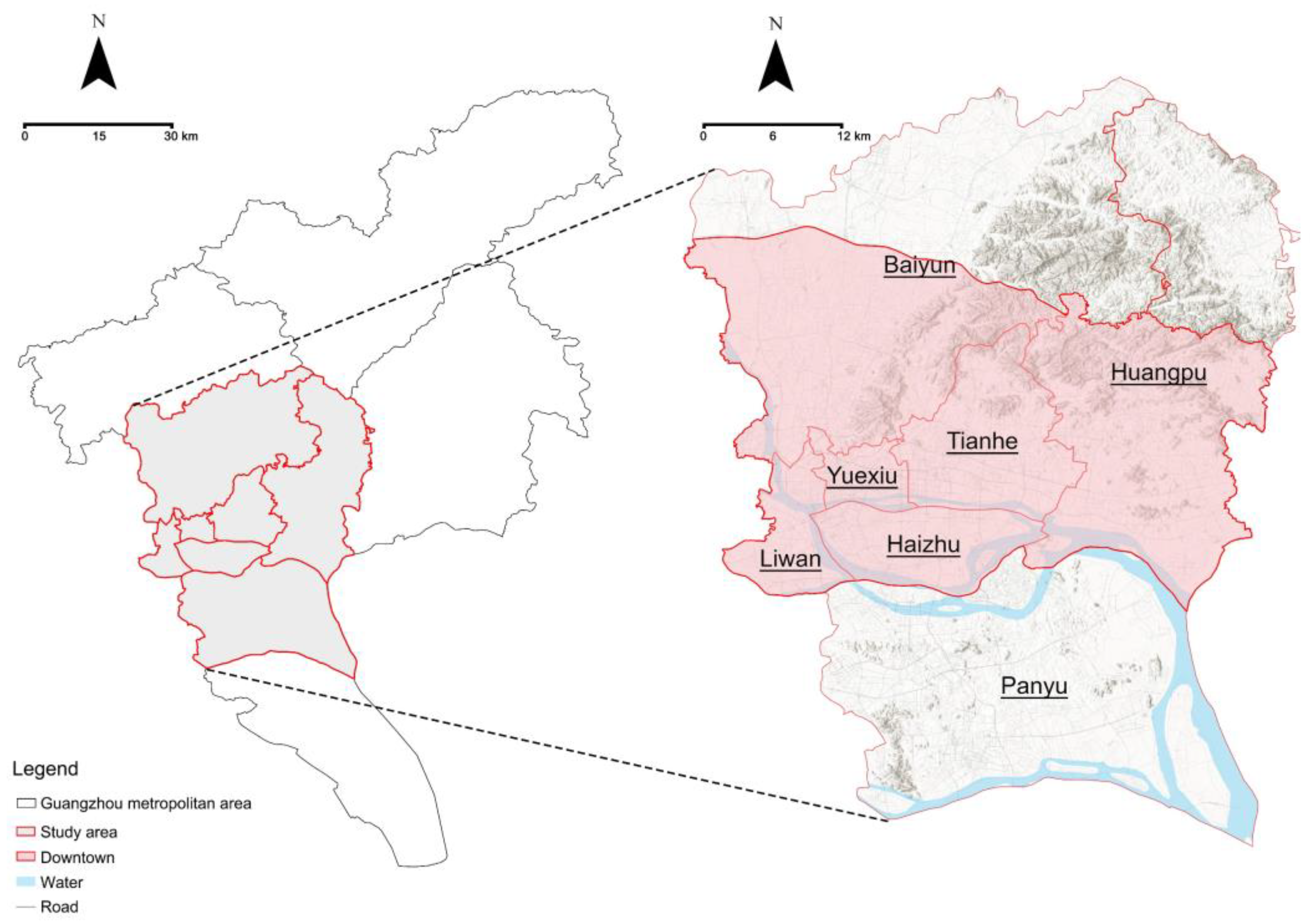
Figure 2.
Analytical framework. Inspired by Xu et al. [62].
Figure 2.
Analytical framework. Inspired by Xu et al. [62].
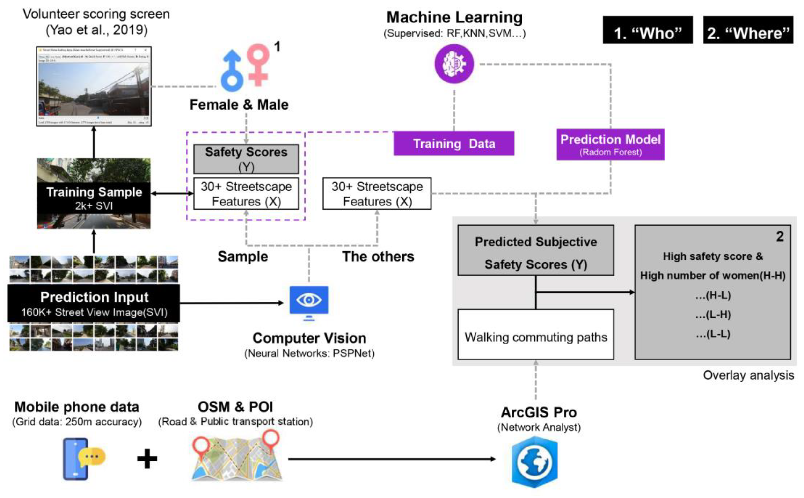
Figure 3.
Download SVIs by Baidu Map API. (a) A randomly selected sample of SVIs, (b) SVI download parameters were set, and (c) A typical SVI.
Figure 3.
Download SVIs by Baidu Map API. (a) A randomly selected sample of SVIs, (b) SVI download parameters were set, and (c) A typical SVI.
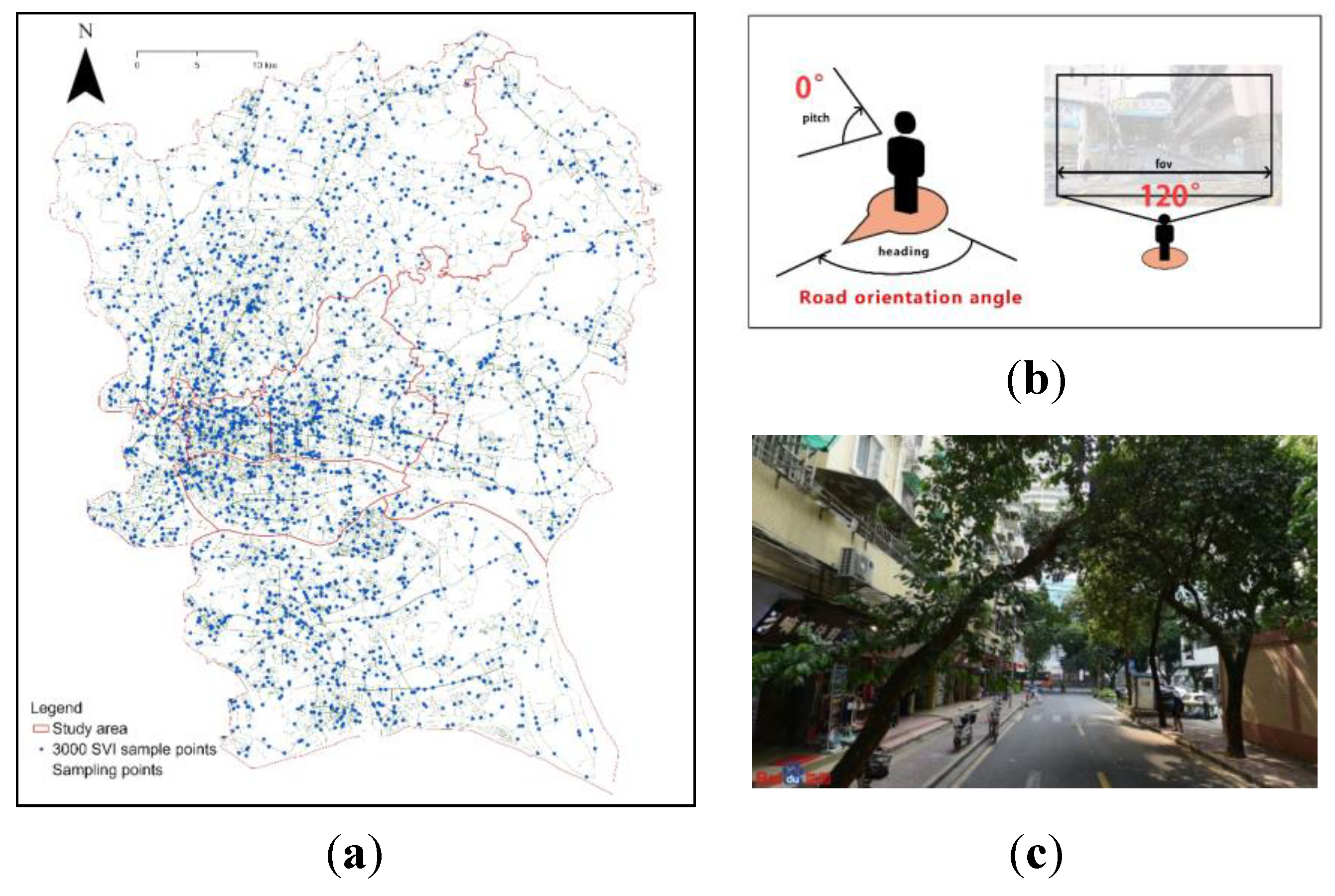
Figure 4.
Volunteers' (a) grouping and (b) scoring interface created by Yao et al. [63]. (* indicates 10 men asked to perceive as women).
Figure 4.
Volunteers' (a) grouping and (b) scoring interface created by Yao et al. [63]. (* indicates 10 men asked to perceive as women).
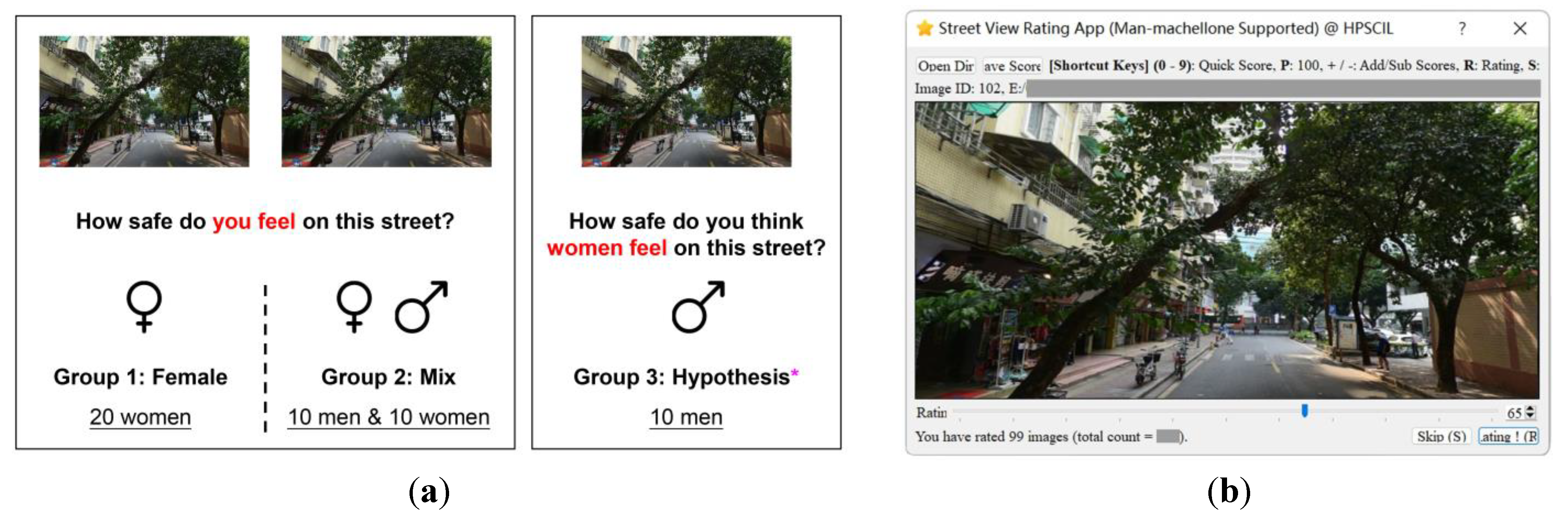
Figure 5.
Illustration of the commuting process.
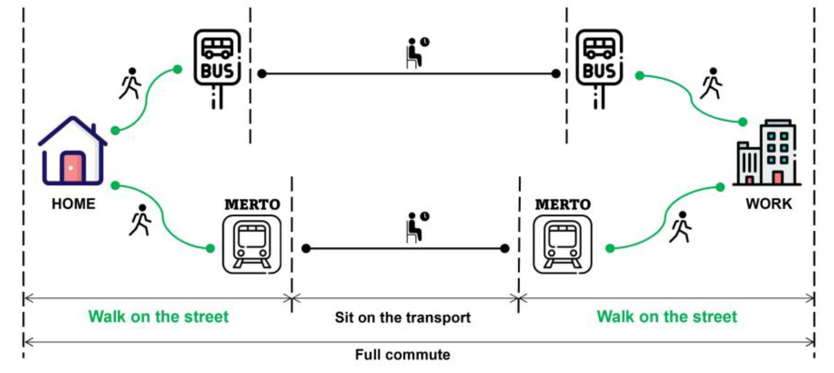
Figure 6.
Simulation of commuter paths: (a) metro station; (b) bus station. Map data sources: Esri, HERE, Garmin, FAO, NOAA, USGS, (c) OpenStreetMap contributors.
Figure 6.
Simulation of commuter paths: (a) metro station; (b) bus station. Map data sources: Esri, HERE, Garmin, FAO, NOAA, USGS, (c) OpenStreetMap contributors.
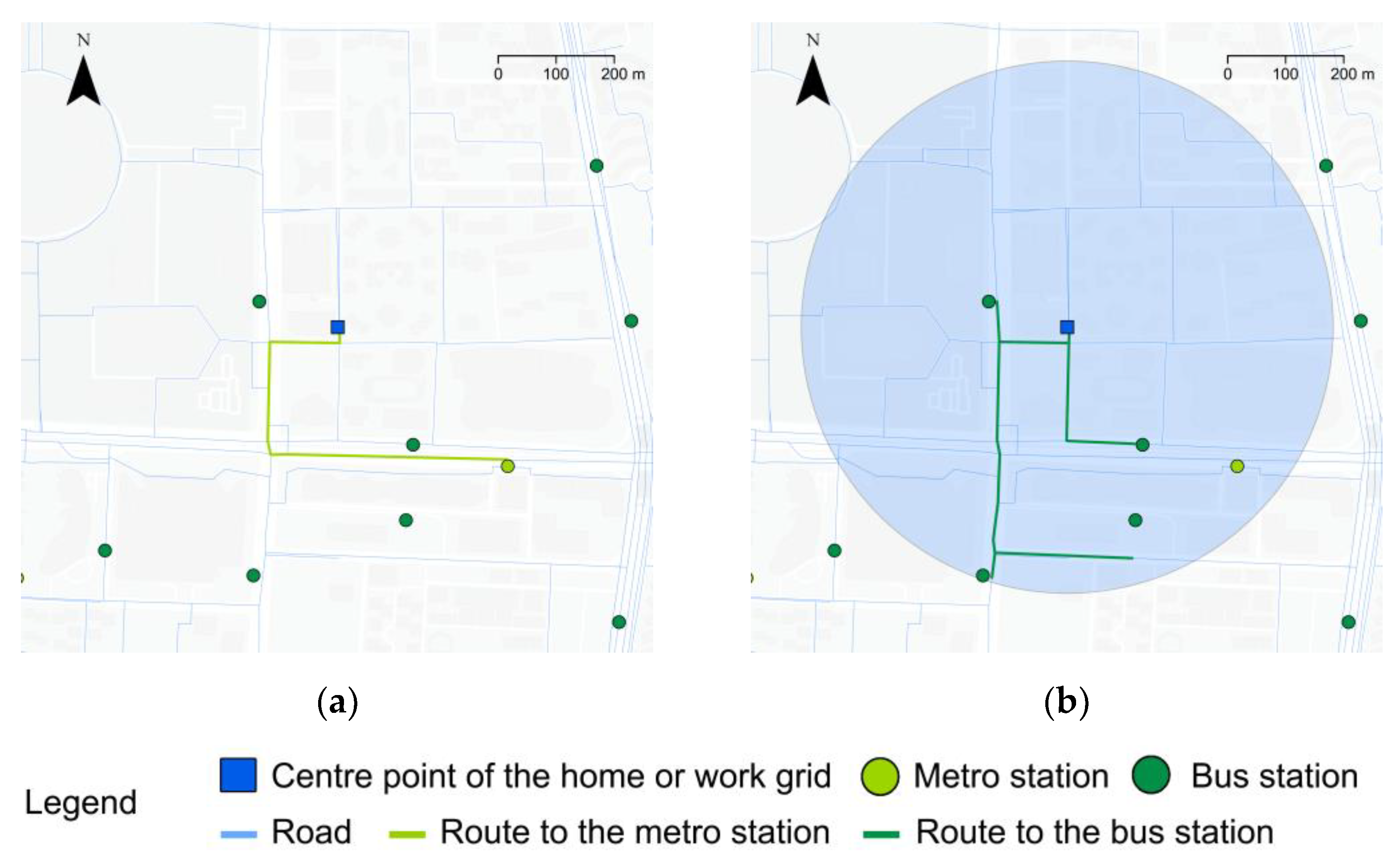
Figure 7.
Volunteer scoring results: (a) histogram; (b) histogram of segment scores.
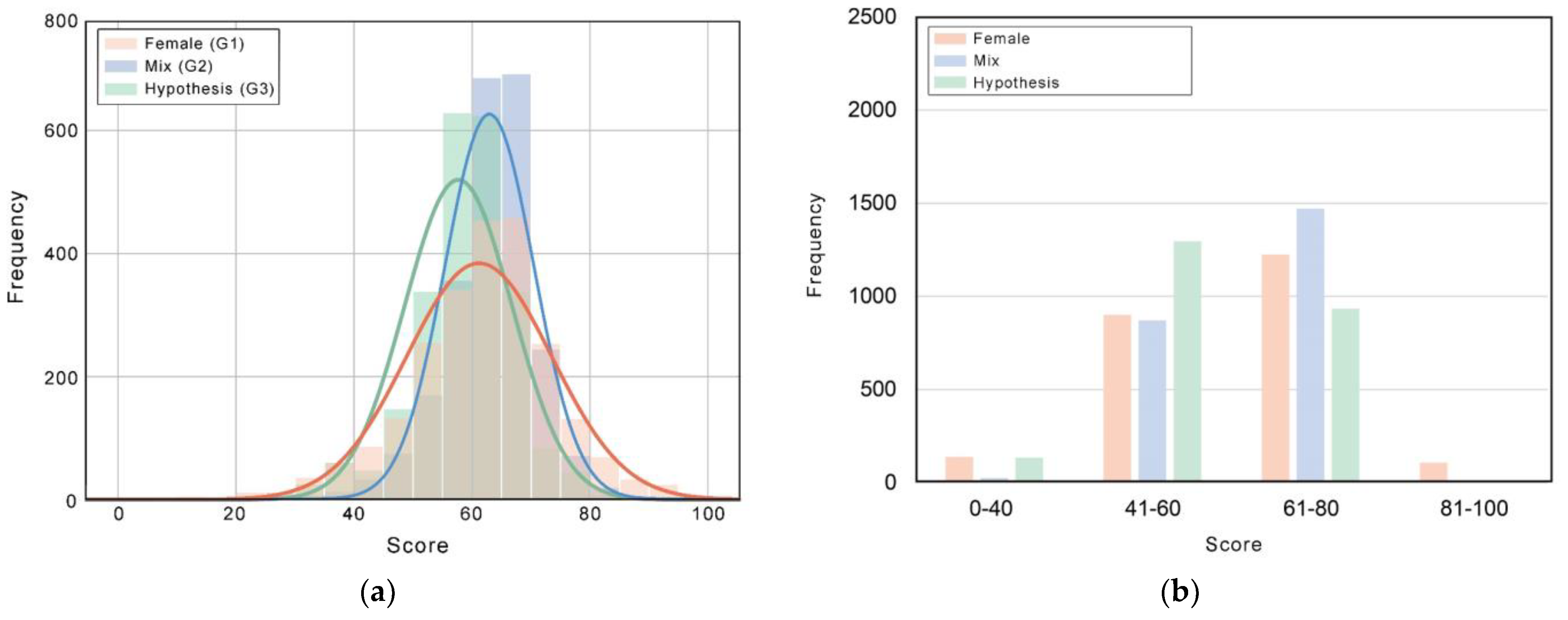
Figure 8.
Women's perceived safety score map. Map data sources: (c) OpenStreetMap contributors.
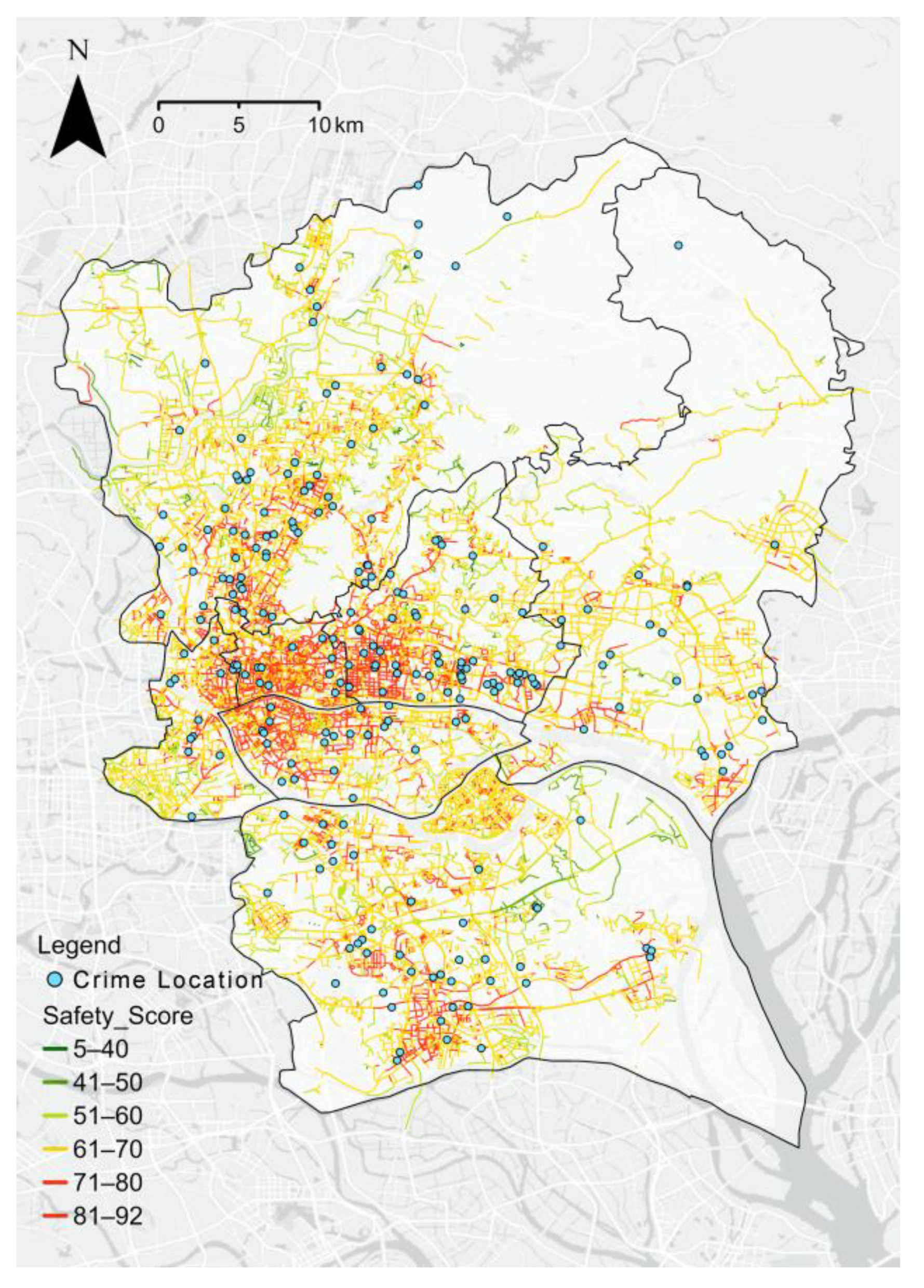
Figure 9.
Safety scores for different types of roads between downtown and suburban: (a) rural roads, (b) cycle paths, (c) internal roads, (d) urban feeder roads, (e) urban secondary roads, (f) footpaths, and (g) urban main roads.
Figure 9.
Safety scores for different types of roads between downtown and suburban: (a) rural roads, (b) cycle paths, (c) internal roads, (d) urban feeder roads, (e) urban secondary roads, (f) footpaths, and (g) urban main roads.
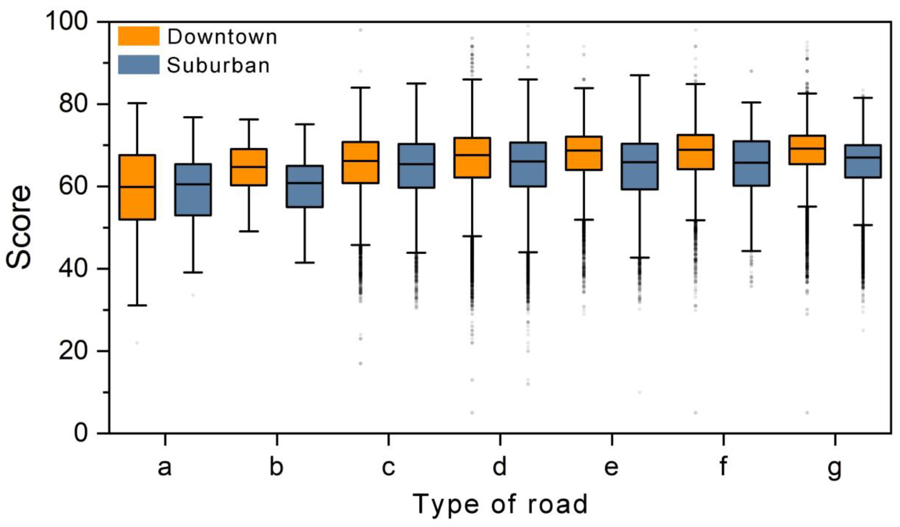
Figure 10.
Comparison of safety scores for all city street points and street points within 400 m of the crime location.
Figure 10.
Comparison of safety scores for all city street points and street points within 400 m of the crime location.
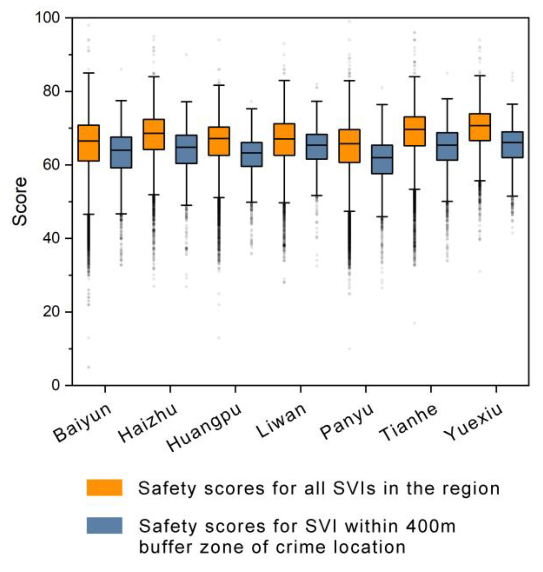
Figure 11.
Path and number of females on the path from their residence and work to public transport stops. Map data sources: (c) OpenStreetMap contributors.
Figure 11.
Path and number of females on the path from their residence and work to public transport stops. Map data sources: (c) OpenStreetMap contributors.
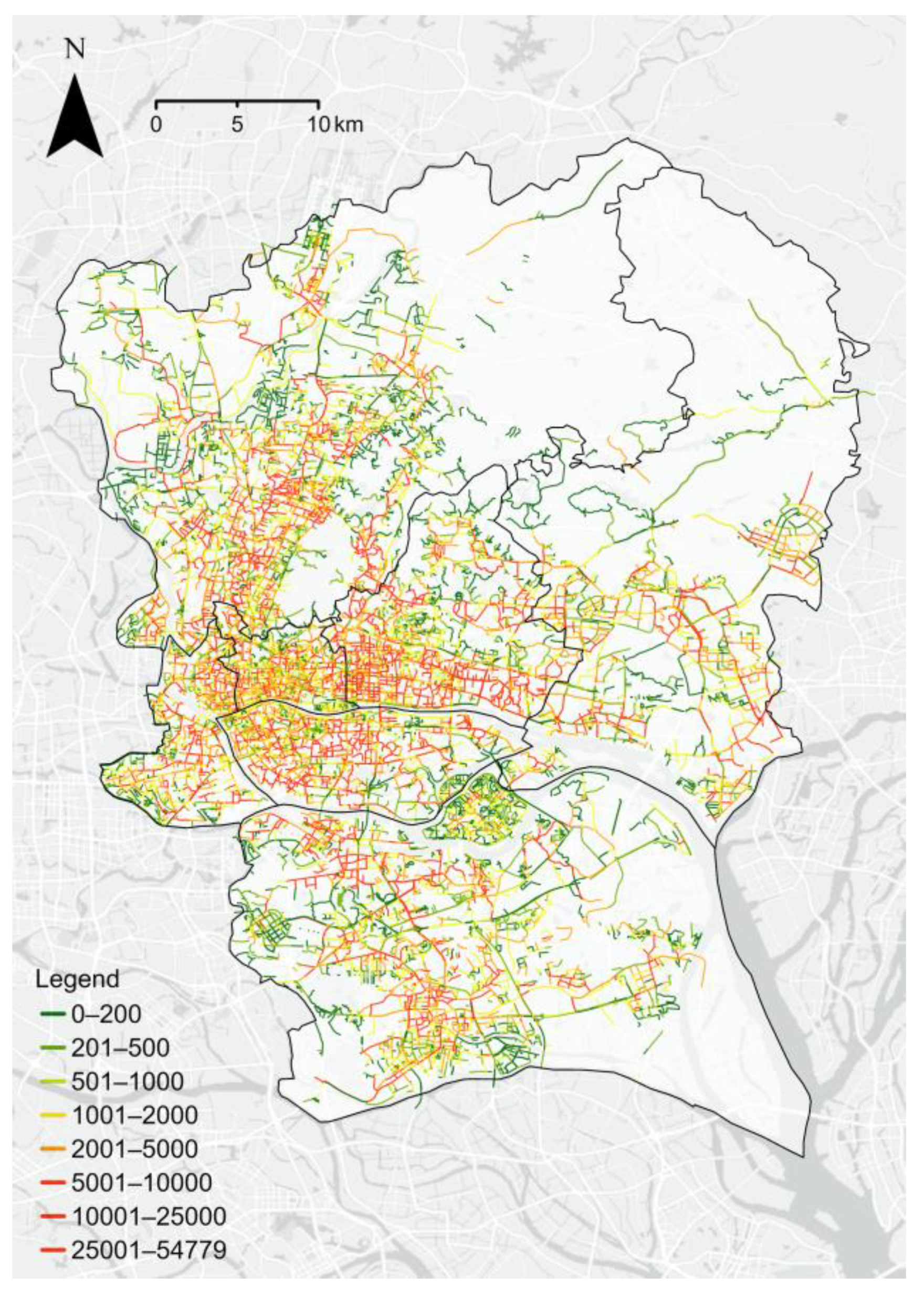
Figure 12.
Overlay of street safety scores and the number of females. Map data sources: (c) OpenStreetMap contributors.
Figure 12.
Overlay of street safety scores and the number of females. Map data sources: (c) OpenStreetMap contributors.
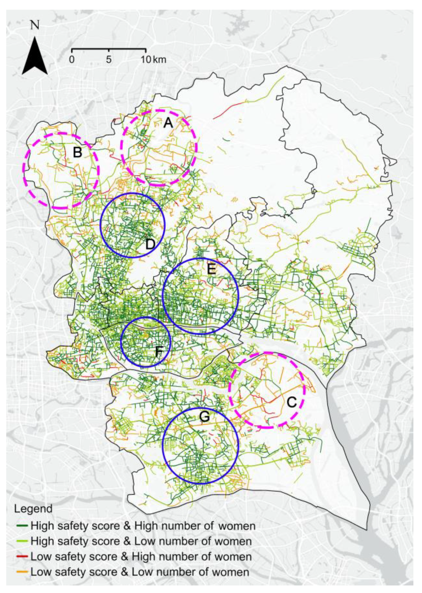
Figure 13.
Visual elements affecting perceived safety were analysed by multiple linear regression.
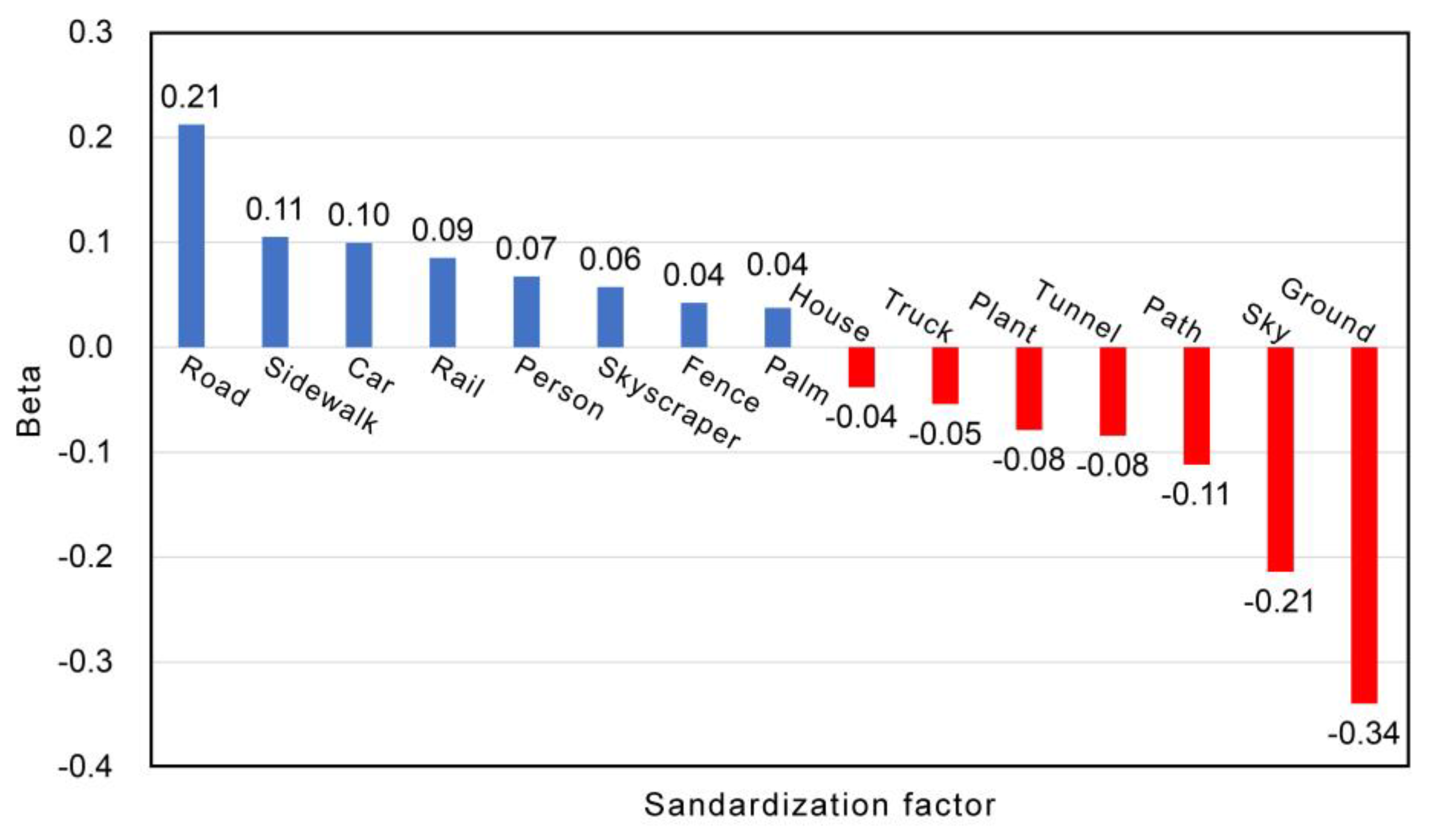

Table 1.
Examples of mobile phone location records.
| FID | Gender | Population weight | Home net_id |
Work net_id |
|---|---|---|---|---|
| 1 | Male | 5.654 | 21797 | 38258 |
| 2 | Female | 5.474 | 21797 | 21797 |
| 3 | Male | 4.982 | 22529 | 25701 |
| … | … | … | … | … |
| N | Female | 6.797 | 24966 | 27906 |
Table 2.
Performance of machine learning algorithms.
| Model | RMSE | MAE | |
|---|---|---|---|
| K-Nearest Neighbours (KNN) | 10.0 | 7.6 | |
| Support Vector Machine (SVM) | 9.2 | 6.9 | |
| Radom Forest (RF) | 8.8 | 6.5 | |
| Decision Tree (DT) | 11.2 | 7.6 | |
| Ordinary Least Squares (OLS) | 9.8 | 7.4 | |
| Gaussian Process Regressor (GPR) | 9.8 | 7.4 | |
| Voting Selection (VS) | 8.9 | 6.8 | |
| Adaptive Boost (ADAB) | 9.7 | 7.4 | |
| Bagging Regression (BR) | 9.2 | 6.9 | |
Table 3.
Four types of streets in terms of number, length, and proportion.
| Type | Number of streets | PCT | Street lengths (km) |
PCT | Mean lengths (m) |
|---|---|---|---|---|---|
| High safety score and High number of women |
16,908 | 47.1% | 2789.9 | 43.8% | 165.0 |
| High safety score and Low number of women |
15,053 | 41.9% | 2727.2 | 42.8% | 181.2 |
| Low safety score and High number of women |
1,050 | 2.9% | 155.2 | 2.4% | 147.8 |
| Low safety score and Low number of women |
2,895 | 8.1% | 692.7 | 10.9% | 239.3 |
| 1 | In some SVIs, the percentage of individual visual elements is extremely high because the camera is too close to certain types of elements. We have mainly eliminated such SVIs in our manual review. |
| 2 | Because there are multiple mobile signal operators in China, that operator needs to derive the population weights represented by each individual. |
| 3 | The O-D position is derived from daytime and nighttime residency data for a full month for each individual. |
| 4 | Since the platform for downloading mobile phone data has restrictions on the upload file size, the 250 × 250 m grid is already the maximum accuracy for urban-scale studies. |
| 5 | Due to the need to protect the privacy of the victim, the published crime cases will not contain information on the gender of the victim. Therefore, this study selects sex crime cases, in which the victims are almost all female. The data were obtained from 427 crime cases in Guangzhou City published by the Magistrate's Office and Beida Faber during 2002-2022, of which 387 cases were in the study area. |
Disclaimer/Publisher’s Note: The statements, opinions and data contained in all publications are solely those of the individual author(s) and contributor(s) and not of MDPI and/or the editor(s). MDPI and/or the editor(s) disclaim responsibility for any injury to people or property resulting from any ideas, methods, instructions or products referred to in the content. |
© 2023 by the authors. Licensee MDPI, Basel, Switzerland. This article is an open access article distributed under the terms and conditions of the Creative Commons Attribution (CC BY) license (http://creativecommons.org/licenses/by/4.0/).
Copyright: This open access article is published under a Creative Commons CC BY 4.0 license, which permit the free download, distribution, and reuse, provided that the author and preprint are cited in any reuse.


