
Submitted:
01 February 2022
Posted:
03 February 2022
Read the latest preprint version here
Abstract
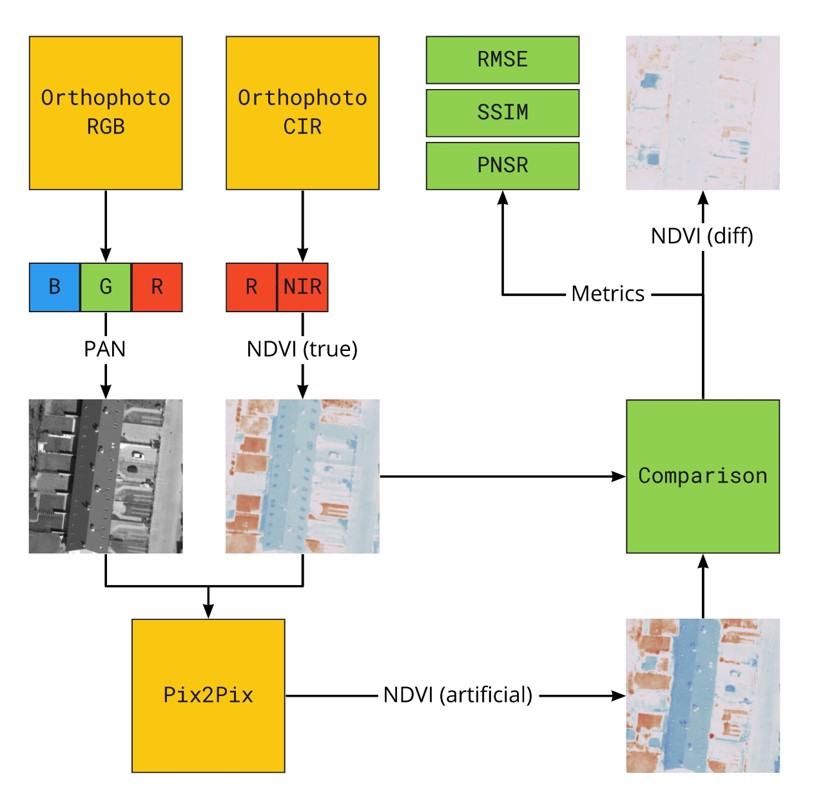
Generative adversarial networks (GAN) opened new possibilities for image processing and analysis. Inpainting, dataset augmentation using artificial samples or increasing resolution of aerial imagery are only a few notable examples of utilizing GANs in remote sensing. This is due to a unique construction and training process expressed as a duel between GAN components. In the following research, GAN has been applied to enhance panchromatic images with Normalized Difference Vegetation Index (NDVI). Panchromatic orthoimagery dataset with NDVI ground-truth labels was prepared by combining RGB and NIR orthophoto. The dataset was then utilized as input for a conditional generative adversarial network (cGAN) to perform an image-to-image translation. The main goal of the neural network was to generate an artificial NDVI channel for each processed 256px × 256px patch using only information available in the panchromatic imagery. The network achieved 0.9869 ± 0.0099 SSIM, 47.1635643 ± 4.0527963 PNSR and 0.0048023 ± 0.0018756 RSME on the test set. Perceptual evaluation was performed to verify the usability of the method when working with a real-life scenario. The research confirms that the structure and texture of the panchromatic aerial remote sensing image contains sufficient information for NDVI estimation for various objects of urban space. Even though these results can be used to highlight areas rich in vegetation and distinguish them from urban background, there is still room for improvement in terms of accuracy of estimated values.
Keywords:
generative adversarial networks
; remote sensing
; NDVI
; green areas
; orthophoto
; artificial datasets.
Copyright: This open access article is published under a Creative Commons CC BY 4.0 license, which permit the free download, distribution, and reuse, provided that the author and preprint are cited in any reuse.


