
Submitted:
08 April 2021
Posted:
09 April 2021
You are already at the latest version
Abstract
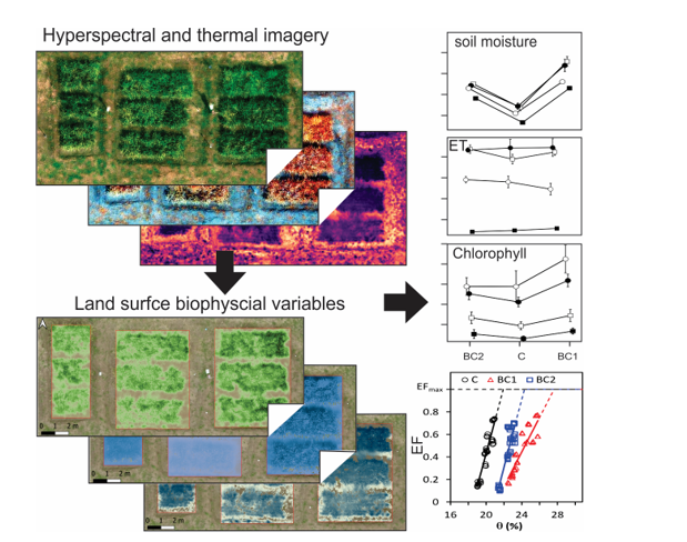
Low-cost miniature hyperspectral and thermal cameras onboard lightweight unmanned aerial vehicles (UAV) bring new opportunities for monitoring land surface variables at unprecedented fine spatial resolution with acceptable accuracy. This research applies hyperspectral and thermal imagery from a drone to quantify upland rice growth and water use efficiency (WUE) after biochar application in a Costa Rican dry region. The field flights were conducted over two experimental groups with bamboo biochar and sugarcane biochar amendments and one control group without biochar application. Rice canopy biophysical variables were estimated by inversion of a canopy radiative transfer model on hyperspectral reflectance. Variations in gross primary production (GPP) and WUE across treatments were estimated from the normalized difference vegetation index (NDVI), canopy chlorophyll content (CCC), and evapotranspiration. We found that GPP was increased by 41.9±3.4 % when using bamboo biochar and 17.5±3.4 % when using sugarcane biochar, which was probably due to higher soil moisture in the biochar-amended plots and led to significantly higher WUE by 40.8±3.5 % in bamboo biochar and 13.4±3.5 % in sugarcane biochar. This study demonstrated the use of hyperspectral and thermal imagery from drone to provide indicators for quantifying biochar effects on tropical dry cropland by integrating with ground point samples and physical models.
Keywords:
Unmanned aerial vehicle (UAV)
; hyperspectral and thermal imagery
; gross primary production (GPP)
; water use efficiency (WUE)
; biochar
Copyright: This open access article is published under a Creative Commons CC BY 4.0 license, which permit the free download, distribution, and reuse, provided that the author and preprint are cited in any reuse.


