
Submitted:
31 July 2020
Posted:
02 August 2020
You are already at the latest version
Abstract
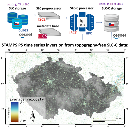
Sentinel-1 satellite system continuously observes European countries in a relatively high revisit frequency of 6 days per orbital track. Given the Sentinel-1 configuration, most areas in Czechia are observed every 1–2 days by different tracks in a moderate resolution. This is attractive for various types of analyses by various research groups. The starting point for processing is an original data provided by ESA, for interferometry (InSAR) this level is a Single Look Complex (SLC) data. This work represents advantages of storing data augmented to a specifically corrected level of data, SLC-C. The presented database contains Czech nation-wide Sentinel-1 data stored in burst units that have been preprocessed to the state of a consistent well-coregistered dataset of SLC-C. These are resampled SLC data with their phase values reduced by a topographic phase signature, ready for fast interferometric analyses (an interferogram is generated by a complex conjugate between two stored SLC-C files). The data can be used directly into multitemporal interferometry techniques, e.g. Persistent Scatterers (PS) or Small Baseline (SB) techniques applied here. A further development of the nation-wide system utilising SLC-C data would lead into a dynamic state where every new pre-processed burst triggers a processing update to detect unexpected changes from InSAR time series and therefore provide a signal for early warning against a potential dangerous displacement, e.g. a landslide, instability of an engineering structure or a formation of a sinkhole. An update of the processing chain would also allow use of cross-polarised Sentinel-1 data, needed for polarimetric analyses. The current system is running at a national supercomputing centre IT4Innovations in interconnection to the Czech Copernicus Collaborative Ground Segment (CESNET), providing fast on-demand InSAR results over Czech territories. A full nation-wide PS processing using data over Czechia has been performed in 2017, discovering several areas of land deformation. Its downsampled version and basic findings are demonstrated within the article.
Keywords:
Displacement measurement
; High performance computing
; Radar interferometry
; Synthetic aperture radar
Copyright: This open access article is published under a Creative Commons CC BY 4.0 license, which permit the free download, distribution, and reuse, provided that the author and preprint are cited in any reuse.


