
Submitted:
28 October 2026
Posted:
29 October 2026
You are already at the latest version
Abstract
National geospatial infrastructures increasingly connect Earth Observation (EO), geospatial artificial intelligence (GeoAI), interoperable services, and public-sector decision processes. However, an explicit method for assessing whether these technical functions operationalize the nine pathways of the United Nations Integrated Geospatial Information Framework (UN-IGIF) remains underdeveloped. This Communication develops a pathway-to-function-to-evidence assessment framework and applies it illustratively to the Rwanda Space Agency (RSA) GeoHub case. Using the UN-IGIF pathway definitions as normative criteria and the available GeoHub description as case material, we classify reported functions, map their institutional and technical dependencies, and identify the records required to substantiate operational performance and decision uptake. Worked mappings cover EO data stewardship, GeoAI processing, interoperable delivery, and sectoral decision workflows. The contribution is a transparent analytical procedure that distinguishes reported capabilities, proposed applications, and independently verified outcomes; it does not constitute an audit or quantitative impact evaluation. The framework offers a transferable basis for planning and evaluating EO-enabled geospatial infrastructures in emerging space ecosystems.
Keywords:
earth observation
; GeoAI
; geospatial artificial intelligence
; UN-IGIF
; rwanda space agency
; GeoHub
; national spatial data infrastructure
; satellite imagery
; geospatial governance
; decision support
1. Introduction
Geospatial information provides a common spatial reference for environmental monitoring, agricultural management, climate-risk analysis, and public investment [1,2]. Satellite Earth Observation provides repeated observations of land and environmental change, while advances in machine learning support extracting information from increasingly large optical, radar, and ancillary datasets[3,4]. However, the usefulness of a satellite-derived map for government decisions depends on more than model accuracy: datasets must be discoverable, interpretable, current, governed, and integrated with administrative workflows[5,6,7]
National Spatial Data Infrastructures (NSDIs) were developed to coordinate geographic data production, standards, and sharing [8,9,10]. Fragmented institutional mandates, discontinuous financing, uneven technical capacity, and systems optimized for data download rather than operational analytics can constrain their implementation [11,12]. These challenges motivate a shift in analytical emphasis from the existence of geospatial portals to the full information-production chain, from observation to validated indicators and their use in decision-making [5].
The United Nations Integrated Geospatial Information Framework (UN-IGIF) provides a country-led approach to this problem. Its nine strategic pathways span governance and institutions, policy and legal arrangements, finance, data, innovation, standards, partnerships, capacity and education, and communication and engagement[13,14]. The pathways are organized within governance, technology, and people domains and are intended to be applied together rather than treated as isolated technical requirements[15,16]
The Rwanda Space Agency (RSA), established in 2020, provides a relevant institutional context for examining the relationship between national space capability and geospatial services[17]. Available descriptive material portrays GeoHub as an RSA-associated environment intended to connect EO inputs, AI/ML processing, and sector-facing geospatial products
The present study treats that description as case material rather than as independent proof of deployment or performance.
This study makes a conceptual and methodological contribution rather than an empirical evaluation of GeoHub effectiveness. It asks: (RQ1) How can the nine UN-IGIF pathways be translated into observable EO/GeoAI infrastructure functions? (RQ2) Which documentary or technical evidence is required to distinguish a described capability from a verified operational outcome? (RQ3) How can these functions be traced to government decision workflows without presuming causal impact? The novelty lies in a replicable pathway–function–evidence–decision mapping that joins UN-IGIF institutional requirements with EO/GeoAI system assurance and decision traceability. GeoHub provides an illustrative national case; its implementation performance is not quantitatively assessed.
1.1. Linking the UN-IGIF to Operational Geospatial Infrastructure
The UN-IGIF provides the strategic conditions for nationally coordinated geospatial information management, but the framework is not itself a processing platform. Its implementation requires institutions and technical systems that translate strategic pathways into repeatable operational functions.
GeoHub is examined here as a potential implementation infrastructure: RSA provides an institutional convening and EO-capability anchor; satellite and ancillary datasets supply observations; GeoAI converts observations into spatial indicators; and shared geospatial services make those indicators available to public-sector users (Figure 1).
In this interpretation, the UN-IGIF supplies governance and accountability requirements, while GeoHub supplies a possible technical mechanism for executing them. Neither component is sufficient without the other.
The relationship is bidirectional rather than a simple technology-first sequence. The UN-IGIF can guide GeoHub data stewardship, interoperability, investment and skills priorities; conversely, GeoHub operational evidence can reveal where UN-IGIF pathways are effective or remain constrained. For example, a land-cover classification workflow can make Pathway 4 (Data) observable through provenance and update frequency, Pathway 5 (Innovation) through model reproducibility and validation, and Pathway 6 (Standards) through metadata and service interoperability. Whether the resulting map informs an agency decision also depends on Pathways 1–3 and 7–9: mandates, lawful access, recurrent funding, partnerships, technical capacity and communication. These are proposed evaluation linkages, not verified performance results.
1.2. GeoHub as an Implementation Accelerator: Mechanism and Testable Expectations
The central hypothesis is that shared EO ingestion, reproducible GeoAI pipelines and interoperable delivery can shorten the interval between new Earth observations and usable government information, thereby helping institutions put selected UN-IGIF pathways into practice. Acceleration should be defined operationally, not asserted from architecture alone through indicators such as acquisition-to-publication latency, percentage of datasets with standards-compliant metadata, frequency of validated product updates, cross-agency reuse, cost per maintained service and time from publication to a documented decision. A baseline, observation period, and data source are necessary before any improvement can be claimed.
This interpretation positions RSA as a possible technical integrator rather than the exclusive legal custodian of national geospatial information. For Geomatics, the analytical contribution is the explicit connection between geospatial infrastructure design, standards-based service delivery, institutional stewardship, and the records needed to evaluate public-sector use.
2. Materials and Methods
2.1. Case-Study Design and Evidence Boundaries
We conducted a structured conceptual case analysis. The normative source was the UN-IGIF nine-pathway framework and its published pathway definitions [6,13,14,15,16]; the case source was the GeoHub institutional and technical description available to the authors.
The unit of analysis was a proposed service chain: institutional coordination → EO inputs → GeoAI processing → interoperable GeoHub delivery → government decision workflow.
The case material was not supplemented by independently accessed system logs, source-code audits, stakeholder interviews, ground-truth datasets, signed interagency agreements, or decision records. Consequently, the exercise assesses conceptual correspondence and evidence requirements, not realized institutional maturity or impact.
The analytical procedure comprised five stepsFirst, we extracted explicit claims about mandates, datasets, processing, interfaces, institutional users, and intended decisions from the available case description. Second, we assigned each claim to a UN-IGIF pathway using the pathway’s published subject matter as the coding criterion (governance, law, finance, data, innovation, standards, partnerships, capacity, or engagement); a claim could map to more than one pathway when justified. Third, we identified an observable function and its minimum verification artifact, such as a dataset catalogue, model card, API test, signed agreement, or decision record. Fourth, we classified the claim as described, proposed, independently verified, or not assessable from the available material; no claim was classified as independently verified without a traceable supporting artifact. Fifth, we mapped the function to a specific government decision question and recorded missing evidence. Table 1, Table 2, Table 3 and Table 4 present the mapping rules, required artifacts, and candidate indicators. The procedure is transparent but was not independently double-coded; inter-rater reliability is therefore not claimed.
2.2. UN-IGIF Pathway Mapping
The UN-IGIF groups nine pathways into governance (1–3), technology (4–6), and people (7–9) as illustrated in Figure 2. We operationalize these domains through three corresponding analytical layers: institutional foundations; EO/GeoAI architecture and standards; and partnerships, human capacity, and decision uptake (Figure 2). A pathway is considered supported only when its corresponding evidence is available and traceable. Absence of evidence is not scored as evidence of absence; rather, it is coded as “not independently verified.”
2.3. EO–GeoAI–GeoHub Technical Reference Model
The technical assessment treats the GeoHub processing chain as four interacting layers. Layer A, observation inputs, may include optical imagery (e.g., Sentinel-2), radar imagery (e.g., Sentinel-1), ancillary geospatial layers, in-situ observations, and administrative records. Layer B, data engineering, encompasses ingestion, geometric and radiometric preprocessing where appropriate, cloud/shadow screening, co-registration, metadata management and provenance. Layer C, GeoAI, includes feature engineering, training/inference, independent validation, uncertainty estimation and model versioning. Layer D, delivery, includes geospatial products, application programming interfaces (APIs), dashboards and sector-specific decision interfaces. Figure 3 is a conceptual reference model derived from the source description; it is not an audited system diagram.
The available case description refers to multi-sensor EO, AI/ML processing, and API-oriented dissemination but does not include scene-level acquisition metadata, preprocessing configurations, model versions, independent reference samples, or measured service performance. We therefore used these elements to define the architecture and verification requirements, not to infer that the corresponding processes have been validated.
2.4. Assessment of Technical Verifiability
We assessed the verifiability of each described EO/GeoAI function against nine information categories: geography and observation period; sensor and product identifiers; preprocessing; target variable or class definition; model specification and tuning; spatially independent validation; accuracy or error and uncertainty; versioned code and parameters; and dissemination and recorded use. The absence of these records was coded as not independently verified. We did not compute classification accuracy, RMSE, service latency, or causal decision effects because the underlying observations were unavailable. Table 2 reports the resulting evidence-status assessment.
2.5. Institutional Maturity and Inference Rules
The available description also contains suggested maturity ratings for the nine pathways, ranging from 3.5 to 4.5 on a five-point scale. Because no scoring rubric, named raters, documentary audit trail, or uncertainty estimates accompanied those figures, we excluded them from quantitative analysis. The present findings are categorical pathway mappings, not measured maturity scores.
3. Mapping GeoHub and RSA to the UN-IGIF Pathways
The case-study analysis yields an integrated functional mapping of the source-described GeoHub model to the nine UN-IGIF pathways. The findings concern architectural and institutional alignment; they do not establish that the proposed services are fully deployed, consistently funded, or causally associated with public-sector outcomes.
3.1. Governance and Institutional Foundations (Pathways 1, 2 and 3)
The source presents RSA as the focal institution for the GeoHub initiative and attributes a coordinating role to its national space mandate. Such an institutional anchor could facilitate common EO processing services and shared geospatial infrastructure. However, the existence of a space agency does not automatically transfer legal custodianship of cadastral, agricultural, environmental or statistical records from the competent sector institutions. Operationalizing Pathway 1 therefore requires documented mandates and interagency decision rights.
Pathway 2 concerns the policies and legal arrangements under which data may be exchanged, reused and protected. The source describes standardized sharing protocols and interoperable delivery [6], but formal compliance requires evidence of agreements, licensing, access controls and relevant regulatory provisions.
Pathway 3 concerns recurrent financing. Serving several ministries can provide an economic rationale for a shared platform, but budget resilience, cost recovery and total cost of ownership cannot be inferred without expenditure and maintenance data.
3.2. Technical Infrastructure, Data and Innovation (Pathways 4, 5 and 6)
The technical core of the GeoHub concept is the transition from passive file hosting to an EO-to-analytics workflow. According to the source description, optical and radar satellite data and in-situ information can feed automated AI/ML processing, with outputs disseminated through geospatial services[18]. This is the principal connection between RSA space capability and government-facing geospatial intelligence.
In scientific terms, its significance depends on documented product lineage, repeatability, predictive accuracy, and fitness for the intended policy task.
Pathway 4 requires accessible and documented data assets. Pathway 5 addresses innovation, including cloud processing, ML inference, and automation. Pathway 6 requires standards and interoperability. A coherent implementation would include persistent dataset identifiers, common coordinate reference systems, discoverable metadata, versioned models, and tested APIs. The FAIR principles offer a complementary reference for machine-actionable data stewardship [7]; their citation here is a proposed evaluation benchmark, not proof that GeoHub currently satisfies all FAIR requirements.
The case description identifies crop classification, soil-related indicators, and land-cover change as illustrative GeoAI products. In the absence of dataset identifiers and independent validation records, we coded these as candidate applications rather than observed quantitative outputs.
3.3. People, Partnerships and Communication (Pathways 7, 8 and 9)
Partnerships, technical skills and accessible communication determine whether EO products reach operational users. The source describes collaborations, capacity-building activities and dashboard-oriented communication. Under Pathway 7, the relevant empirical evidence would include joint product specifications, co-development records and shared validation procedures. Under Pathway 8, evidence would include training completion, staff roles and maintenance capabilities. Under Pathway 9, the decisive test is not dashboard availability but traceable use of outputs in a government process.
3.4. Cross-Sector Government Decision Workflows
The source identifies agriculture, environment, disaster risk, natural capital accounting and urban planning as possible beneficiary sectors. These use cases demonstrate the breadth of the proposed GeoHub service model but should not be conflated with independently documented impact. Table 3 distinguishes potential EO/GeoAI products from decision questions and validation evidence. The relevant government outcome is a recorded action or decision informed by a sufficiently accurate and timely product not the production of a map in isolation.
Worked pathway mapping (illustrative, not an audited deployment): For a proposed land-cover-change service, an EO scene inventory and documented update schedule would provide evidence for Pathway 4 (Data); a versioned classification workflow and independent accuracy assessment would support Pathway 5 (Innovation); a discoverable metadata record and tested geospatial API would support Pathway 6 (Standards). A sector-agency product specification and agreed validation responsibilities would relate to Pathway 7 (Partnerships), while a dated planning or restoration decision citing the released map would be required to substantiate Pathway 9 (Communication and Engagement). The available case description identifies the application category but does not supply these complete artifacts. Therefore, the mapping demonstrates how the framework is applied, not that the associated pathways have been achieved.
3.5. Evidence Matrix and Measurable Performance Indicators
A useful assessment must separate EO model performance, infrastructure performance and institutional outcomes. Table 4 proposes indicators and source records that would allow a future GeoHub evaluation to test each link in the chain. No observed values, baseline improvements, or causal effects are asserted here.
4. The “Leapfrogging” Model of Centralized Space Frameworks
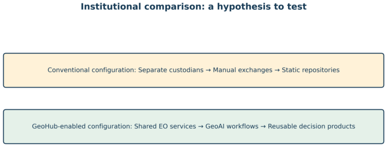
The case motivates a testable “leapfrogging” proposition: a national space agency might integrate shared EO infrastructure and AI processing more quickly than fragmented geospatial delivery arrangements. This is a conceptual hypothesis, not an observed comparative advantage. Testing it would require comparable processing, cost, reliability, reuse, and decision-uptake records across institutional configurations.
Figure 4.
Two idealized geospatial delivery configurations. This is a hypothesis-generating comparison, not an empirical performance comparison.
Figure 4.
Two idealized geospatial delivery configurations. This is a hypothesis-generating comparison, not an empirical performance comparison.
4.1. RSA as an Institutional Anchor, Not a Substitute for Sector Mandates
An RSA-centered platform can provide common technical services while authoritative sector institutions retain their legal responsibilities and domain expertise. This division is especially important for official statistics, environmental accounts and regulated datasets. The UN-IGIF makes the interaction between governance, technology and people explicit [6]. A credible institutional design should therefore document decision rights, data stewardship, funding responsibilities and mechanisms for correcting erroneous products.
4.2. From Satellite Pixels to Decisions: The Role of GeoAI
GeoAI is not synonymous with an automatically actionable product. EO models generate predictions subject to spatial, temporal, and sampling uncertainty. Decision readiness additionally requires semantic clarity, confidence estimates, ground validation, transparent refresh schedules, and communication appropriate to the user. The GeoHub model is most compelling when framed as an auditable pipeline that connects satellite observations to a decision record. Future evaluations should measure the interval from acquisition to validated product and from product delivery to documented government action.
4.3. Natural Capital Accounting as an Illustrative Integration Pathway
Natural capital accounting is a useful example because satellite-derived ecosystem extent and condition measures can contribute to environmental-economic accounting. The System of Environmental-Economic Accounting Ecosystem Accounting (SEEA EA) provides an international statistical framework [20].
However, EO-derived ecosystem layers alone do not establish ecosystem-service values or completed national accounts; accounting requires agreed classifications, ecological and economic methods, and validation by the competent statistical and sector agencies. GeoHub should therefore be described as a potential EO information provider for such workflows, unless operational accounting evidence is supplied.
4.4. Transferability, Risks and Limitations
The model may be relevant to other emerging space ecosystems where EO capabilities develop faster than institutional arrangements for sustained geospatial services. Transferability depends on statutory mandates, existing mapping institutions, procurement arrangements, cloud and connectivity costs, national technical capacity and demand from sector users. Centralized technical infrastructure may reduce duplication, but it can also create concentration risk and dependence on specialized personnel or vendors. The case does not currently establish which configuration performs better.
The principal limitation is the absence of independent platform access, interviews, system logs, source code, validated EO/GeoAI products, technical benchmarks, and decision records. Accordingly, this Communication presents a conceptual assessment method illustrated by one institutional case, not a verified evaluation of GeoHub operations. Future empirical work can apply the proposed coding rules to auditable artifacts and at least one end-to-end service, while testing whether the framework discriminates meaningfully among levels of implementation.
4.5. Translating Nine Strategic Pathways into Measurable GeoHub Operations
The strongest interpretation of GeoHub’s contribution to the UN-IGIF is as a common implementation layer that can make policy commitments measurable in technical workflows. Under governance and institutions (Pathway 1), evidence would include agreed roles for RSA and data-producing ministries. Under policy and legal arrangements (Pathway 2), evidence would include documented sharing permissions, licensing, and safeguards for sensitive layers. Under finance (Pathway 3), it would include recurring budgets for imagery access, computing, validation and maintenance. These requirements shape whether a GeoAI service can remain available after a project ends.
For the technology pathways, GeoHub could operationalize data (Pathway 4) through traceable satellite acquisitions, quality flags, catalogue completeness and versioned geospatial layers; innovation (Pathway 5) through repeatable model pipelines, documented training data and reproducible evaluation; and standards (Pathway 6) through shared metadata, coordinate reference systems, classification definitions and tested interfaces. For the people pathways, partnerships (Pathway 7) require jointly agreed production and acceptance criteria; capacity and education (Pathway 8) require staff able to retrain, evaluate and maintain models; and communication and engagement (Pathway 9) require accessible products whose limitations are clear to decision-makers. These links form an evaluation matrix, not a claim that all pathways have reached a particular maturity level.
4.6. What Would Demonstrate That GeoHub Accelerates UN-IGIF Implementation?
An acceleration claim should be evaluated against a defined counterfactual or at least a before-and-after baseline. A defensible design would select one recurring EO service, record its existing acquisition, processing, validation, and dissemination steps, and compare those records with a documented GeoHub-enabled workflow over comparable reporting periods. Outcome measures should include median turnaround time, completeness of metadata, independent accuracy, service availability, number of distinct institutional consumers, and documented decisions referencing the product. Observed changes should be interpreted alongside confounders such as improved satellite coverage, staffing, procurement, and policy reforms.
For example, an agricultural monitoring service might combine Sentinel optical and radar observations with administrative boundaries and field reference samples to generate seasonal crop indicators. Its scientific validity would depend on specified preprocessing, training and test separation, class-specific errors, and temporal transfer tests. Its UN-IGIF contribution would depend on who authorizes the product, whether agencies can reuse it under consistent standards, and whether the indicators inform a traceable planning decision. Without those records, the example remains a proposed evaluation design rather than an operational result.
The contribution to geomatics research is an explicit, transferable assessment procedure that connects national geospatial governance with EO/GeoAI processing, interoperable infrastructure, and evidence of public-sector use. It extends pathway-level policy interpretation by defining operational units of analysis, observable verification artifacts, and decision-traceability criteria. Its value is methodological rather than a demonstrated claim that centralized space agencies outperform alternative arrangements.
4.7. From Earth Observation Products to Accountable Government Decisions
Government decision-making is not the automatic endpoint of an EO processing pipeline. A decision-ready GeoHub product needs a defined user and decision threshold, documented uncertainty, temporal relevance, a mechanism for feedback and an audit trail connecting the version of the geospatial output to the decision record. This is especially important where false positives or missed changes could influence resource allocation, disaster warnings or regulatory action. Human review, sector expertise and administrative evidence should complement model predictions rather than be displaced by them.
The proposed value chain therefore has two feedback loops. A technical loop returns reference observations and user-reported errors to model validation and retraining. An institutional loop returns evidence of uptake, delays and disputes to the UN-IGIF implementation process, where mandates, standards, budgets and skills plans can be adjusted. Such feedback makes GeoHub more than a data portal in conceptual terms, but its effectiveness remains an empirical question that requires operational records.
4.8. Scientific Contribution and Boundary Conditions
The potential contribution to remote-sensing scholarship lies in linking validated EO/GeoAI product engineering with national-scale geospatial governance. The proposed framework is transferable as a set of assessment questions, not as proof that centralized space agencies outperform other institutional models. Future work should compare multiple service types, assess error propagation from imagery to decision indicators, quantify processing costs and document how standards and custodianship arrangements affect reuse. This preserves the original leapfrogging hypothesis while identifying the evidence necessary to test it.
5. Conclusions
This study examines the operationalization of the United Nations Integrated Geospatial Information Framework (UN-IGIF) through the institutional and technical relationship between the Rwanda Space Agency (RSA), Earth Observation (EO), GeoAI, and the GeoHub infrastructure. Its central argument is that a national space agency can contribute to the UN-IGIF not only by acquiring satellite imagery, but by organizing a sustained chain from observations and geospatial analysis to interoperable information services and government decision-making. Within this chain, the UN-IGIF provides the governance, policy, financial, data, innovation, standards, partnerships, capacity, and engagement pathways, while GeoHub represents a potential operational mechanism through which those pathways can be translated into services.
The establishment of a national space agency can be particularly consequential for countries developing their geospatial ecosystems. A dedicated agency can concentrate specialized EO and AI competencies, coordinate access to satellite-derived data, maintain common processing infrastructure, and serve as a technical interface between national institutions and international space partners. In the Rwanda case, the RSA–GeoHub model illustrates how such an institution may reduce duplication in technical workflows, promote shared standards, and make geospatial products more accessible to sector agencies. These are potential contributions to UN-IGIF implementation rather than automatic outcomes of institutional centralization: effective custodianship of authoritative sector datasets, data-sharing authority, and policy decisions must remain grounded in the mandates and agreements of the responsible institutions.
The proposed contribution extends across the nine UN-IGIF strategic pathways. Under governance and institutions, RSA can convene cross-sector technical coordination; under policy and legal arrangements, it can support implementing agreed data-access and reuse rules; and under financial sustainability, shared EO services may offer an alternative to isolated project-based systems. Under data, innovation, and standards, GeoHub can connect multi-sensor observations, documented GeoAI workflows, quality assurance, metadata, and interoperable delivery interfaces. Through partnerships, capacity, and communication, the agency can build national technical expertise, connect research and operational institutions, and translate complex satellite-derived outputs into decision-relevant products. The resulting value lies in the integration of these pathways: technically accurate maps alone do not establish a functioning national geospatial ecosystem unless institutions can trust, exchange, maintain, and use them.
At the level of public value, this integrated model offers a route from EO-derived evidence to practical decisions in agricultural monitoring, environmental management, disaster-risk assessment, spatial planning, and natural capital accounting. The expected contribution is faster production and wider reuse of consistent geospatial intelligence, alongside clearer traceability from source observations and model outputs to government-facing indicators. Demonstrating such effects requires evidence beyond the conceptual architecture, including validated EO/GeoAI products, documented data-sharing arrangements, service-use records, operational costs, and examples of decisions informed by GeoHub outputs. The present case does not establish quantified improvements in model accuracy, processing speed, financial efficiency, or policy outcomes, and these should not be inferred from the institutional design alone.
More broadly, the Rwanda case suggests that national space agencies may act as implementation enablers for the UN-IGIF in emerging space ecosystems by linking space capabilities with whole-of-government geospatial information management. The transferable lesson is not that every country should centralize geospatial authority within a space agency, but that implementation benefits from a clearly mandated technical integrator, accountable data stewardship, interoperable infrastructure, and sustained institutional capacity. Future research should test this proposition through auditable pathway assessments and at least one end-to-end operational EO/GeoAI use case, measuring both technical performance and actual uptake by government institutions. In this sense, RSA and GeoHub offer a relevant framework for investigating how national investment in space capabilities can support implementation of the UN-IGIF and strengthen evidence-based public decision-making.
Author Contributions
Gaspard Twagirayezu, Toussaint Maniriho, and Georges Kwizera contributed to the conception and design of the study. preparation, and writing this manuscript were performed by Yves Hategekimana and Valentine Mukanyandwi revised and formatted the manuscript.
Funding
This research received no external funding.
Acknowledgments
We would like to express our sincere gratitude to the Agence Française de Développement (AFD) for its financial support and valuable contribution to the GeoHub Project, which has been instrumental in its development and operationalization.
Conflicts of Interest
The authors declare no conflicts of interest.
Abbreviations
The following abbreviations are used in this manuscript:
| RSA | Rwanda Space Agency |
| MAE | Mean Absolute Error |
| RMSE | Root Mean Squared Error |
| EO | Earth Observation |
| GeoAI | Geospatial Artificial Intelligence |
| UN-IGIF | United Nations Integrated Geospatial Information Framework |
| AI/ML | Artificial Intelligence/Machine Learning |
| RQ1 | Research Question 1 |
| RQ2 | Research Question 2 |
| RQ3 | Research Question 3 |
| NSDI | National Spatial Data Infrastructures |
| APIs | Application Programming Interfaces |
| AFD | Agence Française de Développement |
References
- Thakuri, S. Integrating geospatial technologies in climate-smart agriculture planning and management: A review focused on South Asia APN Science Bulletin 2025. [CrossRef]
- Hossain, M.K. An Artificial Intelligence Integrated Geospatial Decision-Support Framework for Scenario-Based Climate-Adaptive Land-Use Optimization and Environmental Risk Reduction American Journal of Data Science and Analytics 2026. 7, 06, 425–483. [CrossRef]
- Persello, C.; et al. Deep learning and earth observation to support the sustainable development goals: Current approaches, open challenges, and future opportunities. IEEE Geosci. Geomat. Mag. 2022, 10(2), 172–200. [Google Scholar] [CrossRef]
- Li, Y.; Xiao, X. Integrating geospatial technologies in climate-smart agriculture planning and management: A review focused on South Asia APN Science Bulletin 2025, 25(16), 4991.
- Secretariat, U. Integrated Geospatial Information Framework: Committee of Experts on Global Geospatial Information Management, 12th session note/by the Secretariat. New York, 3-5 August 2022; 2022. [Google Scholar]
- UN-IGIF. Quick Reference Guide: UN-IGIF Nine Strategic Pathways. September 2020. Available online: https://ggim.un.org/UN-IGIF/documents/UN-IGIF_Quick_Reference_Guide.pdf.
- Wilkinson, M.D.; et al. The FAIR Guiding Principles for scientific data management and stewardship Scientific data 2016, 3(1), 160018.
- Council, N.R.; et al. Toward a coordinated spatial data infrastructure for the nation; National Academies Press, 1993. [Google Scholar]
- Sîrbu, R.; Cujbă, V.; Corman, I. The importance of national spatial data infrastructures in the context of the geographic information globalization. In ConsGeoCad, the first edition; 2024. 2025. [Google Scholar]
- Bello, I. Harnessing national geospatial data infrastructure and integrated geospatial information framework for good governance and national security International Journal of Space Technology Management and Innovation 2024. 1, 140–163.
- Ahmad, M.; Ali, A. A review of governance frameworks for national spatial data infrastructure Innovation, strategy, and transformation frameworks for the modern enterprise 2023, 186–207. [CrossRef]
- Authority, N.L. Rwanda Spatial Data Infrastructure. 2021. Available online: https://geodata.rw/portal/home/index.html.
- Scott, G. A national strategic geospatial information framework to support the implementation of the sustainable development goals (SDGs). Doctoral diss. 2020. Available online: https://minerva-access.
- Grant, V. Factors Influencing National Geospatial Information Management Adoption in Small Island Developing States; The University of North Carolina at Charlotte, 2025. [Google Scholar]
- Manga, A.; et al. Evaluating the Strategic Pathways of Senegal’s National Spatial Data Infrastructure Using the United Nations Integrated Geospatial Information Framework (UN-IGIF) ISPRS Int. J. Geo-Inf. 2026, 15(9), 407. [CrossRef]
- Utama, I.; Sutanta, H. A Model for Implementing the UN-IGIF in Geospatial Information Infrastructure Development for Indonesian Local Governments International Journal of Geoinformatics 2025, 21(6), 62–78. [CrossRef]
- Rwanda Space Agency. 2026. Available online: https://space.gov.rw/about-us.
- Hategekimana, Y.; et al. Modeling Flood Susceptibility in Rwanda Using an AI-Enabled Risk Mapping Tool Earth 2026. 7(2), 53. [CrossRef]
- Wang, Z. Space ai: Leveraging artificial intelligence for space to improve life on earth arXiv 2025, arXiv:2512.22399. [CrossRef]
- Nations, U. System of Environmental-Economic Accounting—Ecosystem Accounting (SEEA EA). 2021. Available online: https://seea.un.org/en/methodology/ecosystem-accounting?trk=article-ssr-frontend-pulse_little-text-block.
Figure 1.
Central research logic. The arrows represent the analytical sequence evaluated in this paper, not proof of a completed causal chain.
Figure 1.
Central research logic. The arrows represent the analytical sequence evaluated in this paper, not proof of a completed causal chain.
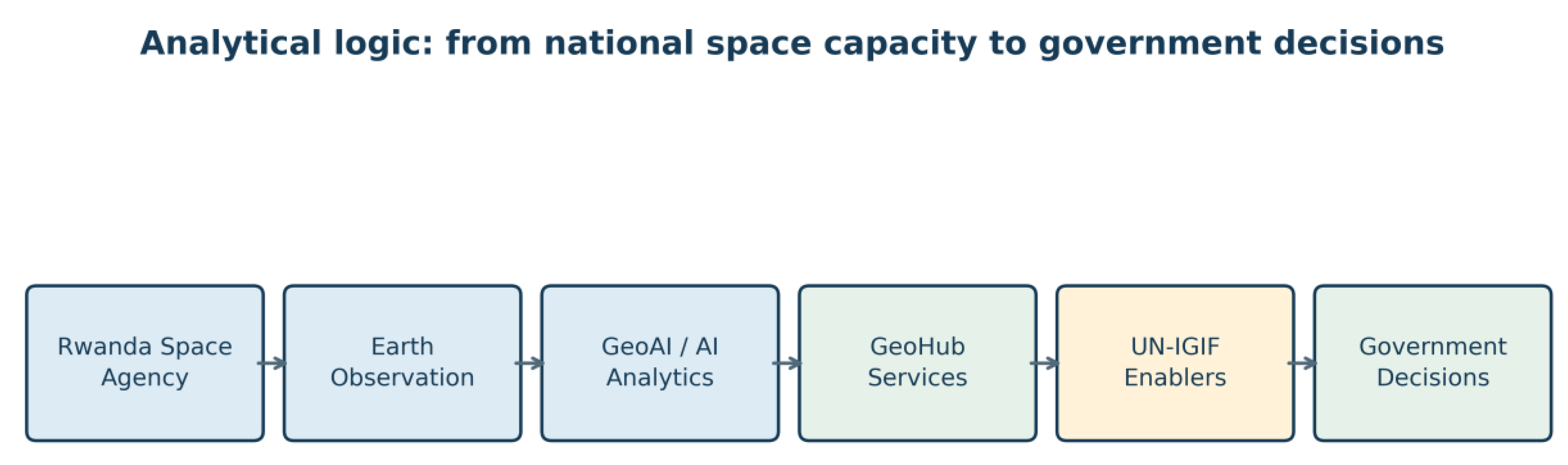
Figure 2.
UN-IGIF pathways used as the analytical coding structure for the GeoHub case; conceptual synthesis based on UN-IGIF [6] and the case description.
Figure 2.
UN-IGIF pathways used as the analytical coding structure for the GeoHub case; conceptual synthesis based on UN-IGIF [6] and the case description.
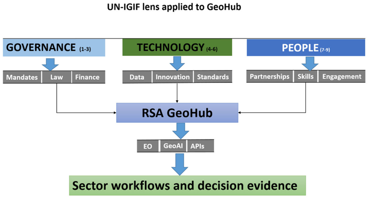
Figure 3.
EO-to-government information processing chain for evaluating GeoHub. Dashed implementation claims are deliberately avoided; each module requires system-level verification.
Figure 3.
EO-to-government information processing chain for evaluating GeoHub. Dashed implementation claims are deliberately avoided; each module requires system-level verification.
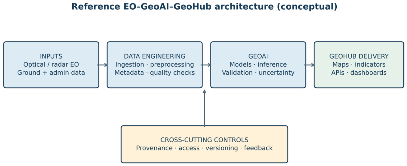

Table 1.
UN-IGIF pathway mapping and minimum verification requirements.
| Pathway | GeoHub / RSA question | Minimum verification |
|---|---|---|
| 1. Governance and Institutions | Who coordinates and who remains the data custodian? | Legal mandates; institutional role matrix |
| 2. Policy and Legal | How is data access authorized? | Signed agreements; licensing and privacy rules |
| 3. Financial | How are recurrent EO services funded? | Approved budget; cost and maintenance records |
| 4. Data | Are EO and ancillary inputs documented? | Catalogue; provenance; temporal/spatial metadata |
| 5. Innovation | Are GeoAI pipelines reproducible? | Model cards; code/version records; tests |
| 6. Standards | Are services interoperable? | API specifications; standards compliance tests |
| 7. Partnerships | Are sector workflows jointly governed? | Work plans; institutional records |
| 8. Capacity and Education | Can staff operate and validate pipelines? | Training and competency records |
| 9. Communication and Engagement | Do agencies use products in decisions? | Usage logs; decisions citing products |
Table 2.
Minimum technical evidence for publishable EO/GeoAI claims.
| Stage | Required reporting | Current evidence status |
|---|---|---|
| EO acquisition | Sensor, product, date, resolution, footprint, licensing | Sensor families named; acquisition metadata missing |
| Preprocessing | Corrections, masks, co-registration, compositing | Not independently documented |
| GeoAI inference | Model architecture, training data, split, versions | AI/ML referenced; implementation details missing |
| Validation | Independent reference, sampling, confusion matrix/error | No verified quantitative results supplied |
| Service delivery | Dataset identifiers, API tests, latency, uptime | APIs described; operational logs unavailable |
| Government uptake | User agency, decision record, date, product used | Applications proposed; decisions not audited |
Table 3.
Decision-oriented Geo Hub application and validation matrix.
| Government domain | Candidate EO/GeoAI product | Decision context | Evidence required |
|---|---|---|---|
| Agriculture | Crop extent; vegetation anomalies; seasonal monitoring | Targeting extension and field assessment | Field samples; temporal accuracy; decision records |
| Environment | Land-cover change; degradation indicators | Restoration and monitoring priorities | Reference data; change uncertainty; adopted plans |
| Disaster risk | Exposure overlays; event footprints | Risk screening and response prioritization | Event validation; warning/decision logs |
| Natural capital accounting | Ecosystem extent and condition inputs | Statistical compilation and environmental reporting | NISR/sector reconciliation; SEEA methodology |
| Urban planning | Built-up area change; land conversion | Development review and inspection targeting | Planning records; independent spatial checks |
Table 4.
Auditable indicators for the RSA–EO–GeoAI–GeoHub–UN-IGIF decision chain.
| Dimension | Indicator | Evidence source |
|---|---|---|
| Observation | Coverage, temporal revisit, input data latency | Scene inventories and acquisition logs |
| GeoAI quality | Accuracy, precision/recall, uncertainty, calibration | Independent validation and model cards |
| Reproducibility | Versioned code, data provenance, rerun consistency | Repository and processing audit |
| Interoperability | Share of priority datasets with compliant metadata and tested APIs | Catalogue/API audit |
| Operational delivery | Processing time, uptime, API response, update frequency | System logs and product registry |
| Institutional adoption | Agency users, referenced reports, decisions using outputs | Usage records and decision documents |
| Sustainability | Recurring operating costs and funded maintenance share | Budget and expenditure statements |
Disclaimer/Publisher’s Note: The statements, opinions and data contained in all publications are solely those of the individual author(s) and contributor(s) and not of MDPI and/or the editor(s). MDPI and/or the editor(s) disclaim responsibility for any injury to people or property resulting from any ideas, methods, instructions or products referred to in the content. |
© 2026 by the authors. Licensee MDPI, Basel, Switzerland. This article is an open access article distributed under the terms and conditions of the Creative Commons Attribution (CC BY) license (http://creativecommons.org/licenses/by/4.0/).
Copyright: This open access article is published under a Creative Commons CC BY 4.0 license, which permit the free download, distribution, and reuse, provided that the author and preprint are cited in any reuse.