

Submitted:
23 October 2026
Posted:
27 October 2026
You are already at the latest version
Abstract
Autonomous driving systems commonly rely on cameras, LiDAR, radar, and high-performance processors, which increase cost and computational complexity. This paper proposes an infrastructure-assisted lightweight autonomous driving framework that uses Ultra-Wideband (UWB) for both cooperative localization and structured traffic-state communication, together with High-Definition (HD) maps and deterministic rule-based control. Roadside anchors provide ranging measurements and reference coordinates, while intelligent traffic lights, nearby vehicles, and pedestrians transmit compact state messages through the simulated UWB channel. The ego vehicle fuses UWB ranging with an Inertial Measurement Unit and wheel odometry, matches the estimated pose to an HD map, and determines target speeds directly from communicated signal and object states. The framework was evaluated in CARLA Town10HD using 30 runs of 10 min each. Across 594 stop-required events, 527 were handled successfully, yielding an overall success rate of 88.7%. Success rates were 91.5% for stopped leading vehicles, 85.2% for red-light approaches, and 85.7% for pedestrian crossings. The results support the feasibility of low-computation, communication-assisted rule-based driving in a simulated urban environment.
Keywords:
autonomous driving
; ultra-wideband (UWB)
; HD map
; cooperative communication
; cooperative localization
; intelligent transportation system
1. Introduction
1.1. Background
Autonomous driving has emerged as one of the most important research topics in intelligent transportation systems because of its potential to improve road safety, reduce traffic congestion, and increase transportation efficiency. Recent advances in sensing technologies and artificial intelligence have accelerated the development of highly automated vehicles capable of navigating complex urban environments. Consequently, numerous commercial autonomous driving platforms have been developed using sophisticated perception systems that integrate cameras, LiDAR, radar, and high-performance computing hardware (Janai et al., 2020; Al Ozaibi et al., 2024).
Although these perception-oriented approaches have demonstrated remarkable performance, they inevitably require expensive sensing equipment and computationally intensive algorithms, including object detection, semantic segmentation, simultaneous localization and mapping (SLAM), and deep neural network inference. Such requirements considerably increase both system cost and power consumption, making large-scale deployment difficult for existing production vehicles and low-cost mobility platforms (Kiran et al., 2022; Al Ozaibi et al., 2024).
Therefore, developing lightweight autonomous driving systems that maintain reliable driving performance while significantly reducing sensing and computational requirements has become an important research direction.
1.2. Motivation
Among the available localization technologies, Ultra-Wideband (UWB) is attractive because it provides accurate time-of-flight ranging with relatively inexpensive and compact hardware. Unlike cameras or LiDAR sensors that produce high-dimensional images or point clouds, UWB provides numerical ranges and can also carry compact data payloads between participating nodes.
The IEEE 802.15.4z amendment supports UWB ranging procedures and the exchange of ranging-related information, and vehicular studies have demonstrated that UWB links can simultaneously support relative positioning and the sharing of motion states such as velocity and yaw rate (IEEE, 2020; Wang et al., 2021). This dual capability is particularly useful for lightweight cooperative driving.
Another practical advantage of UWB is its ease of deployment. UWB modules are small and self-contained and can be installed on roadside infrastructure or retrofitted to existing vehicles without major changes to the vehicle body or sensing architecture.
When UWB ranging is combined with an IMU and wheel odometry, continuous vehicle localization can be maintained without visual localization. High-Definition (HD) maps then provide lane-level geometry, stop-line information, and route waypoints for navigation (San Martín et al., 2020; Gao et al., 2024; Liu et al., 2020; Elghazaly et al., 2023).
The same UWB network can additionally communicate structured traffic information, including anchor coordinates, vehicle states, pedestrian positions, and traffic-signal states. Joint use of UWB ranging and communication therefore enables cooperative localization and situational awareness through a single lightweight interface, and the proposed localization and driving-decision pipeline does not use onboard camera- or LiDAR-based perception.
1.3. Related Research and Research Gap
Previous autonomous driving studies have primarily focused on perception-based navigation using cameras, LiDAR, radar, and deep learning. Most systems adopt modular architectures consisting of perception, localization, planning, and vehicle control (Janai et al., 2020; Kiran et al., 2022; Al Ozaibi et al., 2024).
In parallel, UWB research has established accurate ranging and sensor-fusion methods for mobile robots and vehicles, including cooperative localization in GNSS-denied environments, while HD-map research has provided lane-level map and route information (San Martín et al., 2020; Gao et al., 2024; Liu et al., 2020; Yao et al., 2025). Model-based filtering has also been validated for urban vehicle position estimation (Choi and Hong, 2021). Other studies have used UWB communication to exchange motion information for cooperative vehicle applications (Wang et al., 2021).
Despite these advances, most UWB studies emphasize localization accuracy or a specific warning function rather than complete autonomous driving. Conversely, rule-based driving studies commonly assume that surrounding objects and signals have already been obtained through cameras, LiDAR, or other perception sensors (Aksjonov and Kyrki, 2021; Likmeta et al., 2020).
A research gap therefore remains in integrating UWB-based cooperative localization and structured communication with HD-map navigation and deterministic vehicle control in one lightweight driving framework.
The representative sensor costs and data rates for camera, LiDAR, and radar in Table 1 are based on Zhu et al. (2024) and may vary with sensor configuration and market conditions; the UWB data value is the approximately 17 kB aggregate state message used in this implementation. As summarized in Table 1, camera- and LiDAR-based systems require large sensor streams and substantial perception processing. In contrast, UWB supplies numerical ranges and structured state messages that can be consumed directly by localization and rule-based decision modules.
1.4. Proposed Framework
To address the aforementioned limitations, this paper proposes an infrastructure-assisted lightweight autonomous driving framework using UWB cooperative localization and communication, HD maps, and deterministic rule-based control.
Roadside UWB anchors provide ranges and known coordinates for ego localization. In parallel, traffic lights, nearby vehicles, and pedestrians transmit compact UWB payloads containing the states needed for driving decisions. The ego pose is matched to an HD map for lane identification, stop-line association, and route following.
Vehicle navigation is performed by a deterministic rule-based controller. Pure Pursuit provides lateral path tracking, while the longitudinal controller selects the most restrictive speed allowed by communicated traffic-light, leading-vehicle, and pedestrian conditions. This avoids neural-network inference and makes each control decision traceable to an explicit traffic rule.
The framework was implemented and evaluated in the CARLA simulator using urban scenarios containing dynamic vehicles, pedestrians, and signalized intersections (Dosovitskiy et al., 2017).
1.5. Contributions
The primary contributions of this paper are summarized as follows.
A unified infrastructure-assisted architecture in which UWB is used for both ranging-based localization and structured traffic-state communication, supplemented by IMU measurements, wheel odometry, and HD maps.
A lightweight cooperative communication interface that broadcasts fixed infrastructure positions and traffic-signal states, vehicle positions, orientations, velocities, accelerations, and dimensions, and pedestrian positions, enabling situational awareness without onboard camera- or LiDAR-based object perception.
A deterministic rule-based driving algorithm that combines standard Pure Pursuit lateral tracking with traffic-aware longitudinal speed limits for red lights, leading vehicles, and pedestrians, providing transparent and computationally efficient control.
Simulation-based validation in CARLA Town10HD over 30 runs and 594 stop-required events, achieving an overall success rate of 88.7%.
1.6. Paper Organization
Section 2 reviews perception-based autonomous driving, UWB localization and communication, HD-map navigation, and rule-based control. Section 3 presents the cooperative UWB architecture, the referenced localization pipeline, route following, decision rules, and vehicle control. Section 4 describes the experimental environment and results. Section 5 concludes the paper and discusses future work.
2. Related Work
2.1. Camera- and LiDAR-Based Autonomous Driving
Modern autonomous driving systems generally adopt perception-centered architectures composed of cameras, LiDAR, radar, and Global Navigation Satellite Systems (GNSS). Camera sensors are widely used for object detection, lane recognition, traffic sign classification, and semantic segmentation, whereas LiDAR sensors provide dense three-dimensional point clouds for obstacle detection and localization (Janai et al., 2020; Al Ozaibi et al., 2024).
Recent advances in deep learning have significantly improved perception accuracy through convolutional neural networks (CNNs), vision transformers (ViTs), and end-to-end driving models. These perception-based approaches have demonstrated outstanding performance in complex urban environments. However, they require substantial computational resources because high-resolution image processing and point-cloud analysis must be executed continuously during vehicle operation. In addition, high-performance graphics processing units (GPUs) and expensive sensing hardware considerably increase the deployment cost of autonomous driving systems (Kiran et al., 2022; Al Ozaibi et al., 2024).
Consequently, many existing autonomous driving platforms remain difficult to apply to low-cost production vehicles or small mobility platforms.
2.2. UWB Localization and Cooperative Communication
UWB technology has attracted substantial attention because its short pulses enable accurate time-of-flight ranging and robust operation in many multipath environments. UWB measurements are numerical and substantially lighter than image or point-cloud data.
Previous vehicle-positioning studies have fused UWB ranges with inertial measurements, wheel odometry, and Kalman filtering to maintain accurate and continuous pose estimates (San Martín et al., 2020; Gao et al., 2024; Piavanini et al., 2023; Sui et al., 2024; Yao et al., 2025). Roadside UWB infrastructure has also been experimentally validated for vehicle positioning (Piavanini et al., 2023).
UWB is also a communication technology. IEEE 802.15.4z supports control of time-of-flight ranging and exchange of ranging-related information, while Wang et al. (2021) demonstrated a vehicular system in which UWB simultaneously supports relative positioning and the exchange of velocity and yaw-rate information.
However, prior work generally treats UWB localization or cooperative warning as the primary objective. The use of one UWB interface to supply both ego localization and the traffic-state messages required by a complete rule-based autonomous driving loop remains comparatively underexplored.
2.3. HD Map-Based Navigation
HD maps provide highly detailed geometric representations of road networks, including lane centerlines, road boundaries, traffic signs, intersections, and traffic signal locations.
Compared with conventional digital maps, HD maps enable lane-level vehicle localization and accurate route planning. Consequently, HD maps have become an essential component of modern autonomous driving systems (Liu et al., 2020; Elghazaly et al., 2023; Díaz-Díaz et al., 2022).
Existing HD-map-based approaches generally combine map information with camera or LiDAR localization to improve positioning accuracy. However, relatively few studies investigate HD-map navigation supported primarily by infrastructure-assisted localization (Liu et al., 2020).
2.4. Rule-Based Autonomous Driving
Before the widespread adoption of deep learning, autonomous vehicles commonly employed deterministic rule-based decision making.
Rule-based controllers explicitly define vehicle behaviors according to predefined traffic regulations, including speed limits, lane following, traffic signals, and collision avoidance. Because every driving decision follows interpretable rules, these approaches provide high transparency and predictable behavior (Likmeta et al., 2020; Aksjonov and Kyrki, 2021).
Despite these advantages, rule-based methods have gradually been replaced by learning-based planners capable of handling more complex traffic situations. Nevertheless, rule-based controllers remain attractive for applications requiring deterministic operation, low computational complexity, and straightforward verification (Aksjonov and Kyrki, 2021; Likmeta et al., 2020).
2.5. Summary of Related Work
Existing autonomous driving studies mainly emphasize perception accuracy using expensive sensing hardware and computationally intensive learning algorithms.
Conversely, prior UWB work mainly addresses positioning or a specific cooperative safety function, with limited evaluation of a complete communication-driven autonomous driving loop.
Therefore, this paper integrates UWB cooperative localization and communication, HD-map navigation, and deterministic rule-based control into a unified lightweight architecture (San Martín et al., 2020; Wang et al., 2021; Aksjonov and Kyrki, 2021).
3. Proposed Framework
3.1. Overall Architecture
The proposed system consists of four major modules: a cooperative UWB network, a localization and HD-map module, a rule-based decision module, and a vehicle-control module.
The cooperative UWB network provides two inputs through the same receiver: ranges to infrastructure nodes and payloads describing the transmitting node. Ranges to fixed anchors support ego localization, while payloads provide anchor coordinates and surrounding traffic states.
The localization module fuses UWB ranges with IMU and wheel-odometry data, then projects the estimated pose onto the HD map. The map supplies the current lane, route waypoints, and traffic-light stop-line associations.
During autonomous driving, the rule-based module evaluates communicated traffic-light states, leading-vehicle states, and pedestrian positions and computes an allowable target speed for each condition.
Finally, Pure Pursuit generates the steering command, and a longitudinal speed controller converts the selected target speed into throttle and brake commands (Domínguez-Quijada et al., 2016).
3.2. UWB Cooperative Localization and Communication Infrastructure
Unlike perception-centered systems, the proposed framework uses UWB as a dual-purpose cooperative interface. In the CARLA implementation, each UWB detection contains a range measurement and a payload transmitted by the detected node. This allows the ego vehicle to obtain localization observations and traffic-state messages through the same simulated channel.
Roadside anchors are installed at 30-m intervals in an alternating left-right arrangement, with a configured range of approximately 150 m. Each anchor broadcasts its node type, identifier, and fixed position. UWB units attached to traffic lights broadcast the traffic-light identifier, infrastructure position, and current signal state at every simulation tick.Cooperative vehicles broadcast an identifier and a state message containing the UWB-estimated position, orientation, velocity and speed, acceleration, and vehicle dimensions. Pedestrian nodes broadcast an identifier and UWB-estimated position. Fixed infrastructure broadcasts its position, and traffic lights additionally broadcast the current signal state. The aggregate state message used in the simulation was approximately 17 kB per update. These payload fields correspond to the variables consumed by the rule-based hazard and stopping logic.
The ego receiver stores the latest payload for each node, removes stale entries, separates infrastructure, vehicle, and pedestrian messages, and uses them directly for localization or decision making. Because the exchanged data are compact numerical states, object detection, tracking, and traffic-light recognition are not executed onboard. The present evaluation emulates payload exchange in CARLA; physical-link latency, packet loss, throughput, interference, and security were not independently measured.
3.3. Vehicle Localization
The localization component follows established UWB and onboard-sensor fusion methods and is not presented as a new estimator. The ego receiver uses ranges to fixed nodes with known coordinates to obtain an absolute position observation, while IMU heading and yaw rate together with wheel odometry provide motion continuity. Unreliable or direction-dependent NLOS measurements are down-weighted.
The localization pipeline was developed with reference to previous studies on UWB multilateration, Kalman-filter-based sensor fusion, and NLOS-aware measurement weighting (San Martín et al., 2020; Gao et al., 2024; Piavanini et al., 2023; Sui et al., 2024). In the present implementation, direction-dependent ranging residuals are learned online and used to reduce the weights of unreliable UWB measurements. Standard derivations of multilateration and Kalman filtering are therefore omitted. The localization module supplies the ego pose required by the HD-map route follower and the communication-driven rule-based controller.
Figure 1 illustrates the locations of roadside UWB anchors (blue) and UWB nodes installed on traffic lights (red) in the Town10HD map. When fewer than three valid anchors are available, the filter temporarily relies on IMU and wheel-odometry dead reckoning. If a valid position has not yet been established, the driving controller commands the ego vehicle to stop until a UWB position fix becomes available.
3.4. Route Following
The global route is generated from the HD map and represented as a predefined sequence of lane-level waypoints. Online path optimization is not performed in this study.
At every control cycle, the current UWB-fused pose is used to remove passed waypoints and select a forward target according to a speed-dependent look-ahead distance. Standard Pure Pursuit then computes the steering command (Domínguez-Quijada et al., 2016).
This arrangement limits online computation to pose-to-route association and waypoint tracking while preserving continuous lane following.
3.5. Rule-Based Decision Making
At every control cycle, the ego vehicle organizes the received UWB payloads into infrastructure, vehicle, and pedestrian sets. Traffic-light messages are associated with HD-map stop lines, vehicle messages provide position, motion, and dimensions, and pedestrian messages provide positions. The decision module therefore evaluates traffic rules directly from communicated numerical states rather than raw sensor observations. Three independent traffic conditions are evaluated: traffic signals, stopped or slow leading vehicles, and pedestrians. Each condition computes an allowable speed from the remaining distance to the relevant stop point, the available deceleration, a safety margin, and, for a leading vehicle, the communicated forward speed.
For a leading vehicle, the allowable speed is
where is the forward speed of the leading vehicle, is the planned deceleration magnitude used to determine the allowable speed, d is the route-relative distance to the object or stop point, and is the safety margin. For vehicle following, includes the vehicle dimensions and desired clearance; for a fixed stop point, it represents the desired stop buffer. The expression inside the square root is bounded below by zero in the implementation.
For a stationary stop point such as a red signal or a pedestrian crossing, the allowable speed is
The final target speed is
The controller evaluates the three limits independently and selects the minimum together with the cruise-speed limit. The source of the minimum is retained as the stop reason.
This conservative strategy is computationally light and makes each deceleration or stop directly traceable to the communicated state that triggered it.
3.6. Vehicle Control
The vehicle controller separates lateral and longitudinal control. Lateral steering uses the standard Pure Pursuit method with a speed-dependent look-ahead distance; its well-known derivation is omitted and follows Domínguez-Quijada et al. (2016).
Longitudinal control uses proportional-integral speed tracking to convert the rule-based target speed into throttle and brake commands, with full braking when a mandatory-stop condition is active. These standard controllers are not the focus of this paper; the principal contribution is that their inputs are generated from UWB localization and communicated traffic states.
4. Experimental Evaluation
4.1. Experimental Environment
The proposed framework was evaluated using CARLA 0.9.16 on Ubuntu 20.04 in the Town10HD urban map (Dosovitskiy et al., 2017). Town10HD contains multi-lane roads, signalized intersections, pedestrian crossings, and curved road segments suitable for evaluating cooperative urban driving.
Each run contained 29 non-player character (NPC) vehicles, corresponding to 30 vehicles including the ego vehicle, and eight pedestrians. A total of 30 independent 10-min runs were completed using different random seeds.
These runs represent 300 min of autonomous driving and 54.61 km of travel. During each run, the ego vehicle continuously followed HD-map routes and interacted with communicated vehicles, pedestrians, and traffic signals.
4.2. Evaluation Metrics
Driving reliability was evaluated for three representative stop-required urban scenarios: stopped leading-vehicle response, red-light approach and stopping, and pedestrian-crossing response. An event was counted as successful when the ego vehicle completed the required response for the corresponding situation. For a stopped or slow leading-vehicle event, success was defined as avoiding a collision and maintaining at least the predefined minimum safety distance from the leading vehicle. A collision with the leading vehicle or entry into the minimum safety-distance region was counted as a failure. For a red-light event, success was defined as stopping before the designated stop line, and for a pedestrian event, success was defined as avoiding a collision with the pedestrian. For each scenario, total, successful, and failed events were recorded, and the success rate was calculated as successful events divided by total events.
4.3. Driving Performance
Table 2 summarizes the mean absolute errors from 500 samples obtained with the implemented UWB, IMU, and wheel-odometry pipeline. UWB measurements were adaptively weighted according to direction-dependent ranging residuals before sensor fusion.
The mean X- and Y-position errors were 0.319 and 0.419 m, respectively, while the mean yaw and speed errors were 1.360 deg and 0.044 m/s. These results indicate sub-meter mean planar positioning error under the evaluated condition. The mean yaw error is partially inflated by angle wrap-around at the 0°/360° boundary, where two nearly identical headings can produce a large numerical difference when circular normalization is not applied.
These mean errors verify that the pose and speed inputs are adequate for HD-map route following; the estimator itself follows the cited prior work.

Table 3.
Rule-Based Driving Performance over 30 Runs.
| Scenario | Total | Success | Failure | Success Rate |
| Stopped Leading Vehicle | 330 | 302 | 28 | 91.5% |
| Red-Light Approach | 243 | 207 | 36 | 85.2% |
| Pedestrian Crossing | 21 | 18 | 3 | 85.7% |
| Overall | 594 | 527 | 67 | 88.7% |
Across 594 stop-required events, the controller correctly handled 527 events and failed in 67 events, corresponding to an overall success rate of 88.7%.
Stopped leading-vehicle response achieved the highest success rate at 91.5%, with 302 successful responses out of 330 events. This indicates that the communicated vehicle position, velocity, and dimension fields supported generally stable rule-based deceleration and stopping.
Red-light approach handling achieved 85.2%, with 207 successful responses out of 243 events. This was the lowest category rate and suggests that stop-line association and timely signal-state delivery require further robustness.
Pedestrian collision avoidance achieved 85.7%, with 18 successful events out of 21 events. The event count was smaller because compliance with traffic signals often prevented the ego vehicle from entering a pedestrian conflict while a crossing was occupied; the percentage should therefore be interpreted with the smaller sample size in mind.
4.4. Discussion
The results show that, in the simulated environment, autonomous route following and stopping decisions can be executed without onboard camera- or LiDAR-based perception for localization or traffic-state acquisition (Janai et al., 2020; Al Ozaibi et al., 2024).
The proposed system operates on two lightweight UWB inputs: ranges used by the localization pipeline and payloads used by the cooperative decision pipeline. IMU, wheel odometry, and the HD map complement these inputs, avoiding continuous image processing, point-cloud analysis, object detection, semantic segmentation, and neural-network inference.
The dual use of UWB is a central architectural feature. Anchor and traffic-light nodes communicate fixed coordinates and signal states, while vehicles and pedestrians communicate dynamic object states. The ego vehicle directly maps these messages to route-relative hazards and speed limits.
Because the transmitted messages already contain structured object states, the onboard software can remain compact and interpretable. However, the result should be understood as a CARLA validation of the architecture rather than a measurement of real UWB network performance.
The framework requires roadside UWB anchors and UWB-equipped traffic infrastructure. Even with network-wide installation, the comparatively low per-node cost and low power demand keep the infrastructure burden modest; routine maintenance is primarily associated with power supply and periodic node inspection.
The framework also depends on cooperative objects transmitting timely and correct messages. The current simulator-level payload channel does not evaluate packet loss, latency, congestion, interference, synchronization, cybersecurity, or malicious data.
Localization performance depends on sufficient anchor visibility and realistic NLOS handling. A physical implementation may experience propagation errors that differ from the CARLA sensor model.
Finally, fixed rules are well suited to structured scenarios but may be insufficient for unusual or highly interactive traffic. Future work should retain the lightweight cooperative interface while adding robust fallback perception or adaptive decision methods.
5. Conclusion
This paper proposed an infrastructure-assisted lightweight autonomous driving framework based on Ultra-Wideband (UWB) localization and High-Definition (HD) maps. Unlike conventional autonomous driving systems that rely on camera- or LiDAR-based perception, the proposed framework combines UWB ranging, Inertial Measurement Unit (IMU) data, and wheel odometry to estimate the ego-vehicle position, while structured traffic states are received through UWB communication. The estimated vehicle pose is matched to the HD map, and the vehicle follows a predefined route provided by the navigation module using Pure Pursuit steering and rule-based target-speed control.
The proposed framework was implemented in the CARLA simulator and evaluated in the Town10HD urban environment with dynamic vehicles, pedestrians, and traffic signals. Across 30 runs and 594 stop-required events, the system achieved an overall success rate of 88.7%, demonstrating that reliable autonomous driving was feasible in the evaluated environment without relying on deep-learning-based camera or LiDAR perception systems.
This approach provides a practical solution for low-cost autonomous driving platforms and Intelligent Transportation System (ITS) applications in which computational efficiency and deployment cost are important considerations.
Future work will focus on improving localization robustness under adverse communication conditions and integrating more adaptive decision-making strategies while preserving the lightweight infrastructure-assisted architecture.
References
- Aksjonov, A.; Kyrki, V. Rule-based decision-making system for autonomous vehicles at intersections with mixed traffic environment. Proc. IEEE Int. Intelligent Transportation Systems Conf. (ITSC), 2021; pp. 660–666. [Google Scholar] [CrossRef]
- Al Ozaibi, Y.; Hina, M. D.; Ramdane-Chérif, A. End-to-end autonomous driving in CARLA: A survey. IEEE Access 2024, 12, 146866–146900. [Google Scholar] [CrossRef]
- Choi, S.; Hong, D. Position estimation in urban U-turn section for autonomous vehicles using multiple vehicle model and interacting multiple model filter. Int. J. Automot. Technol. 2021, 22(6), 1599–1607. [Google Scholar] [CrossRef]
- Díaz-Díaz, A.; Ocaña, M.; Llamazares, Á.; Gómez-Huélamo, C.; Revenga, P.; Bergasa, L. M. HD maps: Exploiting OpenDRIVE potential for path planning and map monitoring. Proc. IEEE Intelligent Vehicles Symposium (IV), 2022; pp. 1211–1217. [Google Scholar] [CrossRef]
- Domínguez-Quijada, S.; Ali, A.; Garcia, G.; Martinet, P. Comparison of lateral controllers for autonomous vehicle: Experimental results. Proc. IEEE Int. Intelligent Transportation Systems Conf. (ITSC), 2016; pp. 1418–1423. [Google Scholar] [CrossRef]
- Dosovitskiy, A.; Ros, G.; Codevilla, F.; Lopez, A.; Koltun, V. CARLA: An open urban driving simulator. Proc. 1st Annu. Conf. Robot Learn. (CoRL) 2017, PMLR 78, 1–16. [Google Scholar]
- Elghazaly, G.; Frank, R.; Harvey, S. J.; Safko, L. High-definition maps: Comprehensive survey, challenges, and future perspectives. IEEE Open Journal of Intelligent Transportation Systems 2023, 4, 527–550. [Google Scholar] [CrossRef]
- Gao, H.; Li, X.; Song, X. A fusion strategy for vehicle positioning at intersections utilizing UWB and onboard sensors. Sensors 2024, 24(2), 476. [Google Scholar] [CrossRef] [PubMed]
- IEEE Std 802.15.4z-2020; IEEE standard for low-rate wireless networks-Amendment 1: Enhanced ultra wideband (UWB) physical layers (PHYs) and associated ranging techniques. IEEE, 2020. [CrossRef]
- Janai, J.; Güney, F.; Behl, A.; Geiger, A. Computer vision for autonomous vehicles: Problems, datasets and state-of-the-art. Foundations and Trends in Computer Graphics and Vision 2020, 12(1-3), 1–308. [Google Scholar] [CrossRef]
- Kiran, B. R.; Sobh, I.; Talpaert, V.; Mannion, P.; Sallab, A. A. A.; Yogamani, S.; Pérez, P. Deep reinforcement learning for autonomous driving: A survey. IEEE Trans. Intelligent Transportation Systems 2022, 23(6), 4909–4926. [Google Scholar] [CrossRef]
- Likmeta, A.; Metelli, A. M.; Tirinzoni, A.; Giol, R.; Restelli, M.; Romano, D. Combining reinforcement learning with rule-based controllers for transparent and general decision-making in autonomous driving. Robotics and Autonomous Systems 2020, 131, 103568. [Google Scholar] [CrossRef]
- Liu, R.; Wang, J.; Zhang, B. High definition map for automated driving: Overview and analysis. Journal of Navigation 2020, 73(2), 324–341. [Google Scholar] [CrossRef]
- Piavanini, M.; Italiano, L.; Brambilla, M.; Specchia, S.; Carnier, S.; Savaresi, S. M.; Miragliotta, G.; Franceschini, D.; Carambia, B.; Nicoli, M. Experimental validation of vehicle positioning with ultra-wide band roadside infrastructure. Proc. IEEE Int. Workshop on Metrology for Industry 4.0 and IoT (MetroInd4.0&IoT), 2023; pp. 171–176. [Google Scholar] [CrossRef]
- San Martín, J. S.; Cortés, A.; Zamora-Cadenas, L.; Svensson, B. J. Precise positioning of autonomous vehicles combining UWB ranging estimations with on-board sensors. Electronics 2020, 9(8), 1238. [Google Scholar] [CrossRef]
- Sui, X.; Song, J.; Wang, C.; Ding, W.; Gao, S.; Shi, Z. UWB/MEMS IMU integrated positioning method based on NLOS angle discrimination and map constraints. Scientific Reports 2024, 14, 19879. [Google Scholar] [CrossRef] [PubMed]
- Wang, M.; Chen, X.; Jin, B.; Lv, P.; Wang, W.; Shen, Y. A novel V2V cooperative collision warning system using UWB/DR for intelligent vehicles. Sensors 2021, 21(10), 3485. [Google Scholar] [CrossRef] [PubMed]
- Yao, H.; Qu, X.; Wu, L.; Wu, Y. Vehicle cooperative localization based on UWB technology in GNSS-denied environments. IEEE Sensors Journal 2025, 25(18), 34882–34893. [Google Scholar] [CrossRef]
- Zhu, G.; Zhao, F.; Song, H.; Zhang, W.; Liu, Z. Research on vehicle-road intelligent capacity redistribution and cost sharing in the context of collaborative intelligence. Applied Sciences 2024, 14(16), 7286. [Google Scholar] [CrossRef]
Figure 1.
Town10HD map and roadside UWB infrastructure deployment.
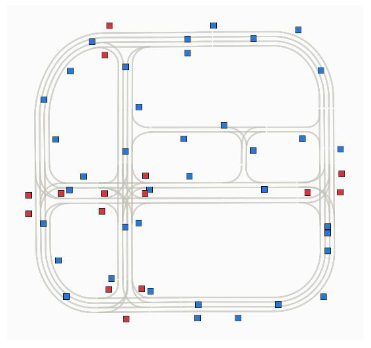
Table 1.
Comparison of Conventional Perception Sensors and UWB-Based Cooperative Localization and Communication.
Table 1.
Comparison of Conventional Perception Sensors and UWB-Based Cooperative Localization and Communication.
| Item | Camera | LiDAR | Radar | UWB |
|---|---|---|---|---|
| Approximate sensor cost |
Low ($30–150) |
Very High ($560–940) |
Medium ($80–140) |
Low ($30–100/node) |
| Representative data rate |
500–3000 Mb/s | 50–100 Mb/s | 5–10 Mb/s | 17 kB/aggregate message |
| Typical processing load |
High | Very High | Medium | Very Low |
| Primary output | Images | 3D point cloud | Range & velocity |
Range and state messages |
Table 2.
Mean Absolute Errors of Localization and Motion States.
| Metric | Mean absolute error | n |
|---|---|---|
| X position (m) | 0.319 | 500 |
| Y position (m) | 0.419 | 500 |
| Yaw (deg) | 1.360 | 500 |
| Speed (m/s) | 0.044 | 500 |
Disclaimer/Publisher’s Note: The statements, opinions and data contained in all publications are solely those of the individual author(s) and contributor(s) and not of MDPI and/or the editor(s). MDPI and/or the editor(s) disclaim responsibility for any injury to people or property resulting from any ideas, methods, instructions or products referred to in the content. |
© 2026 by the authors. Licensee MDPI, Basel, Switzerland. This article is an open access article distributed under the terms and conditions of the Creative Commons Attribution (CC BY) license (http://creativecommons.org/licenses/by/4.0/).
Copyright: This open access article is published under a Creative Commons CC BY 4.0 license, which permit the free download, distribution, and reuse, provided that the author and preprint are cited in any reuse.