

Submitted:
27 September 2026
Posted:
29 September 2026
You are already at the latest version
Abstract
Cultural heritage assets are exposed to diverse environmental, structural, geological, biological, and anthropogenic threats, yet IoT monitoring strategies remain largely site-specific. This study presents and validates the ARGUS framework, a threat-oriented methodology that defines monitoring requirements according to deterioration mechanisms rather than monument typology. The framework integrates heritage characterization, risk assessment, threat-to-sensor mapping, and IoT deployment and was evaluated across five contrasting European heritage sites. Priority threats identified through preliminary risk assessment were compared with evidence obtained from environmental, structural, and operational monitoring. The results showed strong correspondence between the anticipated threats and the deterioration processes observed during monitoring, while also enabling their relative importance to be reassessed. Cross-site comparison revealed recurring relationships between environmental forcing and material or structural responses and showed that heritage assets affected by similar deterioration mechanisms required comparable sensor configurations despite differences in typology, materials, and geographical setting. These recurring configurations were consolidated into transferable monitoring packages addressing moisture, climatic exposure, structural stability, pollution, and operational pressures. The ARGUS framework therefore provides a scalable approach for translating conservation risks into targeted monitoring strategies, supporting risk-informed preventive conservation across heterogeneous cultural heritage contexts.
Keywords:
cultural heritage
; preventive conservation
; Internet of Things (IoT)
; Structural Health Monitoring
; environmental monitoring
; risk-based monitoring
; Wireless Sensor Networks
1. Introduction
Cultural heritage assets constitute an irreplaceable record of human history, identity, and collective memory [1]. However, their long-term preservation is increasingly challenged by a combination of environmental, structural, geological, and anthropogenic pressures [2,3]. Climate change has intensified the frequency and severity of environmental stressors, including extreme temperatures, prolonged droughts, intense rainfall events, flooding, and accelerated weathering processes [1,4,5]. At the same time, many historic structures are affected by ageing materials, ground instability, moisture ingress, pollution, biological colonization, and growing tourism pressures [3,4]. These factors often act simultaneously and cumulatively, accelerating deterioration processes and increasing the vulnerability of heritage assets [1,2,5].
One of the major challenges in heritage conservation is that deterioration is rarely sudden. Instead, damage often develops progressively through a series of interconnected mechanisms that remain invisible until advanced stages are reached [6,7]. Moisture accumulation within masonry may precede salt crystallization and material loss by several years; seasonal thermal cycles may gradually contribute to crack propagation; and environmental fluctuations may lead to structural deformations long before visible damage appears [8,9,10].
As a result, conservation interventions are often undertaken only once signs of deterioration have already appeared, leading to increased expenses, more extensive loss of original materials, and less effective preservation outcomes [6]. Therefore, preventive conservation has become a cornerstone of cultural heritage management, focusing on the early identification and reduction of potential risks to avoid irreversible damage before it occurs [11,12].
The growing availability of digital technologies has created new opportunities for implementing preventive conservation approaches [13,14]. In particular, Wireless Sensor Networks (WSNs), Internet of Things (IoT) technologies, Structural Health Monitoring (SHM) systems, and environmental monitoring platforms have enabled the continuous observation of heritage assets at temporal and spatial scales that were previously unattainable [15,16]. Such technologies allow the acquisition of long-term datasets describing environmental conditions, structural responses, and operational parameters, supporting evidence-based conservation decisions through predictive maintenance and digital-twin integration [16,17,18]. Recent developments in cloud computing, edge computing, and low-power communication protocols have further facilitated the deployment of monitoring systems in remote and complex heritage environments while minimizing intervention in protected structures [15,16,18,19].
Within the cultural heritage domain, IoT technologies offer several advantages. They enable continuous and non-invasive monitoring of assets [12,20,21,22], support long-term observations of slowly evolving deterioration processes [20,23,24], improve the understanding of relationships between environmental forcing and structural response [20,24,25], and provide the basis for early-warning systems capable of identifying abnormal behaviors before visible damage develops [26,27]. Furthermore, the integration of IoT monitoring with digital twins and data-driven decision-support systems is progressively shifting conservation practice from reactive maintenance models toward predictive and risk-informed management strategies [12,17,22,28].
Numerous studies have demonstrated the value of monitoring individual heritage monuments using wireless sensing networks [12,14,20]. Previous research has successfully applied IoT technologies to monitor historical buildings, archaeological sites, museums, monuments, and cultural landscapes [12,29,30]. However, most existing studies are characterized by a strong site-specific focus, addressing individual hazards or evaluating the performance of a limited number of sensors [14,23,31]. As a result, the knowledge generated by these deployments often remains difficult to transfer to other heritage contexts [23,31,32].
A significant gap therefore remains between individual monitoring applications and the development of generalized methodologies that can guide monitoring strategies across different heritage typologies [31,33]. Existing approaches frequently start from the nature of the monument itself, i.e. its architectural or construction typology, rather than from the deterioration mechanisms affecting those assets [33]. Consequently, there is still limited understanding of how monitoring systems can be designed according to identified risks, how sensor selection can be systematically linked to deterioration processes, and how monitoring results can be generalized across heterogeneous cultural heritage contexts [34]. Moreover, few studies have validated monitoring methodologies simultaneously across multiple sites affected by different environmental, structural, and operational threats [3,34].
To address these limitations, this paper presents and validates the ARGUS framework, a threat-oriented IoT monitoring methodology for preventive conservation of cultural heritage [34]. Rather than focusing on the characteristics or typology of a specific heritage asset, the methodology identifies dominant deterioration threats, establishes their associated monitoring requirements, and maps them to appropriate sensing technologies. This approach enables the deployment of scalable and transferable monitoring strategies capable of adapting to diverse heritage environments.
The framework was validated across five European cultural heritage sites representing highly different geographical, environmental, and conservation contexts: the archaeological site of Delos (Greece), the underground wine cellars of Baltanás (Spain), the archaeological and architectural heritage of Monti Lucretili (Italy), the Abbey of Sant’Antonio di Ranverso (Italy), and Schenkenberg Castle (Switzerland). These sites were selected because they encompass a broad range of deterioration mechanisms. By monitoring diverse threats within a common methodological framework, the study provides a unique opportunity to evaluate the transferability of risk-based monitoring strategies across heterogeneous heritage environments.
The objectives of this work are therefore fourfold. First, to develop a risk-based methodology linking deterioration mechanisms with monitoring technologies through a threat-oriented sensor selection process. Second, to validate this methodology across five culturally and geographically diverse heritage sites. Third, to identify common deterioration patterns, transferable monitoring strategies, and effective sensor combinations capable of supporting preventive conservation. Finally, to derive practical recommendations for future heritage monitoring programs, including guidelines for sensor deployment, risk prioritization, stakeholder involvement, and conservation decision-making.
2. Materials and Methods
2.1. ARGUS Threat-Oriented Monitoring Framework
The ARGUS monitoring framework supports preventive conservation through a threat-oriented approach that prioritizes deterioration mechanisms over monument typology, as these mechanisms are often independent of asset type. Thus, heritage assets of different types may require similar monitoring strategies when exposed to comparable threats, while assets within the same category may demand substantially different approaches. Based on this principle, a seven-stage workflow was established consisting of: (i) heritage asset characterization; (ii) threat identification; (iii) risk assessment; (iv) threat-to-sensor mapping; (v) sensor deployment; (vi) data acquisition and interpretation; and (vii) preventive conservation decision-making. Figure 1 illustrates the Transferable ARGUS workflow.
The framework begins with the characterization of the heritage asset and its physical, environmental, and operational context. Based on this assessment, potential deterioration mechanisms are identified and prioritized according to their expected impact and likelihood of occurrence. Appropriate monitoring parameters are subsequently selected and linked to specific sensor technologies. After deploying the sensor network and monitoring the heritage site, the collected data is interpreted in relation to the identified risks to support the definition of preventive conservation measures and early-warning strategies. The resulting workflow provides a transferable methodology that can be adapted to different cultural heritage contexts while maintaining a common conceptual structure. The validation presented in this work focuses on the first five stages, which are described in greater detail in the following subsections.
2.1.1. Assets Characterization: The ARGUS Pilot Sites
Prior to sensor deployment, a structured characterization was carried out for each pilot site, covering its heritage typology, construction materials and age, physical and environmental setting, and available conservation history. This information was compiled through site visits, consultation with heritage managers and conservators, and review of existing conservation reports and, where available, prior structural documentation. The characterization established the baseline context required to interpret the subsequent threat assessment, sensor selection and monitoring results.
The five ARGUS pilot sites were deliberately selected to cover a broad range of cultural heritage contexts and deterioration conditions. They include an extensive archaeological landscape, a subterranean heritage complex, a rural cultural landscape combining natural and built heritage, a medieval monastic complex, and a fortified hilltop ruin. Their geographical distribution across Greece, Spain, Italy and Switzerland also exposes the monitoring framework to markedly different climatic and environmental conditions.
Delos, Greece, represents an extensive archaeological heritage site located on an island in the Aegean Sea. The archaeological complex includes remains of the ancient settlement together with mosaics, frescoes and architectural elements exposed to a combination of marine and climatic influences. The site provides a particularly demanding monitoring context because deterioration is influenced by environmental exposure, including wind, solar radiation, rainfall, salinity and marine pollution, while the archaeological remains are distributed across a large and predominantly open landscape.
Baltanás, Spain, represents a substantially different heritage context: an extensive underground cellar town composed of hundreds of cellars excavated into clay soil. Abandonment and inadequate interventions have contributed to structural deterioration, including partial collapses and landslides. Its underground configuration creates a distinctive microclimatic environment, characterized by very high relative humidity and limited ventilation, while ground movements and water-related processes constitute important structural risks.
Monti Lucretili, Italy, represents a cultural landscape in which natural and built heritage are closely interconnected. The pilot encompasses several areas, including the Villa of Horace, the castle of Montefalco and associated dry-stone wall terraces. The sites are located within a mountainous environment characterized by complex geomorphological conditions, vegetation, erosion processes and difficult accessibility. The pilot is therefore particularly relevant for testing monitoring approaches that operate across different spatial scales and combine environmental, geomorphological and structural information.
Sant'Antonio di Ranverso, Italy, represents a medieval monastic heritage complex in which the conservation of architectural and artistic elements is strongly influenced by environmental conditions. The monitoring context includes the interaction between moisture, temperature, biodeterioration and visitor-related features. These elements affect the condition of the built fabric and decorated surfaces.
Schenkenberg Castle, Switzerland, represents medieval fortified heritage situated in a hilltop environment and exposed to strong seasonal climatic variations. The castle provides a case in which environmental fluctuations, particularly temperature cycling and freeze–thaw processes, interact with structural and material vulnerability.
Taken together, the five pilot sites provide a deliberately heterogeneous test set for evaluating the ARGUS threat-oriented monitoring framework. They differ in heritage typology, scale, materials, accessibility, environmental exposure and dominant deterioration processes. At the same time, they present several recurring conservation challenges, notably moisture-related deterioration, climatic exposure, geomorphological and structural instability, biological processes and anthropogenic pressure. This combination of diversity and recurring deterioration mechanisms provides the basis for evaluating whether a common risk-oriented methodology can be adapted to different heritage contexts and whether comparable monitoring requirements can be identified across sites.
2.1.2. Threat Identification
A preliminary risk assessment was conducted for each pilot site to identify the principal factors contributing to material degradation and structural deterioration. Threat identification was carried out through collaboration between heritage managers, conservators, structural engineers, archaeological experts, and monitoring specialists. Historical records, previous conservation reports, visual inspections, and local environmental conditions were used to define the deterioration mechanisms relevant to each site.
To ensure consistency across all pilot sites, identified threats were grouped into five categories: environmental and climatic, geological and geomorphological, structural, biological, and anthropogenic threats. Environmental threats comprise factors such as moisture, temperature fluctuations, precipitation, solar radiation, wind, air pollution, and other climatic processes that may accelerate material decay. Geological and geomorphological threats include ground instability phenomena, such as erosion, subsidence, landslides, and coastal degradation. Structural threats refer to mechanisms affecting the stability and mechanical behavior of heritage assets, including cracking, displacement, tilting, dynamic movements and soil moisture. Biological threats encompass the activity of organisms capable of degrading heritage materials, including molds, vegetation, insects, and wood-boring organisms. Anthropogenic threats represent human-related factors that may adversely influence conservation conditions, including visitor pressure, vandalism, abandonment, inadequate maintenance, and traffic-induced impacts.
Figure 2 summarizes the threat classification adopted within the ARGUS framework and illustrates how the identified threat categories support risk assessment, early warning, preventive intervention, and long-term conservation planning.
2.1.3. Risk Assessment
Following threat identification, each identified threat was prioritized using the ABC risk assessment methodology previously developed by ICCROM and the Canadian Conservation Institute (CCI) [35], adapted for the ARGUS pilots through the project preparation framework described in Deliverable D6.1 [36] and applied within the ARGUS project [33,37]. The ABC method provides a structured approach for evaluating risks to cultural heritage by considering three components: A, the frequency or time of accumulation of the risk factor; B, the loss of value of the portion of cultural heritage potentially affected; and C, the extent, i.e. the number or proportion of heritage assets that could be affected. Each component is assigned a score from 1 to 5, and the resulting risk magnitude is calculated as (MR = A + B + C), producing a value between 3 and 15.
The use of structured risk-assessment methodologies is increasingly recognized as a key component of preventive conservation, as it enables heritage managers to systematically identify, compare, and prioritize threats before damage becomes irreversible. Beyond serving as a technical evaluation tool, risk assessment functions as a decision-support mechanism for conservation planning, resource allocation, and the definition of monitoring and mitigation strategies under conditions of uncertainty [38].
The application of the ABC methodology provided a standardized framework for comparing threats across the five ARGUS pilot sites and, where appropriate, within specific areas or heritage elements of a site. The assessment was based on the identification of risk scenarios following site inspection and the collection of available contextual and historical information. In particular, the methodology was used to translate qualitative knowledge about the frequency of hazards, the heritage value potentially affected, and the spatial extent of the impact into a structured prioritization of risks.
The assessment also highlighted an important methodological consideration for ARGUS. The ABC method was originally developed primarily for heritage assets such as buildings and collections, whereas several ARGUS pilots involve extensive archaeological and landscape contexts. Consequently, assigning value and estimating spatial extent can be challenging where heritage assets are heterogeneous, dispersed, or characterised by different scales and materials. The risk assessment therefore also explored the application of the method to specific spots and feature classes, while considering GIS-based landscape analysis as a complementary approach to address intra-site variability [38].
Within the ARGUS framework, risk assessment is not an end in itself but rather a mechanism for guiding monitoring design. The prioritization of threats provides a rational basis for determining which processes should be observed, the level of monitoring required, and the allocation of sensing resources across the heritage site. This approach is consistent with the broader ARGUS threat-oriented methodology, where risk identification and prioritization constitute the foundation for subsequent threat-to-sensor mapping and monitoring deployment.
The resulting scores established a hierarchy of threats for each pilot site and provided the basis for defining the monitoring priorities. Rather than being considered as a purely numerical exercise, the ABC assessment was therefore used as a decision-support mechanism to identify the threats for which continuous or periodic monitoring could provide the greatest conservation value. This prioritization directly informed the subsequent definition of monitoring requirements and sensor deployment. The results of the asset identification, threat categorization, and risk assessment for the five ARGUS pilot sites are presented in Section 3.1
2.1.4. Threat to Sensor Mapping
The resulting risk scenarios were subsequently translated into monitoring requirements through a threat–parameter–sensor mapping procedure. The purpose of this step was to establish a direct link between the risks identified through the ABC assessment and the physical variables or observable indicators that could provide evidence of their occurrence, evolution, or potential impact on the heritage asset.
For each priority threat, the monitoring process therefore followed three successive steps. First, the threat identified in the risk assessment was defined in terms of the deterioration or hazard process to be monitored. Second, one or more measurable parameters or indicators were identified that could provide information about that process. Third, the most appropriate sensing technology was selected according to the characteristics of the parameter, the required spatial and temporal resolution, and the conditions under which measurements could be obtained at the site. This provided a common framework for translating risk assessment results into technically implementable monitoring requirements.
The mapping was not intended to establish a one-to-one relationship between a threat and a single sensor. Several threats can require multiple complementary measurements, while the same parameter can contribute to the monitoring of more than one threat. For example, environmental parameters such as temperature and relative humidity can be relevant to several deterioration processes, whereas tiltmeters, crackmeters, GNSS or vibration measurements provide more direct information on structural or ground movements. The sensor planning developed reflects this multimodal approach, combining common environmental sensors with more specialised technologies such as tiltmeters, crackmeters, GNSS, acoustic-emission sensors, accelerometers, fibre-optic Bragg sensors, and multispectral-thermal cameras.
The threat–parameter–sensor mapping consequently provided the basis for defining the minimum monitoring requirements at each pilot site. The final selection also considered practical deployment constraints, including accessibility, network coverage, power supply, and the relevance of the selected location to the monitoring objectives. The detailed threat-to-parameter-to-sensor mappings developed for the ARGUS pilot sites are presented in Section 3.2.
2.1.5. Monitoring Deployment
Sensor deployment translated the threat–parameter–sensor mapping into an operational monitoring network at each pilot site. The objective was not simply to install the largest possible number of sensors, but to establish a monitoring configuration capable of collecting meaningful observations at locations relevant to the identified risks while remaining compatible with the physical and operational constraints of each heritage context.
The initial sensor configurations were therefore treated as adaptive deployment plans rather than fixed hardware lists. The sensors deployed included both commercial devices and custom-developed solutions, while some devices remained subject to technical validation or confirmation of their suitability for final installation [38]. This flexibility allows for adjustments to be made according to actual site conditions and preliminary test results.
The final positioning of the monitoring devices was determined through a combination of risk relevance and practical deployment constraints. In particular, the planning considered accessibility, network coverage, power supply, and the relevance of the monitoring location to the objectives of the project. Consequently, the most appropriate sensor location was not necessarily the location where a threat was expected to be strongest, but rather the location where the relevant phenomenon could be measured reliably without compromising installation and operation.
The resulting monitoring networks combine environmental, structural and, where relevant, anthropogenic measurements, representing the final translation of the risk assessment into field-based monitoring: priority threats determine the parameters to be observed; the parameters determine the sensing technologies; and the physical and operational conditions of each site determine how and where those technologies can ultimately be deployed. The overall sensor networks for the five pilot sites are presented in Section 3.3, while the evaluation of the resulting IoT monitoring performance is presented in Section 3.4.
2.2. Individual and Cross-Site Validation and Transferability
The first five stages of the ARGUS threat-oriented monitoring framework, namely asset characterization, threat identification, risk assessment, threat-to-sensor mapping, and monitoring deployment, provide the basis for designing monitoring strategies tailored to specific heritage sites. However, to demonstrate the robustness and broader applicability of the framework, it is necessary to assess both its effectiveness at individual sites and its capacity to support monitoring decisions across different heritage contexts. Validation was therefore undertaken not only to determine whether the monitoring systems successfully captured the deterioration processes identified during the preliminary assessment, but also to evaluate whether recurring deterioration mechanisms could be addressed through comparable monitoring approaches. This latter aspect is particularly important for assessing the transferability of the framework, as one of its core premises is that monitoring strategies should be driven by deterioration mechanisms rather than by the specific characteristics of individual heritage assets.
The ARGUS framework was therefore evaluated at two complementary levels: (i) individual-site validation and (ii) cross-site analysis and transferability assessment. These levels were applied sequentially to assess whether the preliminary risk assessment was supported by monitoring evidence at each pilot site and whether the deterioration processes identified across the sites showed sufficient recurrence to support the development of transferable monitoring strategies.
Individual-site validation was performed by comparing, for each pilot site, the priority threats identified during the preliminary ABC risk assessment (Section 2.1.3) with the evidence obtained from the monitoring campaign. The analysis examined whether the threats identified during the preliminary assessment were effectively captured by the monitoring system and whether the corresponding measurements provided evidence of the expected deterioration processes. Particular attention was given to determining whether the threats initially classified as priorities were confirmed as significant following the monitoring campaign, as well as whether other threats emerged from the measurements as more critical than initially anticipated. This site-level analysis therefore provided a direct validation of the initial threat assessment and allowed the relative importance of the identified deterioration mechanisms to be reassessed on the basis of measured evidence.
Cross-site analysis and transferability assessment were conducted together to identify recurring deterioration processes and monitoring requirements across the five pilot sites [34]. The monitoring results were compared to identify common deterioration patterns and, where similar processes occurred at two or more sites, to determine whether comparable sensor types or combinations had been used. Recurring deterioration processes and associated monitoring requirements were considered indicative of potential transferability, resulting in the identification of threat-oriented monitoring packages. These packages were not intended as fixed configurations, but as adaptable monitoring strategies that can be applied to different heritage sites presenting comparable deterioration mechanisms.
Overall, the validation procedure followed a progressive logic: the individual-site analysis assessed whether the preliminary risk assessment was confirmed or revised by monitoring evidence, while the combined cross-site and transferability analysis identified recurring deterioration processes and examined whether these could be addressed through comparable monitoring configurations. The results of the individual-site validation and the cross-site analysis and transferability assessment are presented in Section 3.5 and Section 3.6.
3. Results
3.1. Assets, Threats and Risk Assessment of the ARGUS Pilot Sites
Applying the characterization and risk-assessment procedure described in Section 2.1.1, Section 2.1.2 and Section 2.1.3, the principal threats affecting each of the five pilot sites were identified and ranked prior to monitoring deployment. Table 1 summarizes the pilot sites, their heritage characteristics, the identified threats, and the resulting risk-assessment ranking based on [35]. The ranking provides the basis for defining the priority threats that subsequently guided the monitoring strategy.
3.2. Threat-to-Sensor of the ARGUS
Applying the mapping procedure described in Section 2.1.4, each priority threat identified through the risk assessment was translated into one or more measurable parameters and linked to a corresponding sensor type. Table 2 presents representative examples of these threat–parameter–sensor relationships. The resulting mappings provided the basis for selecting the sensor categories deployed at each pilot site, with the final configurations adapted to site-specific conditions and constraints, as described in Section 3.3 (Table 3).
3.3. Monitoring Deployment
The ARGUS framework was implemented across the five pilot sites through the deployment of environmental, structural, and operational monitoring systems. Sensor selection was guided by the threat assessment process described in Section 2, ensuring that each deployment targeted the dominant deterioration mechanisms identified for the site. In total, 80 sensors were installed, covering a broad range of environmental, structural, and operational variables. Table 3 summarizes the deployed monitoring infrastructure at each pilot site.
The deployed sensor networks reflect the diversity of conservation challenges represented by the pilot sites. Environmental monitoring constituted the largest component of the infrastructure, while structural and operational sensors were deployed according to site-specific monitoring requirements.
3.4. IoT Operational Performance
To evaluate the operational performance of the monitoring infrastructure, deployment and communication metrics were compiled across the five pilot sites. In total, 80 sensing systems were deployed to monitor environmental, structural, and operational parameters under substantially different heritage and environmental conditions. Monitoring periods varied according to site-specific deployment schedules. Monitoring began in September 2025 at Ranverso, October 2025 at Delos and Monti Lucretili, December 2025 at Baltanás, and May 2026 at Schenkenberg. Monitoring continued until the end of September 2026, except at Baltanás, where restoration works beginning on 15 April 2026 affected the monitoring deployment.
The monitoring architecture combined LoRaWAN and Wi-Fi communication technologies according to site characteristics, connectivity requirements, and power availability. Cloud services included Worldsensing [40] and Shelly (Shelly Europe Ltd., Sofia, Bulgaria), while MQTT was used for data integration. LoRaWAN supported low-power, long-range communication at geographically distributed and difficult-to-access monitoring locations, whereas Wi-Fi was used where local connectivity and power infrastructure were available.
The monitoring infrastructure operated under markedly different site conditions, including marine exposure, underground environments, mountainous terrain, historic masonry, and exposed ruins. These environments introduced different operational constraints. At Delos, high salinity contributed to corrosion of sensors and protective enclosures. At Baltanás, the underground environment reduced communication coverage and required periodic maintenance of connectivity and power systems. At Monti Lucretili, dense vegetation, difficult accessibility, and occasional vandalism affected sensor access and communication reliability. At Ranverso, administrative and installation requirements constrained deployment locations and extended installation times. At Schenkenberg, the location of monitoring points required specialized access procedures, including climbers, while low temperatures and snow imposed additional installation constraints.
To provide a consistent comparison of LoRaWAN communication performance among the five deployments, gateway records were evaluated over the common observation window from 10 July to 19 August 2026. Hourly gateway availability was calculated as the proportion of expected hourly records for which gateway observations were available. Across the five gateways, aggregate hourly availability was 80.45%. Performance was heterogeneous: two gateways achieved 100% availability, while two others achieved 98.65% and 90.57%, respectively. The remaining gateway showed substantially lower availability (13.06%), accounting for most of the missing gateway-level observations and markedly reducing the aggregate network value.
Radio-link measurements provided additional information on communication performance. Across the available gateway observations, the mean received signal strength indicator (RSSI) was approximately −91.1 dBm, with a median of −89 dBm and an observed range from −126 to −53 dBm. The corresponding mean signal-to-noise ratio (SNR) was approximately 8.3 dB, with a median of 9 dB and an observed range from −19 to 15 dB. These values demonstrate substantial variability among individual links and monitoring locations, consistent with the heterogeneous propagation environments encountered across the pilot sites.
Gateway restart records contained 25 distinct reboot episodes across the five deployments. These events were considered indicators of operational interruptions rather than communication failures because the available records do not establish the cause of each restart. Furthermore, the gateway restart exports retain only a limited number of historical events. Consequently, a formal mean time between failures (MTBF) was not calculated. The mean interval between the recorded reboot episodes was 9.02 days, but this value should be interpreted only as a descriptive metric for the available restart records rather than as a long-term reliability parameter. Similarly, packet-loss rate was not estimated because the gateway dataset contains received-packet counts but does not provide an independent reference for the total number of packets transmitted.

Table 4.
LoRaWAN gateway operational performance and maintenance indicators.
| Metric | Value |
| LoRaWAN gateways evaluated | 5 |
| Common observation window | 10 July–19 August 2026 |
| Mean hourly gateway data availability | 80.45% |
| Gateway availability range | 13.06–100% |
| Gateway reboot episodes recorded | 25 |
| Mean interval between recorded reboot episodes* | 9.02 days |
| Mean RSSI | −91.1 dBm |
| Median RSSI | −89 dBm |
| RSSI range | −126 to −53 dBm |
| Mean SNR | 8.3 dB |
| Median SNR | 9 dB |
| SNR range | −19 to 15 dB |
| Sensor maintenance interventions | 21 |
| Battery replacements | 7 |
| Vandalism incidents | 5 |
| Animal-related incidents | 2 |
| LoRaWAN gateway uptime | 135d 9h 20min (3249.333h) |
*Calculated from the available gateway restart records. The restart exports contain a limited number of historical events and therefore do not provide a complete failure history; this value should not be interpreted as formal MTBF. The gateway availability and radio-link statistics were calculated from the LoRaWAN gateway dataset.
Although interruptions and maintenance requirements occurred during the monitoring campaign, the results indicate that the communication infrastructure provided reliable operation at most deployments, while individual site-specific connectivity limitations could substantially affect aggregate performance. The strong contrast between the four higher-performing gateways and the lowest-performing gateway also demonstrates the importance of evaluating communication performance at deployment level rather than relying exclusively on an overall network average. In complex heritage environments, gateway positioning, topography, physical obstructions, accessibility, and local environmental conditions should therefore be considered integral components of monitoring-system design.
Overall, the operational results demonstrate the feasibility of maintaining an interoperable IoT monitoring infrastructure across heterogeneous cultural heritage environments. The combination of LoRaWAN and Wi-Fi communication, together with cloud-based data management, enabled the acquisition of environmental, structural, and operational observations despite substantial differences in accessibility and environmental exposure among the pilot sites. The observed variability in gateway availability further highlights the need for site-specific communication planning, gateway optimization, and routine maintenance when implementing long-term IoT monitoring for preventive conservation.
3.5. Validation of the Threat-Oriented Framework
To evaluate the ARGUS framework, the dominant threats identified during the preliminary ABC risk assessment were compared with monitoring observations collected during the deployment period. The objective was to determine whether the threat-oriented methodology successfully identified the deterioration processes governing each pilot site. To illustrate the capability of the deployed monitoring systems to capture deterioration processes, representative datasets from each pilot site are presented in Figure 3, Figure 4, Figure 5, Figure 6 and Figure 7. The selected examples correspond to the dominant threats identified during the risk assessment stage and demonstrate the relationship between environmental forcing, material response, and structural behavior.
At the Baltanás pilot site (Figure 4), vertical movements were recorded at the micrometre scale, indicating measurable responses of the cellars to changes in vertical loading or pressure conditions. Accelerometers recorded vibration outliers coinciding with reported collapses, demonstrating their potential for detecting structural events. Soil moisture increased rapidly by approximately 5% over two weeks, suggesting significant changes in subsurface moisture conditions. Relative humidity was consistently high, with a mean above 90% and frequent values approaching 100%, representing potentially critical conditions for material deterioration.
Figure 5 illustrates the influence of anthropogenic pressure at the highly visited site of Monti Lucretili, with up to 30 visitors recorded within a single hour. Although humidity fluctuated considerably, UV radiation remained relatively low during the monitoring period. However, as the data correspond to winter conditions, with UV indices around 3, higher exposure during summer should be considered. Short-duration rainfall events also produced accumulations of approximately 3 mm over consecutive hours. Tiltmeter measurements further recorded displacements of up to 0.2°, highlighting the relevance of structural movement as a potential threat.
At Ranverso Abbey (Figure 6), UV levels inside the abbey remained below 0.025, suggesting extremely low, almost absent, UV exposure to the paintings under the monitored conditions. Relative humidity, however, remained relatively high, with a mean of approximately 70%, which may be relevant for the conservation of painted surfaces. Particulate matter concentrations reached values of approximately 70, likely associated with visitor activity and indicating sustained particle deposition that may, over time, contribute to optical degradation, color shifting, and structural damage to the paint layers. Rapid increases and decreases in soil moisture may also indicate short-term responses to heavy rainfall or localized flooding events.
Finally, Figure 7 presents the monitoring results for Schenkenberg, characterized by substantial daily temperature variations exceeding 10°C, mean wind speeds of approximately 7 m/s, and recorded accelerations predominantly within the 0–10 Hz range. These measurements indicate that thermal and wind-induced environmental fluctuations, together with low-frequency structural vibrations, should be considered among the relevant threats at the site during the summer months.
Across the five pilot sites, monitoring observations consistently confirmed the deterioration mechanisms predicted during the preliminary risk assessment. Moisture-related processes dominated at Baltanás and Ranverso, climate-driven deterioration was predominant at Delos, active structural instability characterized Monti Lucretili, and climate-induced structural stress was the principal concern at Schenkenberg. Table 5 compares the threats identified during the preliminary risk assessment with the evidence obtained during the monitoring campaign. For each site, threats were reassessed according to their observed significance in the monitoring data. A monitoring-based priority ranking was assigned, where 1 represents the threat showing the strongest evidence or greatest apparent significance during the monitoring period, with progressively higher numbers indicating lower observed priority. Threats that could not be adequately evaluated during the monitoring period, either because the relevant conditions did not occur or because sufficient monitoring evidence was unavailable, were left unranked. The monitoring-based ranking is therefore intended as a relative, site-specific prioritization based on the observations collected during the monitoring campaign, rather than as a replacement for the original ABC risk score.
These results provide qualitative validation of the threat-oriented methodology and demonstrate that the preliminary risk assessment successfully guided monitoring design and sensor deployment. The ability to correctly identify the dominant deterioration process across all pilot sites highlights the applicability of the ARGUS framework under diverse environmental and conservation conditions. Ranking threats by observed priority at each site provides the basis for identifying which deterioration mechanisms recur across multiple heritage contexts, examined in Section 3.6.
3.6. Cross-Site Comparability and Transferable Monitoring Packages
Aggregating the priority rankings established in Section 3.5 across the five pilot sites shows that, although the specific dominant threat differs by site, a consistent pattern nevertheless emerges beneath this diversity: environmental conditions were repeatedly associated with measurable material or structural responses, although the strength of this relationship varied among sites. At Delos, strong climatic exposure, including wind gusts and rainfall events, occurred alongside measurable structural inclination. At Baltanás, rainfall preceded rapid increases in soil moisture, while structural movements and vibration outliers were recorded in association with reported cellar collapses. At Monti Lucretili, rainfall and humidity variations occurred alongside sudden crack and inclination movements, with tiltmeter variations reaching approximately 0.2°. At Ranverso, elevated relative humidity and rapid soil-moisture variations demonstrated the response of the site to changing moisture conditions, although a corresponding structural response could not be clearly established. At Schenkenberg, large daily temperature oscillations and moderate-to-high wind exposure occurred alongside measurable low-frequency structural vibrations.
This recurring relationship between environmental forcing and material or structural response, rather than the identity of the threat itself, is transferable across heritage typologies. Across the pilot sites, environmental monitoring provided contextual or leading information for interpreting subsequent changes in material conditions and, where structural measurements were available, structural behavior. This observation supports the central hypothesis explored in this section: that environmental variables can provide early or contextual information for interpreting deterioration risk, independently of monument typology or threat category. It is this relationship, rather than the individual threats themselves, that underpins the transferable monitoring packages presented below.
Analysis of the monitoring deployments carried out across the five pilot sites revealed recurring combinations of sensors associated with specific deterioration mechanisms. These sensor combinations emerged independently of heritage typology, geographical location, and construction characteristics, suggesting that monitoring requirements are primarily determined by conservation threats rather than monument categories. As a result, a series of transferable monitoring packages were identified, each targeting a specific group of deterioration processes. Table 6 shows the five proposed threat packages, the sensors and the representative ARGUS pilot sites for package validation.
The recurrence of these packages across different pilot sites demonstrates that similar deterioration processes generate comparable monitoring requirements, even when heritage assets differ substantially in typology, age, materials, and environmental context. For example, Baltanás and Ranverso represent fundamentally different heritage assets, yet both required nearly identical monitoring configurations due to the predominance of moisture-related deterioration mechanisms. Likewise, Delos and Schenkenberg exhibited comparable requirements for monitoring climate exposure despite their distinct geographical and cultural characteristics. These results provide empirical support for the central hypothesis of the ARGUS framework: heritage assets affected by similar deterioration mechanisms can be monitored using comparable sensor configurations regardless of monument typology. The identified threat packages therefore constitute reusable monitoring solutions that can facilitate future deployments, simplify sensor selection, and improve the transferability of preventive conservation strategies across diverse cultural heritage contexts. This finding represents one of the principal outcomes of the ARGUS validation process and provides the basis for the broader threat-oriented monitoring approach discussed in the following section.
4. Discussion
4.1. From Monument-Based to Threat-Based Monitoring
The comparison of the five ARGUS pilot sites revealed a consistent and significant finding: monitoring requirements were more strongly associated with deterioration mechanisms than with monument typology. Although the pilot sites differed substantially in age, construction materials, architectural characteristics, environmental conditions, and conservation status, sites affected by similar deterioration processes required comparable monitoring strategies.
Traditional cultural heritage monitoring programs are commonly organized according to asset typologies. However, the results obtained during the ARGUS validation demonstrate that deterioration mechanisms constitute a more reliable basis for monitoring design than monument classification. Sites affected by comparable degradation processes consistently required similar monitoring configurations despite substantial differences in function, historical context, and geographical location.
For example, Baltanás and Ranverso represent fundamentally different heritage assets, yet both exhibited moisture-related deterioration processes associated with groundwater influence, capillary rise, and high relative humidity. Consequently, both sites required similar monitoring systems based on temperature, relative humidity, moisture content, airflow, and hydrological measurements. Likewise, Delos and Schenkenberg, despite their geographical and cultural differences, shared monitoring requirements related to climatic exposure, weathering, and environmental forcing.
These observations support the central hypothesis of the ARGUS framework: monitoring strategies should be defined according to deterioration mechanisms rather than monument typology. The successful validation of this approach across five contrasting pilot sites demonstrates its applicability to a wide range of cultural heritage environments.
Furthermore, the transferability of the framework extends beyond the methodological level. By integrating commercial monitoring systems and custom-developed low-cost sensor nodes through a common MQTT-based architecture, ARGUS demonstrates that threat-oriented monitoring can remain independent of specific hardware implementations and communication technologies. This interoperability facilitates the deployment of reusable monitoring solutions across diverse heritage contexts.
This shift from monument-based to threat-based monitoring represents the principal scientific contribution of the ARGUS framework and provides a practical foundation for risk-informed heritage monitoring and preventive conservation.
4.2. Transferable Monitoring Packages
One of the most relevant outcomes of the cross-site comparison was the identification of recurring sensor combinations associated with specific deterioration mechanisms. These recurring configurations emerged independently of heritage typology and therefore provide the basis for transferable monitoring packages applicable to a wide range of conservation scenarios.
The Moisture Monitoring Package combines temperature sensors, relative humidity sensors, soil and wall moisture sensors, airflow measurements, and water-level observations. This package proved particularly effective at Baltanás and Ranverso, where moisture accumulation, capillary rise, flooding risk, and groundwater dynamics represented the dominant deterioration mechanisms. The integration of these variables allows moisture sources to be identified and drying conditions to be evaluated more accurately than with isolated measurements.
The Structural Stability Package integrates tiltmeters, crackmeters, GNSS systems, and vibration sensors. This configuration was especially valuable at Monti Lucretili and Schenkenberg, where structural behaviour constituted a major conservation concern. The combination of geometric, displacement, and vibration measurements provides complementary information for distinguishing environmentally related responses from potentially progressive structural changes.
The Climate Exposure Package combines weather stations with measurements of rainfall, temperature, wind, solar radiation, UV exposure, and illuminance. Deployments at Delos and Schenkenberg demonstrated the effectiveness of this package for characterizing environmental forcing and evaluating conservation risks associated with weathering, thermal stress, and freeze-thaw processes.
Perhaps the most important observation is that reliable diagnosis rarely resulted from individual sensors considered in isolation. Instead, deterioration mechanisms became significantly easier to interpret when environmental variables and structural responses were analyzed together. Interpretation of crack development was improved when evaluated alongside changes in moisture, rainfall, temperature, and wind conditions. Similarly, the interpretation of tilt measurements improved considerably when climatic and hydrological information was incorporated.
These findings indicate that future heritage monitoring systems should prioritize integrated sensing networks capable of simultaneously capturing deterioration drivers and the responses they generate.
4.3. Implications for Preventive Conservation
The results obtained from the ARGUS monitoring campaign have important implications for preventive conservation. Traditional conservation strategies often remain reactive, focusing on the treatment of visible damage after deterioration has already occurred. While corrective interventions are sometimes unavoidable, they generally involve higher costs, greater material loss, and more invasive actions than preventive approaches.
The threat-oriented methodology demonstrated by ARGUS provides a mechanism for identifying deterioration drivers before significant damage develops, allowing interventions to be implemented at an earlier stage.
Moisture-related processes emerged as one of the most recurrent deterioration mechanisms across the pilot sites, particularly at Baltanás and Ranverso, while also contributing to climate-driven deterioration processes at other sites. Consequently, interventions aimed at improving drainage, reducing water infiltration, enhancing ventilation, controlling groundwater influence, and limiting humidity accumulation are likely to provide the greatest conservation benefits.
A second priority concerns structural instability. Sites exhibiting progressive crack development, displacement trends, or persistent geometric changes require detailed structural assessment and stabilization before deterioration reaches critical levels. The observations obtained at Monti Lucretili illustrate the importance of monitoring structural responses alongside environmental forcing.
A third priority relates to environmental and climatic exposure. Highly exposed sites such as Delos and Schenkenberg are particularly vulnerable to weathering processes associated with solar radiation, wind, extreme temperatures, and freeze-thaw cycles. Protective measures, improved drainage, vegetation management, and climate adaptation strategies may therefore contribute significantly to reducing long-term deterioration rates.
Beyond individual sites, the ARGUS framework also provides a practical mechanism for translating climate-related risks into measurable monitoring variables. The integration of environmental, structural, and operational datasets enables the development of evidence-based conservation strategies that support adaptation to changing environmental conditions.
Overall, the results demonstrate that preventive conservation can be strengthened by prioritizing deterioration drivers rather than deterioration symptoms. By linking risk assessment, monitoring, and conservation decision-making within a common framework, ARGUS provides a transferable methodology for supporting long-term, evidence-based management of cultural heritage assets.
4.4. Limitations and Future Work
Several limitations of the present study should be acknowledged. First, monitoring periods varied among the pilot sites and, in some cases, were limited to less than one annual climatic cycle. Consequently, the long-term evolution of certain deterioration mechanisms, particularly those influenced by seasonal variability or low-frequency events, could not be comprehensively assessed. Second, while the framework was validated across a diverse set of environmental and heritage contexts, some deterioration processes, such as biological colonization and material-specific decay mechanisms, were not systematically monitored or validated at all sites. Third, the validation focused primarily on the ability of the framework to identify and monitor dominant deterioration mechanisms rather than on quantifying deterioration rates or predicting future damage. As a result, the monitoring thresholds used for alerts and preventive interventions should be considered preliminary and require further calibration through longer-term observations and larger datasets.
In addition, the current validation involved five European pilot sites representing a limited range of climatic, geological, and management conditions. Further testing in other geographical regions and heritage contexts would be necessary to evaluate the broader transferability of the framework. Future research should also explore the integration of predictive analytics, deterioration forecasting models, and data-driven decision-support tools capable of transforming monitoring observations into quantitative risk predictions and conservation recommendations. Finally, the long-term assessment of framework performance would benefit from direct evaluation of how monitoring-informed interventions influence conservation outcomes, maintenance costs, and asset resilience over time.
5. Conclusions
This study validated the ARGUS framework across five European cultural heritage pilot sites, demonstrating the feasibility of a transferable threat-oriented monitoring approach that integrates risk assessment, IoT-based sensing technologies, and preventive conservation principles. Unlike conventional monitoring strategies organized according to monument typology, the proposed framework was designed around deterioration mechanisms, enabling monitoring requirements to be defined according to conservation risks rather than asset categories.
The results showed a high degree of correspondence between the threats identified during the preliminary ABC risk assessment and the deterioration processes observed through monitoring. Across all pilot sites, the dominant deterioration mechanisms predicted during the assessment stage were confirmed by sensor observations, demonstrating the effectiveness of the threat-oriented methodology for guiding sensor selection and deployment. Environmental variables provided important contextual and, in some cases, leading information for interpreting material and structural responses, while moisture-related processes emerged as a recurrent conservation risk across multiple sites.
The comparative analysis further revealed that monuments exposed to similar deterioration mechanisms required comparable monitoring configurations despite substantial differences in architecture, materials, geographical setting, and historical function. This finding led to the identification of a set of transferable monitoring packages associated with recurring threats, including moisture-related deterioration, climate exposure, and structural instability. These packages provide practical and reusable monitoring solutions that can support future heritage monitoring deployments.
The principal contribution of the ARGUS framework is the demonstration that heritage monitoring can be organized and standardized around deterioration processes rather than monument categories. By linking threat assessment, sensor selection, monitoring deployment, and preventive conservation within a common methodology, the framework provides a scalable foundation for risk-informed conservation management, predictive maintenance, and climate-resilient heritage preservation.
Overall, the results support a transition from monument-based monitoring strategies to threat-oriented approaches that focus on the drivers of deterioration. This shift has the potential to improve the efficiency, transferability, and long-term sustainability of monitoring programs, while strengthening the role of digital technologies in preventive conservation and evidence-based heritage management.
Author Contributions
Conceptualization, F.R., L.A., A.L., J.J.A., and S.A.; methodology, F.R., L.A., A.L., J.J.A., and S.A.; software, F.R., L.A., and S.A.; validation, F.R., L.A., A.L., J.J.A., I.G.M., D.S. and S.A.; formal analysis, F.R., L.A., A.L., J.J.A., I.G.M., D.S. and S.A.; investigation, F.R., L.A., A.L., J.J.A., I.G.M., D.S. and S.A.; resources, S.A..; data curation, F.R. and L.A.; writing—original draft preparation, F.R., L.A., A.L., J.J.A., and S.A.; writing—review and editing, F.R., L.A., A.L., J.J.A., I.G.M., D.S. and S.A.; visualization, F.R., L.A.; supervision, J.J.A.; project administration, S.A.; funding acquisition, S.A. All authors have read and agreed to the published version of the manuscript.
Funding
This work has been supported by the ARGUS EU project (Grant Agreement No. 101132308), funded by the European Union. The views and opinions expressed are, however, those of the author(s) only and do not necessarily reflect those of the European Union or of the European Research Executive Agency (REA). Neither the European Union nor the granting authority can be held responsible for them.
Data Availability Statement
The datasets presented in this article are not readily available because the data are part of an ongoing study. Requests to access the datasets should be directed to the corresponding authors.
Acknowledgments
The authors would like to dedicate this section to Dr. Anaya on the occasion of his retirement. We express our deepest gratitude for his outstanding mentorship, and the profound impact he has made on our academic community. During the preparation of this publication, the authors used Microsoft Copilot (M365 Copilot, GPT-5) and ChatGPT (v 5.5) to assist with language refinement, English language phrasing and reduction of text length. Figures 1 and 2 were illustrated with AI. The authors have reviewed and edited the output and take full responsibility for the content of this publication.
Conflicts of Interest
The authors declare no conflicts of interest. Angela Lluch and Ignasi Garcia-Milà are employees of Worldsensing S.L. and contributed to sensor deployment and investigation activities in this study. Worldsensing S.L. did not provide funding for this research and had no role in the study design; data analysis or interpretation; manuscript preparation; or the decision to publish the results.
Appendix A. Supplementary Monitoring Datasets
Table A1.
Sensor deployment matrix.
| Threat Category | Deterioration Mechanism / Threat | Monitoring Parameter | Sensor Type |
| Moisture-related | High relative humidity | Relative humidity | RH sensor |
| Moisture accumulation | Soil moisture | Soil moisture probe | |
| Capillary rise | Soil moisture, wall moisture, conductivity | Soil moisture probe, conductivity sensor | |
| Condensation risk | Temperature, RH | Temperature and RH sensors | |
| Poor ventilation | Airflow | Airflow meter | |
| Flooding | Water level | Water level sensor | |
| Groundwater influence | Soil moisture, tensiometric pressure | Soil moisture probe, tensiometer | |
| Climate-driven | Solar radiation exposure | Solar radiation | Pyranometer / solar radiation sensor |
| UV weathering | UV intensity | UV sensor | |
| Excessive illumination | Light intensity | Lux meter | |
| Thermal stress | Air temperature | Temperature sensor | |
| Freeze–thaw cycles | Air and soil temperature, moisture | Temperature and soil moisture sensors | |
| Wind erosion | Wind speed and direction | Anemometer | |
| Rainfall impact | Rainfall | Rain gauge | |
| Atmospheric pressure variations | Barometric pressure | Pressure sensor | |
| Geological / Geomorphological | Subsidence | Horizontal and vertical displacement | GNSS |
| Landslides | Displacement, tilting, soil moisture | GNSS, tiltmeter, soil moisture sensor | |
| Ground settlement | Displacement | GNSS | |
| Hydrogeological instability | Moisture, rainfall, displacement | Moisture sensors, rain gauge, GNSS | |
| Soil erosion | Rainfall, soil moisture, displacement | Rain gauge, soil moisture sensor, GNSS | |
| Structural | Tilting | Rotation | Tiltmeter |
| Structural deformation | Inclination, displacement | Tiltmeter, GNSS | |
| Crack propagation | Crack opening | Crackmeter | |
| Dynamic loading | Vibrations | Vibration meter | |
| Structural instability | Crack evolution, tilt, displacement | Crackmeter, tiltmeter, GNSS | |
| Seismic response | Vibrations | Vibration meter | |
| Atmospheric | Air pollution | Gas concentration | Gas detector |
| Traffic emissions | NO₂, CO, SO₂ | Gas detector | |
| Marine pollution | Air quality indicators | Gas detector | |
| Particulate deposition | PM1, PM2.5, PM10 | Particle detector | |
| Biological | Biodeterioration | RH, temperature, moisture | RH, temperature and moisture sensors |
| Mould growth | Temperature, RH | Temperature and RH sensors | |
| Biological colonisation | Moisture conditions | Moisture sensors | |
| Vegetation growth | Soil moisture, climate variables | Soil moisture and weather sensors | |
| Anthropogenic | Visitor pressure | Occupancy | People counter |
| Human-induced microclimate changes | Occupancy, CO₂, RH, temperature | People counter, gas sensor, climate sensors | |
| Human-induced vibrations | Vibrations | Vibration meter | |
| Vandalism / unauthorized access | Presence detection | People counter / PIR sensor |
To maintain the readability of the manuscript and focus the discussion on deterioration mechanisms and conservation implications, the complete multi-sensor datasets acquired at each pilot site are provided as Supplementary Material. These figures contain the full set of environmental, structural, and operational measurements collected during the monitoring campaign and serve as the basis for the analyses presented in the Results and Discussion sections.
The supplementary figures allow interested readers to examine the behavior of individual sensors and assess the temporal evolution of all monitored parameters. While the main manuscript focuses on representative trends and cross-site comparisons, the complete datasets are provided to ensure transparency, reproducibility, and detailed interpretation of the monitoring results.
Figure S1.
Complete Baltanás Dataset. Comprehensive visualization of all environmental, structural, and operational parameters monitored at the Baltanás Wine Cellars pilot site, including temperature, relative humidity, airflow, soil and wall moisture, gas concentrations, vibrations, GNSS displacements, and visitor-related measurements.
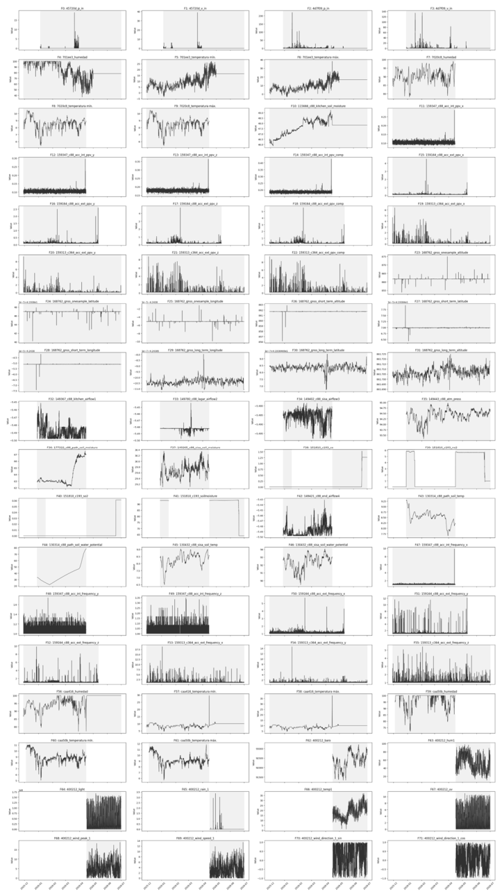
Figure S2.
Complete Delos Dataset. Complete monitoring dataset for the Delos archaeological site, including weather station variables, temperature, relative humidity, UV radiation, solar radiation, wind conditions, soil moisture, tiltmeter measurements, and visitor counts.
Figure S2.
Complete Delos Dataset. Complete monitoring dataset for the Delos archaeological site, including weather station variables, temperature, relative humidity, UV radiation, solar radiation, wind conditions, soil moisture, tiltmeter measurements, and visitor counts.
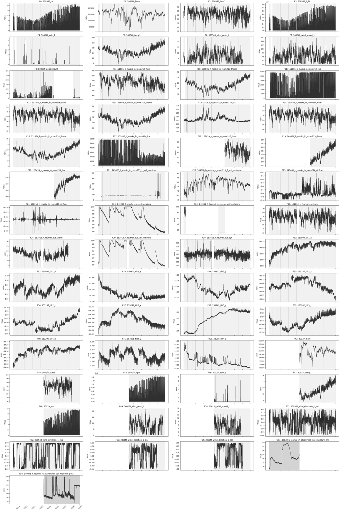
Figure S3.
Complete Monti Lucretili Dataset. Full sensor dataset acquired at the Monti Lucretili pilot site, including environmental parameters, weather station measurements, crackmeter data, tiltmeter records, vibrations, GNSS observations, and operational monitoring variables.
Figure S3.
Complete Monti Lucretili Dataset. Full sensor dataset acquired at the Monti Lucretili pilot site, including environmental parameters, weather station measurements, crackmeter data, tiltmeter records, vibrations, GNSS observations, and operational monitoring variables.
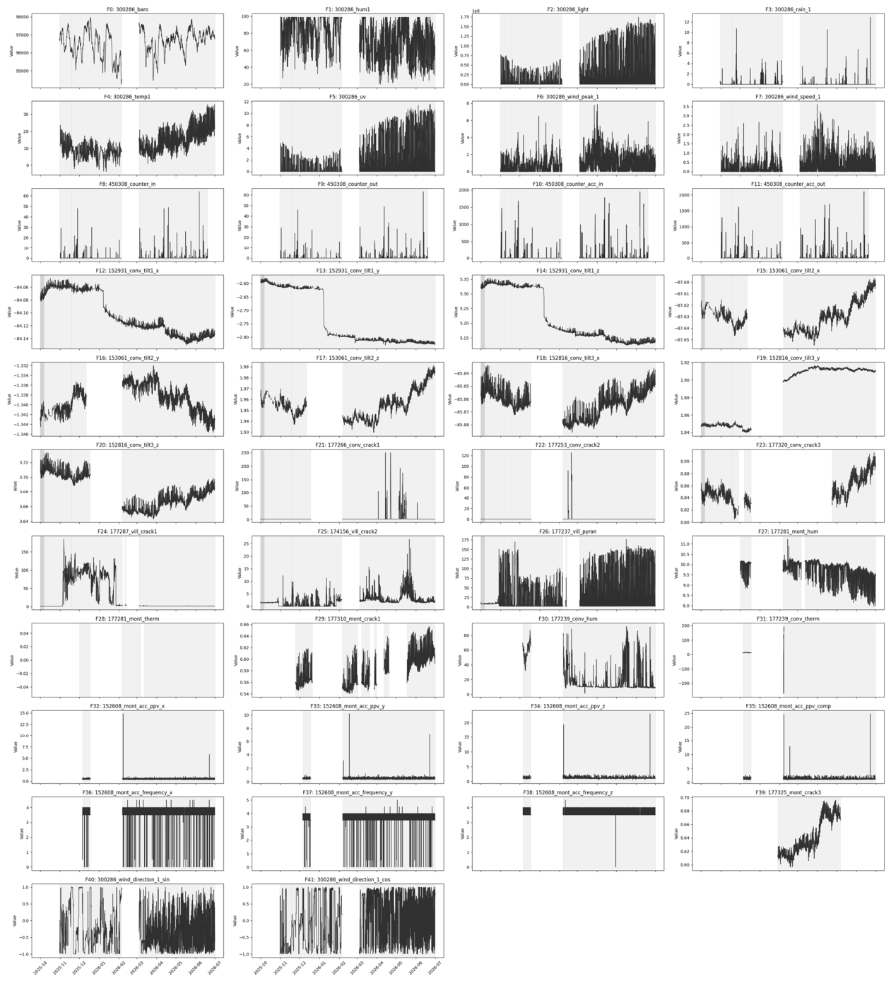
Figure S4.
Complete Ranverso Dataset. Comprehensive monitoring dataset for the Abbey of Sant'Antonio di Ranverso, including indoor temperature and humidity, wall moisture measurements, airflow observations, gas and particulate monitoring, tiltmeter data, and vibration measurements.
Figure S4.
Complete Ranverso Dataset. Comprehensive monitoring dataset for the Abbey of Sant'Antonio di Ranverso, including indoor temperature and humidity, wall moisture measurements, airflow observations, gas and particulate monitoring, tiltmeter data, and vibration measurements.
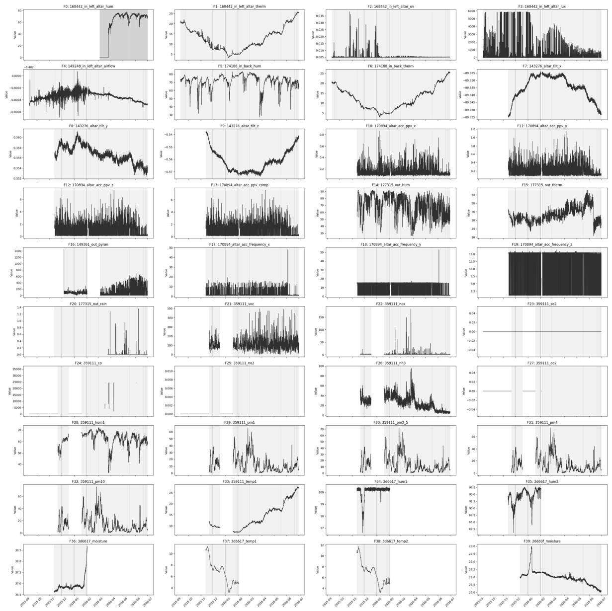
Figure S5.
Complete Schenkenberg Dataset. Complete dataset for Schenkenberg Castle, including weather conditions, humidity, rainfall, UV exposure, wind measurements, crackmeter and tiltmeter records, vibration monitoring, and structural frequency measurements.
Figure S5.
Complete Schenkenberg Dataset. Complete dataset for Schenkenberg Castle, including weather conditions, humidity, rainfall, UV exposure, wind measurements, crackmeter and tiltmeter records, vibration monitoring, and structural frequency measurements.
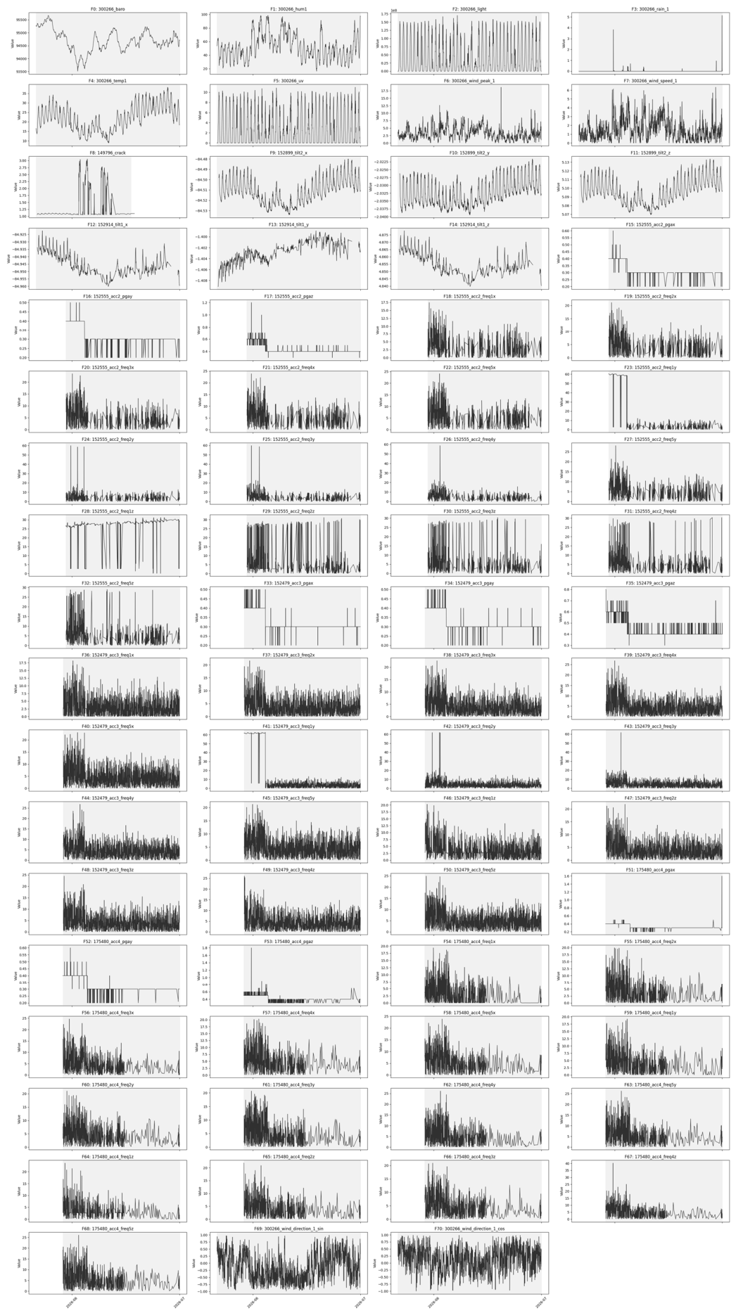
The complete sensor datasets presented in Figure S1–S5 are intended to complement the results reported in the main manuscript. The analysis presented in the Results section focuses on deterioration mechanisms and risk indicators rather than individual sensor behavior. Accordingly, only representative variables and comparative trends are discussed in the paper, while the complete monitoring records are made available in the Supplementary Material for detailed inspection and future reuse.
References
- Sesana, E.; Gagnon, A.S.; Ciantelli, C.; Cassar, J.A.; Hughes, J.J. Climate change impacts on cultural heritage: A literature review. WIREs Clim. Chang. 2021, 12, e710. [Google Scholar] [CrossRef]
- Bonazza, A.; Sardella, A. Climate Change and Cultural Heritage: Methods and Approaches for Damage and Risk Assessment Addressed to a Practical Application. Heritage 2023, 6, 3578–3589. [Google Scholar] [CrossRef]
- Bertolin, C. Preservation of Cultural Heritage and Resources Threatened by Climate Change. Geosciences 2019, 9, 250. [Google Scholar] [CrossRef]
- Esteban-Cantillo, O.J.; Menendez, B.; Quesada, B. Climate change and air pollution impacts on cultural heritage building materials in Europe and Mexico. Sci. Total Environ. 2024, 170945. [Google Scholar] [CrossRef]
- Blavier, C.L.; Huerto-Cardenas, H.E.; Aste, N.; Del Pero, C.; Leonforte, F.; Della Torre, S. Adaptive measures for preserving heritage buildings in the face of climate change: A review. Build. Environ. 2023, 245, 110832. [Google Scholar] [CrossRef]
- Makoond, N.; Pelà, L.; Molins, C.; Roca, P.; Alarcón, D. Automated data analysis for static structural health monitoring of masonry heritage structures. Struct. Control Health Monit. 2020, 27, e2581. [Google Scholar] [CrossRef]
- Lignola, G.P.; Buratti, N.; Cattari, S.; Parisi, F.; Ubertini, F.; Alfano, S.; Ierimonti, L.; Meoni, A.; Sivori, D.; Virgulto, G. Validated and Optimized Strategies for Preserving Historical Heritage Towards Natural and Anthropic Risks: Insights from the DETECT-AGING Project. Buildings 2025, 15, 693. [Google Scholar] [CrossRef]
- Hernández, I.E.; Collazo, A.A.; López, E.C. Crystallization Cycles in Masonry Walls: Experimental Technique to Develop Accelerated Aging on a Real Scale. Period. Polytech. Archit. 2024, 55, 1–11. [Google Scholar] [CrossRef]
- Abdullah, G.M.; El-Aal, A.A.; Radwan, A.E.; Al-Awah, H. Numerical simulation and diagnosis geotechnical parameters of historical buildings in Najran City, Kingdom of Saudi Arabia. Sci. Rep. 2023, 13, 16968. [Google Scholar] [CrossRef]
- Derluyn, H.; Vontobel, P.; Mannes, D.; Derome, D.; Lehmann, E.; Carmeliet, J. Saline Water Evaporation and Crystallization-Induced Deformations in Building Stone: Insights from High-Resolution Neutron Radiography. Transp. Porous Med. 2019, 128, 895–913. [Google Scholar] [CrossRef]
- Waller, R. Evolution of Preventive Conservation from a Risk Analysis Perspective. J. Am. Inst. Conserv. 2026, 65, 50–58. [Google Scholar] [CrossRef]
- Laohaviraphap, N.; Waroonkun, T. Integrating Artificial Intelligence and the Internet of Things in Cultural Heritage Preservation: A Systematic Review of Risk Management and Environmental Monitoring Strategies. Buildings 2024, 14, 3979. [Google Scholar] [CrossRef]
- Machete, R.; Dias, F.M.; Caetano, D.M.; Falcão, A.P.; Gomes, M.d.G.; Bento, R. A Solution for Heritage Monitoring Based on Wireless Low-Cost Sensors and BIM: Application to the Monserrate Palace. Sensors 2026, 26. [Google Scholar] [CrossRef]
- Barsocchi, P.; Bartoli, G.; Betti, M.; Girardi, M.; Mammolito, S.; Pellegrini, D.; Zini, G. Wireless Sensor Networks for Continuous Structural Health Monitoring of Historic Masonry Towers. Int. J. Archit. Herit. 2021, 15, 22–44. [Google Scholar] [CrossRef]
- https://doi.org/10.1080/15583058.2020. 1719.
- Michalakis, K.; Moraitou, E.; Aliprantis, J.; Caridakis, G. Semantic representation and Internet of Things in cultural heritage preventive conservation. In Proceedings of the International Conference on Cultural Informatics, Communication & Media Studies, 2020; Volume 1. [Google Scholar] [CrossRef]
- Colace, F.; Limongiello, M.; Lorusso, A.; Pellegrino, M.; Santaniello, D.; Santoriello, A. Digital twin for cultural heritage: A computational approach to predictive conservation. Digit. Appl. Archaeol. Cult. Herit. 2026, e00519. [Google Scholar] [CrossRef]
- Mardanshahi, A.; Sreekumar, A.; Yang, X.; Barman, S.K.; Chronopoulos, D. Sensing Techniques for Structural Health Monitoring: A State-of-the-Art Review on Performance Criteria and New-Generation Technologies. Sensors 2025, 25, 1424. [Google Scholar] [CrossRef]
- Ni, Z. Data-Driven Smart Maintenance of Historic Buildings . Ph.D. Thesis, Linköping University, Linköping, Sweden, 2025. [Google Scholar] [CrossRef]
- Dolińska, N.; Wojciechowska, G.; Bednarz, Ł. Monitoring Environmental and Structural Parameters in Historical Masonry Buildings Using IoT LoRaWAN-Based Wireless Sensors. Buildings 2025, 15, 282. [Google Scholar] [CrossRef]
- Bacco, M.; Barsocchi, P.; Cassará, P.; Germanese, D.; Gotta, A.; Leone, G.R.; Moroni, D.; Pascali, M.A.; Tampucci, M. Monitoring ancient buildings: Real deployment of an IoT system enhanced by UAVs and virtual reality. IEEE Access 2020, 8, 50131–50148. [Google Scholar] [CrossRef]
- Mazzetto, S. Integrating Emerging Technologies with Digital Twins for Heritage Building Conservation: An Interdisciplinary Approach with Expert Insights and Bibliometric Analysis. Heritage 2024, 7, 6432–6479. [Google Scholar] [CrossRef]
- Mitro, N.; Krommyda, M.; Amditis, A. Smart Tags: IoT Sensors for Monitoring the Micro-Climate of Cultural Heritage Monuments. Appl. Sci. 2022, 12, 2315. [Google Scholar] [CrossRef]
- Ubertini, F.; Comanducci, G.; Cavalagli, N.; Pisello, A.L.; Materazzi, A.L.; Cotana, F. Environmental effects on natural frequencies of the San Pietro bell tower in Perugia, Italy, and their removal for structural performance assessment. Mech. Syst. Signal Process. 2017, 82, 307–322. [Google Scholar] [CrossRef]
- Cavalagli, N.; Kita, A.; Castaldo, V.L.; Pisello, A.L.; Ubertini, F. Hierarchical environmental risk mapping of material degradation in historic masonry buildings: An integrated approach considering climate change and structural damage. Constr. Build. Mater. 2019, 215, 998–1014. [Google Scholar] [CrossRef]
- Wang, J.; Chen, H.; Du, X. Study on the early warning mechanism for real-time monitored structural responses of a historical timber building. Measurement 2020, 165, 108136. [Google Scholar] [CrossRef]
- Wu, Y.; Dong, Y.; Shan, Z.; Meng, X.; He, Y.; Jia, P.; Lu, D. Enhancing Anomaly Detection for Cultural Heritage via Long Short-Term Memory with Attention Mechanism. Electronics 2024, 13, 1254. [Google Scholar] [CrossRef]
- Vuoto, A.; Funari, M.F.; Lourenço, P.B. Shaping digital twin concept for built cultural heritage conservation: A systematic literature review. Int. J. Archit. Herit. 2024, 18, 1762–1795. [Google Scholar] [CrossRef]
- Casillo, M.; Colace, F.; Lorusso, A.; Marongiu, F.; Santaniello, D. An IoT-based system for expert user supporting to monitor, manage and protect cultural heritage buildings. In Robotics and AI for Cybersecurity and Critical Infrastructure in Smart Cities; Nedjah, N., El-Latif, Abd, Gupta, A.A., Mourelle, B.B.L.M., Eds.; Springer: Cham, Switzerland, 2022; Volume 1030, pp. 143–154. [Google Scholar] [CrossRef]
- Bucciero, A.; Chirivì, A.; Colella, R.; Emara, M.; Greco, M.; Jaziri, M.A.; Muci, I.; Pandurino, A.; Taurino, F.V.; Zecca, D. IoT-Based Platform for Wireless Microclimate Monitoring in Cultural Heritage. Heritage 2026, 9, 57. [Google Scholar] [CrossRef]
- Rossi, M.; Bournas, D. Structural Health Monitoring and Management of Cultural Heritage Structures: A State-of-the-Art Review. Appl. Sci. 2023, 13, 6450. [Google Scholar] [CrossRef]
- Krommyda, M.; Mitro, N.; Amditis, A. Smart IoT sensor network for monitoring of cultural heritage monuments. In Smart Trends in Computing and Communications; Zhang, Y.D., Senjyu, T., So-In, C., Joshi, A., Eds.; Springer: Singapore, 2022; Volume 286, pp. 175–184. [Google Scholar] [CrossRef]
- Ioannidis, C.; Verykokou, S.; Soile, S.; Istrati, D.; Spyrakos, C.; Sarris, A.; Akritidis, D.; Feidas, H.; Georgoulias, A.K.; Tringa, E.; et al. Safeguarding Our Heritage—The TRIQUETRA Project Approach. Heritage 2024, 7, 758–793. [Google Scholar] [CrossRef]
- Pavlidis, G.; Sevetlidis, V.; Arampatzakis, V.; Aparicio, S.; Ramonet, F.; Blazquez, L.P.; Janer, M.; Ahorsu, R.; Lluch, A.; Mila, I.G. Sensor-driven preventive preservation in remote built heritage: A threat-to-sensor approach. In Proceedings of the 2025 IEEE International Conference on Cyber Humanities (IEEE-CH), 8 September 2025; pp. 1–6. [Google Scholar] [CrossRef]
- Abad, L.; Ramonet, F.; Ortega, J.; Anaya, J.J.; Aparicio, S. Nested Spatiotemporal Anomaly Detection with Semantic Augmentation: A Case Study in Heritage Conservation. Sensors 2026, 26, 5931. [Google Scholar] [CrossRef]
- Ashley-Smith, J. Cultural property risk analysis model. Development and application to preventive conservation at the Canadian Museum of Nature. Stud. Conserv. 2004, 49, 283–284. [Google Scholar] [CrossRef]
- Farinetti, E.; et al. Deliverable D6.1 (Final): Pilots' Preparation Report . Unpublished project deliverable, ARGUS Project, Grant Agreement No. 101132308, 2025. [Google Scholar]
- Pavlidis, G.; Arampatzakis, V.; Sevetlidis, V.; Koutsoudis, A.; Arnaoutoglou, F.; Ioannakis, G.A.; Kiourt, C. Towards Evolving Actor–Network Ontologies: Enabling Reflexive Digital Twins for Cultural Heritage. Information 2025, 16, 892. [Google Scholar] [CrossRef]
- Michaelides, K.; Agapiou, A. A Review of Multi-Criteria Decision Analysis (MCDA) for Cultural Heritage Risk Assessment Using Geospatial and Earth Observation Data. Geomatics 2026, 6, 88. [Google Scholar] [CrossRef]
- Aparicio, S.; Ramonet, F.; Abad, L.; Sánchez, D.; Cruz, A.; Yin, T.; Zhang, R.; Anaya, J.J. Sensor System Design and Deployment for Environmental and Visitor Monitoring in Cultural Heritage Sites. Sensors 2026, 26, 4941. [Google Scholar] [CrossRef]
- Worldsensing. CMT Cloud. 2026. Available online: https://www.worldsensing.com/product/cmt-cloud/ (accessed on 25 September 2026).
Figure 1.
Transferable ARGUS workflow.
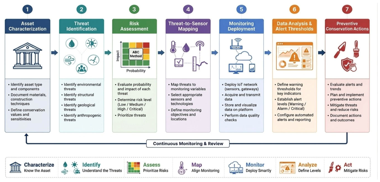
Figure 2.
Threat classification adopted within the ARGUS framework and its role in supporting risk assessment, early warning, preventive intervention, and long-term conservation planning.
Figure 2.
Threat classification adopted within the ARGUS framework and its role in supporting risk assessment, early warning, preventive intervention, and long-term conservation planning.
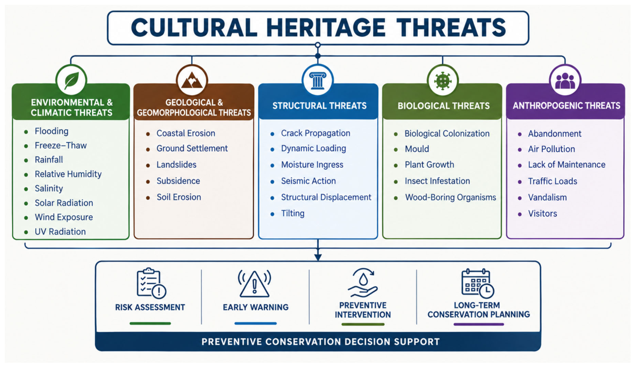
Figure 3.
Example of monitored data in Delos: rainfall, relative humidity, wind peaks, and structural movement (tilt angle).
Figure 3.
Example of monitored data in Delos: rainfall, relative humidity, wind peaks, and structural movement (tilt angle).
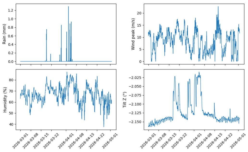
Figure 4.
Example of monitored data in Baltanás: ground displacement (GNSS altitude), vibrations (PPV), soil moisture, and relative humidity.
Figure 4.
Example of monitored data in Baltanás: ground displacement (GNSS altitude), vibrations (PPV), soil moisture, and relative humidity.
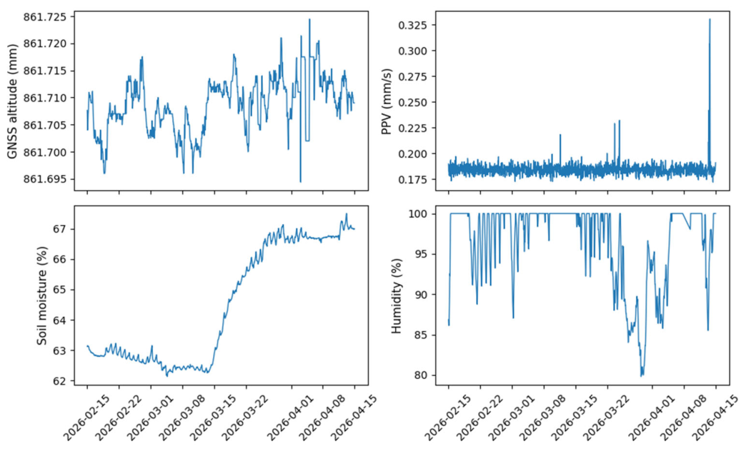
Figure 5.
Example of monitored data in Monti Lucretili: visitor counts, rainfall, relative humidity, UV index, and structural movement (tilt angle).
Figure 5.
Example of monitored data in Monti Lucretili: visitor counts, rainfall, relative humidity, UV index, and structural movement (tilt angle).
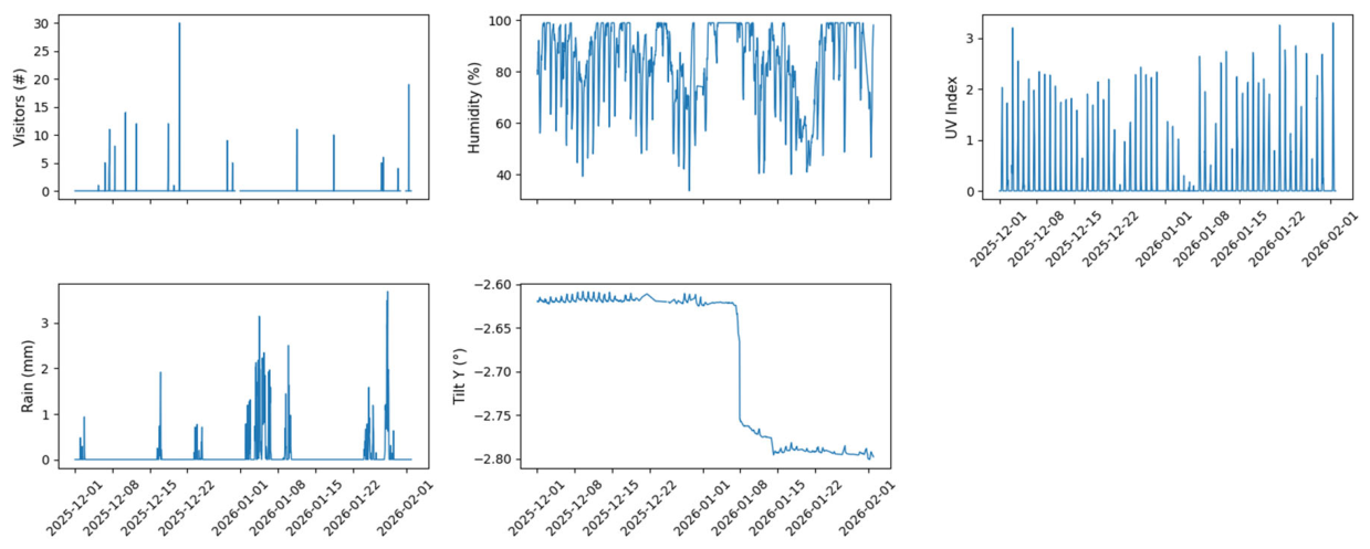
Figure 6.
Example of monitored data in Ranverso: relative humidity, soil moisture, UV index, and particulate matter concentration.
Figure 6.
Example of monitored data in Ranverso: relative humidity, soil moisture, UV index, and particulate matter concentration.
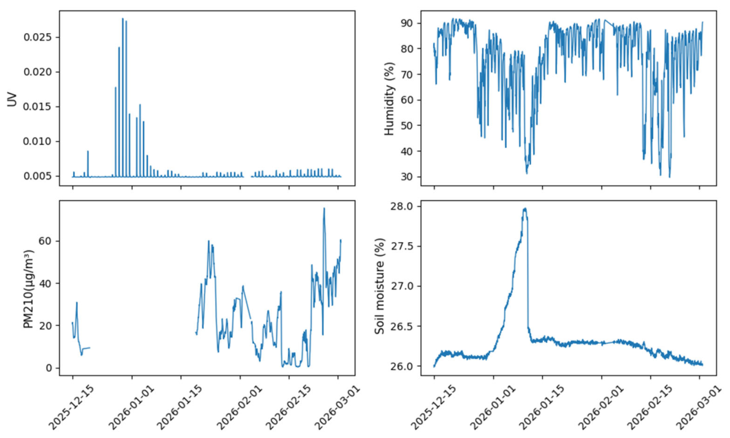
Figure 7.
Example of monitored data in Schenkenberg: temperature, wind peaks, and vibration frequency.
Figure 7.
Example of monitored data in Schenkenberg: temperature, wind peaks, and vibration frequency.

Table 1.
Heritage characteristics, identified threats, and preliminary risk-assessment scores across the five ARGUS pilot sites.
Table 1.
Heritage characteristics, identified threats, and preliminary risk-assessment scores across the five ARGUS pilot sites.
| Site | Country | Heritage Type | Main Threats | Risk assessment (3-15) |
| Delos | Greece | Archaeological site | Salinity | 10 |
| Wind erosion | 10 | |||
| Soil erosion | 9 | |||
| Rainfall | 7 | |||
| UV radiation | 7 | |||
| Baltanás | Spain | Underground cellars | Land movement/subsidence Moisture accumulation High relative humidity Flooding |
11.5 11.5 10 10 |
| Monti Lucretili | Italy | Cultural landscape | Rainfall, Anthropogenic pressures/abandonment, Land movement/subsidence UV radiation |
14.5 13.5 13 11.5 |
| Ranverso | Italy | Abbey | Moisture accumulation/ground water High relative humidity Biological colonization Air pollution UV radiation |
14 13 12.5 11 11 |
| Schenkenberg | Switzerland | Castle ruins | Freeze–thaw cycles Vegetation growth Thermal oscillations Wind erosion |
13 13 12 11 |
Table 2.
Threat to parameter to sensor.
| Threat | Measurable Parameter(s) | Monitoring Method |
| Land movement / subsidence/ soil erosion | Ground displacement, inclination, cracks and vibrations | GNSS, tiltmeter, crackmeter, accelerometer |
| Wind erosion | Wind speed and direction | Anemometer, weather station |
| Salinity | Temperature and relative humidity cycles | Temperature and humidity sensors |
| Freeze–thaw cycles | Temperature; humidity, soil moisture | Temperature sensor; moisture probe |
| Thermal oscillations | Temperature fluctuations | Temperature sensor |
| UV radiation | UV radiation intensity | UV sensor, weather station |
| High humidity | Relative humidity | Humidity sensors |
| Rainfall | Precipitation intensity and accumulation | Rain gauge |
| Flooding | Water level / presence; precipitation; moisture | Water-level sensor; rain gauge; moisture probe |
| Moisture accumulation | Material/soil moisture; relative humidity | Moisture probe; Humidity sensor |
| Vegetation | NDVI | Multispectral camera |
| Biological colonization | NDVI, acoustic emission | Multispectral camera and acoustic sensors |
| Air pollution | Gasses/PMs | Air pollution sensors |
Table 3.
Deployed sensors across the five ARGUS pilot sites.
| Category | Type | Parameters | Pilot #1 | Pilot #2 | Pilot #3 | Pilot #4 | Pilot #5 | |
| Delos | Baltanás | Monti Lucretili | Ranverso | Schenkenberg | ||||
| Enviromental monitoring | Air flow meter | Air flow in enclosed areas | ✔ | ✔ | x | ✔ | x | |
| Lux-UV meter | Light and UV incidence | ✔ | ✔ | ✔ | ✔ | ✔ | ||
| Wind speed and direction | Wind speed and direction | ✔ | ✔ | ✔ | ✔ | ✔ | ||
| Solar radiation sensor | Solar radiation incidence | ✔ | x | ✔ | ✔ | x | ||
| Rain gauge | Rainfall | ✔ | ✔ | ✔ | ✔ | ✔ | ||
| Air temperature | Air temperature | ✔ | ✔ | ✔ | ✔ | ✔ | ||
| Ambient relative humidity | Relative humidity | ✔ | ✔ | ✔ | ✔ | ✔ | ||
| Barometric Pressure | Atmospheric Pressure | ✔ | ✔ | ✔ | ✔ | ✔ | ||
| Water level sensor | Flood level | x | x | x | ✔ | x | ||
| Soil moisture | Moisture | ✔ | ✔ | x | ✔ | ✔ | ||
| Soil temperature sensor | Temperature | x | ✔ | ✔ | x | ✔ | ||
| Soil electrical conductivity | Electrical conductivity | x | x | x | x | ✔ | ||
| Tensiometer | Soil suction | x | ✔ | x | x | x | ||
| Gas detector | Several types of gases | ✔ | ✔ | x | ✔ | x | ||
| Pollutant particles detector | Several types of particles | ✔ | x | x | ✔ | x | ||
| Structural monitoring | GNSS (Global Navigation satellite System) | Vertical and horizontal displacement | x | ✔ | x | x | x | |
| Tiltmeter | Plane rotation | ✔ | x | ✔ | ✔ | ✔ | ||
| Vibration Meter | Vibration (velocity based) | x | ✔ | ✔ | ✔ | ✔ | ||
| Crackmeter | Cracks/joints displacement | x | x | ✔ | x | ✔ | ||
| Operational monitoring | People counter | Human /animal presence | ✔ | ✔ | ✔ | x | x |
Table 5.
Comparison between preliminary risk assessment and monitoring-based threat prioritization across the five ARGUS pilot sites.
Table 5.
Comparison between preliminary risk assessment and monitoring-based threat prioritization across the five ARGUS pilot sites.
| Site | Main Threats | Risk assessment | Monitored | Behavior observed | Monitoring-Based priority ranking |
| Delos | Salinity | 10 | No | Humidity fluctuations around 75 % (salinity condition) | 1 |
| Wind erosion | 10 | Yes | Sporadic strong gusts | 2 | |
| Soil erosion | 9 | Yes | Structure inclination | 3 | |
| Rainfall | 7 | Yes | Heavy sporadic rains | 5 | |
| UV radiation | 7 | yes | Over 6 in spring and summer | 4 | |
| Baltanás | Land movement/subsidence | 11.5 | Yes | Several collapses, altitude displacements, vibration not transmitted inside cellar | 1 |
| Moisture accumulation | 11.5 | Yes | Higher soil moisture in collapse regions. Rapid increase after rain. | 2 | |
| High relative humidity | 10 | Yes | >99% in some cellar regions. | 3 | |
| Flooding | 10 | No | — | – | |
| Monti Lucretili | Rainfall, | 14.5 | Yes | Heavy sporadic rains | 3 |
| Anthropogenic pressures/abandonment, | 13.5 | Yes | High number of visitors (up to 10 visitors burst) | 2 | |
| Land movement/subsidence | 13 | Yes | Sudden cracks and inclination movements | 1 | |
| UV radiation | 11.5 | Yes | Not very high due to vegetation coverage | 4 | |
| Ranverso | Moisture accumulation | 14 | Yes | Burst but not high values | 3 |
| High relative humidity | 13 | Yes | Moderate-high relative humidity | 2 | |
| Biological colonization | 12.5 | No | — | – | |
| Air pollution | 11 | Yes | High pollution related to visitor pressure | 1 | |
| UV radiation | 11 | Yes | Average close to zero | 4 | |
| Schenkenberg | Freeze–thaw cycles | 13 | No | Not regime-testable (only in winter) | – |
| Vegetation growth | 13 | No | — | – | |
| Thermal oscillations | 12 | Yes | Huge thermal oscillations in summer | 1 | |
| Wind erosion | 11 | Yes | Moderate-high wind speed | 2 |
Table 6.
Threat Packages Identified Through ARGUS Validation.
| Threat Package | Key Sensors | Representative Sites |
| Moisture Package | RH, temperature, soil moisture, airflow, water level | Baltanás, Ranverso |
| Climate Exposure Package | Weather station, UV, lux, wind, rainfall | Delos, Schenkenberg |
| Structural Stability Package | Tiltmeter, crackmeter, GNSS, vibrometer | Monti Lucretili, Schenkenberg |
| Pollution Package | Gas detector, particle sensor | Delos, Ranverso |
| Operational Package | People counter, environmental sensors | Delos, Baltanás |
Disclaimer/Publisher’s Note: The statements, opinions and data contained in all publications are solely those of the individual author(s) and contributor(s) and not of MDPI and/or the editor(s). MDPI and/or the editor(s) disclaim responsibility for any injury to people or property resulting from any ideas, methods, instructions or products referred to in the content. |
© 2026 by the authors. Licensee MDPI, Basel, Switzerland. This article is an open access article distributed under the terms and conditions of the Creative Commons Attribution (CC BY) license.
Copyright: This open access article is published under a Creative Commons CC BY 4.0 license, which permit the free download, distribution, and reuse, provided that the author and preprint are cited in any reuse.