
Submitted:
12 September 2026
Posted:
16 September 2026
You are already at the latest version
Abstract
Coastal erosion constitutes a global and alarming problem, as 70% of the shorelines are retreating. Especially in Europe, it is estimated that 15 km2 of shorelines are retreating annually while more than 5 million people live in areas threatened by coastal erosion. In this paper, the problem of coastal erosion in a characteristic coastal area from the Region of Attica in Greece is discussed, using the Drivers-Pressures-State-Impact-Responses (DPSIR) framework and the engineering resilience approach. To this direction the Resilience Index (RI) is going to be implemented taking into consideration: (1) the drivers and pressures which are expected to arise from climate change in the case study area, (2) the existing adaptation methods (state), (3) the challenges and risks (impact), and (4) the measures to deal with the problems that are applied in the selected region with its specific social and environmental situations (response). The main scope of the Directorate of Technical Works (Piraeus and Islands Regional Unit) of the Region of Attica is to apply science and engineering to configure an integrated approach to risk reduction through measures that also improve social, economic, and ecosystem resilience. Since many countries cope with similar coastal erosion problems, the ultimate scope of this paper is to contribute to sustainable global development and mitigation of climate change in the coastal erosion issues, highlighting how Engineering Geology practice and research should further evolve in a rapidly changing world.
Keywords:
engineering resilience
; coastal erosion
; resilience index
; DRSIR
; region of attica
1. Introduction
In many countries worldwide, coastal communities, ports, and marine ecosystems are under increasing stress from erosion, storm surges and environmental degradation. In particular, coastal erosion, even though it is a natural process, is viewed as a natural disaster, since it causes many different issues on the coastal infrastructures. Coastal regions house nearly 40% of the world’s population and drive major global economic activity, yet they face rising areas, stronger storms, erosion and the loss of natural buffers. These risks could affect 360 million people and generate one trillion dollars in annual losses by 2050 [1]. That is not a distant problem. It is happening nowadays. Recent papers have emphasized the increasing vulnerability of coastal areas to natural disasters through the combination of changing climate, geological processes, and continued urbanization and economic investment. The sea is rising, “swallowing” beaches, roads, houses, and infrastructure. Scientific research in recent years has already recorded cases of beaches and river mouths receding by 5, 10, and even 400 meters, often in a matter of decades. In Greece, with a total length of coastline equal to 13,676 kilometers, an approximately 30% of beaches are currently experiencing erosion. A sea level rise of 0.5 meters, which is not the most unfavorable scenario, will cause 60% of Greek beaches to recede by 20% of their maximum width and a further 15% of beaches to recede by 50% of their width. In terms of temporal scales, the issue of sea-level rise is complicated and generates a variety of environmental problems; an increase of water depth results in wave base becoming deeper and as a result waves reaching the coast have more energy and therefore can erode and transport greater quantities of sediment. Thus, the coast starts to adjust to the new sea level to maintain a dynamic equilibrium [2].
In this paper, the problem of coastal erosion in a characteristic vulnerable coastal area from the Region of Attica in Greece is discussed, using the Drivers-Pressures-State-Impact-Responses (DPSIR) framework and the process of engineering resilience approach. The strength of the framework is that problems can be identified by cause-effect interactions; drivers lead to pressures on environmental and societal issues, the pressure affects the state of those issues, resulting in outcomes (impacts) which need to be mitigated [3]. On the other hand, improving resilience, which is the ability to anticipate, prepare for, respond to, and adapt to changing conditions and to withstand and recover rapidly from disruptions with minimal damage, is a key objective of reducing risk. To this direction, the Resilience Index (RI), a proposed evaluation system, based on the rock engineering system approach [4], is going to be implemented, taking into consideration the drivers and pressures which are expected to arise from climate change in the case study area, the existing adaptation methods, the impact of these methods, and finally the measures applied in the specific region. Furthermore, the geological and geotechnical study outcomes of the Kaki Vigla coastal site located in Salamina island in Region of Attica is briefly discussed, in order to validate the proposed Resilience Index (RI). The findings emphasize that the Resilience Index can be regarded as a simple and economical tool for providing valuable insights for future coastal resilience and restoration initiatives.
2. Materials and Methods
Geomorphological Setting of the Kaki Vigla (Salamina Island, Greece)
The bay of Kaki Vigla extends along the eastern coast of the island of Salamina (Figure 1). It is a relatively small geomorphological formation, which, due to the eastern orientation of its entrance, provides relative protection to the coastal zone from southern and southeastern winds, while on the contrary, it is directly and unhindered by eastern winds [5]. The bay has distinctive geomorphological characteristics, which largely determine the coastal processes that take place in its coastal zone, as well as the size and intensity of wave action that ultimately reaches its coastline. Specifically, the bay is generally bounded by two main formations – rocky outcrops on the eastern coast of the island. As part of this study, a bathymetric survey was carried out of the northern part of the bay, where erosion problems are also evident. From the general shape of the sea floor isobaths, it appears that the propagation of waves inside the bay is almost perpendicular to the coastline, with the crests of their fronts being approximately parallel to it. This shape is characteristic of beaches with sandy sediments – i.e. those formed by granular materials that can potentially be transported by wave action. In contrast to the northern and southern boundaries of the bay, the isobaths change direction, turning towards them and forming a parallel curve that follows the outline of their rocky coastline.
Geological and Geotechnical Setting
The geological structure of the area is characterized by alpine formations of the Sub-Pindos zone, which are covered in places by Quaternary deposits. In summary, the geological formations found in the area of Kaki Vigla, from the most recent to the oldest, are: Alluvial deposits, coastal deposits, beach rocks, radiolites, ophiolites, limestones [5].
From Figure 1, it can be clearly shown an active fault that intersects the examined area in an east-west direction.
It is generally accepted that the factors that play the most significant role in the erosion of sea cliffs are: (a) the sea level rise, (b) the action of the waves and currents along the coast, (c) the lithology (strength) and structure of the slope materials, and (d) the terrestrial factors (such as weathering, surface and groundwater, winds, external loads, earthquakes, slope orientation relative to the sun, etc.).
The following points are particularly noteworthy in relation to the area under consideration. Changes in the sea level alter the frequency and duration of wave contact with the slopes of the coastline, which is the primary factor in coastal erosion and the creation of steep sea cliffs. Regarding the strength of the slope soil, this factor determines the erodibility of the soil and, in fact, based on field observations and measurements, it is even more important than the energy of the marine environment, especially in the higher parts of the slope [6].
Taking into consideration the above-mentioned, this study assessed the coastal engineering conditions in the Kaki Vigla area of Salamina island and identified the coastal processes that led to the erosion of the slope in front of the existing coastal road. The above investigation resulted in erosion control and coastal slope protection works, which were designed with criteria beyond the obvious, which is not only to stop the phenomenon and restore the safety of the road, but also to minimize the impact of the newly introduced construction on the coastal zone.
Considering the above, the following computational analyses were performed: (a) Assessment of the wave climate in the study area, (b) Wave propagation study, (c) Coastal engineering investigation, (d) Sedimentological research and analysis. Beyond numerical approaches, the coastal engineering investigation was also based on the geographical and geomorphological identification of the bay (land and coastal zone), with the help of navy charts, photographs from site visits carried out as part of the study, historical aerial photographs, and general aerial photographs obtained from the internet, from which particularly important conclusions were drawn for understanding coastal hydraulics and its processes within the marine area of the bay of Kaki Vigla. The analysis showed that: the main cause of erosion of the coastal earthen slope, and in particular the last 70 m or so of the northern beach, is the local "interruption" of the continuous rocky underwater formations near the coastline. The above-mentioned are furthermore clarified as follows [5]:
Location 1 – Coastal Slopes with Undercuts
A coastal road runs along the coastal slopes of the settlement of Kaki Vigla, with a length of approximately 400 m and a width ranging between 3.50 and 5.50 m. In the western part of the study area, undermining and failures have been recorded on the coastal slopes of the coastal road. In this section, there is a narrow sandy beach with low slopes ranging from 1.0 m to 6.5 m in height, which are almost vertical. In conditions of strong westerly winds, the narrow width of the beach allows the waves to reach the slope and erode it. The unimpeded action of the waves has caused significant undermining of the slope in three locations and a gradual retreat of its front, limiting the usable width of the coastal road upstream (road narrowing by approximately 0.50-1.00 m) and endangering the movement of vehicles and pedestrians on it. A coastal engineering study was conducted to assess the coastal engineering conditions in Kaki Vigla and to investigate the erosion processes that occurred in front of the embankment and the coastal road. Four (4) basic proposals were examined in this study: (a) Construction of a coastal protection project (Proposal A), (b) Construction of a stepped structure on the coastal front (Proposal B), (c) Construction of a reef breakwater in the near coastal zone (Proposal C) and (d) Construction of a mild intervention and restoration of the undercuts (Proposal D). The first two solutions, either separately or in combination, eliminate the use of the beach, while the third proposal is considered prohibitively invasive in the coastal zone, due to the underwater structures. The same study also proposed a mild intervention solution with local interventions at the erosion sites and monitoring of the slope response (Proposal D), which is not dimensioned. This proposal should be combined with measures to reinforce and protect the road in case of failure of the coastal slope. Taking into account the results of the geological study, the geotechnical investigation and assessment, and the coastal engineering study, in order to stabilize and restore the undermined areas, the protection of the coastal slope, and the securing of the upstream coastal road, the solution of mild intervention of the port study (Proposal D) was selected, in combination with technical reinforcement of the coastal road. This technical solution was chosen to minimize interventions in the coastal zone and maintain the use of the beach by swimmers. More specifically, the following are proposed: (i) Removal and collection of rocks from the existing riprap in a suitable area, so that they can be used for the construction of the new riprap, (ii) Restoration of the undermined foot of the slope with concrete gabions and filling with cast concrete, (iii) Construction of a protective riprap at the foot of the slope over a limited area, (iv) Reinforcement of the coastal road with a micro-pile reinforcement technique, which will function in the extreme case of failure of the downstream coastal slope and (v) Monitoring after construction.
Location 2 – Small Beach Slopes
In the northern part of the coastal slopes in the settlement of Kaki Vigla, there is a small sandy beach, which is used by bathers during the summer months. Behind the beach, there is a steep slope approximately 20 m high, which is covered with unconnected gravelly slope deposits that have formed a debris cone and come from the weathering and erosion of the upstream formations and the overlying cohesive debris. The presence of the debris cone indicates the frequent detachment and fall of small stones and gravel from the upper part of the slope at its base. In the event of heavy rainfall or seismic loading, limestone slabs or pieces may detach from the upstream debris and slide onto the beach, endangering the safety of bathers. Rockfalls and landslides may occur on the slope in question during heavy rainfall or seismic activity. Due to the use of the beach by swimmers during the summer months, protection from these potential falls is required. Specifically, the proposed protection system includes the following (in chronological order of works): (i) Removal of loose debris covering a large part of the slope, (ii) Removal of any unstable rocks from the front of the slope, (iii) Installation of permanent anchors at 3 m intervals at the top of the slope. Additional anchors 3.00 m long are recommended to be installed every 3.00 m at locations where the slope changes significantly, (iv) Covering of the slope face with free composite steel mesh, with additional polymer coating. Inside the composite steel mesh, an additional hexagonal mesh with a loop size smaller than 1" will be installed.
The DPSIR Framework Applied to the Case Study Region
In 1999, the European Environmental Agency (EEA) developed the “Drivers-Pressures-State-Impact-Responses” (DPSIR) framework, which is based on a concept of causality and describes the interactions among human activities (society) and the environment (e.g., environmental pressure, the state of the environment and environmental responses) as cause and effect relationships that can be represented through indicators-parameters [7]. DPSIR is not a model, but a means of categorizing and disseminating information related to particular environmental challenges [3]. This framework is closely related to the meaning of resilience in civil engineering projects which in turn is associated with the preparedness and response of a system against catastrophic events. Preparedness is basically related to the ability to proactively mitigate the effects of disastrous events by providing adequate resources and designing strategies before disruption. The term “response” includes the meanings of “absorption” and “recovery”, where they both are expected after the event of disruption. Absorption is the immediate response of an infrastructure system in which the system withstands the disruption, and recovery is the organizational efforts to rapidly repair the damaged system and the consequential effects propagated to other systems [8].
Bruneau et al. [9], further described the meaning of resilience by defining four properties: robustness, rapidity, resourcefulness, and redundancy. Robustness is the ability of technical works to resist the impact of hazard events, such as coastal erosion, landslides, floods, etc. Rapidity is associated with how quickly the infrastructure recovers after an event, which depends on the available resources and the damage level. Resourcefulness is the capacity to identify problems, establish priorities, and mobilize resources (i.e., monetary, physical, technological, and informational resources). Furthermore, resourcefulness can contribute to developing mitigation measures for disaster prevention and contribute to the recovery process. For example, sufficient monetary and informational resources reduce the time in identifying damages or vulnerability of the system. Redundancy indicates the extent to which existing elements or systems are substitutable. Redundancy and resourcefulness are the means to improve the resilience of an infrastructure. The same researchers, Bruneau et al. [9], further categorized resilience within the engineering discipline into different dimensions, such as technical, organizational, environmental, social, and economic. The technical dimension includes all the technological issues related to the construction; the organization dimension includes all the management activities and response to emergencies; the environmental dimension is associated with the influence of the constructed technical works on the surrounding environment; the social dimension considers the impacts of failure of infrastructure system to social groups; and the economic dimension refers to economic losses, because of the occurrence of the disaster, as well as the subsequent rehabilitation.
Based on the above, a resilient system should be characterized by the following: reduced failure probabilities, reduced consequences from failures, and reduced time to recovery. Coming back to the DPSIR framework, ‘Drivers” comprise processes which formulate human activities and affect the environment. The driving forces result in “Pressures”, which can be identified as the effect of climate change or funding constraints [8]. “States” include the robustness, rapidity, resourcefulness, and redundancy of the examined infrastructure. The states indicate the metrics that represent the resilience of a civil engineering project. An example of this will be presented in the following section by quantifying the resilience through a matrix table and an index. The technical, economic, organizational, environmental, and social effects can be described by the impacts. Lastly, disaster management and decision-making are associated with the term ‘response’, which will be described by mentioning the series of civil engineering construction that are needed for the restoration of the Kaki Vigla’s coastal case study area.
Quantitative Framework to Evaluate Resilience
The performance evaluation method is a crucial approach for quantifying coastal resilience. In this study, the RES (e.g., Rock Engineering System) approach, a semi-quantitative methodology and a matrix table proposed by Hudson [4], was used, in order to evaluate the effectiveness of the above-described mitigation measures for improving the resilience of the geological–geotechnical environment of the examined case study. To this direction, the Resilience Matrix (RM) is consisted of an 8 × 8 table (Table 1), where the basic principle is to place the most important parameters of any system (e.g., technical, environmental, social and economic) and the steps of a disruptive event (preparation, absorption, recover, adaptation) along a principal diagonal and to study the interactions of the selected parameters outside the principal diagonal, through a cause–effect relationship [8]. In our case study (coastal erosion problem), the technical parameter aims to minimize the probability of failure in case of a severe meteorological or geohazard event. On the other hand, social, environmental, or economic parameter can be the (derivative) impacts (e.g., positive or negative, overestimated or underestimated, respectively) of technical resilience.
To perform a resilience assessment and understand an adverse event (e.g., the consequences of a coastal erosion to the tourism income of a summer resort), the following steps should be taken: (i) definition of the system boundary (e.g., road/coastal slope adjacent to the sea) and threats (e.g., natural disaster: slope failures, subsidence and undermining of the coastal slopes), (ii) identification of the driving forces, existing and relevant pressures, (iii) selection of indicators (meaning that each cell of the matrix acts as a value of how well the system behaves) implementing expert judgement on a relative numerical scale from 0 (being the least resilient or having the highest impact), 1 (low), 2 (medium), 3 (high) to 4 (very high resilient), (iv) assessment of the overall resilience of the system by aggregating the cells scores across the matrix (Table 2).
How is the Resilience Matrix Working?
Taking into consideration that the most critical function is the coastal resilience of Kaki Vigla area, while maintaining the post-construction terrain stability, the technical–absorption cell is assigned a rating according to the ability of the system to withstand any new storm surge, flash flood, coastal-tidal flood or tsunami episode in such a way that will be able to resist from potential failures similar to those that resulted in the coastal erosion before the civil engineering mitigation measures took place. To succeed in accomplishing that in the case study area, building codes, construction procedures, numerical models and engineering analyses took place during the working out of the geotechnical study of the case study area, taking into consideration different alternative scenarios regarding the occurrence of extreme weather events. Another example is the interaction between economics and recovery. In this, a rating is assigned based on the assumption that the size of the potential slope failure would adjust the time of the repair works needed for the stabilization of the examined slopes. Regarding the interaction between technical and social parameters, the citizens’ perception of the surrounding examined area is estimated to be positive, because minor new technical mitigation works will be required. In this direction, the interaction between economic preparation will lead to less budget than the one needed for the initial restoration of the slopes. Considering the environmental impact, slope failures, and undermining will be restored, resulting in the environmental restoration of the area examined. Studying the interaction of environmental–social aspect of resilience, the proposed designed mitigation measures will contribute to the development of touristic facilities of the coastal area. Studying the relationship between social factors and preparation, public safety, and quality of life is connected to how well-prepared society is, because the absence of preparation in the face of a natural hazard is associated with the lack of understanding and information on the effects of a disruptive event. On the other hand, speaking about the relationship between social and absorption, one could say that the restoration of the coastal slopes can improve the vacation time for the visitors of the coastal area as well as the feeling of being safe regarding the permanent residents of the surrounding area. As far as the relation between social and adaptation is concerned, it can be highlighted that the closure of the coastal area due to the civil engineering restoration works partially may affect the local traffic and, as a result, the access to social needs such as emergency services or medical care. The above-mentioned remarks are quantified in the following Figure 3, which depicts the ratings for each cell of the resilience matrix, estimated by an expert (here, by the author of this manuscript), considering the improved geotechnical conditions of the examined study area after the implementation of the mitigation works. The rating for each interaction has been assigned, for example, as follows: The technical parameter has a critical influence on the environment, as represented by value 4. Concerning the influence of the social parameter to environment, there is no interaction (rating equal to 0). For a better understanding of the interactions between the selected parameters, the reader is advised to read the following references [4,8].
For the validation of the Resilience Index, the Building Resilience Index (BRI) which is an innovation of the International Finance Corporation (IFC), a member of the World Bank Group, was used, making some appropriate adjustments to take into consideration the in situ geodata from the examined study area, as well as the internationally accepted standards and codes about civil engineering technical works (IFCWBG, 2024), [10]. The Building Resilience Index (https://resilienceindex.org, accessed on 30 August 2026) is a resilience assessment approach, and its objective is to provide a simple tool for engineers to identify and address risks for infrastructure projects. BRI offers a relative rating of resilience from higher to lower and to motivate experts to reduce physical risk, rather than an absolute rating against some standard of performance. It is understood that even the highest levels are not 100% resilient but retain certain residual risks. BRI can be of use and benefit to multiple stakeholders such as: (a) Designers and Construction Developers, (b) Banks, (c) Insurance Companies, and (d) Governments and Local Authorities. BRI is organized around the four major hazard categories that infrastructure projects experience: wind, water, fire, and geoseismic. In our case study, BRI has been adjusted, and it will be used for the water (e.g. coastal erosion, tidal flood, storm surge, tsunami) and the geoseismic (e.g. landslides, subsidence, earthquakes) hazard categories in relation to infrastructure (e.g. civil engineering) mitigation measures.
Methodology
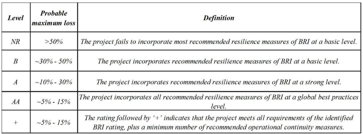
BRI uses the rating scale as shown in the following Table 3. Rating refers to the risk-reduction measures that the infrastructure incorporates and is not predictive of the infrastructure behavior during a natural disaster or climate change event. These ratings are part of the outputs of the application, which are explained in the following sections. According to the ’weakest link’ principle, the infrastructure rating is determined by the lowest score achieved per hazard indicator. For example, if three out of the four hazard indicator categories achieve a rating of A, but in the fourth category the rating is B, then the overall building rating will be B. An infrastructure that achieved a rating above NR on all the available hazard indicators—categories can obtain a “+” next to the rating, such as A+, by implementing at least three operational continuity measures.
For the evaluation of the BRI, the best practice standards for geoseismic hazards are considered those from: (a) NASA Global Landslide Catalog (GLC), (b) United States Geological Survey, (c) European Soil Data Centre (ESDAC), (d) Norwegian Geotechnical Institute and (v) United Nations Office for Disaster Risk Reduction [10]. The following risk reduction measures/hazard indicators list is in BRI and forms the basis for the BRI geoseismic rating. Measures marked ‘Y’ apply if the project is in a location with that hazard type. Projects that do not obtain an AA, A, or B rating are rated NR. Defining in depth the above-mentioned hazard indicators for the estimation of BRI of a project, such as the case study of Kaki Vigla’s coastal area, it can be said that [10]:
GS01. 1 km Distance from Earthquake Fault or Seismically Designed/Built (B Rating): In areas prone to earthquakes or landslides, if the infrastructure does not include the seismic measures required for AA or A rating, it must be located more than 1 km away from an earthquake fault or designed/built to site-specific seismic study in conformance with the national seismic code, if applicable. It is important to note that any earthquake fault line located within 1 km of a site will represent high risks. In the examined area, the nearest active fault is less than 1 km from the coastal slope site (Figure 1).
GS02. Foundation Seismically Designed for Site-Specific Soil Conditions (A Rating): The ground conditions are of great importance in the stability of the infrastructure. Ground deformation can damage foundations. The foundations of any infrastructure must be designed to withstand seismic forces near fault lines. If the infrastructure site is composed of filled rock or soil, it cannot be rated AA or A, unless either the foundation extends below the filled section into hard rock. In the case study, micro-piles reinforcement technique, permanent anchors, and free composite steel mesh constitute the reinforced geotechnical profile and stabilize the examined coastal area of the project.
GS13. Defensive Structures for Landslides (AA Rating): Defensive structures for landslides are to be incorporated within the infrastructure premises to protect them from slope failures and subsidence. These should be properly designed and inspected by a geotechnical engineer, considering the in situ geological–geotechnical conditions. Examples of defensive mitigation structures, such as micro-piles reinforcement technique, permanent anchors, and free composite steel mesh, are the technical measures that have been implemented in the examined coastal area.
Regarding water hazards, Global Best Practices (GBP) for flood and storm surge water hazards are considered those of the Netherlands [10]. The flood risk legislation of the Netherlands prevents municipalities from building in flood plains along rivers and coastal zones. Buildings permitted in flood-prone locations are elevated on piles or adjusted to water levels. Tsunami standards in Japan are considered GBP’s. Following the Tsunami Evacuation Building Guidelines (2005), the Ministry of Lands, Infrastructure, Transport and Tourism of Japan (MLIT) proposed the ‘Interim Guidelines on Structural Requirements for Tsunami Evacuation Buildings’ [10]. The following risk reduction measures/hazard indicators list is in BRI and forms the basis for the BRI water hazard rating. Defining in depth the above-mentioned hazard indicators for the estimation of BRI of a project, such as the case study of Kaki Vigla’s coastal area, it can be said that [10]:
WT02. Not Located at the Low Point of a Valley or Gully (AA Rating): In areas prone to river, local, or flash flooding, the location of an infrastructure should not be less than 6m above the lowest point of a valley or gully for an AA rating. Water flows with the force of gravity, from high to low, carving pathways in the terrain that it uses repeatedly or seasonally. Therefore, these pathways will become filled with water again and will overflow and flood, causing destruction to any buildings within their vicinity. In the examined coastal area, and according to Figure 1, the above-mentioned are not verified. Furthermore, the existing hydrographic network crosses the north part of the coastal area, resulting in surface erosion and accelerates the dynamic procedure of the adjacent coastal erosion. Thus, the appropriate rating for this case is equal to B.
WT10. If Near Water Defense Infrastructure, the Lowest Occupied Level is Elevated at least 3 m (or 5 m for Tsunami) – (B Rating). The proposed mitigation measures in the coastal area of Kaki Vigla are at least 3 m (or 5 m in tsunami hazard areas) above sea level.
WT19. Resistance to Impact of Water-Borne Debris (A Rating): Moving water can carry debris, which at higher velocity can cause severe damage upon collision, potentially tearing into walls, bending columns and causing collapse. If the ground elevation is less than 5 m above sea level, the infrastructure must be designed/built to have features (e.g. piles) that reduce debris impact.
Taking into consideration the ’weakest link’ principle of the previously mentioned hazards (geoseismic and water), the BLI rating for the examined infrastructure is determined by the lowest score achieved per hazard indicator, which is category B equal to 30% (theoretically up to 50) probable maximum loss. To this extent, the expected outcome coincides with the Resilience Index (e.g., RI = 69.35~70) which came out from the RES approach, as analytically described before. This means the project incorporates recommended resilience measures of BRI at a basic level.
3. Discussion
The DPSIR framework, adopted by the European Environment Agency (EEA, 1999), is used for environmental assessments and assumes cause-effect relationships between interacting components of social, economic and environmental systems. As Karageorgis and his co-authors (2005) point out [11], to understand the cause–effect relationships related to a particular environmental issue, one must focus on the interactions between the different categories (Driver, Pressure, State, Impact, Response).
As mentioned before, the selected parameters for the estimation of Resilience Index were based on the implementation of the DPSIR framework. It is regarded as a philosophy for structuring and communicating policy-relevant research about the environment. Thus, the “drivers” (e.g., driving forces), in our case study are the coastal slope, its adjacent road and the surrounding houses which are associated with the population and coastal tourism. “Pressures”, are the coastal erosion, the intense faulting which accelerate the coastal erosion and possible tsunami. Another type of pressure could be an incident of an earthquake or an episode of heavy rainfall resulting in (flash) floods, landslides, and undermining near to the examined coast. Regarding the “states”, they are correlated to robustness, rapidity, redundancy, and resourcefulness. Robustness in our case study is associated with the estimation of bearing capacity and instability index. Rapidity concerning time is correlated to how fast bureaucratic procedures (e.g., agreement for the beginning of the project, searching for extra budget) are going to be completed to fulfill the civil engineering mitigation works in the examined area. Redundancy is related to a possible supplementary study, which may be needed in case of unexpected rainfall episodes that can take place during the reconstruction works. Finally, resourcefulness is the cost required for the restoration of the coast. As far as “impacts” are concerned, these are the construction costs for mitigation and repair. Finally, “responses” are associated with the mitigation measures that have been designed (e.g., concrete gabions, construction of a protective riprap, micro-pile reinforcement implementation, monitoring after construction).
According to the previously mentioned, the resilience matrix (RM) allows the use of both qualitative and quantitative data in the resilience scoring process. In addition, RM is adaptive enough to be used as a tool, considering any level of data availability, but detailed enough to support decision-making [12]. Thus, improving the resilience of geotechnical engineering structures and preventing them from large-scale collapse to small-scale damage in unexpected conditions is of great importance to the safety of the infrastructure, the citizens, and society in general. As a result, the present study can contribute to the implementation of EU Directives by fostering a culture of preparedness and proactive risk management [8].
4. Conclusion
Coastlines, now and even more so in the future, are especially vulnerable to threats posed by tides and coastal storms, due to geological processes, changing climate and ongoing development. Taking care of the coastline is like taking care of a living thing. It takes constant work, the ability to adapt and a deep understanding of how natural processes and human actions affect each other. The main conclusion of this paper is that reasonable planning and design are essential prerequisites for appropriate coastal resilience projects. To this end, DPSIR framework provides the ability to compare the policy procedures, and the effectiveness of the adaptation measures of the examined coastal area towards sustainable development.
5. Acknowledgments
The work is dedicated to the memory of the Emeritus Professor Georgios Koukis (1943-2025), one of the first pioneer Greek geologists who contributed to a large extent to the establishment of Engineering Geology in Greece.
Author Contributions
Conceptualization, N.T. and A.K.; methodology, N.T.; software, N.T.; validation, N.T.; formal analysis, N.T.; investigation, N.T.; resources, N.T.; data curation, N.T.; writing—original draft preparation, N.T. and A.K.; writing—review and editing, N.T. and A.K..; visualization, N.T. and A.K.; supervision, N.T.; project administration. All authors have read and agreed to the published version of the manuscript.
Funding
This research received no external funding.
Data Availability Statement
Acknowledgments
This paper is based on the findings from the geological and geotechnical study executed for the coastal landslide phenomena on the island of Salamina belonging to the Regional Authority of Attica. The author would like to express his gratitude to: (a) the Department of Technical Support of Attica’s Region Municipal Islands, Directorate of Technical Works Piraeus and Islands, Regional Authority of Attica for providing him with technical reports and photographs, and (b) the NAMA Engineering Consultants, the designer of the restoration works. The authors have reviewed and edited the output and take full responsibility for the content of this publication.
Conflicts of Interest
The authors declare no conflicts of interest.
References
- Bruneau, M.; Chang, S.; Eguchi, R.; Lee, G. A framework to quantitatively assess and enhance the seismic resilience of communitie (2003). Earthq. Spectra 19, 733–752. [CrossRef]
- EEA - European Environment Agency. Environmental indicators: Typology and overview. Technical report No. 25; Copenhagen, EEA, 1999.
- de Puydt, L.; Gladytz, A.; Karrasch, L. Developing sustainable coastal areas: A comparison between the Netherlands and the United Kingdom. In Environmental Science; 2017. [Google Scholar]
- International Finance Corporation; World Bank Group (IFCWBG). Building Resilience Index. User Guide, version 1.5.0. 12 November 2024. Available online: https://resilienceindex.org (accessed on 30 August 2026).
- Hudson, J. Rock Engineering Systems: Theory and Practice; Ellis Horwood Limited: Chichester, UK, 1992. [Google Scholar]
- Karageorgis, A.P.; Skourtos, M.S.; Kapsimalis, V.; Kontogianni, A.D.; Skoulikidis, N.T.; Pagou, K.; Nikolaidis, N.P.; Drakopoulou, P.; Zanou, B.; Karamanos, H.; Levkov, Z.; Anagnostou, Ch. An integrated approach to watershed management within the DPSIR framework: Axios River catchment and Thermaikos Gulf. Reg. Environ. Change 2005, 5(2), 138–160. [Google Scholar] [CrossRef]
- Linkov, I.; Eisenberg, D.A.; Bates, M.E.; Chang, D.; Convertino, M.; Allen, J.H.; Seager, T.P. Measurable resilience for actionable policy. Environ. Sci. Technol. 2013, 47, 10108–10110. [Google Scholar] [CrossRef] [PubMed]
- Massachusetts Institute of Technology. Building Coastal Resilience; 77 Massachusetts Avenue, Cambridge, MA, USA, 2025. [Google Scholar]
- NAMA CONSULTING ENGINEERS AND DESIGNERS S.A. Geological and Geotechnical Factual and Interpretation Report of landslide phenomena on the island of Salamina (areas of Porto Fino, Kaki Vigla, etc); unpublished technical report; Directorate of Technical Works, Region of Attica: Piraeus, Greece, 2023. [Google Scholar]
- Tavoularis, N. Towards the Resilience of Attica Region’s Provincial Road 3 in Greece, Due to Slope Failure by Applying Civil Engineering Techniques and a Semi-Quantitative Assessment Approach. Appl. Sci. 2025, 15(18), 9874. [Google Scholar] [CrossRef]
- Tien, Pham Hoan; Sam, David Dwight. CHAPTER 4 PROTECTION FROM COASTAL EROSION Thematic paper: The role of coastal forests and trees in protecting against coastal erosion. In Environmental Science; 2007. [Google Scholar]
- Xeidakis, S. Sea cliffs in semi-lithified soils. Part A. Erosion mechanisms and types of failures. 5th Hellenic Congress of Geotechnical Engineering, Technical Chamber of Greece, Xanthi, 31/5-2/6/2006; 2006. [Google Scholar]
Figure 1.
On the left, the geological map of the examined case study is depicted. On the right, the two locations (1 & 2) of the examined area are shown.
Figure 1.
On the left, the geological map of the examined case study is depicted. On the right, the two locations (1 & 2) of the examined area are shown.
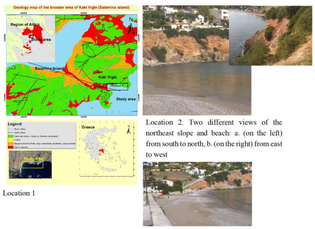

Table 1.
Resilience matrix template.
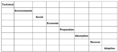 |
Table 2.
Resilience matrix after the restoration of Kaki Vigla's coastal area.
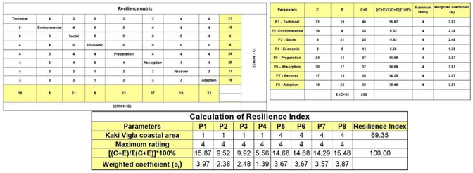 |
Table 3.
BRI rating level descriptions (IFCWBG, 2024, modified).
 |
Disclaimer/Publisher’s Note: The statements, opinions and data contained in all publications are solely those of the individual author(s) and contributor(s) and not of MDPI and/or the editor(s). MDPI and/or the editor(s) disclaim responsibility for any injury to people or property resulting from any ideas, methods, instructions or products referred to in the content. |
© 2026 by the authors. Licensee MDPI, Basel, Switzerland. This article is an open access article distributed under the terms and conditions of the Creative Commons Attribution (CC BY) license (http://creativecommons.org/licenses/by/4.0/).
Copyright: This open access article is published under a Creative Commons CC BY 4.0 license, which permit the free download, distribution, and reuse, provided that the author and preprint are cited in any reuse.