

Submitted:
10 September 2026
Posted:
14 September 2026
You are already at the latest version
Abstract
Agriculture underpins rural livelihoods in Cambodia, where roughly 1.85 million holdings across 3.2 million hectares are overwhelmingly smallholder, averaging 1.7 hectares each. On plots of this size, field scouting is still performed on foot: the method is slow, physically demanding, and epistemically limited, as the observer sees the crop from within the canopy and localised pest, weed, or irrigation problems are noticed only once they grow conspicuous from ground level. A second gap concerns memory, as the location of an outbreak is retained informally and is generally unrecoverable on a return visit. Commercial agricultural unmanned aerial vehicles (UAVs) address both limitations but are priced for enterprise-scale operations and cannot be justified across a 1.7-hectare holding. This paper presents AgriMap, a low-cost aerial field-monitoring platform pairing an open-hardware F450 quadcopter with an automated routine that triggers the camera every five seconds, stamping each frame with latitude, longitude, altitude, and battery state. Frames are stored in a Laravel and MySQL backend and rendered as interactive Leaflet markers over a field basemap, producing a persistent, searchable inspection record. Mission logic and operator workflow were validated in a Unity simulation prior to deployment. The system was assembled for USD 256.70, and all hardware specifications and dashboard source code are released openly.
Keywords:
agricultural UAV
; precision agriculture
; low-cost drone
; F450 quadcopter
; Pixhawk
; geotagging
; field mapping
; smallholder farming
1. Introduction
Agriculture remains a foundation of rural livelihoods in Cambodia. The 2023 national agricultural census identified approximately 1.85 million agricultural holdings across 3.2 million hectares, with 54.2% of all households engaged in agricultural activity [1]. The sector is overwhelmingly smallholder in structure: the average landholding measures 1.7 hectares, nearly 44% of holdings operate on less than a single hectare, and rice accounts for roughly two-thirds of total cropped area. On holdings of this size, field scouting is still performed almost entirely on foot. Walking a paddy or crop plot is slow and physically demanding, but its more serious limitation is epistemic rather than physical: the observer sees the crop from within the canopy and at close range. Localised problems such as a pest focus, an emerging weed patch, a waterlogged corner, or a blocked irrigation channel are identified only once the affected area has grown large enough to be conspicuous from ground level, by which point the damage is established and the window for a small, targeted intervention has usually closed.
Unmanned aerial vehicles (UAVs) address precisely this limitation, compressing hours of walking into minutes of flight and revealing within-field spatial variability that is not visible from inside the crop [2]. Their low flight altitudes capture very-high-resolution imagery at user-determined intervals and are far less affected by cloud cover than satellite platforms, while their relatively low cost, compared with satellite or manned aircraft, makes them accessible in the resource-constrained settings typical of smallholder farming [16,17]. The obstacle to adoption is therefore not technical feasibility but economics: commercial agricultural UAVs are engineered, certified, and priced for enterprise-scale operations, with entry-level agricultural systems commonly costing several thousand to twenty thousand US dollars depending on sensor configuration, an expenditure that cannot be recovered across a 1.7-hectare holding. Commercial platforms such as DJI and MikroKopter remain costly even for the professionals who advise smallholder farmers, which has motivated a shift toward open-source and do-it-yourself alternatives [14]. The result is a capability gap with an uncomfortable shape, in which the technology best suited to small, intensively managed, spatially heterogeneous plots is priced for the farms that least resemble them. A second and less discussed gap concerns memory rather than observation: even when a problem is correctly identified during scouting, its location is retained informally, so that on a return visit weeks later, or at the same growth stage the following season, the precise position of the earlier outbreak is generally unrecoverable. Knowledge that should compound across seasons instead resets with each one.
AgriMap addresses both gaps together. It pairs an open-hardware F450 multirotor, assembled from commodity components at a small fraction of commercial platform cost, with an automated interval-based capture routine that geotags every frame, and a Laravel web dashboard that stores those frames as a searchable, map-indexed inspection history. The objective is not to replicate a commercial survey aircraft, but to establish the minimum viable system that moves a smallholder from undocumented field walking to a persistent, spatially referenced record of their own land, and to report honestly what such a system can and cannot deliver.
1.1. Problem Statement
Five key gaps currently limit Cambodian smallholder farmers: (1) time and labour inefficiency, as manual inspection of large plots demands physical effort and takes time away from vital farm activities; (2) a high cost barrier, since enterprise agricultural drones are expensive and built for large farms; (3) no location memory, as farmers struggle to recall the exact locations of pest outbreaks, weed patches, or irrigation issues during follow-ups; (4) no affordable platform combining aerial imagery with GPS-based field mapping; and (5) no digital records, since inspection notes are informal or unrecorded, causing historical farm data to be lost season to season [1].
1.2. Objectives
The main objective is to develop a low-cost, drone-based agricultural inspection and field-mapping system that improves field-inspection efficiency and spatial visibility for small-scale farmers. The specific objectives are to design and assemble a modular F450 agricultural quadcopter platform; integrate the frame, brushless motors, electronic speed controllers (ESCs), and lithium-polymer power supply; integrate a 32-bit Pixhawk flight controller with GPS telemetry; build an automated image-capture trigger during flight paired with GPS tagging; develop a Laravel-based web dashboard to store inspection history, generate digital reports, and display telemetry such as battery percentage and altitude; plot captured images as interactive markers on a field map; and document the full development, calibration, and field-deployment process.
1.3. Scope
The present scope includes manual drone flight control using a radio controller, automatic image capture every five seconds, real-time logging of GPS coordinates, altitude, and battery level, full F450 frame assembly and Pixhawk hardware integration, a Laravel web dashboard providing user authentication, mission management, an image gallery, flight-telemetry panels, interactive Leaflet.js mapping, and automated inspection-report generation, together with flight testing and telemetry calibration. Deferred for future work are AI-based crop-disease and weed detection, fully autonomous flight pathing with dynamic obstacle avoidance, automatic pesticide and fertiliser spraying, and thermal or multispectral predictive crop-health analytics.
2. Related Work
Low-cost multirotor construction for field monitoring is now a well-documented practice. Community build logs for the F450 airframe integrating APM/Pixhawk autopilots, GPS modules, and FlySky radio control demonstrate practical assembly, PID tuning, and Return-to-Launch failsafes, and establish the F450 as a reliable low-cost base for experimentation [3]. Quadrotor configurations are generally preferred over helicopters for agricultural use because of their simpler mechanics and greater robustness [12], and open-hardware multicopters have been deployed for smallholder farming with payload capacities of roughly 1.5 kg and flight durations of 15–18 minutes [14]. Even simple, commercially available equipment can produce professional-quality orthophotos, 3D surface models, and normalized difference vegetation index (NDVI) mosaics for farming applications [21]. In parallel, an open-source ecosystem has grown around converting the imagery such platforms produce into actionable maps: photogrammetry toolkits assemble GPS-tagged aerial photos into orthomosaics and point clouds, while coverage-path-planning libraries such as Fields2Cover generate complete grid survey routes for agricultural vehicles [4]. AgriMap deliberately positions itself upstream of these tools, producing the geotagged, spatially indexed image record that they consume.
Within precision agriculture, UAVs have been reviewed extensively as a platform class. Surveys categorise multirotor and fixed-wing configurations, imaging payloads, and field-mapping workflows, and consistently identify small, intensively managed plots as the setting where within-field spatial information is most valuable [2]. A recurring finding is that the barrier to smallholder adoption is economic rather than technical: low-cost aerial acquisition systems for low-altitude monitoring have been demonstrated repeatedly, serving as direct precedents for AgriMap’s cost structure [5]. Georeferenced aerial imagery collected by UAVs is routinely mosaicked into full field maps that support precision-agriculture decisions [12,22], and the integration of geospatial cloud-computing platforms such as Google Earth Engine now enables sophisticated image analysis without proprietary software as well as dynamic web-based apps that communicate results to a wide range of users [17]. Open-source processing tools such as OpenDroneMap further reduce operational costs for expert and non-expert users alike [17]. A fully open-source workflow spanning data acquisition, processing, and an interactive webGIS has been demonstrated for a Northern Italy vineyard, producing 3 cm-resolution orthophotos and 95% classification accuracy for phenological stages [13]; such free and open-source software directly addresses two of the main limitations of smart farming on real farms, namely the cost of storing and analysing data and the release of private data to commercial companies [13]. In a related case, a low-cost UAS combined with open-source GIS tools achieved 0.01 m/pixel orthomosaics and cut herbicide treatment to 3.47% of the field area through prescription maps [20]. Work on GPS-denied navigation using visual-inertial odometry further highlights the operational risks of flight near tree lines, where satellite lock can drop, motivating conservative flight envelopes for affordable platforms that lack redundant positioning.
Deployments in genuine smallholder settings—typically holdings of less than 2 ha that contribute disproportionately to food production yet lack the resources of commercial farms [17]—report encouraging outcomes. UAV-based crop mapping has achieved 91% overall accuracy at 0.50 m spatial resolution using Google Earth Engine for land-use/land-cover classification [17], and a scoping review of 23 peer-reviewed articles found that UAVs in smallholder farms have been used mainly for monitoring crop growth, guiding fertiliser management, and crop mapping [18]. A low-cost IoT–UAV platform deployed on a farm in Medenine, Tunisia collected environmental data via ground sensors hourly and relayed it to the cloud by drone every 12 hours to support precision-agriculture decisions [11], while open-source multispectral sensors (IMAGRI-CIP) achieved NDVI values highly correlated with commercial cameras (R² ≥ 0.8) and over 82% accuracy in identifying 13 crops in smallholder plots in Kilosa, Tanzania [14]. Farm size remains a primary driver of technology adoption, so reducing cost is central to serving smaller, less technology-oriented farms [20].
These systems are not without limitations. UAVs remain unevenly adopted, especially on small farms, owing to high data-storage demands, inconsistent ground sampling distance, and the need for careful camera calibration with ground control points [16]; further effort is required to make the tools user-friendly for the full range of end-users, with a fully automated pipeline spanning flight preparation, execution, and data processing and interpretation as the eventual goal [16]. Nonetheless, continuing technological advances and falling ownership and operating costs give reason for optimism about future UAV applications informing policy, planning, and operational decisions in smallholder agriculture [18]. AgriMap is positioned within this trajectory as a deliberately minimal, low-cost step toward that goal.
Table 1 summarises how AgriMap relates to representative prior systems. AgriMap’s contribution is not a novel airframe or a new sensing modality but the end-to-end integration of a commodity quadcopter, an interval-based geotagging routine, and a persistent web dashboard into a single workflow priced for a 1.7-hectare holding.
3. Materials and Methods
3.1. System Architecture
AgriMap is organised as two coupled layers. The hardware layer is an F450 quadcopter carrying a Pixhawk-class flight controller, a GPS and compass module, a radio link, and a companion computer that triggers the camera and stamps each image with position data. The software layer is a Laravel and MySQL web dashboard that ingests those geotagged frames and renders them as interactive Leaflet.js markers over a field basemap, exposing mission management, an image gallery, telemetry panels, and automated report generation [6]. The flight controller reads the mission plan and drives the ESCs and motors; the GPS and compass module supplies latitude, longitude, altitude, and heading; and the companion computer runs the Python capture script that links each image to its coordinates before handoff to the dashboard. Figure 1 shows the overall system architecture.
3.2. Airframe Configuration and Principles of Flight
A multirotor generates lift from several fixed-pitch rotors mounted in a horizontal plane rather than from a single variable-pitch main rotor. Because the propellers are fixed-pitch, there is no swashplate and no tail rotor, and all control authority is obtained by varying the rotational speed of the individual motors. This yields vertical take-off and landing and sustained hover, requiring no runway; low unit cost and maintenance burden; and an inherently modular design in which motors, ESCs, arms, and propellers are individually replaceable commodity parts, which matters where a farmer or technician must repair the aircraft locally [3].
Airframes are classified by rotor count and geometry, and the choice is a trade-off between cost, payload, and tolerance of failure. Tricopters require a servo tilt mechanism that is both a maintenance burden and a single point of failure, and were not considered. Hexacopter and octocopter layouts add surplus actuators so that the controller can redistribute thrust after a motor failure, but at proportionally higher cost, mass, and power consumption. The quadcopter is the minimum configuration that balances reaction torque through counter-rotation alone, giving the lowest component count and simplest maintenance profile, and is the basis of the F450. Its cost is the absence of redundancy: a single motor failure generally results in an abrupt descent. AgriMap selects the quadcopter on cost grounds and manages the associated risk operationally, through pre-flight inspection, conservative flight altitude, and a flight envelope that keeps the aircraft over open agricultural land and away from people and structures [3].
All four rotors produce upward thrust; vertical motion is controlled by varying all four motor speeds together. Yaw torque is cancelled by counter-rotation, with two diagonally opposed rotors turning clockwise (CW) and the other two counter-clockwise (CCW). Control in the three rotational axes follows from deliberately unbalancing these quantities: throttle varies all four motors equally; pitch varies the front pair against the rear pair; roll applies the same mechanism laterally; and yaw varies the two CW motors against the two CCW motors. Because pitch and roll produce translation only by tilting the thrust vector, the multirotor is an underactuated system with six degrees of freedom but only four independent control inputs, which is why the flight controller’s attitude-stabilisation loop is a prerequisite for controlled flight rather than an optional convenience. The F450 is an X-configuration quadcopter and is therefore configured in ArduPilot using the Quad class with X frame type; because the F450 derives from the DJI Flame Wheel design, motor assignment is verified empirically rather than inferred from arm colour [8].
3.3. Hardware Components
3.3.1. Flight Controller
AgriMap uses the Pixhawk (2.4.8 / 6C series), an open-source autopilot running ArduPilot firmware. The 2.4.8 revision is built on a 32-bit STM32F427 Cortex-M4 processor at 168 MHz, with an STM32F103 co-processor providing a failsafe layer independent of the main flight code. Onboard sensors comprise a redundant inertial measurement unit, an MS5611 barometer, and a magnetometer, while an external GPS module supplies absolute position. ArduPilot fuses these through an Extended Kalman Filter to stabilise attitude, execute Return-to-Launch failsafes, and trigger the camera shutter at fixed ground intervals. Ground-station communication uses the MAVLink protocol [3].
3.3.2. Electronic Speed Controllers
Each ESC is a three-phase inverter between battery and motor, in which six MOSFETs switch the DC bus across the motor windings in a repeating commutation pattern, with rotor position inferred from back-EMF zero-crossing. AgriMap uses 30 A ESCs, sized with a 30–50% margin above the A2212 motor’s peak draw of approximately 12–18 A and rated for 3S–4S operation. Control signalling uses standard PWM, selected via the MOT_PWM_TYPE parameter; analogue ESCs require throttle-endpoint calibration, since mismatch produces a take-off yaw bias. Low-voltage cutoff is disabled at the ESC, with battery protection handled centrally by the flight controller [9].
3.3.3. Brushless Motors
AgriMap uses A2212-class brushless outrunner motors rated at 920 KV or 1000 KV. The rotating outer bell carries the permanent magnets around a stationary stator, giving higher torque per ampere at low RPM and permitting direct propeller drive without gearing. The designation encodes stator geometry (22 mm diameter × 12 mm height); KV is the velocity constant in RPM per unloaded volt and is inversely related to the torque constant, giving the design rule that lower KV suits larger propellers. Sizing follows the thrust-to-weight ratio: a minimum of 2:1 ensures hover near 50% throttle, preserving control authority, so a 1.3 kg F450 demands roughly 650 g of thrust per motor [9].
3.3.4. Propellers
Propellers convert shaft torque into thrust; the designation encodes dimensions in inches, so 1045 denotes a 10-inch diameter and 4.5-inch geometric pitch. From momentum theory, thrust scales as T ∝ ρn²D⁴ and power as P ∝ ρn³D⁵, so diameter dominates and a larger, slower-turning propeller is more efficient in hover; the F450 frame limits this to approximately 10 inches. Low pitch favours hover efficiency, suiting AgriMap’s slow transect profile. Mirrored CW and CCW pairs cancel reaction torque, and balancing is essential, since vibration aliases into IMU measurements and blurs imagery, impairing photogrammetric reconstruction.
3.3.5. Battery
Lithium-polymer batteries are the primary power source and the binding constraint on endurance. Each cell has a 3.7 V nominal voltage, 4.2 V charged, and a 3.5 V practical floor under load, giving 11.1 V for a 3S pack and 14.8 V for 4S. The C-rating sets maximum discharge: a 5200 mAh 25C pack supports 130 A, exceeding the demand of four A2212 motors. Treating 80% of capacity as usable gives 4.16 Ah and an operational window of 12–15 minutes under payload. Protection uses a two-tier failsafe, with BATT_LOW_VOLT triggering Return-to-Launch and the lower BATT_CRT_VOLT threshold triggering Land.
3.3.6. Radio Link and Ground Control Station
The radio link provides manual control authority, flight-mode selection, and the primary failsafe trigger. AgriMap uses a FlySky FS-i6 transmitter and FS-iA6B receiver operating in the 2.4 GHz ISM band with AFHDS 2A frequency-hopping spread spectrum; roll, pitch, throttle, and yaw occupy channels one to four, with channel five selecting flight mode via FLTMODE1–FLTMODE6. On signal loss the receiver outputs low throttle, which the autopilot detects via FS_THR_ENABLE and answers with Return-to-Launch. Configuration is performed in the Mission Planner and QGroundControl ground control stations over MAVLink, covering firmware installation, frame selection, accelerometer and compass calibration, radio and ESC calibration, failsafe setup, and PID tuning via AutoTune. The Survey (Grid) tool generates the transect pattern from a field polygon and camera definition, inserting DO_SET_CAM_TRIGG_DIST to fire the shutter at fixed ground intervals and maintain overlap independent of groundspeed.
Table 2 lists the full bill of materials and component specifications.
3.4. Mission-Level Simulation
Before hardware deployment, mission design was validated in a simulation whose purpose is to move the early, error-prone stages of planning into an environment where failure costs nothing but a scene reload, since each physical trial consumes battery cycles, depends on weather, and risks airframe damage. The model is a mission-level simulation, not a flight-dynamics simulation: it validates the logic of the survey task and the workflow of the operator performing it, addressing whether an operator can achieve acceptable coverage within a realistic endurance budget, what altitude and speed regime permits reliable target acquisition, how tree lines affect coverage and collision risk, and whether a planned coverage path outperforms unconstrained manual flight. It does not validate low-level control behaviour; flight is modelled by applying forces to a Unity Rigidbody, omitting rotor aerodynamics, ESC latency, and sensor noise, so no conclusion about PID tuning or attitude-loop stability may be drawn from it. Those questions belong to software-in-the-loop testing with ArduPilot SITL, which is complementary: SITL verifies that the aircraft holds a commanded attitude, while this simulation verifies that holding that attitude along a given path accomplishes the agricultural task. The screenshot of the developed simulator in Unity for AgriMap project shown on Figure 2 below.
The simulation was implemented in Unity 6.5 (6000.5.5f1) using the Universal Render Pipeline, selected in preference to the High Definition Render Pipeline because the visual fidelity required is low—crop state is communicated through flat colour rather than photorealistic canopy rendering—while the additional frame-rate headroom keeps the physics timestep stable during rapid manoeuvres. Aircraft behaviour is implemented in a DroneController component that reads four normalised control values each frame and converts them into forces and rotations applied to the rigid body. The model applies a single resultant force at the centre of mass rather than four independent thrust vectors, a deliberate simplification that departs from the physical principle of Section 3.2: horizontal force is applied directly in response to pitch and roll, with attitude change rendered for visual plausibility rather than being the mechanism of translation. The simulated aircraft therefore does not reproduce the attitude-translation coupling that dominates real quadrotor handling, which is acceptable for mission-level questions that concern where the aircraft goes rather than how it gets there. Table 3 lists the flight-model parameters.
Input is separated from flight control by a reader component that publishes four read-only channels (throttle, pitch, roll, yaw), so that all consumers observe a single authoritative input state each frame. Each channel binds to a named axis in the Unity Input Manager and reproduces the Mode 2 stick arrangement of the FlySky FS-i6, with a keyboard fallback resolved by a 0.05 deadzone. Interposing a reader between input hardware and flight controller is the principal architectural decision of the simulation: because the controller consumes only the four published properties and has no knowledge of their origin, the input source can be replaced—keyboard for development, a physical FS-i6 via USB trainer interface for operator trials, and, as future work, a MAVLink stream—without modifying flight logic.
3.5. Implementation Phases
Development proceeded in four phases. Phase 1 (planning and modular hardware assembly) sourced the F450 frame, motors, ESCs, Pixhawk, power modules, and safety rigging; soldered ESC power leads to the frame’s integrated power distribution board; mounted the A2212 920 KV motors on the four arms; and attached landing gear and the camera payload to balance the centre of gravity. Phase 2 (avionics, telemetry, and sensor integration) mounted the Pixhawk on anti-vibration damping pads, placed the NEO-M8N GPS module on an elevated mast to avoid electromagnetic interference from power leads, wired the companion Raspberry Pi 4 and FlySky receiver, and programmed the digital shutter to capture an image every five seconds. Phase 3 (web dashboard and software pipeline) initialised the Laravel framework, defined MySQL schemas for users, folders, photos, and flagged spots, built image-upload pipelines linking location data to folder records, and produced per-folder galleries with flagged-spot indicators. Phase 4 (mission design, field testing, and deployment) conducted laboratory motor-rotation and bench power testing, calibrated radio control, accelerometer, and compass in Mission Planner, and executed field-test flights over agricultural plots in Cambodia to verify continuous five-second capture, geotagging accuracy, and map generation.
4. Results
This section reports the assembly, integration, and preliminary flight results obtained to date. Full quantitative field evaluation on agricultural plots against surveyed ground control points is ongoing and is reported as expected values where measurement is not yet complete.
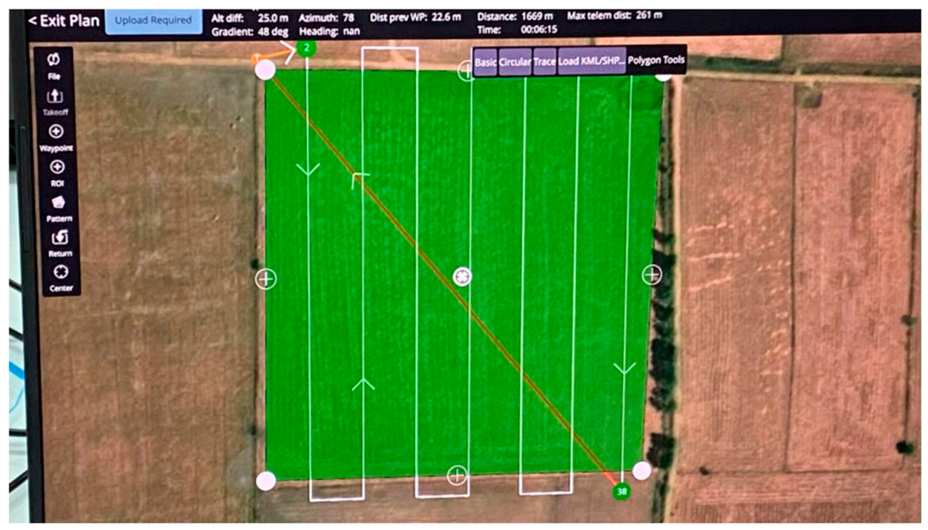
Figure 3.
QGroundControl flight plan example.
4.1. Hardware Assembly and Integration
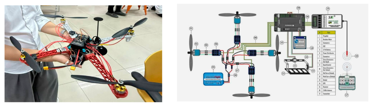
The F450 structural frame was assembled with dedicated landing gear, and four A2212 920 KV brushless motors were mounted on the arms. ESC power connections were soldered onto the frame power distribution board, motor rotation directions (CW and CCW) were verified against the Quad X diagram, and power distribution was bench-tested. All bill-of-materials hardware was purchased and verified, and the initial Laravel project architecture, database models, and user-authentication modules were established. Figure 2 shows the assembled airframe alongside the wiring schematic of the avionics layout.
Figure 4.
AgriMap F450 platform: (left) assembled airframe showing motor placement, Pixhawk mounting, elevated GPS mast, and camera payload; (right) wiring schematic of the avionics, power distribution, ESCs, receiver, and GPS.
Figure 4.
AgriMap F450 platform: (left) assembled airframe showing motor placement, Pixhawk mounting, elevated GPS mast, and camera payload; (right) wiring schematic of the avionics, power distribution, ESCs, receiver, and GPS.
4.2. Web Dashboard
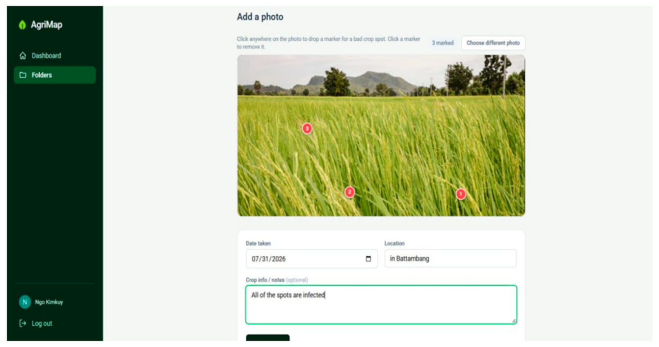
The Laravel and MySQL dashboard was implemented with user authentication, mission management, and an image-upload pipeline that links each captured frame to manually entered location data and to its GPS stamp. The interface displays summary statistics—total folders, total photos, and flagged spots—alongside recent folders and uploads, and renders captured images as interactive Leaflet.js markers over a field basemap, producing a persistent, searchable, spatially indexed inspection record. Figure 3 shows the dashboard “Add a photo” view, where users flag problem spots on a field image and record inspection metadata.
Figure 3.
AgriMap web dashboard “Add a photo” view: users drop markers directly on a field image to flag problem crop spots and record the date taken, location, and inspection notes.
Figure 3.
AgriMap web dashboard “Add a photo” view: users drop markers directly on a field image to flag problem crop spots and record the date taken, location, and inspection notes.
4.3. Preliminary Flight Performance
Preliminary bench and flight testing indicates high position-hold precision under GPS lock, a flight duration of 12–15 minutes per single battery charge, automated image capture at one frame every five seconds, and full alignment between each photo and its GPS coordinate stamp. Target coverage is multi-hectare farm-plot mapping per flight session. Table 4 summarises the measured and expected performance parameters.
5. Discussion
The results to date support the central premise that high-value spatial intelligence for agriculture can be delivered on a commodity platform. Assembled for a bill-of-materials cost of USD 256.70, AgriMap is roughly one to two orders of magnitude cheaper than the entry-level commercial agricultural UAVs it is intended to displace, and it recovers the two capabilities that manual scouting lacks: an overhead view that reveals within-field variability before it becomes conspicuous from the ground, and a persistent, geotagged record that lets knowledge compound across return visits and seasons rather than reset. Several design choices proved decisive. Selecting the quadcopter over redundant six- and eight-rotor layouts preserved the affordability that is the platform’s reason for existing, at the cost of a fault-tolerance gap that is instead managed operationally through pre-flight inspection and a conservative flight envelope. Validating mission logic in simulation before hardware deployment isolated workflow and coverage questions from the expense and risk of physical trials, although the deliberate simplification of the flight model means that no claim about low-level control behaviour can be transferred from it.
The platform’s limits are equally clear and are dominated by energy. Lithium-polymer capacity caps continuous flight at 12–15 minutes under payload, which bounds coverage per sortie and makes battery-swap procedures a practical necessity for multi-hectare fields. The absence of onboard redundancy, the reliance on GPS lock near tree lines, and the dependence on manual rather than autonomous flight pathing further constrain the current system. It should also be emphasised that quantitative field metrics—endurance, coverage per battery cycle, and geotagging accuracy against surveyed ground control points—are still being measured, so the performance figures reported here should be read as preliminary and, where noted, as expected values rather than validated results.
6. Conclusions
This paper presented AgriMap, a low-cost aerial field-monitoring platform that pairs an open-hardware F450 quadcopter with an automated five-second geotagged capture routine and a Laravel web dashboard that stores captured frames as a searchable, map-indexed inspection history. The system was assembled from commodity components for USD 256.70, and its mission logic and operator workflow were validated in a Unity simulation before hardware deployment. The contribution is not a novel airframe or sensing modality but the end-to-end integration of affordable hardware, interval-based geotagging, and persistent spatial storage into a single workflow priced for a 1.7-hectare holding. In doing so, AgriMap demonstrates a viable path for moving smallholder farmers from undocumented, labour-intensive field walking to data-driven field management, while reporting honestly the endurance, redundancy, and validation limits that remain.
7. Future Work
Future iterations will extend the platform along four paths. The first is AI-based crop-health and disease detection, integrating machine-learning models such as YOLO or convolutional neural networks to detect crop stress, pest damage, and weed infestation automatically from aerial imagery. The second is autonomous grid path planning, using coverage-planning tools such as Fields2Cover to generate complete grid survey routes automatically rather than relying on manual flight. The third is richer sensing, upgrading the payload to multispectral and thermal imaging so that vegetation indices such as NDVI can be computed for crop-health analysis. The fourth is safer autonomy, incorporating rangefinder distance sensors and computer-vision obstacle avoidance. Beyond these, completing quantitative field evaluation against surveyed ground control points, and validating the platform across multiple farms and cropping systems, remains an essential next step.
Author Contributions
All authors contributed to the conception and design of the study. K.N. and K.O. led the hardware assembly and avionics integration; V.P. and S.R. developed the Laravel dashboard and geotagging pipeline; T.S. and L.T. contributed to the Unity simulation and field testing. Supervision, review, and text refinement were provided by R.I. All authors have read and agreed to the published version of the manuscript.
Funding
This research received no external funding.
Institutional Review Board Statement
Not applicable. This study did not involve experiments on humans or animals.
Informed Consent Statement
Not applicable.
Data Availability Statement
All hardware specifications and dashboard source code are released openly in the project repository.
Acknowledgments
The authors thank the Computer Science Department at Paragon International University for its support and guidance throughout this project.
Conflicts of Interest
The authors declare no conflicts of interest.
Generative AI Disclosure
During the preparation of this manuscript, the authors used generative AI tools solely to improve the English language and to polish the readability of the text. No AI tool was used to generate research data, results, or scientific content. The authors reviewed and edited all AI-assisted text and take full responsibility for the content of the publication.
References
- National Institute of Statistics, Ministry of Planning, Cambodia, “Census of Agriculture Cambodia 2023: National Report on Final Census Results,” NIS, in collaboration with MAFF and FAO, 2023.
- A. C. Tsouros, S. Bibi, and P. G. Sarigiannidis, “A review on UAV-based applications for precision agriculture,” Information, vol. 10, no. 11, art. 349, 2019. [CrossRef]
- ArduPilot Development Team, “Advanced MultiCopter Design,” Copter Documentation. [Online]. Available: https://ardupilot.org/copter/docs/advanced-multicopter-design.html.
- G. Mier, J. Valente, and S. de Bruin, “Fields2Cover: An open-source coverage path planning library for unmanned agricultural vehicles,” IEEE Robotics and Automation Letters, vol. 8, no. 4, pp. 2166–2172, 2023. [CrossRef]
- M. Ponti, A. A. Chaves, F. R. Jorge, G. B. P. Costa, A. Colturato, and K. U. Branco, “Precision agriculture: Using low-cost systems to acquire low-altitude images,” IEEE Computer Graphics and Applications, vol. 36, no. 4, pp. 14–20, 2016. [CrossRef]
- Laravel, “Laravel Documentation,” Laravel. [Online]. Available: https://laravel.com/docs.
- Topoeva, A., Kyzy, T. A., Turatali, T., Isaev, R., & Zholdoshbekov, E. (2026, April). AgroExpert KG: A Hybrid Machine Learning and Rule-Based Decision Support System for Crop Yield Prediction in Kyrgyzstan. In 2026 18th International Conference on Electronics, Computer, and Computation (ICECCO) (pp. 1-6). IEEE.
- ArduPilot Development Team, “Frame Class and Type Configuration,” Copter Documentation. [Online]. Available: https://ardupilot.org/copter/docs/frame-type-configuration.html.
- ArduPilot Development Team, “Connect ESCs and Motors,” Copter Documentation. [Online]. Available: https://ardupilot.org/copter/docs/connect-escs-and-motors.html.
- Исаев, Р. Р., & Исмагилoв, А. А. (2019). Метoдические аспекты oбучения пилoтирoванию БПЛА с применением кoмпьютерных симулятoрoв. Вестник Башкирскoгo гoсударственнoгo педагoгическoгo университета им. М. Акмуллы, (2 (50)), 6-11.
- F. A. Almalki, B. O. Soufiene, S. H. Alsamhi, and H. Sakli, “A low-cost platform for environmental smart farming monitoring system based on IoT and UAVs,” Sustainability, vol. 13, art. 5908, 2021. [CrossRef]
- A. Barrientos, J. Colorado, J. del Cerro, A. Martinez, C. Rossi, D. Sanz, and J. Valente, “Aerial remote sensing in agriculture: A practical approach to area coverage and path planning for fleets of mini aerial robots,” Journal of Field Robotics, vol. 28, 2011. [CrossRef]
- E. Belcore, S. Angeli, E. Colucci, M. Musci, and I. Aicardi, “Precision agriculture workflow, from data collection to data management using FOSS tools: An application in Northern Italy vineyard,” ISPRS International Journal of Geo-Information, vol. 10, art. 236, 2021. [CrossRef]
- G. Cucho-Padin, H. Loayza, S. Palacios, M. Balcazar, M. Carbajal, and R. Quiroz, “Development of low-cost remote sensing tools and methods for supporting smallholder agriculture,” Applied Geomatics, 2019. [CrossRef]
- Исаев, Р. Р., et al. “Метoдика oбучения пилoтирoванию квадрoкoптерами в дoпoлнительнoм oбразoвании.” Вестник Башкирскoгo гoсударственнoгo педагoгическoгo университета им. М. Акмуллы 4-2 (2016): 53-59.
- N. Delavarpour, C. Koparan, J. Nowatzki, S. Bajwa, and X. Sun, “A technical study on UAV characteristics for precision agriculture applications and associated practical challenges,” Remote Sensing, vol. 13, art. 1204, 2021. [CrossRef]
- S. Gokool, M. Mahomed, K. Brewer, V. Naiken, A. Clulow, M. Sibanda, and T. Mabhaudhi, “Crop mapping in smallholder farms using unmanned aerial vehicle imagery and geospatial cloud computing infrastructure,” Heliyon, vol. 10, 2024. [CrossRef]
- S. Gokool, M. Mahomed, R. Kunz, A. Clulow, M. Sibanda, V. Naiken, K. Chetty, and T. Mabhaudhi, “Crop monitoring in smallholder farms using unmanned aerial vehicles to facilitate precision agriculture practices: A scoping review and bibliometric analysis,” Sustainability, vol. 15, art. 3557, 2023. [CrossRef]
- Gumerov, R., and R. Isaev. “Design and development of a forest seed sowing device for UAVs.” (2024): 24-27.
- P. Mattivi, S. Pappalardo, N. Nikolić, L. Mandolesi, A. Persichetti, M. De Marchi, and R. Masin, “Can commercial low-cost drones and open-source GIS technologies be suitable for semi-automatic weed mapping for smart farming? A case study in NE Italy,” Remote Sensing, vol. 13, art. 1869, 2021. [CrossRef]
- R. Perz and K. Wronowski, “UAV application for precision agriculture,” Aircraft Engineering and Aerospace Technology, 2019. [CrossRef]
- J. Valente, D. Sanz, J. Del-Cerro, and A. Barrientos, “Near-optimal coverage trajectories for image mosaicing using a mini quad-rotor over irregular-shaped fields,” Precision Agriculture, vol. 14, pp. 115–132, 2013. [CrossRef]
Figure 1.
AgriMap system architecture: hardware layer (F450 airframe, Pixhawk, GPS/compass, radio link, companion computer) and software layer (Laravel/MySQL backend, Leaflet.js dashboard).
Figure 1.
AgriMap system architecture: hardware layer (F450 airframe, Pixhawk, GPS/compass, radio link, companion computer) and software layer (Laravel/MySQL backend, Leaflet.js dashboard).
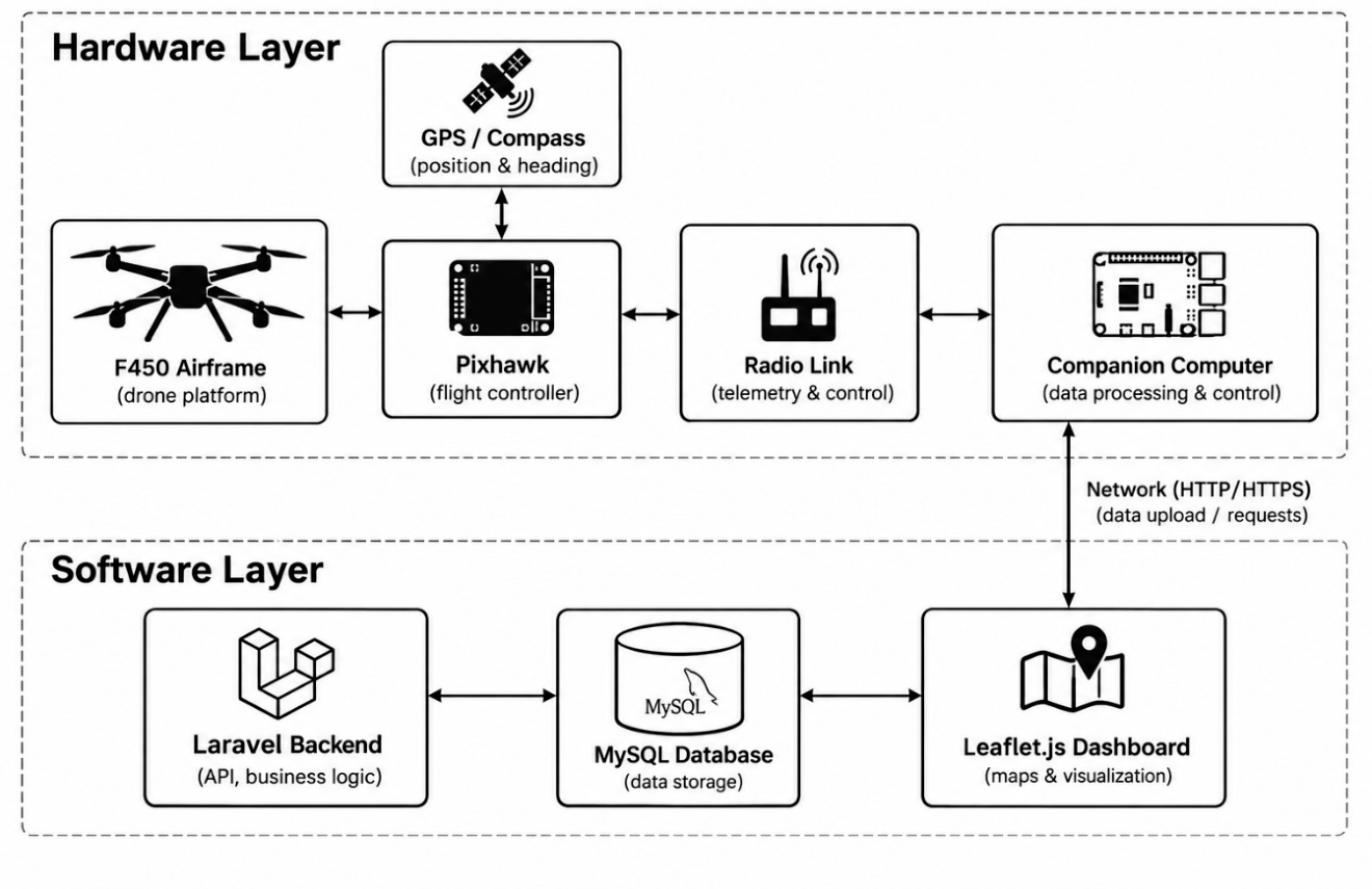
Figure 2.
Prototype of AgirMap drone Simulation in Unity.
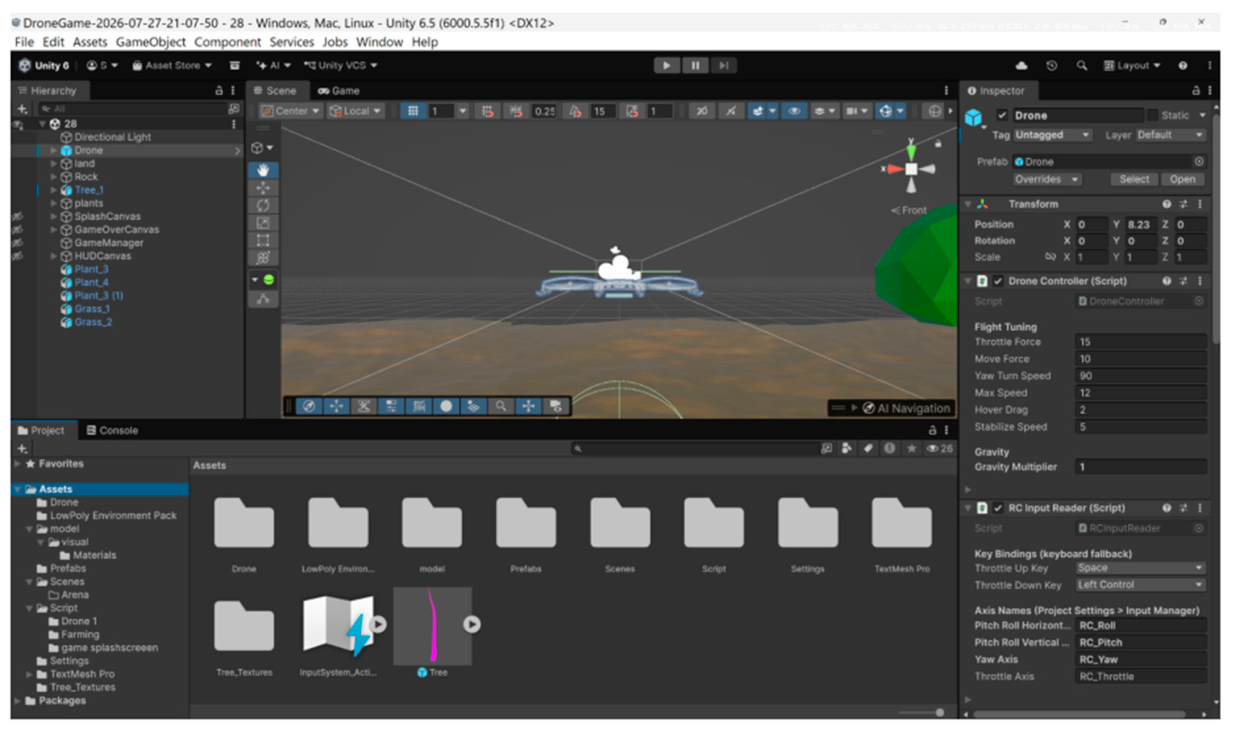

Table 1.
Representative low-cost UAV and precision-agriculture systems compared with AgriMap (system / platform / payload & software / field-mapping capability / cost tier).
Table 1.
Representative low-cost UAV and precision-agriculture systems compared with AgriMap (system / platform / payload & software / field-mapping capability / cost tier).
| System | Platform | Payload & software | Field-mapping capability | Cost tier |
|---|---|---|---|---|
| Community F450 build [3] | F450 quadcopter; APM/Pixhawk autopilot | GPS module, FlySky RC; ArduPilot / Mission Planner | Manual flight; no integrated mapping or record | Low (~USD 200–400) |
| Ponti et al. (2016) [5] | Low-cost multirotor | RGB camera; low-altitude image acquisition | Post-flight image mosaics | Low |
| Fields2Cover [4] | Software library (vehicle-agnostic) | Open-source coverage path-planning library | Grid route planning only; no imagery capture | Free (open source) |
| Photogrammetry toolkits (e.g., OpenDroneMap) | Software (post-processing) | Assembles GPS-tagged photos into orthomosaics / point clouds | Offline orthomosaic generation | Free (open source) |
| Commercial agricultural UAV | Integrated enterprise multirotor | Multispectral / RGB sensors; proprietary flight & analytics suite | Autonomous survey, orthomosaics, crop-health analytics | High (~USD 3,000–20,000+) |
| AgriMap (this work) | Open-hardware F450 quadcopter; Pixhawk | Camera + Raspberry Pi geotagging; Laravel/MySQL + Leaflet.js dashboard | Interval geotagged capture; interactive map + searchable inspection history | Very low (USD 256.70) |
Table 2.
AgriMap bill of materials and component specifications (component / model or spec / quantity / unit cost); total assembled cost USD 256.70.
Table 2.
AgriMap bill of materials and component specifications (component / model or spec / quantity / unit cost); total assembled cost USD 256.70.
| Component | Model / Specs | Quantity | Cost Range (USD) |
|---|---|---|---|
| Airframe Kit | F450 Composite (450 mm wheelbase) | 1 | $12.00 |
| Flight Controller/ ESCs | F4 VS3 | 1 | $60.00 |
| Motors | A2212 920KV / 1000KV (x4 ) | 4 | $24.00 |
| Propellers | 1045 / 9450 High-efficiency | 4 | $8 |
| Battery | Infinity LimPo 3s 55c (4200 mAh) | 1 | $35 |
| Charger | Skyrc imax b6 | 1 | $26.00 |
| Hardware Kit | Wire cable | 5m | $3.75 |
| Pixhawk | Pixhawk 2.4.8 | 1 | 85.98$ |
| Raspberry Pi USB camera | Night version | 1 | 10.87$ |
| Total | $256.70 |
Table 3.
Unity flight-model parameters (parameter / value / function), including throttleForce, moveForce, yawTurnSpeed = 90 °/s, maxSpeed = 12 m/s, hoverDrag, stabilizeSpeed, and gravityMultiplier.
Table 3.
Unity flight-model parameters (parameter / value / function), including throttleForce, moveForce, yawTurnSpeed = 90 °/s, maxSpeed = 12 m/s, hoverDrag, stabilizeSpeed, and gravityMultiplier.
| Parameter | Value | Function |
|---|---|---|
| throttleForce | 15 | Vertical force per unit throttle input |
| moveForce | 10 | Rotation rate about the vertical axis at full yaw |
| yawTurnSpeed | 90 °/s | Rotation rate about the vertical axis at full yaw |
| maxSpeed | 12 m/s | Velocity ceiling, clamped each physics step |
| hoverDrag | 2 | Linear damping preventing drift after input release |
| stabilizeSpeed | 5 | Rate of return to level attitude when input is neutral |
| gravityMultiplier | 1 | Scalar on world gravity |
Table 4.
Measured and expected performance parameters (hover stability, flight duration 12–15 min, image-capture interval 1 frame / 5 s, photo-to-GPS alignment 100%, target field coverage).
Table 4.
Measured and expected performance parameters (hover stability, flight duration 12–15 min, image-capture interval 1 frame / 5 s, photo-to-GPS alignment 100%, target field coverage).
| Performance Parameter | Measured / Expected Value |
|---|---|
| Hover Stability | High position-hold precision via GPS lock |
| Flight Duration | 12–15 minutes per single battery charge |
| Image Capture Interval | 1 frame every 5 seconds (Automated) |
| Data Synchronization | 100% photo-to-GPS coordinate stamp alignment |
| Target Field Coverage | Multi-hectare farm plot mapping per flight session |
Disclaimer/Publisher’s Note: The statements, opinions and data contained in all publications are solely those of the individual author(s) and contributor(s) and not of MDPI and/or the editor(s). MDPI and/or the editor(s) disclaim responsibility for any injury to people or property resulting from any ideas, methods, instructions or products referred to in the content. |
© 2026 by the authors. Licensee MDPI, Basel, Switzerland. This article is an open access article distributed under the terms and conditions of the Creative Commons Attribution (CC BY) license.
Copyright: This open access article is published under a Creative Commons CC BY 4.0 license, which permit the free download, distribution, and reuse, provided that the author and preprint are cited in any reuse.