

Submitted:
06 September 2026
Posted:
07 September 2026
You are already at the latest version
Abstract
This study explores the role of various environmental factors in the distribution of Paleolithic sites in France between 34 and 21 calibrated kiloanni before present. We compiled a database of occurrences of Gravettian, Solutrean and Badegoulian technocomplexes and then analysed the distribution of archaeological sites for these various cultural periods via Geographic Information System and statistical methods. These examinations took into account a number of different parameters, such as current land use, altitude, latitude, exposure, hydrology, geology and archaeological survey coverage. For all parameters considered, the analysis shows that the distribution of archaeological occurrences deviates significantly from random. Although the parameters related to climate (altitude, latitude, exposure) clearly indicate that it played an important role in settlement, the analysis also highlights positive or negative relationships between other factors and the distribution of archaeological sites, particularly locations of lithic raw material sources, sand deserts, and major rivers. These correlations can be explained either by a bias in the archaeological record or because these factors were favourable or, conversely, unfavourable to the settlement of Paleolithic groups. Ultimately, this study suggests that approaches based solely on the outputs of paleoclimatic simulations alone may not satisfactorily explain late Paleolithic settlement.
Keywords:
Paleolithic site distributions
; culture-environment relationships
; France
; last glacial maximum
; Gravettian
; Solutrean
; Badegoulian
1. Introduction
Since the pioneering work of Demars [1], the role of climate variability on the settlement of Western Europe during the late Paleolithic has been the subject of a great deal of research in recent decades (e.g., [2,3,4,5,6]). According to data on sub-actual hunter-gatherers, population density is closely linked to the mode of subsistence, which is itself strongly influenced by the environment and its productivity in terms of vegetation and animal biomass [7,8]. It follows that climate, on which the vegetal environment largely depends, would have influenced Paleolithic settlement, by modulating the quantity of available resources and the extent of the various biotopes exploited over time.
For the late Paleolithic, all studies based on the analysis of georeferenced databases of archaeological sites agree that there was a contraction of settlement into lower latitudes of Europe during the coldest periods of the Last Glacial Maximum (LGM), ca. 26–19 calibrated kiloanni before present (cal ka BP) [9]. A recolonization of northern latitudes and mountain ranges during Europe’s deglaciation followed this geographic contraction [1,10,11,12,13]. During cold periods, the most densely populated areas were Southwestern France, the southern European peninsulas and parts of Central Europe. At the same time, the frequency of sites (or dated sites) per period, considered by several authors to be an indicator of population density, decreased in Europe during cold phases, reaching a minimum during the Last Glacial Maximum [1,3,14,15,16,17]. This drop in density correlates with a genetic bottleneck in Western Europe and a genetic turnover in Southeastern Europe [18,19].
From the earliest studies [1,10], the decline in population has been interpreted as the result of a combination of lower temperatures and drier conditions. Without completely revising this view, subsequent studies have made extensive use of climate simulations and have made it possible to test the respective roles of various parameters. Modelling settlement by taking into account known relationships between climate and population density for hunter-gatherers, and incorporating evapotranspiration (ET), the hydrological budget (a proxy for ecosystem productivity), and the temperature of the coldest month (a factor influencing winter mortality), correctly reproduces the distribution of LGM sites in Europe [3]. Using new climate simulations, Burke et al. [4] indicate that the best explanatory variables for site distribution are altitude and climatic parameters, particularly spring rainfall variability, average autumn temperature, and temperature variability in autumn and winter. These factors, particularly temperature and precipitation variability, have been interpreted in terms of ecological risk that human groups faced [20], in which higher ecological risk reduced the predictability of animal and plant resources. Such factors would, thus, play an important role in population size fluctuations.
A number of studies point to the discontinuous nature of areas favourable to Paleolithic settlement in Europe during the Last Glacial. The ways in which settlement patterns were adjusted in response to the coldest periods remain a matter of debate (migration, local extinction of groups, persistence of cryptorefugia favouring rapid recolonization of northern regions during climatic improvements, changes in the cycles and routes of nomadism) [4,17,21]. Others, however, suggest that there was no fragmentation of settlement areas, allowing for an uninterrupted flow of cultural elements and genes between populations [3,22]. Eco-cultural niche modelling of the Solutrean by [23] also suggests that much of southern Europe was contained within its reconstructed niche, but these groups did not occupy it in its entirety due to the presence of another contemporary technocomplex situated in its eastern distribution (the Epigravettian).
The following assumption tends to form the basis of most, if not all, studies: the spatial distribution of known Paleolithic sites and their number provide a reliable indication of populated (or, conversely, unpopulated) areas and the density of occupation. Although known sites represent only a small fraction of the occupations that existed, it is often assumed that they provide a representative view of past settlement. Formal tests of this assumption are lacking. Some prehistorians who have empirical experience of various technocomplexes, however, argue that this premise needs to be rigorously evaluated and discussed. Intensive terrestrial surveys at a regional scale always lead to the discovery of new sites, some of which represent the first observations of a particular archaeological culture in those areas. To a certain extent, however, this assumption of representativity has been validated a posteriori at the European scale: the general pattern of populated areas across Europe has not varied significantly between the first published estimates [1,14] and those proposed subsequently [3,4,13,17,21,24,25], despite the increase in the number of known sites over the years. This situation suggests that other potentially relevant factors, such as bias linked to regional differences in knowledge or issues relating to site preservation or accessibility, do not appear to play an influential role. This hypothesis, however, warrants further research. In particular, the presence of thick loess cover in Northern France has been cited as a factor limiting the visibility and accessibility of sites, thereby explaining the low number of known occurrences in this region (e.g., [26,27]). A few sites have indeed been discovered in loess sequences several metres deep during exceptional works (e.g., [27,28]).
Although the prevailing hypothesis considers climate to be the primary factor responsible for the settlement pattern of Late Paleolithic Europe, the various studies suffer from limitations. These shortcomings are:
(1) The employed climate models have their own limitations. In particular, simulations often insufficiently reproduce temperatures derived from proxies such as pollen [29] or field evidence of permafrost [30]. The optimal conditions of temperature and precipitation for settlement scenarios proposed in some studies are, therefore, not reliable, and the boundaries of large biomes remain imprecise. However, these problems have been partially resolved in recent years with advances in modelling (e.g., [31]). Millennial scale climate variability (i.e., the Dansgaard-Oeschger events) is poorly accounted for in many simulations.
(2) Non-linear effects between climate and population density may exist, particularly in relation to vegetation cover dynamics. Tallaavaara and Seppä [32] showed that, in Scandinavia, the gradual colonisation of the forest by spruce during the first half of the Holocene led to a significant decline in population density before the arrival of agriculture, as boreal forests have lower biological productivity than deciduous forests. It remains difficult to reconstruct vegetation in detail during the Last Glacial, both from proxies (pollen, macroremains) and from simulations. However, vegetation studies converge in considering that steppe-tundra with a few patches of boreal forest in valleys remained the dominant biome throughout the Late Paleolithic in mid-latitude Europe (e.g., [33,34]). The effects related to vegetation cover dynamics were likely to have been minor and, therefore, we consider them to have been negligible.
(3) Environmental factors not directly related to climate but determined by geological heritage and relief may have played an important role in settlement. This is particularly true of sand deserts, which developed extensively during the Last Glacial in areas without relief and where abundant sources of sand (particularly coastal and glacial) were available for deflation. Bertran et al. [35] demonstrated that the cover sands that developed in Southwest France provide a convincing explanation for the distribution of sites observed at a regional level. According to these authors, the sand deposits, which have yielded few traces of Late Paleolithic settlement, were low-productivity areas unattractive to animals and their predators (including humans) and likely acted as a physical obstacle modulating exchanges between settlement areas. This could, in part, explain the geographically differentiated cultural characteristics for some technocomplexes in Southwest France [35,36,37]. Other sand deserts existed in Europe, and they too may have played a role underestimated until now.
(4) Other factors favourable to settlement are mentioned frequently in regional studies, such as the proximity of lithic raw material (flint) sources [38,39] and relief, in particular large valleys (e.g., [35,40]). Although the transport of raw materials over long distances (over 150 km) has been documented in the late Paleolithic contexts (e.g., [41,42,43,44]), the proximity of sites to known source areas is often emphasised. In northern Hungary, Trajer [39] used statistical analysis of late Paleolithic occupations to show that the average distance between sites and raw material sources is less than 10 km. In Southwest France, preventive archaeology also has noted a wealth of late Paleolithic occupations near outcrops of high-quality flint such as the Bergeracois flint and conversely, the scarcity of occurrences on tertiary molasse substrate lacking flint. The influence of these factors on the distribution of sites at a larger scale seems likely and warrants further investigation.
5) While sociocultural dynamics and group organization were influenced to varying extents by climate variability [45,46,47], cultural choices and cultural evolution clearly played key roles in such dynamics. Consequently, spatial distributions and site frequency may have fluctuated due to seasonal activity cycles, mobility pattern, and group size (e.g., [48,49,50]). It is difficult to know, however, the extent to which such factors influenced occurrence distributions and whether such influences were consistent through time.
This study aims to analyse in detail the influence of various environmental factors sensu lato (geographical coordinates, topography, geomorphology, geology, current land use) on the distribution of Paleolithic sites, using an approach similar to that proposed by [51]. The period under consideration, 34–21 ka includes some of the coldest episodes of the Last Glacial, the GS-6 to GS-2.1a stadials, as well as more temperate interstadial intervals, GI-6 to GI-2 [52]. This chronological interval includes the Gravettian technocomplex, the development of the Solutrean, and the emergence of the Badegoulian.
The geographical scope of the study is restricted to present-day France in order to limit the time spent on a critical analysis occurrence contexts and lithic assemblage attributes. We compiled a database based on recent studies [36,50,53,54,55,56], as well as new data from preventive archaeology work. In practice, references were screened for precise information (such as descriptions and illustrations) that would allow for reliable cultural attributions: fossiles directeurs, technical markers and diagnostic chaînes opératoires, evaluations of assemblages’ archaeological or stratigraphic contexts. The various layers of information, which include data on site location and paleoenvironmental data, were cross-referenced using a Geographic Information System (GIS). The compiled data were analysed statistically to identify robust associations. Finally, we assessed and interpreted the relative influence of the various factors in order to propose hypotheses concerning observed archaeological distributions.
2. Methods
2.1. Database of Occurrences
In this study, Paleolithic technocomplexes are used as basic, temporally specific cultural entities for which variations in site distributions through time are examined. The term “technocomplex” describes a practical classification of industries defined by prehistorians and based on typological and technological similarities between assemblages [57]. Because archaeological technocomplexes are defined by the presence of discrete, temporally-diagnostic artefact types, they can be reliable means of attributing archaeological assemblages, both dated and undated, to specific past “cultural” entities. 14C-dated ornamented caves that have yielded either undiagnostic or no archaeological assemblages allowing for an attribution to a specific technocomplex to be made were excluded from the inventory.
Recent Bayesian statistical analyses of available radiometric ages, reliant on both strict archaeological associations between technocomplexes and archaeological contexts (i.e., stratigraphic constraints [37,58]), have made it possible to accurately place these technocomplexes chronologically and in turn correlate them to recorded climate variability. Based on currently available data, we consider that across our region of study, all occupations belonging to a given technocomplex are approximately contemporary and fall within the intervals established by [37]. In other words, we consider negligible any delay linked to the gradual expansion or contraction of a technocomplex across the territory due to the chronological resolution that characterizes our period of study.
The database used in this study is a relational database that combines different tables associated with geographical data and cultural attributions, radiometric ages, and raw material and technological data. From this relational database, we extracted the data presented in Table 1. In this table, each row corresponds to an archaeological occurrence. Each occurrence corresponds to one or multiple, superimposed archaeological levels. In the absence of refitting tests between layers at many sites excavated in the past, it is impossible to determine whether the levels distinguished in the field are behaviourally relevant and accurately reflect distinct occupations, a single occupation whose objects have been dispersed by taphonomic processes, or a palimpsest of multiple occupations (e.g., [59,60]). The occurrences selected are for which we could make a reliable attribution to one of the technocomplexes concerned by a study period based on lithic typology or technology. A total of 440 occurrences are retained (Table 1).
Despite critical scrutiny of the available data, our approach has potential biases and limitations that should be kept in mind:
- It is impossible to directly verify each occurrence and its associated assemblages. We, therefore, relied largely on published sources and grey literature reports, which can be variable in the details provided.
- Excavation, post-excavation and curation methodological biases, especially across the 19th and 20th centuries, may have obliterated certain diagnostic features necessary for making a reliable attribution to a technocomplex (e.g., [56]).
- The definition of technocomplexes has evolved over time (particularly with regard to different analytical approaches) and research efforts dedicated to defining and examining technocomplexes are unequal.
- Finally, the varying “detectability” of technocomplexes, either bibliographic in nature or due to difficulty in identification, may have influenced our dataset, as some technocomplexes present marked and easily recognizable diagnostic artefact types, whereas others possess characteristic artefacts that are present in other technocomplexes as well, making them harder to recognize (e.g., Late Gravettian, Badegoulian without “raclettes”).
For the purposes of analysis, the technocomplexes were grouped together to divide occupations into periods of roughly comparable duration and thus obtain statistically meaningful sample sizes. These groupings are as follows: Early and Late Badegoulian (= Badegoulian), Middle and Upper Solutrean (= Late Solutrean), Protosolutrean and Lower Solutrean (= Early Solutrean), and Recent and Upper Gravettian (= Late Gravettian). The duration of these periods, which correspond to the 95% confidence intervals calculated by [37], is 2,300 years (Badegoulian), 1,604 years (Late Solutrean), 2,271 years (Early Solutrean), 1,304 years (Final Gravettian), 2,495 years (Late Gravettian), and 2,900 years (Middle Gravettian). The Lower Gravettian has not been the subject of chronological examinations comparable to those carried out on other technocomplexes, therefore, its duration remains imprecise.
2.2. Preventive Archaeology Database (Caviar)
To evaluate whether uneven survey coverage produced a biased distribution of known sites in France, we consulted the Institut National de Recherches Archéologiques Préventives’ (Inrap) Caviar database. It lists areas surveyed and provides information on the extent of the surfaces investigated (trenches) and the number of stratigraphic units (SU) containing Paleolithic remains. This database is not homogeneous across the entire territory, as some regions have been investigated more intensively and data records began being maintained later in some regions than others. Nevertheless, it provides a picture of discoveries made through “blind” survey and, given that the methods used for data collection and analysis are consistent throughout the country, does not show any major bias in favour of any particular region. Due to the nature of preventive archaeology, areas close to large urban centres and transport routes are better surveyed than more remote areas. However, the most thoroughly studied areas are spread across all regions of the study area.
Using this database (last accessed in November 2024), the ratio between the number of stratigraphic units yielding Paleolithic artefacts and exposed surface area was calculated. Calculations were carried out according to the major administrative regions (ARA: Auvergne-Rhône-Alpes, BFC: Bourgogne-Franche Comté, CIF: Centre-Ile de France, GE: Grand Est, GO: Grand Ouest, HdF: Hauts de France, NAOM: Nouvelle Aquitaine, MM: Midi-Méditerranée). As late Paleolithic discoveries remain few in number, the entire Paleolithic period was included in the analysis.
2.3. Environmental Information Layers
Various layers of environmental information (topography, geomorphology, geology, current land use) were included and processed using QGIS software version 3.40.6. For the relief data, we used the European Digital Elevation Model (EU-DEM) with a horizontal resolution of 30 m (https://land.copernicus.eu/imagery-in-situ/eu-dem/eu-dem-v1). Rivers come from the shapefile provided by the Institut Géographique National (https://www.ign.fr/carto). We considered only rivers with a channel width greater than 15 m, as they are associated with large valleys.
For aeolian deposits, we employed two classes of data. The distribution of sand and loess proposed by [61], derived from a map of the topsoil texture produced as part of the European LUCAS project [62], takes into account all aeolian deposits, even those of low thickness. The distribution of loess proposed by [63], extracted from the 1:50,000 geological map of France, is complementary and only depicts areas where deposits exceed approximately 2 m in thickness and constitute extensive cartographic units.
We obtained the distribution of raw material sources (flint and related knappable stone) from the mapping efforts provided by a consortium of researchers, which is available as a shapefile at https://www.cartosilex.fr/ (last accessed November 2024). Since only a portion of France is covered, we produced a new map for the entire territory by extracting geological formations that contain flint in a primary position (mainly limestone) from the 1:1,000,000 geological map of France (https://infoterre.brgm.fr/) and verified the consistency between the two maps in areas where they overlapped. Due to contrasting resolution and the grouping of geological strata, the new map is less accurate and overestimates the extent of source areas. We also took into account formations containing flint in a secondary position, particularly weathering products of limestone. Only alluvial formations associated with rivers that cross primary or secondary flint sources over a significant portion of their course were included. We removed areas with thick loess cover [63] from the broad areas of weathering clay on chalk depicted on the 1:1,000,000 map in the northern half of France.
For climatic factors, we chose various indirect indicators: (1) altitude and latitude measured using the EU-DEM, (2) exposure (considered significant when the slope exceeds 5°), also measured using the EU-DEM, and (3) the extent of permafrost during the LGM. Due to the punctual nature of the permafrost indices recorded in the field [30] and the difficulty in precisely delimiting its extent, we used the output of a simulation carried out using the Max Planck Institute’s Global Climate Model ([31]; updated in [64]). The results show good agreement with field evidence and we, therefore, considered them robust. Permafrost indicates areas with null or negative average ground temperatures during the LGM. This distribution may have changed throughout the period under consideration (34–21 cal ka BP), particularly during long interstadials, but it is not possible to identify specific variations due to permafrost traces’ general lack of precise chronological data.
We derived the current land use type (in 2012) in France from the European Environment Agency’s CORINE Land Cover (CLC) map(https://www.statistiques.developpement-durable.gouv.fr/corine-land-cover-0), which classifies land into different categories (urban areas, agriculture, forest, etc.) based on satellite imagery. We used these data to identify the contexts in which recorded sites are currently situated.
2.4. Statistical Analyses
For the statistical analysis, we assumed that each occurrence of a technocomplex at a site was independent of previous occurrences at the same site. Thus, a site can be counted several times when if it contains multiple levels representing different technocomplexes. In such situations, we consider that the different occupations were sufficiently distant in time such that the choice of play by human groups of a given technocomplex did not play a role in the subsequent occupation of the site by human groups of a different technocomplex.
Our statistical assessments evaluated whether observed distributions deviated from random. To do so, we first defined the “credible” settlement area to be the portion of the landscape with an elevation below 600 m (see below). Next, we defined n to be the number of sites in the database. We repeated (B = 200) a procedure of randomly placing n locations (points) within the credible settlement area. We, thus, generated B distributions for the variable of interest (e.g., distance to the closest river, latitude, elevation…). We then compared these B random distributions to the observed distribution of archaeological occurrences (i.e., sites). We plotted the empirical cumulative distribution function of each of these distributions, along with the 95% confidence region of the observed distribution [65]. This allowed us to evaluate whether observed settlement patterns significantly deviated from random.
We applied a similar protocol for examinations of aeolian deposits and their relationship to archaeological occurrences when conducting a correspondence analysis that included distributions of the different types of aeolian deposits (observed distribution and B random distributions) as inputs. Observing the position of the actual distribution relative to the 95% confidence ellipse of the B artificial distributions allowed us to determine whether the association between occurrences and aeolian deposits significantly deviated from random expectations.
We employed R 4.6.0 [66] for all statistical analyses. The R codes produced for this study, along with the list of employed R packages, additional results and detailed elements of interpretation, are available on Software Heritage (https://archive.softwareheritage.org/swh:1:dir:bdb7416341238d5e0b372bc7287861a090d500f9).
3. Results
3.1. Distribution of Occurrences Listed in the Database
Overall, occurrences (all technocomplexes considered) are distributed unevenly across the territory (Figure 1) and show a concentration in Southwest France that extends into adjacent areas of the Iberian Peninsula (Cantabria, not documented here), as has already been noted in previous studies [1,4,13]. Areas of lower site density also appear around the Mediterranean Sea and, to a lesser extent, in the Paris Basin, while scattered occurrences are present in Northeast France and neighbouring regions (Belgium, Germany). For the broad technocomplex groups (see above), two types of distributions are apparent in the maps and the graph showing mean latitude as a function of longitude for each technocomplex (Figure 2). The first pertains to the Lower and Late Gravettian, during which a large part of the territory and neighbouring regions in the northeast were occupied. The other corresponds to the other technocomplexes, whose settlement contracted southwards, with only one observed site in the HdF and GE regions, i.e., of the northern and northeastern portions of the study area. The Late Gravettian has the highest average latitude of all the considered technocomplexes.
The frequency of occurrences by our technocomplex groupings exhibits significant variability, with a minimum during the Early Solutrean and Final Gravettian (Figure 3A). When weighting the number of occurrences by the duration of each technocomplex (taken from [37]), this significant variability through time remains. The pattern that emerges is that the number of occurrences per 1,000 years for technocomplexes that include an interstadial is significantly higher than those that were present only during a stadial (Figure 3B). The Late Gravettian, which spans a period including the GI-3 interstadial and possibly GI-4 (two brief periods of climate improvement following the extremely cold GS-5 stadial), stands in an intermediate position. This indicates that warmer periods are characterized by a higher frequency of archaeological sites. This is consistent with field observations in the loess deposits of Northern France where the relatively rare archaeological occurrences are associated with paleosols, which formed during interstadial events (e.g., the site of Renancourt [67]).
3.2. Caviar Database
The analysis of the Caviar database highlights the following points:
(1) Open surfaces (trench areas) vary greatly in extent by region (Figure 4A). They exceed at least 1.2 km² (HdF) and reach up to 17.0 km² (GE). This variability is due to the variable inclusion of such data, as many older operations are not included in the database.
(2) The ratio between the number of stratigraphic units containing Paleolithic remains (all periods combined) and investigated surface area (in km²) varies considerably by region (Figure 4B) and ranges from 0.833 (HdF) to 60.982 (MM). In general, the ratio decreases with latitude. The regions that have yielded the most remains are MM, NAOM, and ARA, i.e., the southern half of France. Conversely, the region that yielded the least is HdF, which is also the northernmost. The very high value for the MM region is likely an artefact of the criteria used to define and record stratigraphic units, especially when compared to NAOM. In the MM study area, some operations defined a stratigraphic unit on the basis of at least one observed Paleolithic artefact. Conversely, in the NAOM study area, stratigraphic units were created only when a large number of artefacts were observed, with smaller numbers or individual finds considered to represent “background noise”.
The picture that emerges from this analysis is that the distribution of Paleolithic sites found during large-scale archaeological surveys is not homogeneous, but rather concentrated in the southern regions of the study area. This distribution of archaeological occurrences from the Inrap database is similar to that visible in our database.
3.3. Distribution of Occurrences According to Land Use Type
A comparison of our database with the current land cover (CLC) shows that occurrences are mainly found in cultivated areas (45.6%), closely followed by forested areas (43.8%) and, to a minor extent in artificial areas (9.8%), particularly peri-urban areas (discontinuous urban fabric) (Figure 5). When these types of zones are weighted according to their relative surface area in France (< 600 m), discoveries are overrepresented in peri-urban areas, vineyards, and deciduous and mixed forests, while underrepresented in cultivated areas and, even more so, in pastures. Mineral extraction sites (quarries) are also overrepresented, but their overall importance remains minimal.
The distribution of site types (caves and rockshelters versus open air) indicates that 55.1% of the former are located in forested areas, while the latter are primarily observed in cultivated areas (including vineyards) and, more rarely, in forests (24.7%).
3.4. Distribution of Occurrences and Climate-Related Variables
The analysis of the distribution of occurrences according to altitude shows an overrepresentation of sites between 60 and 180 m, with a peak between 80 and 140 m (Figure 6A). A single site (Le Rond-du-Barry, Badegoulian, 768 m) has an altitude above 600 m, which empirically represents a “limit of habitability” with respect to sustained occupation. The comparison between the observed distribution and that of 200 random distributions of the same number of points in areas below 600 m indicates that the observed distribution deviates significantly from random (Figure 6B). None of the 200 random distributions falls within the confidence interval of the observed site distribution.
The analysis of the distribution of occurrences according to latitude also reveals a concentration between 43 and 46°N, and especially between 44 and 45°N (Figure 7A). The pattern, like with altitude, differs significantly from random expectations (Figure 7B).
Since local climate correlates strongly with altitude and latitude, it is probable that the factors behind these patterns are climatic in nature. Figure 8 shows the relationship between latitude and altitude of occurrences. As expected if climate played an important role, the maximum altitude of occurrences decreases as latitude increases. The distribution of occurrences based on site type (open air, rockshelter, cave) according to latitude and altitude does not reveal any clear trend, except for the fact that many cave sites are located between latitudes 43°N and 45°N, i.e., in the limestone-dominated landscapes of Southwestern France. Rockshelters and cave sites are more rare above 47°N, due to the reduced extent of karstic limestone formations in which they naturally occur. For all regions, rockshelters and cave sites are not the highest with respect to altitude.
We also tested the potential influence of site exposure using data from the EU-DEM. Orientations were grouped into classes of 20°. When only sites with a slope greater than 5° are considered, south-southwest orientations between 160°N and 260°N are predominant, with a peak at 180°N (southerly exposure) (Figure 9). In the northern hemisphere, such an orientation ensures a maximum exposure to solar energy at midday.
Figure 10 illustrates the distribution of occurrences, classified by technocomplexes, with the limits of permafrost during the LGM. These limits are based on simulations and field data and taken from [64]. Overall, permafrost does not appear to have limited land occupation, consistent with previous observations (e.g., [13]). However, if we consider the technocomplexes individually, it appears that the geographic extensions of the Middle Gravettian, Final Gravettian, Solutrean, and Badegoulian are limited to the northeast by the boundary of the continuous permafrost zone (i.e., by an air temperature of -3 to -5 °C). We do not observe this boundary for the Lower and Late Gravettian, for which sites exist in Northern France and neighbouring countries in the continuous permafrost zone, particularly in Belgium and Germany.
3.5. Comparison with Geological and Geomorphological Data
Overall, considering all periods together, very few occurrences are located in areas of aeolian deposits as mapped by [61] (Figure 11). Since the deposits cover only a small portion of France, the observed distribution must be compared to what it would be if the sites were randomly distributed across the territory, at least in the area identified as favourable for Paleolithic settlement, i.e., at elevations below 600 m (Figure 12A, B). This distribution depends on the proportion of surface area occupied by the different types of aeolian deposits. A comparison of the two bar plots clearly shows that occurrences in sand and loess are underrepresented. To evaluate whether this pattern deviates from random, we produced 200 random samples of the same number of points in France and evaluated the locations of the points in each sample with respect to aeolian deposits. We performed a correspondence factor analysis based on the results of these evaluations (Figure 13). It highlights the opposition between the distribution of occurrences and that of aeolian deposits. In other words, the former deviates from random expectations and reflects an inverse relationship between archaeological occurrence and aeolian deposits. The loess map proposed by BRGM [63] only covers areas with thick loess (> 2 m) and is therefore more limited in extent than in the previous map. Thick loess is mainly found in the northern third of France. The analysis produces a result consistent with that of our correspondence factor analysis (Figure 12C, D), that is an inverse relationship between loess and archaeological occurrences.
Regional studies often highlight the proximity of occupations to large rivers. To test this potential association, we calculated the distance to the nearest watercourse (wider than 15 m) for each occurrence. The result (Figure 14) shows that (1) the majority of occurrences (57%) are located less than 2 km from a river; (2) their number decreases rapidly with distance from the river; (3) the distribution of 200 random samples of the same number of points differs significantly from this pattern. For the randomization experiment, on average, only 19% are less than 2 km from a river, and the proportion of remaining sites decreases only slightly with distance. Proximity to large waterways is, therefore, a parameter that influences site distribution.
The analysis of occurrence location in relation to raw material source areas indicates that approximately 66% of them are located on flint (or related rocks) formations, while random points fall on average on such formations only approximately 41% of the time (Figure 15). When sites are surrounded with a 10 km buffer, it is apparent that almost all occurrences (97%) are located on or adjacent to flint formations. This proportion rises to over 99% when a 30 km radius buffer zone is employed. A radius of 30 km corresponds to the distance that covered in one day when walking over relatively flat terrain. Examination of the map (Figure 16) shows that the areas where occurrences are least numerous, or absent, correspond to areas where the Hercynian plutonic and metamorphic basement outcrops (Brittany, Massif Central, Vosges Mountains), but also to a portion of the Pyrenean foothills consisting of Cenozoic sandy and clayey detrital formations (molasse). This map also shows that the association between occurrences and flint-containing formations, mainly carbonate rocks, is not directly linked to the presence of karstic cavities. While areas in Southwestern France where formations that contain flint outcrops are associated with high frequencies of occurrences situated in caves and rockshelters, this is not the case in the Paris Basin and northern France, where open-air occurrences predominate. Based on the fact that this relationship holds true regardless of site type (cave, rockshelter, open-air), indicates that a clear relationship between raw material sources and sites exists.
4. Discussion
4.1. Interpretation of the Various Factors Explaining the Distribution of Occurrences
The relationship between current land cover and occurrences clearly indicates that certain environments are more favourable than others for the discovery of Paleolithic sites, particularly peri-urban areas, vineyards, forests, and, to a lesser extent, quarries. This finding largely concurs with that already made by [51] in Europe. Peri-urban areas and quarries are regularly subject to archaeological surveys, particularly in the context of preventive archaeology, and are characterized by abundant discoveries. The overrepresentation of finds in vineyards reflects the fact that the ground between the rows remains bare throughout the year, which is favourable for archaeological survey (at least until farming practices changed in recent decades to favour the development of grass cover). Conversely, occurrences are underrepresented in cultivated areas, where the length of the period without vegetation is reduced, and even more so in pastures. The abundance of discoveries in forested areas is more counterintuitive. The reason is that caves and rockshelters are mostly located in areas that are not suitable for agriculture (rock walls, scree) and, therefore, dominated by natural forest vegetation. While this variability in discoveries based on land use does represent a bias in the archaeological record [51], its overall impact on the representativeness of the database of occurrences is likely to be insignificant, mainly because the areas of under-representation or, conversely, over-representation of sites are distributed across the study area. Preventive archaeology, which has developed extensively in France since the 1990s, has sampled across the entire study area and has, thus, mitigated biases generated previously.
The analysis also shows that other variables contribute significantly to explaining the distribution of occurrences during the period 34–21 cal ka BP, including indirect climate proxies, as well as environmental parameters not directly related to climate. All variables that strongly influence local climate, such as altitude, latitude, and exposure, reveal a consistent pattern characterized by a marked decrease in occupation with latitude and altitude, with a potential continuous habitability limit of around 600 m, and orientations favourable to maximum sunlight. This finding is consistent with observations made previously [1,3,4,13,51].
Overall, low temperatures limit occupation. The ratio of occurrences per thousand years shows a sharp decrease during the GS-3 stadial, one of the coldest phases of the Last Glacial. This phase coincides with the transition between the Gravettian and the Early Solutrean. It is worth noting that it coincides with the genetic bottleneck identified in Western Europe by [18,19], thus suggesting a sharp decline in population. In turn, this suggests that, among all the factors likely to influence the number of occurrences per period (population density, seasonal activity cycles, mobility patterns, group size), population density is likely the most influential.
The southern limit of continuous permafrost, indicating a mean annual air temperature of ca. -3 to -5 °C, effectively delimits the northeastward extension of the Middle Gravettian, Final Gravettian and subsequent technocomplexes, whereas the Early and Late Gravettian are not affected by this limit and have a wider distribution. We propose two possibilities for this contrasting pattern. The first is that Early and Late Gravettian occupations in the northeast portion of our study area are largely contemporary with interstadials (relatively milder conditions). Stratigraphic distributions of Paleolithic levels in Northern France, Belgium and Central Europe support this (e.g., [68,69,70]). Furthermore, numerous researchers propose a hiatus in the occupation of Northern and Central Europe during portions of the LGM [11,12,71,72]. The second possibility is that the Solutrean and Badegoulian correspond to Western European technocomplexes present in a relatively less rigourous oceanic climate, while another technocomplex, the Epigravettian, occupied Central Europe under cold, continental conditions. This probably reflects a different culture-environment relationship between the North-Central European Epigravettian and the Solutrean-Badegoulian.
Among the environmental parameters unrelated to climate, proximity to sources of lithic raw materials appears to be a determining factor. This finding is surprising at first glance, given that the transport of raw material blocks, cores, or tool blanks over distances ranging from one to several hundred kilometres has been documented at numerous sites (e.g., [40,73,74,75,76]). The displacement of lithic raw materials, as well as ornaments [77], connected distant regions and involved movement across areas that have yielded no evidence of occupation. Aubry et al. [76] make a similar observation in Portugal and Western France. First, site visibility depends on the quantity and representativeness of the material culture remains present, which is influenced by both mobility and site function. In a given region, sites resulting from brief occupations associated with specific activities coexisted with sites where occupations were longer and activities more diverse. The latter are probably overrepresented in the database because they are more easily identifiable during archaeological surveys. The lack of such sites across large areas, however, raises questions. To explain this pattern, one hypothesis is that settlements located far from sources of raw materials are less visible in the archaeological record. Raw materials were used at sites close to sources without concern for economy. Large quantities of waste material were discarded during occupation, making them easy to detect during surveys. Conversely, raw materials transported over long distances were often curated, i.e., resharpened and reused rather than being discarded [78,79]. Sites dominated more by curation behaviours are less visible and may contain few diagnostic elements, making them difficult to attribute to a particular archaeological culture. A number of occurrences attributed to undetermined late Paleolithic technocomplex exist in the study area and have not been included in the database. According to this assumption, the distance to raw material sources would not constitute a limitation to settlement; rather, the absence of occupations more likely reflects a bias in the archaeological record related to their visibility.
The proximity of a large river is also a predictor of site distribution. There may be multiple reasons for this, including (1) access to drinking water, although a small river or springs would suffice. Therefore, this explanation is unlikely; (2) greater plant biomass in valleys compared to plateaus. Available few pollen analyses and vegetation simulations suggest the persistence of patches of shrub vegetation in valleys during the LGM (e.g., [33,80]). This would have increased available resources; (3) at least seasonally abundant animal biomass, with large valleys serving as migration corridors for large herbivores; and finally, (4) the presence of karstic cavities (rockshelters, caves) conducive to the establishment of sheltered camps along valleys in limestone terrains, particularly in Southern France. These different factors are not mutually exclusive, but together likely created conditions favourable to the occupation of large valleys.
The analysis also highlights a negative association between aeolian deposits and sites. The reasons for this may be different for areas dominated by sand and loess. For sand deposits, which are mainly located in Southwest France (“Sable des Landes”) where they cover an area of approximately 13,000 km², the hypothesis of a desert environment poor in plant and animal resources and, therefore, little used by hunter-gatherers [35] remains valid. Outcrops of cretaceous flint-bearing limestone exist in a small valley (the Ciron valley) that crosses this sand region (Villagrains flint: [81,82]). These flint sources were exploited during the Middle Paleolithic and the Late Magdalenian periods [83,84], but no LGM occupations are known in the vicinity. The aeolian sands of Sologne situated south of Orléans (Paris Basin), albeit a much smaller area (approximately 2,600 km²), provide a similar picture, with no occurrences recorded in this area.
On the other hand, with respect to loess deposits, which are present mainly in Northern France (Northern European Loess Belt, NELB) and deposited in a steppe-tundra environment capable of supporting large herbivore populations, another explanation seems plausible. Preventive archaeology data show that few Paleolithic sites have been discovered in this broad area, mainly from the Grand-Ouest (GO) and Hauts-de-France (HdF) administrative regions. Similarly, there are few sites in the Grand Est (GE) region, where loess cover is virtually non-existent. This suggests that there is no causal relationship between the presence of loess and the absence of sites. The hypothesis that a thick layer of loess limits the detection of sites during archaeological surveys alone does not explain the observed pattern. The scarcity of sites in the NELB is likely due to other factors, particularly climate, as indicated above. In contrast, it is worth noting that there are numerous occurrences in the loess band situated around the “Sable des Landes” in Southwest France (i.e., at lower latitudes in relatively close proximity to the Atlantic Ocean and thus milder climatic conditions), and this for the entire late Paleolithic [35].
4.2. Implications
The results of this study have several implications. We can reject, with a reasonable degree of confidence, the hypothesis of a significant bias in the distribution of sites linked to regional differences in archaeological survey and discovery. In particular, discoveries made over the last 30 years in the context of preventive archaeology have only marginally altered the distributions of sites described in early studies [1,13]. Southern France consistently appears to be the region with the highest concentration of Paleolithic sites.
We can also reject the hypothesis of an important bias due to issues of site visibility or discovery, particularly in areas with a thick loess cover. Although the analysis reveals a negative association between loess and occurrences, we can establish no causal link between the two, as one can observe areas of low occupation density in Northern France both within and outside the NELB. Conversely, the loess areas of the Aquitaine region in Southwestern France have high numbers of archaeological occurrences like other regions of loess in Central Europe.
Nevertheless, one cannot state that the distribution of known sites is free of any bias and thus provides a complete picture of past settlement. The highly significant relationship between the distribution of areas yielding raw materials suitable for knapping and the distribution of occurrences strongly suggests that the latter’s visibility during surveys plays an influential role. Thus, it is likely that large “void” areas on the map do not reflect a total absence of settlement, but are likely a testament of our ability to recognize or characterize occurrences with few lithic artifacts. This is because the frequency of flint artefacts in an assemblage and distance from lithic source areas are inversely related [85]. This hypothesis contradicts the idea of fragmentation of settlement areas during the coldest periods of the Last Glacial.
Analysing Paleolithic settlement in France using climate as the sole explanatory factor seems reductive, even though climate had a significant impact. Other locally and regionally expressed environmental factors, such as sandy deserts and large valleys, had significant influences that impacted broader geographic patterns to varying degrees. Climate simulations potentially offer an incomplete means of evaluating human settlement during the Pleistocene and, therefore, should be complemented with other data so that a broader range of relevant factors are considered when evaluating past settlement dynamics.
Since present-day France represents only a small portion of the European continent, it is pertinent to ask whether the importance of the parameters we identified remain relevant at this broader geographic scale. Examinations of available maps provide some means of assessing this question. Figure 17 illustrates the distribution of European Gravettian-age sites (those from this study along with those compiled by [17]) superimposed on a map of aeolian deposits [61]. The map highlights the role as a barrier to settlement played by the northern European Sand Belt (ESB). With the exception of one site in Poland, no occupations are recorded in the ESB, whereas sites are known to exist in the United Kingdom at higher latitudes. Boemke et al. [51] made a similar observation. As in Southwest France [35], they also showed that Late Magdalenian and Epipaleolithic occurrences, which are contemporary with the Lateglacial recolonization of these sands by vegetation, are, conversely, well represented.
Since limestone is the main flint-bearing formation, the geological map of Europe at a scale of 1:5,000,000 (IGME 5000) [86] provides a general, albeit approximate, overview of the distribution of raw material areas. Comparison with the distribution of LGM occupations highlights their preferential location on or near limestone outcrops (Figure 18). This pattern is particularly clear in the Iberian and Italian Peninsulas, as well as in Eastern Europe, as already noted by [39]. Boemke et al. [51] also identified an overrepresentation of sites on Jurassic and Cretaceous limestone and favoured the hypothesis that the choice of site location was tied to the presence of karstic cavities. With respect to the French Late Paleolithic record, our results allow us to reject this hypothesis (see above).
5. Conclusion
The analysis of occurrences belonging to the Gravettian, Solutrean, and Badegoulian technocomplexes in France, via GIS data and statistical methods, provide a means of exploring the possible role of numerous environmental factors in the observed distribution of Paleolithic sites between 34 and 21 cal ka BP. Our results indicate that occurrence distributions deviate significantly from random expectations. Climate, inferred here from indirect proxies (latitude, altitude, exposure), influenced observed site distributions and, particularly, explains the north-south gradient in site frequency, with southern France consistently being the region with the highest concentration of Paleolithic sites. The lowest frequency of sites corresponds to GS-3 (ca. 27–24 cal ka BP), one of the coldest events of the Last Glacial. The analysis also highlights positive or negative associations between raw material sources, major rivers, aeolian deposits and the site distribution. These correlations can be explained either by a bias in the archaeological record, due to the difficulty of identifying and characterizing occurrences poor in lithic material located far from raw material sources, or by these factors being favourable or, conversely, unfavourable to the settlement of particular areas by Paleolithic groups. Assessing the relative role of individual factors is not a trivial undertaking, and future work will necessitate the development of appropriate statistical approaches. Ultimately, this study suggests that approaches based solely on paleoclimatic simulations do not provide a complete understanding of Late Paleolithic settlement patterns. We propose that future studies should take into account additional data, particularly geological and geomorphological in nature, when examining settlement dynamics.
Author Contributions
Conceptualization, P.B. and W.B.; Formal analysis and data curation, P.B., S.A. F.S. and W.B.; Writing – original draft preparation, P.B. and F.S.; Writing – review and editing, P.B., S.A., W.B.; Funding Acquisition, P.B. and W.B.:.
Data availability statement
The R codes produced for this study, along with the list of employed R packages, additional results and detailed elements of interpretation, are available on Software Heritage (https://archive.softwareheritage.org/swh:1:dir:bdb7416341238d5e0b372bc7287861a090d500f9).
Acknowledgments
This study received financial support from the French government in the framework of the University of Bordeaux’s IdEx “Investments for the Future” program / GPR “Human Past”. The database contains data collected principally from the work of S. Ducasse, L. Klaric, C. Renard, and A. Vignoles, and we thank them sincerely for their input during its construction. We are grateful to the other people who also contributed to the database, particularly N. Connet, L. Deschodt, O. Franc, G. Jamet, and A. Morala.
Conflicts of interest
The authors declare no conflicts of interest.
References
- Demars, P.-Y. Démographie et occupation de l’espace au Paléolithique supérieur et au Mésolithique en France. Préhistoire Eur. 1996, 8, 3–26. [Google Scholar]
- Wygal, B.T.; Heidenreich, S.M. Deglaciation and human colonization of Northern Europe. J. World Prehistory 2014, 27, 111–144. [Google Scholar] [CrossRef]
- Tallavaara, M.; Luoto, M.; Korhonen, N.; Järvinen, H.; Seppä, H. Human population dynamics in Europe over the Last Glacial Maximum. PNAS 2015, 112(27), 8232–8237. [Google Scholar] [CrossRef]
- Burke, A.; Kageyama, M.; Latombe, G.; Fasel, M.; Vrac, M.; Ramstein, G.; James, P.M.A. Risky business: The impact of climate and climate variability on human population dynamics in Western Europe during the Last Glacial Maximum. Quat. Sci. Rev. 2017, 164, 217–229. [Google Scholar] [CrossRef]
- Weniger, G.C.; de Andrés-Herrero, M.; Bolin, V.; Kehl, M.; Otto, T.; Poti, A.; et al. Late Glacial rapid climate change and human response in the Westernmost Mediterranean (Iberia and Morocco). PLoS ONE 2019, 14(12), e0225049. [Google Scholar] [CrossRef]
- Pedersen, J.B.; Assmann, J.J.; Normand, S.; Karger, D.N.; Riede, F. Climate niche modeling reveals the fate of pioneering Late Pleistocene populations in Northern Europe. Curr. Anthropol. 2025, 64(5), 599–608. [Google Scholar] [CrossRef]
- Birdsell, J.B. Some environmental and cultural factors influencing the structuring of Australian aboriginal populations. Am. Nat. 1953, 87(834), 171–207. [Google Scholar] [CrossRef]
- Binford, L.R. Constructing Frames of Reference: An Analytical Method for Archaeological Theory Building Using Ethnographic and Environmental Data Sets; University of California Press: Berkeley, 2001. [Google Scholar]
- Clark, P.U.; Tarasov, L. Closing the sea level budget at the Last Glacial Maximum. Proc. Natl. Acad. Sci. 2014, 111(45), 15861–15862. [Google Scholar] [CrossRef]
- Demars, P.-Y. Changements climatiques et occupation de l’espace. Les derniers chasseurs-cueilleurs d’Europe face à la déglaciation. Quaternaire 2002, 13(3–4), 289–296. [Google Scholar]
- Blockley, S.P.E.; Donahue, R.E.; Pollard, A.M. Radiocarbon calibration and Late Glacial occupation in northwest Europe. Antiquity 2000, 74, 112–121. [Google Scholar] [CrossRef]
- Terberger, T.; Street, M. Hiatus or continuity? New results for the question of Pleniglacial settlement in Central Europe. Antiquity 2002, 76, 691–698. [Google Scholar] [CrossRef]
- Maier, A.; Lehmkuhl, F.; Ludwig, P.; Melles, M.; Schmidt, I.; Shao, Y.; Zeeden, Ch.; Zimmermann, A. Demographic estimates of hunter-gatherers during the Last Glacial Maximum in Europe against the background of palaeoenvironmental data. Quat. Int. 2016, 425, 49–61. [Google Scholar] [CrossRef]
- Bocquet-Appel, J.-P.; Demars, P.-Y. Population Kinetics in the Upper Paleolithic in Western Europe. J. Archaeol. Sci. 2000, 27, 551–570. [Google Scholar] [CrossRef]
- D’Errico, F.; Sanchez-Goñi, M.F.; Vanhaeren, M. L’impact de la variabilité climatique rapide des OIS 3–2 sur le peuplement de l’Europe. In L’Homme face au climat; Bard, E., Ed.; Collège de France, O. Jacob: Paris, 2006. [Google Scholar]
- French, J. The demography of the Upper Paleolithic hunter-gatherers of Southwestern France: A multi-proxy approach using archaeological data. J. Anthropol. Archaeol. 2015, 39, 193–209. [Google Scholar] [CrossRef]
- Maier, A.; Zimmermann, A. Populations headed south? The Gravettian from a palaeodemographic point of view. Antiquity 2017, 357, 573–588. [Google Scholar] [CrossRef]
- Posth, C.; Renaud, G.; Mittnik, A.; Drucker, D.G.; Rougier, H.; Cupillard, C.; Valentin, F.; Thevenet, C.; Furtwängler, A.; Wiβing, C.; Francken, M.; Malina, M.; Bolus, M.; Lari, M.; Gigli, E.; Capecchi, G.; Crevecoeur, I.; Beauval, C.; Flas, D.; Germonpré, M.; van de Plicht, J.; Cottiaux, R.; Gély, B.; Ronchitelli, A.; Wehrberger, K.; Grigourescu, D.; Svoboda, J.; Semal, P.; Caramelli, D.; Bocherens, H.; Harvati, K.; Conard, N.J.; Haak, W.; Powell, A.; Krause, J. Pleistocene mitochondrial genomes suggest a single major dispersal of non-Africans and a Late Glacial population turnover in Europe. Curr. Biol. 2016, 26, 1–7. [Google Scholar] [CrossRef]
- Posth, C.; Yu, H.; Ghalichi, A.; et al. Palaeogenomics of Upper Paleolithic to Neolithic European hunter-gatherers. Nature 2023, 615, 117–126. [Google Scholar] [CrossRef]
- Collard, I.F.; Foley, R.A. Latitudinal patterns and environmental determinants of recent human cultural diversity: do humans follow biogeographical rules? Evol. Ecol. Res. 2002, 4, 371–383. [Google Scholar]
- Gamble, C.; Davies, W.; Pettitt, P.; Richards, M. Climate change and evolving human diversity in Europe during the last glacial. Philos. Trans. R. Soc. 2004, B 359, 243–254. [Google Scholar] [CrossRef]
- Wren, C.D.; Burke, A. Habitat suitability and the genetic structure of human populations during the Last Glacial Maximum (LGM) in Western Europe. PLoS ONE 2019, 14(6), e0217996. [Google Scholar] [CrossRef]
- Banks, W.E.; d’Errico, F.; Peterson, A.T.; Vanhaeren, M.; Kageyama, M.; Sepulchre, P.; Ramstein, G.; Jost, A.; Lunt, D. Human ecological niches and ranges during the LGM in Europe derived from an application of eco-cultural niche modeling. J. Archaeol. Sci. 2008, 35, 481–491. [Google Scholar] [CrossRef]
- Blockley, S.P.E.; Blockley, S.M.; Donahue, R.E.; Lane, C.S.; Lowe, J.J.; Pollard, A.M. The chronology of abrupt climate change and Late Upper Paleolithic human adaptation in Europe. J. Quat. Sci. 2006, 21(5), 575–584. [Google Scholar] [CrossRef]
- Miller, R. Mapping the expansion of the Northwest Magdalenian. Quat. Int. 2012, 272–273, 209–230. [Google Scholar] [CrossRef]
- Soriano, S. L’impact des facteurs taphonomiques sur la connaissance du Paléolithique supérieur ancien du Bassin parisien. In Le Paléolithique supérieur ancien de l’Europe du Nord-Ouest; Société Préhistorique Française, Mémoire LVI, 2013; pp. 21–35. [Google Scholar]
- Blaser, F.; Djéma, H.; Locht, J.L.; Clément, S.; Coussot, C.; Wuscher, P. Carences structurelles et interprétatives dans l’archéologie préventive d’avant le Dernier Maximum Glaciaire. In Proceedings of the 29th Congrès Préhistorique de France, Toulouse, 31 mai-4 juin 2021; Société Préhistorique Française, 2023; pp. 13–32. [Google Scholar]
- Paris, C.; Deneuve, É.; Fagnart, J.P.; Coudret, P.; Antoine, P.; Peschaux, C.; Lacarrière, J.; Coutard, S.; Moine, O.; Guérin, G. Premières observations sur le gisement gravettien à statuettes féminines d’Amiens-Renancourt 1 (Somme). Bull. De La Société Préhistorique Française 2017, 114, 423–444. [Google Scholar] [CrossRef]
- Kageyama, M.; Laîné, A.; Abe-Ouchi, A.; Braconnot, P.; Cortijo, E.; Crucifix, M.; de Vernal, A.; Guiot, J.; Hewitt, C.D.; Kitoh, A.; Kucera, M.; Marti, O.; Ohgaito, R.; Otto-Bliesner, B.; Peltier, W.R.; Rosell-Melé, A.; Vettoretti, G.; Weber, S.L.; Yu, Y. Last Glacial Maximum temperatures over the North Atlantic, Europe and western Siberia: a comparison between PMIP models, MARGO sea–surface temperatures and pollen-based reconstructions. Quat. Sci. Rev. 2006, 25, 2082–2102. [Google Scholar] [CrossRef]
- Andrieux, E.; Bertran, P.; Saito, K. Spatial analysis of the French Pleistocene permafrost by a GIS database. Permafr. Periglac. Process. 2016, 27(1), 17–30. [Google Scholar] [CrossRef]
- Stadelmaier, K.H.; Ludwig, P.; Bertran, P.; Antoine, P.; Shi, X.; Lohmann, G.; Pinto, J.G. A new perspective on permafrost boundaries in France during the Last Glacial Maximum. Clim. Past. 2021, 17, 2559–2576. [Google Scholar] [CrossRef]
- Tallavaara, M.; Seppä, H. Did the mid-Holocene environmental changes cause the boom and bust of hunter-gatherer population size in eastern Fennoscandia? The Holocene 2011, 2(2), 215–225. [Google Scholar] [CrossRef]
- Magyari, E.K.; Kuneš, P.; Jakab, G.; Sümegi, P.; Pelánková, B.; Schäbitz, F.; Braun, M.; Chytrý, M. Late Pleniglacial vegetation in eastern-central Europe: are there modern analogues in Siberia? Quat. Sci. Rev. 2014, 95, 60–79. [Google Scholar] [CrossRef]
- Sanchez-Goñi, M.F. An overview of the Last Glacial Cycle. In European Glacial Landscapes; Palacios, David, Hughes, Philip D., Garcia-Ruiz, Jose M., Andres, Nuria, Eds.; Elsevier: Chennai, 2022; pp. 159–168. [Google Scholar]
- Bertran, P.; Sitzia, L.; Banks, W.E.; Bateman, M.D.; Demars, P.-Y.; Hernandez, M.; Lenoir, M.; Mercier, N.; Prodeo, F. The Landes de Gascogne (southwest France): periglacial desert and cultural frontier during the Paleolithic. J. Archaeol. Sci. 2013, 40, 2274–2285. [Google Scholar] [CrossRef]
- Vignoles, A. Trajectoires technologiques et dynamiques de niches éco-culturelles du Gravettien moyen au Gravettien récent en France. PhD Thesis, Université de Bordeaux, 2021. [Google Scholar]
- Banks, W.E.; Vignoles, A.; Lacarrière, J.; Morala, A.; Klaric, L. A hierarchical bayesian examination of the chronological relationship between the Noaillian and Rayssian phases of the French middle Gravettian. Quaternary 2024, 7(2), 26. [Google Scholar] [CrossRef]
- Morala, A.; Turq, A. L’influence du substratum sur les implantations paléolithiques en Haut-Agenais. Bulletin de la Société d’Etudes et de Recherches Préhistoriques, Les Eyzies 1979, 28, 143–153. [Google Scholar]
- Trájer, A.J. Regional insights into Upper Paleolithic territorial strategies and the factors of habitat choice in the territory of the Hungarian Central Mountains. Quat. Sci. Rev. 2024, 333, 108686. [Google Scholar] [CrossRef]
- Delvigne, V.; Touzé, O.; Noiret, P. Siliceous raw material exploitation at Station de l’Hermitage: a palaeogeographic perspective on North-Western Europe during the Early Gravettian. In Le Nord-Ouest européen au Gravettien: apports des travaux récents à la compréhension des sociétés et de leurs environnements; Presses universitaires de Liège-Société royale belge d’Anthropologie et de Préhistoire: Liège-Bruxelles, Belgium, 2021. [Google Scholar]
- Demars, P.-Y. Circulation des silex dans le nord de l’Aquitaine au Paléolithique supérieur: l’occupation de l’espace par les derniers chasseurs-cueilleurs. Gall. Préhistoire 1998, 40(1), 1–28. [Google Scholar] [CrossRef]
- Caux, S. Du territoire d’approvisionnement au territoire culturel: pétroarchéologie et techno-économie du silex Grain de mil durant l’Aurignacien dans le Sud-ouest de la France. PhD thesis, University of Bordeaux, 2015. [Google Scholar]
- Delvigne, V. Géoressources et expressions technoculturelles dans le Sud du Massif central au Paléolithique supérieur. Des déterminismes et des choix. PhD thesis, University of Bordeaux, 2016. [Google Scholar]
- Sanchez de la Torre, M.; Mangado, X.; Castillo-Jimenez, S.; Cuartero, F.; Hewitt, R.J.; Luque, L.; Gratuze, B.; Almeida, M.; de Andres-Herrero, M.; Constans, G.; Marguet, L.; Aubry, T.; Alcolea-Gonzalez, J.J.; Alcaraz-Castaño, M. Far-reaching hunter-gatherer networks during the Last Glacial Maximum in Western Europe. Sci. Adv. 2026, 12(4), eadz7697. [Google Scholar] [CrossRef]
- Binford, L. R. When the going gets tough, the tough get going: Nunamiut local groups, camping patterns and economic organization. In Ethnoarchaeological approaches to mobile campsites. Hunter-gatherer and pastoralist case studies; Gamble, C. S., Boismier, W. A., Eds.; International Monographs in Prehistory (Ethnoarchaeological Series 1): Ann Arbor MI, 1991; pp. 25–138. [Google Scholar]
- Fougère, F. From the ethnographic modelling of nomadic behaviours to archaeological site functions: determining attribution criteria. Palethnologie 2011, 3. [Google Scholar]
- Anderson, L. Essai de paléosociologie aurignacienne. Gestion des équipements lithiques et transmission des savoir-faire parmi les communautés établies dans le sud de la France. PhD thesis, University Toulouse – Jean Jaurès, 2019. Available online: https://inrap.hal.science/tel-02941805v1.
- Renard, C.; Ducasse, S. De la rupture typologique à la fracture socio-économique. Implications sur les systèmes de mobilité entre Solutréen récent et Badegoulien dans le Sud-Ouest français (24–21 Ka cal. BP). In Les systèmes de mobilité de la Préhistoire au Moyen Age; Naudinot, N., Meignen, L., Binder, D., Querré, G., Eds.; APDCA: Antibes, 2015; pp. 193–208. [Google Scholar]
- Ducasse, S.; Renard, C.; Baumann, M.; Castel, J.C.; Chauvière, F.-X.; Peschaux, C.; Pétillon, J.-M. Pour une palethnologie du pauvre: apports des séquences du Sud-Ouest de la France à la définition des comportements techno- et socio-économiques lors de la transition solutréo-badegoulienne. In Préhistoire de l’Europe du Nord-Ouest: mobilité, climats et entités culturelles; Montoya, C., Fagnard, J.-P., Locht, J.-L., Eds.; Société Préhistorique Française, 2019; pp. 117–140. [Google Scholar]
- Renard, C.; Bachellerie, J. Le site du Landry dans le contexte chronologique et culturel du Solutréen récent de la façade atlantique. Diversité techno-économique et complémentarité fonctionnelle des sites de plein-air. In Le campement solutréen de plein air du Landry à Boulazac (Dordogne); Brenet, M., Bachellerie, J., Claud, E., Eds.; PALEO, Hors-Série, 2015; pp. 515–535. [Google Scholar]
- Boemke, B.; Maier, A.; Schmidt, I.; Römer, W.; Lehmkuhl, F. Testing the representativity of Paleolithic site distribution: The role of sampling bias in the European upper and Final Paleolithic record. Quat. Sci. Rev. 2023, 316, 108220. [Google Scholar] [CrossRef]
- Rasmussen, S.O.; Bigler, M.; Blockley, S.P.; Blunier, T.; Buchardt, S.L.; Clausen, H.B.; Cvijanovic, I.; Dahl-Jensen, D.; Johnsen, S.J.; Fischer, H.; Gkinis, V.; Guillevic, M.; Hoek, W.Z.; Lowe, J.J.; Pedro, J.; Popp, T.J.; Seierstad, I.K.; Steffensen, J.P.; Svensson, A.; Vallelonga, P.T.; Vinther, B.M.; Walker, M.J.C.; Wheatley, J.J.; Winstrup, M. A stratigraphic framework for abrupt climatic changes during the Last Glacial period based on three synchronized Greenland ice-core records: refining and extending the INTIMATE event stratigraphy. Quat. Sci. Rev. 2014, 106, 14–28. [Google Scholar] [CrossRef]
- Pesesse, D. Les premières sociétés gravettiennes. Analyse comparée des systèmes lithiques de la fin de l’Aurignacien aux débuts du Gravettien. PhD thesis, Université de Provence, 2008. [Google Scholar]
- Touzé, O. D’une tradition à l’autre, les débuts de la période gravettienne: trajectoire technique des sociétés de chasseurs-cueilleurs d’Europe nord-occidentale. PhD thesis, University of Liège, 2019. [Google Scholar]
- Ducasse, S.; Chauvière, F.-X.; Pétillon, J.-M. Breaking bad? Discarding the Solutrean norms: Chronology, evolution and geographical extent of the Badegoulian phenomenon in Western Europe. Quat. Int. 2021, 581-582, 61–83. [Google Scholar] [CrossRef]
- Vignoles, A.; Caillo, A.; Banks, W. E.; Klaric, L. SIGMENT: une base de données bibliographique critique pour estimer la répartition géographique des unités archéologiques lithiques du Gravettien moyen et récent en France. Bull. De La Société Préhistorique Fr. 2024, 121(2), 151–186. [Google Scholar]
- Clarke, D.L. Analytical archaeology; Methuen & Co Ltd.: London, 1968. [Google Scholar]
- Banks, W.; Bertran, P.; Ducasse, S.; Klaric, L.; Lanos, P.; Renard, C.; Mesa, M. An application of hierarchical Bayesian modeling to better constrain the chronologies of Upper Paleolithic archaeological cultures in France between ca. 32,000–21,000 calibrated years before present. Quat. Sci. Rev. 2019, 220, 188–214. [Google Scholar] [CrossRef]
- Bertran, P.; Todisco, D.; Bordes, J.G.; Discamps, E.; Vallin, L. Perturbation assessment in archaeological sites as part of the taphonomic study: A review of methods used to document the impact of natural processes of site formation and archaeological interpretations. PALEO 2019, 30(1), 52–75. [Google Scholar] [CrossRef]
- Discamps, E.; Thomas, M.; Dancette, C.; Gravina, B.; Plutniak, S.; Royer, A.; Angelin, A.; Bachellerie, F.; Beauval, C.; Bordes, J. G.; Deschamps, M.; Ducasse, S.; Langlais, M.; Laroulandie, V.; Mallye, J.B.; Michel, A.; Perrin, P.; Rendu, W. Breaking free from field layers: the interest of Post-Excavation Stratigraphies (PES) for producing reliable archaeological interpretations and increasing chronological resolution. Res. Sq. 2023. [Google Scholar] [CrossRef]
- Bertran, P.; Bosq, M.; Borderie, Q.; Coussot, C.; Coutard, S.; Deschodt, L.; Franc, O.; Gardère, P.; Liard, M.; Wuscher, P. Revised map of European aeolian deposits derived from soil texture data. Quat. Sci. Rev. 2021, 266, 107085. [Google Scholar] [CrossRef]
- Ballabio, C.; Panagos, P.; Monatanarella, L. Mapping topsoil physical properties at European scale using the LUCAS database. Geoderma 2016, 261, 110–123. [Google Scholar] [CrossRef]
- Prognon, F.; Lacquement, F.; Ricordel-Prognon, C.; Quesnel, F.; Nehlig, P.; Courbouleix, S.; Quinquis, J.P.; Martin, P.; Ramsbourg, D.; Lebret, P. Regolith map of France. Quaternaire 2011, 22(4), 357–362. [Google Scholar] [CrossRef]
- Opel, T.; Bertran, P.; Grosse, G.; Jones, M.; Luetscher, M.; Schirrmeister, L.; Stadelmaier, K.H.; Veremeeva, A. Ancient permafrost and past permafrost in the Northern Hemisphere. In Encyclopedia of Quaternary Science, 3rd Edition; Elias, S., Ed.; Elsevier, 2024; vol. 5, pp. 13–33. [Google Scholar] [CrossRef]
- Bickel, P.J.; Doksum, K.A. Mathematical Statistics: Basic Ideas and Selected Topics; Holden-Day, 1977. [Google Scholar]
- R Core Team. R: A Language and Environment for Statistical Computing. R Foundation for Statistical Computing, Vienna, Austria, 2025; Available online: https://www.R-project.org/.
- Moine, O.; Antoine, P.; Coutard, S.; Guérin, G.; Hatté, C.; Paris, C.; Saulnier-Copard, S. Intra- interstadial environmental changes in Last Glacial loess revealed by molluscan assemblages from the Upper Paleolithic site of Amiens-Renancourt 1 (Somme, France). J. Quat. Sci. 2021, 36(8), 1322–1340. [Google Scholar] [CrossRef]
- Haesaerts, P. Les lœss du Pléistocène supérieur en Belgique; comparaison avec les séquences d’Europe centrale. Bull. De l’Association Française Pour l’Etude Du. Quat. 1985, 2/3, 105–115. [Google Scholar] [CrossRef]
- Haesaerts, P.; Borziac, I.; Chekha, V.P.; Chirica, V.; Damblon, F.; Drozdov, N.I.; Orlova, L.A.; Pirson, S.; van der Plicht, J. Climatic signature and radiocarbon chronology of middle and late pleniglacial loess from Eurasia: comparison with the marine and Greenland records. Radiocarbon 2009, 51(1), 301–318. [Google Scholar] [CrossRef]
- Paris, C. La période du Gravettien dans la zone lœssique du Nord de la France: traditions culturelles et dynamiques de peuplement. PhD thesis, University Panthéon-Sorbonne - Paris I, 2020. Available online: https://theses.hal.science/tel-03688287.
- Housley, R.A.; Gamble, C.S.; Street, M.; Pettitt, P. Radiocarbon evidence for the Lateglacial Human recolonisation of Northern Europe. Proc. Prehist. Soc. 1997, 63, 25–54. [Google Scholar] [CrossRef]
- Verpoorte, A. Eastern Central Europe during the Pleniglacial. Antiquity 2004, 78(300), 257–266. [Google Scholar] [CrossRef]
- Ducasse, S. La « parenthèse » badegoulienne: fondements et statut d’une discordance industrielle au travers de l’analyse techno-économique de plusieurs ensembles lithiques méridionaux du Dernier Maximum Glaciaire. PhD thesis, University of Toulouse 2-Le Mirail, 2010. [Google Scholar]
- Chalard, P.; Ducasse, S.; Bon, F.; Bruxelles, L.; Teyssandier, N.; Renard, C.; Gardère, Ph.; Guillermin, P.; Lacombe, S.; Langlais, M.; Mensan, R.; Normand, Ch.; Simonnet, R.; Tarrino, A. Diffusion et exploitation d’un traceur lithologique au cours du Paléolithique supérieur dans le sud de la France: l’exemple du type Chalosse. In Quarries: where it all began. Conference of the American Archaeology Society at San Juan (Porto Rico), Vol. Ancient Mines and Quarries. A Trans-Atlantic Perspective; Oxbow Books: Barnsley, U.K., 2010; pp. 13–22. [Google Scholar]
- Renard, C. Les industries lithiques du Solutréen: l’organisation des productions en silex, implications techno-économiques. In Diversités et identités des groupes solutréens et badegouliens en Quercy. L’exemple de l’abri du Cuzoul de Vers (Lot); Clottes, J., Giraud, J.-P., Chalard, P., Eds.; ERAUL 131, University of Liège, 2012; pp. 103–134. [Google Scholar]
- Aubry, T.; Luis, L.; Mandago Llach, J.; Matias, H. Adaptation to resources and environments during the Last Glacial Maximum by hunter-gatherer societies in Atlantic Europe. J. Anthropol. Res. 2015, 71, 523–544. [Google Scholar] [CrossRef]
- D’Errico, F.; Baker, J.; Pereira, D.; Álvarez-Fernández, E.; Lázničková-Galetová, M.; Rigaud, S. Multivariate analyses of Aurignacian and Gravettian personal ornaments support cultural continuity in the Early Upper Paleolithic. PLoS ONE 2025, 20(6), e0323148. [Google Scholar] [CrossRef]
- Binford, L.R. Forty-seven trips: a case study in the character of archaeological formation processes. In Stone tools as cultural markers: change, evolution and complexity; Wright, R.V.S., Ed.; Australian Institute of Aboriginal Studies: Canberra, 1977; pp. 24–36. [Google Scholar]
- Binford, L.R. Willow Smoke and Dogs’ Tails: Hunter-Gatherer Settlement Systems and Archaeological Site Formation. Am. Antiq. 1980, 45(1), 4–20. [Google Scholar] [CrossRef]
- Aoustin, D.; Bertran, P.; Leroyer, C. Late MIS3 interstadial vegetation in coversands at Saint-Vincent-de-Paul, southwest France. Quaternaire 2022, 33(3), 193–206. [Google Scholar] [CrossRef]
- Blanc, P.-J. Le crétacé terminal des rides de Villas-Landiras (Gironde) et de Rochefort-Créon (Landes), Cézan-Lavardens (Gers). PhD thesis, University of Paris VI, 1973. [Google Scholar]
- Legigan, Ph.; Lenoir, M. Exemples d’ateliers de transformation du silex: les sites préhistoriques de la ride anticlinale de Villagrains (Gironde). In Le silex de sa genèse à l’outil;Actes du Ve Colloque International sur le Silex, Bordeaux, Cahiers du Quaternaire; Lenoir, M., Séronie-Vivien, M.-R., Eds.; 1990; Volume 17, pp. 429–432. [Google Scholar]
- Lenoir, M.; Obry, J.; Séronie-Vivien, M.-R. Occurrence of allochtonous flint in a Paleolithic site near Bordeaux. In VIth International Flint Symposium; Culture, Siliceous Rocks, Ramos-Millán, A., Bustillo, M.Á., Eds.; Monografica Arte y Arqueologia: Madrid, 1997; pp. 385–390. [Google Scholar]
- Gourc, L.; Langlais, M.; Sitzia, L.; Caux, S.; Belbeoc’h, G.; Lenoir, M. La Honteyre (Le Tuzan, Gironde): une occupation de chasseurs-collecteurs magdaléniens en contexte de désert sableux. Bull. De La Société Préhistorique Française 2016, 113(4), 713–735. [Google Scholar] [CrossRef]
- Brantingham, P.J. A Neutral Model of Stone Raw Material Procurement. Am. Antiq. 2003, 68(3), 487–509. [Google Scholar]
- Asch, K. The 1:5 million international geological map of Europe and adjacent areas: development and implementation of a GIS-enabled concept. In Geologisches Jahrbuch, SA 3, Stuttgart; E. Schweizerbartsche Verlagsbuchhandlung, 2003; Available online: https://www.bgr.bund.de/.
- Ehlers, J.; Gibbard, P.L. Quaternary Glaciations-Extent and Chronology: Part I: Europe; Elsevier: Amsterdam, 2004. [Google Scholar]
Figure 1.
Maps of the sites listed in the database, classified by technocomplexes. The relief is taken from the EU-DEM (https://land.copernicus.eu/imagery-in-situ/eu-dem/eu-dem-v1).
Figure 1.
Maps of the sites listed in the database, classified by technocomplexes. The relief is taken from the EU-DEM (https://land.copernicus.eu/imagery-in-situ/eu-dem/eu-dem-v1).
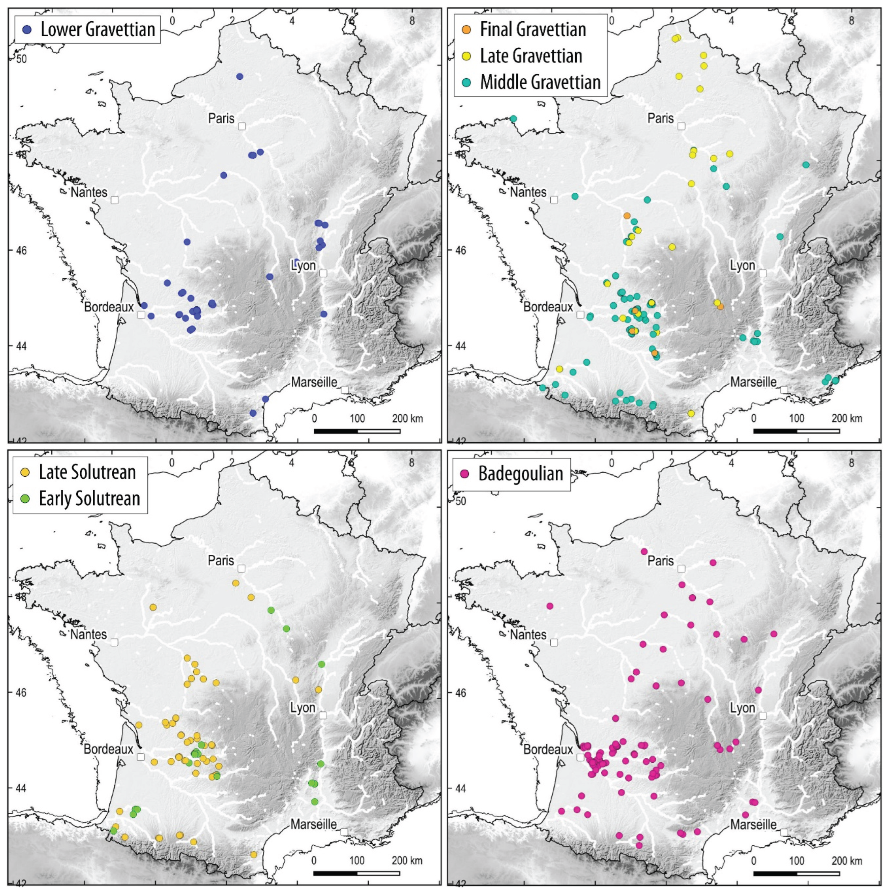
Figure 2.
Distribution in latitude and longitude of occurrences for the various technocomplexes considered.
Figure 2.
Distribution in latitude and longitude of occurrences for the various technocomplexes considered.
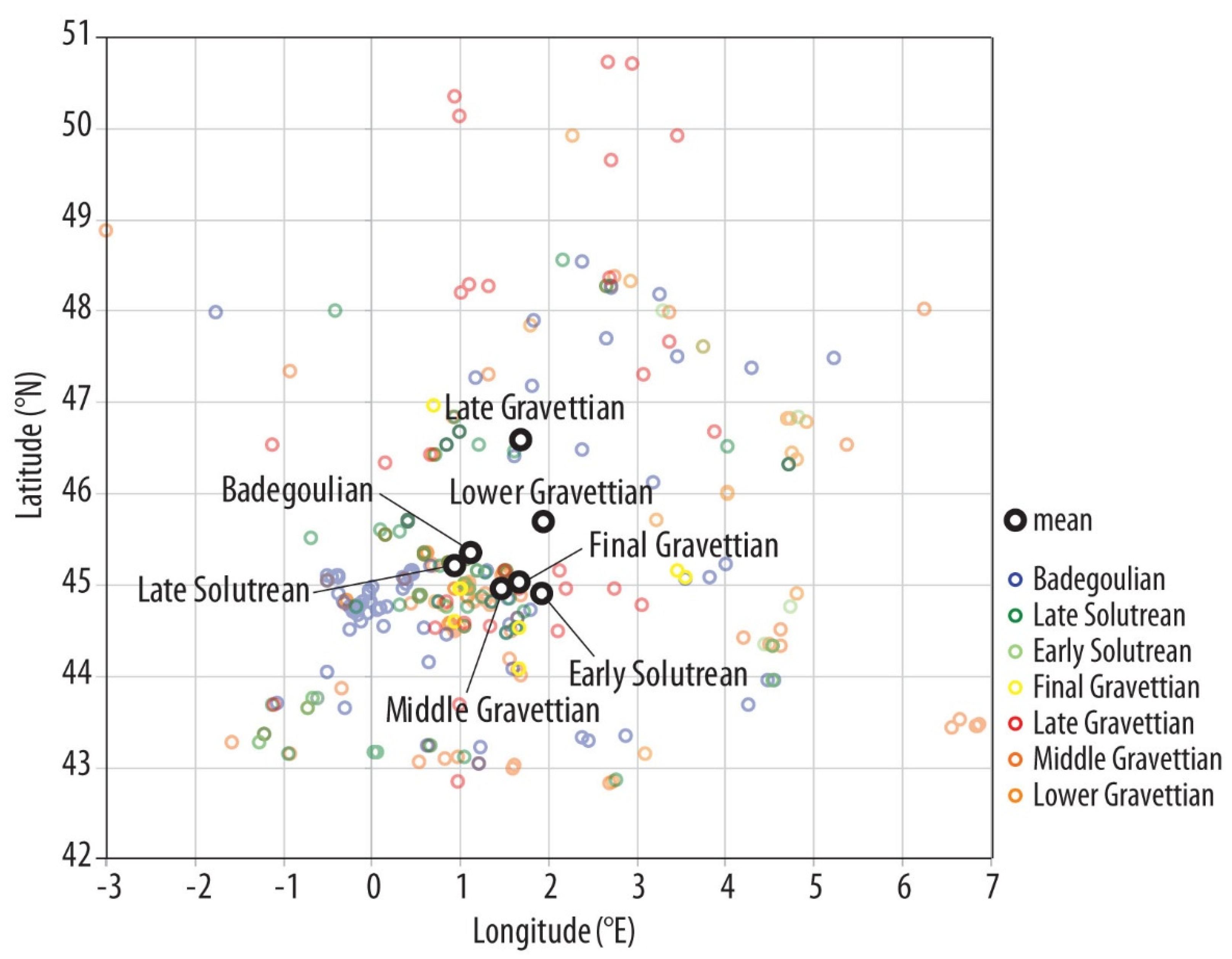
Figure 3.
A - Chronological distribution of the number of occurrences per technocomplex and per 1,000-year time interval; B - 95% interval of the chronological range of technocomplexes according to [37]. The 18O curve from the Greenland GRIP ice core is taken from [52]. GI: interstadial, GS: stadial.
Figure 3.
A - Chronological distribution of the number of occurrences per technocomplex and per 1,000-year time interval; B - 95% interval of the chronological range of technocomplexes according to [37]. The 18O curve from the Greenland GRIP ice core is taken from [52]. GI: interstadial, GS: stadial.
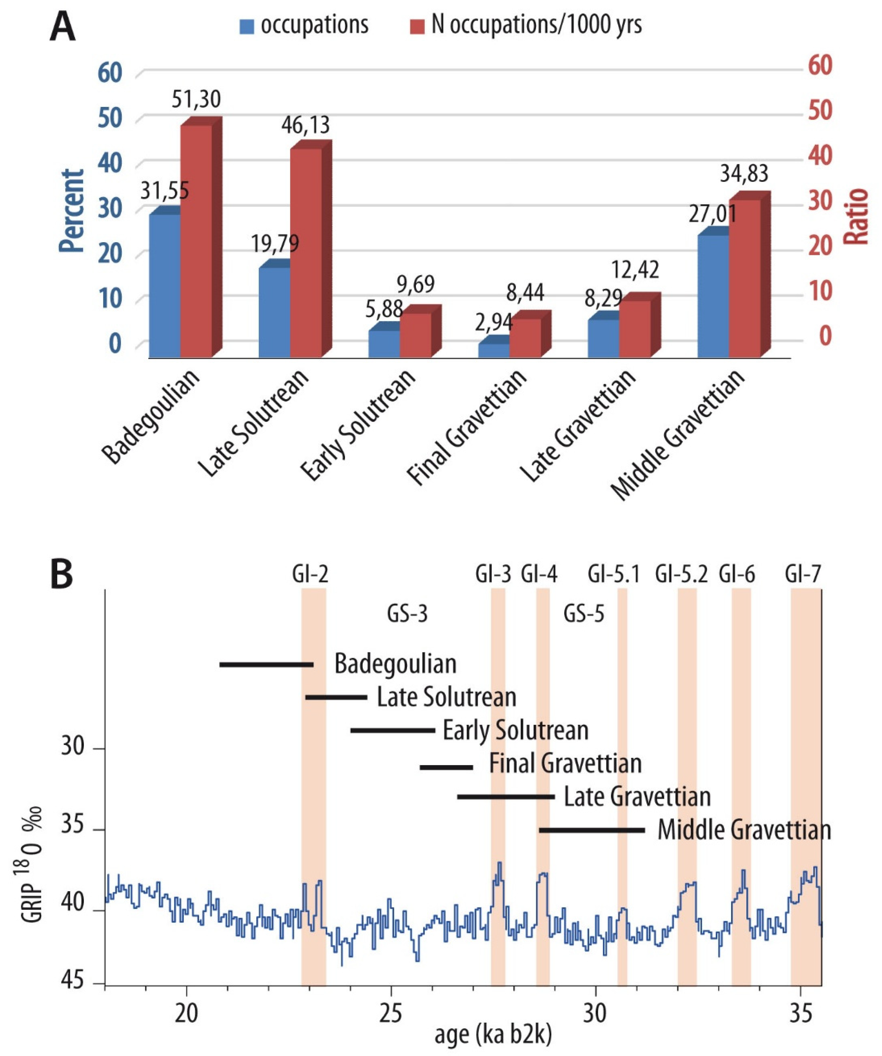
Figure 4.
CAVIAR preventive archaeology database (Inrap). A – Open trench area subject to archaeological survey by region, in km2 (ARA: Auvergne-Rhône-Alpes, BFC: Bourgogne-Franche Comté, CIF: Centre-Ile de France, GE: Grand Est, GO: Grand Ouest, HdF: Hauts de France, NAOM: Nouvelle Aquitaine, MM: Midi-Méditerranée); B – Ratio between the number of stratigraphic units containing Paleolithic remains and the open surface area (in km2).
Figure 4.
CAVIAR preventive archaeology database (Inrap). A – Open trench area subject to archaeological survey by region, in km2 (ARA: Auvergne-Rhône-Alpes, BFC: Bourgogne-Franche Comté, CIF: Centre-Ile de France, GE: Grand Est, GO: Grand Ouest, HdF: Hauts de France, NAOM: Nouvelle Aquitaine, MM: Midi-Méditerranée); B – Ratio between the number of stratigraphic units containing Paleolithic remains and the open surface area (in km2).
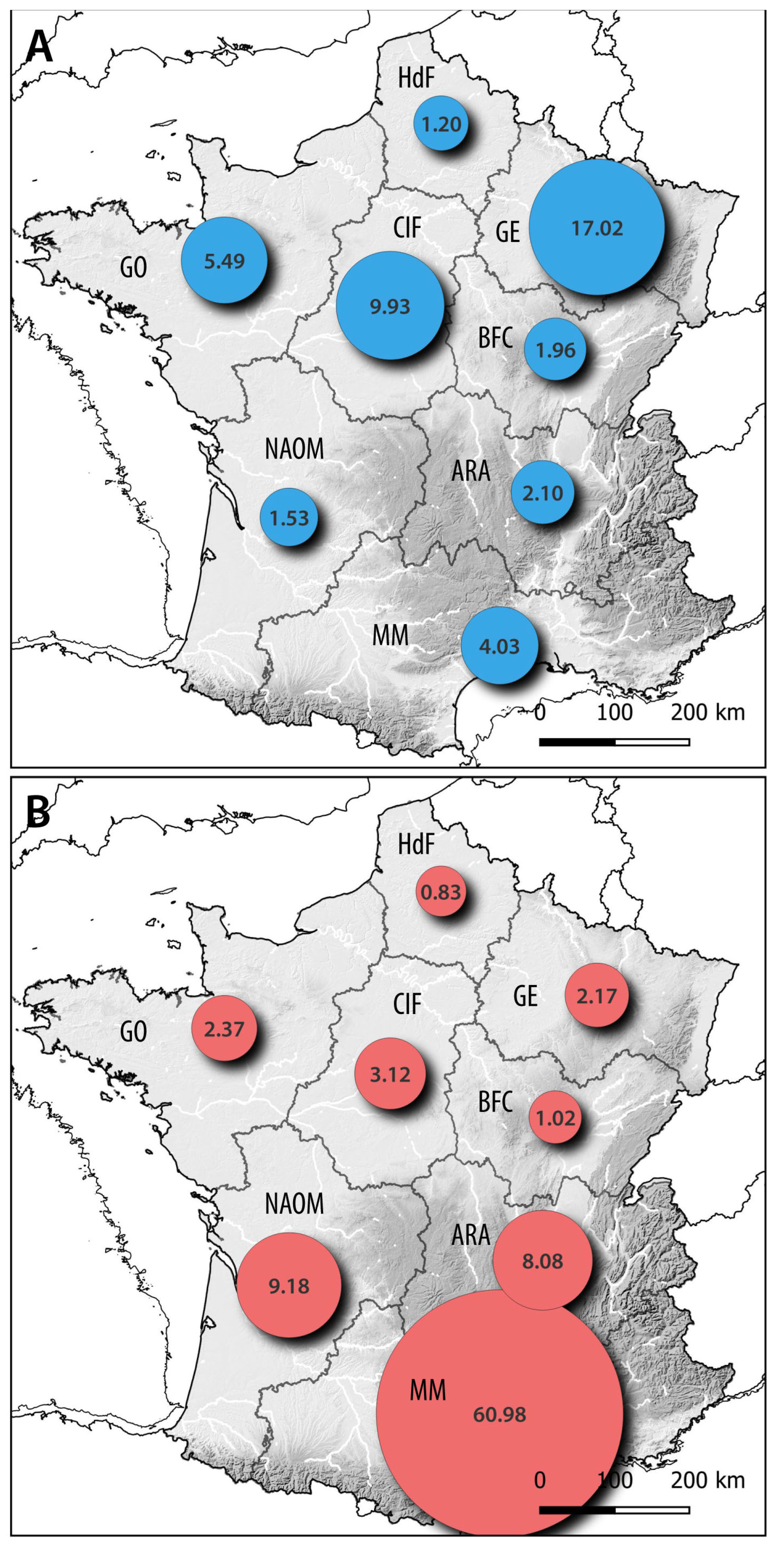
Figure 5.
Distribution of occurrences according to current land cover (CLC) and relative area of different cover types in France (excluding altitudes above 600 m).
Figure 5.
Distribution of occurrences according to current land cover (CLC) and relative area of different cover types in France (excluding altitudes above 600 m).
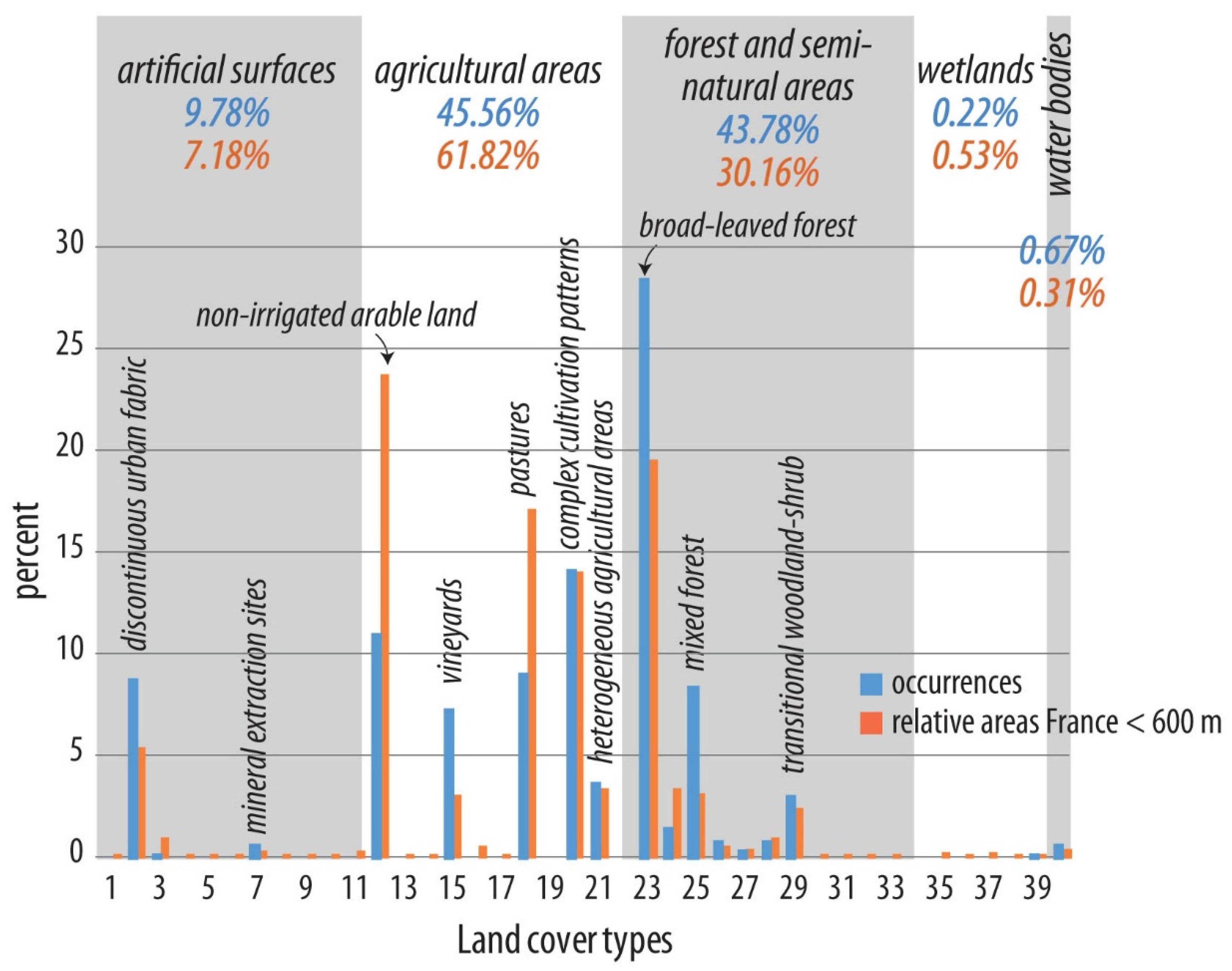
Figure 6.
A - Distribution of occurrences according to altitude in 20 m increments compared to the proportion of areas with the same altitude in France (< 600 m); B - Cumulative frequency of the altitude of occurrences and 95% confidence interval, compared to the cumulative frequency of 200 random point samples (in grey).
Figure 6.
A - Distribution of occurrences according to altitude in 20 m increments compared to the proportion of areas with the same altitude in France (< 600 m); B - Cumulative frequency of the altitude of occurrences and 95% confidence interval, compared to the cumulative frequency of 200 random point samples (in grey).
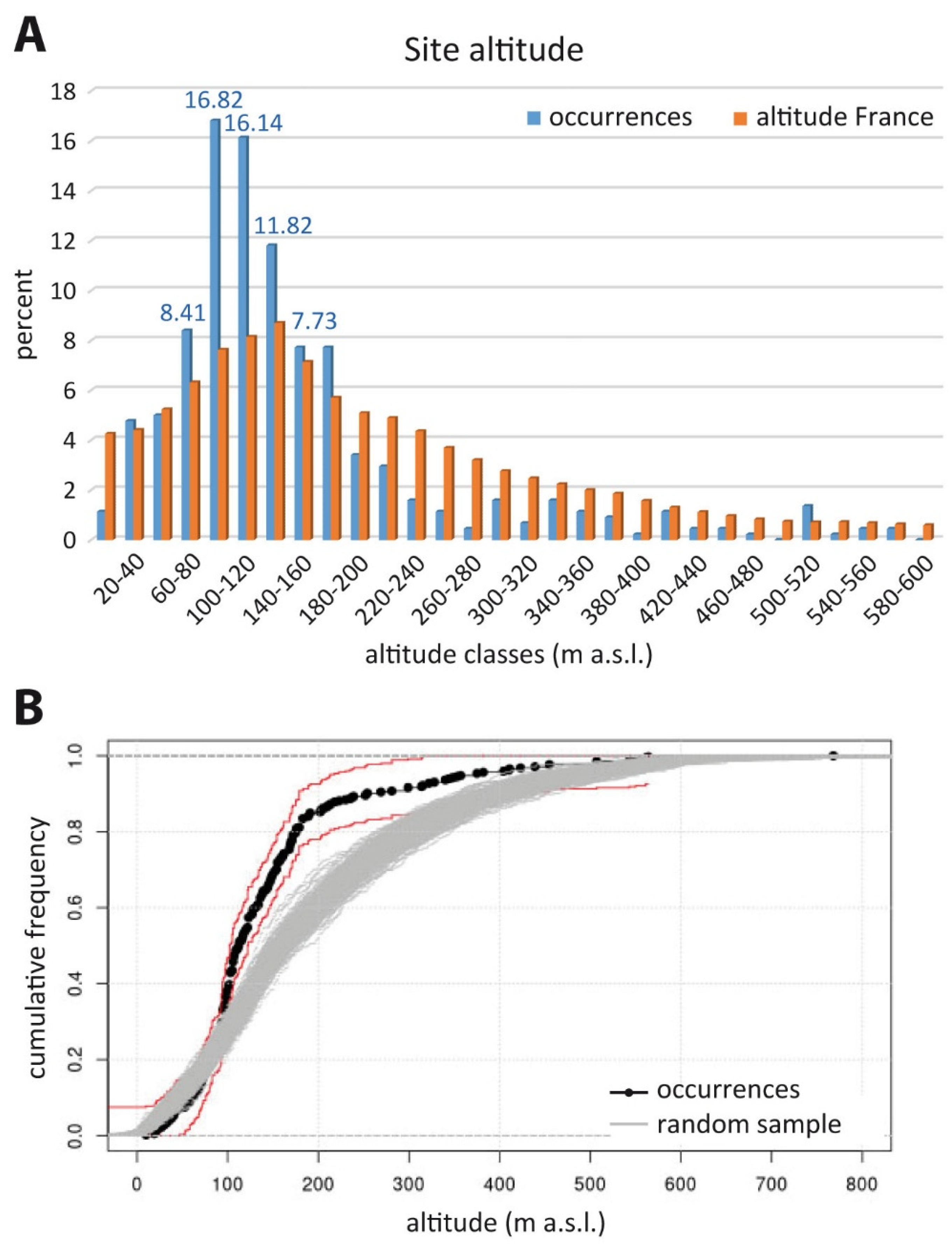
Figure 7.
A - Distribution of occurrences according to latitude per 1° interval compared to the proportion of areas with the same latitude in France (< 600 m); B - Cumulative frequency of the latitude of occurrences and 95% confidence interval, compared to the cumulative frequency of 200 random point samples (in grey).
Figure 7.
A - Distribution of occurrences according to latitude per 1° interval compared to the proportion of areas with the same latitude in France (< 600 m); B - Cumulative frequency of the latitude of occurrences and 95% confidence interval, compared to the cumulative frequency of 200 random point samples (in grey).
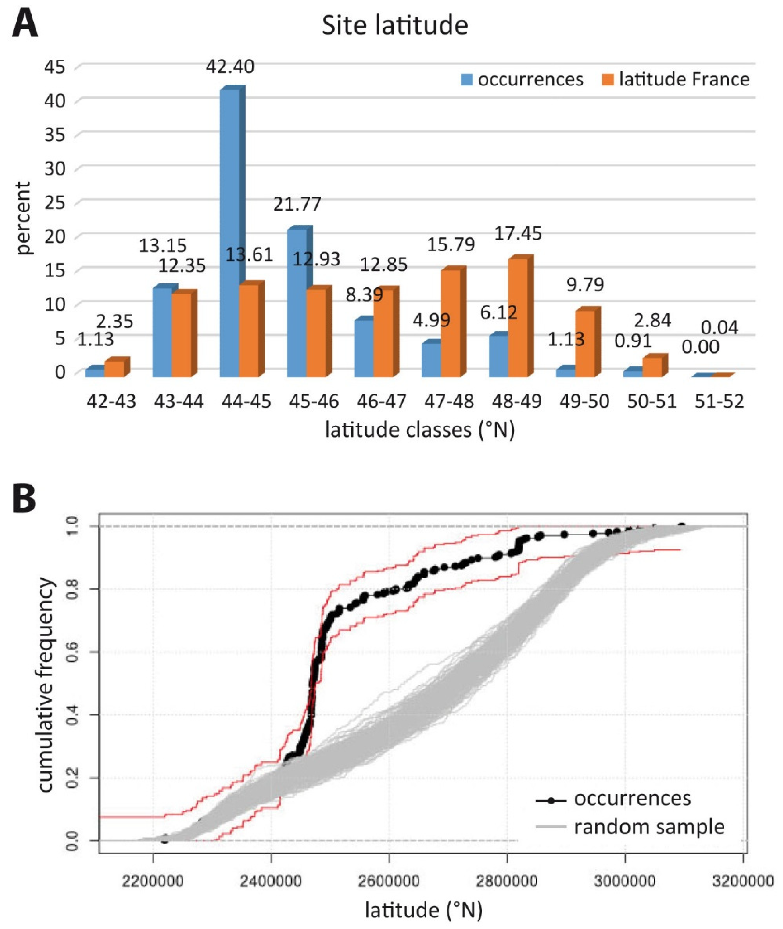
Figure 8.
Distribution of occurrences according to latitude and longitude; site types (cave, rockshelter, and open air) are indicated by symbols.
Figure 8.
Distribution of occurrences according to latitude and longitude; site types (cave, rockshelter, and open air) are indicated by symbols.
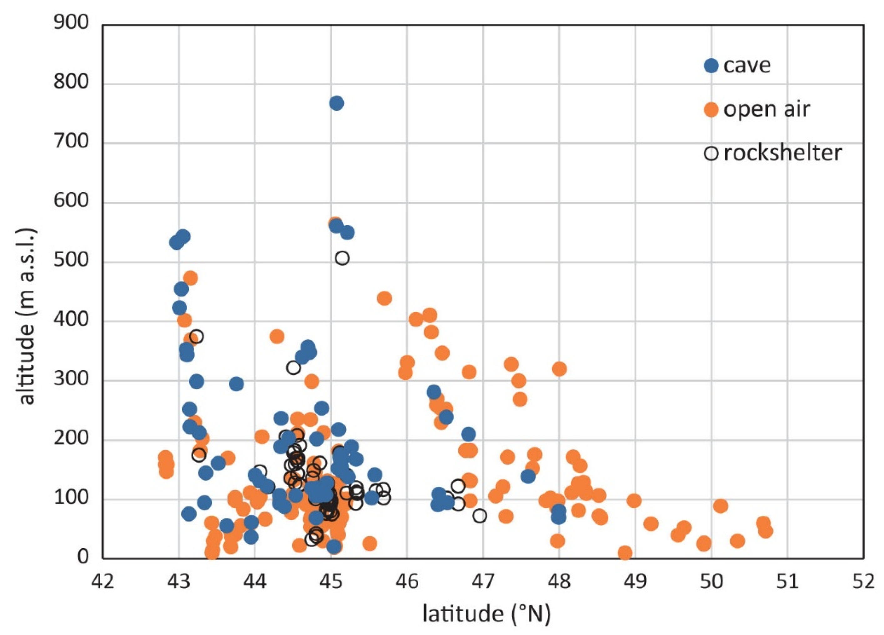
Figure 9.
Distribution of occurrences according to exposure, in 20° increments. Only sites with a slope greater than 5° were taken into account.
Figure 9.
Distribution of occurrences according to exposure, in 20° increments. Only sites with a slope greater than 5° were taken into account.
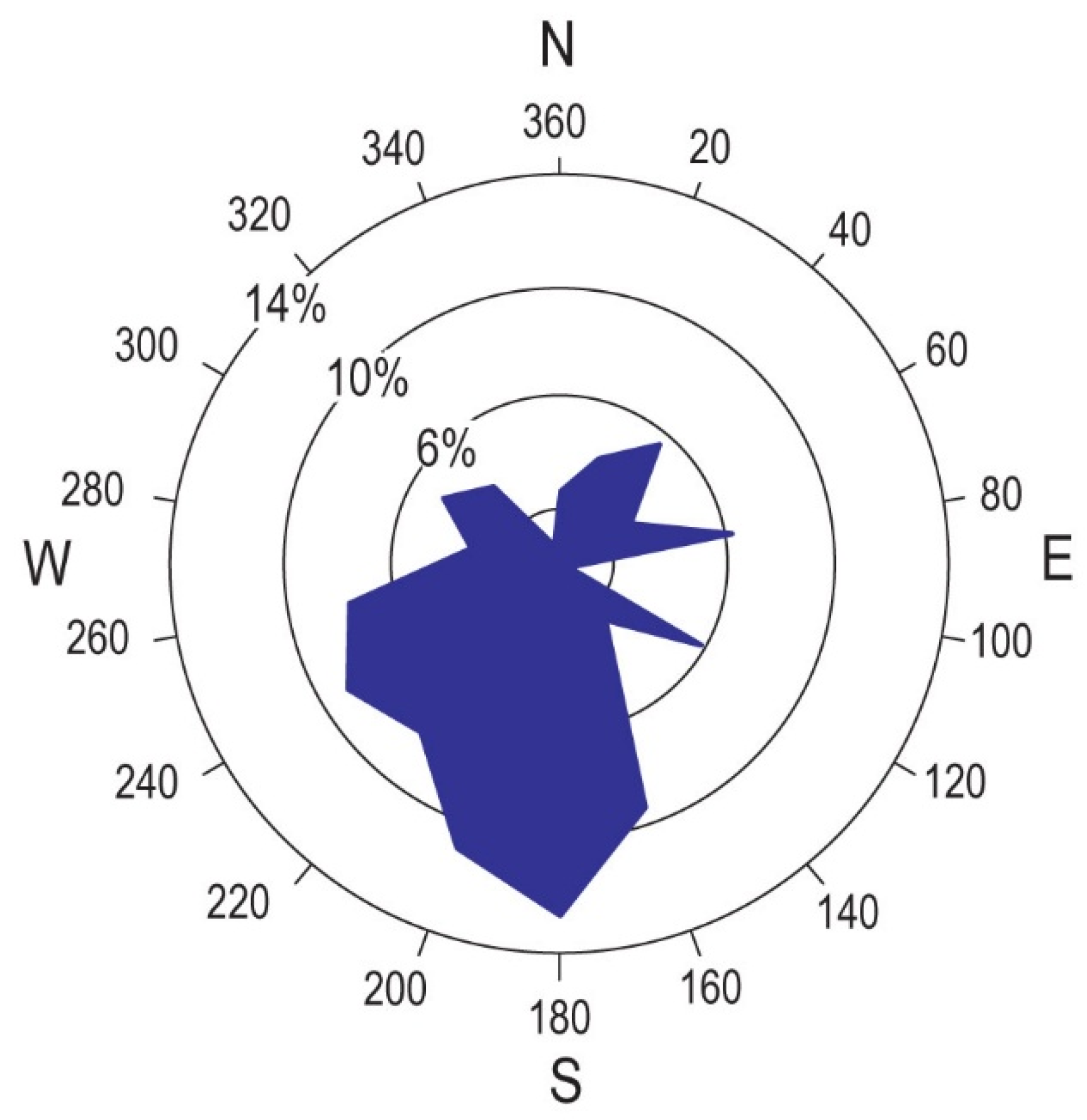
Figure 10.
Distribution of occurrences relative to the extent of permafrost during the LGM. Permafrost boundaries are taken from K.H. Stadelmaier in [64], ice sheet boundaries from [87].
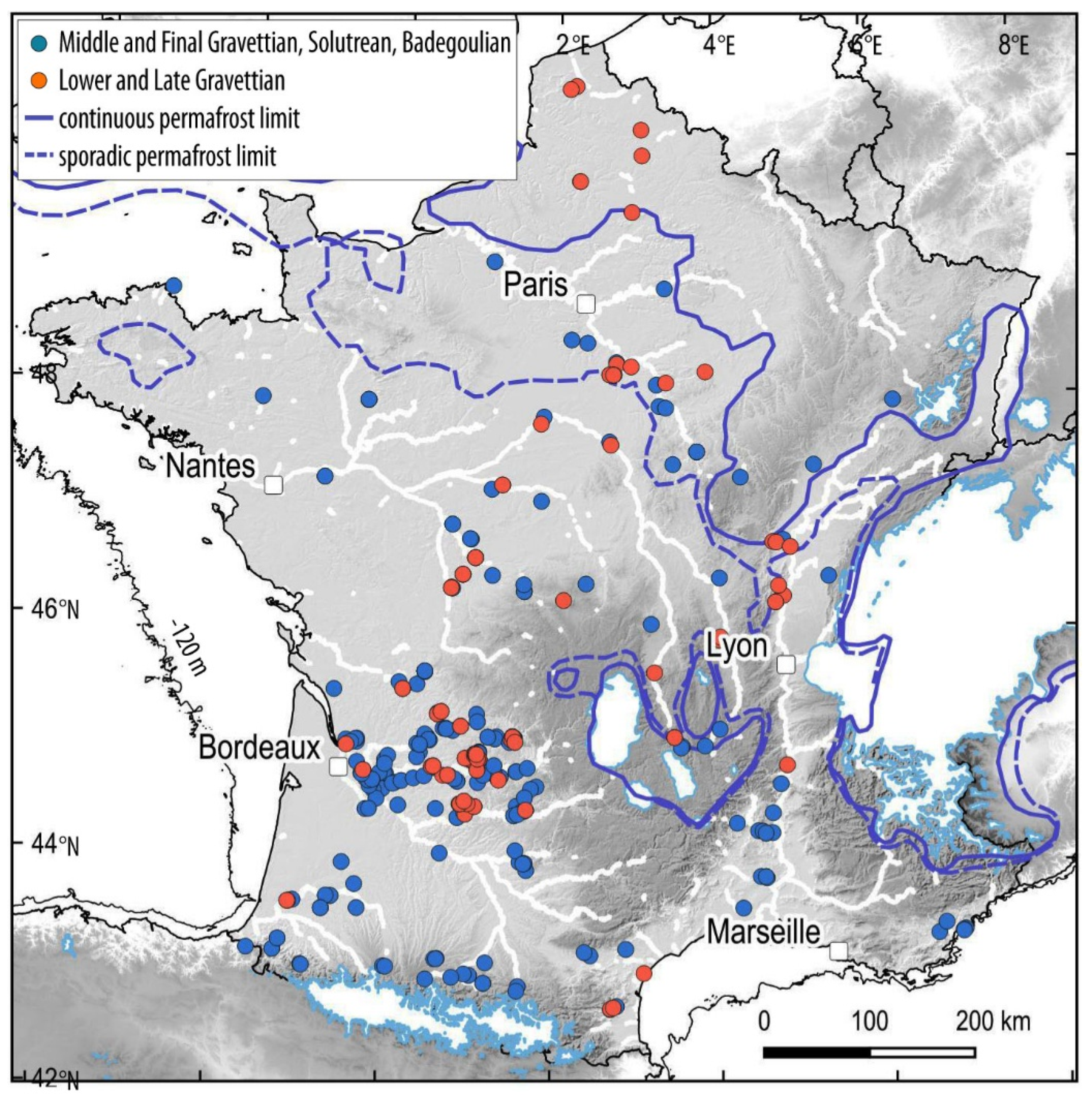
Figure 11.
Distribution of occurrences in relation to aeolian deposits. The map of aeolian deposits is taken from [61].
Figure 11.
Distribution of occurrences in relation to aeolian deposits. The map of aeolian deposits is taken from [61].
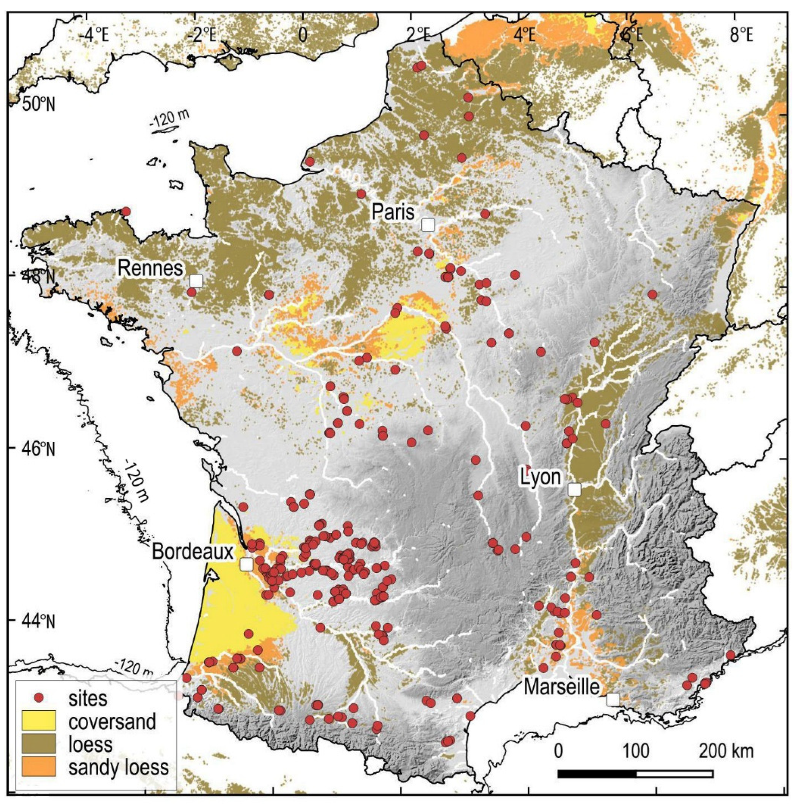
Figure 12.
Frequency of occurrences according to aeolian deposit types compared to the relative surface area of these deposits in France (< 600 m). A – Aeolian deposits according to [61]; B – Loess according to [63].
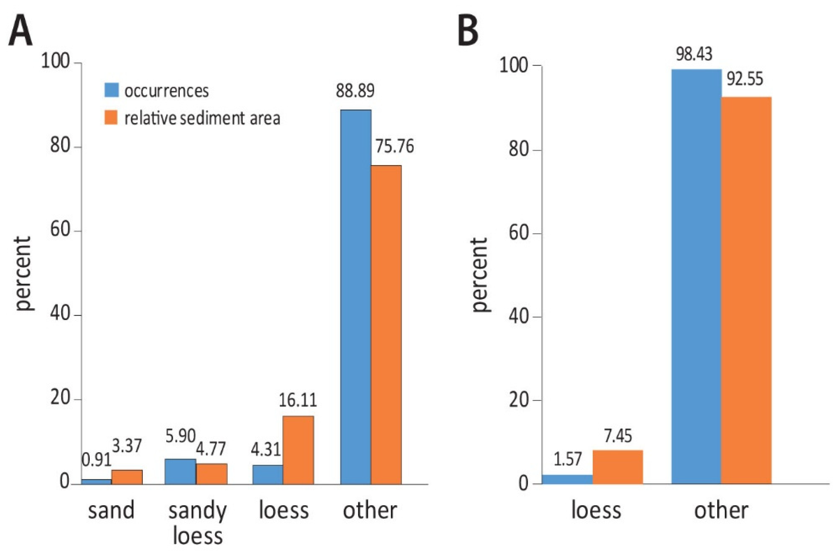
Figure 13.
Factor analysis of the distribution of occurrences (‘reference’) and 200 random point samples in France (<600 m) (numbers 1 to 100) according to the types of aeolian deposits.
Figure 13.
Factor analysis of the distribution of occurrences (‘reference’) and 200 random point samples in France (<600 m) (numbers 1 to 100) according to the types of aeolian deposits.
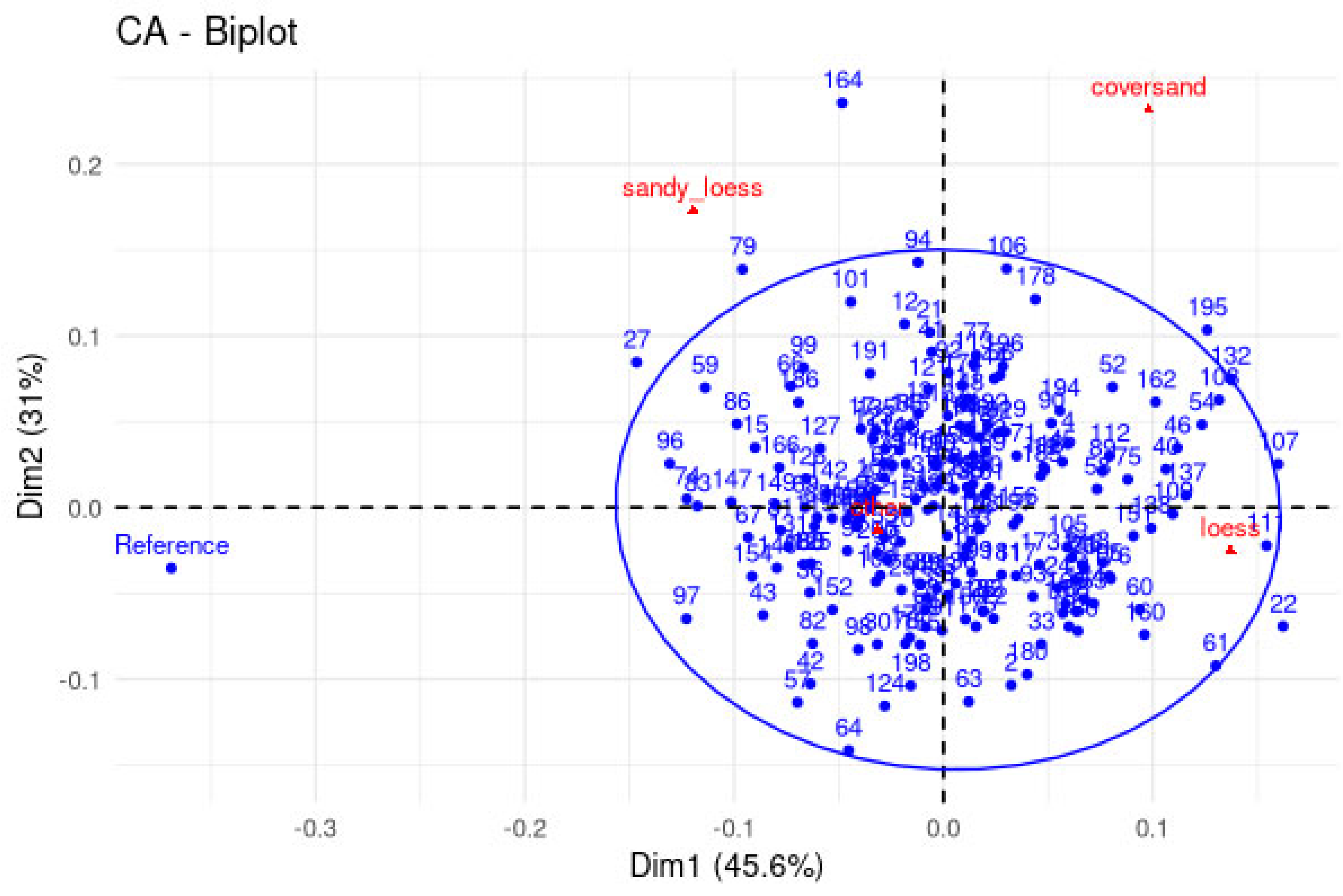
Figure 14.
Cumulative frequency of the distance of occurrences relative to a large river (width > 15 m) and 95% confidence interval, compared to the cumulative frequency of 200 random point samples (in grey).
Figure 14.
Cumulative frequency of the distance of occurrences relative to a large river (width > 15 m) and 95% confidence interval, compared to the cumulative frequency of 200 random point samples (in grey).
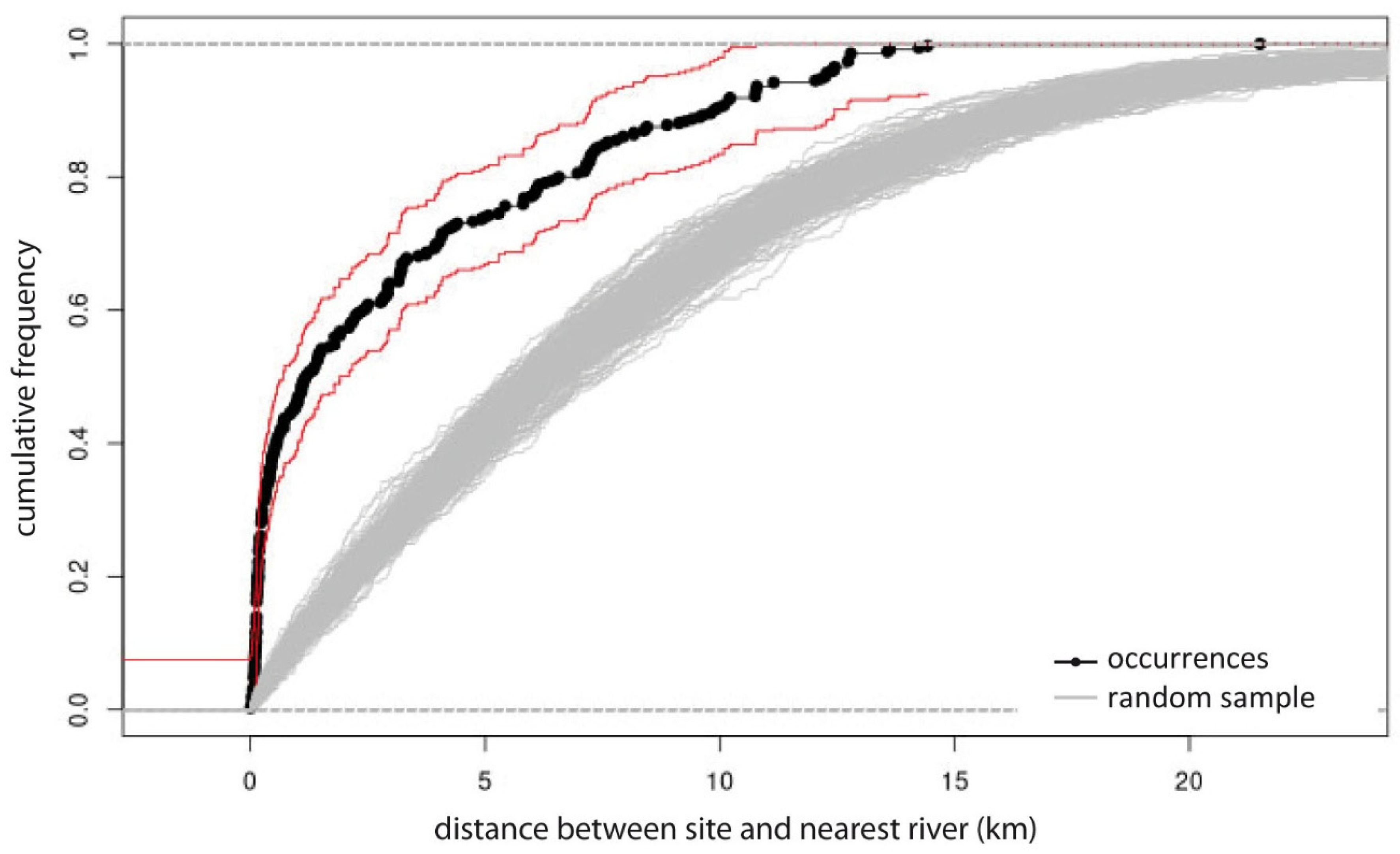
Figure 15.
Frequency of occurrences located on flint-bearing formations and within a maximum radius of 30 km around these formations (30 km buffer), compared to the proportion of areas occupied by flint-bearing formations in France (< 600 m).
Figure 15.
Frequency of occurrences located on flint-bearing formations and within a maximum radius of 30 km around these formations (30 km buffer), compared to the proportion of areas occupied by flint-bearing formations in France (< 600 m).
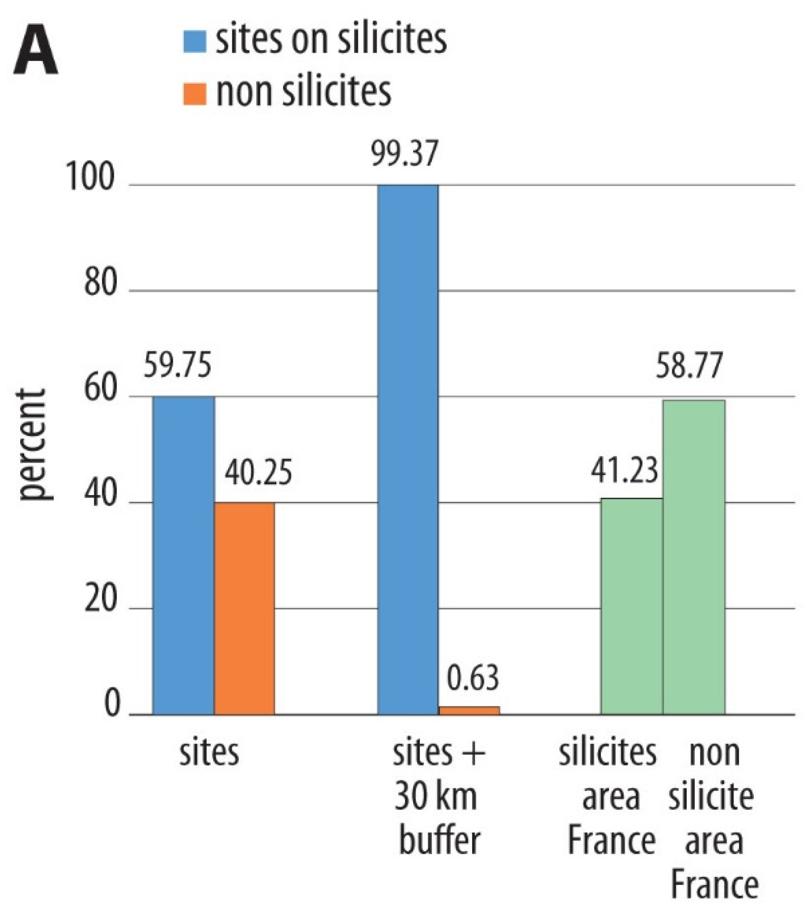
Figure 16.
Map of occurrences by site type (caves and rockshelters vs. open air) compared to the distribution of flint-bearing formations and granitoid and metamorphic bedrock in France.
Figure 16.
Map of occurrences by site type (caves and rockshelters vs. open air) compared to the distribution of flint-bearing formations and granitoid and metamorphic bedrock in France.
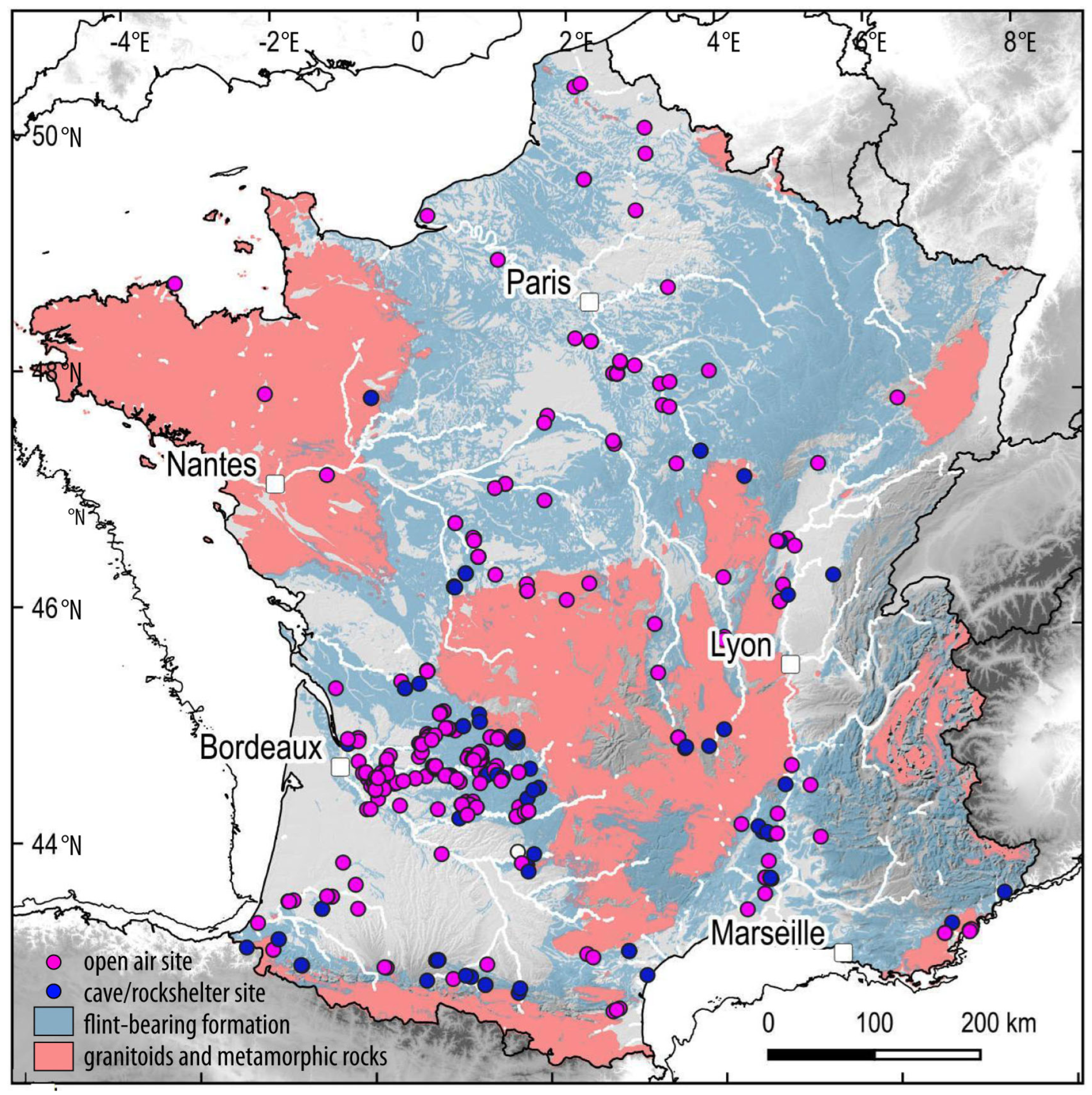
Figure 17.
Distribution of European Gravettian sites compared to that of aeolian deposits [61]. Sites from this database and the database of [17].
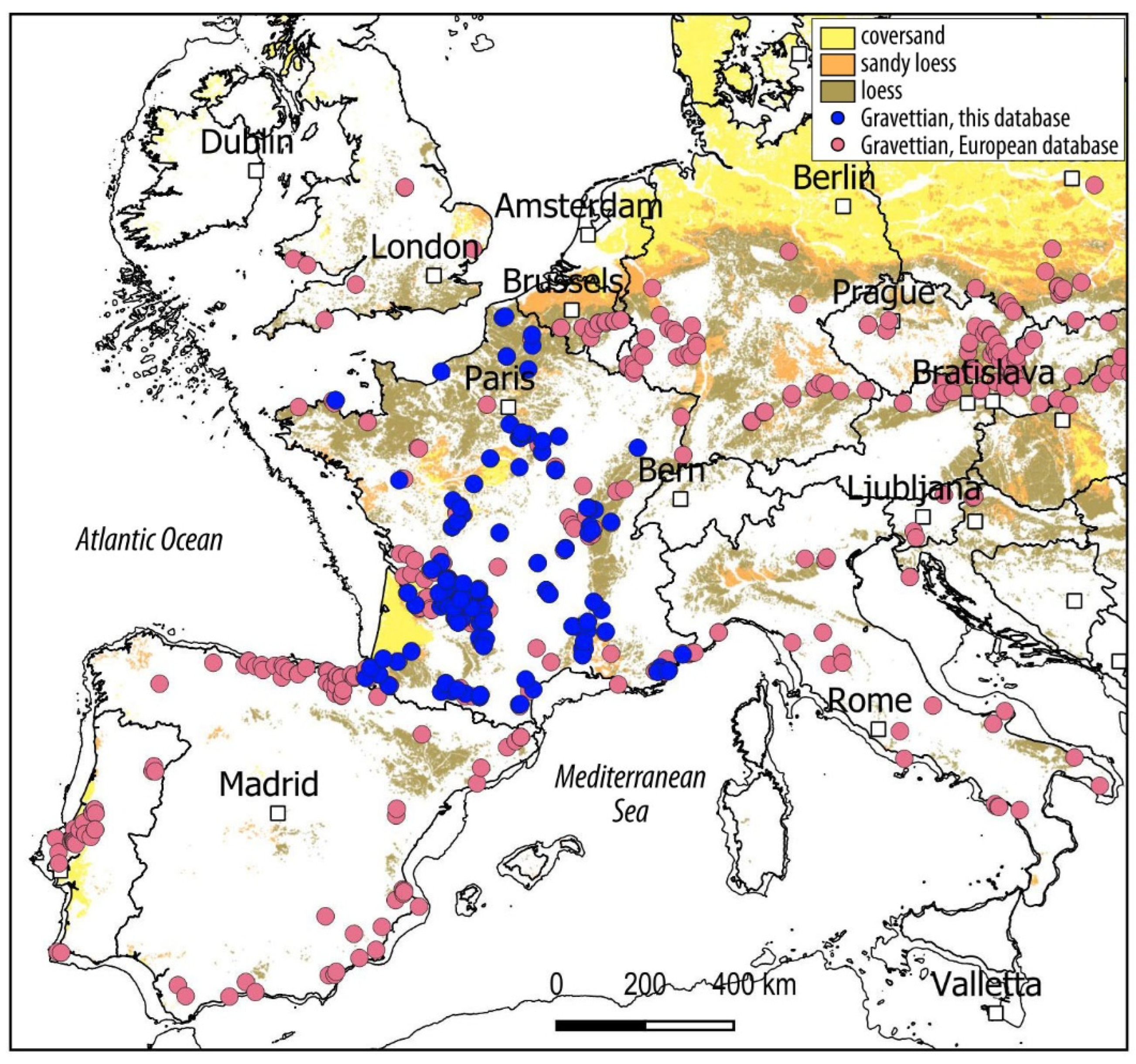
Figure 18.
Distribution of occurrences compared to those of calcareous formations potentially containing flint in Europe (according to [86]). A – Solutrean, Badegoulian, and Epigravettian sites from this database and the database of [13].
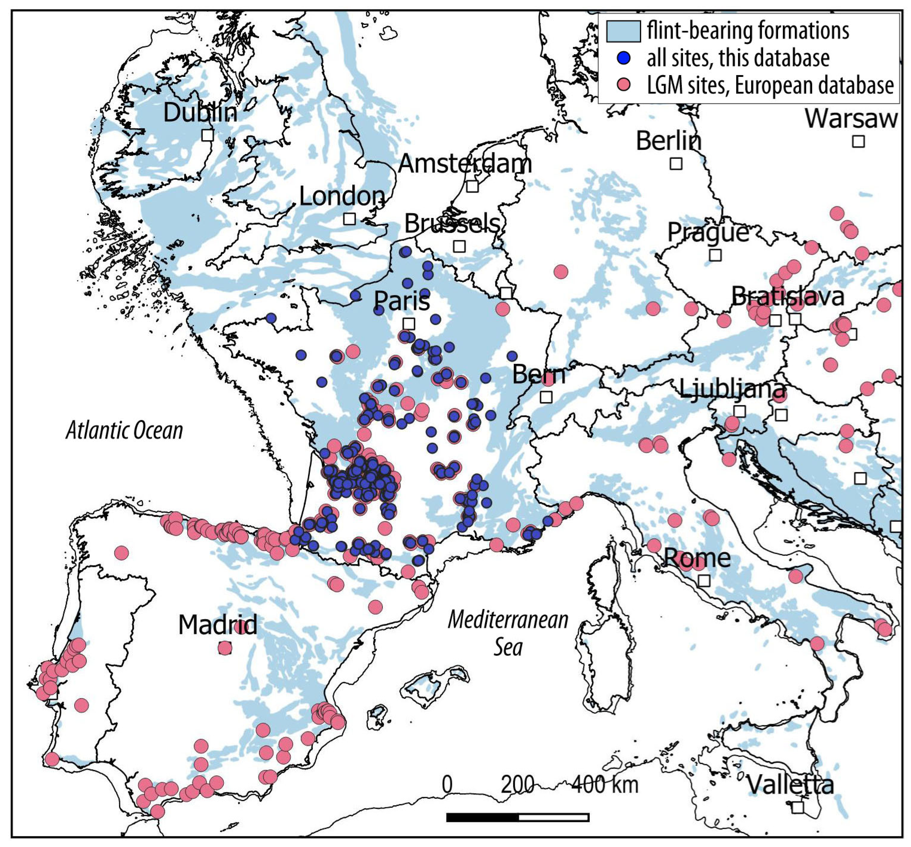

Table 1.
Database of Paleolithic occurrences used in the study and key bibliographic references.
| Site_Name | Latitude | Longitude | Precise_Coordinates | Altitude_DEM | SiteType | Layer | Technocomplex_1 | Technocomplex_2 | Technocomplex_3 | References | ||
|---|---|---|---|---|---|---|---|---|---|---|---|---|
| Amiens Renancourt 2 | 49.900354 | 2.267512 | TRUE | 25 | open air | unknown | Gravettian | Lower Gravettian | Paris et al. (2015) | |||
| Amiens-Renancourt 1 | 49.901447 | 2.264050 | TRUE | 27 | open air | unknown | Gravettian | Late Gravettian | Paris et al. (2013, 2017), Fagnart et al. (2013), Paris (2020) | |||
| Artigaux (Les) | 44.790879 | -0.300407 | TRUE | 52 | open air | unknown | Gravettian | Middle Gravettian | Rayssian | Lenoir (1977), Klaric (2003), Touzé (2013), Vignoles (unpublished) | ||
| Azé-Camping de Rizerolles | 46.438822 | 4.761287 | TRUE | 254 | open air | 3 | Gravettian | Lower Gravettian | Digan et al. (2008), Floss and Taller (2011), Floss et al. (2013) | |||
| Azkonzilo | 43.262272 | -1.262489 | TRUE | 175 | rockshelter | 6a, 6b | Solutrean | Early Solutrean | Lower Solutrean | Chauchat (2007) | ||
| Azkonzilo | 43.262272 | -1.262489 | TRUE | 175 | rockshelter | 4a, 4b, 4c, 5a, 5b sup, 5b inf | Solutrean | Late Solutrean | Chauchat (2007) | |||
| Badegoule | 45.136667 | 1.206944 | TRUE | 176 | rockshelter | I | Solutrean | Early Solutrean | Lower Solutrean | Cheynier (1939, 1949) | ||
| Badegoule | 45.136667 | 1.206944 | TRUE | 176 | rockshelter | I, II (1939); VI, VII (1949) | Badegoulian | Late Badegoulian | Cheynier (1939, 1949), Cretin (2000) | |||
| Badegoule | 45.136667 | 1.206944 | TRUE | 176 | rockshelter | II, III, IV, V, VI | Solutrean | Late Solutrean | Cheynier (1939, 1949) | |||
| Balette | 44.738700 | -0.216600 | FALSE | 72 | open air | surface | Badegoulian | Late Badegoulian | Lenoir (1998) | |||
| Ballancourt | 48.521023 | 2.378336 | TRUE | 107 | open air | single mixed layer (with Gravettian, Badegoulian, Mesolithic and Neolithic) | Badegoulian | Late Badegoulian | Delarue and Vignard (1964) | |||
| Ballancourt-rue de la Libération | 48.523826 | 2.374316 | TRUE | 73 | open air | unique level | Gravettian | Gravettian | Sarel (2015) | |||
| Balme (Grotte de la) | 46.513430 | 5.384680 | TRUE | 239 | cave | F | Gravettian | Middle Gravettian | Fornage-Bontemps (2010) | |||
| Bassaler-Nord (Grotte de) | 45.145004 | 1.503972 | TRUE | 168 | cave | 4 | Gravettian | Middle Gravettian | Noaillian/Rayssian | David (1985), Touzé (2011, 2013) | ||
| Battuts (Les) | 44.062408 | 1.671874 | TRUE | 147 | rockshelter | 9, 12 | Gravettian | Final Gravettian? | Alaux (1967, 1969, 1971, 1973), David (1985), Klaric (2003), Touzé (2013) | |||
| Battuts (Les) | 44.062408 | 1.671874 | TRUE | 147 | rockshelter | 5, 7 | Gravettian | Middle Gravettian | Noaillian | Alaux (1967, 1969, 1971, 1973), David (1985), Klaric (2003), Touzé (2013) | ||
| Baume d’Oullins | 44.341667 | 4.457778 | TRUE | 237 | cave | 6, 7, C.2 | Solutrean | Early Solutrean | Lower Solutrean | Combier (1967), Guégan (2007) | ||
| Baume Périgaud (La) | 43.756000 | 7.282900 | FALSE | 295 | cave | unknown | Gravettian | Gravettian | Onoratini (1982), Santaniello (2016) | |||
| Beauregard (Faleyras) | 44.752478 | -0.245497 | TRUE | 103 | open air | surface | Badegoulian | Late Badegoulian | Lenoir (1983) | |||
| Beauregard (Mazères) | 44.493500 | -0.240600 | FALSE | 109 | open air | surface | Badegoulian | Late Badegoulian | Lenoir et al. (1997) | |||
| Bel-air | 44.885400 | -0.028400 | FALSE | 56 | open air | unknown | Badegoulian | Late Badegoulian | Lenoir (1983, 1988) | |||
| Belle-Fontaine | 48.319677 | 2.935294 | TRUE | 129 | open air | surface | Gravettian | Lower Gravettian | Klaric et al. (2004) | |||
| Bellevue | 46.390400 | 1.615600 | FALSE | 270 | open air | unknown | Badegoulian | Late Badegoulian | Trotignon (1985), Chehmana et al. (2012) | |||
| Bellevue Cavignac | 45.090100 | -0.390600 | FALSE | 70 | open air | unknown | Badegoulian | Late Badegoulian | Lenoir (1983, 1988) | |||
| Bergerie (Abri de la) | 44.478900 | 1.577800 | TRUE | 158 | rockshelter | 2 | Gravettian | Gravettian | Clottes et al. (1990), Touzé (2013) | |||
| Bergerie (Abri de la) | 44.478900 | 1.577800 | TRUE | 158 | rockshelter | 1 | Gravettian | Middle Gravettian | Noaillian | Clottes et al. (1990), Touzé (2013) | ||
| Bernarderie (La) | 44.956200 | 0.006200 | FALSE | 90 | open air | unknown | Badegoulian | Late Badegoulian | Lenoir (1983, 1988) | |||
| Bernoux (Abri des) | 45.329700 | 0.589900 | TRUE | 120 | rockshelter | unique level? | Solutrean | Late Solutrean? | Smith (1966), Daniel (1967) | |||
| Birac | 44.893600 | -0.364500 | FALSE | 30 | open air | surface | Badegoulian | Late Badegoulian | Crochet (1967), Lenoir (1983, 2000), Ducasse (unpublished) | |||
| Blot (Le) | 45.146995 | 3.464130 | TRUE | 507 | rockshelter | 22, 23, 24, 27, 28, 32, 42 , 48 | Gravettian | Final Gravettian | Buisson (1980), Delporte and Virmont (1983), Djindjian (2003), Klaric (2000, 2003), Surmely and Hays. (2011), Guillermin (2011), Raynal and Delvignes (2022) | |||
| Blot (Le) | 45.146995 | 3.464130 | TRUE | 507 | rockshelter | 9 to 18 (Virmont), nappe B and UA3a (Delvigne, Raynal) | Badegoulian | Late Badegoulian | Delporte (1968), Virmont (1981), Delvigne, Raynal dir. (2024) | |||
| Blot (Le) | 45.146995 | 3.464130 | TRUE | 507 | rockshelter | unknown | Gravettian | Late Gravettian | Buisson (1980), Delporte and Virmont (1983), Djindjian (2003), Klaric (2000, 2003), Surmely and Hays. (2011), Guillermin (2011), Raynal and Delvignes (2022) | |||
| Bois de la Nauve | 45.092800 | -0.375300 | FALSE | 41 | open air | surface | Badegoulian | Late Badegoulian | Lenoir (1983, 1988) | |||
| Bois de Touaa | 43.076000 | 0.839000 | FALSE | 402 | open air | unknown | Gravettian | Middle Gravettian | Clottes (1985), Foucher et al. (2008), Touzé (2013) | |||
| Bois des Beauregards-Bois des Beauregards | 48.247808 | 2.706254 | TRUE | 120 | open air | A ou IV (Daniel), C (Nouel), 4 (Martin) | Badegoulian | Late Badegoulian | Daniel (1937, 1939), Schmider (1971) | |||
| Bois des Beauregards-Bois des Chénes | 48.249300 | 2.710100 | FALSE | 123 | open air | unknown | Badegoulian | Late Badegoulian | Delarue and Vignard, 1960 | |||
| Bois des Beauregards-Bois des Chénes | 48.249300 | 2.710100 | FALSE | 123 | open air | unknown | Gravettian | Lower Gravettian | Daniel (1937), Schmider (1971) | |||
| Bois des Beauregards-Bois des Pins | 48.249300 | 2.710100 | FALSE | 123 | open air | unknown | Badegoulian | Late Badegoulian | Delarue and Vignard, 1963 | |||
| Bombetterie | 45.141100 | 1.314000 | FALSE | 89 | open air | surface | Badegoulian | Late Badegoulian | Cheynier (1956), Demars (1973), Chehmana (2011) | |||
| Bonhomme (Abri du) | 45.347000 | 0.634000 | FALSE | 110 | rockshelter | unknown | Gravettian | Middle Gravettian? | de Sonneville-Bordes (1960), Movius and Rigaud (1995) | |||
| Bordeneuve | 44.515040 | 0.600281 | TRUE | 134 | open air | unique level | Badegoulian | Late Badegoulian | Ferullo (1995), Ferullo et al. (1999) | |||
| Bos-del-Ser / Bouétou (Grotte de) | 45.122693 | 1.492542 | TRUE | 176 | cave | unknown | Gravettian | Gravettian | David (1985) | |||
| Bossats (les)/ Ormesson | 48.251154 | 2.661604 | TRUE | 82 | open air | solutrean level | Solutrean | Late Solutrean | Bodu et al. (2019) | |||
| Bossats (les)/ Ormesson | 48.251154 | 2.661604 | TRUE | 82 | open air | gravettian level | Gravettian | Lower Gravettian | Bodu et al. (2019) | |||
| Boulazac / Le Landry | 45.186996 | 0.780357 | TRUE | 93 | open air | unique level | Solutrean | Late Solutrean | Upper Solutrean | Brenet (2014) | ||
| Bouverie (Grotte de la) | 43.515734 | 6.650195 | TRUE | 161 | cave | unknown | Gravettian | Middle Gravettian | Noaillian | Onoratini (1982), David (1985), Bazile (2007), Touzé (2013), Santaniello (2016) | ||
| Bouyssonie (Grotte) | 45.144775 | 1.504804 | TRUE | 169 | cave | unknown | Gravettian | Late Gravettian | Pesesse and Beauval (2013), Touzé (2013), Klaric (2017), Delvigne et al. (2020) | |||
| Bouyssonie (Grotte) | 45.144775 | 1.504804 | TRUE | 169 | cave | median unit (lower part) | Solutrean | Late Solutrean | Upper Solutrean | Langlais et al. (2019) | ||
| Bouyssonie (Grotte) | 45.144775 | 1.504804 | TRUE | 169 | cave | unknown | Gravettian | Middle Gravettian | Noaillian | Pesesse and Beauval (2013), Touzé (2013), Klaric (2017), Delvigne et al. (2020) | ||
| Bouyssonie (Grotte) | 45.144775 | 1.504804 | TRUE | 169 | cave | unknown | Gravettian | Middle Gravettian | Rayssian | Pesesse and Beauval (2013), Touzé (2013), Klaric (2017), Delvigne et al. (2020) | ||
| Bouyssou | 45.150100 | 0.443600 | FALSE | 136 | open air | surface | Badegoulian | Late Badegoulian | Gaussen (1980), Fourloubey (1998) | |||
| Brassempouy/Grotte du Pape | 43.629800 | -0.718614 | TRUE | 56 | cave | porche a,nd inside (Dubalen, de Laporterie) + layer C, sector “Avenue” ; “galerie du Puits” (Piette) | Solutrean | Early Solutrean | Lower Solutrean | Renard and Bon (2015) | ||
| Brassempouy/Grotte du Pape | 43.629800 | -0.718614 | TRUE | 56 | cave | porche a,nd inside (Dubalen, de Laporterie) + layer C, sector “Avenue” ; “galerie du Puits” (Piette) | Solutrean | Late Solutrean | Renard and Bon (2015) | |||
| Brassempouy/Grotte du Pape | 43.629800 | -0.718614 | TRUE | 56 | cave | unknown | Gravettian | Middle Gravettian | Noaillian | Klaric (2003), Simonet (2009, 2011), Touzé (2013) | ||
| Braugnes (Les) | 44.551465 | 1.565965 | TRUE | 208 | rockshelter | 1, 2 and 3 | Badegoulian | Late Badegoulian | Allard (1983), Ducasse (2013) | |||
| Breuil-Durand (Le) | 47.978604 | -1.749701 | TRUE | 30 | open air | surface | Badegoulian | Late Badegoulian | Blanchet (1999) | |||
| Briqueterie Coquempot | 50.685254 | 2.128747 | TRUE | 60 | open air | unknown | Gravettian | Late Gravettian | Fagnart et al. (2013), Paris (2020) | |||
| Briqueterie Dupray | 49.561758 | 0.227156 | TRUE | 40 | open air | unknown | Gravettian | Gravettian | Guette-Marsac et al. (2009, 2013), Paris (2020) | |||
| Butte des Queyrons (La) | 44.693300 | -0.202900 | FALSE | 98 | open air | surface | Badegoulian | Late Badegoulian | Lenoir (1983) | |||
| Cabannes | 44.031719 | -0.496874 | TRUE | 96 | open air | unique level | Badegoulian | Late Badegoulian | Gellibert and Merlet (2001), Ducasse (2010) | |||
| Cabre (la) | 43.444800 | 6.848100 | FALSE | 15 | open air | unknown | Gravettian | Middle Gravettian | ||||
| Caillou (Le) | 44.791600 | 0.448500 | FALSE | 146 | open air | 52 to 37 | Gravettian | Middle Gravettian | Noaillian | Boyer et al. (1984), Touzé (2013) | ||
| Callan (Le) | 44.584634 | 0.937087 | TRUE | 191 | rockshelter | III, IV | Gravettian | Final Gravettian | Morala (2011), Touzé (2013) | |||
| Callan (Le) | 44.584634 | 0.937087 | TRUE | 191 | rockshelter | unknown | Gravettian | Lower Gravettian? | Morala (2011), Touzé (2013) | |||
| Callan (Le) | 44.584634 | 0.937087 | TRUE | 191 | rockshelter | I, II | Gravettian | Middle Gravettian | Noaillian | Morala (2011), Touzé (2013) | ||
| Camp de la Hire | 44.921400 | -0.027800 | FALSE | 111 | open air | surface | Badegoulian | Late Badegoulian | Lenoir (1983, 1988) | |||
| Camparnaud | 43.937900 | 4.549500 | FALSE | 112 | open air | surface | Badegoulian | Late Badegoulian | Bazile (1977) | |||
| Canolle Ferme | 44.855963 | 0.559591 | TRUE | 66 | open air | unknown | Gravettian | Gravettian | Bourguignon and Ortega-Cordellat (2012) | |||
| Cantelouve (Abri de) | 44.894133 | 1.288013 | TRUE | 109 | rockshelter | unknown | Gravettian | Middle Gravettian | Tixier (1958), David (1985) | |||
| Carane-3 (Grotte de la) | 42.970000 | 1.600000 | FALSE | 533 | cave | 1.2 | Gravettian | Middle Gravettian | Noaillian | David (1985), Foucher et al. (1999, 2008), Foucher (2004), Simonet (2009), Touzé (2013) | ||
| Cassegros | 44.442834 | 0.859557 | TRUE | 204 | cave | 9 | Badegoulian | Late Badegoulian | Le Tensorer (1981) ; Ducasse and Ferullo (2017, 2019) ; Ducasse, Ferullo, Le Tensorer et al. (unpublished) | |||
| Cassegros | 44.442834 | 0.859557 | TRUE | 204 | cave | 10 | Badegoulian | Lower Badegoulian? | Le Tensorer (1981) ; Ducasse and Ferullo (2017, 2019) ; Ducasse, Ferullo, Le Tensorer et al. (unpublished) | |||
| Casserole | 44.936450 | 1.014351 | TRUE | 106 | rockshelter | NA8, NA8b | Solutrean | Early Solutrean | Lower Solutrean | Detrain et al. (1992), Aubry and Almeida (2013), Ducasse et al. (2020) | ||
| Casserole | 44.936450 | 1.014351 | TRUE | 106 | rockshelter | NA9, NA10a | Solutrean | Early Solutrean | Protosolutrean | Detrain et al. (1992), Aubry and Almeida (2013), Ducasse et al. (2020) | ||
| Casserole | 44.936450 | 1.014351 | TRUE | 106 | rockshelter | NA10b | Gravettian | Final Gravettian | Detrain et al. (1994), Aubry et al. (1995), Lenoble and Cosgrove (2012), Ducasse et al. (2020) | |||
| Casserole | 44.936450 | 1.014351 | TRUE | 106 | rockshelter | NA4, NA5 | Badegoulian | Late Badegoulian | Detrain et al. (1992), Morala (1993), Ducasse et al. (2020) | |||
| Casserole | 44.936450 | 1.014351 | TRUE | 106 | rockshelter | NA7, NA7b | Solutrean | Late Solutrean | Upper Solutrean | Detrain et al. (1992), Aubry and Almeida (2013), Ducasse et al. (2020) | ||
| Casserole | 44.936450 | 1.014351 | TRUE | 106 | rockshelter | NA6 | Badegoulian | Lower Badegoulian | Detrain et al. (1992), Morala (1993), Ducasse et al. (2020) | |||
| Casserole | 44.936450 | 1.014351 | TRUE | 106 | rockshelter | NA11, NA12 | Gravettian | Middle Gravettian | Detrain et al. (1994), Aubry et al. (1995), Ducasse et al. (2020) | |||
| Casseuil | 44.585100 | -0.113900 | FALSE | 23 | open air | surface | Badegoulian | Late Badegoulian | Lenoir (1983, 1988) | |||
| Catigny | 49.639058 | 2.945764 | TRUE | 53 | open air | unknown | Gravettian | Late Gravettian | Paris (2020) | |||
| Celle-Saint-Cyr | 47.981502 | 3.290097 | TRUE | 98 | open air | surface | Solutrean | Early Solutrean | Lower Solutrean | Renard (2000, 2002), Bodu and Renard (2013) | ||
| Côte 132 | 44.134700 | 0.660700 | FALSE | 67 | open air | surface | Badegoulian | Late Badegoulian | Le Tensorer (1981) | |||
| Chabot (Grotte) | 44.321839 | 4.544094 | TRUE | 107 | cave | g (cave), 1 and 2 (porche) | Solutrean | Early Solutrean | Lower Solutrean | Combier (1967) | ||
| Champ (Grotte de) | 45.132360 | 1.523331 | TRUE | 151 | cave | unspecified | Solutrean | Late Solutrean | Bardon et al. (1924), Daniel (1969) | |||
| Champ (Grotte de) | 45.132360 | 1.523331 | TRUE | 151 | cave | unspecified | Gravettian | Middle Gravettian | Noaillian | Daniel (1969), David (1985), Touzé (2013) | ||
| Chamvres | 47.966470 | 3.374210 | TRUE | 86 | open air | unknown | Gravettian | Middle Gravettian | Connet and Lhomme (1992), Klaric (2013) | |||
| Chapelle (La) | 44.719000 | 0.075500 | FALSE | 125 | open air | surface | Badegoulian | Late Badegoulian | Lenoir (1983, 1988) | |||
| Chapelle-Saint-Mesmin (La) | 47.885000 | 1.832000 | TRUE | 103 | open air | surface | Badegoulian | Late Badegoulian | Nouel (1937) | |||
| Charbonnier à Roches (Abri) | 46.671212 | 1.003261 | TRUE | 93 | rockshelter | unknown | Gravettian | Late Gravettian? | Primault (2003), Klaric (2003), Touzé (2013), Aubry et al. (2013), Delvigne (2016) | |||
| Charbonnier à Roches (Abri) | 46.671212 | 1.003261 | TRUE | 93 | rockshelter | unknown | Gravettian | Middle Gravettian | Primault (2003), Klaric (2003), Touzé (2013), Aubry et al. (2013), Delvigne (2016) | |||
| Charlie (La) | 45.117989 | 0.478037 | TRUE | 80 | open air | surface | Badegoulian | Late Badegoulian | Gaussen (1980) | |||
| Chasseur (Abri du) | 45.689000 | 0.419800 | TRUE | 103 | rockshelter | S | Solutrean | Late Solutrean | Balout (1965) | |||
| Chasseur (Abri du) | 45.689000 | 0.419800 | TRUE | 103 | rockshelter | unknown | Gravettian | Middle Gravettian | Noaillian | Tixier (1958), David (1985), Touzé (2013) | ||
| Château de Neuvic | 45.103300 | 0.475500 | FALSE | 62 | open air | surface | Badegoulian | Late Badegoulian | Gaussen (1980) | |||
| Chatenet (Le) | 45.067140 | 0.351225 | TRUE | 122 | open air | 2 | Badegoulian | Late Badegoulian | Gaussen and Moissat (1990), Fourloubey (1996), Ducasse et al. (2022) | |||
| Chemin de l’Evangile 3 | 48.163634 | 3.257505 | TRUE | 112 | open air | unité 7 | Badegoulian | Late Badegoulian | Connet et al. (2004, 2019) | |||
| Chèvre (Grotte de la) | 47.993889 | -0.402500 | TRUE | 70 | cave | layer c (Daniel), layer 5 (Maillard)/reworked deposits? | Solutrean | Late Solutrean | Allard (1985), Pigeaud et al. (2012), Hinguant et al. (2020) | |||
| Chez Rose (Grotte) | 45.132575 | 1.522749 | TRUE | 153 | cave | unspecified | Solutrean | Late Solutrean? | Bouyssonie and Bardon (1924) | |||
| Cirque de la Patrie (Le) | 48.251101 | 2.715979 | TRUE | 118 | open air | central sector | Gravettian | Late Gravettian | Cheynier (1962), Klaric (2003) | |||
| Cirque de la Patrie (Le) | 48.251101 | 2.715979 | TRUE | 118 | open air | 1 | Gravettian | Lower Gravettian | Cheynier (1962), Klaric (2003) | |||
| Coffolet-Dos d’âne | 46.002900 | 4.033700 | FALSE | 331 | open air | surface | Gravettian | Lower Gravettian? | Digan et al. (2008) | |||
| Colombier (Le) | 48.985203 | 3.363336 | TRUE | 98 | open air | A and B | Badegoulian | Lower Badegoulian? | Montoya et al. (2020) | |||
| Combe Brune 2 | 44.879075 | 0.555649 | TRUE | 116 | open air | unique level | Gravettian | Lower Gravettian | Brenet (2009) | |||
| Combe Saunière | 45.225144 | 0.874727 | TRUE | 138 | cave | IV top IVa, Ivb, VIc | Solutrean | Late Solutrean | Geneste et Plisson (1986), Ducasse et al. (2017), Caurette (2024) | |||
| Combe Saunière | 45.225144 | 0.874727 | TRUE | 138 | cave | unknown | Gravettian | Lower Gravettian | Geneste and Plisson (1986), Geneste et al. (1996), Touzé (2013), Klaric (2017) | |||
| Combe Saunière | 45.225144 | 0.874727 | TRUE | 138 | cave | IVc | Gravettian | Middle Gravettian | Noaillian/Rayssian | Geneste and Plisson (1986), Geneste et al. (1996), Touzé (2013), Klaric (2017) | ||
| Combe-à-Rolland/Rochandry | 45.590000 | 0.110000 | FALSE | 115 | rockshelter | unknown | Solutrean | Late Solutrean | Smith (1966) | |||
| Contrée Viallet (La) | 46.116205 | 3.184737 | TRUE | 404 | open air | 3 | Badegoulian | Late Badegoulian | Vernet (1995, 2018), Larfarge (2014) | |||
| Corbiac | 44.878400 | 0.522900 | FALSE | 79 | open air | 1, 2, 3, 4 | Gravettian | Gravettian | Bordes and de Sonneville-Bordes (1966), Bordes (1968, 1969, 1970), Bordes and Crabtree (1970) | |||
| Côte de Trémoulayre | 44.170000 | 1.560000 | FALSE | 122 | unspecified | unknown | Gravettian | Middle Gravettian | Noaillian | Pajot (1974), Touzé (2013) | ||
| Cottier (Grotte du) | 45.214722 | 4.016111 | TRUE | 550 | cave | II | Badegoulian | Late Badegoulian | Virmont (1973) | |||
| Coustaret | 43.152759 | 0.064863 | FALSE | 473 | open air | surface | Solutrean | Late Solutrean | Foucher et al. (2002) | |||
| Couvert (Abri du) | 44.529500 | 1.003500 | FALSE | 128 | rockshelter | unknown | Gravettian | Middle Gravettian | Noaillian | Morala (1984), Touzé (2013) | ||
| Crest-Chemin de Chanterenard | 44.730092 | 5.038867 | TRUE | 235 | open air | unique level | Gravettian | Gravettian | Digan et al. (2021) | |||
| Creysse-Cantalouette 2 | 44.864215 | 0.548050 | TRUE | 89 | open air | solutrean level | Solutrean | Late Solutrean | Bourguignon et al. (2022) | |||
| Creysse-Les Rivelles_D101032 | 44.874834 | 0.535571 | TRUE | 97 | open air | unique level | Solutrean | Late Solutrean | Upper Solutrean | Prodéo (2012), Lelouvier (2019) | ||
| Creysse-Les Rivelles_F151217 | 44.873235 | 0.536355 | TRUE | 96 | open air | gravettian level | Gravettian | Lower Gravettian | Brenet, unpublished | |||
| Croix de Fer (La) | 45.134260 | 0.465440 | TRUE | 151 | open air | unique level | Badegoulian | Late Badegoulian | Gaussen (1980) | |||
| Croix-de-Bagneux (La) | 47.298347 | 1.321762 | TRUE | 72 | open air | Locus 11-14 | Gravettian | Late Gravettian | Kildéa and Lang (2011, 2013), Touzé (2013) | |||
| Croix-de-Bagneux (La) | 47.298347 | 1.321762 | TRUE | 72 | open air | Locus 8 | Gravettian | Middle Gravettian | Noaillian | Kildéa and Lang (2011, 2013), Touzé (2013) | ||
| Cros du Charnier-Solutré | 46.298100 | 4.719800 | TRUE | 411 | open air | sector I11 : layer 3 base, c.3 ; sector L13 : 9b, 8b | Solutrean | Late Solutrean | Combier and Montet-White (2002) | |||
| Cros du Charnier-Solutré | 46.297953 | 4.719573 | TRUE | 410 | open air | sector L13 and J10 | Gravettian | Lower Gravettian? | Digan et al. (2008) | |||
| Crouzade (Grotte de la) | 43.130833 | 3.090556 | TRUE | 76 | cave | 7 | Gravettian | Lower Gravettian? | Sacchi (1982), Saos et al. (2020) | |||
| Crouzette (La) | 44.952534 | 1.017289 | TRUE | 82 | rockshelter | unknown | Solutrean | Late Solutrean | Blanc (1955 in Smith, 1966) | |||
| Cuzoul de Vers | 44.470402 | 1.536561 | TRUE | 136 | rockshelter | 1 to 21 | Badegoulian | Late Badegoulian | Clottes et al. (2012), Ducasse (2010), Ducasse and Lelouvier (2012) | |||
| Cuzoul de Vers | 44.470402 | 1.536561 | TRUE | 136 | rockshelter | 22 to 29, GT area and Centre, V2 (Escalon); 9 (Bazile) | Solutrean | Late Solutrean | Upper Solutrean | Renard (2012), Ducasse and Renard (2012) | ||
| Cuzoul de Vers | 44.470402 | 1.536561 | TRUE | 136 | rockshelter | 22 to 27 | Badegoulian | Lower Badegoulian | Clottes et al. (2012), Ducasse (2010), Ducasse and Lelouvier (2012) | |||
| Cuzoulet (Grotte du) | 44.058028 | 1.656020 | TRUE | 132 | cave | unique level | Gravettian | Middle Gravettian? | Pajot (1974) | |||
| Dérouine / Grotte Mayenne-Sciences | 47.991399 | -0.404700 | TRUE | 70 | cave | 2 to 4 | Solutrean | Late Solutrean | Biard and Hinguant (2015) | |||
| Deuxiéme Redan (Bois des Beauregards) | 48.247165 | 2.707789 | TRUE | 127 | open air | unknown, mixed layer (with Magdalenian) | Badegoulian | Late Badegoulian | Delarue and Vignard (1958) | |||
| Durand-Ruel (Abri) | 45.347000 | 0.633000 | FALSE | 111 | rockshelter | unknown | Gravettian | Lower Gravettian? | de Sonneville-Bordes (1960), Daniel and Schmider (1972), David (1985), Touzé (2013) | |||
| Durand-Ruel (Abri) | 45.347000 | 0.633000 | FALSE | 111 | rockshelter | 1 | Gravettian | Middle Gravettian | Noaillian | de Sonneville-Bordes (1960), Daniel and Schmider (1972), David (1985), Touzé (2013) | ||
| Eglise (or Excideuil) (Grotte de l’) | 45.330163 | 1.063898 | TRUE | 168 | cave | unknown | Solutrean | Late Solutrean | Smith (1966) | |||
| Enlène (Grotte d’) | 43.031935 | 1.212779 | TRUE | 455 | cave | EDG 4 | Badegoulian | Late Badegoulian | Clottes (1989), Foucher (2004), Ducasse et al. (2017), Bégouën et al. (2019) | |||
| Enlène (Grotte d’) | 43.031935 | 1.212779 | TRUE | 455 | cave | 5a and 5 | Gravettian | Middle Gravettian | Noaillian | Foucher (2004), Foucher et al. (2008), Simonet (2009), Touzé (2013) | ||
| Escabasses (Grotte des) | 44.718319 | 1.798337 | TRUE | 348 | cave | e1 | Badegoulian | Late Badegoulian | Lorblanchet (1966), Ducasse and Renard (unpublished) | |||
| Espassols (Les) | 42.847000 | 2.769000 | FALSE | 159 | open air | surface | Solutrean | Late Solutrean | Martzluff (2014) | |||
| Eygavivas | 45.121000 | 0.449500 | FALSE | 102 | open air | surface | Badegoulian | Late Badegoulian | Gaussen (1980) | |||
| Facteur (Abri du) | 44.977500 | 1.053889 | TRUE | 98 | rockshelter | 15 | Gravettian | Lower Gravettian | Peyrony (1934), Delporte (1968), Benzécri( 1977), David (1985), Touzé (2013), Klaric (2018), Vignoles (2021, 2022) | |||
| Facteur (Abri du) | 44.977500 | 1.053889 | TRUE | 98 | rockshelter | 10, 11 | Gravettian | Middle Gravettian | Noaillian/Rayssian | Peyrony (1934), Delporte (1968), Benzécri( 1977), David (1985), Touzé (2013), Klaric (2018), Vignoles (2021, 2022) | ||
| Fatouret (Grotte du) | 44.930900 | 1.031100 | FALSE | 108 | cave | unknown | Gravettian | Gravettian | Movius and Rigaud (1995) | |||
| Faurélie I (Abri de la ) | 44.982469 | 0.955689 | TRUE | 109 | rockshelter | unknown | Gravettian | Gravettian | de Sonneville-Bordes (1960) | |||
| Ferrassie (La) | 44.952049 | 0.938137 | TRUE | 128 | rockshelter | J | Gravettian | Lower Gravettian | de Sonneville-Bordes (1960), Delporte and Tuffreau (1972-73), David (1985) | |||
| Ferrassie (La) | 44.952049 | 0.938137 | TRUE | 128 | rockshelter | L | Gravettian | Middle Gravettian | de Sonneville-Bordes (1960), Delporte and Tuffreau (1972-73), David (1985) | |||
| Fieux (les) | 44.876803 | 1.688599 | TRUE | 254 | cave | E, F | Gravettian | Middle Gravettian | Rayssian | Guillermin (2006) | ||
| Figuier (Grotte du) | 44.320556 | 4.546944 | TRUE | 94 | cave | “salle 1”, level 3 | Solutrean | Early Solutrean | Lower Solutrean | Combier (1967) | ||
| Figuier (Grotte du) | 44.320556 | 4.546944 | TRUE | 94 | cave | 3′ | Solutrean | Late Solutrean? | Middle Solutrean? | Combier (1967) | ||
| Figuier (Grotte du) | 44.320556 | 4.546944 | TRUE | 94 | cave | unknown | Gravettian | Middle Gravettian | Noaillian | Onoratini and Combier (1999), Bazile (2007), Bourges et al. (2012), Touzé (2013) | ||
| Flageolet I (Le) | 44.852318 | 1.084847 | TRUE | 162 | rockshelter | VI-VII | Gravettian | Lower Gravettian | Rigaud (1982), David (1985), Kimball (1989), Lucas (2000), Michel (2010), Gottardi (2011), Touzé (2013), Rigaud et al. (2016), Vignoles (2021) | |||
| Flageolet I (Le) | 44.852318 | 1.084847 | TRUE | 162 | rockshelter | I, III, IV, V | Gravettian | Middle Gravettian | Noaillian/Rayssian | Rigaud (1982), David (1985), Kimball (1989), Lucas (2000), Michel (2010), Gottardi (2011), Touzé (2013), Rigaud et al. (2016), Vignoles (2021) | ||
| Fongal (Abri de) | 44.985713 | 1.074320 | TRUE | 109 | rockshelter | unknown | Gravettian | Gravettian | de Sonneville-Bordes (1960), David (1985), Touzé (2013) | |||
| Fongal (Abri de) | 44.985713 | 1.074320 | TRUE | 109 | rockshelter | unknown | Gravettian | Lower Gravettian? | de Sonneville-Bordes (1960), David (1985), Touzé (2013) | |||
| Font-Robert (Grotte de la) | 45.141293 | 1.506517 | TRUE | 155 | cave | unknown | Gravettian | Lower Gravettian | de Sonneville-Bordes (1960), David (1985), Touzé (2013) | |||
| Font-Robert (Grotte de la) | 45.141293 | 1.506517 | TRUE | 155 | cave | unknown | Gravettian | Middle Gravettian | Noaillian | de Sonneville-Bordes (1960), David (1985), Touzé (2013) | ||
| Fontvannes | 48.273176 | 3.880522 | TRUE | 157 | open air | unknown | Gravettian | Late Gravettian? | Séara et al. (1999), Klaric (2003, 2013) | |||
| Fougirard | 44.734900 | -0.179300 | FALSE | 54 | open air | surface | Badegoulian | Late Badegoulian | Lenoir (1983, 1988) | |||
| Fourneau du Diable (Le) | 45.334662 | 0.594724 | TRUE | 113 | rockshelter | lower and upper terrace (S.S.I to S.S.III) | Solutrean | Late Solutrean | Smith (1966), Baumann (2014, 2015) | |||
| Fourneau du Diable (Le) | 45.334662 | 0.594724 | TRUE | 113 | rockshelter | lower terrace | Gravettian | Middle Gravettian | Noaillian | de Sonneville-Bordes (1960), Touzé (2013), Baumann et al. (2015, 2016, 2018), Vignoles et al. (2019) | ||
| Fourneau du Diable (Le) | 45.334662 | 0.594724 | TRUE | 113 | rockshelter | unknown | Gravettian | Middle Gravettian | Rayssian | de Sonneville-Bordes (1960), Touzé (2013), Baumann et al. (2015, 2016, 2018), Vignoles et al. (2019) | ||
| Fournol | 44.528121 | 0.995897 | TRUE | 160 | rockshelter | 1b, 2 | Gravettian | Middle Gravettian | Morala (2015, 2016), Villotte et al. (2019) | |||
| Fragnes-la-Loyére | 46.831047 | 4.830681 | TRUE | 183 | open air | unique level | Solutrean | Early Solutrean | Lower Solutrean | Lajoux (2024) | ||
| François Brugier | 44.728200 | -0.179900 | FALSE | 67 | open air | surface | Badegoulian | Late Badegoulian | Lenoir (1983, 1988) | |||
| Fressignes | 46.448333 | 1.610278 | TRUE | 230 | open air | 2 | Solutrean | Late Solutrean | Upper Solutrean | Chehmana et al. (2007), Vialou and Vilhena (1990, 1994, 2012) | ||
| Fritsch (Abri) | 46.671944 | 1.005833 | TRUE | 123 | rockshelter | 3a to 5a | Badegoulian | Late Badegoulian | Trotignon et al. (1984), Aubry et al. (2007) | |||
| Fritsch (Abri) | 46.671944 | 1.005833 | TRUE | 123 | rockshelter | 10, 9, 8d | Solutrean | Late Solutrean | Upper Solutrean | Trotignon et al. (1984) | ||
| Fritsch (Abri) | 46.671944 | 1.005833 | TRUE | 123 | rockshelter | 5b to 8b | Badegoulian | Lower Badegoulian | Trotignon et al. (1984), Aubry et al. (2007) | |||
| Gargas | 43.055300 | 0.536100 | TRUE | 543 | cave/rock art | 2-7 3-1 base | Gravettian | Middle Gravettian | Noaillian | David (1985), San Juan-Foucher and Vercoutére (2003), Foucher (2004), Foucher et al. (2008, 2012), Simonet (2009), Touzé (2013) | ||
| Gatzarria | 43.139619 | -0.918711 | TRUE | 252 | cave | unknown | Gravettian | Middle Gravettian | Noaillian | David (1985), Foucher et al. (2008), Simonet (2009), Touzé (2013) | ||
| Gisement du Chéteau | 44.589600 | 1.014600 | FALSE | 125 | rockshelter | unknown | Gravettian | Gravettian | Le Tensorer (1974), Touzé (2013) | |||
| Gouillard (Le) | 44.798300 | -0.307600 | FALSE | 111 | open air | surface | Badegoulian | Late Badegoulian | Lenoir (1983) | |||
| Grand Moulin (Le) | 44.746368 | -0.171688 | TRUE | 33 | rockshelter | unknown, mixed layer (with Solutrean) | Badegoulian | Late Badegoulian | Lenoir (1982), Ducasse (unpublished) | |||
| Grand Moulin (Le) | 44.746368 | -0.171688 | TRUE | 33 | rockshelter | unknown | Solutrean | Late Solutrean | Labrie (1923), Lenoir (1983, 1990, 1998) | |||
| Grand-Abri de Cabrerets | 44.507218 | 1.656793 | TRUE | 179 | rockshelter | B1, B2 | Solutrean | Late Solutrean | Lemozi (1961, 1968), Ducasse and Renard (2012, 2022) | |||
| Grand-abri de Laussel | 44.947808 | 1.107514 | TRUE | 123 | rockshelter | lower level | Solutrean | Early Solutrean | Lower Solutrean | Smith (1966) | ||
| Grand-abri de Laussel | 44.947808 | 1.107514 | TRUE | 123 | rockshelter | unknown | Gravettian | Late Gravettian? | Roussot (1985), David (1985), Touzé (2013), Klaric (2017), Klaric et al. (2019) | |||
| Grand-abri de Laussel | 44.947808 | 1.107514 | TRUE | 123 | rockshelter | upper level | Solutrean | Late Solutrean | Smith (1966) | |||
| Grand-abri de Laussel | 44.947808 | 1.107514 | TRUE | 123 | rockshelter | unknown | Gravettian | Middle Gravettian | Roussot (1985), David (1985), Touzé (2013), Klaric (2017), Klaric et al. (2019) | |||
| Granouly (Grotte de) | 44.740000 | 4.740000 | FALSE | 119 | cave | unknown | Solutrean | Early Solutrean | Lower Solutrean | Guégan (2012) | ||
| Grateloup | 44.880100 | 0.557100 | FALSE | 115 | open air | surface | Solutrean | Late Solutrean | Upper Solutrean | Morand-Monteil et al. (1997) | ||
| Gravette (La) | 44.804315 | 0.732399 | TRUE | 69 | cave | unknown | Gravettian | Lower Gravettian | Lacorre (1980) | |||
| Gregeons | 44.657443 | -0.150429 | TRUE | 101 | open air | surface | Badegoulian | Late Badegoulian | Lenoir (1987) | |||
| Gros-Monts I (Bois des Beauregards) | 48.249217 | 2.710145 | TRUE | 123 | open air | unknown | Gravettian | Gravettian | Vacher and Vignard (1962) | |||
| Gros-Monts I (Bois des Beauregards) | 48.249217 | 2.710145 | TRUE | 123 | open air | L2 | Badegoulian | Late Badegoulian | Cheynier (1958) | |||
| Gros-Monts X (Bois des Beauregards) | 48.249337 | 2.710117 | FALSE | 123 | open air | unknown | Gravettian | Gravettian | Vacher and Vignard (1962) | |||
| Gros-Monts X (Bois des Beauregards) | 48.249300 | 2.710100 | FALSE | 123 | open air | single mixed layer (with Gravettian and Magdalenian) | Badegoulian | Late Badegoulian | Vacher and Vignard (1962) | |||
| Grotte XVI | 44.810122 | 1.159070 | TRUE | 202 | cave | Abc | Gravettian | Middle Gravettian | Rayssian | Rigaud et al. (1995), Banks et al. (2020) | ||
| Guillassou | 45.104056 | 0.488826 | TRUE | 60 | open air | unique level | Badegoulian | Lower Badegoulian? | Gaussen (1980), Fourloubey (1996) | |||
| Guiraudel | 44.536016 | 0.941220 | TRUE | 107 | cave | unknown | Gravettian | Middle Gravettian | Noaillian | Morala (1984), Touzé (2013) | ||
| Harpons (Les) | 43.229722 | 0.632778 | TRUE | 375 | rockshelter | D (mixed with Magdalenian, Solutrean and Gravettian) | Badegoulian | Late Badegoulian | Saint-Périer (1920), Ducasse et al. (2017) | |||
| Harpons (Les) | 43.229722 | 0.632778 | TRUE | 375 | rockshelter | D | Solutrean | Solutrean | Saint-Périer (1920), Ducasse et al. (2017) | |||
| Harregi (Grotte) | 43.143611 | -0.928333 | TRUE | 223 | cave | C (ensemble III) | Solutrean | Late Solutrean | Ebrard et al. (2013) | |||
| Hault-le-Roc | 48.341465 | 2.751378 | TRUE | 116 | open air | unique level | Gravettian | Late Gravettian? | Nouel (1936), Klaric (2013) | |||
| Hautmougey | 48.001400 | 6.264600 | FALSE | 320 | open air | unknown | Gravettian | Middle Gravettian | Noaillian | Hans (1997), Touzé (2013) | ||
| Havrincourt | 50.122376 | 3.074971 | TRUE | 89 | open air | 6a | Gravettian | Late Gravettian | Antoine et al. (2014) | |||
| Hibarette-Las Sablas | 43.156100 | 0.038000 | FALSE | 369 | open air | unknown | Solutrean | Late Solutrean | Barragué et al. (2001), Barragué et al. (2010), Foucher et al. (2002) | |||
| Hin de Diou | 43.848038 | -0.336711 | TRUE | 84 | open air | unknown | Gravettian | Middle Gravettian | Briand et al. (2010) | |||
| Houleau | 44.805810 | -0.087660 | TRUE | 38 | rockshelter | B (Sireix) or 4 (Lenoir) | Badegoulian | Late Badegoulian | Bordes (1961), Lenoir (1998, 2000), Ducasse et al. (2026a) | |||
| Isturitz (Grotte d’) | 43.353044 | -1.206169 | TRUE | 145 | cave | 3a, 3b, 2, 1c | Gravettian | Gravettian | David (1985), Goutas (2008), Foucher et al. (2008), Lacarriére et al. (2011), Touzé (2013), Calvo et al. (2009) | |||
| Isturitz (Grotte d’) | 43.353044 | -1.206169 | TRUE | 145 | cave | “salle I”: IIIa (St-Périer), C and E base (Passemard); “salle St-Martin”: cX (Passemard), SII (St-Périer), S1 base (St-Périer and Passemard) | Solutrean | Late Solutrean | Foucher and Normand (2004) | |||
| Isturitz (Grotte d’) | 43.353044 | -1.206169 | TRUE | 145 | cave | 4 | Gravettian | Middle Gravettian | Noaillian | David (1985), Goutas (2008), Foucher et al. (2008), Lacarriére et al. (2011), Touzé (2013), Calvo et al. (2009) | ||
| Jambes (Les) | 45.199342 | 0.702279 | TRUE | 101 | open air | unknown | Gravettian | Middle Gravettian | Noaillian/Rayssian | Célérier et al. (1967), Célérier (1967), David (1985), Klaric (2003), Touzé (2013), Vignoles (2021) | ||
| Jambes (Les) | 45.199342 | 0.702279 | TRUE | 101 | open air | 2, 3 | Gravettian | Middle Gravettian | Rayssian | Célérier et al. (1967), Célérier (1967), David (1985), Klaric (2003), Touzé (2013), Vignoles (2021) | ||
| Jamblancs (Les) | 44.797950 | 0.753866 | TRUE | 101 | rockshelter | Abri est : B (Peyrony), 1 (Cleyet-Merle) ; Abri ouest : B (Peyrony), Csup, C1, C2 (Cleyet-Merle) | Badegoulian | Late Badegoulian | Cleyet-Merle (1989), Cretin (1996, 2000) | |||
| Jamblancs (Les) | 44.797950 | 0.753866 | TRUE | 101 | rockshelter | B, D, F (Chastaing and Bouyssonie); “cété Est et Ouest” (Peyrony) | Solutrean | Late Solutrean | Peyrony (1931), Smith (1966) | |||
| Jas d’en Biel 1 | 42.824705 | 2.700333 | TRUE | 171 | open air | unknown | Gravettian | Late Gravettian? | Baills et al. (2008) | |||
| Jas d’en Biel 2 | 42.822222 | 2.698333 | TRUE | 159 | open air | unknown | Gravettian | Middle Gravettian | Baills (2023) | |||
| Labattut (Abri) | 45.000224 | 1.100236 | TRUE | 99 | rockshelter | B, C | Gravettian | Middle Gravettian | Noaillian | de Sonneville-Bordes (1960), David (1985), Touzé (2013) | ||
| Lacave-Jouclas (Grotte de) | 44.846108 | 1.558054 | TRUE | 107 | cave | 1, 3, 4 (2?) | Solutrean | Late Solutrean | Clottes (1969) | |||
| Lachaud | 45.123905 | 1.293578 | TRUE | 168 | rockshelter | 2 to 4 | Badegoulian | Late Badegoulian | Cheynier (1953, 1965), Peschaux (2017), Ducasse et al. (2026b) | |||
| Lachaud | 45.123905 | 1.293578 | TRUE | 168 | rockshelter | 6 | Solutrean | Late Solutrean | Upper Solutrean | Cheynier (1965) | ||
| Lacoste (Grotte de) | 45.134248 | 1.521410 | TRUE | 154 | cave | unknown | Gravettian | Middle Gravettian | Noaillian | Bouyssonies and Bardon (1910), David (1985), Touzé (2013) | ||
| Landais (Le) | 44.952300 | 0.355000 | FALSE | 132 | open air | surface | Badegoulian | Late Badegoulian | Gaussen and Merlaud (1996) | |||
| Lans | 46.768662 | 4.917935 | TRUE | 183 | open air | unknown | Gravettian | Lower Gravettian? | Lajoux (2021) | |||
| Laraux (Abri) | 46.408734 | 0.714191 | TRUE | 92 | rockshelter | 5 | Gravettian | Lower Gravettian? | de Sonneville-Bordes (1960), David (1985), Touzé (2013) | |||
| Laraux (Abri) | 46.408734 | 0.714191 | TRUE | 92 | rockshelter | 3 | Gravettian | Middle Gravettian | Noaillian/Rayssian | de Sonneville-Bordes (1960), David (1985), Touzé (2013) | ||
| Lassac | 43.307364 | 2.389650 | TRUE | 203 | open air | 2 | Badegoulian | Late Badegoulian | Sacchi (1986), Sacchi (2003), Ducasse (2010) | |||
| Laugerie-Haute Est | 44.952578 | 1.002393 | TRUE | 94 | rockshelter | 31 (Bordes), H’ (Peyrony) | Solutrean | Early Solutrean | Lower Solutrean | Peyrony and Peyrony (1938), Bordes (1958), Smith (1966) | ||
| Laugerie-Haute Est | 44.952578 | 1.002393 | TRUE | 94 | rockshelter | 36 (Bordes), F (Peyrony) | Gravettian | Final Gravettian | Peyrony and Peyrony (1938), Bordes (1958, 1978), Bordes and de Sonneville-Bordes (1966) | |||
| Laugerie-Haute Est | 44.952578 | 1.002393 | TRUE | 94 | rockshelter | 4, 6, 8? | Badegoulian | Late Badegoulian | Bordes (1958), Cretin (2000) | |||
| Laugerie-Haute Est | 44.952578 | 1.002393 | TRUE | 94 | rockshelter | B | Gravettian | Late Gravettian | Peyrony and Peyrony (1938), Bordes (1958, 1978), Bordes and de Sonneville-Bordes (1966) | |||
| Laugerie-Haute Est | 44.952578 | 1.002393 | TRUE | 94 | rockshelter | 25, 26, 27, 28 (Bordes), H’’ (Peyrony) | Solutrean | Late Solutrean | Upper Solutrean | Peyrony and Peyrony (1938), Bordes (1958), Smith (1966) | ||
| Laugerie-Haute Est | 44.952578 | 1.002393 | TRUE | 94 | rockshelter | 29, 30 (Bordes), H” (Peyrony) | Solutrean | Late Solutrean | Middle Solutrean | Peyrony and Peyrony (1938), Bordes (1958), Smith (1966) | ||
| Laugerie-Haute Est | 44.952578 | 1.002393 | TRUE | 94 | rockshelter | 21, 22, 23 | Solutrean | Late Solutrean? | Peyrony and Peyrony (1938), Bordes (1958), Smith (1966) | |||
| Laugerie-Haute Est | 44.952578 | 1.002393 | TRUE | 94 | rockshelter | 18, 20 | Badegoulian | Lower Badegoulian | Bordes (1958), Cretin (2000) | |||
| Laugerie-Haute Ouest | 44.951967 | 1.001150 | TRUE | 84 | rockshelter | 1, 2, 3 | Badegoulian | Badegoulian | Peyrony and Peyrony (1938), Smith (1966) | |||
| Laugerie-Haute Ouest | 44.951967 | 1.001150 | TRUE | 84 | rockshelter | 12, 13, 14, 15 (Smith), H’, G (Peyrony) | Solutrean | Early Solutrean | Lower Solutrean | Peyrony and Peyrony (1938), Smith (1966) | ||
| Laugerie-Haute Ouest | 44.951967 | 1.001150 | TRUE | 84 | rockshelter | 16, 17 (Smith), D (Peyrony) | Solutrean | Early Solutrean | Protosolutrean | Peyrony and Peyrony (1938), Smith (1966), Aubry et al. (1995) | ||
| Laugerie-Haute Ouest | 44.951967 | 1.001150 | TRUE | 84 | rockshelter | 4, 5, 6, 7 (8, 9?) (Smith), H’’’ (Peyrony) | Solutrean | Late Solutrean | Upper Solutrean | Peyrony and Peyrony (1938), Smith (1966) | ||
| Laugerie-Haute Ouest | 44.951967 | 1.001150 | TRUE | 84 | rockshelter | 10, 11 (Smith), H” (Peyrony) | Solutrean | Late Solutrean | Middle Solutrean | Peyrony and Peyrony (1938), Smith (1966) | ||
| Lespaux (Abri) | 44.824972 | -0.284371 | TRUE | 43 | rockshelter | unknown | Gravettian | Lower Gravettian | de Sonneville-Bordes (1960), David (1985), Touzé (2013) | |||
| Lespaux (Abri) | 44.824972 | -0.284371 | TRUE | 43 | rockshelter | 2 | Gravettian | Middle Gravettian | Noaillian | David (1985), Krtoliza and Lenoir (1998), Touzé (2013), Banks et al. (2020) | ||
| Lespaux (Abri) | 44.824972 | -0.284371 | TRUE | 43 | rockshelter | 3, 4 | Gravettian | Middle Gravettian | Noaillian/Rayssian | David (1985), Krtoliza and Lenoir (1998), Touzé (2013), Banks et al. (2020) | ||
| Lezia (Grotte de) | 43.268112 | -1.571649 | TRUE | 213 | cave | unknown | Gravettian | Middle Gravettian | Noaillian | David (1985), Foucher et al. (2008), Simonet (2009), Touzé (2013) | ||
| Liobou | 44.727900 | 0.101900 | FALSE | 98 | open air | surface | Badegoulian | Late Badegoulian | Lenoir (1983, 1988) | |||
| Louviers - Côte de la Justice | 49.204200 | 1.160100 | FALSE | 59 | open air | unique level | Badegoulian | Lower Badegoulian? | Klaric and Gautier (2022) | |||
| Maison Levert | 50.711457 | 2.207248 | TRUE | 47 | open air | unknown | Gravettian | Late Gravettian | Fagnart (1984), Paris (2020) | |||
| Maîtreaux (Les) | 46.828590 | 0.945553 | TRUE | 98 | open air | ensemble 2 (5 levels) | Solutrean | Late Solutrean | Upper Solutrean | Aubry et al. (2004), Almeida (2005) | ||
| Maldidier (Grotte) | 44.825217 | 1.187738 | TRUE | 120 | cave | unknown | Gravettian | Middle Gravettian | Noaillian?/Rayssian | Rigaud (1982), Caux (2012), Boudadi et al. (2012, 2016), Klaric (2017) | ||
| Malignière (La) | 46.390000 | 1.620000 | FALSE | 259 | open air | surface | Badegoulian | Late Badegoulian | Demars (1985), Chehmana et al. (2010) | |||
| Mancy | 47.650000 | 2.680000 | FALSE | 153 | open air | surface | Gravettian | Late Gravettian | Chehmana et al. (2008), Klaric (2013) | |||
| Margot (Grotte) | 47.992778 | -0.400833 | TRUE | 81 | cave | 4 | Solutrean | Late Solutrean | Allard (1985) | |||
| Marronnier (Grotte du) | 44.337700 | 4.510900 | FALSE | 189 | cave | 1 | Gravettian | Middle Gravettian | Noaillian | Onoratini and Combier (1999), Klaric (2003), Bazile (2007), Touzé (2013) | ||
| Marseillon | 43.738085 | -0.610290 | TRUE | 41 | open air | unique level | Solutrean | Early Solutrean | Protosolutrean | Teyssandier et al. (2006), Renard (2010) | ||
| Marseillon | 43.738085 | -0.610290 | TRUE | 41 | open air | unknown | Badegoulian | Late Badegoulian | Teyssandier et al. (2006), Renard (2010) | |||
| Martinière (La) | 47.320162 | -0.913198 | TRUE | 172 | open air | surface | Gravettian | Middle Gravettian | Noaillian | Allard (1986), Klaric (2003), Touzé (2013), Hinguant and Monnier (2013) | ||
| Martinière (La) | 47.320162 | -0.913198 | TRUE | 172 | open air | surface | Gravettian | Middle Gravettian | Rayssian? | Allard (1986), Klaric (2003), Touzé (2013), Hinguant and Monnier (2013) | ||
| Mas Aguilhon | 44.323150 | 4.627606 | TRUE | 99 | open air | unknown | Gravettian | Middle Gravettian | Guillermin et al. (2023) | |||
| Masnaigre (Abri du) | 44.946400 | 1.087500 | TRUE | 115 | rockshelter | unknown | Gravettian | Lower Gravettian? | David (1985), Klaric (2003), Touzé (2013) | |||
| Masnaigre (Abri du) | 44.946600 | 1.086600 | TRUE | 112 | rockshelter | unknown | Gravettian | Middle Gravettian | Noaillian | David (1985), Klaric (2003), Touzé (2013) | ||
| Maubin | 44.535500 | 0.148800 | FALSE | 97 | open air | surface | Badegoulian | Late Badegoulian | Le Tensorer (1981) | |||
| Mauran I et II | 45.041917 | -0.497496 | TRUE | 19 | open air | surface | Badegoulian | Late Badegoulian | Lenoir (1983) | |||
| Mayne (Le) | 44.562377 | 0.977334 | TRUE | 212 | open air | 3 | Gravettian | Late Gravettian? | Morala (2000) | |||
| Mazerat (Grotte de) | 44.800000 | 0.720000 | FALSE | 106 | cave | unspecified | Solutrean | Solutrean | Smith (1966) | |||
| Méret | 44.900000 | 4.820000 | FALSE | 213 | open air | unknown | Gravettian | Lower Gravettian? | ||||
| Merveilles (Abri des) | 45.000483 | 1.102262 | TRUE | 96 | rockshelter | “couche des Merveilles” | Gravettian | Middle Gravettian | Noaillian | Delage (1936), de Sonneville-Bordes (1960), David (1985) | ||
| Métayer | 44.560000 | 0.890000 | FALSE | 170 | open air | unknown | Gravettian | Middle Gravettian | Noaillian | Le Tensorer (1981), David (1985), Touzé (2013) | ||
| Mézières-lèz-Cléry | 47.824627 | 1.795006 | TRUE | 98 | open air | unknown | Gravettian | Lower Gravettian? | Licon and Jesset (1996) | |||
| Millon | 48.180774 | 3.378047 | TRUE | 172 | open air | surface | Gravettian | Late Gravettian | Klaric (2013), Soriano and Pollarolo (2011) | |||
| Mirande 2 | 44.073504 | 1.608887 | TRUE | 105 | open air | unique level | Badegoulian | Late Badegoulian | Langlais et al. (2016) | |||
| Monestier-Sud | 44.770200 | 0.322700 | FALSE | 110 | open air | surface | Solutrean | Late Solutrean? | Lenoir (1990), Boyer and Fitte (1985) | |||
| Montaut-Bourg RD 8 | 43.738228 | -0.662121 | TRUE | 98 | open air | unique level | Solutrean | Early Solutrean | Protosolutrean? | Fourloubey (2009) | ||
| Montaut-Les Carrières d’Arcet | 43.739200 | -0.667200 | TRUE | 104 | open air | unspecified | Solutrean | Late Solutrean | Lenoir and Merlet (2013) | |||
| Montesquieu-Volvestre | 43.206900 | 1.228800 | FALSE | 230 | open air | surface | Badegoulian | Late Badegoulian | Scandiuzzi (2016) | |||
| Monthaud | 46.522500 | 1.220833 | TRUE | 103 | rockshelter | 3, 3a base, 4 | Solutrean | Late Solutrean | Allain (1976) | |||
| Mont Saint-Aubin | 47.483302 | 3.460568 | TRUE | 269 | open air | 2 to 4 | Badegoulian | Late Badegoulian | Bodu et al. (2007), Peschaux et al. (2022) | |||
| Morts (Grotte des) | 45.132337 | 1.528225 | TRUE | 155 | cave | A, B, C | Gravettian | Middle Gravettian | Noaillian/Rayssian | Bouyssonie and Bardon (1939), David (1985), Klaric (2003), Touzé (2013), Sarrazin (2017), de Parthenay et al. (2021) | ||
| Moulin à Vent | 44.746100 | 1.095700 | FALSE | 299 | open air | reworked | Solutrean | Late Solutrean | Barriére (1961, 1965) | |||
| Moulin de Barail | 44.808080 | -0.031319 | TRUE | 68 | open air | unknown | Badegoulian | Late Badegoulian | Lenoir (1983, 1988) | |||
| Moulin de Laguenay (Grotte du) | 45.095278 | 1.469722 | TRUE | 153 | cave | unique level | Gravettian | Middle Gravettian | Pigeaud and Primault (2006) | |||
| Nid-d’Aigle (Grotte du) | 44.152400 | 1.753300 | FALSE | 123 | cave | unknown | Gravettian | Gravettian | Pajot (1974), Touzé (2013) | |||
| Noailles (Grotte de) | 45.097624 | 1.534132 | TRUE | 218 | cave | B | Gravettian | Lower Gravettian? | David (1985), Touzé (2013), Digan et al. (2010) | |||
| Noailles (Grotte de) | 45.097624 | 1.534132 | TRUE | 218 | cave | C | Gravettian | Middle Gravettian | David (1985), Touzé (2013) | |||
| Oreille d’Enfer (Grotte de l’) | 44.944162 | 0.996374 | TRUE | 128 | cave | unknown | Gravettian | Lower Gravettian | Pradel (1959), de Sonneville-Bordes (1960), David (1985), Touzé (2013) | |||
| Oreille d’Enfer (Grotte de l’) | 44.944162 | 0.996374 | TRUE | 128 | cave | unknown | Gravettian | Middle Gravettian | Noaillian | Pradel (1959), de Sonneville-Bordes (1960), David (1985), Touzé (2013) | ||
| Ours (Grotte aux) | 43.234081 | 0.662333 | TRUE | 299 | cave | unspecified | Solutrean | Late Solutrean? | Simonnet (1976) | |||
| Pagès (Abri) | 44.990668 | 1.052257 | TRUE | 92 | rockshelter | unknown | Gravettian | Lower Gravettian | de Sonneville-Bordes (1960), David (1985), Touzé (2013) | |||
| Pair-non-Pair (Grotte de) | 45.038889 | -0.501667 | TRUE | 21 | cave | 3 | Gravettian | Lower Gravettian | Lenoir et aL. (2006) | |||
| Parrain Ouest | 45.057630 | 0.373685 | TRUE | 58 | open air | unique level | Badegoulian | Late Badegoulian | Gaussen et al. (1993) | |||
| Parrain Nord | 45.057903 | 0.373750 | TRUE | 60 | open air | unique level | Badegoulian | Late Badegoulian | Gaussen (1980) | |||
| Pataud (Abri) | 44.938393 | 1.011678 | TRUE | 77 | rockshelter | 2 | Gravettian | Final Gravettian | Movius et al. (1975), David (1985), Bricker (1995), Pottier (2005), Nespoulet (2008), Guillermin (2011), Touzé (2013), Cormaréche (2020) | |||
| Pataud (Abri) | 44.938393 | 1.011678 | TRUE | 77 | rockshelter | 3 | Gravettian | Late Gravettian | Movius et al. (1975), David (1985), Bricker (1995), Pottier (2005), Nespoulet (2008), Guillermin (2011), Touzé (2013), Cormaréche (2020) | |||
| Pataud (Abri) | 44.938393 | 1.011678 | TRUE | 77 | rockshelter | 5 | Gravettian | Lower Gravettian | Movius et al. (1975), David (1985), Bricker (1995), Pottier (2005), Nespoulet (2008), Guillermin (2011), Touzé (2013), Cormaréche (2020) | |||
| Pataud (Abri) | 44.938393 | 1.011678 | TRUE | 77 | rockshelter | 4 | Gravettian | Middle Gravettian | Noaillian/Rayssian | Movius et al. (1975), David (1985), Bricker (1995), Pottier (2005), Nespoulet (2008), Guillermin (2011), Touzé (2013), Cormaréche (2020) | ||
| Pataud (Abri) | 44.938393 | 1.011678 | TRUE | 77 | rockshelter | 4, 5 | Gravettian | Middle Gravettian | Rayssian | Movius et al. (1975), David (1985), Bricker (1995), Pottier (2005), Nespoulet (2008), Guillermin (2011), Touzé (2013), Cormaréche (2020) | ||
| Pech de la Boissière | 44.854858 | 1.261142 | TRUE | 110 | rockshelter | I, II | Solutrean | Late Solutrean | Peyrony (1934) | |||
| Pécheurs (Abri des) | 44.408700 | 4.206700 | FALSE | 206 | rockshelter | F6, F7 | Gravettian | Middle Gravettian | Noaillian? | Lhomme (1976, 1977), Bazile (2007), Touzé (2013) | ||
| Péchialet (Grotte du) | 44.818137 | 1.295929 | TRUE | 107 | cave | unknown | Gravettian | Middle Gravettian | Breuil (1927), de Sonneville-Bordes (1960), David (1985), Touzé (2013) | |||
| Pégourié (Grotte de) | 44.623969 | 1.661270 | TRUE | 340 | cave | 8, 9 (mixed with Azilian, Magdalenian, Solutrean and Gravettian) | Badegoulian | Late Badegoulian | Séronie-Vivien (1989, 1995), Ducasse et al. (2019, 2026b) | |||
| Pégourié (Grotte de) | 44.623969 | 1.661270 | TRUE | 340 | cave | 10b | Gravettian | Middle Gravettian | Noaillian | Séronie-Vivien (1989, 1995) | ||
| Péhau (Le) | 44.496919 | -0.199063 | TRUE | 97 | open air | unknown | Badegoulian | Lower Badegoulian | Monin dir. (2014) | |||
| Pélénos (Las) | 44.489258 | 0.939527 | TRUE | 102 | open air | unknown | Gravettian | Middle Gravettian | Noaillian | Morala (1984), Touzé (2013) | ||
| Pente-des-Brosses | 48.356000 | 2.749000 | FALSE | 110 | open air | unknown | Gravettian | Middle Gravettian | Boyer-Klein (1983), Schmider and Sénée (1983), Klaric (2013), Bodu et al. (2014) | |||
| Pèques (Grotte de) | 43.951170 | 4.475080 | TRUE | 62 | cave | unknown | Gravettian | Gravettian? | ||||
| Petit Cloup Barrat (Le) | 44.507205 | 1.634694 | TRUE | 322 | rockshelter | 4, 8a1 | Badegoulian | Late Badegoulian | Castel et al. (2006), Ducasse et al. (2011), Chauvière et al. (2017), Langlais et al. (2026) | |||
| Petit Cloup Barrat (Le) | 44.507205 | 1.634694 | TRUE | 322 | rockshelter | 8a, 8a2 | Solutrean | Late Solutrean | Upper Solutrean | Castel et al. (2006) | ||
| Petite Grotte de Bize | 43.335638 | 2.877657 | TRUE | 95 | cave | 4? | Gravettian | Gravettian? | Sacchi (1986) | |||
| Petite Grotte de Bize | 43.335638 | 2.877657 | TRUE | 95 | cave | 5 (Genson) or 1 (Helena) | Badegoulian | Late Badegoulian | Sacchi (1969, 1986), Ducasse and Sacchi dir. (2019) | |||
| Petite Grotte de Bize | 43.335638 | 2.877657 | TRUE | 95 | cave | 6 | Solutrean | Solutrean/Salpetrian? | Sacchi (1986) | |||
| Petit-Puyrousseau (Abri du) | 45.205300 | 0.694800 | FALSE | 141 | rockshelter | unknown | Gravettian | Middle Gravettian | Noaillian | de Sonneville-Bordes (1960), Daniel (1967), David (1985), Goutas (2008), Touzé (2013) | ||
| Peutille | 44.476967 | 0.948916 | TRUE | 78 | open air | unknown | Gravettian | Gravettian | Morala (1984), Touzé (2013) | |||
| Peyrony (Abri) | 44.560000 | 0.880000 | FALSE | 165 | rockshelter | unknown | Gravettian | Middle Gravettian | Noaillian | Le Tensorer (1981), David (1985), Touzé (2013) | ||
| Peyrugues (Les) | 44.517945 | 1.676556 | TRUE | 183 | rockshelter | 12a | Solutrean | Early Solutrean | Lower Solutrean | Allard (1997, 2016) | ||
| Peyrugues (Les) | 44.517945 | 1.676556 | TRUE | 183 | rockshelter | 18 | Gravettian | Final Gravettian | Guillermin (2008), Klaric et al. (2009), Allard (2011), Touzé (2013), Cormaréche (2020) | |||
| Peyrugues (Les) | 44.517945 | 1.676556 | TRUE | 183 | rockshelter | 9 to 5 | Badegoulian | Late Badegoulian | Allard (2009), Ducasse (2010) | |||
| Peyrugues (Les) | 44.517945 | 1.676556 | TRUE | 183 | rockshelter | 20, 22 | Gravettian | Late Gravettian | Allard (1997) | |||
| Peyrugues (Les) | 44.517945 | 1.676556 | TRUE | 183 | rockshelter | 10 | Solutrean | Late Solutrean | Upper Solutrean | Allard (1997, 2016) | ||
| Piage (Le) | 44.796485 | 1.364429 | TRUE | 127 | cliff toe | CE | Badegoulian | Late Badegoulian | Champagne and Espitalié (1981), Bordes et al. (2006) | |||
| Piage (Le) | 44.796485 | 1.364429 | TRUE | 127 | cliff toe | C-E, alpha, g, h, 2, “couche brune”, BST, “souche”, “coupe sud” | Solutrean | Late Solutrean | Champagne and Espitallier (1981) | |||
| Pibole (La)/Le Moulin de la Pibole | 44.670400 | -0.047600 | FALSE | 92 | open air | surface | Badegoulian | Late Badegoulian | Lenoir (1983) | |||
| Picardie (La) | 46.833321 | 0.934151 | TRUE | 132 | open air | unknown | Gravettian | Middle Gravettian | Rayssian | Klaric (2002, 2003), Klaric et al. (2011, 2018), Touzé (2013), Delvigne et al. (2020) | ||
| Piles Loins (les) | 43.682301 | 4.266256 | TRUE | 20 | open air | surface | Badegoulian | Late Badegoulian | Bazile (2006) | |||
| Placard (le) | 45.688997 | 0.419782 | TRUE | 103 | cave | Y, GLD and CRL zones | Badegoulian | Late Badegoulian | Clottes et al. (2010) | |||
| Placard (le) | 45.688997 | 0.419782 | TRUE | 103 | cave | F, G, 2, 3, 8-17 sector GLD; sector CRL, X, Y, Z | Solutrean | Late Solutrean | de Maret (1879), Clottes et al. (2010) | |||
| Plasenn-al-Lomm | 48.864637 | -2.991640 | TRUE | 10 | open air | unknown | Gravettian | Middle Gravettian | Rayssian | Le Mignot (2000), Klaric (2003), Touzé (2013), Hinguant and Monnier (2013), Sarrazin (2018) | ||
| Plateau Baillard | 44.560000 | 0.890000 | FALSE | 170 | open air | unique level | Gravettian | Middle Gravettian | Noaillian | Le Tensorer (1981), David (1985), Touzé (2013) | ||
| Plateau Cabrol | 44.562000 | 0.981000 | FALSE | 236 | open air | unknown | Gravettian | Gravettian | Turq (1977), Bosselin and Djindjian (1994) | |||
| Plateau de Charon (Le) | 44.764400 | -0.155700 | FALSE | 77 | open air | surface | Badegoulian | Late Badegoulian | Lenoir (1983) | |||
| Plumettes (Les) | 46.415081 | 0.718198 | TRUE | 109 | cave | unknown | Gravettian | Late Gravettian | Primault (2003) | |||
| Poisson (Abri du) | 44.944108 | 0.998237 | TRUE | 99 | rockshelter | unknown | Gravettian | Lower Gravettian | de Sonneville-Bordes (1960), David (1985), Touzé (2013) | |||
| Poisson (Abri du) | 44.944108 | 0.998237 | TRUE | 99 | rockshelter | unknown | Gravettian | Middle Gravettian | Noaillian | de Sonneville-Bordes (1960), David (1985), Touzé (2013) | ||
| Pont de l’Ouysse | 44.845448 | 1.551979 | TRUE | 113 | open air? foot of cliff | unknown | Badegoulian | Late Badegoulian | Allard (1997) | |||
| Pontaret | 44.750400 | -0.137100 | FALSE | 73 | open air | surface | Badegoulian | Late Badegoulian | Lenoir (1983) | |||
| Poron des Cuéches | 47.370000 | 4.310000 | TRUE | 328 | rockshelter | VIII-IX | Badegoulian | Late Badegoulian | Mouton and Joffroy (1957) | |||
| Pourquey (Le) | 44.662732 | -0.149109 | TRUE | 106 | open air | surface | Badegoulian | Late Badegoulian | Lenoir (1983), Sireix (1988) | |||
| Pré des Cornards | 45.096887 | 0.436522 | TRUE | 79 | open air | surface | Badegoulian | Late Badegoulian | Gaussen (1980), Fourloubey (1998) | |||
| Pré-Aubert (Grotte de) | 45.134359 | 1.520972 | TRUE | 148 | cave | niveau IV | Solutrean | Late Solutrean | Smith (1966) | |||
| Pré-Aubert (Grotte de) | 45.134359 | 1.520972 | TRUE | 148 | cave | unknown | Gravettian | Middle Gravettian | Noaillian | Demars (1977), David (1985), Klaric (2003), Touzé (2013) | ||
| Pré-Aubert (Grotte de) | 45.134359 | 1.520972 | TRUE | 148 | cave | unknown | Gravettian | Middle Gravettian | Rayssian? | Demars (1977), David (1985), Klaric (2003), Touzé (2013) | ||
| Prissé | 43.482039 | -1.458453 | TRUE | 38 | open air | unknown | Gravettian | Gravettian | Colonge et al. (2015) | |||
| Puyjarrige II (Grotte de) | 45.116500 | 1.494100 | FALSE | 172 | cave/rock art | Unit P | Gravettian | Lower Gravettian | Demars (1977), David (1985), Klaric (2003), Touzé (2013) | |||
| Pyramide (La) | 47.260000 | 1.190000 | TRUE | 122 | open air | surface and test pits | Badegoulian | Late Badegoulian | Cleyet-Merle (1985) | |||
| Rabier | 44.801740 | 0.675931 | TRUE | 69 | open air | unique level | Gravettian | Late Gravettian | Morala (1990), Soriano (1998), Lorin (1996) | |||
| Ragout (Abri) | 45.683889 | 0.421111 | TRUE | 117 | rockshelter | B2 | Badegoulian | Late Badegoulian | Balout (1958, 1958, 1965), Ducasse et al. (2026b) | |||
| Ragout (Abri) | 45.683889 | 0.421111 | TRUE | 117 | rockshelter | C | Solutrean | Late Solutrean | Balout (1957, 1958, 1965) | |||
| Ragout (Abri) | 45.683889 | 0.421111 | TRUE | 117 | rockshelter | E, F | Gravettian | Middle Gravettian | Balout (1958), Tixier (1958), David (1985), Touzé (2013) | |||
| Rail (Le) | 45.508300 | -0.677800 | FALSE | 26 | open air | unique level | Solutrean | Late Solutrean | Airvaux et al. (2000) | |||
| Ravin d’En Saman 4 et 5 | 42.834969 | 2.735164 | TRUE | 147 | open air | surface | Gravettian | Lower Gravettian | Baills and Grégoire (2022) | |||
| Raymonden | 45.204188 | 0.664189 | TRUE | 111 | rockshelter | 1 (from the bottom up) or IV (from the top down) | Badegoulian | Late Badegoulian | Cheynier and Bouyssonie (1955) | |||
| Raysse (Grotte du) | 45.133169 | 1.526522 | TRUE | 155 | cave | unspecified | Solutrean | Late Solutrean | Smith (1966) | |||
| Raysse (Grotte du) | 45.133169 | 1.526522 | TRUE | 155 | cave | 4 | Gravettian | Middle Gravettian | Noaillian | David (1985), Klaric (2003), Touzé (2011, 2013) | ||
| Raysse (Grotte du) | 45.133169 | 1.526522 | TRUE | 155 | cave | unknown | Gravettian | Middle Gravettian | Rayssian | David (1985), Klaric (2003), Touzé (2011, 2013) | ||
| Renne (Grotte du) | 47.590805 | 3.763100 | TRUE | 139 | cave | V, VI | Gravettian | Middle Gravettian | Rayssian | Klaric (2003), Touzé (2013), Goutas (2013) | ||
| Réservoir (Le) | 43.644200 | -0.297400 | FALSE | 170 | open air | surface | Badegoulian | Late Badegoulian | Merlet (2005) | |||
| Rideaux (Grotte des) | 43.230833 | 0.654722 | TRUE | 299 | cave | D | Gravettian | Middle Gravettian | David (1985), Foucher et al. (2008), Simonet (2009), Touzé (2013) | |||
| Rideaux (Grotte des) | 43.230833 | 0.654722 | TRUE | 299 | cave | unspecified | Solutrean | Solutrean | Saint-Périer (1922), Bahn (1982), Simonet (1976) | |||
| Rivière (La) | 43.279708 | 2.459093 | TRUE | 183 | open air | surface and test pits | Badegoulian | Late Badegoulian | Sacchi (1986) | |||
| Roc de Cavart (Le) | 44.540866 | 1.060550 | TRUE | 170 | rockshelter | B | Gravettian | Late Gravettian? | Le Tensorer (1981), Touzé (2013) | |||
| Roc de Cavart (Le) | 44.540866 | 1.060550 | TRUE | 170 | rockshelter | 2 | Solutrean | Late Solutrean | Coulonge (1949), Smith (1966), Clottes (1969) | |||
| Roc de Cavart (Le) | 44.540866 | 1.060550 | TRUE | 170 | rockshelter | unknown | Gravettian | Middle Gravettian | Noaillian | Le Tensorer (1981), Touzé (2013) | ||
| Roc de Combe | 44.771649 | 1.345831 | TRUE | 149 | rockshelter | 1 | Gravettian | Late Gravettian? | Bordes and Labrot (1967), David (1985), Touzé (2013) | |||
| Roc de Combe | 44.771649 | 1.345831 | TRUE | 149 | rockshelter | 2; 3 | Gravettian | Middle Gravettian | Noaillian | Bordes and Labrot (1967), David (1985), Touzé (2013) | ||
| Roc de Combe-Capelle | 44.753523 | 0.849798 | TRUE | 136 | rockshelter | G | Solutrean | Early Solutrean | Lower Solutrean? | Peyrony (1943) | ||
| Roc de Combe-Capelle | 44.753523 | 0.849798 | TRUE | 136 | rockshelter | E, F | Gravettian | Gravettian | de Sonneville-Bordes (1960), David (1985), Touzé (2013) | |||
| Roc de Combe-Capelle | 44.753523 | 0.849798 | TRUE | 136 | rockshelter | 4, 5, level I | Solutrean | Late Solutrean | Breuil (1909), Peyrony (1943) | |||
| Roc de Gavaudun (Le) | 44.560832 | 0.885466 | TRUE | 144 | rockshelter | unknown | Gravettian | Lower Gravettian | de Sonneville-Bordes (1960), Monméjean et al. (1964), Le Tensorer (1981), Klaric (2003), Touzé (2013) | |||
| Roc de Gavaudun (Le) | 44.560832 | 0.885466 | TRUE | 144 | rockshelter | Iia, Iib, Iic | Gravettian | Middle Gravettian | Noaillian/Rayssian | de Sonneville-Bordes (1960), Monméjean et al. (1964), Le Tensorer (1981), Klaric (2003), Touzé (2013) | ||
| Roc-de-Sers | 45.575000 | 0.329444 | TRUE | 142 | cave | 2 T.G.R., T.G.V., “ talus intermédiaire” | Solutrean | Late Solutrean | Tymula (2002) | |||
| Roche à Tavernat (La) | 45.057703 | 3.545346 | TRUE | 564 | cliff toe | unique level | Badegoulian | Late Badegoulian | Bracco (1990, 1993) | |||
| Rochefort (Grotte) | 47.993828 | -0.402609 | TRUE | 70 | cave | 4.1 to 4.7 | Solutrean | Late Solutrean | Allard (1985), Hinguant et al. (2020) | |||
| Roches d’Abilly | 46.953333 | 0.708611 | TRUE | 73 | rockshelter | unique level | Gravettian | Final Gravettian | Bordes and Fitte (1950), Aubry et al. (2012) | |||
| Roches d’Abilly | 46.953333 | 0.708611 | TRUE | 73 | rockshelter | 4, GC5, GC6 | Solutrean | Late Solutrean | Upper Solutrean | Bordes and Fitte (1950), Aubry et al. (2012) | ||
| Rochette (Abri de la) | 45.008775 | 1.103022 | TRUE | 76 | rockshelter | unknown | Gravettian | Middle Gravettian | Noaillian | de Sonneville-Bordes (1960), Delporte (1962), David (1985), Klaric (2003), Touzé (2013), Vignoles (2023) | ||
| Rochette (Abri de la) | 45.008775 | 1.103022 | TRUE | 76 | rockshelter | unknown | Gravettian | Middle Gravettian | Rayssian | de Sonneville-Bordes (1960), Delporte (1962), David (1985), Klaric (2003), Touzé (2013), Vignoles (2023) | ||
| Ronces (Les) | 48.249300 | 2.710100 | FALSE | 123 | open air | unknown | Badegoulian | Late Badegoulian | Vacher and Vignard (1964) | |||
| Ronces (Les) | 48.249300 | 2.710100 | FALSE | 123 | open air | surface | Gravettian | Lower Gravettian | Vacher and Vignard (1964) | |||
| Rond de Saint-Arcons-d’Allier | 45.068186 | 3.557275 | TRUE | 561 | cave | unknown | Gravettian | Final Gravettian? | ||||
| Rond du Barry (Le) | 45.072756 | 3.833618 | TRUE | 768 | cave | F2 | Badegoulian | Late Badegoulian | Bayle des Hermens (1974a, 1974b), Delvigne et al. (2014), Lafarge (2014), Raynal et al. (2014) | |||
| Roque Saint-Christophe (La) | 44.990276 | 1.064453 | TRUE | 81 | rockshelter | unknown | Gravettian | Lower Gravettian? | de Sonneville-Bordes (1960), David (1985), Klaric (2003), Touzé (2013), Banks et al. (2020) | |||
| Roque Saint-Christophe (La) | 44.990276 | 1.064453 | TRUE | 81 | rockshelter | unknown | Gravettian | Middle Gravettian | Noaillian | de Sonneville-Bordes (1960), David (1985), Klaric (2003), Touzé (2013), Banks et al. (2020) | ||
| Roque Saint-Christophe (La) | 44.990276 | 1.064453 | TRUE | 81 | rockshelter | unknown | Gravettian | Middle Gravettian | Rayssian | de Sonneville-Bordes (1960), David (1985), Klaric (2003), Touzé (2013), Banks et al. (2020) | ||
| Roquecave | 44.560000 | 0.890000 | FALSE | 170 | rockshelter | E | Gravettian | Lower Gravettian? | Le Tensorer (1981), Touzé (2013) | |||
| Roquecave | 44.560000 | 0.890000 | FALSE | 170 | rockshelter | C2, D1, D2 | Gravettian | Middle Gravettian | Noaillian | Le Tensorer (1981), Touzé (2013) | ||
| Roquecourbére (Grotte de) | 43.096772 | 1.044790 | TRUE | 353 | cave | unspecified | Solutrean | Late Solutrean | Foucher (2004) | |||
| Roudier Ouest, Lagrange (Le) | 45.139933 | 0.540028 | TRUE | 71 | open air | B | Gravettian | Gravettian? | Folgado (2009) | |||
| Rouquette | 43.950000 | 4.480000 | TRUE | 60 | open air | surface | Badegoulian | Late Badegoulian | Bazile (1999), Bazile and Boccaccio (2007) | |||
| Roussignol (Grotte du) | 44.698052 | 1.732165 | TRUE | 357 | cave | unspecified | Solutrean | Late Solutrean | Clottes (1969) | |||
| Rouzet (Grotte de) | 44.003000 | 1.691000 | FALSE | 141 | cave | unknown | Gravettian | Middle Gravettian | Noaillian | Pajot (1974), Foucher (2004), Foucher et al. (2008), Touzé (2013) | ||
| Rue de Gouy | 50.341707 | 3.063891 | TRUE | 30 | open air | unknown | Gravettian | Late Gravettian? | Fagnart et al. (2013), Paris (2020) | |||
| Ruth (Le)/Abri Cellier | 44.992096 | 1.053860 | TRUE | 91 | rockshelter | E | Gravettian | Lower Gravettian? | ||||
| Ruth (Le)/abri Pagès | 44.990572 | 1.052357 | TRUE | 95 | rockshelter | F | Solutrean | Early Solutrean | Lower Solutrean | Peyrony (1909) | ||
| Ruth (Le)/abri Pagès | 44.990572 | 1.052357 | TRUE | 95 | rockshelter | H | Solutrean | Late Solutrean | Upper Solutrean | Peyrony (1909) | ||
| Ruth (Le)/abri Pagès | 44.990572 | 1.052357 | TRUE | 95 | rockshelter | G | Solutrean | Late Solutrean | Middle Solutrean | Peyrony (1909) | ||
| Ruth (Le)/abri Pagès | 44.990573 | 1.052358 | TRUE | 95 | rockshelter | unknown | Gravettian | Middle Gravettian | Peyrony (1909), de Sonneville-Bordes (1960), David (1985), Touzé (2013) | |||
| Sablons (Les) | 45.065600 | -0.376800 | TRUE | 63 | open air | excavation B | Badegoulian | Late Badegoulian | Ortega et al. (2005) | |||
| Saint-Sulpice de-Favières | 48.546596 | 2.174002 | TRUE | 69 | open air | unique level | Solutrean | Late Solutrean | Sacchi et al. (1996) | |||
| Salpétrière (Grotte de la) | 43.947650 | 4.538224 | TRUE | 37 | cave | 22 to 29, GT area and Centre, V2 (Escalon); 9 (Bazile) | Solutrean | Early Solutrean | Lower Solutrean | Escalon de Fonton (1966), Bazile (1990) | ||
| Salpétrière (Grotte de la) | 43.947650 | 4.538224 | TRUE | 37 | cave | unknown | Gravettian | Gravettian | Escalon de Fonton (1966), Bazile (1990) | |||
| Salpétrière (Grotte de la) | 43.947650 | 4.538224 | TRUE | 37 | cave | ensemble 8; ensemble i (east porche); layer 24 (“Grand Témoin”) | Solutrean | Late Solutrean | Bazile (1990) | |||
| Salpétrière (Grotte de la) | 46.351826 | 4.820527 | TRUE | 281 | cave | unknown | Gravettian | Lower Gravettian | Escalon de Fonton (1966), Bazile (1990) | |||
| Sire (Le) | 45.700736 | 3.223680 | TRUE | 439 | open air | A, B | Gravettian | Lower Gravettian | Surmely et al. (2003) | |||
| Solvieux | 45.059295 | 0.384028 | TRUE | 65 | open air | locus 3, layer A | Badegoulian | Late Badegoulian | Sackett (1999), Gaussen (1980), Fourloubey (1996) | |||
| Solvieux | 45.059295 | 0.384028 | TRUE | 65 | open air | 2-III, 4-B | Gravettian | Middle Gravettian | Noaillian/Rayssian | Sackett (1999), Gaussen (1980), Klaric (2003), Touzé (2013), Banks et al. (2020) | ||
| Solvieux | 45.059295 | 0.384028 | TRUE | 65 | open air | 6-M | Gravettian | Middle Gravettian | Rayssian | Sackett (1999), Gaussen (1980), Klaric (2003), Touzé (2013), Banks et al. (2020) | ||
| Sous-le-Roc | 44.997483 | 1.069894 | TRUE | 99 | rockshelter | unknown | Gravettian | Gravettian | Peyrony (1950), de Sonneville-Bordes (1960), Movius and Rigaud (1995) | |||
| Station de Bernucen | 44.287700 | 5.143900 | FALSE | 375 | open air | unknown | Gravettian | Gravettian | Onoratini (1982) | |||
| Station de Burin | 45.100100 | 0.502000 | FALSE | 182 | open air | unique level | Badegoulian | Lower Badegoulian? | Gaussen and Moissat (1988), Fourloubey (1996) | |||
| Station des Gachettes 1 | 43.430000 | 6.560000 | FALSE | 61 | open air | unknown | Gravettian | Gravettian | Onoratini (1982), Bazile (2007), Onoratini et al. (2010), Touzé (2013), Santaniello (2016) | |||
| Station des Gachettes 2 | 43.430000 | 6.560000 | FALSE | 61 | open air | surface | Gravettian | Middle Gravettian | Noaillian | Onoratini (1982), Onoratini and Combier (1999), Santaniello (2016) | ||
| Station du Bouzil | 44.492900 | 4.638600 | FALSE | 136 | open air | 1, 2, 3 | Gravettian | Middle Gravettian? | Onoratini et al. (1999), Bazile (2007), Bourges et al. (2012), Touzé (2013) | |||
| Station du Fresquet | 44.474200 | 0.952900 | FALSE | 82 | open air | unknown | Gravettian | Late Gravettian? | Morala (1984), Touzé (2013) | |||
| Station du Fresquet | 44.474200 | 0.952900 | FALSE | 82 | open air | unknown | Gravettian | Middle Gravettian | Noaillian | Morala (1984), Touzé (2013) | ||
| Station du Gratadis | 43.452500 | 6.870600 | FALSE | 30 | open air | Sector II | Gravettian | Middle Gravettian | Noaillian | Onoratini (1982), David (1985), Santaniello (2016) | ||
| Station du Maltemps | 43.435000 | 6.850000 | FALSE | 11 | open air | unknown | Gravettian | Middle Gravettian? | Onoratini (1982), Touzé (2013), Santaniello (2016) | |||
| Tailles du Clou | 46.317800 | 2.103700 | TRUE | 382 | open air | unknown | Gravettian | Late Gravettian? | Pasty et al. (2013) | |||
| Taillis des Coteaux (Le) | 46.526714 | 0.854231 | TRUE | 95 | cave | AG-Vd | Badegoulian | Late Badegoulian | Primault et al. (2007, 2020), Primault et al. dir. (2023) | |||
| Taillis des Coteaux (Le) | 46.526714 | 0.854231 | TRUE | 95 | cave | EG-IVb, IVa | Gravettian | Late Gravettian | Primault (2003), Soler et al. (2007), Klaric (2017), Cormaréche (2020) | |||
| Taillis des Coteaux (Le) | 46.526714 | 0.854231 | TRUE | 95 | cave | AG-VI top, EG-III base | Solutrean | Late Solutrean | Primault et al. (2017) | |||
| Taillis des Coteaux (Le) | 46.526714 | 0.854231 | TRUE | 95 | cave | AG-VI | Gravettian | Middle Gravettian | Rayssian | Primault (2003), Soler et al. (2007), Klaric (2017), Cormaréche (2020) | ||
| Tannerie (La) | 46.405600 | 0.730100 | TRUE | 91 | cave | unique level | Solutrean | Late Solutrean | Upper Solutrean | Pradel (1950) | ||
| Tarté (Grotte de) | 43.107222 | 0.982778 | TRUE | 344 | cave | 4a, 4b, 1c, 1b | Gravettian | Middle Gravettian | Noaillian | David (1985), Foucher (2004), Foucher et al. (2008), Simonet (2009), Touzé (2013) | ||
| Tauzin | 44.804500 | -0.013400 | FALSE | 88 | open air | surface | Badegoulian | Late Badegoulian | Lenoir (1983, 1988) | |||
| Tercis-Les Vignes | 43.679235 | -1.115926 | TRUE | 22 | open air | surface | Gravettian | Late Gravettian | Simonet (2009, 2020) | |||
| Tercis-Les Vignes (Saussaye) | 43.679200 | -1.115900 | TRUE | 22 | open air | surface | Solutrean | Late Solutrean? | Thibault (1970) | |||
| Tercis-Sous le Sable | 43.678875 | -1.108424 | TRUE | 47 | open air | surface | Gravettian | Late Gravettian | Simonet (2009, 2020) | |||
| Termo-Pialat | 44.774000 | 0.816000 | FALSE | 161 | open air | surface | Gravettian | Middle Gravettian | de Sonneville-Bordes (1960), David (1985), Touzé (2013) | |||
| Tertre de Casevert | 44.762100 | -0.124400 | FALSE | 114 | open air | surface | Badegoulian | Late Badegoulian | Lenoir (1983) | |||
| Thévenard (Grotte) | 45.141331 | 1.508006 | TRUE | 172 | cave | unknown | Gravettian | Middle Gravettian | Noaillian | David (1985), Touzé (2013) | ||
| Thévenard (Grotte) | 45.141331 | 1.508006 | TRUE | 172 | cave | unknown | Gravettian | Middle Gravettian | Rayssian? | David (1985), Touzé (2013) | ||
| Tourtoirac (Grotte de) | 45.266157 | 1.074513 | TRUE | 189 | cave | unspecified | Solutrean | Late Solutrean | Smith (1966) | |||
| Tourtoirac (Grotte de) | 45.266157 | 1.074513 | TRUE | 189 | cave | sector dolmen: layer 1 (south) | Gravettian | Middle Gravettian | Noaillian/Rayssian | Daniel (1932), Doyon et al. (2021, 2022), Vignoles (2023) | ||
| Treille (La) | 43.814100 | 4.472200 | FALSE | 56 | open air | unknown | Gravettian | Gravettian | Bazile et al. (2001) | |||
| Trilobite (Grotte du) | 47.590805 | 3.763100 | TRUE | 139 | cave | 4 | Solutrean | Early Solutrean | Lower Solutrean | Breuil (1918), Schmider (1990, 1995), Renard (2002), Bodu and Renard (2013) | ||
| Trilobite (Grotte du) | 47.590805 | 3.763100 | TRUE | 139 | cave | 2 | Gravettian | Middle Gravettian | Rayssian | David (1985), Touzé (2013), Goutas (2013), Mevel et al. (2023) | ||
| Trou de la Chèvre | 45.324900 | 0.589200 | TRUE | 94 | rockshelter | 7 | Gravettian | Lower Gravettian | Arambourou and Jude (1964), David (1985), Touzé (2013) | |||
| Trou de la Chèvre | 45.324900 | 0.589200 | TRUE | 94 | rockshelter | 3, 5 | Gravettian | Middle Gravettian | Noaillian | Arambourou and Jude (1964), David (1985), Touzé (2013) | ||
| Tuto de Camalhot (Grotte de) | 43.009100 | 1.615700 | TRUE | 423 | cave | unknown | Gravettian | Middle Gravettian | Noaillian | David (1985), Foucher (2004), Foucher et al. (2008), Simonet (2009), Touzé (2013) | ||
| Vachons (Grotte des) | 45.532300 | 0.158000 | TRUE | 103 | cave | 5 | Gravettian | Late Gravettian? | David (1985), Fontaine (2006), Touzé (2013) | |||
| Vachons (Grotte des) | 45.532300 | 0.158000 | TRUE | 103 | cave | 4, cave | Solutrean | Late Solutrean | Bouyssonie (1948), Pesesse and Michel (2006) | |||
| Vachons (Grotte des) | 45.532300 | 0.158000 | TRUE | 103 | cave | 3 | Gravettian | Lower Gravettian | David (1985), Fontaine (2006), Touzé (2013) | |||
| Vachons (Grotte des) | 45.532300 | 0.158000 | TRUE | 103 | cave | rockshelters 1 and 2 | Gravettian | Middle Gravettian | Noaillian | David (1985), Fontaine (2006), Touzé (2013) | ||
| Verpillière I (Grotte de la) | 46.808884 | 4.741951 | TRUE | 210 | cave | unknown | Gravettian | Lower Gravettian? | Floss et al. (2013), Dutkiewicz and Floss (2015) | |||
| Verrière | 44.091100 | 4.522900 | FALSE | 206 | open air | unique level | Gravettian | Gravettian | Barbaza and Vigneron (1980) | |||
| Viaud | 45.080800 | -0.506200 | FALSE | 46 | open air | surface | Badegoulian | Late Badegoulian | Lenoir (1983) | |||
| Vignaud (Abri) | 44.938188 | 1.011853 | TRUE | 83 | rockshelter | unknown | Gravettian | Lower Gravettian | de Sonneville-Bordes (1960), Movius and Rigaud (1995) | |||
| Vigne Brun | 45.977700 | 4.022600 | TRUE | 314 | open air | unknown | Gravettian | Lower Gravettian | Digan (2001, 2006), Bracco and Combier (2006), Araujo Igreja (2011) | |||
| Vigne du Château-Beau | 46.815008 | 4.700633 | TRUE | 315 | open air | fireplace, 6, 1 | Gravettian | Lower Gravettian | Digan et al. (2008) | |||
| Vignes du Moulin (Les) - Landerrouat | 44.745300 | 0.178400 | FALSE | 121 | open air | surface | Badegoulian | Late Badegoulian? | Lenoir (1983), Moisan (1972) | |||
| Villejésus | 46.807552 | 0.947682 | TRUE | 133 | open air | unknown | Gravettian | Gravettian | Klaric (2007), Aubry et al. (2014) | |||
| Volgu | 46.510000 | 4.030000 | FALSE | 252 | open air | cache | Solutrean | Late Solutrean | Thévenot (2020) | |||
Disclaimer/Publisher’s Note: The statements, opinions and data contained in all publications are solely those of the individual author(s) and contributor(s) and not of MDPI and/or the editor(s). MDPI and/or the editor(s) disclaim responsibility for any injury to people or property resulting from any ideas, methods, instructions or products referred to in the content. |
© 2026 by the authors. Licensee MDPI, Basel, Switzerland. This article is an open access article distributed under the terms and conditions of the Creative Commons Attribution (CC BY) license (http://creativecommons.org/licenses/by/4.0/).
Copyright: This open access article is published under a Creative Commons CC BY 4.0 license, which permit the free download, distribution, and reuse, provided that the author and preprint are cited in any reuse.