

Submitted:
28 August 2026
Posted:
31 August 2026
You are already at the latest version
Abstract
Wildfires increasingly affect ecological systems, rural livelihoods, infrastructure, and emergency-management capacity across Southeast Europe, yet national assessments often treat active-fire detections and mapped burn scars as separate evidence streams. This study examined the spatial distribution, intensity, and territorial consequences of open-space fires in Serbia during June-August 2025 by integrating 5,233 NASA Fire Information for Resource Management System (FIRMS) records with 269 burned-area features from the European Forest Fire Information System (EFFIS). MODIS and VIIRS active-fire detections were filtered to retain nominal- and high-confidence observations and were combined with administrative boundaries in ArcGIS Pro. Spatial Join/Intersect procedures assigned observations to municipalities, while Kernel Density Estimation with a 10-km search radius and Natural Breaks classification identified national and local concentration patterns. The results showed marked spatial heterogeneity. Smederevo, Bor, Kuršumlija, and Podujevo formed the highest-frequency municipal group, whereas the largest burned-area classes were concentrated primarily in the southern and southeastern municipalities of Žitorađa, Kuršumlija, Preševo, and Leskovac. Density modeling identified two principal cores: a southern Toplica-Pčinja concentration and an agricultural concentration around Smederevo, with secondary activity in eastern Serbia. Fire radiative power patterns distinguished a frequent, lower-intensity agricultural model from high-energy mountain-forest and mixed industrial-forest models. Integrating FIRMS detections with EFFIS polygons provided a more complete interpretation than either source alone by linking where intense thermal activity occurred with the spatial extent of subsequent land-cover damage. The findings support differentiated prevention, satellite-based early warning, accessibility modeling, and intermunicipal data exchange. Because no direct statistical model of meteorological variables was conducted, climatic explanations are interpreted as contextually plausible associations rather than tested causal effects.
Keywords:
wildfires
; geographic information systems
; remote sensing
; NASA FIRMS
; EFFIS
; fire radiative power
; burned area
; spatial hotspots
; Serbia
1. Introduction
Wildfires are complex environmental hazards whose consequences extend beyond the immediate combustion zone. They degrade forest and agricultural ecosystems, affect air quality and carbon balances, threaten settlements and infrastructure, and place substantial demands on emergency services. Their occurrence reflects the interaction of combustible vegetation, ignition processes, weather conditions, land management, terrain, and the accessibility of affected areas. This interaction makes wildfire risk inherently spatial: neighboring territories may experience very different incident frequencies, fire intensities, and areas of damage during the same season.
Serbia has experienced recurrent periods of elevated wildfire activity, particularly during dry and warm summers. Earlier national research identified significant relationships between meteorological conditions and forest-fire risk over the 2000-2017 period and emphasized the exposure of southern and eastern regions during unfavorable summer conditions (Tošić et al., 2019). Case-based analyses also demonstrated that wildfire occurrence in Serbia varies according to vegetation, relief, settlement structure, and human activity (Lukić et al., 2017). More recently, GIS-based susceptibility mapping has shown the value of combining multiple spatial criteria to identify areas in which environmental and anthropogenic conditions support fire occurrence (Novković et al., 2021). These findings establish a strong basis for analyzing the exceptional 2025 season, but they do not replace an event-specific integration of satellite detections and mapped burned areas.
Satellite remote sensing provides two complementary perspectives on wildfire activity. Active-fire products identify thermal anomalies at or near the time of satellite overpass. NASA’s Fire Information for Resource Management System (FIRMS) distributes MODIS and VIIRS observations and supports rapid access to the location, acquisition time, confidence, and fire radiative power (FRP) of detections (Davies et al., 2009). By contrast, the European Forest Fire Information System (EFFIS) supports post-event characterization through mapped burned areas and harmonized European fire information (San-Miguel-Ayanz et al., 2012). An active-fire point is not equivalent to an independently verified incident, and a burned-area polygon is not a direct measurement of instantaneous fire intensity. Together, however, the two sources can link the concentration and energy of thermal activity to the spatial footprint of land-cover damage.
This distinction is important for risk governance. A municipality may contain many low- or moderate-energy detections associated with repeated agricultural burning but a comparatively small mapped burn scar. Another municipality may record fewer detections while experiencing a large, contiguous burn polygon in inaccessible mountain vegetation. Treating the number of points as a direct measure of damage would therefore produce an incomplete assessment. Similarly, relying only on burned-area polygons would provide limited information about the concentration and radiative intensity of active fire behavior. A combined GIS framework is better suited to differentiating local hazard profiles and supporting targeted prevention and response.
The summer of 2025 provides a relevant case for such integration. The working FIRMS and EFFIS datasets recorded pronounced open-space fire activity across contrasting agricultural, mountain, forest, and industrially modified landscapes. This evidence calls for a national spatial synthesis capable of moving from a simple detection inventory toward a typology of wildfire concentration, intensity, and territorial damage.
Accordingly, this study aimed to analyze wildfire hotspots and burned-area patterns in Serbia during June-August 2025 by integrating NASA FIRMS active-fire detections and EFFIS burned-area features in ArcGIS Pro. Three research questions guided the analysis: (1) How were active-fire detections and mapped burned areas distributed across municipalities? (2) Which national and local hotspot configurations were revealed by incident frequency, kernel density, FRP, and burned-area geometry? (3) What additional analytical value was obtained by interpreting FIRMS and EFFIS evidence together? The study contributes an integrated national snapshot of the 2025 season and a comparative typology that distinguishes agricultural-lowland, mountain-forest, and mixed industrial-natural fire environments. Climatic conditions are considered as contextual factors established by prior research and operational reports; the study does not claim to statistically test a direct climate-fire relationship because no independent meteorological model was estimated.
2. Literature Review
Wildfire research increasingly treats risk as the interaction of hazard, exposure, vulnerability, and response capacity rather than as a count of ignition points alone. In Serbia, Lukić et al. (2017) showed that forest-fire occurrence and management are shaped by vegetation, terrain, human activity, and the institutional setting, while Tošić et al. (2019) demonstrated the importance of meteorological variability for the national fire-weather context. GIS susceptibility work further established that remote sensing, environmental criteria, infrastructure, and anthropogenic indicators can be integrated into spatially explicit fire-risk assessments (Novković et al., 2021).
At the observational level, FIRMS and EFFIS provide complementary evidence. FIRMS distributes MODIS and VIIRS active-fire detections and FRP attributes for near-real-time monitoring (Davies et al., 2009), whereas EFFIS provides harmonized European information for detection, rapid damage assessment, and mapped burned areas (San-Miguel-Ayanz et al., 2012). This distinction is fundamental: thermal detections describe satellite-observed activity at overpass time, while burn polygons represent a post-fire spatial footprint. Integrating both avoids equating event frequency with ecological damage.
Basic awareness of forest fires among children and young people may coexist with significant knowledge gaps, indicating that map-based warning systems should be accompanied by age-appropriate risk education (Cvetković et al., 2018). Social resilience in Serbia also varies according to demographic and socioeconomic characteristics. Therefore, municipal fire maps should be interpreted in relation to differences in social structure, capital, equity, and beliefs rather than treated as purely biophysical products (Cvetković & Šišović, 2024). By positioning social identity as a potential predictor of several dimensions of community disaster resilience, the MODERSI framework supports locally differentiated resilience assessments (Cvetković, 2023). This argument is further reinforced by a comparative analysis of disaster-management systems in Southeast Europe, which identifies local capacity, institutional coordination, public awareness, international partnerships, and early-warning capabilities as recurring determinants of system performance (Beli et al., 2025). Taken together, these studies justify translating national hotspot surfaces into municipality-specific preparedness and cooperation arrangements.
A holistic resilience perspective links the causes and cascading consequences of industrial hazards with governance and recovery processes (Cvetković et al., 2024). Such an approach is particularly relevant to Bor, where thermal anomalies occur within a mixed mining-industrial and forest environment and must be screened against persistent technogenic heat sources. Religiosity and faith-based networks can also influence risk perceptions and disaster-risk-reduction behaviour, suggesting that seasonal wildfire communication may benefit from the involvement of trusted local institutions in rural communities (Cvetković, Romanić, & Beriša, 2023). From a multidimensional and actor-dependent understanding of disaster resilience, a hotspot map represents an evidence layer for resilience planning rather than a measure of resilience in itself (Milenković & Cvetković, 2025). Particular attention must also be devoted to persons with disabilities, who frequently encounter physical, informational, and institutional barriers during disasters. Accessible warnings, evacuation information, and inclusive participation should therefore be incorporated into every operational application of the present maps (Jevtić et al., 2025). Strengthening first-responder capacities, preparedness, interoperability, and cross-border cooperation is equally important for improving disaster governance in the Western Balkans (Cvetković, 2025). Moreover, effective community-based disaster risk reduction requires continuous public participation throughout preparedness, response, recovery, monitoring, and learning (Cvetković et al., 2025). Collectively, these contributions support a wildfire-governance model that integrates satellite intelligence with trained responders, local knowledge, inclusive communication, and intermunicipal coordination.
Hanspal and Behera (2024), Jovičić et al. (2024), and Akinwale et al. (2025) describe how GIS, remote sensing, artificial intelligence, drones, mobile systems, and interoperable information can improve situational awareness and disaster response. Rebouh et al. (2024) and Elkheir et al. (2025) show the analytical value of integrating multi-source geospatial data with AHP, machine learning, and multi-criteria decision methods, while Ahmed and Islam (2025) demonstrate how GIS suitability models can translate spatial evidence into emergency-location decisions.
The same literature stresses that technical models improve when they incorporate social and landscape context. Roy et al. (2025) convert community perceptions into quantifiable AHP-GIS risk weights, and Joshi and Poudel (2025) use remote-sensing evidence of land-cover change to connect landscape transformation with disaster vulnerability. For wildfire operations specifically, Tout et al. (2024) evaluate road proximity and limitations in fire-affected terrain, while Molnár (2024) emphasizes systematic collaboration between professional and volunteer fire units. These findings directly support the present emphasis on access, cross-boundary coordination, and differentiated municipal response.
The security-studies literature broadens the interpretation of wildfire consequences beyond the burned perimeter. Milenković (2025) places disaster resilience within an integrated institutional and organizational system; Mančić (2025) treats climate change as a security challenge with implications for critical infrastructure; and Janković et al. (2025) show that psychosocial support remains an under-integrated component of emergency management. These perspectives justify interpreting the 2025 wildfire pattern as an environmental, infrastructural, institutional, and human-security issue requiring both technical monitoring and recovery capacity.
Recent Serbian studies further emphasize that spatially differentiated risk needs to be interpreted alongside preparedness, communication, and community resilience. Fire-specific risk reduction has been synthesized by Cvetković, Protić, and Stefanović (2023), while social-network communication and multimedia-based disaster education have been examined by Cvetković and Nikolić (2021) and Krnjić and Cvetković (2021). Evidence on environmental risk perception and resilience further demonstrates municipal and regional heterogeneity in Serbia (Nikolić et al., 2025; Cvetković, Milenković, Bašić, et al., 2026; Cvetković, Milenković, & Lukić, 2026; Cvetković, Milenković, Lukić, & Renner, 2026).
Recent IJDRM studies further reinforce the operational relevance of GIS, accessibility analysis, communication, and multi-level response systems. GIS-based evacuation-center suitability and aerial-search research illustrate the role of spatial decision support and sensor-informed operational planning (Aniñon & Oreta, 2026; Nilsen et al., 2026). Fire-protection effectiveness is also shaped by personnel capability, infrastructure-specific prevention, and institutional organization (Pimentel & Azuelo, 2026; Lazić et al., 2026; Mokhele, 2024; Pandya, 2025). Communication and technology-enabled coordination can strengthen warning, reporting, and distributed response (Yamah & Folorunsho, 2026; Sacyaten, 2025; Ocal & Torun, 2025), while differential-risk frameworks caution against uniform interventions across heterogeneous communities (Canete & Biñas, 2025).
3. Materials and Methods
3.1. Study Area and Research Design
The study used a quantitative, cross-sectional geospatial design to examine open-space fire activity across Serbia during June, July, and August 2025. The unit of territorial aggregation was the municipality. National administrative boundaries and local-government polygons were used as the common spatial framework for joining active-fire observations and burned-area features. The design was descriptive and exploratory: it quantified and mapped spatial distributions, compared selected high-value municipalities, and identified continuous concentration surfaces. It was not an experimental design and did not support causal inference.
The territorial extent followed the administrative boundary dataset used in the source analysis. Boundaries were obtained from the Republic Geodetic Authority’s register of spatial units (Republic Geodetic Authority, 2025). All imported datasets were transformed into a common projected coordinate reference system before spatial operations. The source project documented a UTM Zone 34N/Gauss-Kruger working framework but did not preserve an EPSG identifier in the thesis text; this metadata limitation is reported explicitly so that the maps are not presented as more reproducible than the archived workflow permits.
3.2. Data Sources and Inclusion Criteria
Two satellite-derived datasets formed the empirical basis of the study. First, NASA FIRMS records supplied geolocated active-fire detections from the Moderate Resolution Imaging Spectroradiometer (MODIS; approximately 1-km nominal resolution) and the Visible Infrared Imaging Radiometer Suite (VIIRS; approximately 375-m nominal resolution). FIRMS provides near-real-time records of thermal anomalies and associated attributes, including FRP. The source analysis retained observations classified at nominal or high confidence and excluded lower-confidence records. After spatial restriction to the study territory and summer period, the working FIRMS dataset contained 5,233 records.
Second, EFFIS supplied 269 burned-area features for the same temporal and territorial scope. These polygon features were used to characterize the location and geometry of mapped land-cover damage after fire occurrence. EFFIS products draw on European satellite monitoring and are analytically distinct from the FIRMS point detections (San-Miguel-Ayanz et al., 2012). The number of FIRMS records therefore represents retained satellite detections rather than 5,233 independently verified fire incidents, while the EFFIS feature count represents mapped burned-area objects rather than point observations.
No media reports or narrative institutional summaries were merged as event observations. Interpretation was grounded in the two satellite-derived datasets, verified peer-reviewed literature, and the administrative boundary framework; this separation reduced the risk of double counting or treating unverified reports as spatial records.

Table 1.
Satellite-derived geospatial datasets used in the analysis.
| Dataset | Analytical object | Records/features | Period and nominal resolution |
|---|---|---|---|
| NASA FIRMS | Active-fire detections | 5,233 | June-August 2025; VIIRS 375 m and MODIS 1 km |
| EFFIS | Burned-area polygons | 269 | June-August 2025; satellite-derived mapped burn scars |
Note: Counts refer to the working datasets reported in the source study. A FIRMS detection is not necessarily a unique fire incident, and an EFFIS polygon is not a measure of instantaneous fire intensity.
3.3. Literature Search and Source Verification
A targeted narrative evidence search was conducted with Consensus AI to identify peer-reviewed literature relevant to wildfire awareness, community resilience, disaster governance, emerging technologies, GIS, and emergency response. Seventeen publications authored or co-authored by Vladimir M. Cvetković were reviewed individually; twenty additional articles from the International Journal of Disaster Risk Management and three articles from the International Journal of Contemporary Security Studies were selected for direct thematic relevance. Every selected record was checked against the publisher page or DOI metadata before inclusion. The procedure was purposive rather than systematic and is used to strengthen conceptual interpretation, not to claim exhaustive coverage or meta-analytic findings.
3.4. Geoprocessing and Spatial Analysis
The geospatial workflow was implemented in ArcGIS Pro. FIRMS point records, EFFIS polygons, and administrative boundaries were standardized to a common coordinate framework and checked for spatial alignment. Spatial Join/Intersect procedures assigned each active-fire point and burned-area polygon to the relevant municipality. Municipal summaries were then prepared for the number of retained FIRMS records and the mapped burned-area measure contained in the source analysis. Choropleth maps used Natural Breaks (Jenks) classification to group municipalities according to observed value distributions.
Kernel Density Estimation (KDE) was applied to the active-fire point layer to identify continuous concentrations that crossed municipal boundaries. A search radius (bandwidth) of 10,000 m was used. The resulting raster was classified to distinguish areas with little or no concentration from progressively stronger hotspot cores. KDE values are relative density indicators within the fitted surface and should not be interpreted as probabilities of future fire occurrence.
FRP attributes from FIRMS were displayed with graduated symbols to compare the spatial organization and radiative intensity of detections in Smederevo, Podujevo, Kuršumlija, and Bor. These municipalities represented contrasting high-frequency environments in the source results. EFFIS polygons were examined for Žitorađa, Kuršumlija, Preševo, and Leskovac, which represented the largest or most spatially distinctive burned-area patterns. Comparative map panels were used to synthesize these local cases into broader types rather than to rank every municipality by a single composite score.
The analytical sequence was therefore: temporal and confidence filtering; coordinate harmonization; spatial assignment to municipalities; municipal aggregation; thematic mapping; KDE modeling; FRP-based local comparison; burned-area geometry comparison; and interpretive regionalization. No regression, inferential correlation, time-series model, or direct overlay with meteorological variables was performed. Accordingly, references to drought, heat, wind, vegetation dryness, or anthropogenic ignition describe plausible contextual mechanisms supported by prior studies and reports, not causal effects estimated in the present dataset.
3.5. Data Quality and Ethical Considerations
Several quality controls guided interpretation. We excluded lower-confidence FIRMS records according to the source protocol, and used EFFIS polygons as a complementary damage layer rather than to validate every FIRMS point. Nonetheless, satellite products remain sensitive to cloud cover, overpass timing, sensor resolution, mixed pixels, small or short-duration fires, and repeated detection of the same event. Administrative aggregation can also obscure within-municipality variation and can divide continuous fires that cross boundaries.
The study used publicly accessible geospatial products and institutional documents and did not involve human participants, personal data, or animals. Institutional review board approval and informed consent were therefore not applicable. Reproducibility would be strengthened by archiving the precise download dates, attribute filters, coordinate-system definition, ArcGIS Pro version, and processing model with the final article.
4. Results
4.1. National Distribution of Active-Fire Detections
The 5,233 retained FIRMS records were distributed unevenly across the study territory. Most municipalities fell into the lowest frequency class, with up to 15 detections. Against this broad low-frequency background, four municipalities formed the highest mapped class, ranging from 180 to 376 detections: Smederevo in the central Danube area, Bor in eastern Serbia, and Kuršumlija and Podujevo in the south. The pattern was spatially fragmented rather than organized as a single continuous national belt.
Smederevo appeared as a distinct central-northern concentration within an otherwise lower-frequency surrounding area. Bor represented an eastern concentration, while Kuršumlija and Podujevo formed a more connected southern grouping. These contrasts show that high frequency occurred in different geographic contexts and should not be interpreted as a uniform wildfire process or as a direct measure of burned area.
4.2. Municipal Distribution of Mapped Burned Areas
The EFFIS layer revealed a different territorial pattern from the active-fire count map. Much of Vojvodina and western Serbia fell within the lowest mapped burned-area class of 0-1 ha in the source classification. The strongest concentration of larger values occurred in southern and southeastern Serbia. Preševo, Žitorađa, and Kuršumlija were prominent in the highest class of 26-42 ha, while parts of eastern Serbia, including the broader Bor-Majdanpek zone, occupied the 9-25 ha class.
The difference between Figure 1 and Figure 2 was analytically important. Municipalities with the greatest number of thermal detections were not identical to those with the largest mapped burned-area values. High frequency and large land-cover damage therefore represented related but non-equivalent dimensions of the 2025 season.
4.3. Continuous Hotspot Density
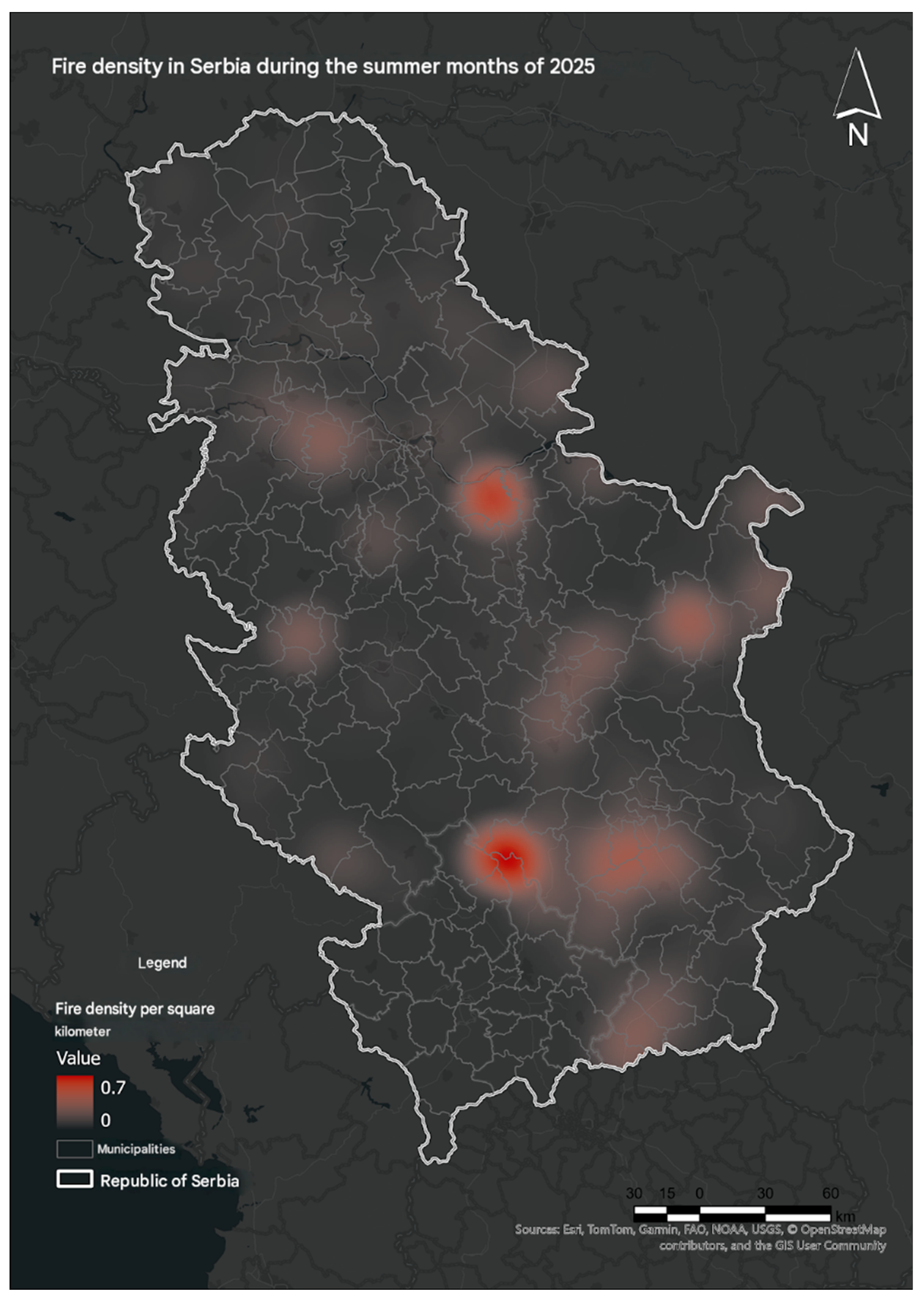
KDE converted the discrete FIRMS detections into a continuous concentration surface and revealed hotspot cores that extended beyond individual municipal boundaries. Two principal macro-cores reached the highest source index value of approximately 0.7. The southern core covered the Toplica-Pčinja area, particularly the connected territories of Kuršumlija, Žitorađa, and Podujevo. The second principal core was centered on Smederevo and the surrounding Danube agricultural environment.
Secondary, more diffuse concentrations appeared in eastern Serbia around Bor and in parts of western Serbia. Their lower intensity and broader spatial dispersion differentiated them from the compact southern and Smederevo cores. The density surface therefore confirmed that national fire pressure was concentrated in several geographically separated systems rather than evenly distributed across Serbia.
Figure 3.
Kernel density of retained active-fire detections in Serbia during June-August 2025, using a 10-km search radius. Source: NASA FIRMS (2025), processed by the authors in ArcGIS Pro.
Figure 3.
Kernel density of retained active-fire detections in Serbia during June-August 2025, using a 10-km search radius. Source: NASA FIRMS (2025), processed by the authors in ArcGIS Pro.
4.4. Municipal FRP Case Studies
4.4.1. Smederevo: Agricultural-Lowland Pattern
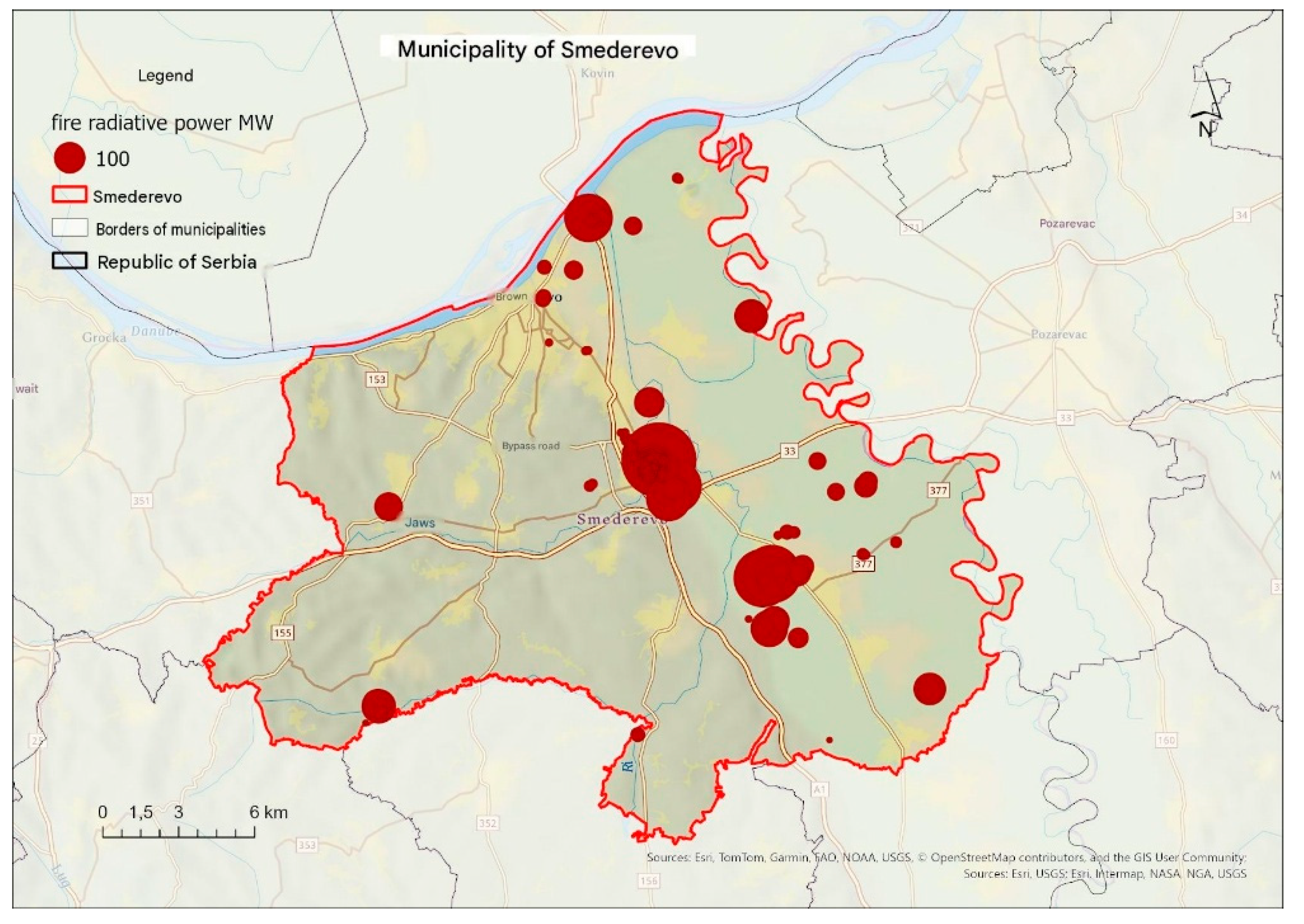
Smederevo combined a very high detection frequency with a predominantly dispersed agricultural-lowland pattern. The largest mapped FRP class reached approximately 100 MW. The densest grouping occurred south of the urban core and near the bypass axis, with additional smaller detections distributed through the rural sectors of Ralja and Radinac and along transport corridors.
The concentration of many moderate-energy detections across cultivated land is spatially consistent with recurring open burning and field-management activity, but the satellite layer does not verify the ignition source of individual points. The map therefore identifies a priority area for seasonal inspection and rapid local dispatch, not a causal attribution.
Figure 4.
Spatial distribution and fire radiative power of active-fire detections in Smederevo during summer 2025. Source: NASA FIRMS (2025), processed by the authors in ArcGIS Pro.
Figure 4.
Spatial distribution and fire radiative power of active-fire detections in Smederevo during summer 2025. Source: NASA FIRMS (2025), processed by the authors in ArcGIS Pro.
4.4.2. Podujevo: Mountain-Border Pattern
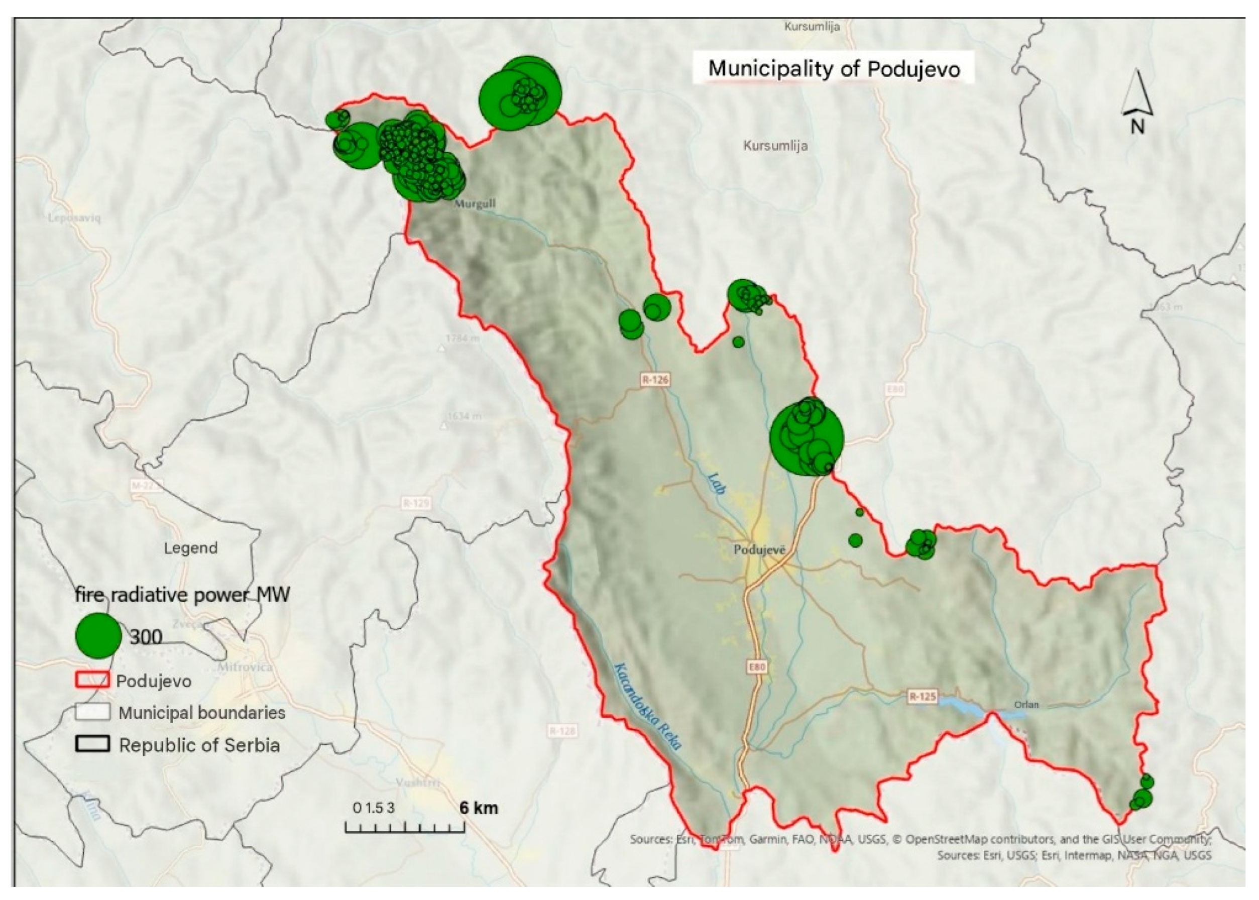
Podujevo displayed a more compact and higher-energy pattern, with the mapped FRP scale reaching approximately 300 MW. The strongest concentration appeared in the northern mountain sector near Murgula and the administrative boundary. Additional detections extended linearly along the R-126 corridor and in forest enclaves east of the principal transport axis.
Compared with Smederevo, the larger symbols and tighter border cluster indicate a different operational environment: fire activity was concentrated in mountain terrain where forest fuel continuity and access constraints may have increased suppression difficulty. These mechanisms remain interpretive because fuel load, slope, wind, and response time were not modeled directly.
Figure 5.
Spatial distribution and fire radiative power of active-fire detections in Podujevo during summer 2025. Source: NASA FIRMS (2025), processed by the authors in ArcGIS Pro.
Figure 5.
Spatial distribution and fire radiative power of active-fire detections in Podujevo during summer 2025. Source: NASA FIRMS (2025), processed by the authors in ArcGIS Pro.
4.4.3. Kuršumlija: Extreme High-Energy Mountain Pattern
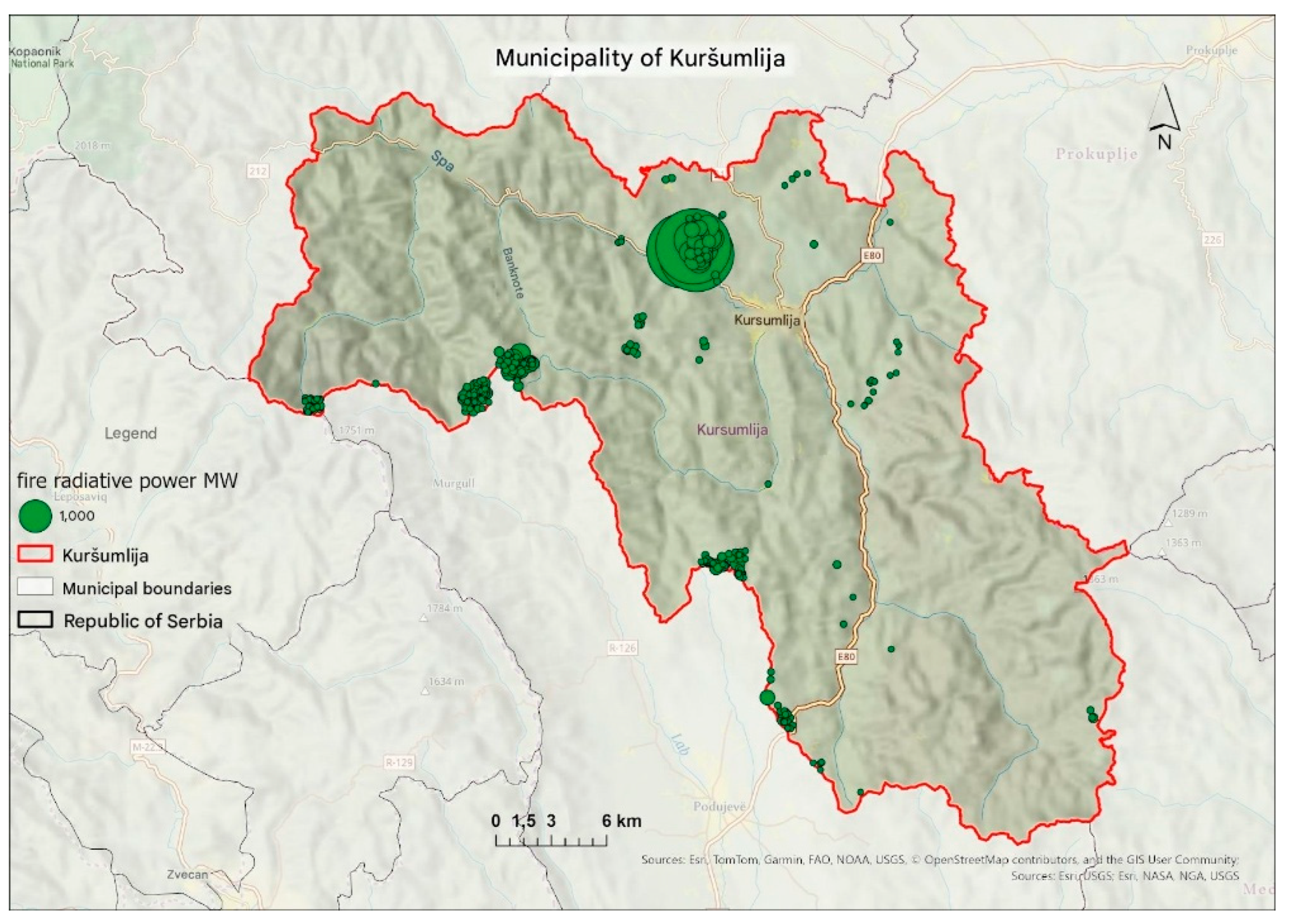
Kuršumlija contained the most extreme individual mapped FRP scale among the selected municipalities, reaching approximately 1,000 MW. The principal high-energy grouping lay northwest of the urban settlement in the central-northern forest hinterland. A secondary series occurred in the south near the administrative line toward Podujevo and along hilly-mountain ridges.
The coexistence of a central-northern high-energy cluster and a southern linear-border cluster indicates both localized and cross-boundary operational challenges. The map supports continuous satellite surveillance and accessibility analysis in the forested hinterland, while not establishing the duration or cause of each detected event.
Figure 6.
Spatial distribution and fire radiative power of active-fire detections in Kuršumlija during summer 2025. Source: NASA FIRMS (2025), processed by the authors in ArcGIS Pro.
Figure 6.
Spatial distribution and fire radiative power of active-fire detections in Kuršumlija during summer 2025. Source: NASA FIRMS (2025), processed by the authors in ArcGIS Pro.
4.4.4. Bor: Mixed Industrial-Natural Pattern
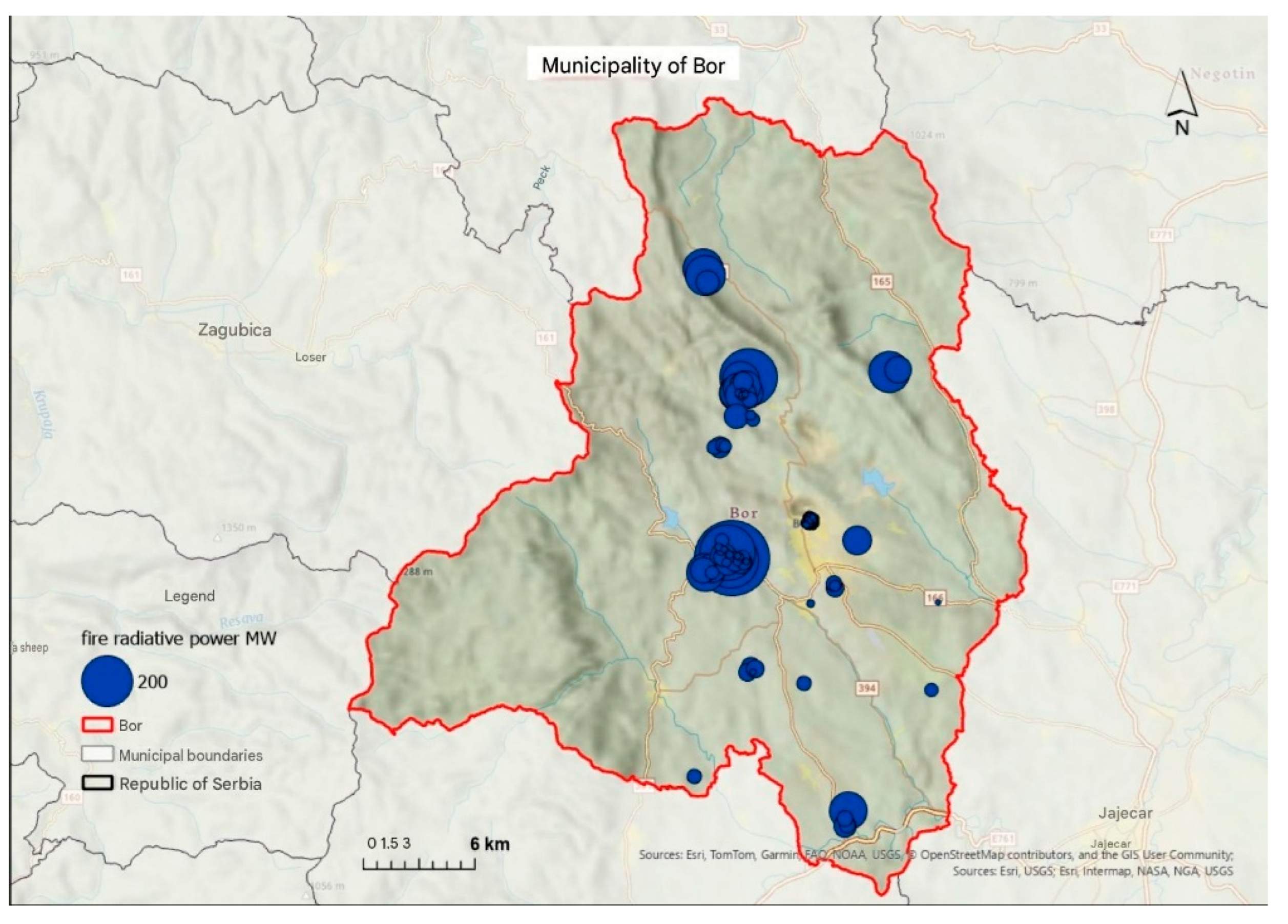
Bor showed a polycentric configuration with FRP values up to approximately 200 MW. The densest grouping occurred immediately south and southwest of the urban area near mining-industrial land and supporting infrastructure. A second concentration appeared in the central-northern mountain sector, while smaller detections followed eastern and southern rural and road corridors.
This pattern differs from both the agricultural dispersion of Smederevo and the compact border-mountain clusters of Podujevo and Kuršumlija. Because thermal products can also detect non-wildfire heat sources, the central industrial cluster requires comparison with industrial-source inventories and verified incident logs before it is interpreted as open-space fire activity.
Figure 7.
Spatial distribution and fire radiative power of active-fire detections in Bor during summer 2025. Source: NASA FIRMS (2025), processed by the authors in ArcGIS Pro.
Figure 7.
Spatial distribution and fire radiative power of active-fire detections in Bor during summer 2025. Source: NASA FIRMS (2025), processed by the authors in ArcGIS Pro.
4.5. Municipal Burned-Area Case Studies
4.5.1. Žitorađa: Connected Southern Burn Scar
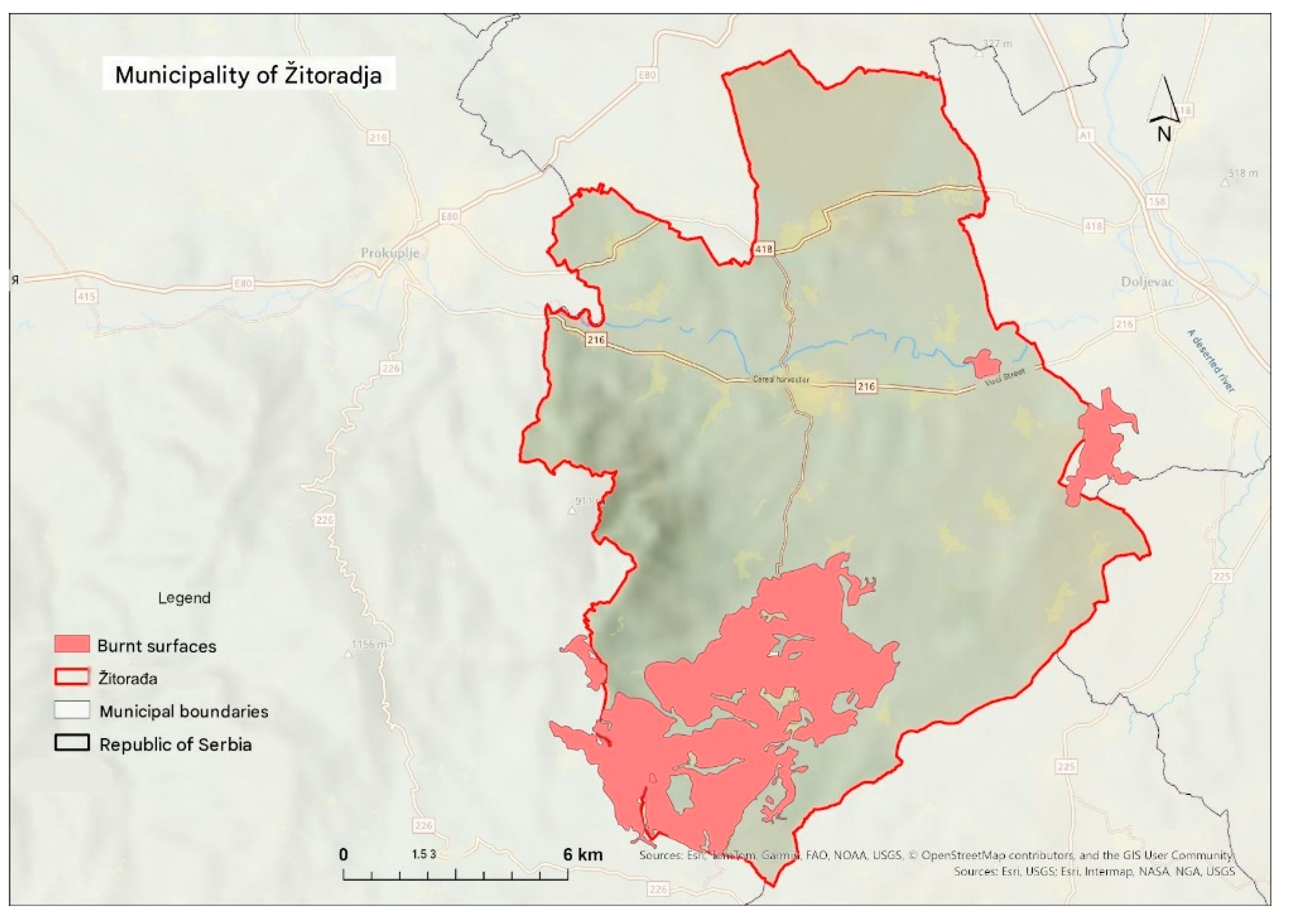
Žitorađa contained a dominant, connected burned-area feature in the far south and southeast, accompanied by smaller polygons along the eastern municipal edge and near valley and local-road corridors. The geometry distinguishes a major contiguous zone of land-cover damage from scattered peripheral features.
The southern polygon connects the municipal pattern to the wider Toplica hotspot and indicates that recovery planning should consider landscape continuity beyond the administrative boundary. Smaller eastern polygons require more localized investigation of land cover, access, and verified ignition records.
Figure 8.
EFFIS mapped burned-area polygons in Žitorađa during summer 2025. Source: EFFIS (2025), processed by the authors in ArcGIS Pro.
Figure 8.
EFFIS mapped burned-area polygons in Žitorađa during summer 2025. Source: EFFIS (2025), processed by the authors in ArcGIS Pro.
4.5.2. Kuršumlija: Border, Central, and Eastern Burned Areas
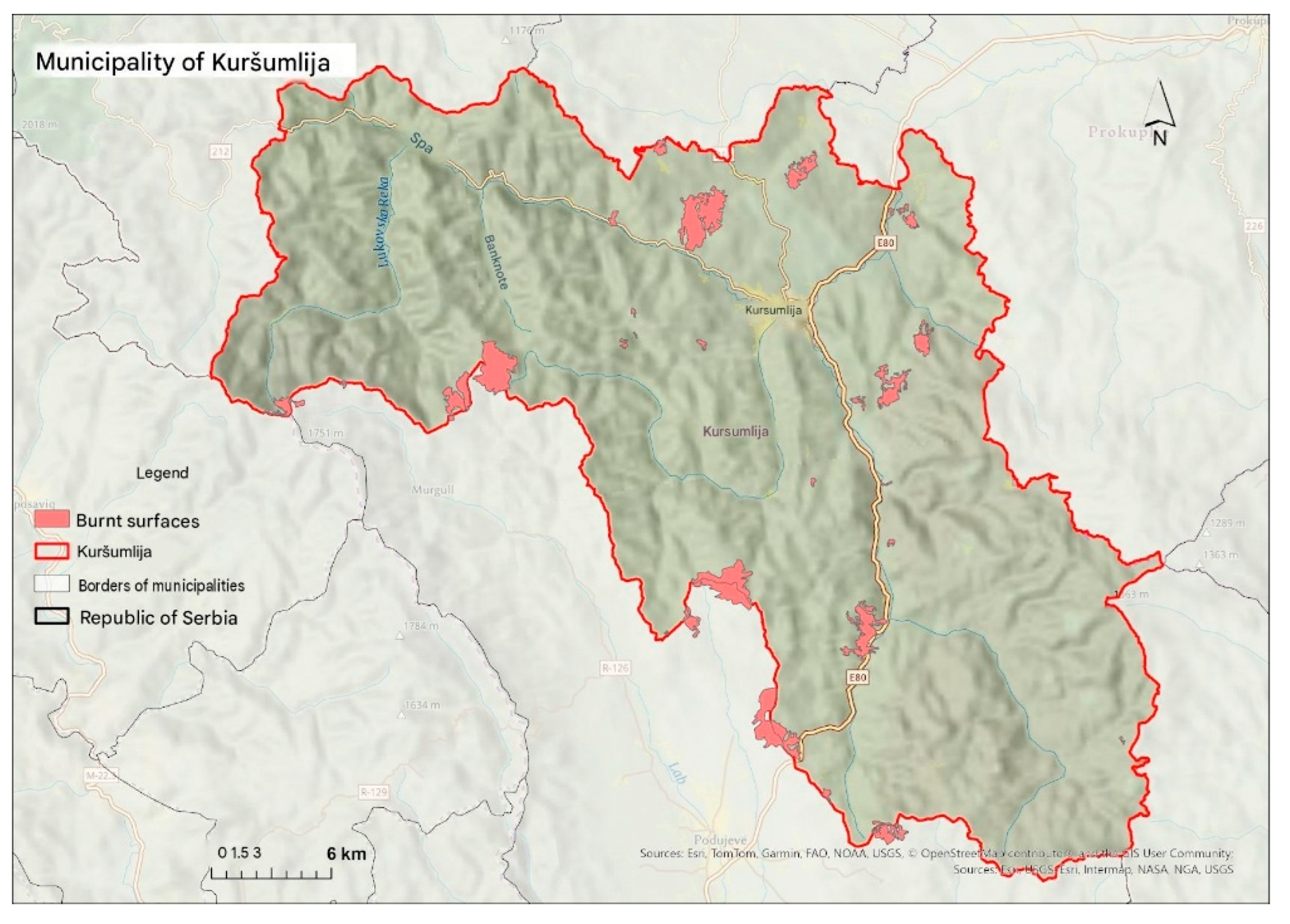
Kuršumlija combined three spatial components: dense and compact southern polygons along the administrative line toward Podujevo; isolated medium-sized polygons northwest of the urban settlement near the Toplica and Lukovska river hinterland; and smaller, linear or fragmented polygons along eastern valleys and access routes.
This arrangement shows that the municipality experienced both large connected damage in difficult terrain and dispersed burn scars closer to infrastructure. The mixture of geometries is consistent with multiple fire environments and supports separate priorities for cross-boundary suppression planning, road access, and ecological restoration.
Figure 9.
EFFIS mapped burned-area polygons in Kuršumlija during summer 2025. Source: EFFIS (2025), processed by the authors in ArcGIS Pro.
Figure 9.
EFFIS mapped burned-area polygons in Kuršumlija during summer 2025. Source: EFFIS (2025), processed by the authors in ArcGIS Pro.
4.5.3. Preševo: Eastern Border-Mountain Devastation
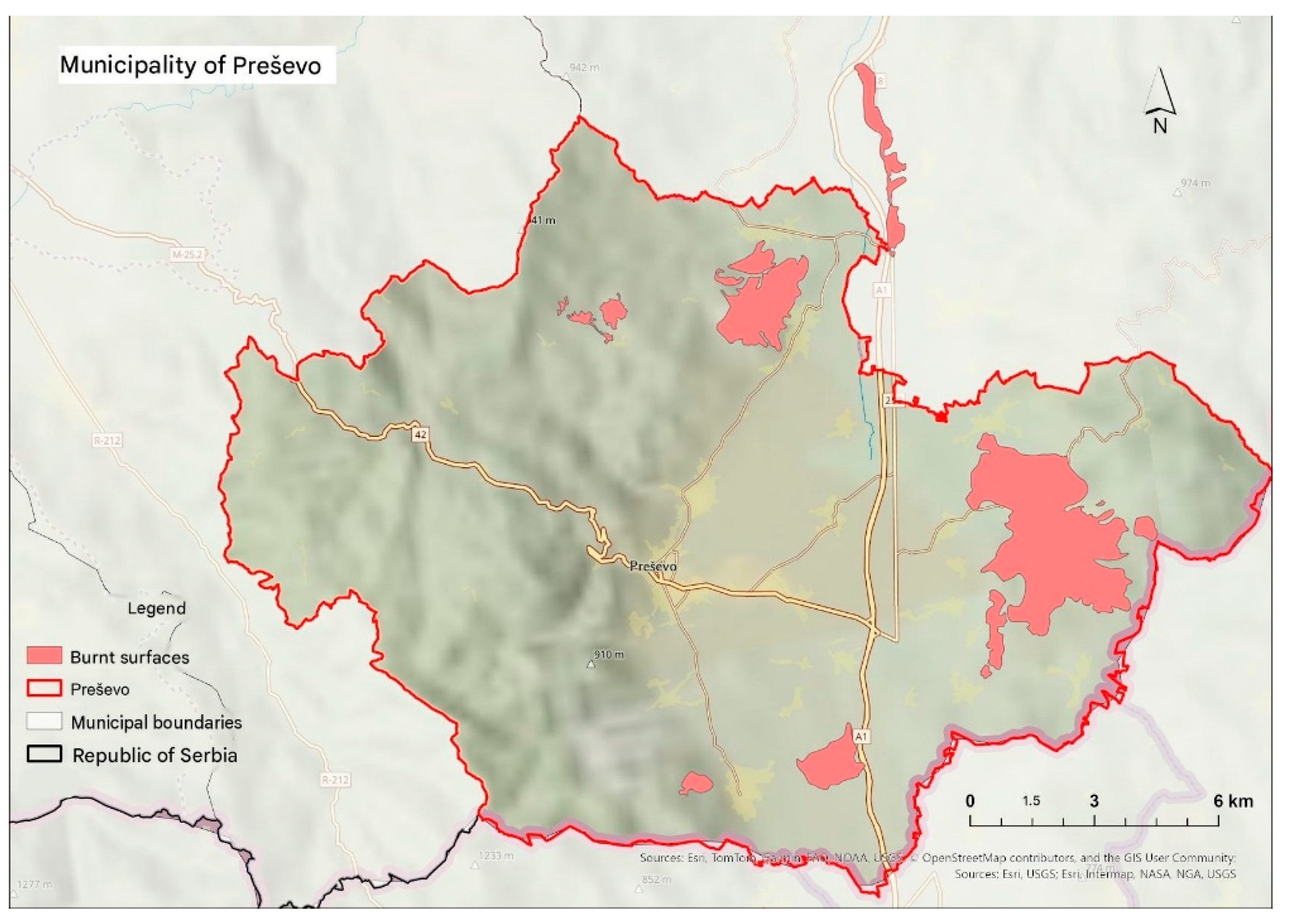
Preševo displayed its largest continuous burned-area polygon in the eastern hilly-mountain belt toward the state border. Several additional polygons occurred north of the urban settlement, while smaller southeastern and infrastructure-adjacent features appeared near the A1/E-75 corridor.
The large eastern polygon indicates extensive connected land-cover damage, whereas the northern and corridor features show a more fragmented component. Together, these features support cross-border information exchange, targeted access planning, and restoration assessment, but they do not, by themselves, identify the fire-spread mechanism or ignition source.
Figure 10.
EFFIS mapped burned-area polygons in Preševo during summer 2025—source: EFFIS (2025), processed by the authors in ArcGIS Pro.
Figure 10.
EFFIS mapped burned-area polygons in Preševo during summer 2025—source: EFFIS (2025), processed by the authors in ArcGIS Pro.
4.5.4. Leskovac: Fragmented Peripheral Mosaic
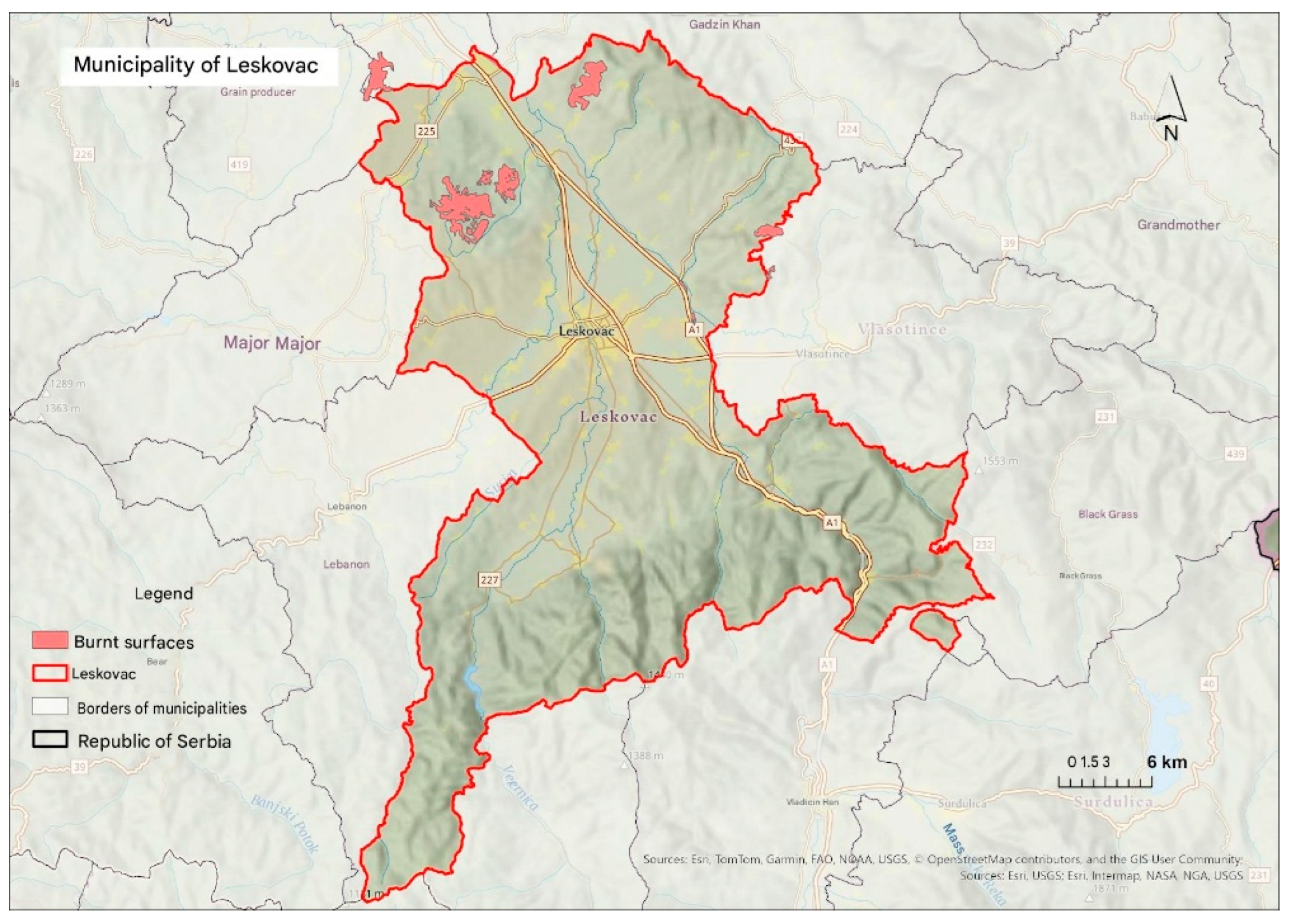
Leskovac showed the most fragmented burned-area mosaic among the four cases. The densest grouping of smaller and medium-sized polygons lay in the northwest toward Bojnik, with elongated features on the northern boundary toward Žitorađa and Gadžin Han. Additional smaller polygons occurred along the eastern and southeastern margins near Vlasotince, Crna Trava, and parts of the A1 corridor.
Unlike the dominant continuous polygons in parts of Preševo and Žitorađa, Leskovac’s spatial signature indicates numerous separate or sequential burned zones. This geometry increases the importance of rural surveillance, intermunicipal information exchange, and distributed access rather than concentrating restoration and response resources in only one location.
Figure 11.
EFFIS mapped burned-area polygons in Leskovac during summer 2025. Source: EFFIS (2025), processed by the authors in ArcGIS Pro.
Figure 11.
EFFIS mapped burned-area polygons in Leskovac during summer 2025. Source: EFFIS (2025), processed by the authors in ArcGIS Pro.
4.6. Comparative FRP Synthesis
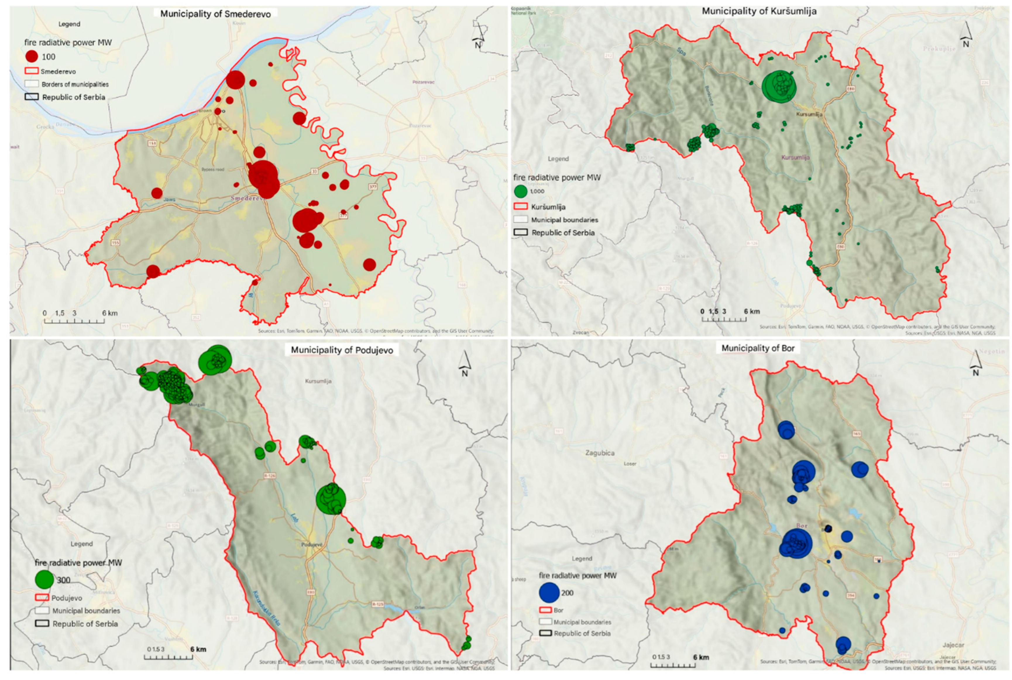
The four-panel FRP comparison confirms three contrasting spatial-intensity types. Smederevo represents frequent, dispersed, mostly moderate-energy detections in an agricultural-lowland setting. Podujevo and Kuršumlija form a border-mountain forest type, with compact clusters and higher maximum FRP, including the extreme scale in Kuršumlija. Bor represents a mixed technogenic-natural setting with an urban-industrial core, mountain detections, and peripheral road-linked activity.
The comparative map shows why municipal prevention cannot use a single operational template. Agricultural inspection and rapid field response are most relevant to Smederevo; satellite early warning, access analysis, and cross-boundary coordination are most relevant to the southern mountain cases; and industrial-source screening must be added in Bor.
Figure 12.
Comparative distribution and fire radiative power of active-fire detections in Smederevo, Podujevo, Kuršumlija, and Bor. Source: NASA FIRMS (2025), processed by the authors in ArcGIS Pro.
Figure 12.
Comparative distribution and fire radiative power of active-fire detections in Smederevo, Podujevo, Kuršumlija, and Bor. Source: NASA FIRMS (2025), processed by the authors in ArcGIS Pro.
4.7. Comparative Burned-Area Synthesis
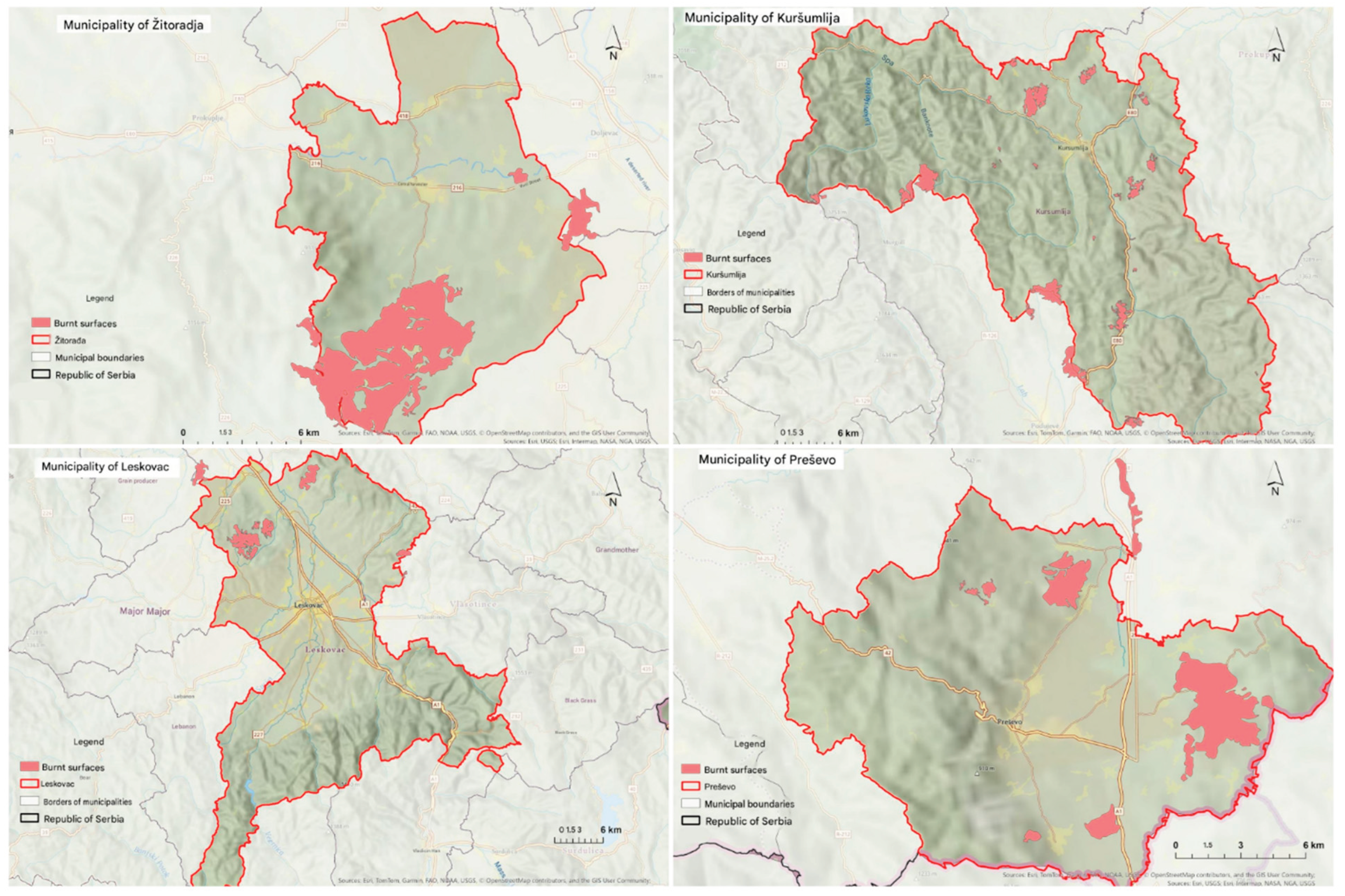
The four-panel EFFIS comparison regionalizes the largest mapped land-cover damage in southern and southeastern Serbia. Preševo and Kuršumlija contain large, relatively continuous border-mountain polygons; Leskovac displays a dense but fragmented northwestern and northern mosaic; and Žitorađa combines a major southern polygon with smaller elongated features toward eastern corridors.
These shapes add operational information beyond municipal totals. Continuous polygons identify broad restoration and erosion-control zones, while fragmented patterns call for distributed field verification and multiple local restoration sites. Their alignment with administrative boundaries also shows where damage assessment and recovery require intermunicipal or cross-border coordination.
Figure 13.
Comparative geometry of EFFIS mapped burned-area polygons in Žitorađa, Kuršumlija, Leskovac, and Preševo during summer 2025. Source: EFFIS (2025), processed by the authors in ArcGIS Pro.
Figure 13.
Comparative geometry of EFFIS mapped burned-area polygons in Žitorađa, Kuršumlija, Leskovac, and Preševo during summer 2025. Source: EFFIS (2025), processed by the authors in ArcGIS Pro.
4.8. Synthesis of Spatial Fire-Hazard Types
To synthesize the national and municipal patterns identified through active-fire frequency, kernel density, FRP, and burned-area geometry, the observed spatial configurations were grouped into three principal interpretive fire-hazard types (Table 2). The typology distinguishes an agricultural-lowland pattern, characterized by frequent but spatially dispersed detections and generally lower FRP values; a mountain-forest pattern, associated with compact or border-linked hotspots, higher-energy detections, and larger or more continuous burned-area polygons; and a mixed industrial-natural pattern, in which urban-industrial thermal clusters coexist with fire activity in surrounding mountain and forest environments. These types do not represent verified ignition mechanisms or mutually exclusive causal categories. Rather, they provide an operational synthesis of the dominant spatial signatures observed during the 2025 fire season and indicate why prevention, monitoring, accessibility planning, and response strategies should be adapted to different territorial settings.
5. Discussion
5.1. Main Findings and Scientific Interpretation
The integrated analysis demonstrated that the summer 2025 fire pattern in Serbia cannot be represented adequately by a single indicator. FIRMS frequency identified municipalities with repeated thermal activity; FRP differentiated the radiative intensity of those detections; KDE exposed cross-boundary concentration cores; and EFFIS polygons represented the spatial footprint of mapped land-cover damage. The strongest analytical result was therefore not simply the location of high values, but the mismatch and complementarity among these measures.
The national pattern broadly agreed with earlier research that identified southern and eastern Serbia as recurrently vulnerable during adverse summer conditions (Tošić et al., 2019; Lukić et al., 2017). The 2025 dataset added event-specific detail by isolating a southern macro-core spanning Toplica-Pčinja territories and by distinguishing it from the separate Smederevo concentration. The south was characterized by high-energy local cases and larger or connected burned-area features, while Smederevo combined high detection frequency with a predominantly agricultural spatial pattern. These observations refine a simple north-south risk narrative: elevated activity appeared in multiple landscapes, but its meaning differed by terrain and land use.
The results also complement GIS-based susceptibility research in Serbia. Multi-criteria susceptibility mapping identifies territories in which combinations of environmental and anthropogenic conditions may favor fire occurrence (Novković et al., 2021). The present analysis instead described where satellite evidence was concentrated during a specific season. Susceptibility and observed activity should not be treated as interchangeable, but comparison between them can strengthen future validation. Areas that are both structurally susceptible and repeatedly active warrant particular attention in preparedness planning.
5.2. Explanatory Context and Alternative Interpretations
The agricultural-lowland pattern is consistent with an anthropogenic context in which open burning, field management, and transport access can generate numerous spatially dispersed thermal anomalies. This interpretation is plausible for Smederevo because the point pattern follows an intensively used lowland landscape and contains many detections without the extreme FRP scale observed in Kuršumlija. Nevertheless, satellite data alone cannot identify the ignition source of an individual record. Industrial heat sources, false positives, repeated overpasses, and multiple observations of the same event must also be considered. The typology therefore describes spatial evidence and operational hypotheses, not verified causes.
The mountain-forest pattern combined high local FRP, compact hotspot groupings, and large or connected burned-area polygons. Dense or dehydrated woody biomass can sustain higher-energy fire behavior, while steep or inaccessible terrain can delay ground access and containment. Earlier Serbian studies emphasized the relevance of vegetation, terrain, and meteorological variables to fire risk (Lukić et al., 2017; Tošić et al., 2019), and road-based wildfire research shows that proximity alone does not guarantee effective suppression access (Tout et al., 2024). Even so, the present study did not directly model biomass, slope, wind, temperature, soil moisture, or response time. These mechanisms remain well-founded interpretations that require explicit testing in future multivariable models.
Bor represented an important boundary case. Its central and peripheral clusters occurred near both mining-industrial land and forested mountain areas. Thermal-anomaly products can detect heat sources that are not wildfires, and industrial environments therefore require careful quality control. At the same time, the surrounding vegetation and mountain terrain are genuinely exposed to open-space fire. Integrating land-cover masks, industrial heat-source inventories, incident logs, and higher-resolution imagery would help separate persistent technogenic anomalies from fire events in future analyses.
5.3. Added Value of Integrating FIRMS and EFFIS
FIRMS and EFFIS answered different questions. FIRMS supported rapid identification of where and when satellites detected anomalous heat and how much radiative power was associated with a record (Davies et al., 2009). EFFIS supported post-event interpretation of the geometry and extent of burned land within a harmonized European information environment (San-Miguel-Ayanz et al., 2012). The two products differed in spatial object, timing, sensor basis, and analytical purpose. Their integration therefore increased interpretive depth but did not convert one source into a direct validation of the other.
This complementarity was visible in the municipal comparisons. Smederevo’s high point frequency did not correspond to the same type of large, continuous burned-area pattern mapped in parts of southern Serbia. Conversely, Preševo and Žitorađa were prominent in the burned-area layer even though they were not the principal national examples in the highest FIRMS frequency class. Decision-makers relying only on point counts could overestimate recurring low-area activity relative to severe land-cover damage; decision-makers relying only on burn scars could overlook frequently recurring thermal events with implications for enforcement, air quality, and local response.
A practical integrated monitoring system should therefore preserve the distinction between detection, incident, intensity, and damage. An operational dashboard could display confidence-filtered active-fire points and FRP in near real time, then append validated incident records and EFFIS burn polygons as they become available. Such a structure would support both immediate response and post-season learning without collapsing heterogeneous evidence into a misleading single count.
5.4. Implications for Risk Reduction and Emergency Management
The differentiated spatial patterns imply differentiated interventions. In agricultural-lowland areas, prevention should emphasize seasonal communication, inspection, enforcement of open-burning restrictions, and rapid dispatch to recurring corridors. Because detections are dispersed, broad municipal coverage and local reporting may be more effective than concentrating resources at a small number of forest lookout points. Risk education should address the documented gap between general wildfire awareness and practical knowledge among younger populations (Cvetković et al., 2018).
In southern and southeastern mountain areas, early satellite warning should be combined with accessibility analysis. ArcGIS network models can identify travel-time constraints, alternative access routes, water points, and locations where fire roads or pre-positioned resources would reduce response delays. Large or border-linked burn polygons also show why municipal planning should not end at administrative boundaries. Shared geospatial layers, common symbology, interoperable data standards, and procedures for requesting aerial support would improve coordination across affected territories (Cvetković, 2025; Molnár, 2024).
For Bor and other mixed industrial-natural environments, fire monitoring should be integrated with industrial safety and land-restoration information. Persistent heat signatures require screening against known industrial sources, while peri-urban vegetation and degraded land around mining facilities require targeted prevention. This integrated framing is consistent with the holistic resilience approach to technological hazards developed by Cvetković et al. (2024).
At the national level, the results support moving from static annual summaries toward a reproducible seasonal geospatial workflow. The process could be institutionalized through scheduled FIRMS acquisition, confidence filtering, automated assignment to municipalities, KDE updates, alert thresholds, linkage with incident-management records, and post-fire reconciliation with EFFIS. Implementation should combine interoperable technology (Hanspal & Behera, 2024; Jovičić et al., 2024), community participation (Cvetković et al., 2025), inclusive warning design (Jevtić et al., 2025), and integrated institutional governance (Milenković, 2025).
Based on the spatial patterns identified in the 2025 dataset, Table 3 summarizes the principal recommendations for strengthening wildfire prevention, preparedness, response, and post-fire recovery in Serbia. The proposed measures are differentiated by the dominant fire-hazard environments identified in the analysis and emphasize integrating satellite monitoring, GIS-based decision support, local prevention, operational accessibility, interinstitutional coordination, and post-fire assessment.
5.5. Limitations
The study has several limitations. First, MODIS and VIIRS differ in nominal spatial resolution and overpass characteristics. Small, brief, obscured, or low-temperature fires may be missed, whereas a long-duration event may be detected more than once. The 5,233 FIRMS records must therefore not be read as 5,233 unique incidents. Second, confidence filtering reduces some uncertainty but does not eliminate false positives, particularly near industrial heat sources.
Third, EFFIS burned-area products and FIRMS active-fire points differ in timing and spatial representation. A direct one-to-one correspondence should not be expected. The reported EFFIS feature count also does not by itself indicate the total severity of ecological damage. Fourth, municipal aggregation introduces the modifiable areal unit problem and can conceal within-municipality clusters or split continuous fires across boundaries.
Fifth, the analysis covered one summer season. It could identify the geography of an important episode but could not determine whether the observed configurations were stable across years. Sixth, no independent meteorological dataset was incorporated, and no statistical climate-fire model was estimated. Heatwaves, drought, wind, and vegetation dryness are plausible contextual explanations supported by earlier studies, but the present results cannot confirm their magnitude or causal contribution. Finally, the archived thesis text did not preserve the exact ArcGIS Pro version, EPSG identifier, download timestamps, or complete geoprocessing log, which limits exact computational replication.
5.6. Directions for Future Research
Future work should extend the analysis across multiple fire seasons and combine detections with temperature, precipitation, wind, soil moisture, vegetation, land cover, slope, road access, and verified ignition-source data. A spatiotemporal panel or event-based model could test which factors predict detection frequency, FRP, and burned-area extent while accounting for repeated observations and municipal differences. Linking satellite products to official incident identifiers would also permit evaluation of detection sensitivity and false-positive rates.
Higher-resolution Sentinel or commercial imagery could improve burn-scar delineation and distinguish agricultural plots from forest damage. Network analysis should quantify emergency access to southern mountain hotspots. At the same time, scenario modeling could evaluate where new fire roads, water points, cameras, or pre-positioned units would most reduce response time. Finally, the interpretive typology developed here should be tested against independent years and regions before being used as a formal classification system.
6. Conclusions
This study integrated 5,233 confidence-filtered NASA FIRMS active-fire detections and 269 EFFIS burned-area features to characterize the spatial structure of open-space fires in Serbia during June-August 2025. The analysis showed pronounced national heterogeneity. High active-fire frequency occurred in Smederevo, Bor, Kuršumlija, and Podujevo. At the same time, the strongest mapped burned-area values were concentrated mainly in southern and southeastern municipalities, including Žitorađa, Kuršumlija, Preševo, and Leskovac. KDE further isolated a major southern concentration and a separate agricultural core around Smederevo.
The principal scientific contribution is the integrated interpretation of detection frequency, continuous density, FRP, and burned-area geometry. This combination distinguished a dispersed agricultural-lowland pattern, a high-energy mountain-forest pattern, and a mixed industrial-natural pattern. The typology helps explain why a single national indicator cannot represent both recurring thermal activity and severe land-cover damage.
The findings support differentiated prevention and response: inspection and rapid local intervention in agricultural zones; satellite early warning, accessibility modeling, and cross-boundary coordination in mountain areas; and integrated industrial and vegetation monitoring around Bor. The results should nevertheless be interpreted within the limits of satellite resolution, repeated detections, administrative aggregation, a single-season design, and the absence of a direct meteorological model. Future multiyear, multivariable research should test the stability and drivers of the mapped patterns. Integrating near-real-time detection with post-fire damage mapping offers a practical foundation for more spatially targeted wildfire risk reduction in Serbia.
Author Contributions
Conceptualization, A.P. and T.L.; methodology, A.P. and T.L.; software, formal analysis, investigation, data curation, and visualization, A.P.; validation, T.L. and V.M.C.; literature review and risk-management interpretation, V.M.C.; writing-original draft preparation, A.P.; writing-review and editing, T.L. and V.M.C.; supervision, T.L. All authors have read and agreed to the published version of the manuscript.
Funding
This research received no external funding.
Institutional Review Board Statement
Not applicable. The study used publicly accessible geospatial and documentary data and involved no human participants or animals.
Informed Consent Statement
Not applicable.
Data Availability Statement
The source datasets are publicly accessible through NASA FIRMS and the European Forest Fire Information System. The processed municipal layers and ArcGIS Pro workflow are available from the corresponding author on reasonable request.
Acknowledgments
This article was developed from Aleksandar Prodanov’s master’s thesis, Application of GIS in Wildfire Analysis in Serbia During the Summer of 2025, prepared at the Department of Geography, Tourism and Hotel Management, Faculty of Sciences, University of Novi Sad, under the supervision of Tin Lukić. The authors acknowledge NASA FIRMS, EFFIS, and the Republic Geodetic Authority for access to geospatial data.
Conflicts of Interest
The authors declare no conflict of interest.
References
- Ahmed, N.; Islam, M. S. COSI-SAFE: A GIS-based multi-criteria framework for evaluating urban open space suitability for post-earthquake emergency sheltering. Int. J. Disaster Risk Manag. 2025, 7(2), 169–192. [Google Scholar] [CrossRef]
- Akinwale, O. M.; Adongo, M. A. O.; Nasir, S.; Akinwale, O. M.; Sanni, F. O. The impact of Geographic Information Systems on emergency management and disaster response in Nigeria. Int. J. Disaster Risk Manag. 2025, 7(2), 501–516. [Google Scholar] [CrossRef]
- Aniñon, M. J. C.; Oreta, A. W. C. Site suitability of evacuation centers in Zamboanga City, Philippines using GIS: Assessing safety and accessibility in hazard-prone areas. Int. J. Disaster Risk Manag. 2026, 8(1), 103–130. [Google Scholar] [CrossRef]
- Beli, A.; Renner, R.; Cvetković, V. M.; Ivanov, A.; Gačić, J. A cross-national study of disaster risk management: Strengths and weaknesses in Bulgaria, Romania, and Albania with reflections on Serbia. Int. J. Disaster Risk Manag. 2025, 7(1), 431–460. [Google Scholar] [CrossRef]
- Canete, R.; Biñas, R. Differential risk and the elements of resilience: A framework for advancing disaster risk reduction. Int. J. Disaster Risk Manag. 2025, 7(2), 209–238. [Google Scholar] [CrossRef]
- Cvetković, V. M. A predictive model of community disaster resilience based on social identity influences (MODERSI). Int. J. Disaster Risk Manag. 2023, 5(2), 57–80. [Google Scholar] [CrossRef]
- Cvetković, V. M. First responders in the Western Balkans: Strengthening capacities and preparedness for a resilient future. Int. J. Disaster Risk Manag. 2025, 7(2), 361–384. [Google Scholar] [CrossRef]
- Cvetković, V. M.; Aleksova, B.; Renner, R.; Gačić, J.; Ivanov, A.; Milašinović, S. Community-based disaster risk reduction: Overcoming barriers to build stronger communities. Int. J. Disaster Risk Manag. 2025, 7(2), 113–130. [Google Scholar] [CrossRef]
- Cvetković, V. M.; Milenković, D.; Bašić, J.; Lukić, T.; Renner, R. Predictive model of community disaster resilience across Serbia: A BRIC-DROP composite index and spatial patterns. Safety 2026, 12(3), 59. [Google Scholar] [CrossRef]
- Cvetković, V. M.; Milenković, D.; Lukić, T. Measuring community disaster resilience in Serbia using an adapted BRIC framework grounded in DROP: Index construction and regional disparities. Geosciences 2026, 16(4), 135. [Google Scholar] [CrossRef]
- Cvetković, V. M.; Milenković, D.; Lukić, T.; Renner, R. Theoretical evolution of measuring community resilience to natural and technological disasters: Past, present, and future-empirical insights from qualitative research in Serbia. Open Geosci. 2026, 18(1), 20250968. [Google Scholar] [CrossRef]
- Cvetković, V.; Nikolić, M. Uloga društvenih mreža u smanjenju rizika od katastrofa: Studija slučaja Beograd [The role of social networks in disaster risk reduction: A case study of Belgrade]. Bezbednost 2021, 63(3), 25–42. [Google Scholar] [CrossRef]
- Cvetković, V.; Protić, D.; Stefanović, D. Integrisano smanjenje rizika od katastrofa izazvanih požarima: Pregled literature [Integrated disaster risk reduction from fire hazards: A literature review]. Dipl. I Bezb. 2023, 6(2), 11–70. [Google Scholar]
- Cvetković, V. M.; Renner, R.; Jakovljević, V. Industrial disasters and hazards: From causes to consequences-a holistic approach to resilience. Int. J. Disaster Risk Manag. 2024, 6(2), 149–168. [Google Scholar] [CrossRef]
- Cvetković, V. M.; Roder, G.; Öcal, A.; Filipović, M.; Janković, B.; Noji, E. Knowledge of children and youth about forest fires: Discrepancies between basic perception and reality. Vojn. Delo 2018, 70(1), 171–185. [Google Scholar] [CrossRef]
- Cvetković, V. M.; Romanić, S.; Beriša, H. Religion influence on disaster risk reduction: A case study of Serbia. Int. J. Disaster Risk Manag. 2023, 5(1), 66–81. [Google Scholar] [CrossRef]
- Cvetković, V. M.; Šišović, V. Understanding the sustainable development of community (social) disaster resilience in Serbia: Demographic and socio-economic impacts. Sustainability 2024, 16(7), 2620. [Google Scholar] [CrossRef]
- Davies, D. K.; Ilavajhala, S.; Wong, M. M.; Justice, C. O. Fire Information for Resource Management System: Archiving and distributing MODIS active fire data. IEEE Trans. Geosci. Remote Sens. 2009, 47(12), 3956–3964. [Google Scholar] [CrossRef]
- Elkheir, A. Z.; Abdelhamid, M.; Laaboudi, M.; Achebour, A.; Sahil, M.; Elyagoubi, S.; Melhaoui, M. Advanced flood risk mapping in Bouarfa Watershed using integrated machine learning, GIS, and MCDM. Int. J. Disaster Risk Manag. 2025, 7(2), 1–20. [Google Scholar] [CrossRef]
- European Forest Fire Information System. EFFIS current situation viewer and rapid damage assessment. European Commission, Joint Research Center. 2025. Available online: https://effis.emergency.copernicus.eu/.
- Hanspal, M. S.; Behera, B. Role of emerging technology in disaster management in India: An overview. Int. J. Disaster Risk Manag. 2024, 6(2), 133–148. [Google Scholar] [CrossRef]
- Janković, L.; Cvetković, V. M.; Gačić, J.; Renner, R.; Jakovljević, V. Integrating psychosocial support into emergency and disaster management and public safety: The role of the Red Cross of Serbia. Int. J. Contemp. Secur. Stud. 2025, 1(1), 99–124. [Google Scholar] [CrossRef]
- Jevtić, M.; Cvetković, V. M.; Gačić, J.; Raonić, Z. Factors of vulnerability and resilience of persons with disabilities during disasters: Challenges and strategies for inclusive risk reduction. Int. J. Disaster Risk Manag. 2025, 7(1), 91–114. [Google Scholar] [CrossRef]
- Joshi, K. D.; Poudel, D. K. Transforming landscapes, shaping risk: Land cover change and disaster vulnerability in Parshuram Municipality (2005-2025). Int. J. Disaster Risk Manag. 2025, 7(2), 551–564. [Google Scholar] [CrossRef]
- Jovičić, R.; Gostimirović, L.; Milašinović, S. Use of new technologies in the field of protection and rescue during disasters. Int. J. Disaster Risk Manag. 2024, 6(2), 111–122. [Google Scholar] [CrossRef]
- Krnjić, I.; Cvetković, V. Investigating students’ attitudes and preferences towards disaster learning multimedia to enhance preparedness. Bull. Serbian Geogr. Soc. 2021, 101(2), 79–96. [Google Scholar] [CrossRef]
- Lazić, Ž.; Đujić, K.; Milašinović, M. Fire protection of religious buildings in Serbia: Challenges, risks, and improvement measures. Int. J. Disaster Risk Manag. 2026, 8(1), 293–304. [Google Scholar] [CrossRef]
- Lukić, T.; Marić, P.; Hrnjak, I.; Gavrilov, M. B.; Mlađan, D.; Zorn, M.; Komac, B.; Milošević, Z.; Marković, S. B.; Sakulski, D.; Jordaan, A.; Đorđević, J.; Pavić, D.; Stojsavljević, R. Forest fire analysis and classification based on a Serbian case study. Acta Geogr. Slov. 2017, 57(1), 51–63. [Google Scholar] [CrossRef]
- Mančić, T. Climate change as a security challenge, risk and threat of the 21st century and its consequences on critical infrastructure. Int. J. Contemp. Secur. Stud. 2025, 1(1), 191–204. [Google Scholar] [CrossRef]
- Milenković, D. Theoretical, institutional and organizational aspects of the integrated disaster risk reduction system: Towards a deeper understanding of disaster resilience in Serbia. Int. J. Contemp. Secur. Stud. 2025, 1(1), 175–190. [Google Scholar] [CrossRef]
- Milenković, D.; Cvetković, V. M. Rethinking disaster resilience: Conceptual framework, core dimensions, and key actors. Int. J. Disaster Risk Manag. 2025, 7(2), 455–468. [Google Scholar] [CrossRef]
- Mokhele, M. O. Centres or units: Making sense of decentralisation of disaster management in South African municipalities. Int. J. Disaster Risk Manag. 2024, 6(2), 19–38. [Google Scholar] [CrossRef]
- Molnár, A. A systematic collaboration of volunteer and professional fire units in Hungary. Int. J. Disaster Risk Manag. 2024, 6(1), 1–13. [Google Scholar] [CrossRef]
- NASA Fire Information for Resource Management System. FIRMS active-fire data. NASA Earthdata. 2025. Available online: https://firms.modaps.eosdis.nasa.gov/.
- Nikolić, N.; Cvetković, V. M.; Renner, R.; Cvijović, N.; Gačić, J. Disaster risk perception and local resilience near the “Duboko” landfill: Challenges of governance, management, trust, and environmental communication in Serbia. Open Geosci. 2025, 17(1), 20250850. [Google Scholar] [CrossRef]
- Nilsen, A. A.; Størdal, T. R.; Johansen, V.; Ronge, J. L.; Grytting, E. Beyond platform type: Effects of vegetation density, sensor modality, and search strategy on aerial search and rescue performance. Int. J. Disaster Risk Manag. 2026, 8(1), 511–538. [Google Scholar] [CrossRef]
- Novković, I.; Marković, G. B.; Lukić, Đ.; Dragićević, S.; Milošević, M. V.; Đurđić, S.; Samardžić, I.; Ležaić, T.; Tadić, M. GIS-based forest fire susceptibility zonation with IoT sensor network support: case study-Nature Park Golija, Serbia. Sensors 2021, 21(19), 6520. [Google Scholar] [CrossRef] [PubMed]
- Ocal, F. E.; Torun, S. Leveraging artificial intelligence for enhanced disaster response coordination. Int. J. Disaster Risk Manag. 2025, 7(1), 235–246. [Google Scholar] [CrossRef]
- Pandya, V. V. A comparative analysis of federal emergency management systems: Evidence from the United States, Canada, Japan, Germany, and Australia. Int. J. Disaster Risk Manag. 2025, 7(2), 153–168. [Google Scholar] [CrossRef]
- Pimentel, M. A. R.; Azuelo, A. W. C. Operational capabilities in disaster emergency management of Bureau of Fire Protection personnel in Camarines Norte, Philippines. Int. J. Disaster Risk Manag. 2026, 8(1), 239–256. [Google Scholar] [CrossRef]
- Rebouh, N.; Tout, F.; Dinar, H.; Benzid, Y.; Zouak, Z. Integrating multi-source geospatial data and AHP for flood susceptibility mapping in Ain Smara, Constantine, Algeria. Int. J. Disaster Risk Manag. 2024, 6(2), 245–264. [Google Scholar] [CrossRef]
- Republic Geodetic Authority. GeoSrbija: Register of spatial units and administrative boundaries of the Republic of Serbia. 2025. Available online: https://download.geosrbija.rs/.
- Roy, B. K.; Shawon, M. I. H.; Hasan, M. M. Community-driven risk assessment: Integrating local perceptions into quantifiable risk weights using Analytical Hierarchy Process (AHP)-Geographical Information System (GIS). Int. J. Disaster Risk Manag. 2025, 7(2), 131–152. [Google Scholar] [CrossRef]
- Sacyaten, C. S. Crisis communication in times of disasters: Public perceptions on the timeliness and clarity of safety announcements: A systematic literature review. Int. J. Disaster Risk Manag. 2025, 7(2), 193–208. [Google Scholar] [CrossRef]
- San-Miguel-Ayanz, J.; Schulte, E.; Schmuck, G.; Camia, A.; Strobl, P.; Liberta, G.; Giovando, C.; Boca, R.; Sedano, F.; Kempeneers, P.; McInerney, D.; Withmore, C.; Santos de Oliveira, S.; Rodrigues, M.; Durrant, T.; Corti, P.; Oehler, F.; Vilar, L.; Amatulli, G. Comprehensive monitoring of wildfires in Europe: The European Forest Fire Information System (EFFIS). In Approaches to Managing Disaster – Assessing Hazards, Emergencies and Disaster Impacts; Tiefenbacher, J., Ed.; InTech, 2012. [Google Scholar] [CrossRef] [PubMed]
- Tošić, I.; Mlađan, D.; Gavrilov, M. B.; Živanović, S.; Radaković, M. G.; Putniković, S.; Petrović, P.; Krstić Mistridželović, I.; Marković, S. B. Potential influence of meteorological variables on forest fire risk in Serbia during the period 2000-2017. Open Geosci. 2019, 11(1), 414–425. [Google Scholar] [CrossRef]
- Tout, F.; Rebouh, N.; Dinar, H.; Benzid, Y.; Zouak, Z. The contribution of roads to forest fire protection in Tamza Municipality, Northeast Algeria. Int. J. Disaster Risk Manag. 2024, 6(2), 39–50. [Google Scholar] [CrossRef]
- Yamah, D.; Folorunsho, T. Leveraging social media and mobile technology for disaster communication in Nigeria. Int. J. Disaster Risk Manag. 2026, 8(1), 1–30. [Google Scholar] [CrossRef]
Figure 1.
Number of retained active-fire detections by municipality in Serbia during June-August 2025. Source: NASA FIRMS (2025), processed by the authors in ArcGIS Pro.
Figure 1.
Number of retained active-fire detections by municipality in Serbia during June-August 2025. Source: NASA FIRMS (2025), processed by the authors in ArcGIS Pro.
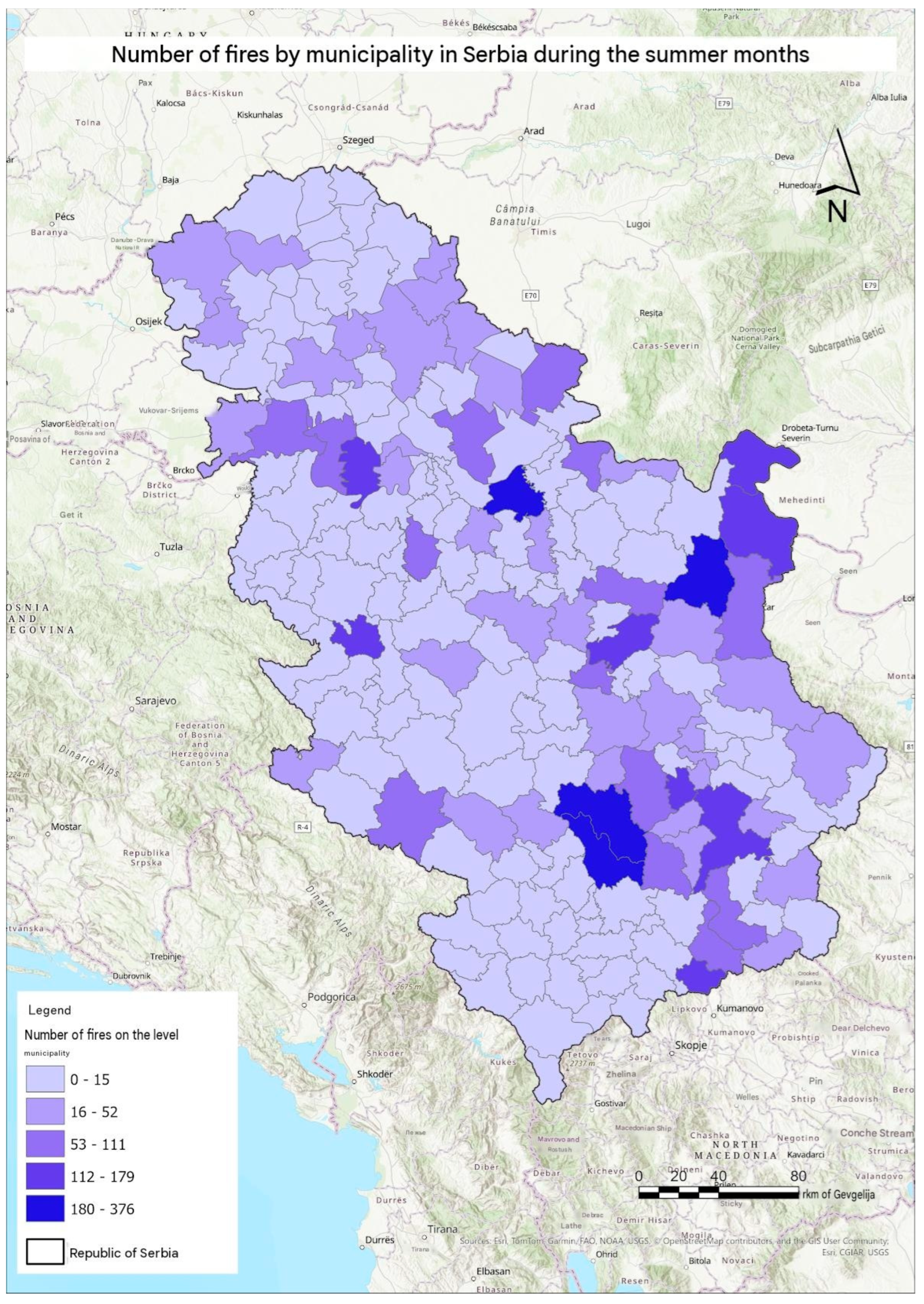
Figure 2.
Mapped burned-area values by municipality in Serbia during June-August 2025. Source: EFFIS (2025), processed by the authors in ArcGIS Pro.
Figure 2.
Mapped burned-area values by municipality in Serbia during June-August 2025. Source: EFFIS (2025), processed by the authors in ArcGIS Pro.
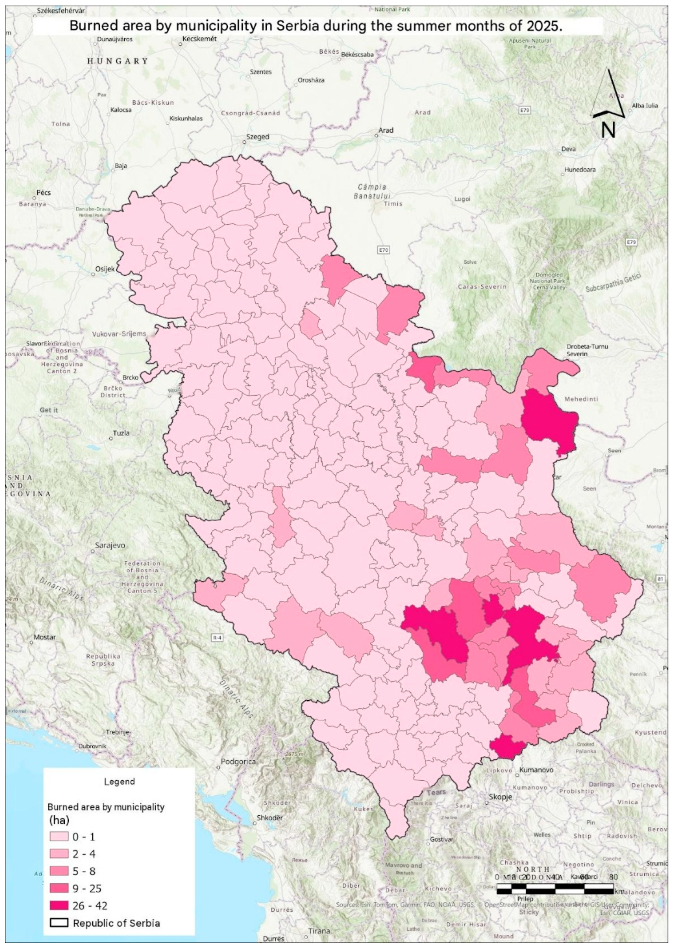
Table 2.
Interpretive typology of the principal spatial fire patterns identified in the 2025 dataset.
Table 2.
Interpretive typology of the principal spatial fire patterns identified in the 2025 dataset.
| Type | Representative areas | Observed spatial evidence | Operational relevance |
|---|---|---|---|
| Agricultural-lowland | Smederevo and the Danube agricultural zone | High detection frequency; dispersed points; FRP below the mountain-case maxima | Field surveillance; residue-burning enforcement; rapid local dispatch |
| Mountain-forest | Kuršumlija, Podujevo, Preševo, Žitorađa, and parts of Leskovac | Compact or border-linked hotspots; high FRP; larger or connected burn polygons | Satellite warning; access and fire-road models; aerial and intermunicipal coordination |
| Mixed industrial-natural | Bor and its mountain hinterland | Urban-industrial and mountain clusters; intermediate-to-high FRP; polycentric distribution | Integrated industrial, peri-urban, and forest monitoring |
Note: The typology is an interpretive synthesis of mapped frequency, FRP, density, and burned-area geometry. It is not a causal classification and does not assign a verified ignition source to individual detections.
Table 3.
Recommendations for strengthening wildfire risk reduction and fire-protection capacities in Serbia based on the spatial patterns identified in the 2025 dataset.
Table 3.
Recommendations for strengthening wildfire risk reduction and fire-protection capacities in Serbia based on the spatial patterns identified in the 2025 dataset.
| Strategic area | Identified need | Recommended measures | Priority spatial context | Expected operational benefit |
|---|---|---|---|---|
| Early detection and warning | Rapid identification of emerging fire activity | Establish systematic near-real-time monitoring of NASA FIRMS detections; define municipal alert thresholds based on confidence, FRP, and hotspot density; integrate subsequent EFFIS burn mapping. | National level, with priority to southern, southeastern, and eastern Serbia | Earlier detection, faster verification, and improved situational awareness |
| Agricultural-fire prevention | Numerous dispersed thermal detections in agricultural-lowland environments | Strengthen seasonal field inspections, enforcement of restrictions on open and residue burning, targeted public information campaigns, and rapid reporting mechanisms | Smederevo and the Danube agricultural zone | Reduction of preventable agricultural fires and faster local intervention |
| Mountain and forest surveillance | High-energy fires and compact or connected hotspot configurations | Increase satellite surveillance during high-risk periods; introduce lookout, camera, drone, and remote-sensing support where operationally feasible | Kuršumlija, Podujevo, Preševo, Žitorađa, and similar mountain areas | Earlier detection of fires in remote terrain and improved initial response |
| Emergency accessibility | Difficult access to fires in mountainous and forested terrain | Develop GIS-based road and travel-time models; map alternative access routes, fire roads, water points, and suitable locations for pre-positioned resources | Southern and southeastern mountain areas | Reduced response time and improved deployment of firefighting resources |
| Pre-positioning of resources | Concentration of high-energy activity in recurrent hotspot areas | Use historical FIRMS, KDE, FRP, and burned-area data to identify locations for temporary seasonal positioning of vehicles, crews, water tanks, and other response capacities | Recurrent hotspot municipalities | Faster initial attack and more efficient allocation of limited resources |
| Intermunicipal and cross-boundary coordination | Hotspots and burn scars extend across administrative boundaries | Establish shared geospatial layers, harmonized operational maps, common reporting procedures, interoperable communication, and predefined mutual-assistance arrangements | Toplica-Pčinja and other border-linked hotspot areas | Faster coordination and more effective management of fires crossing administrative boundaries |
| Aerial firefighting support | Large and high-energy fires may exceed local ground-response capacity | Define spatial and operational criteria for requesting helicopters or other aerial support and identify suitable water-supply and staging locations in advance | High-FRP mountain-forest environments | More timely escalation of suppression operations |
| Industrial-natural interface management | Potential coexistence of wildfire and persistent technogenic thermal sources | Cross-check satellite thermal anomalies against industrial heat-source inventories and verified incident records; integrate industrial safety and vegetation-management information | Bor and similar mining-industrial environments | Reduction of false alarms and better distinction between industrial heat signatures and open-space fires |
| Vegetation and fuel management | Potential continuity of combustible vegetation around recurrent hotspot zones | Prioritize vegetation management, fuel reduction, firebreak maintenance, and clearance around critical access routes and exposed infrastructure. | Forest, mountain, and peri-urban areas | Lower probability of rapid fire spread and improved suppression access |
| Public education and community participation | Need for stronger prevention behavior and locally informed preparedness | Conduct seasonal education campaigns; involve schools, rural communities, volunteer organizations, and trusted local institutions; promote community reporting of fires | Agricultural and rural municipalities nationally | Improved prevention behavior, earlier reporting, and stronger community preparedness |
| Inclusive warning and evacuation | Potential informational and physical barriers affecting vulnerable populations | Ensure accessible warning formats, evacuation information, and preparedness procedures for persons with disabilities and other vulnerable groups. | All municipalities | More inclusive and equitable emergency response |
| Post-fire damage assessment and recovery | Continuous and fragmented burn scars require different recovery approaches. | Integrate EFFIS polygons with field verification; prioritize erosion control, ecosystem restoration, infrastructure inspection, and rehabilitation according to burn-scar geometry. | Žitorađa, Kuršumlija, Preševo, Leskovac, and other affected areas | More targeted recovery and restoration measures |
| Integrated national fire-information system | Fragmentation between detection, incident, intensity, and damage information | Develop an operational GIS dashboard integrating FIRMS, FRP, KDE, official incident records, municipal resources, accessibility data, and EFFIS burned-area products. | National level | Unified operational picture supporting prevention, response, and post-season evaluation |
| Post-season evaluation and learning | Limited systematic use of accumulated geospatial evidence for future planning | Conduct annual municipal and national reviews comparing detections, verified incidents, response times, FRP, burned areas, and operational outcomes | National and municipal levels | Evidence-based adjustment of preparedness plans and resource allocation |
Note: Recommendations are derived from the spatial patterns observed in the 2025 dataset and the operational implications discussed in this study. They should be treated as risk-reduction and preparedness priorities rather than as evidence of verified ignition causes. Implementation priorities should be refined using official incident records, local response capacities, accessibility data, land-cover information, and multi-year fire observations.
Disclaimer/Publisher’s Note: The statements, opinions and data contained in all publications are solely those of the individual author(s) and contributor(s) and not of MDPI and/or the editor(s). MDPI and/or the editor(s) disclaim responsibility for any injury to people or property resulting from any ideas, methods, instructions or products referred to in the content. |
© 2026 by the authors. Licensee MDPI, Basel, Switzerland. This article is an open access article distributed under the terms and conditions of the Creative Commons Attribution (CC BY) license (http://creativecommons.org/licenses/by/4.0/).
Copyright: This open access article is published under a Creative Commons CC BY 4.0 license, which permit the free download, distribution, and reuse, provided that the author and preprint are cited in any reuse.