
Submitted:
27 August 2026
Posted:
27 August 2026
You are already at the latest version
Abstract
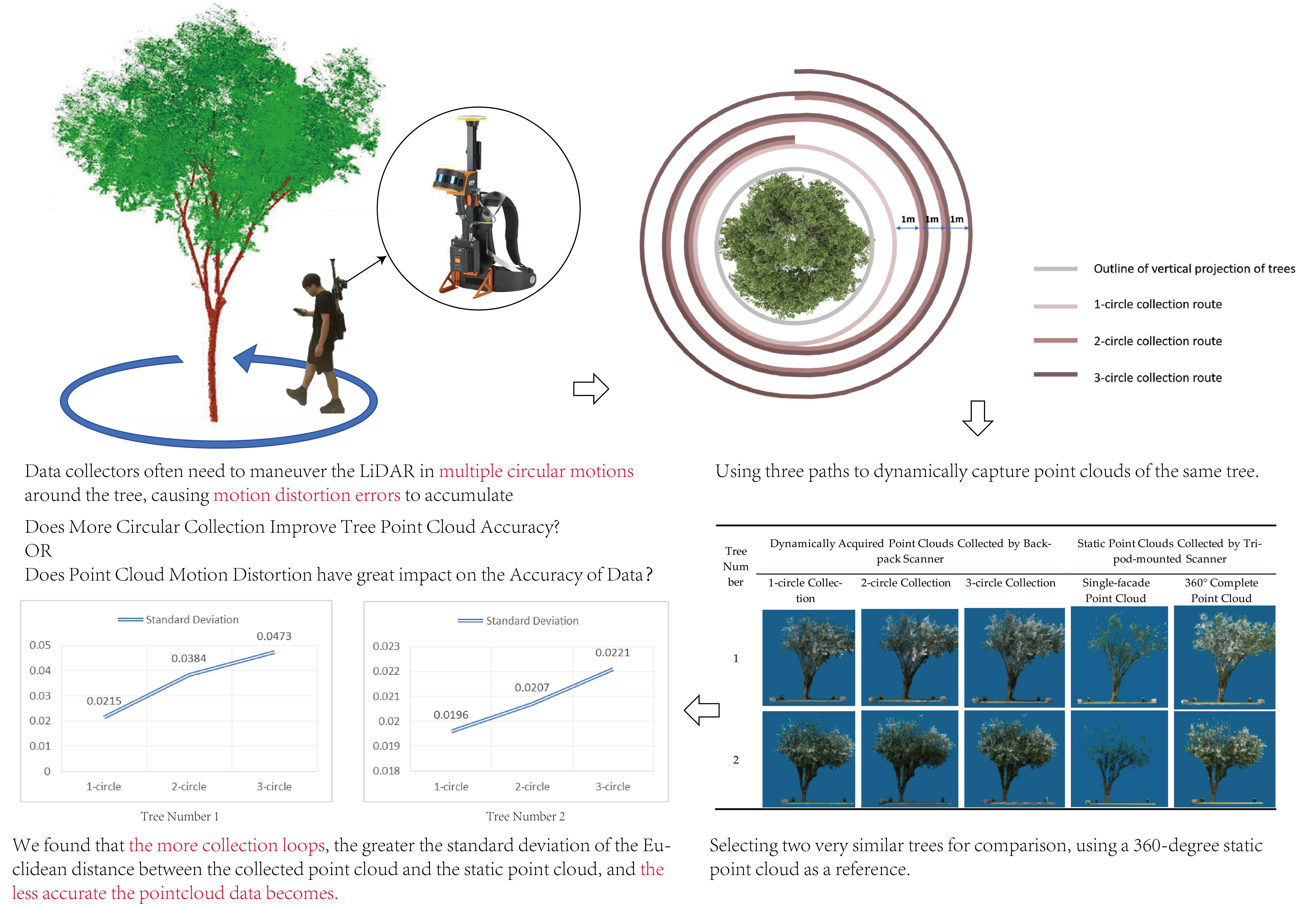
The era of high-quality urban development demands refined, digitalized, and visualized scientific research, and 3D point cloud acquisition technology has emerged as a key tool for tree information collection, surveys, assessment, monitoring, and management, which facilitates the innovative development of the landscape architecture industry. While existing applications primarily focus on batch acquisition of point clouds for tree communities, scattered trees in fields such as ancient and famous tree conservation still rely on backpack/handheld LiDAR devices. These devices often require multiple circular scans around individual trees to ensure point cloud completeness, but motion distortion resulting from such multi-circular mobile acquisition has been generally overlooked. Based on Popper’s falsificationism, this study employs three methods: tree parameter comparison, optical porosity analysis, and CloudCompare-based point cloud distance comparison. These methods are used to observe that motion distortion significantly impairs the accuracy of individual tree point cloud data. Results indicate that motion distortion increases point cloud volume and Euclidean distance errors. Notably, a greater number of collection circles induces random variations in tree morphological parameters and a reduction in point cloud optical porosity. Consequently, tripod-mounted LiDAR is recommended over handheld/backpack devices. Significantly, this study is the first to highlight the potential substantial impact of accumulated point cloud motion distortion on landscape tree point cloud data acquisition. It provides a theoretical foundation for enhancing the precision of dynamically acquired tree point cloud data, which in turn improves the accuracy of tree analysis, monitoring, and assessment studies based on tree point cloud data.
Keywords:
point cloud motion distortion
; urban trees
; backpack LiDAR
1. Introduction
With the advancement of digital technology, digital twin technology has become a key means to identify, reconstruct the physical world, and conduct analysis, decision-making, design, and simulation of real information flow. Among them, three-dimensional point cloud technology, with its unique advantages of high precision, high resolution, and high dimensionality, is gradually becoming an indispensable data support for building digital twins. In addition, due to its multiple advantages such as accurate site information matching [1], efficient communication through visual presentation [2], real-time control of construction quality [3], and refined management of intelligent maintenance [4], three-dimensional point cloud technology is leading the innovative development of the landscape architecture industry throughout the entire lifecycle from preliminary analysis to later operation. Among these applications, using three-dimensional point cloud technology to obtain tree information and promote the digital and intelligent transformation of research fields such as tree information surveys, ecological benefit assessments, greening maintenance monitoring, and ancient tree protection and management has become one of the current focuses of the relevant industries.
Point cloud data, as a core data source for three-dimensional spatial information acquisition, can be categorized into three distinct types based on their acquisition methodologies: static point clouds, dynamic point clouds, and dynamically acquired point clouds [5], with each category defined by the relative motion state between the acquisition equipment and the measured target—static point clouds refer to those where both the target object (e.g., individual trees, buildings) and the point cloud acquisition equipment (such as tripod-mounted laser scanners) remain absolutely stationary during the entire data collection process, ensuring minimal interference from motion-related errors; dynamic point clouds are characterized by stationary acquisition equipment but moving measured objects, commonly used in scenarios like monitoring moving vehicles or growing vegetation where the target’s positional change is the focus of observation; and dynamically acquired point clouds, distinct from the previous two types, refer to those where the acquisition equipment itself is in motion during the collection process. In the context of garden tree surveys and ecological monitoring, the selection of point cloud acquisition type is largely determined by the scale and distribution of the target tree population. For large-area garden tree communities such as urban green belts, forest parks, or campus green spaces—areas that cover extensive territories and consist of dense tree clusters—dynamically acquired point clouds are the preferred choice due to their efficiency and coverage. They are typically collected using mobile LiDAR platforms, including UAV-mounted LiDAR (suitable for large-scale, low-altitude surveys), vehicle-mounted LiDAR (ideal for linear green spaces along roads), and backpack LiDAR (effective for small to medium-sized green areas with complex terrain inaccessible to vehicles) [6]. For targets consisting of a small number of scattered individual trees, such as ancient and famous trees in historical gardens or key landscape trees in urban plazas, static point clouds collected via tripod-mounted LiDAR are more frequently adopted. This equipment, while requiring more time for setup and data acquisition, offers superior precision by eliminating motion-induced errors, making it suitable for scenarios demanding high data accuracy.
LiDAR (Light Detection and Ranging) technology calculates the real three-dimensional coordinates of a measured object through a fundamental working principle: it emits high-frequency laser beams toward the target, then precisely measures the time of flight and intensity of the reflected signals as they return to the sensor, with spatial coordinates derived by combining the speed of light with geometric triangulation algorithms. Accurate measurement of the measured object’s coordinates hinges on a critical prerequisite: the target’s position must remain stable and unchanged throughout the entire laser pulse emission-reception cycle, as any displacement during this brief interval would result in discrepancies between the actual target location at the time of irradiation and the position inferred from the reflected signal [7]. This stability requirement, however, is inherently challenging to meet when LiDAR equipment is in motion during the collection of dynamically acquired point clouds—even with integrated motion stabilization modules such as inertial measurement units (IMUs) or real-time kinematic (RTK) positioning systems [8] , minor positional shifts or attitude adjustments of the moving equipment can disrupt the synchronization between laser emission and signal reception, leading to systematic deviations in the calculated coordinates. These deviations collectively constitute the phenomenon of point cloud motion distortion [9], and as data collection progresses over large areas or prolonged periods, individual small-scale errors accumulate progressively, resulting in the accumulation of associated point cloud inaccuracies that can compromise the reliability of subsequent spatial analysis and structural parameter extraction.
Point cloud motion distortion compensation is a key research topic in autonomous driving-related studies [10]. In road traffic research scenarios, trees are typically considered insignificant urban background elements; ensuring the general outline and actual positions of man-made objects (e.g., buildings, street lamps, and road debris) to guarantee travel safety in a certain extent. However, trees hold significant research significance in the landscape architecture industry, and current research related to garden trees generally lacks attention to the problem of accumulated point cloud motion distortion errors. Current applications of tree point clouds primarily focus on batch acquiring point clouds of tree communities to retrieve tree-related information, with such studies typically collecting data for different target trees sequentially along a specific movement trajectory [11]. Tree point cloud collection via vehicle-mounted LiDAR shares significant similarities with the research environment of autonomous driving. In high-speed vehicle movement scenarios, point cloud motion distortion can substantially impair the accuracy of tree point cloud acquisition [7], yet this issue is rarely addressed in relevant studies [12,13]. When collecting tree point cloud data with handheld or backpack LiDAR, the movement speed during acquisition is significantly lower than that of vehicle-based collection, and the accuracy requirement for individual tree point clouds in batch operations is relatively relaxed. Consequently, point cloud motion distortion has not exerted a significant impact on the batch collection of tree community information, and numerous studies have validated the accuracy of dynamically acquired point clouds for garden tree communities [6].However, whether this distortion significantly affects the accuracy of point cloud data collection for individual garden trees remains an open question.
In research fields such as the conservation of ancient and famous trees [14] and classical gardens [15], several individual garden trees with high historical value are also important research objects. In such research scenarios, due to the scattered distribution and relatively small number of research object trees, it is still necessary to use backpack or handheld LiDAR to collect point cloud information for individual trees one by one [16]. During data collection, LiDAR often needs to be maneuvered to circle the arbor multiple times to ensure the completeness of point cloud acquisition. Despite the slow movement speed, individual tree point clouds typically demand higher accuracy than those of tree communities. However, it remains unclear whether such repeated circular movements around individual garden trees significantly impair the accuracy of point cloud collection.
Existing methods of utilizing tree point clouds can be divided into two categories: extracting tree contour information and extracting internal crown information. Most studies on tree ecological benefit assessments, such as tree volume [17] , carbon storage and biomass [18,19], usually focus on tree contour information provided by point clouds, such as tree height, crown width, and under-crown height, and have relatively low requirements for the accuracy of internal crown point clouds. However, in studies such as canopy structure analysis, individual tree growth status monitoring, and structural parameter estimation, it is often necessary to clarify the internal branch and leaf structure of the crown [20]. Therefore, when using point cloud collection technology to obtain tree information for relevant research, it is necessary to clarify the impact of point cloud distortion on the accuracy of collecting contour and canopy structure information of individual garden trees [21], but research on this issue is currently lacking.
Based on the above analysis, the authors argue that it is imperative to investigate whether point cloud motion distortion exerts a significant impact on the accuracy of dynamically acquired point cloud data for individual garden trees. Taking static point clouds (devoid of motion distortion) as a reference benchmark, this study conducts comparative analysis on the cumulative effects of point cloud motion distortion errors induced by multiple circular collection trajectories around individual garden trees. It quantitatively assesses the extent to which motion distortion influences the accuracy of tree point cloud data and summarizes optimized tree point cloud collection methodologies aimed at mitigating or even eliminating such distortion errors. This research seeks to facilitate advancements in the accuracy of tree-related analyses, monitoring initiatives, and evaluation studies that rely on point cloud data.
2. Materials and Methods
Based on Popper’s falsificationist philosophy [22], this study initially formulates the null hypothesis [23] that ‘point cloud motion distortion exerts no significant impact on the accuracy of point cloud data for individual garden tree’. Research objects are randomly selected, and counterexamples derived from comparative experiments are employed to ‘falsify’ this hypothesis, thereby rejecting it and to prove that point cloud motion distortion may have great impact on the accuracy of individual garden tree point cloud data.
2.1. Selection Criteria and Overview of Research Objects
The research objects were selected based on three criteria: ease of point cloud collection, similar tree contours, and clear canopy structure. Firstly, to reduce interference from the surrounding environment, the research objects should be isolated trees with a certain movement space around them to meet the spatial requirements for circular movement collection. Secondly, to reduce large experimental errors caused by human factors, two trees with high similarity should be selected and collected using the same method to form a comparative reference; therefore, two pairs-planted trees are ideal. Paired planting typically consists of two trees of the same species and comparable size, planted symmetrically on either side of buildings, plazas, roads, or other features. This arrangement enhances the sense of symmetry in landscape spaces through the uniform tree forms and equidistant distribution perpendicular to the axis, making them ideal paired research samples. Thirdly, to conduct a comprehensive and in-depth study on the impact of point cloud motion distortion on the accuracy of tree canopy structure information, research objects are specifically selected for their distinct crown pores and moderate canopy optical porosity. This targeted selection ensures the studied trees possess relatively clear and distinguishable canopy structural characteristics, laying a solid foundation for accurate identification and quantitative analysis of distortion-induced changes in canopy internal structure parameters.
In summary, this research selected two paired planting Malus micromalus trees as research objects for replicable falsification (Figure 1). These two arbors are planted symmetrically on the campus of a university in Haidian District, Beijing, with relatively clear canopy structural characteristics, basically meeting the above requirements. This area belongs to a temperate humid monsoon climate, with cold and dry winters and hot and rainy summers. Malus micromalus, a small arbor belonging to Malus of Rosaceae in Magnoliopsida, has a height of 2.5–5 m, with upright branches, narrow and long leaves and moderate optical porosity. It grows well in Beijing, featuring elegant flowers and a neat tree form with high ornamental value, and is a widely applied garden tree species known as the ‘National Beauty’.
2.2. Point Cloud Data Collection and Preprocessing
In garden tree research, dynamically acquired point clouds are commonly collected via two primary devices: UAV LiDAR, suited for large-scale surveys in unrestricted airspace, and backpack LiDAR, which is preferable for small-scale collection and delivers relatively higher accuracy owing to its close proximity to target trees. Tripod-mounted LiDAR, by contrast, can collect static point clouds with the highest accuracy and no motion distortion, yet it has been gradually replaced by the other two due to its cumbersome operation and high time cost. This study chose to use a high-precision backpack LiDAR to collect tree point clouds through multiple circular movements around individual trees to accumulate motion distortion errors, and used tripod-mounted LiDAR without point cloud motion distortion for comparative validation.
In June 2025, under weather conditions with moderate lighting, cloudy skies, and no wind, researchers carried an OmniSlAM Intelligent R8+ rotating single-laser backpack scanner to scan and measure these two Malus micromalus trees selected as research objects. This equipment utilizes the simultaneous localization and mapping (SLAM) technology to achieve perception and capture of the tree environment, and is equipped with RTK technology to obtain centimeter-level precise positioning. The equipment’s scanning data frequency is 640,000 points per second, with a field of view of 270° vertically and 360° horizontally, and a relative collection accuracy of 2mm. The scanning route was designed with the center of the tree trunk as the circle center, 1m outside the vertical projection of the crown, and three collections were performed at intervals of 1m per circle (Figure 2). Meanwhile, another researcher carried a FARO Focus Plus S70 tripod-mounted laser scanner to collect data for the two Malus micromalus trees. This equipment has a scanning data frequency of 1 million points per second, a field of view of 300° vertically and 360° horizontally, and a relative collection accuracy of 2mm. To ensure the full collection of complete tree point clouds, it was necessary to set up four stations for each tree in the east, south, west, and north directions using this equipment, with 4 stations collected per tree and each station collecting for approximately 5 minutes. Due to the limitation of human eye perspective, the single-facade point clouds collected are difficult to capture the complete point clouds of the crown top. Subsequently, the 4 stations were stitched into a complete 360° point cloud of the individual garden tree using the internal point cloud collection software of FARO.
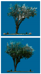
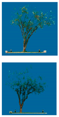
The acquired point cloud data contains both the target research trees and their surrounding environmental features; additionally, the point clouds exhibit certain positional deviations due to inconsistent coordinate systems associated with different collection devices. Accordingly, point cloud registration must be conducted in professional processing software (e.g., Trimble RealWorks), followed by manual elimination of non-target environmental point clouds, which ultimately yields two sets of valid point cloud datasets for subsequent research (Table 1).
2.3. Subsection
As shown in Table 1, the point clouds collected from a single facade are evidently incomplete and fail to meet the basic requirements for point cloud data acquisition, thus such point clouds are discarded and only the 360° stitched point clouds are adopted for subsequent research. The tripod-mounted LiDAR involves no equipment movement during collection, and its point cloud motion distortion error is nearly zero under calm or light wind conditions, making the 360° stitched static point clouds acquired by this method the reference benchmark for tree point cloud comparison in this study. Considering that point cloud motion distortion may impair the accuracy of both tree contour information and internal crown information, this study verifies the distortion’s impact on contour information via tree parameter comparison and on internal crown information through optical porosity depth image comparison. Additionally, CloudCompare software is employed to compare the cumulative distortion errors of all spatial coordinate points of the target trees across different point cloud collection methods.
2.3.1. Tree Parameter Collection
Extracting key tree morphological parameters (e.g., tree height, crown width, and diameter at breast height (DBH)) from point cloud data constitutes a fundamental step in most relevant tree research. It is therefore essential to compare the parameter errors derived from distorted and undistorted tree point clouds to determine whether motion distortion exerts a significant influence on the accuracy of acquiring these basic morphological metrics. The effectiveness of Trimble RealWorks software for point cloud-based measurement has been validated by numerous scholars [24,25]; this study thus employs the software to measure tree height, crown width, DBH and other basic morphological parameters from the point cloud data, and further elaborates on the comparison results by calculating the absolute errors (AEs) and relative absolute errors (RAEs) of each parameter [26].
2.3.2. Optical Porosity Comparison
Given that point cloud motion distortion may exerts a significant influence on the internal point cloud data of trees, which may distorts the contour features of crown pores and thereby alters key canopy structural characteristics including tree optical porosity, this study conducts a comparative investigation into the impact of such distortion on the measurement accuracy of tree facade optical porosity. For the quantification of tree facade optical porosity, the classical optical porosity calculation formula proposed by Cao Xinsun [27] is adopted in this research:
Where β represents optical porosity, s represents the projected area of light-transmitting pores, and S represents the total projected area of the tree frontal view.
The statistical analysis of projected area typically relies on professional image processing software including Photoshop and Image-Pro Plus [28,29]. Accordingly, tree point cloud data was first exported as front facade images in CloudCompare, and the RGB color images of tree canopies were converted to grayscale in Photoshop; the processed images were required to clearly display all light-permeable pores, as well as the gaps between adjacent leaves or branches that are less than one-fourth the width of leaf closed areas [30]. Subsequently, following the method proposed by Zhou et al.[31] the tree facade grayscale images were imported into Image-Pro Plus for grayscale value difference analysis, which enabled the accurate segmentation of crown pore regions from solid vegetative areas. Finally, the grid areas of pore and non-pore regions were statistically quantified to calculate canopy optical porosity, and the two regions were binarized into black and white to visually and intuitively reflect the differences in optical porosity derived from different point cloud acquisition methods.
2.3.3. CloudCompare Point Cloud Distance Comparison
The calculation of tree optical porosity is inherently susceptible to subjective factors during the grayscale processing of canopy images, necessitating a further comparison of the actual spatial distances among different point cloud datasets to conduct a rigorous quantitative analysis of inter-point cloud errors. CloudCompare is a widely adopted software for point cloud visualization and quantitative analysis; its Tool/Distances/Cloud-to-Cloud Dist. module enables the accurate calculation of the Euclidean distance between corresponding point sets of different tree point clouds, which serves to evaluate the spatial fitting degree and error magnitude of distinct point cloud data. A smaller absolute Euclidean distance value indicates a higher spatial fitting degree between the two point cloud datasets and a smaller systematic error in the point cloud acquisition and processing process.
3. Results
3.1. Comparative Analysis of Basic Morphological Parameters of Trees
Taking the basic morphological parameters of trees derived from tripod-mounted static point clouds as the undistorted reference standard, the dynamically acquired point clouds collected by the backpack LiDAR exhibit certain deviations in key basic morphological parameters (including tree height, crown width, and diameter at breast height (DBH)) in comparison (Table 2). The impact errors induced by the accumulation of point cloud motion distortion on the basic morphological parameters of the tree outer contour fluctuate within the range of 0.1 cm to 14.6 cm, while the relative absolute errors vary between 0.01% and 4.70%, presenting a random variation trend. Notably, an increase in the number of circular collection movements may result in a random increment or decrement in the basic morphological parameters extracted from the tree point clouds.
Among the comparative analyses of the three types of basic morphological parameters (tree height, crown width, and diameter at breast height (DBH)), the relative error of DBH exhibits the most significant variation (Figure 3). This phenomenon can be attributed to the substantial difference in the magnitude of DBH compared to tree height and crown width: DBH is typically measured in centimeters, whereas tree height and crown width are quantified in meters. In fact, as illustrated in Table 2, the variation range of the absolute error of DBH (0.1 cm–2.9 cm) is narrower than that of tree height (0.2 cm–11.3 cm) and crown width (2.1 cm–14.6 cm). This discrepancy in error variation ranges is associated with the pore characteristics of the measured tree components.
For crown width measurement, the target region is the tree canopy, which contains a large number of complex pore spaces formed by the interlacing of branches and leaves. Consequently, when irradiated by laser pulses during LiDAR acquisition, the laser is prone to penetrating these pores and reaching the inner canopy rather than being reflected by the canopy surface, leading to the acquisition of inaccurate spatial coordinates for the crown boundary. In contrast, tree height measurement primarily relies on the point cloud coordinates of the crown top. This portion of the canopy is generally relatively dense due to favorable lighting conditions, with fewer pores, which reduces laser penetration and facilitates the acquisition of the real spatial position of the crown top. DBH measurement, on the other hand, targets the solid tree trunk, where internal pore spaces are almost absent. This eliminates the interference of pore-induced laser penetration on coordinate acquisition, resulting in the narrowest variation range of absolute error among the three morphological parameters.
3.2. Comparative Analysis of Basic Morphological Parameters of Trees
Table 3 presents the black-and-white binarization processing results of the optical porosity depth images corresponding to different point cloud acquisition methods. It is clearly observed that the optical porosity of the point cloud data collected via 1–3 rounds of circular motion is generally lower than that of the static point clouds acquired by tripod-mounted LiDAR. This finding indicates that point cloud motion distortion is prone to inducing incorrect inversion of target spatial coordinates, thereby rendering the obtained tree point clouds denser than the actual undistorted tree point clouds.
Overall, with an increase in the number of circular collection movements during point cloud acquisition, the optical porosity of the obtained tree point clouds exhibits a decreasing trend, indicating an inverse proportional relationship may incur between the number of collection circles and the optical porosity of tree point clouds (Figure 4). Specifically, a greater number of collection circles leads to more incorrect point cloud coordinates inverted by the laser due to motion distortion, resulting in denser acquired point clouds. When the number of collection circles reaches 3, the error between the collected tree point clouds and the undistorted static point clouds acquired by tripod-mounted LiDAR (representing real tree morphology) is approximately 50%. Even with a single collection circle, an optical porosity error of around 30% can be induced.
These results demonstrate that point cloud motion distortion may exerts a significant negative impact on the accuracy of acquiring internal crown information from tree point clouds. Notably, increasing the number of collection circles does not guarantee higher accuracy in tree point cloud acquisition; on the contrary, it may lead to the accumulation of substantial distortion errors and the generation of numerous spurious coordinate points that do not correspond to actual tree structures.
3.3. Comparative Analysis of Basic Morphological Parameters of Trees
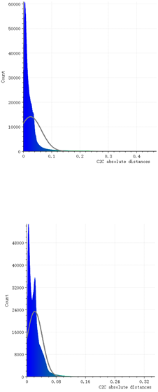
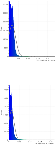
Significant differences were observed in the distance comparison results between the point cloud data acquired with different numbers of circular collection movements and the tripod-mounted static point clouds. In Table 4, the abscissa denotes the Euclidean distance between corresponding points of the two groups of point clouds, measured using CloudCompare software, while the ordinate represents the count of point cloud points with a specific Euclidean distance. A larger Euclidean distance indicates a greater positional error between the compared points.
In general, for two groups of point cloud datasets with minimal errors, their distance distribution should conform to a normal distribution—i.e., the number of coordinate points with errors close to 0 is the largest, and the count of points with larger errors decreases gradually. However, in this study, both experimental trees exhibited a trend where the number of circular collection movements was inversely proportional to the standard deviation of point cloud distance errors (Figure 5). Combined with Table 4, when the number of collection circles was 1, the distance distribution basically conformed to a normal distribution. In contrast, as the number of collection circles increased, the dispersion of the distance distribution increased significantly and gradually deviated from the normal distribution, indicating that the number of points with larger positional errors increased with the number of collection circles.
This phenomenon can be attributed to the cumulative effect of motion distortion errors per collection circle, which leads to a gradual increase in the number of incorrect point cloud coordinates. Although these incorrect coordinates generally do not deviate further from the real spatial coordinates, they accumulate within the range of erroneous positions. When the number of collection circles reached 3, it had obviously exerted a significant negative impact on the accuracy of point cloud acquisition, presenting a trend where more collection circles resulted in more incorrect coordinate points. This finding is consistent with the results of the optical porosity comparative analysis, further verifying the potential adverse effect of cumulative motion distortion on point cloud accuracy.
4. Discussion
In recent years, the adoption of 3D point cloud technology for acquiring tree point cloud data has emerged as a pivotal research method in the landscape architecture field. However, most relevant studies directly apply this technology for data collection while neglecting its key application criteria and the potential adverse impacts of inappropriate acquisition methods on the accuracy of individual garden tree point cloud data. This study highlights and conducts an initial quantification of the point cloud motion distortion phenomenon. During the multi-circular collection of individual tree point clouds via mobile acquisition, motion distortion induces measurable errors in the acquired data relative to the static point clouds obtained by tripod-mounted LiDAR, which is mainly characterized by an increase in redundant point cloud points and elevated Euclidean distance errors among point sets. Such distortion exerts divergent effects on the extraction of tree basic morphological parameters and internal crown structural information.
For the extraction of tree basic morphological parameters, an increase in the number of circular collection passes may leads to random fluctuations—both increases and decreases—in parameters including tree height, crown width and diameter at breast height (DBH), with the overall relative absolute error ranging from 0.01% to 4.70%. This indicates that point cloud motion distortion is likely to compromise the measurement accuracy of tree basic morphological parameters in research requiring high data precision, and no significant positive or negative correlation is observed between the number of collection passes and the variation trend of these morphological parameters.
In terms of internal crown information extraction, the number of circular collection passes exhibits an inverse proportional relationship with the optical porosity of tree point clouds: a greater number of passes results in denser acquired point clouds and lower optical porosity values. Notably, even a single collection pass can induce an approximate 30% error in optical porosity measurement, demonstrating that point cloud motion distortion may exerts a significant negative impact on the accuracy of internal crown information derived from tree point cloud data.
Based on the findings of this study, in research scenarios requiring high-precision point cloud data—such as those involving the measurement of individual tree basic morphology or the study of tree canopy structure—handheld or backpack LiDAR devices should not be employed for multi-circular mobile acquisition around trees, so as to avoid the significant adverse impacts induced by point cloud motion distortion. Instead, tripod-mounted LiDAR devices are recommended for acquiring static tree point clouds that are free from motion distortion, which is conducive to enhancing the accuracy of tree-related analysis, monitoring, and evaluation studies relying on point cloud data. The mobile acquisition method using handheld or backpack LiDAR for tree point cloud collection is only applicable to research scenarios focused on visualization, where the requirements for point cloud data accuracy are relatively low.
Compared with other landscape elements such as terrain, buildings, and stone placements, plants have significant complexity. Their interspersed virtual and real morphological attributes make it more difficult to define spatial contour boundaries compared to solid structures such as buildings and rockeries. The outer contour of the crown with numerous irregularities is complex, and the internal interlaced canopy pore space structure is also difficult to parse. Therefore, laser irradiation inversion and point cloud data acquisition should be more difficult than for other elements, with more considerations. The development of information technology has endowed handheld or backpack LiDAR devices with more convenient application scenarios in research related to garden trees. However, the selection of research methods needs to fully consider the characteristics of the research objects and the requirements of the research objectives, ensuring high data accuracy while pursuing high technology and efficiency.
This study takes two tree specimens as case studies to refute the research hypothesis that ‘point cloud motion distortion exerts no significant influence on the data accuracy of individual garden tree point clouds’, and preliminarily verifies that point cloud motion distortion may have a notable impact on tree point cloud accuracy. This finding serves as a critical reminder for the long-standing practice of multi-circular point cloud acquisition for individual trees. While the research conclusions are logically consistent and empirically supported, the study is limited by a relatively small sample size. Future research is thus recommended to expand the sample scale of research subjects, so as to derive more comprehensive and universally applicable research findings for the field.
Author Contributions
Four authors make contributions for this research. Conceptualization, Yunqi. W.; Yang. W.; Hao. Y.; Xinyu. W. methodology, Yunqi. W.; software, Yunqi, W. and Xinyu. W. validation, Yang. W. and Hao Y.; formal analysis, Yunqi. W.; Yang. W. and Xinyu. W.; investigation, Yunqi. W.; Yang. W. and Xinyu. W.; resources, Hao Y,.; data curation, Yang. W. and Hao. Y.; writing—original draft preparation, Yunqi. W.; writing—review and editing, Yunqi. W.; Yang. W.; Hao. Y.; Xinyu. W.; visualization, Yunqi. W.; supervision, Yunqi. W.; Yang. W. and Hao. Y.; project administration, Yunqi. W.; funding acquisition, Hao. Y. All authors have read and agreed to the published version of the manuscript.
Funding
Please add: This research was funded by “Beijing Municipal Co-construction Project Special Funding”, grant number “2019GJ-03”,and Beijing Forestry University Hotspot Tracking Project “Research on the Application Level and Improvement Strategies of Plant Landscape Resources in Urban Human Settlements”, grant number “2022BLRD05”.
Data Availability Statement
Data is unavailable due to privacy or ethical restrictions.
Acknowledgments
The authors thank the technical support for point cloud acquisition equipment provided by Jiazhong Li and his team.
Conflicts of Interest
The authors declare no conflicts of interest.The funders had no role in the design of the study; in the collection, analyses, or interpretation of data; in the writing of the manuscript; or in the decision to publish the results.
Abbreviations
The following abbreviations are used in this manuscript:
| CW | Crown Width |
| Ht | Tree Height |
| DBH | Diameter at Breast Height |
| AEs | Absolute Error |
| RAE | Relative Error |
References
- Yong, G.; Yunqi, W.; Cuiyu, O. Research on LIM-Based Simulation of Carbon Stock Baseline Scenario in Urban Trees: Taking the Green Space of a University in Beijing as an Example. J. Beijing For. Univ. 2023, 44, 111–120. [Google Scholar]
- Kuniyoshi, I.; Nagaike, I.; Sato, S.; Bao, Y. Building Damage Visualization through Three-Dimensional Reconstruction and Window Detection. Sens. 2025, 25, 2979. [Google Scholar] [CrossRef] [PubMed]
- Wang, B.; Lin, F.; Li, M.; Liang, Z.; Yue, H.; Wang, Q.; Cheng, J.C.P. Aligning As-Built and as-Designed: Local Point Cloud to BIM Registration via Hybrid Visibility Map Encoding for Construction Digital Twins. Autom. Constr. 2025, 180, 106551. [Google Scholar] [CrossRef]
- Yunqi, W.; Yang, W.; Hao, Y. A Low-Density Tree Digital Twin Model for Refined Urban Greening Management: A Case Study of Tree Wind Disaster Risk Management. J. Beijing For. Univ. 2025, 47, 139–150. [Google Scholar]
- Schwarz, S.; Preda, M.; Baroncini, V.; Budagavi, M.; Cesar, P.; Chou, P.A.; Cohen, R.A.; Krivokuća, M.; Lasserre, S.; Li, Z.; et al. Emerging MPEG Standards for Point Cloud Compression. IEEE J. Emerg. Sel. Top. Circuits Syst. 2019, 9, 133–148. [Google Scholar] [CrossRef]
- Li, X.-X.; Tang, L.-Y.; Peng, W.; Chen, J.-X.; Ma, X. Estimation Method of Urban Green Space Living Vegetation Volume Based on Backpack Light Detection and Ranging. Ying Yong Sheng Tai Xue Bao= J. Appl. Ecol. 2022, 33, 2777–2784. [Google Scholar] [CrossRef] [PubMed]
- Zhang, Q.; Khoche, A.; Yang, Y.; Ling, L.; Mansouri, S.S.; Andersson, O.; Jensfelt, P. HiMo: High-Speed Objects Motion Compensation in Point Clouds 2025. [CrossRef]
- Shi, J.; Wang, W.; Li, X.; Yan, Y.; Yin, E. Motion Distortion Elimination for LiDAR-Inertial Odometry under Rapid Motion Conditions. IEEE Trans. Instrum. Meas. 2023, 72, 1–16. [Google Scholar] [CrossRef]
- McDermott, M.; Rife, J. Correcting Motion Distortion for LIDAR Scan-to-Map Registration. IEEE Robot. Autom. Lett. 2024, 9, 1516–1523. [Google Scholar] [CrossRef]
- Haas, L.; Haider, A.; Kastner, L.; Zeh, T.; Poguntke, T.; Kuba, M.; Schardt, M.; Jakobi, M.; Koch, A.W. Velocity Estimation from LiDAR Sensors Motion Distortion Effect. Sens. 2023, 23, 9426. [Google Scholar] [CrossRef] [PubMed]
- Min, L.; Na, T.; Maowei, L.; Hao, Z.; Yufeng, W.; Shuai, H.; Rula, S. Extraction of DBH and tree height of natural forest in Daxing’an Mountains based on backpack lidar. J. Inn. Mong. Agric. Univ. (Natural Science Edition) 2025. (in Chinese). [Google Scholar]
- Xiaohe, L. Tree Extraction and Analysis Based on Vehicle Point Cloud Data. Bull. Surv. Mapp. 2020, 163. [Google Scholar]
- Yuheng, Z.; Hongping, Z. Research Progress of Tree Canopy Feature Information Extraction Based on Laser Point Cloud. J. Chin. Agric. Mech. 2024, 45, 142. [Google Scholar]
- Yang, W.; Wilkes, P.; Vicari, M.B.; Hand, K.; Calders, K.; Disney, M. Treegraph: Tree Architecture from Terrestrial Laser Scanning Point Clouds. Remote Sens. Ecol. Conserv. 2024, 10, 755–774. [Google Scholar] [CrossRef]
- Li, F.; Achille, C.; Vassena, G.P.M.; Fassi, F. Others The Application of Three Dimensional Digital Technologies in Historic Gardens and Related Cultural Heritage: A Scoping Review. Heritage 2025, 8, 46–75. [Google Scholar] [CrossRef]
- Yang, J.; Yuan, W.; Lu, H.; Liu, Y.; Wang, Y.; Sun, L.; Li, S.; Li, H. Assessing the Performance of Handheld Laser Scanning for Individual Tree Mapping in an Urban Area. Forests 2024, 15, 575. [Google Scholar] [CrossRef]
- Adhikari, A.; Peduzzi, A.; Montes, C.R.; Osborne, N.; Mishra, D.R. Assessment of Understory Vegetation in a Plantation Forest of the Southeastern United States Using Terrestrial Laser Scanning. Ecol. Inf. 2023, 77, 102254. [Google Scholar] [CrossRef]
- Wu, L.; Shi, Y.; Zhang, F.; Zhou, Y.; Ding, Z.; Lv, S.; Xu, L. Estimating Carbon Stocks and Biomass Expansion Factors of Urban Greening Trees Using Terrestrial Laser Scanning. Forests 2022, 13, 1389. [Google Scholar] [CrossRef]
- Fan, G.; Lu, F.; Cai, H.; Xu, Z.; Wang, R.; Zeng, X.; Xu, F.; Chen, F. A New Method for Reconstructing Tree-Level Aboveground Carbon Stocks of Eucalyptus Based on TLS Point Clouds. Remote Sens. 2023, 15, 4782. [Google Scholar] [CrossRef]
- Xiaoran, L.; Aijun, X.; Suyin, Z.; Junhua, Y. Single Tree Skeleton Extraction Algorithm Based on Terrestrial Ground LiDAR Point Clouds. J. Zhejiang A&F Univ. 2025, 42, 684–693. [Google Scholar]
- Burmeister, J.-M.; Tockner, A.; Reder, S.; Engel, M.; Richter, R.; Mund, J.-P.; Döllner, J. treeX: Unsupervised Tree Instance Segmentation in Dense Forest Point Clouds. arXiv 2025, arXiv:2509. [Google Scholar]
- Popper, K.R. Science as Falsification. Conjectures Refutations 1963, 1, 33–39. [Google Scholar]
- Nickerson, R.S. Null Hypothesis Significance Testing: A Review of an Old and Continuing Controversy. Psychol. Methods 2000, 5, 241–301. [Google Scholar] [CrossRef] [PubMed]
- Weili, J. Application of 3D Laser Scanning Technology in Assembly Line Construction. Bull. Surv. Mapp. 2018, 153. [Google Scholar]
- Shi, F.; Yang, J.; Li, Q.; He, J.; Chen, B. 3D Laser Scanning Acquisition and Modeling of Tunnel Engineering Point Cloud Data. J. Phys. Conf. Ser. 2023, 2425, 12064. [Google Scholar] [CrossRef]
- Palme, M.; Privitera, R.; La Rosa, D. The Shading Effects of Green Infrastructure in Private Residential Areas: Building Performance Simulation to Support Urban Planning. Energy Build. 2020, 229, 110531. [Google Scholar] [CrossRef]
- Xinsun, C. Farmland Shelterbelt Science [M] 1983.
- An, L.; Wang, J.; Xiong, N.; Wang, Y.; You, J.; Li, H. Assessment of Permeability Windbreak Forests with Different Porosities Based on Laser Scanning and Computational Fluid Dynamics. Remote Sens. 2022, 14, 3331. [Google Scholar] [CrossRef]
- Jia, X.; Xiao, H.; Xin, Z.; Li, J.; Fan, G. Determining the Structural Characteristics of Farmland Shelterbelts in a Desert Oasis Using LiDAR. Forests 2025, 16, 1221. [Google Scholar] [CrossRef]
- Gillies, J.A.; Nickling, W.G.; King, J. Drag Coefficient and Plant Form Response to Wind Speed in Three Plant Species: Burning Bush (Euonymus Alatus), Colorado Blue Spruce (Picea Pungens Glauca.), and Fountain Grass (Pennisetum Setaceum). J. Geophys. Res. Atmos. 2002, 107, ACL 10-1-ACL 10-15. [Google Scholar] [CrossRef]
- Zhou, J.; Lei, J.; Sun, L. Others The Feasibility Analysis of Image-pro plus in Calculating the Optical Porosity of Windbreaks. J. Arid Land Res. Env. 2015, 12, 109–114. [Google Scholar]
Figure 1.
This is a figure. Schemes follow the same formatting.
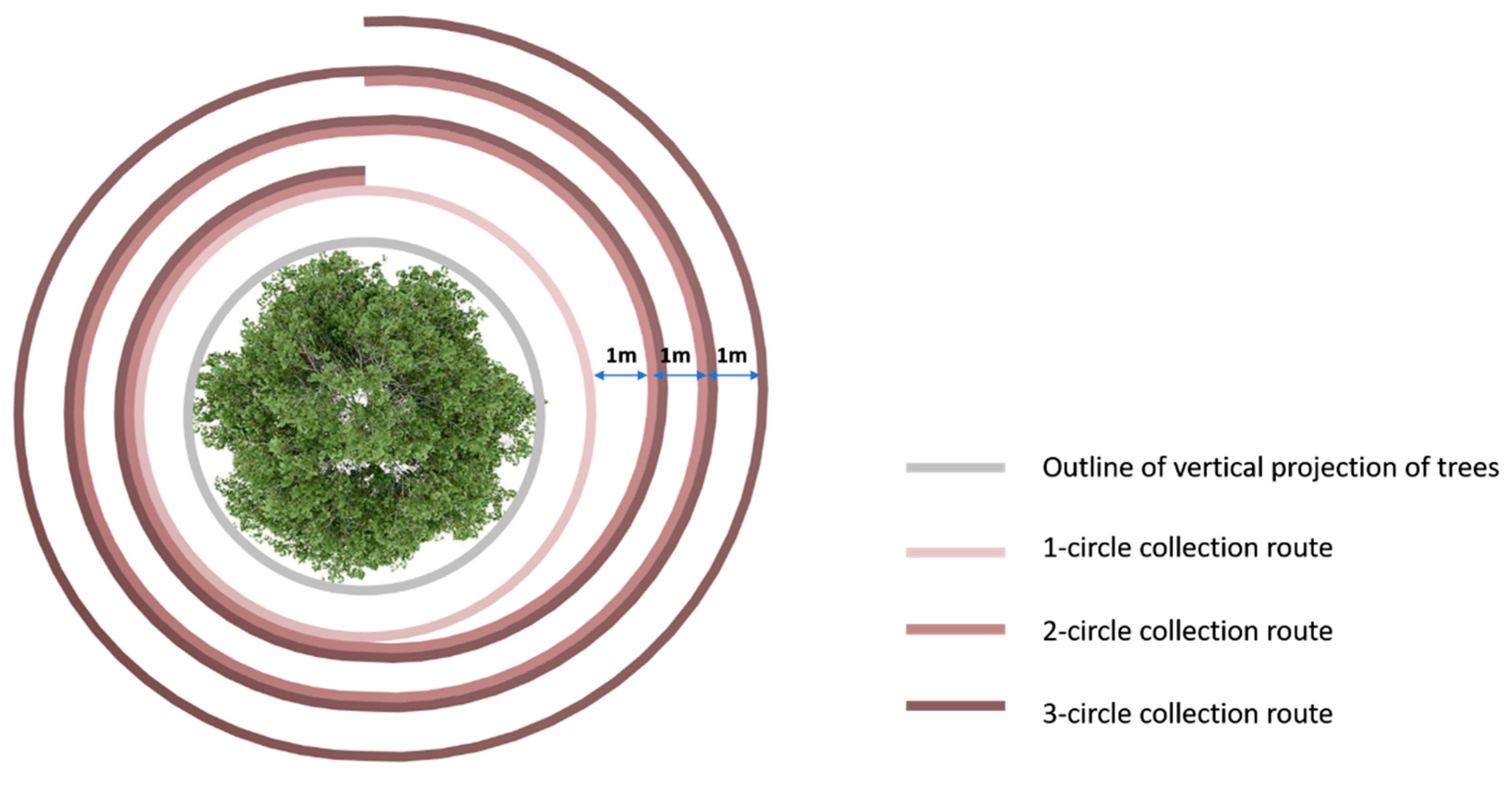
Figure 3.
Statistics of relative errors of basic morphological parameters of point clouds collected with different numbers of movement circles (a: 1# Tree, b: 2# Tree).
Figure 3.
Statistics of relative errors of basic morphological parameters of point clouds collected with different numbers of movement circles (a: 1# Tree, b: 2# Tree).
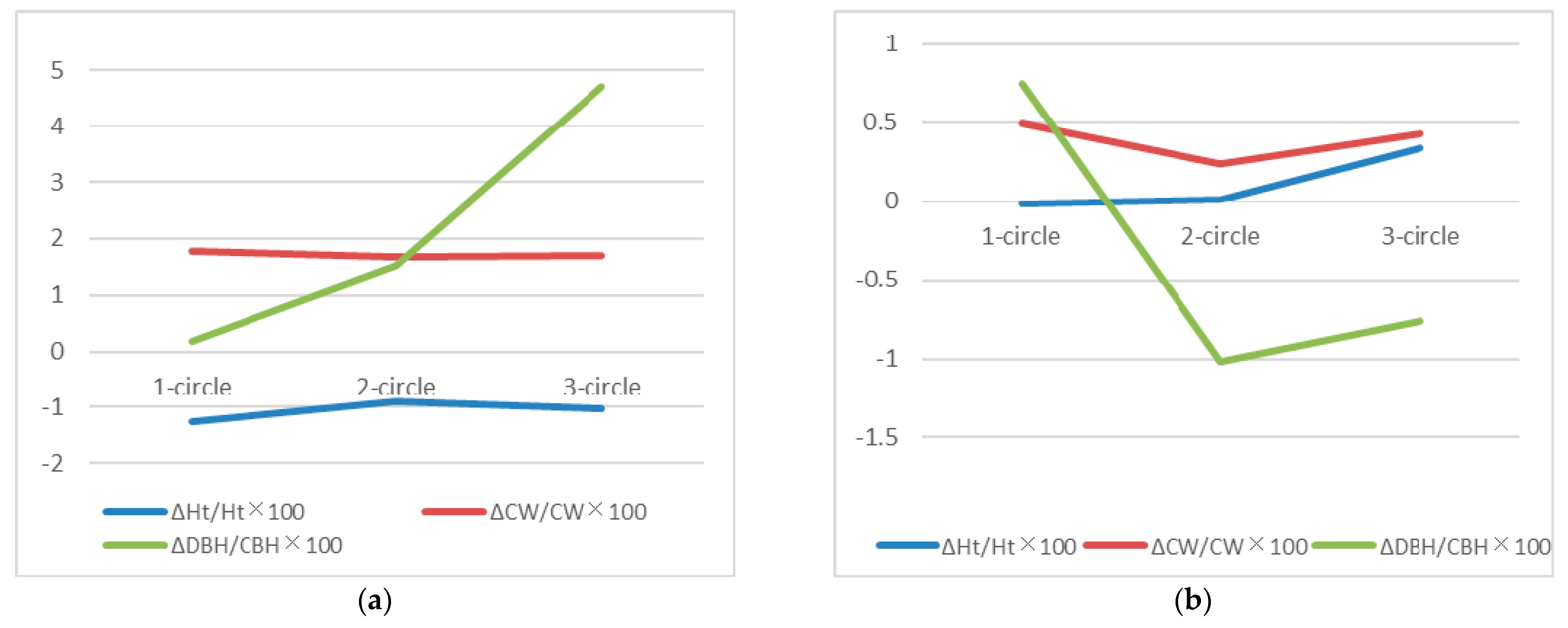
Figure 4.
Error percentage of point clouds obtained with different numbers of collection circles compared to real tree point clouds.
Figure 4.
Error percentage of point clouds obtained with different numbers of collection circles compared to real tree point clouds.
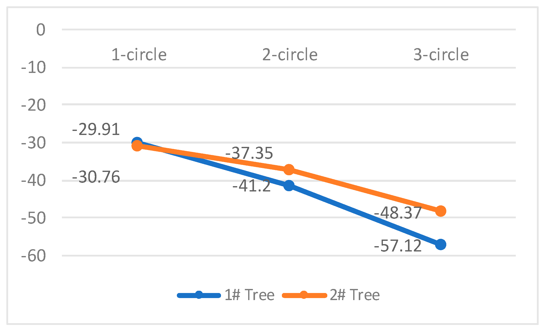
Figure 5.
Statistical chart of standard deviations of Euclidean distances of each coordinate point between point clouds collected with different numbers of movement circles and tripod-mounted static point clouds for the two trees measured by CloudCompare (a: 1# Tree, b: 2# Tree).
Figure 5.
Statistical chart of standard deviations of Euclidean distances of each coordinate point between point clouds collected with different numbers of movement circles and tripod-mounted static point clouds for the two trees measured by CloudCompare (a: 1# Tree, b: 2# Tree).
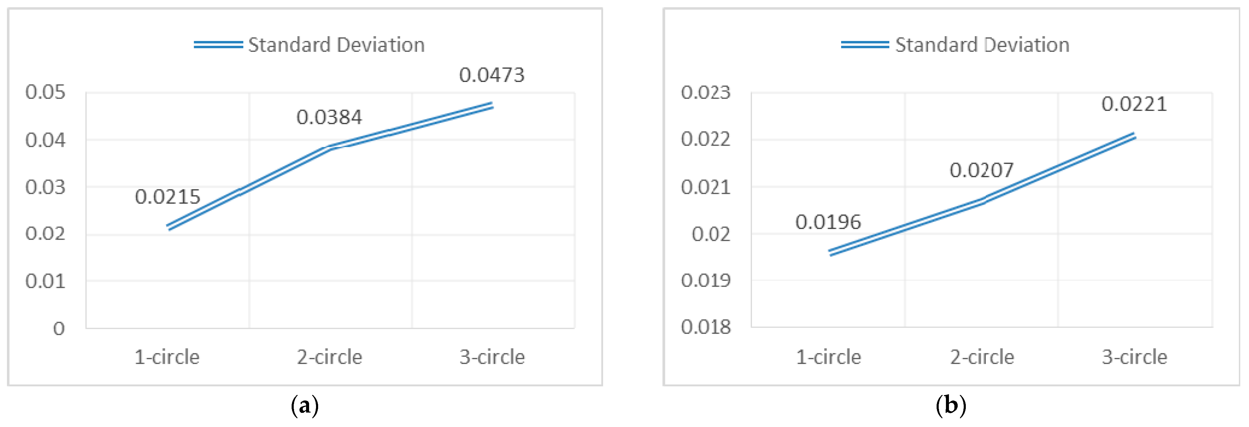

Table 1.
Results of tree point cloud data obtained by different point cloud collection schemes.
| Tree Number | Dynamically Acquired Point Clouds Collected by Backpack Scanner | Static Point Clouds Collected by Tripod-mounted Scanner | |||
| 1-circle Collection | 2-circle Collection | 3-circle Collection | Single-facade Point Cloud | 360° Complete Point Cloud | |
| 1 |  |
 |
 |
 |
 |
| 2 | |||||
Table 2.
Comparative results of basic morphological parameters of tree point clouds collected by different methods.
Table 2.
Comparative results of basic morphological parameters of tree point clouds collected by different methods.
| Tree Number | Collection Method & Point Cloud Type | Actual measurement | AEs(m) | RAEs(%) | ||||||
|---|---|---|---|---|---|---|---|---|---|---|
| Ht | CW | DBH | ΔHt | ΔCW | ΔDBH | ΔHt/Ht×100 | ΔCW/CW×100 | ΔDBH/CBH×100 | ||
| 1 | Tripod-mounted Static pcd | 9.097 | 8.106 | 0.588 | / | / | / | / | / | / |
| 1-circle motion pcd | 8.984 | 8.252 | 0.589 | -0.113 | 0.146 | 0.001 | -1.26 | 1.77 | 0.17 | |
| 2-circle motion pcd | 9.015 | 8.244 | 0.597 | -0.082 | 0.138 | 0.009 | -0.91 | 1.67 | 1.51 | |
| 3-circle motion pcd | 9.004 | 8.245 | 0.617 | -0.093 | 0.139 | 0.029 | -1.03 | 1.69 | 4.70 | |
| 2 | Tripod-mounted Static pcd | 8.995 | 8.817 | 0.398 | / | / | / | / | / | / |
| 1-circle motion pcd | 8.993 | 8.860 | 0.401 | -0.002 | 0.043 | 0.003 | -0.02 | 0.49 | 0.75 | |
| 2-circle motion pcd | 8.996 | 8.838 | 0.394 | 0.001 | 0.021 | -0.004 | 0.01 | 0.24 | -1.02 | |
| 3-circle motion pcd | 9.026 | 8.855 | 0.395 | 0.031 | 0.038 | -0.003 | 0.34 | 0.43 | -0.76 | |
Note: CW denotes crown width, Ht denotes tree height, DBH denotes diameter at breast height, AEs denotes absolute error, RAE denotes relative error, and pcd is the abbreviation for point cloud.
Table 3.
Black-and-white binarization processing results of optical porosity depth images corresponding to different point cloud collection methods.
Table 3.
Black-and-white binarization processing results of optical porosity depth images corresponding to different point cloud collection methods.
| Tree Number | Dynamically Acquired Point Clouds | Static Point Clouds(reference) | ||
| 1-circle collection | 2-circle collection | 3-circle collection | 360° Complete Point Cloud | |
| 1 |  |
 |
 |
 |
| 7.348% | 6.165% | 4.496% | 10.484% | |
| 2 |  |
 |
 |
 |
| 5.001% | 4.525% | 3.729% | 7.223% | |
Table 4.
Statistical chart of Euclidean distance distribution of each coordinate point between point clouds collected with different numbers of movement circles and tripod-mounted static point clouds measured by CloudCompare.
Table 4.
Statistical chart of Euclidean distance distribution of each coordinate point between point clouds collected with different numbers of movement circles and tripod-mounted static point clouds measured by CloudCompare.
| Tree Number | 1-circle motion pcd | 2-circle motion pcd | 3-circle motion pcd |
| 1 | 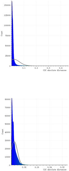 |
 |
 |
| 2 |
Disclaimer/Publisher’s Note: The statements, opinions and data contained in all publications are solely those of the individual author(s) and contributor(s) and not of MDPI and/or the editor(s). MDPI and/or the editor(s) disclaim responsibility for any injury to people or property resulting from any ideas, methods, instructions or products referred to in the content. |
© 2026 by the authors. Licensee MDPI, Basel, Switzerland. This article is an open access article distributed under the terms and conditions of the Creative Commons Attribution (CC BY) license (http://creativecommons.org/licenses/by/4.0/).
Copyright: This open access article is published under a Creative Commons CC BY 4.0 license, which permit the free download, distribution, and reuse, provided that the author and preprint are cited in any reuse.