
Submitted:
27 August 2026
Posted:
27 August 2026
You are already at the latest version
Abstract
The decline in ecosystem services in landscapes managed by rural communities stems largely from inappropriate human intervention. Therefore, this study examines a case within this context, considering the current challenges faced by these communities and the transitions they are beginning to undergo to better co-produce ecosystem services within their territories. The methodology employed involved the analysis of satellite imagery to study the dynamics of land-use and vegetation changes, as well as the examination of three ecosystem services: water regulation, provisioning and cultural - recreational. Participatory research was also conducted through interviews, focus groups, and direct observation. A notable dynamic of land-use change was identified, including the transformation of natural vegetation cover, a network of human activities that mutually affect one another and reduce the landscape’s potential to provide services, and a tacitly exercised power structure that manifests itself through ecological impacts. Faced with this situation, residents are debating the need not only to implement ecological measures but also to expand their networks and seek alternatives - such as glocal strategies - that will allow them to place their products in commercial chains that are more advantageous for them.
Keywords:
co-production of ecosystem services
; rural communities
; coastal landscapes
; socio-ecological interactions
; land-use change
; subsistence-dependent communities
1. Introduction
In various coastal landscapes, ecosystem services have been declining (MA, 2005), due both to a decline in the capacity of ecological attributes to provide them (Balvanera et al., 2006) and to an increase in human interventions in these terrestrial areas (Shang et al., 2026). This is because ecosystem services result from the joint contribution of natural and anthropogenic entities and processes that generate them, guided by multiple socio-ecological interactions (Kachler et al., 2023). This combination of natural and anthropogenic processes has been defined as the co-production of ecosystem services (Woodhead et al., 2025).
Issues related to the co-production of ecosystem services tend to be more acute in coastal landscapes inhabited by subsistence-dependent communities, which are primarily characterized by their heavy reliance on the natural resources found in these landscapes (Velin, 2026). In these subsistence settings, the decline in ecosystem services is, in some cases, caused by the communities themselves through their use of resources, but it is also frequently caused by development projects carried out by external institutions or actors that exclude or dispossess the communities settled in these landscapes of their territories (Silvetti, 2011).
The decline in ecosystem services provided by local communities has been the subject of debate, as their role was to some extent mythologized by a theoretical perspective that described communities - especially rural communities - as practitioners of nature-friendly practices (Altieri, 1983). This view has been supported by highlighting the wealth of traditional knowledge and other positive attributes found in specific ethnic groups that have developed practices related to the preservation of ecosystem services (Foladori and Taks, 2004). Most rural communities settled in subsistence landscapes find themselves in objective sociomaterial conditions characterized by a complex interplay of cultural, economic, political and other social variables, compounded by contingent natural processes that negatively affect ecosystems and are generally beyond the understanding of the inhabitants of these landscapes (Silvetti, 2011). Under these conditions, it is common to find that the communities activities associated with the use of their resources have a negative impact on various ecosystem services (Asselen et al., 2013). Under these conditions, it is common to find that community activities associated with the use of their resources have a negative impact on various ecosystem services (Asselen et al., 2013). These communities limited participation in the co-production of ecosystem services is constrained by various factors, such as the natural resources and inputs at their disposal (Woodhead et al., 2025), as well as the strength or weakness of their community organizations (Ramadhani et al., 2026), but also by the differentiated power structures within which these communities operate, which contribute to unequal access to various ecosystem services (Loos et al., 2023).
External impacts are a growing problem in subsistence landscapes, as these areas are seeing an increasing influx of external institutions and actors who carry out rural business and/or government projects, often becoming the primary drivers of changes in land use (Silvetti, 2011), as well as adverse environmental effects, primarily creating trade-offs between ecosystem services and reducing their synergies (Mo and Xiao, 2026). Under these conditions, traditional inhabitants face limitations regarding the use of their territories, as they are placed at a competitive disadvantage due to economic - and sometimes legal – constraints (Spangenberg et al., 2014). These situations appear to be spreading, and it is known that a large proportion of inhabitants across various subsistence landscapes in Latin America are currently struggling against invasions or fighting to prevent dispossession from their territories (Giarracca and Teubal, 2009).
Both the constraints faced by local communities and encroachments by external actors on these territories underlie the growing number of socio-ecological conflicts (Putri et al., 2026), which often begin with changes in land use driven by differing rationales, since while local residents act based on a local and community-oriented perspective, external actors typically follow a commercial approach that views the territory as a source of raw materials and financial resources (Kim et al., 2017). These changes in land use transform natural ecosystems, and when such changes are driven by individual interests or guided by principles external to the territories, a disconnect arises between them that can alter the structural spatial relationships of landscapes - relationships previously maintained by the ecosystems that have been replaced (Sahavacharin et al., 2022). These conditions limit and hinder the co-production of ecosystem services because they damage the biophysical structure and functionality of landscapes, both of which are essential for nature’s contributions to people (Kachler et al., 2023).
In fact, all human activities with spatial implications can have either a negative or positive impact on ecosystem services; the positive ones are associated with organizational, institutional, and policy improvements, as well as ecosystem management, engineering, restoration, rehabilitation, assessment and ecological planning (Zheng et al., 2003). Human activities with negative implications for ecosystem services include all those that generate unintended harmful byproducts, as well as those that trigger or exacerbate adverse ecological processes, or when such activities are incompatible with one another (He et al., 2025). Therefore, analyzing human activities within a landscape enables a deeper understanding of the trade-offs associated with land-use change (De Groot et al., 2010) and, consequently, to understand how to maintain landscapes capacity to provide their multiple goods and services, thereby enabling us to address the demands for these services, made by the range of stakeholders typically present in a landscape, in a more ethical and equitable manner (Burkhard et al., 2012).
Another relevant factor in landscapes that influences the co-production of ecosystem services is the role that different stakeholders play within the landscape; this is because not all of them contribute to the provision of these services in the same way, nor are the benefits they receive typically equitable (de Knet et al., 2025). In all landscapes, there are socioeconomic power structures whose configuration is crucial for defining the interactions among landscape spaces (Berbés-Blázquez et al., 2016). The power relations established among service users manifest in various ways, such as in the size and location of areas of use within the landscape, the inputs employed, the extent of use, or the users’ management capacity (Calderon, 2013). Understanding the impact of power structures on the landscape allows us to identify who holds power and controls ecosystem properties and services, and who is excluded or restricted in their access or use (Felipe-Lucia et al., 2015).
Currently, rural communities whose livelihoods depend largely on their natural resources face major challenges; in order to sustain and improve their livelihoods, they must learn to strategically integrate part of their production into markets (Li et al., 2019). They must also expand their networks and institutional capacities to integrate into broader global processes in the least disadvantageous way possible (Bebbington, 1999). To avoid dispossession and oppression by external and internal actors, they must negotiate and act collectively (Barnaud et al., 2018). In particular, to preserve their territories and the ecosystem services they provide, they must learn to identify the factors that undermine or support them so that, on this basis, they can adapt and implement management tools and strategies (Ba et al., 2024). None of these challenges occur in isolation; rather, they are dynamically intertwined within complex socio-ecological systems.
This study focuses primarily on the final challenge identified in relation to ecosystem services, through the analysis of a case study of a coastal landscape located in the state of Veracruz, Mexico. The analysis begins by exploring the dynamics of land-use change, continues with an investigation into the impact of human activities on ecosystem services, and extends to an examination of the existing power structure within the landscape, through the identification of the roles of stakeholders in these services.
The final section of the study presents the results of an intervention organized by three community leaders and one of the authors of this paper. The idea was to build the capacity of the communities within the landscape, understood as mobilizing residents to make use of their own resources, organizing their leadership and seeking to solve their problems (Li et al., 2019). The objective of the intervention was to generate a learning process to address community challenges related to the co-production of ecosystem services, ranging from the analysis of the comprehensive landscape issues identified in this study to collective reflection on possible solutions, all within the framework of empowering local actors to generate knowledge, collaborate horizontally, and lead the systemic transformation of their own reality (Engeström and Sannino, 2016). The intervention was grounded in fourth-generation historical-cultural activity theory (Querol, 2025), which in recent years has become a powerful methodological tool for community capacity building (It must be acknowledged that this methodology was originally designed for systems of activity with clear
boundaries and defined power structures, as well as for communities engaged in shared activities. These
limitations require adjustments and adaptations when this methodology is applied to unstructured contexts
involving participants from fragmented social groups, as is the case in the landscape under study; fortunately,
however, these types of adaptations have begun to be documented (Nogueira de Vasconcelos et al., 2026)
and guide its application in cases such as the one studied here.).
2. Methodology
2.1. Definition of the Landscape
The study was conducted on the eastern coast of Mexico, at La Mancha Lagoon, which is geopolitically located in the municipality of Actopan, in the state of Veracruz. Defining the coastal landscape involved delineating the watershed that drains into the lagoon, which is located between 19° 30′ 49″ and 19° 37′ 03″ north latitude and 96° 22′ 20″ and 96° 29′ 30″ west longitude, with an area of 110.39 km² and elevations ranging from sea level to 720 meters above sea level, the latter corresponding to the peaks of La Cruz and Tres Picos hills (Figure 1). Physiographically, the area is located on the coastal plain of the Gulf of Mexico within the “Warm-Dry Forests” ecoregion (INEGI et al., 2008), with a warm subhumid climate and a summer rainfall pattern (Cw1), total annual precipitation of 1,197.9 mm, and an average annual temperature of 25.7°C. The month with the highest precipitation is August (229.2 mm) and the month with the lowest is February (12.9 mm). The rivers in the watershed are intermittent and have a total drainage length of 116.2 km; they have undergone significant alterations that have affected the flow of water that seasonally drains into La Mancha lagoon. According to INEGI maps (2021), the predominant land uses and vegetation in the area consist mainly of cultivated pastureland, secondary deciduous lowland forest, as well as rain-fed and irrigated agriculture.
2.2. Changes in Land Use and Vegetation
To determine the dynamics of change in the La Mancha watershed, land-use and vegetation (LUV) maps were created for the years 2000 and 2025–2026 (the latter referred to as 2026 hereafter), based on the classification of a Landsat-7 satellite image from the Earth Explorer platform (U.S. Geological Survey, 2026) from April 2000 for the baseline year and two Sentinel-2 images with 20-meter resolution from the Copernicus platform (2026) from September 2025 and April 2026, for time two. The classification scheme included 12 LUV (The USyV class “Tropical Forest” refers to a tree community with lowland deciduous forest vegetation,
containing plant elements from both primary and secondary stages. Secondary vegetation, on the other hand,
refers primarily to shrub communities derived from lowland deciduous forests.) classes, which are: Tropical Forest, Mangrove, Aquatic Vegetation, Coastal Dune Vegetation, Secondary Vegetation, Areas with Sparse Vegetation, Agriculture, Water Body, Coastal Dune, Sea, Urban Area and Mine. The overall reliability of each classification was estimated using 200 control points obtained from Google Earth images dated close to the images used for each time; thus, an image from 2005 was used for time 1 and one from 2026 for time 2. For the change analysis, the following attributes were calculated: gains, losses, persistence and direction of change (López and Plata, 2009), using procedures performed in the TerrSet Libera-GIS software (Clark University, 1987–2024). Once the area of each land cover class was calculated, the rates of change (δn) were obtained based on the FAO (2007) equation, which expresses the annual change in area as a percentage, is given by: δn = [S2/S1]¹/n - 1. Where: δn = rate of change; S1 = area at time 1; S2 = area at time 2; and n = number of years between the two times.
2.3. Human Activities and Ecosystem Services
The study of human activities and ecosystem services was conducted using a participatory research approach, which incorporated the analysis of academic and official documents on the study area, the recording of field observations, the use of open-ended interviews and participation in focus groups. Specifically, the study of human activities was supported by interviews with staff from the municipal government of Actopan, Veracruz, and the information obtained was cross-checked with data gathered during field trips and discussions with local residents. The research on ecosystem services began with a literature review on their classification and was combined with field studies to determine that the study would focus on three services: one related to water regulation, another to provisioning and a third to cultural and recreational services. The aim was not only to estimate these services separately but also to investigate the types of interactions among them. Each of these services was assessed using the sociocultural method, which is based on users’ perceptions (Kari and Korhonen-Kurki, 2013). Interviews were conducted with 64 rural residents, 7 independent farmers from outside the region, 6 fishermen, 4 mining representatives, 2 real estate agents, 3 government officials, 8 tour operators and 13 tourists. All interviews were open-ended, lasted approximately 30 minutes and were designed to investigate which services are available, how they are used and their importance. The interviews were conducted in the field during three study periods: November 10 to 14, 2025, January 9 to 13 and March 9 to 12, 2026. A team of two researchers, an interviewer and a note-taker carried out the interviews.
In the case of the water regulation service, the users were primarily local residents, external agricultural and livestock entrepreneurs who came to have projects with water requirements. For the provisioning service, users included residents engaged in fishing, agriculture or livestock farming, as well as government workers involved in stone quarrying. For the cultural and recreational service, users were divided into tourists and tourism service providers, who in the study area consisted of owners of beachfront restaurants. Most users had information about how the services had evolved over time within the landscape. All interviews were transcribed verbatim and then processed using content analysis, grouping the information into main themes (Campos and Mujica, 2008).
2.4. The Role of Stakeholders in the Landscape
To identify and initially map stakeholders, a brainstorming session was conducted to list those who influence or are influenced by the landscape; subsequently, this initial information was refined through interviews and fieldwork. The different groups of users of the ecosystem services under consideration were investigated; subsequently, the extent to which they affect the landscape was analyzed using various techniques designed to estimate their weight in decision-making, such as the power and interest matrix and influence tables (Prawira and Prawira, 2024).
2.5. Community Intervention
In late March 2026, an open invitation was extended to community members living in the landscape to participate in a research-intervention project based on the “laboratory of change” approach grounded in historical-cultural activity theory (Sannino et al., 2018), with the aim of encouraging their involvement in addressing issues related to the co-production of ecosystem services in the landscape. Thirty-one residents accepted the invitation to participate in five group meetings, each lasting approximately 4 hours, held from April 6 to April 30, 2026. Some participants missed certain meetings, while others joined during the course of the sessions. The change laboratory unfolded through a series of steps within a cycle of expansive learning actions, which were defined and adapted for this case into four phases: 1) comprehensive understanding of landscape related issues, 2) questioning of the participants’ own activities (This methodological step was incorporated with the aim of encouraging participants to reflect on their
responsibility for the challenges of co-producing ecosystem services within the landscape.), 3) analysis of the structures that frame human activities within the landscape, and 4) identification of possible courses of action. During the meetings, participants were guided by a researcher-facilitator whose role was not to provide answers, but rather to introduce analytical tools so that the participants themselves could develop them through an iterative process that allowed for creative deviations depending on the context.
3. Results and Discussion
3.1. Land-Use and Vegetation Changes in the La Mancha Watershed, Veracruz
The classifications of the images from 2000 and 2026 yielded overall reliability values of 72.6% (Kappa = 0.6509) and 75.1% (Kappa = 0.6771), respectively, figures that indicate an adequate representation of land cover (Berlanga et al., 2010; Hernández-Guzmán et al., 2019; Hernández-Pérez et al., 2022; Juárez-Fragoso et al., 2023). Figure 2 shows the land use and vegetation (LUV) maps for the years under consideration and Table 1 shows the areas (ha) of each class, among other figures regarding change dynamics.
The total persistent area from 2000 to 2026 was 5,589.5 ha, an area corresponding to 50.6% of the La Mancha watershed (Figure 3). As a reference for the magnitude of these changes, López-Teloxa and Monterroso-Rivas (2024) reported a persistence of 60% between 2001 and 2018 for Mexico. Particularly in some coastal areas of the states of Veracruz and Guerrero, various studies (Matus et al., 2025; Buendia et al., 2021; Osuna-Osuna et al., 2015) have found persistence values ranging from 63% to 83%, figures higher than those in the present study, indicating significant dynamics of change in the area, since approximately half of the area within the La Mancha watershed has undergone this process of change between 2000 and 2026.
For both years, four LUV classes accounted for 88.8% and 87.8% of the basin’s area, respectively, with secondary vegetation covering the largest area, followed by tropical forest, agriculture, and areas with sparse vegetation; in contrast, the remaining LUV classes occupied between 36 and 399 ha, with changes in its positional extent between the two time points (Table 1). The class with the greatest dynamics of gain and loss was secondary vegetation, which showed a negative net change of 826 ha at a rate of -0.9% per year; meanwhile, tropical forest ranked second in terms of change dynamics, showing a positive net change of 656 ha at a rate of 1% per year. Classes with lower rates of change and negative rates include Coastal Dunes (-3.8%/year), Aquatic vegetation (-2.6% per year), Areas with sparse vegetation (-0.9% per year), Mangroves (-0.7% per year) and Water bodies (-0.3% per year) and, with positive rates, Urban areas and Coastal dune vegetation at 5% and 1.9% per year, respectively. It is important to highlight the negative rates for the Aquatic Vegetation and Mangrove classes, which are consistent with the results obtained by various authors in coastal areas of the country, such as the Chautengo Lagoon in Guerrero (Matus et al., 2025), the Mandinga Coastal Lagoon System in Veracruz (Buendia et al., 2021), the Soconusco region in Chiapas (Romero-Berny et al., 2015), and the Tecolutla River basin in Veracruz (Osuna-Osuna et al., 2015). Furthermore, the growth of urban areas is a phenomenon observed throughout the country; for example, at the national level, López-Teloxa and Monterroso-Rivas (2024) report a rate of 4.64% per year for the period between 2001 and 2018; de la Cruz et al. (2026) estimate an annual growth rate of 6.08% for the coastal areas of southeastern Mexico from 1994 to 2023, and Buendia et al. (2021) calculate a rate of 7.18% per year between 2000 and 2017 in the Mandinga Coastal Lagoon System, Veracruz.
Regarding persistence by LUV class, the classes “Areas with Sparse Vegetation”, “Coastal Dunes”, and “Aquatic Vegetation” had low values ranging from 16% to 24.1%, figures that indicate significant changes compared to the 2000 reference area. Meanwhile, the Tropical Forest (58.9%) and Secondary Vegetation (45.8%) classes had average persistence values, which also represent changes of approximately half their 2000 area; finally, the remaining classes had values above 71% (Figure 3. Table 1).
Figure 4 shows the main changes in LUV classes between 2000 and 2026. Changes between classes larger than 500 ha accounted for 41.4% of the area of change in the Basin; these changes were from Secondary vegetation to Tropical forest and to areas with Sparse vegetation and, from the latter category to Secondary vegetation. Areas of land use change ranging from 250 ha to less than 500 ha accounted for 22.5% of the total, involving changes from Secondary vegetation to Agriculture, from areas with Sparse vegetation to Tropical forest and from Tropical forest to Secondary vegetation. Meanwhile, land-use changes covering areas between 100 and 250 ha accounted for 23.6% of the total change, notably including shifts from the Agriculture to Areas with sparse vegetation and Secondary vegetation, as well as changes from Secondary vegetation to the Mining class and from Coastal dune to Coastal dune vegetation. The remaining 72 directions of change occurred in areas smaller than 100 hectares and accounted for 12.5% of the total area of change.
When grouping LUV classes into Vegetation covers (Secondary vegetation, Tropical forest, Mangrove, Aquatic vegetation and Coastal dune vegetation), Transformed covers (Agriculture, Areas with sparse vegetation, Urban areas, and Mines) and Other covers (Coastal dunes, Water odies and Sea), significant gains and losses are observed between the first and second classes, as well as a net change between them. This highlights the loss of area in the Vegetation cover classes (Figure 5), primarily due to the shift toward transformed land cover. These dynamics, such as the loss of Plant cover, imply a decrease in the provision of ecosystem services such as water regulation, the protection that vegetation provides against soil erosion and the ability to support local biota (Matus et al., 2025; Pons et al., 2018).
3.2. Impact of Human Activities on Ecosystem Services
Analysis of satellite imagery indicates significant change dynamics, with a low land use and vegetation (LUV) persistence rate of 50.6%, which already implies a co-production problem in the landscape, as a high rate of change tends to be associated with a decline in ecosystem services (Fu et al., 2015). Land use is part of the biophysical setting in which ecosystem services are produced and residents who neglect this put the landscape’s capacity to provide these services at risk (Duarte et al., 2018). These changes primarily affect residents who depend most closely on nature, such as those living in subsistence conditions (Wang et al., 2024). Another sign of problems with the co-production of ecosystem services is the dominance of secondary vegetation in the landscape, as well as losses in natural vegetation cover, changes associated with a decline in ecosystem services (Crespin and Simonetti, 2016). The rate of agricultural expansion observed in the landscape is not high and does not necessarily imply a decline in ecosystem services, as this depends on the manner in which the land is used, that is, on the human activities carried out in utilizing the resources (Zheng et al., 2003). The relationships between human activities and ecosystem services are complex and dynamic (Zhou et al., 2025), as they are two-way relationships in which human activities both impact and are impacted by ecosystem services; likewise, the impact of these activities depends on multiple attributes, such as their location within the landscape, their size or extent, the inputs used in their implementation, the degree to which they are carried out, or users’ capacity to manage them (Dai et al., 2024). The magnitude of this relationship also varies for each ecosystem service (Niu et al., 2026); therefore, the following sections analyze human activities in relation to the three types of ecosystem services studied (Figure 6).
3.2.1. Water Regulation Service
According to local residents, the water regulation service has been declining in the landscape due to changes in four fundamental water processes (Figure 6): one of these is the decrease in the infiltration and water recharge capacity of soils on hillsides and mountains, which has resulted in reduced water retention to replenish aquifers and base flows during the dry season. As a result, another hydrological change is the alteration in the volume of rainwater flowing over the land surface, leading to an increase in destructive runoff that causes flooding, erosion and a reduction in long-term water availability. A third change, perhaps the most significant in the landscape, is the near disappearance of aquatic vegetation and its role in water regulation. In the past, this vegetation retained excess water during heavy rains and released it slowly during dry periods, sustaining habitats for aquatic plants and microorganisms that trapped sediments, broke down organic pollutants, and absorbed heavy metals or excess nutrients, as well as replenishing the subsoil by increasing groundwater reserves. A fourth change is the reduction in the water storage capacity of aquatic systems, thereby reducing their productive capacity.
The data collected indicate that human activities have been the primary cause of changes in fundamental water processes, as reflected in five processes: sediment input, changes in native vegetation, water pollution, river diversion that reduces water flow and disruption of biodiversity. Mining activity stands out as a major source of sediment input; in this area, mining is taking place in mountains and hillsides, in areas of secondary vegetation, causing effects consistent with those reported by Yang et al. (2026) regarding soil erosion on slopes. This sediment input affects water regulation by reducing storage and regulation capacity and, through siltation, diminishing the area covered by aquatic vegetation.
Changes in native vegetation are caused by various activities, but agriculture and livestock farming stand out among them, as they have encroached upon areas of tropical forest and aquatic vegetation in wetlands. Satellite imagery suggests that some areas of Tropical forest have regenerated following the abandonment of farmland, but this has not offset the gradual loss of wetland area due to the expansion of agriculture and livestock farming. Changes in mountain vegetation alter soil water storage and runoff, but the replacement of aquatic vegetation with agriculture affects water regulation, which in turn contributes to siltation and pollution of the landscape’s aquatic systems.
Water pollution is an effect caused primarily by inputs used in agricultural and livestock activities and is mainly affecting the aquatic vegetation of wetlands and aquatic systems. Meanwhile, the diversion of river channels results primarily from construction activities involving residential and transportation infrastructure, though some agricultural and livestock operations also contribute to this diversion. Both water pollution and the diversion of natural river channels result in a reduction in the landscape’s capacity for water storage and regulation; in particular, the damage to wetlands is significant from a landscape perspective, since without them, the function of storing and purifying water flowing down from the mountain ranges is lost, with repercussions for both the environment and the local economy.
According to local residents, fishing, hunting, gathering and recreational activities are affecting the area’s biodiversity; however, field observations found no evidence to support these claims. Fishing activity is so limited that only about six members of the cooperative can make a living from it; indeed, fish production is low, primarily due to siltation and lagoon pollution. Hunting and gathering have been carried out on a daily basis, but with the exception of blue crab (Cardisoma guanhum) harvesting, the activity occurs on a small scale that is unlikely to exceed the reproduction rates of native species. No impacts on the dunes from recreational activities were observed; access to them is limited and few tourists visit them. Furthermore, their high rate of erosion, transport and sedimentation makes it difficult to distinguish between natural changes and those induced by human activities.
3.2.2. Provisioning Service
There are three processes that are undermining the water supply service in the landscape: the first is the decline in agricultural and livestock productivity due to a lack of or irregular water supply and the loss of fertile soil. The second is the decrease in available resources due to the mortality of commercially valuable species or the reduction in the size of natural areas. The third is the decline in the usability of the lagoon system, due particularly to siltation and pollution (Figure 6).
The main changes contributing to the decline in the provisioning service are changes in vegetation, sediment input and alterations to biodiversity. Several human activities, such as mining, agriculture, livestock farming, fishing, hunting and gathering, are the ones that provide provisioning ecosystem services, yet they are also the causes of their own decline due to the way in which these activities are carried out in the environment. However, since these activities do not all depend on ecological conditions to the same extent, the degree to which they affect themselves varies significantly among them.
Mining is the activity least dependent on the natural landscape, as its output is more closely linked to the available machinery and extraction technologies. However, it has a significant impact on water supply systems, since mining operations in the foothills of the landscape cause sediment to be carried downstream, generating harmful effects on other types of supplies. Consequently, the mangrove forest located closest to mining operations exhibits alarming siltation and a drastic decline in tree survival, primarily among black mangroves (Avicennia germinans). Likewise, sediments generated by mining contribute to the gradual decline of aquatic vegetation and the siltation of the southern part of the lagoon, changes that reduce the landscape’s productive capacity for fisheries and the harvest rates of commercial species.
Agricultural activity, for its part, is highly dependent on the natural environment, as it relies primarily on the hills and mountains in the landscape, from which water flows and nutrients, the lifeblood of its production emerges. As in other sites, the provisioning service generated by agricultural activity is offset by other services (Wang et al., 2024), including water management. Three distinct agricultural zones exist within the landscape; in the northeastern section, there is diverse, low-intensity agriculture sustained by water flowing from the landscape's higher elevations and stored in these areas. In the north-central section, agriculture consists of various crops that lack a collective irrigation system; nevertheless, several farm owners have wells to supply water to their crops during the dry season. In this zone, most landowners are community residents, but there is also a growing number of outsiders who have established commercial crops. The main problems in this area are water availability (due to changes in natural water courses, which are now torrential and unpredictable) and the loss of fertile soil through water erosion. Declining crop yields are limited to producers with fewer resources and whose land is located in areas most vulnerable to water erosion; in fact, some of them have been forced to abandon their farmland. Landowners with greater resources face fewer water and soil-related problems, to such an extent that, thanks to them, there has been an increase in the amount of agricultural land in the region. Meanwhile, in the southern part, agriculture consists of sugarcane monoculture, carried out within an irrigation system for commercial purposes. All landowners are community members, but according to their statements, monoculture has lost its resilience and has become vulnerable to pests and diseases, which is the main cause of the decline in their crop yields.
Fishing and hunting - gathering are also two activities classified as provisioning services. Fishing is a limited activity in the area due to the lagoon’s diminished capacity to both recruit and sustain natural fish populations; thus, the scarcity of fish is not caused by the harvesting carried out by the six fishermen who work there. Hunting and gathering is an occasional activity for local residents; according to the villagers, it has gradually declined due to multiple factors, notably the reduction in habitats for native species, which is in turn caused by the shrinking area of wetlands, the mortality of mangrove trees, and irregular changes in the tropical forest.
3.2.3. Cultural and Recreational Services
The landscape areas that offer cultural and recreational services are: the beach, the tropical forest, the dunes, the coastal lagoon, the aquatic vegetation and the mangrove forest; all of them have recreational value, but not to the same degree. Most visitors prefer the beach, followed by the lagoon, the mangrove forest, the tropical forest, and lastly, the dunes. This preference is likely related to the accessibility of the sites and the visitors’ abilities; the aquatic vegetation, the mangrove forest, the lagoon (which requires a boat), the tropical forest and dunes require a certain level of physical stamina and some knowledge to enjoy them.
Local residents point out that the processes affecting areas of recreational value include a reduction in their size and a decline in their visual quality. Satellite images indicate that the beach and coastal lagoon have undergone slight changes in their surface area and that the tropical forest has expanded. Meanwhile, field data reveal that the dunes have exhibited marked temporal dynamics, with some of them disappearing. What has decreased dramatically is the aquatic vegetation in the wetlands; however, there are also conflicts surrounding them, as a wetland area was identified in the northern part of the landscape, located at the lower end of the lagoon and bordering the coastal dunes, that is the subject of property disputes.
Generally speaking, the changes responsible for the impacts on cultural and recreational services are the alterations caused by agricultural, livestock and mining activities, placing this within a common trade-off relationship between provisioning and cultural services (Wang et al., 2024). Agricultural activity has been reducing wetland areas and agricultural inputs have been contaminating areas of recreational value over the years. Meanwhile, mining is silting up aquatic vegetation, aquatic systems and especially mangroves, thereby also affecting their visual quality. According to tourists, beaches are the landscape areas of greatest recreational value and have not undergone changes in either their surface or their visual quality.
Regarding tourism development initiatives within the landscape, a residential ecotourism project named DIADA, owned by the construction company Lintel Group, is currently underway. DIADA has not yet become operational, except for a few model homes, but it plans to utilize areas of recreational value, such as beaches, dunes and wetlands, which could conflict with community initiatives involving these same areas. To date, these initiatives have been carried out primarily by the only organized community group focused on these issues, known as EcoGuías.
3.3. The Role of Stakeholders in the Landscape
Ten different stakeholder groups were identified: miners, three types of farmers (1, 2, and 3), private agricultural and livestock producers, real estate developers, government officials, fishermen, tour operators and tourists (Figure 7). Miners are the workers at the mines located in the landscape, which are federally owned and used for the extraction of basalt for state and federal projects. The differences among the three types of farmers are as follows: farmers 1 are located in the northern part of the landscape, near the beach; they live in small, scattered settlements and practice rain-fed agriculture that is more subsistence-oriented than commercial. Farmers 2 are located in the north-central part of the landscape; they form the largest agricultural cluster. They lack irrigation, but many connect hoses to natural springs or dig wells for their crops and, during the rainy season, they make use of water flows coming from the mountains in the center of the landscape. Farmers 3 are in the southern part of the landscape, forming an irrigated agricultural system dedicated primarily to sugarcane and supplied by water from the Actopan River, located to the south and outside the landscape. The private individuals involved are agricultural workers; most do not reside within the landscape but farm there, possess private wells, and carry out their activities for commercial purposes. Real estate developers are workers at the Lintel Group’s project called DIADA, located between the lagoon and the coast. Fishermen are residents who are members of the fishing cooperative and currently make their living primarily from fishing. The staff members are employees of the Centro de Investigaciones Costeras La Mancha (CICOLMA), which is a field station and private conservation reserve operated by the Instituto de Ecología A.C. The center has agreements with service providers, but these are not part of a solid institutional framework. The tour operators are local residents who work on a portion of the area’s beaches, offering basic services to tourists. Finally, the tourists are occasional visitors to the area.
Unraveling the role of power relations in shaping landscapes is an understudied field and there is still a long way to go to fully understand it (Lécuyer et al. 2024). What is now known is that it is common to find a complex web of power relations in landscapes, some obvious, others subtle, that reproduce sociopolitical patterns and limit the participation of certain stakeholders (Berbés-Blázquez et al., 2016). Power relations can manifest in different ways and can be constructive or destructive, depending on their context and effects (Hensler et al., 2026). In the landscape studied, it was found that stakeholders have little or no contact with one another, so their direct social influence is not significant. No evidence was found of any attempts or successes in imposing the opinions of landscape members, nor of violent communication, harassment or discrimination. However, feelings of powerlessness were reported among all types of farmers and fishermen due to their inability to influence decisions regarding what is happening in the landscape. This is because the stakeholders in the study area influence one another through the effects that some of them generate in the landscape, which ultimately determines the ability of those actors whose dependence on nature is greatest to access or use ecosystem services. For example, mining activities involving massive excavations, rock destruction and changes in soil structure damage hydrological mechanisms and significantly increase the frequency of landslides, thereby affecting farmers, fishermen, gatherers and hunters.
Thus, stakeholders exercise power within the landscape through their capacity for ecological impact; those who depend less on nature for their livelihoods are capable of bringing about environmental changes that have the power to influence actors with greater ecological dependence. Figure 7 shows the positioning of the various stakeholders based on their degree of use of ecosystem services and their capacity for socio-ecological impact. Based on these criteria, it was found that miners are part of a top-down management strategy involving government actors external to the landscape; they have a significant socio-ecological impact, which begins with the acceleration of the erosion processes they generate and which cause significant ecological degradation, particularly affecting the sustainability of springs, soil stability and the landscape’s various agricultural systems. In addition to the ecological impacts, this conflict also leads to sociopolitical degradation at the community level, characterized by polarization within the community and a weakening of social solidarity. In reality, the problem is the asymmetry of impact, since miners have the power to cause harm without being harmed themselves, while farmers and fishermen are left in a vulnerable and powerless position, unable to change, halt or resolve a situation that affects them.
Private landowners and small farmers also make extensive use of ecosystem services and have ecological impacts; in fact, they generate the classic trade-off between provisioning, supporting and regulating services (Wang et al., 2024). In particular, they are responsible for deforestation and the replacement of native vegetation with crops that do not serve to retain water or soil. The impact of private agricultural producers is greater because they have higher investment capacities than local smallholder farmers and also because they are expanding at the expense of encroaching on key ecosystems, mangroves and aquatic vegetation, with all the ecological consequences that this entails. Farmers 3 in the southern part of the landscape face high levels of impact, particularly due to the contamination of the water used to irrigate the sugarcane monoculture they cultivate. Farmers 2, in the north-central part of the landscape, are critically affected; in addition to deforestation and the loss of water retention capacity and soil, they alter natural watercourses. Farmers 1 in the northern part of the landscape near the beach are isolated and moderately alter natural water flows.
Due to the remoteness of the landscape from municipal facilities, government officials at various levels have little interference in this area. Instead, some CICOLMA workers play the role of officials, with an influence on the use of the landscape for scientific, educational and recreational research purposes, but limited to a small protected area near their facilities and the beach. For this reason, their impacts do not reach miners or agricultural workers; they primarily affect tourism operators through the establishment of agreements and, to a much lesser extent, fishermen. Real estate developers are in an isolated area of the landscape, but they have built roads that affect the connectivity of the lagoon with specific areas, thus having a certain impact on the fishermen. Finally, fishermen and tourists have a minor impact on the landscape and therefore practically lack social impacts on other stakeholders.
3.4. Community Challenges to Improve the Co-Production of Ecosystem Services
3.4.1. Comprehensively Recognizing Landscape Issues
An important result of the intervention was an expanded understanding of the ecological issues of the landscape for the vast majority of participants. For many of them, the discussed land-use change dynamics were novel, particularly regarding the recovery of jungle areas and the decrease of coastal dunes. Most already perceived the growth of agricultural areas due to the intrusion of actors external to the landscape and the risky disappearance of wetlands. Everyone was aware of the siltation being experienced by the wetlands and water bodies, as well as the heavy pollution affecting the coastal lagoon located within the landscape. However, at the beginning of the intervention, they underestimated their responsibility, as the participants' general view associated these problems exclusively with the invasion of mines into the landscape, which becomes understandable when considering that this type of invasion is increasingly frequent in rural landscapes (Putri et al., 2026), situations that are reported by current social media.
Regarding the social issues of the landscape, the participants held various discussions on the diagnosis of the power structure maintained by the users of ecosystem services, which largely defines the structure and function of the landscape (Deng et al., 2022). They noted that they had gained clarity on these aspects and stated that, as a result, they became more aware of their political isolation, disconnected from the different levels of government and operating with limited institutional and legal frameworks, not only external, but also internal, the latter caused by a lack of community work.
In addition to an expanded understanding of landscape issues, participants made progress in achieving a systemic perspective by beginning to debate the interrelations between changes in the biophysical structure of the landscape, the activities of stakeholders and the weakness of institutional and community frameworks, an advance that shifted their focus away from the sole effect of mining invasions on the landscape. It was observed that this perspective contributed to participants deepening their willingness to change and beginning to envision the challenges involved in managing their ecosystem services. Particularly, dialogues referring to the dynamic changes in the relationships between ecosystem services and the human activities of the different stakeholders were found to be beneficial, a situation already recognized in other works (Deng et al., 2022).
3.4.2. Questioning Their Own Activity
Participants made progress in understanding how their own actions contribute to landscape issues. They arrived at the intervention with the idea that the causes of landscape alterations were due to the invasion of government-backed mining companies causing unintended ecological disruptions, but they gradually began discussing socioecological problems stemming from their own actions. This represents only an initial, unconsolidated yet essential step, because transforming deeply rooted resource use behavior patterns requires constant reiteration of anchor points to prevent groups from returning to old habits (Sannino et al., 2018). Nevertheless, during their discussions, the participants pointed out that several of their crops were located in unsuitable areas, to the extent that they had to be abandoned, not without first causing hydrological and edaphic alterations in the landscape. They realized that their agricultural plowing systems frequently favored soil erosion and that the location of several crops involved diverting natural water channels.
An extensive dialogue took place regarding landscape monocultures; participants discussed how pest and disease problems have gradually worsened in these systems, as well as the negative ecological impact caused by efforts to keep the crops healthy. There was a consensus regarding the improper use of fertilizers, stemming from a lack of shared, systematic tools to monitor and combat pests, and participants acknowledged the need for better advisory services and credit programs, as well as the benefits of transitioning to an agroecological model. They also recognized a lack of crop planning and long-term systemic management, noting the absence of crop rotation plans to address soil depletion. Management issues were another major topic of debate; participants acknowledged the lack of communication among themselves and the isolation in which many producers operate. They also discussed the absence of collective efforts regarding soil improvement, reforestation, and the sustainable use of forestry and fishery resources. While participants acknowledged being rooted in established ways of doing things—relying on prior knowledge and fixed operational routines, they also demonstrated a capacity for critical reflection on their activities, thereby laying the groundwork to transform their experiences into conscious learning and move toward future improvements.
3.4.3. Analyzing the Structures Framing Human Activities in the Landscape
How did the landscape reach its current state? This is a crucial question, but answering it is not easy due to the multiple causes involved. During the meetings, the inhabitants showed an interest in understanding the causes of the changes occurring in the landscape, which is particularly unusual, as this interest is common neither in rural realities nor in the academic world (Turner, 2010) and proves to be a fortunate situation considering that the probabilities of solving landscape problems increase as a result (Oh et al., 2023). The participants pursued two explanatory lines: the first related to organizational and institutional aspects, and the second, referring to the determination of global processes over local ones.
In the first line mentioned, the participants highlighted the intervention of three central areas in explaining the current situation of the landscape: I) the degree of cohesion among the landscape communities, II) the level of power of the mining companies, and III) the robustness of the formal institutional environment. These areas align with a line of institutional reflection, which has been recognized for its explanatory relevance in the sociological construction of the landscape (Bakhtiari, 2025). Regarding this line, it was noted that the inhabitants of the landscape are not characterized by effective participation in landscape issues due to a lack of cohesion among them, their disorganization and the fragmentation they exhibit as a result of the different interests and conditions of the local residents. As for the institutional environment, they recognized its weakness, as governments at different levels have little presence in the area, conditions that do not favor collaboration for the communities (Oh et al., 2023). Regarding the legality of the mining companies, lingering questions persist concerning which requirements and permits for their settlement have been met and which have not.
In the second explanatory line, the participants elucidated what is known as a global-local causal pathway (Lawrence et al., 2029), referring to transformations that start from a global scale and pass through a nested hierarchy in a network of relationships moving from national and regional scales down to the local level (Brenner, 2001). Specifically, they reflected on how the global neoliberal economy drives the reduction of public spending in lower-growth countries (Chapa et al., 2026), which has translated into the reduction or near elimination of government agricultural subsidies in the landscape. They also pointed out that this situation encourages a shift from subsistence agriculture to market-oriented agriculture, as many subsistence farmers, lacking support, are abandoning agricultural and livestock activities, creating gaps that encourage the growing privatization of agricultural plots, a situation already denounced in similar landscapes (Clapp, 2015). They noted that external investment in the landscape ranges from small plots to the acquisition of large tracts of land and that the increase in private individuals is culminating in an invasion of key ecosystems that participate in landscape functioning, with changes in land tenure that entail a displacement of traditional land-use practices, as well as a shift from communal ownership and management to individual ones.
3.4.4. Identification of Potential Courses of Action
The solutions expressed in community meetings may include various non-institutional actions or institutional actions through legal means (Dorobantu and Odziemkowska, 2017) within the studied landscape. The non-institutional ones called for social mobilization through the takeover of facilities or highways, but beyond the aforementioned collective acts, there is no proposal on how to integrate protest into a goal with a greater future. On the other hand, members sympathetic to the legal route proposed resorting to litigation, appeals, or lawsuits, even though it has been documented that these tactics are scarcely effective in environments with weak formal institutionality (Yasmi et al., 2006), such as the current landscape.
A prominent position among the participants, with a large following, proposed establishing a dialogue between mining companies and the local communities within the landscape. The goal is to understand the counterpart's concerns and find ways to address the root causes. They also mentioned that past experiences have shown that invading companies only begin to show an interest in negotiating once a community's collective actions reach a certain threshold (Oh et al., 2023). For this reason, the group analyzed the convenience of initiating community mobilizations, provided they are embedded within a broader project aimed at increasing community power and bargaining capacity, thereby enabling subsequent articulation with other actions and movements. They also acknowledged the current fragmentation within the community, emphasizing the importance of implementing community representativeness strategies prior to any mobilization to designate individuals who can genuinely represent their interests, a crucial step in these types of movements (Hernández, 2010). Concurrently, they stressed the importance of reducing information asymmetry among the landscape's communities through informal mechanisms that allow residents to communicate and negotiate with one another.
Another prominent position among the participants reacted to the determination that global processes exert over other levels, which was discussed in the meetings. This reaction sparked an analysis regarding the possibility of working on a local-global integration strategy, acknowledging the inescapable consideration of the external context on the landscape while focusing on the driving capacity of the local level rather than viewing it merely as the predefined outcome of the global sphere. In this line of reflection, the challenge consists of finding strategies that allow for the most positive integration of the landscape into the higher nested hierarchies of region, nation and the global sphere. In the literature, this still-incipient position among participants is categorized as part of an emerging ideology that mobilizes around explicitly transnational frameworks of action (Tansel and Tilley, 2024). It seeks to link the local with the transnational, developing strategies that reduce power asymmetries (Bakhtiari, 2025), generally utilizing mechanisms of relational network formation and intersectoral coordination (Ma et al., 2026). For the time being, within the landscape, a visionary segment of the community is willing to work toward a relational and multiscalar political economy. This is achieved through connections among diverse socio-spatial configurations, such as social networks, legal networks, media coverage and academic support, as well as the creation of heterogeneous coalitions involving multiple activities, uniting grassroots actors, activists, decision-makers and scientists to address complex problems.
4. Conclusions
The results obtained indicate that the landscape studied is changing. Evidence of this includes a persistence index of 50.6%, the dominance of secondary vegetation indicating deforestation, the establishment of mining activity, agricultural growth and losses in natural vegetation cover. Both inhabitants and external actors within the landscape are responsible for these modifications, as they carry out activities with negative effects for themselves and the entire territory: deforestation, the alteration of hydrological cycles, the decrease in soil stability and the loss of vegetation cover are reducing the landscape's ecosystem service potential. This situation is established and maintained by a lack of regional organization, which favors individual decisions where different stakeholders exercise their power through their capacity for ecological impact, harming one another and the landscape in general. This case illustrates and serves as an example of the current challenges faced by rural communities dealing with internal incoordination and external invasions. Furthermore, it specifies how inhabitants are forced to become active managers of their landscapes, encompassing not only traditional community strategies, such as the restoration of key ecosystems, the protection of refuge areas or community monitoring and surveillance, but also the current demand to learn how to interrelate internally, as well as how to interact, negotiate or confront external stakeholders. These external actors become more frequent as the resources of rural landscapes increase in relevance for urban growth, technological development and recreational activities. The study also highlights the concern of rural communities for an alternative productive diversification that allows them to position themselves in more advantageous commercial chains.
References
- Altieri, M. Agroecología. Bases científicas de la agricultura alternativa; Ed. Cetal: Berkeley, 1983. [Google Scholar]
- Asselen, S. V.; Verburg, P. H.; Vermaat, J. E.; Janse, J. H. Drivers of wetland conversion: a global metaanalysis. PLoS ONE 2013, 8(11), e81292. [Google Scholar] [CrossRef]
- Ba, Z.; Du; H. y Zhao, Y. Coupled and coordinated relationship between land-use cover change and ecosystem services value in horqin sandy land. Sustainability 2024, 16(14), 6184. [Google Scholar] [CrossRef]
- Bakhtiari, Z. A review of environmental conflict resolution: approaches, challenges, and emerging trends. Discov. Glob. Soc. 2025, 3(1), 131. [Google Scholar] [CrossRef]
- Balvanera, P.; Pfisterer, A. B.; Buchmann, N.; He, J. S.; Nakashizuka, T.; Raffaelli; D. y Schmid, B. Quantifying the evidence for biodiversity effects on ecosystem functioning and services. Ecol. Lett. 2006, 9(10), 1146–1156. [Google Scholar] [CrossRef]
- Barnaud, C.; Corbera, E.; Muradian, R.; Salliou, N.; Sirami, C.; Vialatte, A.; y Antona, M. Ecosystem services, social interdependencies, and collective action. Ecol. Soc. 2018, 23(1). [Google Scholar] [CrossRef]
- Bebbington, A. Capitals and capabilities: a framework for analyzing peasant viability, rural livelihoods and poverty. World Dev. 1999, 27(12), 2021–2044. [Google Scholar] [CrossRef]
- Berbés-Blázquez, M.; González, J. A.; Pascual, U. Towards an ecosystem services approach that addresses social power relations. Curr. Opin. Environ. Sustain. 2016, 19, 134–143. [Google Scholar] [CrossRef]
- Berlanga Robles, C. A.; García Campos, R. R.; López Blanco, J.; Ruiz Luna, A. Patrones de cambio de coberturas y usos del suelo en la región costa norte de Nayarit (1973-2000). Investig. Geográficas 2010, (72), 7–22. [Google Scholar]
- Buendía, L. L. B.; Ramírez, J. A.; Aragón, I. E. R. Cambios en la cobertura del bosque de mangle (2000-2017) en el sistema lagunar costero de Mandinga, Veracruz, México. Soc. Rural. Prod. Y Medio Ambiente 2021, 21(41), 54–76. [Google Scholar]
- Burkhard, B.; Kroll, F.; Nedkov; S. y Müller, F. Mapping ecosystem service supply, demand and budgets. Ecol. Indic. 2012, 21, 17–29. [Google Scholar] [CrossRef]
- Calderón-Contreras, R. Ecología política: hacia un mejor entendimiento de los problemas socioterritoriales. Econ. Soc. Y Territ. 2013, 13(42), 561–569. [Google Scholar] [CrossRef]
- Campos, M. M.; Mujica, L. A. El análisis de contenido: una forma de abordaje metodológico. Laurus 2008, 14(27), 129–144. [Google Scholar]
- Chapa, O. M.; Castillo, J. S.; Luna, K. M. Financiamiento a las economías rurales: Un acercamiento al caso de México. Espac. Abierto 2026, 35(2), 61–78. [Google Scholar]
- Clapp, J. Distant agricultural landscapes. Sustain. Sci. 2015, 10(2), 305–316. [Google Scholar] [CrossRef]
- TerraSet LiberaGis V 2.0. 1987-2024.
- Copernicus. Programa de Observación de la Tierra de la Unión Europea. 2026. Available online: https://www.copernicus.eu/en/access-data.
- Crespin, S. J.; Simonetti, J. A. Loss of ecosystem services and the decapitalization of nature in El Salvador. Ecosyst. Serv. 2016, 17, 5–13. [Google Scholar] [CrossRef]
- Dai, X.; Zheng, H.; Yang, Y.; Meng, N.; Yang, Q.; Zhu, J.; Li, R. A new method to quantify the impacts of human activity on soil conservation service. J. Environ. Manag. 2024, 368, 122257. [Google Scholar] [CrossRef]
- De Groot, R. S.; Alkemade, R.; Braat, L.; Hein; L. y Willemen, L. Challenges in integrating the concept of ecosystem services and values in landscape planning, management and decision making. Ecol. Complex. 2010, 7(3), 260–272. [Google Scholar] [CrossRef]
- de Knet, B.; Lof, M. E.; Le Clec'h, S.; Alkemade, R. Growing mismatches of supply and demand of ecosystem services in the Netherlands. J. Environ. Manag. 2025, 373, 123442. [Google Scholar] [CrossRef]
- De la Cruz, S. I. I.; Luna, A. R. R.; Hernández, E. S. L. Cambio de uso del suelo e intensificación de la vulnerabilidad climática en zonas costeras: un enfoque geoespacial en el sureste mexicano. Acta Univ. 2026, 36, 1–17. [Google Scholar] [CrossRef]
- Deng, L.; Li, Y.; Cao, Z.; Hao, R.; Wang, Z.; Zou, J.; y Qiao, J. Revealing impacts of human activities and natural factors on dynamic changes of relationships among ecosystem services: A case study in the huang-huai-hai plain, China. Int. J. Environ. Res. Public Health 2022, 19(16), 10230. [Google Scholar] [CrossRef]
- Dorobantu, S.; Odziemkowska, K. Valuing stakeholder governance: Property rights, community mobilization, and firm value. Strateg. Manag. J. 2017, 38(13), 2682–2703. [Google Scholar] [CrossRef]
- Duarte, G. T.; Santos, P. M.; Cornelissen, T. G.; Ribeiro, M. C.; Paglia, A. P. The effects of landscape patterns on ecosystem services: meta-analyses of landscape services. Landsc. Ecol. 2018, 33(8), 1247–1257. [Google Scholar] [CrossRef]
- Engeström, Y.; Sannino, A. Expansive learning on the move: insights from ongoing research/El aprendizaje expansivo en movimiento: aportaciones de la investigación en curso. J. Study Educ. Dev. 2016, 39(3), 401–435. [Google Scholar] [CrossRef]
- FAO. State of the World’s Forests 2007. 2007. Available online: http://www.fao.org/docrep/009/a0773e/a0773e00.htm.
- Felipe-Lucia, M. R.; Martín-López, B.; Lavorel, S.; Berraquero-Díaz, L.; Escalera-Reyes, J.; Comín, F. A. Ecosystem services flows: why stakeholders’ power relationships matter. PLoS ONE 2015, 10(7), e0132232. [Google Scholar] [CrossRef]
- Foladori, G.; Taks, J. Um olhar antropológico sobre a questão ambiental. Mana 2004, 10(2), 323–348. [Google Scholar] [CrossRef]
- Fu, B.; Zhang, L.; Xu, Z.; Zhao, Y.; Wei, Y.; Skinner, D. Ecosystem services in changing land use. J. Soils Sediments 2015, 15(4), 833–843. [Google Scholar] [CrossRef]
- Giarracca, N.; Teubal, M. La tierra es nuestra, tuya y de aquel: las disputas por el territorio en América Latina, 1a. edición; Antropofagia: Buenos Aires, 2009. [Google Scholar]
- He, Q.; Li, Z. A.; Daleo, P.; Lefcheck, J. S.; Thomsen, M. S.; Adams; J. B. y Bouma, T. J. Coastal wetland resilience through local, regional and global conservation. Nat. Rev. Biodivers. 2025, 1(1), 50–67. [Google Scholar] [CrossRef]
- Hensler, L.; Merçon, J.; Martín-López, B. The difficult construction of horizontalities: power relations in collaborative multi-actor social-ecological systems management. Ecol. Soc. 2026, 31(1). [Google Scholar] [CrossRef]
- Hernández-Guzmán, R.; Ruiz-Luna, A.; González, C. Assessing and modeling the impact of land use and changes in land cover related to carbon storage in a western basin in Mexico. Remote Sens. Appl. Soc. Environ. 2019, 13, 318–327. [Google Scholar] [CrossRef]
- Hernández-Pérez, E.; García-Franco, J. G.; Vázquez, G.; Cantellano de Rosas, E. Cambio de uso de suelo y fragmentación del paisaje en el centro de Veracruz, México (1989-2015). Madera Y Bosques 2022, 28(1). [Google Scholar] [CrossRef]
- Hernández Peña, Y. T. El ordenamiento territorial y su construcción social en Colombia: ¿un instrumento para el desarrollo sustentable? Cuad. De Geogr. Rev. Colomb. De Geogr. 2010, (19), 97–109. [Google Scholar] [CrossRef]
- INEGI. 'Conjunto de Datos Vectoriales de Uso de Suelo y Vegetación. Escala 1:250 000, Serie VII. Conjunto Nacional.', escala: 1:250 000. edición: 1; Instituto Nacional de Estadística y Geografía: Aguascalientes, México, 2021. [Google Scholar]
- INEGI; CONABIO; INE. 'Ecorregiones Terrestres de México'; Escala: México, 2008; Volume 1, p. 1000000. [Google Scholar]
- Juárez-Fragoso, M. A.; Perroni-Ventura, Y.; Dáttilo, W.; Gómez-Díaz, J. A.; Hernández Gómez, I. U.; Guevara, R. Identificando zonas potenciales para la conservación florística en el municipio de Tlalixcoyan, Veracruz, a partir de descriptores de paisaje y conectividad. Madera Y Bosques 2023, 29(2). [Google Scholar] [CrossRef]
- Kachler, J.; Isaac, R.; Martín-López, B.; Bonn, A.; Felipe-Lucia, M. R. Co-production of nature's contributions to people: What evidence is out there? People Nat. 2023, 5(4), 1119–1134. [Google Scholar] [CrossRef]
- Kari, S.; y Korhonen-Kurki, K. Framing local outcomes of biodiversity conservation through ecosystem services: a case study from Ranomafana, Madagascar. Ecosyst. Serv. 2013, 3, e32–e39. [Google Scholar] [CrossRef]
- Kim, M.; You, S.; Chon; J. y Lee, J. Sustainable land-use planning to improve the coastal resilience of the social-ecological landscape. Sustainability 2017, 9(7), 1086. [Google Scholar] [CrossRef]
- Lawrence, T. J.; Stedman, R. C.; Morreale, S. J.; Taylor, S. R. Rethinking landscape conservation: linking globalized agriculture to changes to indigenous community-managed landscapes. Trop. Conserv. Sci. 2019, 12, 1940082919889503. [Google Scholar] [CrossRef]
- Lécuyer, L.; Balian, E.; Butler, J. R. A.; Barnaud, C.; Calla, S.; Locatelli, B.; Young, J. C. The importance of understanding the multiple dimensions of power in stakeholder participation for effective biodiversity conservation. People Nat. 2024, 6(4), 1407–1420. [Google Scholar] [CrossRef]
- Li, Y.; Westlund; H. y Liu, Y. Why some rural areas decline while some others not: An overview of rural evolution in the world. J. Rural Stud. 2019, 68, 135–143. [Google Scholar] [CrossRef]
- Loos, J.; Benra, F.; Berbés-Blázquez, M.; Bremer, L. L.; Chan, K. M.; Egoh, B.; Winkler, K. J. An environmental justice perspective on ecosystem services. Ambio 2023, 52(3), 477–488. [Google Scholar] [CrossRef]
- López, V. H.; Plata, R. W. Análisis de los cambios de cobertura de suelo derivados de la expansión urbana de la Zona Metropolitana de la Ciudad de México, 1990 – 2000. Investig. Geográficas Boletín Del Inst. De Geogr. UNAM. Num. 2009, 68, 85–101. [Google Scholar]
- López-Teloxa, L. C.; Monterroso-Rivas, A. I. Intensidad en los cambios de uso de suelo en México (2001-2018). Investig. Geográficas 2024, 115. [Google Scholar]
- Ma, T.; Wang; K. y Fan, D. From conflict management to collaborative adaptation: designing participatory governance frameworks for human–wildlife relations in Sanjiangyuan National Park, China. Environ. Sustain. Indic. 2026, 101165. [Google Scholar] [CrossRef]
- Millennium Ecosystem Assessment (MA). Ecosystems and human well-being: a framework for assessment; Island Press: Washington DC, 2005. [Google Scholar]
- Matus, J. P.; Aragón, I. E. R.; Herrada, A. M. Actividades antrópicas y funcionalidad ecológica de un paisaje costero. Soc. Rural. Prod. Y Medio Ambiente 2025, 25(50), 25–38. [Google Scholar]
- Mo; H. y Xiao, Z. A systematic review and synthesis of trade offs and synergies among watershed ecosystem services. Discov. Environ. 2026, 4(1), 27. [Google Scholar] [CrossRef]
- Niu, Q.; Zhu, D.; Wang, Y.; Ding; Z. y Qiu, G. Identification of the Spatio-Temporal Evolution Characteristics and Driving Factors of Ecosystem Service Supply and Demand in Typical Coal-Grain Overlapping Area, Eastern China. Land 2026, 15(1), 201. [Google Scholar] [CrossRef]
- Nogueira de Vasconcelos, F.; de Anchieta Messias, I.; Sannino, A.; Rocha, R.; Querol, M. A. P. Change Laboratory interventions for sustainable agriculture: fostering expansive learning. J. Agric. Educ. Ext. 2026, 32(1), 155–175. [Google Scholar] [CrossRef]
- Osuna-Osuna, A. K.; Díaz-Torres, J. D. J.; Anda-Sánchez, J. D.; Villegas-García, E.; Gallardo-Valdez, J.; Davila-Vazquez, G. Evaluación de cambio de cobertura vegetal y uso de suelo en la cuenca del río Tecolutla, Veracruz, México; periodo 1994-2010. Rev. Ambiente Água 2015, 10, 350–362. [Google Scholar] [CrossRef]
- Pons, V. L.; Aragón, I. E. R.; Robles, J. S.; Lima, P. T. Evaluación del servicio ecosistémico de rendimiento hídrico entre los años de 1994 y 2016 en el municipio de Valle de Bravo, Estado de México. Papeles De Geogr. 2018, (64), 93–113. [Google Scholar]
- Prawira, M. F. A.; Prawira, A. B. A. Mapping Power and Interests: Stakeholder Dynamics in Sustainable Outdoor Recreation Governance in Pangandaran, Indonesia. J. Tour. Hosp. Travel Manag. 2024, 2(1), 14–26. [Google Scholar] [CrossRef]
- Putri, S.; Rahayu, E.; Nazarina, A.; Dewi; S. y Sihidi, I. T. Political Ecology of Environmental Conflict in Wadas Village, Purworejo Regency. J. Sosial. Hum. 2026, 3(1), 1–15. [Google Scholar]
- Querol, M. A. P. Potential practical outcomes and learning from a Change Laboratory. Bur. De Change Lab. 2025, 2, 1–12. [Google Scholar]
- Ramadhani, Y.; Safira, P. A.; Gultom, G. M.; Diphda, B. C.; Foraihmbarasi, A. K. P.; Prakoso; R. A. y Umar, Y. P. The Nexus of Participation, Co-Production of Knowledge, and Community Resilience in Waste Management in Bulusan. Nexus 2026, 6(3), 283–297. [Google Scholar] [CrossRef]
- Romero-Berny, E. I.; Acosta-Velázquez, J.; Tovilla-Hernández, C.; Schmook, B.; Gómez-Ortega, R. Cambios de cobertura y fragmentación de manglares en la región del Soconusco, Chiapas, México, 1994-2011. Rev. Geográfica De Am. Cent. 2015, 1(54), 153–169. [Google Scholar] [CrossRef]
- Sahavacharin, A.; Sompongchaiyakul; P. y Thaitakoo, D. The effects of land-based change on coastal ecosystems. Landsc. Ecol. Eng. 2022, 18(3), 351–366. [Google Scholar] [CrossRef]
- Sannino, A.; Engeström, Y.; Lemos, M. Formative interventions for expansive learning and transformative agency. In Cultural-historical activity theory approaches to design-based research; Routledge, 2018; pp. 113–147. [Google Scholar]
- Shang, B.; Singh, R. K.; Cao; Y. y Li, T. Human–environment interactions in GeoHealth: Addressing terrestrial ecosystem health, land degradation, and carbon management. GeoHealth 2026, 10(2), e2025GH001718. [Google Scholar] [CrossRef]
- Silvetti, F. Una revisión conceptual sobre la relación entre campesinos y servicios ecosistémicos. Cuad. De Desarro. Rural 2011, 8(66), 19–45. [Google Scholar]
- Spangenberg, J. H.; von Haaren; C. y Settele, J. The ecosystem service cascade: Further developing the metaphor. Integrating societal processes to accommodate social processes and planning, and the case of bioenergy. Ecol. Econ. 2014, 104, 22–32. [Google Scholar] [CrossRef]
- Tansel; C. B. y Tilley, L. Reproducing socio-ecological life from below: Towards a planetary political economy of the global majority. Rev. Int. Stud. 2024, 50(3), 514–533. [Google Scholar] [CrossRef]
- Turner, M. G. Disturbance and landscape dynamics in a changing world. Ecology 2010, 91(10), 2833–2849. [Google Scholar] [CrossRef]
- U.S. Geological Survey. EarthExplorer. 2026. Available online: https://earthexplorer.usgs.gov/.
- Velin, J. P. Riqueza natural, pobreza persistente: instituciones, políticas públicas y desarrollo en la Amazonía ecuatoriana. Rev. Decisión Gerenc. 2026, 5(11), 52–68. [Google Scholar] [CrossRef]
- Wang, J.; Wu, W.; Yang, M.; Gao, Y.; Shao, J.; Yang, W.; Jiang, H. Exploring the complex trade-offs and synergies of global ecosystem services. Environ. Sci. Ecotechnology 2024, 21, 100391. [Google Scholar] [CrossRef]
- Wang, Y.; Gong; J. y Zhu, Y. Integrating social-ecological system into watershed ecosystem services management: A case study of the Jialing River Basin, China. Ecol. Indic. 2024, 160, 111781. [Google Scholar] [CrossRef]
- Woodhead, A. J.; Kenter, J. O.; Thomas, C. D.; Stringer, L. C. How ecosystem services are co-produced: a critical review identifying multiple research framings. Ecosyst. Serv. 2025, 71, 101694. [Google Scholar] [CrossRef]
- Yang, G.; Zhang, H.; Maus, V.; Su, C.; Zhang, X. Dynamic coupling of habitat quality and landscape ecological risk for sustainable ecosystem management in open-pit mining area. Environ. Monit. Assess. 2026, 198(2), 92. [Google Scholar] [CrossRef]
- Yasmi, Y.; Schanz, H.; Salim, A. Manifestation of conflict escalation in natural resource management. Environ. Sci. Policy 2006, 9(6), 538–546. [Google Scholar] [CrossRef]
- Zheng, H.; Ouyang, Z. Y.; Zhao, T. Q.; Li, Z. X. y; Xu, W. H. The impact of human activities on ecosystem services. J. Nat. Resour. 2003, 18(1), 118–126. [Google Scholar]
- Zhou, Y.; Huang, Q.; He, C.; Chen, P.; Yin, D.; Zhou, Y.; Bai, Y. A bibliographic review of the relationship between ecosystem services and human well-being. Environ. Dev. Sustain. 2025, 27(11). [Google Scholar] [CrossRef]
- Zhou, J.; Yang, J.; Tang, Z.; Xue, L.; Zhang; y, W.; Zhang, J. Driving mechanisms of ecosystem services and their trade-offs and synergies in the transition zone between the Qinghai-Tibet Plateau and the Loess Plateau. Ecol. Indic. 2025, 171, 113148. [Google Scholar] [CrossRef]
Figure 1.
Location of the La Mancha watershed, Veracruz.
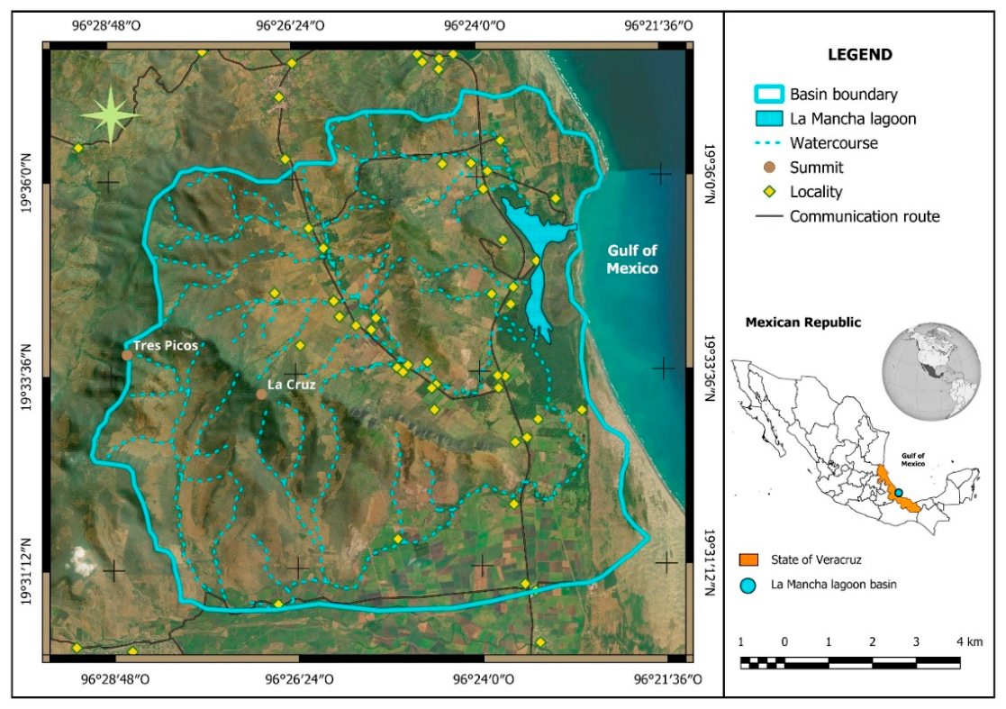
Figure 2.
Land use and vegetation for the years 2000 and 2026 in the La Mancha watershed, Veracruz.
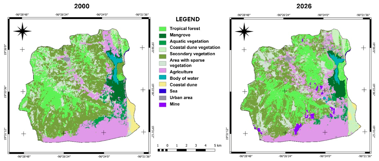
Figure 3.
Persistent areas of the LUV classes from 2000 to 2026 in the La Mancha watershed, Veracruz.
Figure 3.
Persistent areas of the LUV classes from 2000 to 2026 in the La Mancha watershed, Veracruz.
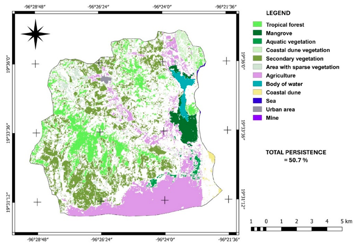
Figure 4.
Main trends in LUV changes between 2000 and 2026 in the La Mancha watershed, Veracruz.
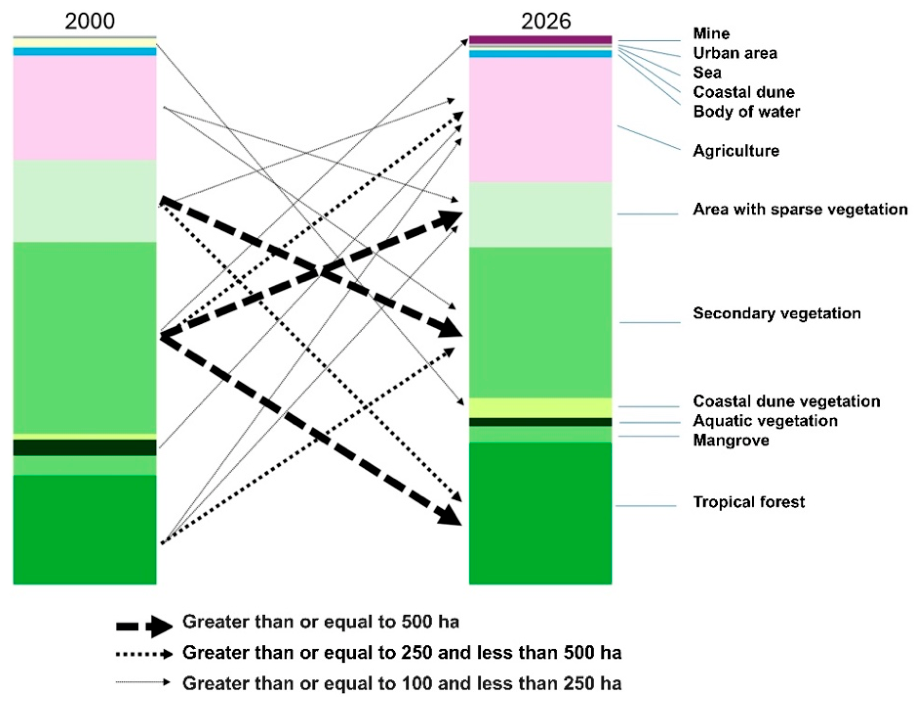
Figure 5.
Dynamics of change among land cover classes in the La Mancha watershed, Veracruz.
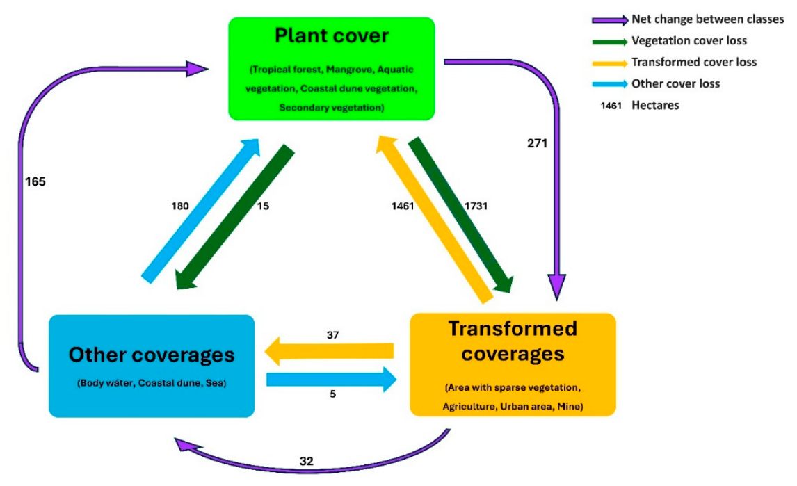
Figure 6.
Relationships between human activities and ecosystem services in the coastal landscape.
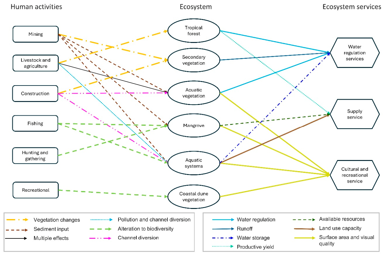
Figure 7.
Interactions among landscape stakeholders based on the use of ecosystem services and socio-ecological impact capacity.
Figure 7.
Interactions among landscape stakeholders based on the use of ecosystem services and socio-ecological impact capacity.
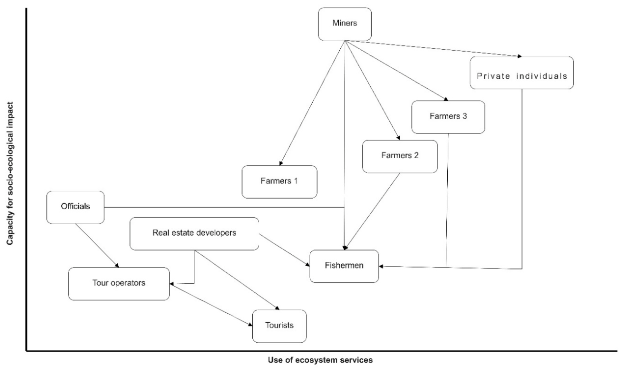

Table 1.
Area and change values between 2000 and 2026 for the La Mancha watershed, Veracruz.
| Class | Year 2000 | Year 2026 | PERSISTENCE | Gains | Losses | Net change | Annual rate | |||
|---|---|---|---|---|---|---|---|---|---|---|
| ha | % | ha | % | ha | % | ha | ha | ha | % | |
| Tropfor | 2198.1 | 19.9 | 2854.1 | 25.8 | 1294.9 | 58.9 | 1559.0 | 903.0 | 656.0 | 1.0 |
| Mangrove | 397.0 | 3.6 | 332.9 | 3.0 | 282.4 | 71.1 | 51.0 | 115.0 | -64.0 | -0.7 |
| Aquaveg | 326.1 | 3.0 | 166.3 | 1.5 | 78.5 | 24.1 | 88.0 | 248.0 | -160.0 | -2.6 |
| Coastdunveg | 112.3 | 1.0 | 399.5 | 3.6 | 86.5 | 77.0 | 313.0 | 26.0 | 287.0 | 5.0 |
| Secveg | 3858.4 | 34.9 | 3032.8 | 27.5 | 1765.5 | 45.8 | 1267.0 | 2093.0 | -826.0 | -0.9 |
| Sparveg | 1656.3 | 15.0 | 1311.0 | 11.9 | 268.5 | 16.2 | 1042.0 | 1388.0 | -346.0 | -0.9 |
| Agriculture | 2101.2 | 19.0 | 2507.3 | 22.7 | 1621.0 | 77.1 | 886.0 | 480.0 | 406.0 | 0.7 |
| Bodywat | 155.7 | 1.4 | 144.7 | 1.3 | 123.8 | 79.5 | 21.0 | 32.0 | -11.0 | -0.3 |
| Coastdune | 193.7 | 1.8 | 70.7 | 0.6 | 39.0 | 20.1 | 32.0 | 155.0 | -123.0 | -3.8 |
| Sea | 7.6 | 0.1 | 8.6 | 0.1 | 7.3 | 96.7 | ||||
| Urbarea | 36.0 | 0.3 | 58.3 | 0.5 | 26.8 | 74.6 | 31.0 | 9.0 | 22.0 | 1.9 |
| Mine | 0.0 | 0.0 | 156.0 | 1.4 | 0.0 | 156.0 | 0.0 | 156.0 | ||
(Tropfor: Tropical forest. Aquaveg: Aquatic vegetation. Coastdunveg: Coastal dune vegetation. Secveg: Secondary vegetation. Sparveg: Area sparse vegetation. Bodywat: Body of water. Coastdune: Coast dune. Urbarea: Urban area).
Disclaimer/Publisher’s Note: The statements, opinions and data contained in all publications are solely those of the individual author(s) and contributor(s) and not of MDPI and/or the editor(s). MDPI and/or the editor(s) disclaim responsibility for any injury to people or property resulting from any ideas, methods, instructions or products referred to in the content. |
© 2026 by the authors. Licensee MDPI, Basel, Switzerland. This article is an open access article distributed under the terms and conditions of the Creative Commons Attribution (CC BY) license (http://creativecommons.org/licenses/by/4.0/).
Copyright: This open access article is published under a Creative Commons CC BY 4.0 license, which permit the free download, distribution, and reuse, provided that the author and preprint are cited in any reuse.