

Submitted:
20 August 2026
Posted:
21 August 2026
You are already at the latest version
Abstract
Wetland vulnerability assessment is essential for identifying interacting pressures, detecting potential changes in ecological character, and supporting adaptive management of Ramsar Sites. This study develops an ecological character-based vulnerability assessment framework and applies it to the Ramsar Site Bau Sau (Crocodile Lake, Ramsar Site No. 1498) in Cat Tien National Park, Vietnam. The framework integrates 26 indicators within six criterion groups and three components: exposure/pressure (E), sensitivity (S), and adaptive capacity/resilience (AC). Indicators were selected to explicitly link climatic, hydrological, ecological, and anthropogenic pressures with the ecosystem components, processes, and functions that define wetland ecological character. The assessment yielded E = 0.500, S = 0.604, and AC = 0.688, resulting in an overall vulnerability index of V = 0.472, classified as moderate. Hydrological variability, inundation dynamics, and hydrological-environmental sensitivity emerged as the principal drivers of vulnerability, whereas relatively strong conservation, management, and monitoring capacity reduced overall vulnerability. The findings indicate that maintaining hydrological processes and ecological character should be central to adaptive management at Bau Sau. More broadly, the proposed framework provides a transparent and adaptable approach for linking Ramsar ecological-character principles with quantitative vulnerability assessment and management prioritization in data-limited wetlands.
Keywords:
wetland vulnerability
; ecological character
; Ramsar Site
; adaptive capacity
; Ramsar Site Bau Sau
1. Introduction
Wetlands are among the most valuable ecosystems for biodiversity conservation, hydrological regulation, water-quality maintenance, carbon storage, and the provision of essential ecosystem services to human societies [1]. At the same time, they are highly sensitive to changes in climate, hydrological regimes, land use, and socioeconomic activities. Interactions between natural and anthropogenic pressures can alter wetland structure, functions, and ecological processes, thereby affecting their capacity to sustain ecosystem services and conservation values [2]. Wetland conservation therefore increasingly requires an approach that goes beyond maintaining wetland area alone and instead focuses on the early detection of ecological change and the enhancement of ecosystem resistance, resilience, and recovery capacity [3].
For wetlands of international importance, the Ramsar Convention places the maintenance of ecological character in close relation to the principle of wise use [4]. Ecological character is expressed through the combination of ecosystem components, processes, and services that characterize a wetland at a given point in time [5]. From this perspective, conserving a Ramsar Site involves more than protecting its boundaries or maintaining its spatial extent; more importantly, it requires sustaining the ecological conditions and processes that underpin the values for which the wetland is recognized. Changes in hydrological regimes, habitats, environmental quality, species composition, or ecosystem functions may therefore provide important signals of changes in ecological character and should be incorporated into wetland management, monitoring, and conservation [6]. The Ramsar framework for wetland inventory, assessment, and monitoring similarly emphasizes the links among identifying ecosystem condition, assessing pressures and risks, monitoring ecological change, and adjusting management responses accordingly [4,6].
Within this context, vulnerability assessment provides a useful approach for determining the extent to which an ecosystem may be affected by pressures and its capacity to resist, adapt to, or recover from their impacts [7,8]. Ramsar Technical Report No. 5 emphasizes that wetland vulnerability assessment should simultaneously consider ecosystem status and trends, drivers and pressures, sensitivity, and adaptive capacity, while also accounting for interactions among multiple pressures rather than examining individual stressors in isolation [7]. This approach is particularly relevant to Ramsar Sites, where hydrological or climatic changes may trigger cascading effects on habitats, biodiversity, and ecosystem services [7,8,9,10,11].
Although wetland vulnerability research has developed various approaches based on risk, exposure, sensitivity, adaptive capacity, and resilience, important gaps remain in translating the Ramsar concept of ecological character into a quantitative assessment framework that can be operationalized at the individual Ramsar-site level [12]. A key challenge is to link external pressures to the ecological components and processes that need to be maintained, while simultaneously incorporating management and recovery capacity into an integrated assessment system [13]. Moreover, long-term monitoring data remain limited and heterogeneous at many wetlands, particularly in developing countries [14]. This creates a need for an assessment framework that is ecologically grounded yet sufficiently flexible to integrate quantitative observations, secondary data, and semi-quantitative indicators while maintaining transparency in the assessment process [15,16,17].
The Ramsar Site Bau Sau (Crocodile Lake in Cat Tien National Park; Ramsar Site No. 1498) provides an appropriate case for testing such an approach [18]. The Bau Sau wetland system and its associated areas comprise ponds, lakes, marshes, streams, and seasonally inundated floodplains, forming a distinctive hydrological-ecological complex in southeastern Vietnam [19,20,21]. The system is characterized by pronounced seasonality, with substantial differences between the area inundated during the wet season and the open-water area persisting through the dry season [20,22]. It also provides important habitat for diverse aquatic organisms and waterbirds and, notably, for the Siamese crocodile (Crocodylus siamensis), a key conservation species of the Ramsar Site [22,23]. Management documents and previous studies indicate that the ecosystem is affected by changes in hydrological regimes, drying trends and declining open-water extent, sedimentation, vegetation succession, invasive species, and pressures associated with buffer-zone and human activities [22]. These interacting changes have the potential to affect habitats, biodiversity, and ecosystem services simultaneously, highlighting the need for an integrated assessment of wetland vulnerability [23].
Bau Sau also presents an important feature for vulnerability research: the wetland is situated within a protected area with a relatively well-established management system. Cat Tien National Park has implemented patrolling, conservation, research, monitoring, and collaborative activities with national and international organizations [20]. Programs supported by WWF and other partners have contributed to ecosystem assessments, threat identification, and management planning for the Bau Sau Ramsar Site [23]. This context makes it possible to assess vulnerability not only in terms of ecological pressures and sensitivity but also through adaptive, management, and recovery capacity, dimensions that are often difficult to quantify in wetland vulnerability studies [24,25,26].
To address these gaps, this study develops an ecological character-based vulnerability assessment framework for Ramsar wetlands and applies it to the Bau Sau Ramsar Site. The framework integrates three components: Exposure/Pressure (E), Sensitivity (S), and Adaptive Capacity/Resilience (AC). Unlike approaches that primarily aggregate individual threats, the indicators are selected and interpreted according to their relationships with the ecosystem components, processes, and functions that constitute wetland ecological character. The assessment therefore aims not only to determine the overall level of vulnerability but also to identify the mechanisms and factors that shape it, thereby providing a basis for prioritizing monitoring, conservation, ecological restoration, and adaptive management.
Specifically, the study addresses three research questions: (1) Which ecological, hydrological, climatic, and anthropogenic factors are the principal contributors to the vulnerability of the Bau Sau Ramsar Site? (2) How can these factors be integrated into a vulnerability assessment framework centered on maintaining the ecological character of a Ramsar Site? (3) What does application of the framework to Bau Sau reveal about its overall vulnerability, key drivers, and management priorities? Through the Bau Sau case study, this research seeks to provide an assessment approach that can be further tested and refined to support vulnerability assessment and adaptive management in other Ramsar Sites and wetlands with comparable ecological conditions.
2. Study Area and Methods
2.1. Study Area
The study focuses on the vulnerability of the wetland ecosystem of Ramsar Site Bau Sau, examined in relation to wetland condition and ecological character, natural, environmental, and anthropogenic pressures, and the adaptive capacity, resilience, and recovery potential of the system.
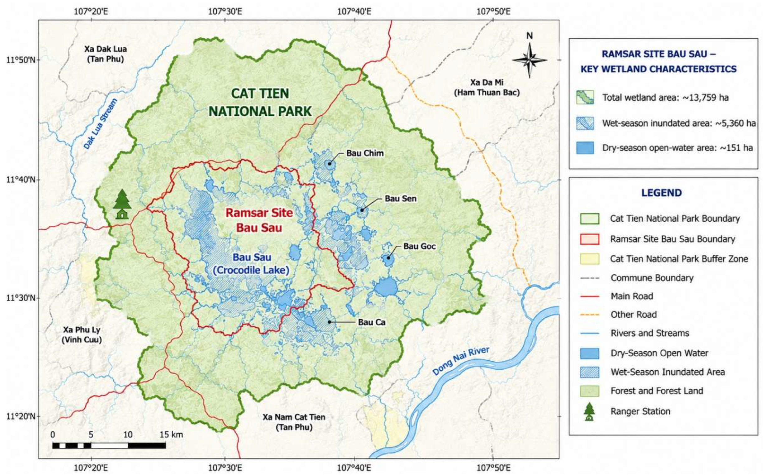
Ramsar Site Bau Sau was designated as Vietnam’s second Ramsar Site in 2005 [7]. The Bau Sau wetland system covers approximately 13,759 ha, of which about 5,360 ha are inundated during the wet season, while approximately 151 ha remain as open water during the dry season [19]. The system comprises ponds, lakes, marshes, depressions, streams, and seasonally inundated grasslands. Bau Sau, together with Bau Chim, Bau Sen, Bau Goc, and Bau Ca, forms a wetland habitat complex characterized by spatial differences in inundation extent and duration [21].
The central area of Bau Sau retains relatively stable open water, whereas Bau Chim, Bau Sen, Bau Goc, Bau Ca, and adjacent low-lying areas are predominantly seasonally inundated and become more hydrologically connected during the wet season [19]. The wetland system is also hydrologically associated with Dak Lua Stream and floodplain areas adjacent to the Dong Nai River. Consequently, variations in rainfall, streamflow, inundation duration, and inundation frequency can alter open-water extent, seasonally inundated zones, and habitat structure [21]. The pronounced seasonal contrast between the wet and dry seasons therefore makes hydrological dynamics a central component in assessing the ecological sensitivity of Ramsar Site Bau Sau [26].
In terms of biodiversity, Bau Sau provides important habitat for aquatic organisms, waterbirds, reptiles, and other wildlife of high conservation significance. Of particular importance is the Siamese crocodile (Crocodylus siamensis), a Critically Endangered (CR) species, together with the Asian arowana (Scleropages formosus), lesser adjutant (Leptoptilos javanicus), and numerous waterbird species [18]. Ramsar Site Bau Sau meets Ramsar criteria related to the representativeness and ecological significance of tropical freshwater wetland ecosystems [19]. The wetland also provides multiple ecosystem services and supports scientific research, environmental education, and ecotourism [21].
These characteristics indicate that Bau Sau is a highly dynamic wetland ecosystem in which hydrological processes, habitat conditions, biodiversity, ecosystem services, and activities in the surrounding buffer zone are closely interconnected [22]. These interactions provide the ecological basis for selecting Ramsar Site Bau Sau as a case study for applying an integrated vulnerability assessment framework rather than assessing individual stressors in isolation.
Figure 1.
Location of Ramsar Site Bau Sau (Crocodile Lake) within Cat Tien National Park, Vietnam. (Source: Adapted from the Ecotourism Development Scheme of Cat Tien National Park [22]).
Figure 1.
Location of Ramsar Site Bau Sau (Crocodile Lake) within Cat Tien National Park, Vietnam. (Source: Adapted from the Ecotourism Development Scheme of Cat Tien National Park [22]).
2.2. Data Sources and Assessment Framework
The study integrated primary field data, site-specific secondary data, and regional and national reference information to construct and quantify the vulnerability indicators. The data sources were organized according to their relevance to Ramsar Site Bau Sau and the strength of the supporting evidence.
Primary data from Ramsar Site Bau Sau were collected through four field surveys conducted in 2025 and 2026, covering both major hydrological seasons. In each year, field surveys were undertaken during the dry season (April-June) and the wet season (September-October) to capture seasonal variability in wetland conditions [27]. Field observations and survey data covered wetland condition, habitat characteristics, inundation patterns, open-water extent, habitat change, environmental quality, biodiversity, and major natural and anthropogenic pressures affecting the wetland ecosystem [27]. This two-year, seasonally structured survey design was particularly important given the pronounced wet-dry hydrological dynamics of Bau Sau and provided the primary empirical basis for quantifying indicators related to Exposure/Pressure (E) and Sensitivity (S).
Figure 2.
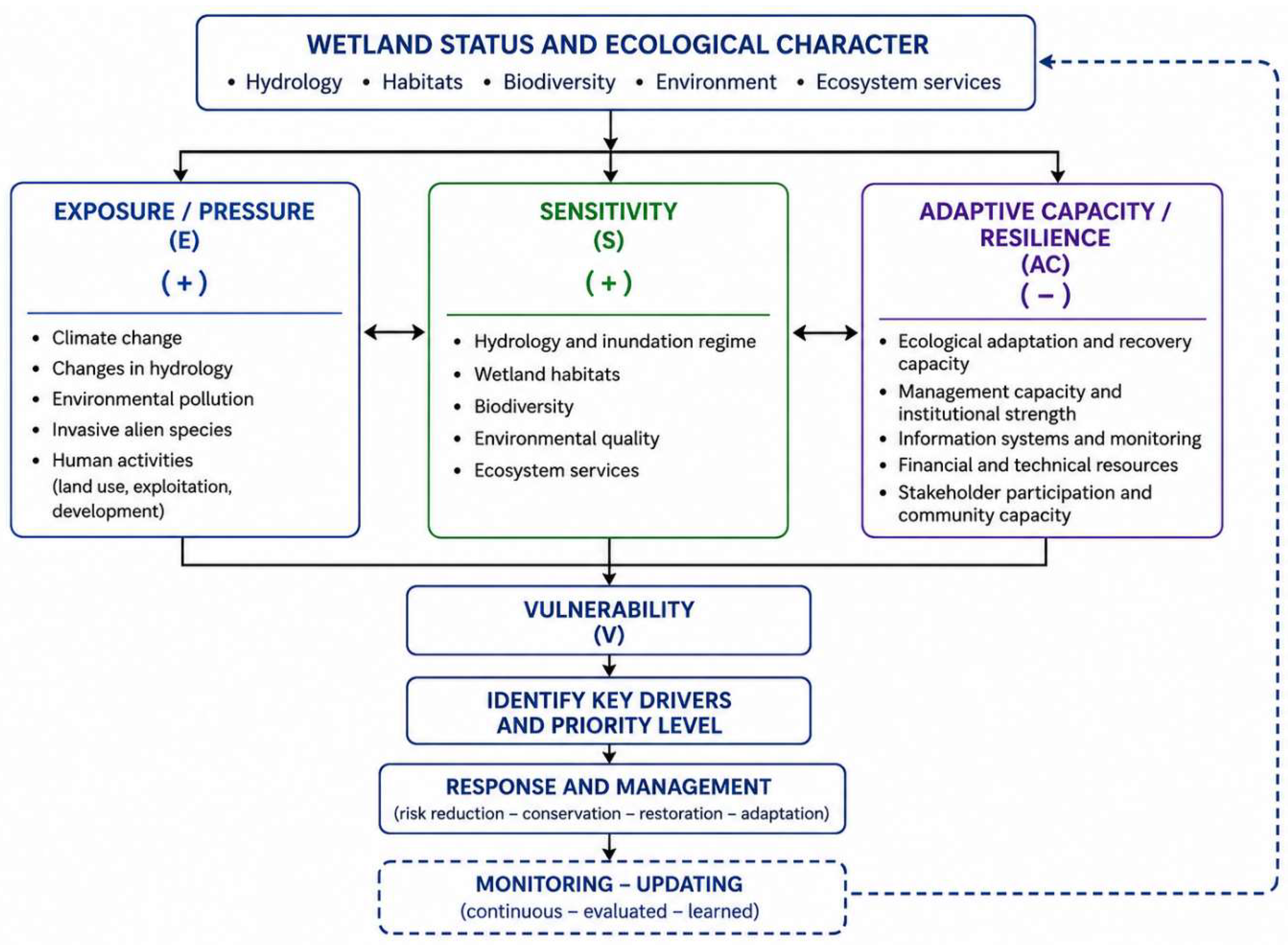
Wetland vulnerability assessment framework applied to Ramsar Site Bau Sau. (Source: Developed by the authors based on the Ramsar wetland vulnerability assessment framework [6,9]).
Site-specific secondary data included the Ramsar Site documentation, management records and technical reports of Cat Tien National Park, outputs from WWF/USAID and GIZ/SFMP programs, and previous studies conducted within Cat Tien National Park [9,10,11]. Management documents from Cat Tien National Park [19,20,21,25,26] provided additional information on institutional arrangements, patrolling and protection activities, buffer-zone communities, conservation financing, tourism, and stakeholder coordination. These sources were particularly important for assessing Adaptive Capacity/Resilience (AC), including management capacity, monitoring, ecological recovery, and stakeholder participation [28,29].
Regional and national reference data were used to characterize broader trends, identify reference thresholds, and support interpretation of indicators for which long-term site-specific observations were unavailable. The National Ecosystem Assessment Report of Vietnam provided a DPSIR/IPBES-based framework linking drivers, pressures, ecosystem condition, ecosystem services, and management responses [5,19,20,21,22,23,24,25,26,30,31], while the Vietnam National Biodiversity Report provided reference information on major pressures affecting wetland ecosystems [1].
To account for differences in data availability and quality, the evidence underlying each indicator was classified according to an evidence hierarchy. Direct observations and measurements from Ramsar Site Bau Sau were assigned the highest priority, followed by data with direct spatial and ecological relevance from Cat Tien National Park and the Dong Nai Biosphere Reserve, and subsequently by other secondary sources and semi-quantitative assessments. Where complete monitoring time series were unavailable, controlled interpolation or evidence-based semi-quantitative scoring was applied only when supporting information on ecosystem condition, trends, or plausible impact mechanisms was available. This evidence hierarchy was also considered when assessing the confidence associated with individual indicators and when interpreting the overall vulnerability results.
The framework provides the methodological basis for selecting, standardizing, weighting, and aggregating vulnerability indicators in relation to the ecological character of Ramsar Site Bau Sau, while accounting for site-specific data availability and evidence quality.
2.3. Development of the Criteria, Indicators, and Assessment Method
The vulnerability assessment criteria and indicators were developed using an integrated approach combining the Ramsar framework [3,7], Vietnamese regulations on wetland conservation and wise use [2], the DPSIR/IPBES framework [5], and the ecological characteristics and available data of Ramsar Site Bau Sau [19,20,21,22,23,24,25,26].
Following the screening process, 26 indicators grouped into six criterion groups were selected and organized within the three E-S-AC components (Table 1).
Data for each indicator were assigned according to the strength of supporting evidence, with priority given sequentially to direct data from Ramsar Site Bau Sau; data from Cat Tien National Park and the Dong Nai Biosphere Reserve with direct spatial or ecological relevance to the site; and evidence-based semi-quantitative assessments derived from management records and field surveys. All indicators were standardized to a 0-1 scale to ensure comparability. Continuous quantitative variables were normalized using their observed ranges or appropriate reference thresholds.
For semi-quantitative indicators, the supporting evidence was classified into five levels, corresponding to standardized scores of 0, 0.25, 0.50, 0.75, and 1.00. The direction of influence was defined separately for each indicator. Higher standardized values represented greater contributions to Exposure/Pressure (E) or Sensitivity (S), whereas higher values for Adaptive Capacity/Resilience (AC) represented stronger adaptive and recovery capacity.
Equal weighting was applied to minimize subjective differentiation among indicators in the absence of sufficient empirical evidence to support differential weights. Indicator scores were first aggregated within each criterion group and subsequently across the E, S, and AC components. This weighting assumption was adopted for the baseline assessment and is further considered in the limitations of the study [6]
Where:
: component E, S or AC;
: the weight assigned to indicator j
Xj′ : he standardized value of indicator j.
Based on the principle that E and S increase vulnerability, whereas AC reduces vulnerability, the overall vulnerability index (V) was calculated as follows [6]:
The transformation (1−AC) converts adaptive capacity into an adaptive-capacity deficit, thereby ensuring that all three terms in Equation (2) have the same direction of influence, with higher values consistently indicating greater vulnerability [7].
3. Results
3.1. Vulnerability Context of Ramsar Site Bau Sau
Ramsar Site Bau Sau is a highly seasonal freshwater wetland system in which hydrological dynamics play a dominant role in shaping habitat structure, biodiversity, and ecosystem functions [21]. Synthesis of documentary evidence, field survey results, and remote-sensing data indicates that the wetland continues to maintain its characteristic ecological values, while showing notable changes in inundation dynamics, open-water extent, habitat conditions, and biological components [8]. These changes provide important evidence for characterizing the vulnerability context of the site and for structuring the indicator-based assessment.
Hydrological variability and drying trends: the inundated area of Bau Sau varies substantially between seasons. During the wet season, inundation may extend over approximately 5,360 ha, whereas persistent open-water area contracts markedly during the dry season. Remote-sensing analyses and previous studies indicate temporal fluctuations and declining open-water extent during certain periods [20]. Water exchange between the Bau Sau wetland complex and the Dong Nai River through Dak Lua Stream has also shown signs of reduced connectivity, potentially increasing the duration of dry conditions and altering the natural inundation regime [20].
Habitat change and wetland succession: in some areas, organic-matter accumulation, sedimentation, and the expansion of vegetation in seasonally inundated zones have contributed to the contraction of open-water habitats and promoted transitions from open-water environments toward marsh or relatively drier habitat conditions. Organic deposits recorded at surveyed locations ranged from approximately 1 to 34 cm in thickness [23]. The occurrence of invasive alien plants, particularly Mimosa pigra, together with the expansion of some aquatic and semi-aquatic plant communities, represents an additional pressure on habitat structure. However, the available evidence does not support attributing the observed reduction in open-water extent to any single driver [25].
Biodiversity and wetland-dependent species: these hydrological and habitat changes may affect biodiversity and species that depend on wetland conditions. Field surveys at Bau Sau recorded 41 waterbird species belonging to 14 families, together with diverse aquatic biota [20]. These observations confirm the site’s high conservation value while also indicating the potential sensitivity of wetland-dependent biological communities to changes in water levels, open-water extent, inundation patterns, and habitat structure.
Anthropogenic pressures from the surrounding buffer zone: Human-related pressures include agricultural activities, fertilizer and pesticide use, natural-resource extraction, fishing, and tourism [21]. Their magnitude and spatial influence are heterogeneous, and some pressures have been reduced by the protection and management mechanisms of Cat Tien National Park [19]. Management records indicate that ranger patrols, community engagement, and coordination among relevant stakeholders have contributed to reducing violations and strengthening the capacity to control direct pressures on the wetland [32,33,34,35].
Taken together, these findings indicate that the vulnerability of Ramsar Site Bau Sau arises from the interaction of hydrological and climatic variability, habitat and environmental change, biological responses, anthropogenic pressures, and management capacity. Simultaneous quantification of Exposure/Pressure (E), Sensitivity (S), and Adaptive Capacity/Resilience (AC) is therefore required to determine the overall vulnerability level and identify the factors that most strongly influence vulnerability at the site.

Table 3.
Major factors contributing to the vulnerability of Ramsar Site Bau Sau.
| Factor group | Main manifestations | Potential ecosystem effects | Relationship with vulnerability |
|---|---|---|---|
| Climate and hydrology | Variability in inundation regime; declining open-water extent; drying of seasonally inundated areas; changes in water exchange | Alteration of the fundamental hydrological conditions of the wetland | Increases exposure and sensitivity |
| Habitat and environmental conditions | Contraction of open-water habitats; sedimentation and organic-matter accumulation; habitat change; potential deterioration of water quality | Reduced water volume and changes in ecosystem structure and functions | Increases sensitivity |
| Biological factors | Expansion of grass-dominated vegetation; occurrence of Mimosa pigra; changes in habitats of wetland-dependent species | Changes in community structure, food resources, and habitat availability | Increases ecological sensitivity |
| Anthropogenic pressures | Buffer-zone pressures; resource extraction; production and domestic activities; tourism; fire risk | Direct pressures and amplification of natural stressors | Increases exposure |
| Management and response capacity | Patrolling, conservation, and monitoring; community participation; support from conservation programs and projects | Reduces pressures and strengthens response and recovery capacity | ncreases adaptive capacity |
(Source: Authors’ synthesis based on field surveys and supporting evidence).
3.2. Vulnerability Across Assessment Dimensions
Application of the ecological character-based assessment framework to Ramsar Site Bau Sau resulted in 26 indicators grouped into six criterion groups, representing the three major dimensions of vulnerability: Exposure/Pressure (E), Sensitivity (S), and Adaptive Capacity/Resilience (AC). The indicator system captures processes that may influence the ecological character of the wetland, ranging from climate-hydrological variability and anthropogenic pressures to responses in hydrology, habitats, biodiversity, ecosystem services, and management and recovery capacity.
Of the 26 indicators, eight were assigned to E, ten to S, and eight to AC. This structure reflects the conceptual basis of the framework: vulnerability is determined not only by the magnitude of external pressures but also by how ecological components and processes respond to those pressures and by the capacity of the ecosystem and management system to adapt, mitigate impacts, and recover. The complete indicator system, supporting evidence, standardized scores, and confidence levels (Table 4).
1) Exposure/Pressure
The aggregated Exposure/Pressure score was E = 0.500, indicating an overall moderate level of pressure. However, the two constituent criterion groups differed substantially. Climate-hydrological pressures and natural variability (TC1 = 0.625) were considerably higher than anthropogenic pressures and threats (TC2 = 0.375).
At the indicator level, changes in the inundation regime (E1.2 = 0.75) and reduced hydrological exchange and water replenishment (E1.3 = 0.75) made the largest contributions to E. In contrast, illegal resource extraction and wildlife use (E2.2 = 0.25) and tourism pressure (E2.3 = 0.25) received lower scores. These results indicate that the current exposure profile of Bau Sau is characterized more strongly by hydrological and climate-related processes than by direct anthropogenic pressures, although diffuse pressures from the surrounding buffer zone remain relevant.
2) Sensitivity
Sensitivity was S = 0.604, representing the strongest vulnerability-increasing component. Both hydrological and environmental sensitivity (TC3 = 0.625) and biodiversity, habitat, and ecosystem-service sensitivity (TC4 = 0.583) contributed substantially to this result.
Within TC3, sensitivity of open-water extent (S3.1 = 0.75) and seasonally inundated habitats to drying (S3.2 = 0.75) received the highest scores. Within TC4, changes in wetland habitat structure (S4.1 = 0.75) and sensitivity of Siamese crocodile habitat (S4.2 = 0.75) were particularly important. The results therefore indicate that sensitivity at Bau Sau is not concentrated in a single ecological component but emerges from the interconnected response of hydrology, open-water extent, habitat structure, and wetland-dependent biodiversity.
3) Adaptive Capacity/Resilience
The aggregated Adaptive Capacity/Resilience score was AC = 0.688, exceeding both E and S. Conservation, management, and monitoring capacity (TC5 = 0.750) had the highest score among all six criterion groups, whereas ecological recovery, adaptation, and stakeholder participation (TC6 = 0.625) was somewhat lower.
The relatively high TC5 score reflects the advantages associated with Bau Sau’s location within Cat Tien National Park, where formal protection, ranger patrols, conservation activities, research, monitoring, institutional support, and conservation partnerships are well established. However, the lower TC6 score indicates an important distinction: institutional and management capacity appears stronger than the demonstrated capacity to restore hydrological and ecological processes. Thus, a relatively strong management system does not necessarily imply equally strong ecological recovery capacity.
Table 5.
Vulnerability assessment results across components and indicator groups.
| Component | Group | Group score | Component score | Interpretation |
|---|---|---|---|---|
| E | TC1 - Climate-hydrological pressures and natural variability | 0.625 | 0.500 | Relatively high |
| TC2 - Anthropogenic pressures and threats | 0.375 | Moderate | ||
| S | TC3 - Hydrological and environmental sensitivity | 0.625 | 0.604 | Relatively high |
| TC4 - Biodiversity, habitat, and ecosystem-service sensitivity | 0.583 | Moderate-relatively high | ||
| AC | TC5 - Conservation, management, and monitoring capacityTC5 | 0.750 | 0.688 | High capacity |
| TC6 - Ecological recovery, adaptation, and stakeholder participation | 0.625 | Relatively high capacity |
(Source: Authors’ calculations).
V=30.500+0.604+(1−0.688) =0.472
According to the five-level classification scheme, V = 0.472 corresponds to moderate vulnerability. The value lies near the middle of the moderate range (0.40-<0.60), rather than close to either the low or high vulnerability threshold.
Importantly, however, the aggregate index masks substantial differences among its underlying dimensions. Sensitivity (S = 0.604) already exceeds the 0.60 threshold, while the relatively high adaptive capacity (AC = 0.688) reduces the overall index through an adaptive-capacity deficit of only 1 − AC = 0.312. The moderate overall vulnerability of Ramsar Site Bau Sau therefore results from the coexistence of relatively high ecological sensitivity and comparatively strong conservation and management capacity. Accordingly, V = 0.472 should not be interpreted as indicating that all ecological components of Bau Sau experience only moderate vulnerability.
4. Discussion
4.1. Key Drivers and Mechanisms of Vulnerability in the Bau Sau Ramsar Wetland
The results indicate that the vulnerability of Ramsar Site Bau Sau is not determined by a single pressure but emerges from the interaction among hydrological variability, ecosystem sensitivity, and ecological recovery capacity. This pattern is consistent with the broader understanding of wetland vulnerability as a multidimensional process in which multiple stressors interact with the sensitivity and adaptive capacity of ecological systems. The Ramsar vulnerability framework similarly emphasizes that pressures should not be considered in isolation, but rather in relation to the ecological components and processes through which changes in ecological character may occur.
From an ecological perspective, the vulnerability structure identified for Bau Sau can be interpreted as a cascading pathway: climate-hydrological variability → changes in inundation regime and open-water extent → habitat transformation → effects on biodiversity and ecosystem services → increased vulnerability.
In the opposite direction, conservation, management, monitoring, and stakeholder participation provide a compensatory mechanism by strengthening adaptive capacity and reducing overall vulnerability. This interaction is particularly important for interpreting the moderate overall vulnerability index: the current condition of Bau Sau reflects not an absence of ecological stress, but rather the coexistence of substantial ecological sensitivity and relatively strong management capacity.
Figure 3.
Vulnerability structure across the six criterion groups of Ramsar Site Bau Sau.
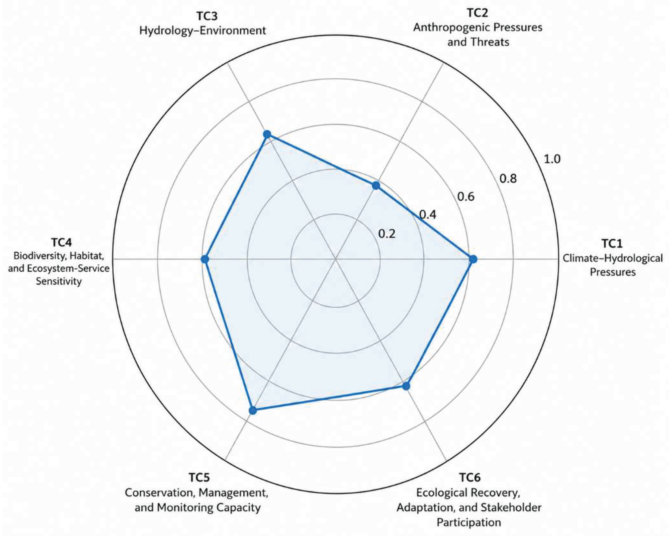
Hydrology emerges as the central mechanism shaping vulnerability. The identical scores for climate-hydrological pressures (TC1 = 0.625) and hydrological-environmental sensitivity (TC3 = 0.625) indicate that the water regime operates simultaneously as a source of pressure and as a major determinant of ecosystem response. This is consistent with the ecological functioning of seasonal wetlands, where hydroperiod, hydrological connectivity, and water availability regulate the spatial and temporal distribution of aquatic and semi-aquatic habitats. Changes in these processes may therefore propagate beyond the physical contraction of open water and affect habitat configuration, ecological connectivity, species assemblages, and ecosystem functions.
This mechanism is particularly relevant to Bau Sau because of its pronounced seasonal hydrological dynamics. Changes in the timing, duration, frequency, and spatial extent of inundation, together with reduced water replenishment and connectivity, may generate cascading effects along the pathway water regime → habitat structure → biodiversity → ecosystem functions. Consequently, changes in open-water extent should not be interpreted merely as physical changes in wetland area; rather, they may represent an early signal of broader changes in ecological character. This interpretation is consistent with the Ramsar perspective, in which changes in ecological character arise through alterations in the components, processes, and ecosystem services that define a wetland.
The relatively high sensitivity of biodiversity and habitats should therefore not be interpreted independently of hydrological change. Wetland-dependent species, including the Siamese crocodile (Crocodylus siamensis), waterbirds, fish, and other aquatic biota, respond directly or indirectly to changes in water levels, inundation duration, habitat connectivity, and habitat structure. In this sense, biodiversity sensitivity represents not only a separate dimension of vulnerability but also an ecological expression of changes occurring within the hydrological-habitat system. This linkage helps explain why TC4 remained relatively high (0.583), even though direct anthropogenic pressures were comparatively lower.
Another important finding is that direct anthropogenic pressures were lower than climate-hydrological pressures (TC2 = 0.375 versus TC1 = 0.625). This pattern is consistent with the protected-area context of Bau Sau, where ranger patrols, access regulation, conservation programs, and stakeholder coordination have reduced several forms of direct human disturbance. However, protection status cannot fully buffer a wetland against climatic variability, hydrological alteration, catchment-scale processes, or slow ecological transitions. The results therefore illustrate an important distinction between controlling proximate anthropogenic pressures and addressing the broader processes that influence wetland ecological character.
A particularly relevant finding is that management capacity does not necessarily translate into equivalent ecological recovery capacity. Conservation, management, and monitoring capacity (TC5 = 0.750) was the highest-scoring criterion group, whereas ecological recovery, adaptation, and stakeholder participation (TC6 = 0.625) was lower. This difference suggests that institutional protection can effectively reduce direct pressures and improve monitoring and management responses, while ecological processes such as hydrological alteration, sediment accumulation, habitat succession, and invasive-species dynamics may remain difficult to reverse. In other words, strong governance can reduce vulnerability, but it cannot automatically restore ecological resilience.
Taken together, these findings suggest that vulnerability at Ramsar Site Bau Sau should be understood as a coupled hydrological-ecological-management process rather than as the cumulative effect of independent threats. The relatively strong management system currently provides an important buffer against vulnerability, but the persistence of hydrological and habitat sensitivity indicates that long-term conservation will increasingly depend on maintaining the ecological processes underlying the site’s ecological character. This shifts the management emphasis from protection and violation control alone toward hydrological management, ecological monitoring, habitat restoration, and the strengthening of ecosystem recovery capacity.
4.2. Implications for Maintaining the Ecological Character of Ramsar Wetlands
An important contribution of this study is the explicit linkage of vulnerability assessment to the Ramsar concept of ecological character. From this perspective, the key management question is not simply how many or how intense the pressures affecting a Ramsar Site are, but rather whether and through what pathways those pressures may alter the ecosystem components, processes, and services that constitute its ecological character. This approach moves ecological character beyond a primarily descriptive concept and uses it as an organizing basis for indicator selection, identification of impact pathways, and assessment of vulnerability.
Ramsar Site Bau Sau illustrates the value of this approach. If the assessment were restricted to external pressures, the relatively low score for direct anthropogenic pressures (TC2 = 0.375) might suggest that the wetland is comparatively well protected. However, incorporating ecosystem sensitivity reveals a more complex vulnerability structure. Hydrological variability, changes in open-water extent, and habitat responses remain important even where direct human pressures are relatively well controlled. Thus, a Ramsar Site may be effectively protected against direct disturbances while its ecological character remains vulnerable to hydrological and ecological processes that are more difficult to control.
This finding also has implications for Ramsar monitoring. Monitoring systems should extend beyond indicators of wetland area or the presence of selected flagship species to include variables that can detect changes in the processes sustaining ecological character. At Bau Sau, variables such as hydroperiod, hydrological connectivity, open-water extent, habitat transitions, and responses of ecological indicator species are particularly relevant because they can reveal changes in the hydrological-ecological system before more pronounced ecological degradation becomes evident. When monitored together with indicators of external pressures and recovery capacity, these variables may provide an early-warning basis for detecting potential changes in ecological character and enable management responses before such changes become difficult to reverse.
From a methodological perspective, the E-S-AC framework developed in this study is not intended to replace the Ramsar framework for wetland inventory, assessment, and monitoring. Rather, its value lies in providing a complementary structure through which components of ecological character can be linked to factors that increase or reduce vulnerability and subsequently expressed in a quantitative assessment. In this sense, Exposure/Pressure identifies the forces acting on the wetland; Sensitivity captures how the components and processes underlying ecological character may respond; and Adaptive Capacity/Resilience represents the capacity of the ecological and management systems to absorb, respond to, or recover from those impacts.
Such an approach may be particularly useful for Ramsar Sites where monitoring data are fragmented, heterogeneous, or insufficient to establish long-term time series. By combining quantitative observations with systematically documented evidence and semi-quantitative indicators, the framework enables available information to be incorporated into a transparent assessment structure. However, this flexibility depends on explicit documentation of data sources, scoring procedures, evidence quality, and uncertainty. The resulting vulnerability index should therefore be interpreted not as a substitute for long-term ecological monitoring, but as a decision-support tool for identifying vulnerable components, prioritizing monitoring needs, and directing conservation and restoration efforts toward the processes most critical for maintaining ecological character.
4.3. Implications for Adaptive Management and Wetland Conservation
The findings suggest that management of Ramsar Site Bau Sau should evolve from an approach focused primarily on controlling direct pressures toward one that combines site protection with the maintenance of ecological processes and enhancement of ecosystem recovery capacity. This does not diminish the importance of existing conservation and enforcement measures; rather, it extends management attention to the processes that sustain the ecological character of the wetland.
First, hydrological monitoring should be a central management priority. A long-term monitoring program should integrate rainfall, water levels, inundation timing and duration, inundation extent, dry-season open-water extent, hydrological connectivity, and associated habitat changes. These variables should be analyzed as an interconnected hydrological-ecological system rather than as separate datasets. Such integration would improve the capacity to distinguish natural seasonal variability from persistent directional change and to identify hydrological alterations that may affect ecological character.
Second, adaptive management would benefit from the development of ecological early-warning indicators. For Bau Sau, priority variables could include anomalous changes in dry-season open-water extent, inundation duration, rates of transition from open water to vegetated habitats, sediment accumulation, and the condition and availability of suitable habitat for the Siamese crocodile. Rather than relying on single fixed thresholds, these indicators could initially be evaluated against site-specific ranges of natural or acceptable ecological variability. Persistent departures from these ranges could then trigger further investigation of underlying causes and, where necessary, targeted management interventions. Establishing such thresholds will require longer monitoring time series and empirical validation.
Third, management should explicitly distinguish between management capacity and ecological recovery capacity. The relatively strong capacity for patrolling, protection, monitoring, and institutional coordination at Bau Sau should be maintained, but additional conservation efforts should increasingly address the ecological processes that are more difficult to restore. These include maintaining or restoring hydrological connectivity, managing sediment accumulation and undesirable vegetation succession, controlling invasive species, restoring critical habitats, and strengthening ecosystem resilience to climatic extremes. This reflects the iterative logic of adaptive management:
monitor → evaluate → respond → learn → adjust management.
Under this approach, monitoring is not an end in itself but a mechanism for continuously updating management decisions as ecological conditions and knowledge of the system change.
Finally, Bau Sau represents a single case study with a distinctive ecological setting and a relatively well-established protected-area management system. The transferability of the present study therefore does not lie in applying the same 26 indicators, weights, scores, or classification outcomes unchanged to other Ramsar Sites. Rather, the principal transferable contribution is the analytical logic linking: ecological character → E-S-AC → vulnerability → adaptive management.
Within this structure, the specific indicators and reference conditions should be adapted to the ecological characteristics, dominant pressures, management context, and data availability of each wetland. Testing the framework across different wetland types-including freshwater wetlands, floodplains, mangroves, estuarine systems, and coastal Ramsar Sites-would help distinguish indicators that are broadly applicable from those requiring ecosystem-specific adaptation. Comparative applications would also provide an empirical basis for evaluating the robustness, sensitivity, and broader applicability of the proposed framework.
4.4. Limitations and Future Research
Several limitations should be considered when interpreting the results of this study.
First, the evidence supporting the 26 indicators was heterogeneous in temporal coverage, spatial resolution, and degree of directness. While several indicators were supported by quantitative evidence from field surveys, GIS/remote-sensing analyses, and monitoring records, others-particularly those related to ecological recovery capacity, governance, and stakeholder participation-relied partly on secondary evidence and semi-quantitative scoring. Consequently, the overall vulnerability index (V = 0.472) should be interpreted as a baseline vulnerability estimate under the available evidence rather than as an absolute or temporally invariant measure of vulnerability. Future assessments based on longer and more consistent monitoring time series would allow the index to be updated and changes in vulnerability to be evaluated more robustly.
Second, the use of equal weighting reduced the degree of subjective differentiation among indicators where the available evidence was insufficient to justify alternative weights. However, the assumption that indicators contribute equally to their respective assessment dimensions may simplify the ecological relationships underlying vulnerability. Future research should compare equal weighting with alternative approaches based on expert elicitation, multi-criteria decision analysis, or empirical data. Sensitivity and uncertainty analyses should also be conducted to determine how changes in indicator scores, weights, normalization procedures, and classification thresholds affect the resulting E, S, AC, and overall vulnerability estimates.
Third, the present assessment treats Ramsar Site Bau Sau as an integrated system at the site scale and therefore does not fully capture the spatial heterogeneity of vulnerability among open-water areas, seasonally inundated zones, satellite wetlands, hydrological connections, and transition areas adjoining the buffer zone. Integrating long-term remote-sensing time series with water-level observations, hydrological modelling, habitat data, and biological indicators could enable the development of spatially explicit vulnerability assessments. Such an approach would make it possible to identify vulnerability hotspots and determine whether different parts of the wetland are responding differently to hydrological, ecological, and anthropogenic pressures.
Finally, Ramsar Site Bau Sau represents a single case study with distinctive ecological characteristics and a specific protected-area governance context. The 26 indicators, their scoring criteria, and associated thresholds should therefore not be transferred unchanged to other Ramsar Sites. The broader applicability of this study lies primarily in the logic of the assessment framework-
ecological character → E-S-AC → vulnerability → adaptive management
-rather than in a fixed indicator set. Testing and refining the framework across contrasting wetland types, including freshwater lakes and marshes, floodplains, estuarine wetlands, mangroves, and other coastal wetlands, will be necessary to distinguish broadly transferable elements from ecosystem-specific indicators. Comparative applications across multiple Ramsar Sites would further allow the robustness, transferability, and potential for cross-site comparison of the framework to be evaluated.
5. Conclusions
This study developed and applied an ecological character-based vulnerability assessment framework to Ramsar Site Bau Sau, Vietnam. The framework integrates Ramsar principles with three vulnerability dimensions-Exposure/Pressure (E), Sensitivity (S), and Adaptive Capacity/Resilience (AC)-thereby linking external stressors to the ecological components, processes, and functions that underpin the ecological character of the wetland. The assessment comprised 26 indicators organized into six criterion groups, allowing quantitative data to be combined with systematically documented semi-quantitative evidence where consistent long-term monitoring data were unavailable.
Application of the framework resulted in E = 0.500, S = 0.604, and AC = 0.688, yielding an overall vulnerability index of V = 0.472, classified as moderate vulnerability. However, the aggregate value alone does not fully represent the internal structure of vulnerability. At the criterion-group level, climate-hydrological pressures (TC1 = 0.625) and hydrological-environmental sensitivity (TC3 = 0.625) emerged as particularly important, identifying the water regime as a central mechanism shaping vulnerability at Bau Sau. Changes in inundation regime, open-water persistence, and hydrological connectivity may propagate through the wetland system, affecting habitat structure, biodiversity, and ecosystem functions. Conversely, relatively strong conservation, management, and monitoring capacity contributes to reducing overall vulnerability, although such institutional capacity does not necessarily translate into an equivalent capacity for restoring hydrological and ecological processes.
These findings suggest that conservation of Ramsar Site Bau Sau should extend beyond controlling direct anthropogenic pressures toward maintaining the processes that sustain ecological character and strengthening ecosystem resilience. Priority should be given to integrated monitoring of hydrological conditions, open-water extent, habitat transitions, and ecological indicator species. Over time, these observations could support the development and validation of site-specific ecological early-warning thresholds, enabling management responses to be initiated before ecological changes become difficult to reverse. Maintaining hydrological connectivity, managing undesirable vegetation succession and invasive species, restoring critical habitats, and strengthening stakeholder participation should therefore form part of an adaptive management approach.
More broadly, the principal contribution of this study lies not in proposing a universally fixed set of indicators, but in establishing a transferable analytical logic linking ecological character → E-S-AC → vulnerability → adaptive management. Given the heterogeneity of the underlying evidence, V = 0.472 should be regarded as a baseline vulnerability estimate rather than an absolute measure. Further testing across different wetland types, together with longer-term monitoring and sensitivity and uncertainty analyses, will be necessary to evaluate and refine the framework for wider application to Ramsar wetlands.
Author Contributions
Conceptualization, D.N.D.; methodology, D.N.D.; investigation, D.N.D.; formal analysis, D.N.D.; data curation, D.N.D.; writing—original draft preparation, D.N.D.; writing—review and editing, D.N.D.; visualization, D.N.D.; project administration, D.N.D. The author has read and agreed to the published version of the manuscript.
Funding
This research was funded by the Ministry of Agriculture and Environment of Vietnam through the research project entitled “Investigation and Assessment of the Current Status and Development of Criteria for Assessing the Vulnerability of Important Inland Wetlands in Southeast Vietnam” (Project No. KHXH/DA/2025-02). The project was led by the Vietnam Academy of Social Sciences and implemented by the Institute of Human Geography and Sustainable Development.
Institutional Review Board Statement
Not applicable. This study focused on wetland ecological vulnerability assessment and did not involve human participants, human biological materials, or personally identifiable human data.
Informed Consent Statement
Informed consent was obtained from all subjects involved in the study.
Data Availability Statement
Not applicable. This study focused on wetland ecological vulnerability assessment and did not involve human participants, human biological materials, or personally identifiable human data.
Conflicts of Interest
The authors declare no conflict of interest.
References
- Ministry of Natural Resources and Environment. Vietnam National Biodiversity Report 2022; Natural Resources, Environment and Mapping Publishing House: Hanoi, Vietnam, 2022. [Google Scholar]
- Institute of Strategy and Policy on Natural Resources and Environment; Biodiversity Conservation Agency. National Ecosystem Assessment Report of Vietnam; ISPONRE: Hanoi, Vietnam, 2022. [Google Scholar]
- Millennium Ecosystem Assessment. Ecosystems and Human Well-Being: Wetlands and Water Synthesis; World Resources Institute: Washington, DC, USA, 2005. [Google Scholar]
- Ramsar Convention. Resolution IX.1 Annex A: A Conceptual Framework for the Wise Use of Wetlands and the Maintenance of Their Ecological Character; Ramsar Convention Secretariat: Gland, Switzerland, 2005. [Google Scholar]
- IPBES. Global Assessment Report on Biodiversity and Ecosystem Services; Brondízio, E.S., Settele, J., Díaz, S., Ngo, H.T., Eds.; IPBES Secretariat: Bonn, Germany, 2019. [Google Scholar] [CrossRef]
- Ramsar Convention Secretariat. Inventory, Assessment, and Monitoring: An Integrated Framework for Wetland Inventory, Assessment, and Monitoring, 4th ed.; Ramsar Handbooks for the Wise Use of Wetlands, Vol. 13; Ramsar Convention Secretariat: Gland, Switzerland, 2010. [Google Scholar]
- Gitay, H.; Finlayson, C.M.; Davidson, N.C. A Framework for Assessing the Vulnerability of Wetlands to Climate Change; Ramsar Technical Report No. 5/CBD Technical Series No. 57; Ramsar Convention Secretariat: Gland, Switzerland; Secretariat of the Convention on Biological Diversity: Montreal, QC, Canada, 2011. [Google Scholar]
- Convention on Wetlands. Global Wetland Outlook: Special Edition 2021; Secretariat of the Convention on Wetlands: Gland, Switzerland, 2021. [Google Scholar] [CrossRef]
- Convention on Wetlands. Scaling up Wetland Conservation and Restoration to Deliver the Kunming-Montreal Global Biodiversity Framework: Guidance on Including Wetlands in National Biodiversity Strategy and Action Plans (NBSAPs) to Boost Biodiversity and Halt Wetland Loss and Degradation; Ramsar Technical Report No. 12; Secretariat of the Convention on Wetlands: Gland, Switzerland, 2024. [Google Scholar] [CrossRef]
- Convention on Wetlands. Global Wetland Outlook 2025: Valuing, Conserving, Restoring and Financing Wetlands; Secretariat of the Convention on Wetlands: Gland, Switzerland, 2025. [Google Scholar] [CrossRef]
- Convention on Wetlands. Global Wetland Outlook 2025: Technical Notes; Secretariat of the Convention on Wetlands: Gland, Switzerland, 2025. [Google Scholar] [CrossRef]
- Gell, P.A.; Finlayson, C.M.; Kumar, R. Ecological Character under the Ramsar Convention on Wetlands: A Sea Anchor or a Raft of Options? Wetlands 2026, 46, 29. [Google Scholar] [CrossRef]
- Davidson, N.C.; Finlayson, C.M. Extent, regional distribution and changes in area of different classes of wetland. Mar. Freshw. Res. 2018, 69, 1525–1533. [Google Scholar] [CrossRef]
- Davidson, N.C.; Fluet-Chouinard, E.; Finlayson, C.M. Global extent and distribution of wetlands: Trends and issues. Mar. Freshw. Res. 2018, 69, 620–627. [Google Scholar] [CrossRef]
- Davidson, N.C.; Finlayson, C.M. Updating global coastal wetland areas presented in Davidson and Finlayson (2018). Mar. Freshw. Res. 2019, 70, 1195–1200. [Google Scholar] [CrossRef]
- Finlayson, C.M.; Davidson, N.C.; Spiers, A.G.; Stevenson, N.J. Global wetland inventory-Current status and future priorities. Mar. Freshw. Res. 1999, 50, 717–727. [Google Scholar] [CrossRef]
- Finlayson, C.M.; D’Cruz, R.; Davidson, N.C. Ecosystems and Human Well-Being: Wetlands and Water Synthesis; World Resources Institute: Washington, DC, USA, 2005. [Google Scholar]
- Ramsar Sites Information Service. Bau Sau Wetlands and Seasonal Floodplains-Ramsar Site No. 1498. Convention on Wetlands: Gland, Switzerland.
- Cat Tien National Park. Ramsar Site Documentation and Management Materials for Bau Sau Wetland; Cat Tien National Park: Dong Nai, Vietnam, 2021. [Google Scholar]
- Cat Tien National Park. Management, Conservation and Sustainable Development Plan for Cat Tien National Park, 2021-2030; Cat Tien National Park: Dong Nai, Vietnam, 2022. [Google Scholar]
- Cat Tien National Park. Ecotourism, Recreation and Entertainment Development Scheme of Cat Tien National Park; Dong Nai, Vietnam, 2025. [Google Scholar]
- WWF Vietnam; Cat Tien National Park. Management Action Plan for the Bau Sau Ramsar Site; Dong Nai, Vietnam, 2023. [Google Scholar]
- WWF Vietnam. Technical Reports and Documents of the Biodiversity Conservation Project in Cat Tien National Park/Bau Sau Ramsar Site; WWF Vietnam: Hanoi, Vietnam, 2024. [Google Scholar]
- Ministry of Natural Resources and Environment. National Environmental Status Report; MONRE: Hanoi, Vietnam, 2021. [Google Scholar]
- WWF; USAID. Biodiversity Conservation Activity: Technical and Monitoring Documents for Cat Tien National Park; WWF Vietnam: Hanoi, Vietnam, 2022. [Google Scholar]
- GIZ; Sustainable Forest Management Project. Technical and Management Documents for Cat Tien National Park and Dong Nai Biosphere Reserve; GIZ: Hanoi, Vietnam, 2021. [Google Scholar]
- Nguyen, D.D.; et al. Investigation and Assessment of the Current Status and Development of Vulnerability Assessment Criteria for Important Inland Wetlands in Southeast Vietnam; Research Project KHXH/DA/2025-02; Vietnam Academy of Social Sciences: Hanoi, Vietnam, 2025–2026. [Google Scholar]
- IPCC. Climate Change 2022: Impacts, Adaptation and Vulnerability; Pörtner, H.-O., Roberts, D.C., Tignor, M., Poloczanska, E.S., Mintenbeck, K., Alegría, A., Craig, M., Langsdorf, S., Löschke, S., Möller, V., et al., Eds.; Cambridge University Press: Cambridge, UK; New York, NY, USA, 2022. [Google Scholar] [CrossRef]
- IPCC. Climate Change 2023: Synthesis Report; IPCC: Geneva, Switzerland, 2023. [Google Scholar] [CrossRef]
- Government of Vietnam. Decree No. 66/2019/ND-CP on Conservation and Sustainable Use of Wetlands; Hanoi, Vietnam, 2019.
- Prime Minister of Vietnam. Decision No. 149/QD-TTg Approving the National Biodiversity Strategy to 2030, with a Vision to 2050; Hanoi, Vietnam, 2022. [Google Scholar]
- Tickner, D.; Opperman, J.J.; Abell, R.; Acreman, M.; Arthington, A.H.; Bunn, S.E.; Cooke, S.J.; Dalton, J.; Darwall, W.; Edwards, G.; et al. Bending the curve of global freshwater biodiversity loss: An emergency recovery plan. BioScience 2020, 70, 330–342. [Google Scholar] [CrossRef] [PubMed]
- Dudgeon, D.; Arthington, A.H.; Gessner, M.O.; Kawabata, Z.I.; Knowler, D.J.; Lévêque, C.; Naiman, R.J.; Prieur-Richard, A.H.; Soto, D.; Stiassny, M.L.J.; Sullivan, C.A. Freshwater biodiversity: Importance, threats, status and conservation challenges. Biol. Rev. 2006, 81, 163–182. [Google Scholar] [CrossRef] [PubMed]
- Tyass, A.L.; Ragil, S.G.; Ita, S. Community Vulnerability and Capacity Assessment in the Context of Disaster Risk Reduction: Case Studies of Villages in Kabupaten Sikka, Kabupaten Ende and Kota Serang; Wetlands International Indonesia: Bogor, Indonesia, 2014. [Google Scholar]
- Fennessy, M.S.; Lei, G. Wetland restoration for climate change resilience; Ramsar Briefing Note No. 10; Ramsar Convention Secretariat: Gland, Switzerland, 2018. [Google Scholar]
Table 1.
Structure of the wetland vulnerability assessment criteria and indicators.
| Code | Criterion group | Component | No. of indicators |
|---|---|---|---|
| TC1 | Climate-hydrological pressures and natural variability | E | 4 |
| TC2 | Anthropogenic pressures and threats | 4 | |
| TC3 | Sensitivity of wetland hydrology and environmental conditions | S | 4 |
| TC4 | Sensitivity of biodiversity, habitats, and ecosystem services | 6 | |
| TC5 | Capacity for conservation, management, monitoring, and pressure control | AC | 4 |
| TC6 | Recovery and adaptive capacity and stakeholder participation | 4 | |
| Total | Six criterion groups | E-S-AC | 26 |
(Source: Developed by the authors).
Table 2.
Classification of the overall vulnerability index.
| Vulnerability level | Very low | Low | Moderate | High | Very high |
|---|---|---|---|---|---|
| Vulnerability index (V) | 0,20 | 0,40 | 0,40-<0,60 | 0,80 | 1,00 |
Table 4.
Indicator system for vulnerability assessment of the Bau Sau Ramsar wetland.
| Code | Indicator | Evidence/measurement used | Evidence type / main source | Scoring rationale | Score | Confidence* |
|---|---|---|---|---|---|---|
| TC1 | Climate-hydrological pressures and natural variability | 0.625 | ||||
| E1.1 | Seasonal rainfall deficit and dry-season pressure | Tropical monsoon regime; dry season approx. Dec-Apr; strong seasonal water dependence | Regional climatic/hydrological description; Cat Tien NP/Bau Sau records | Persistent seasonal water deficit, but not evidence of extreme long-term climatic deterioration at site → moderate pressure | 0.50 | M |
| E1.2 | Changes in inundation regime | Rainy-season inundation ≈ 5,360 ha versus dry-season permanent water ≈ 151 ha; strong seasonal and interannual variation | Spatial/GIS and wetland survey data | Large seasonal fluctuation plus documented changes in inundation regime → high pressure | 0.75 | H |
| E1.3 | Reduced hydrological exchange and water replenishment | Bau Sau connected to Dong Nai River through Dak Lua; evidence indicates reduced inflow/exchange and drying tendency | Field survey, hydrological assessment, Bau Sau wetland reports | Documented weakening of replenishment is directly relevant to ecological character → high pressure | 0.75 | M-H |
| E1.4 | Drying and evaporative water-loss pressure | Drying of semi-inundated zones; increased water loss identified among causes of declining water surface | Field observations and problem-tree consultation | Clear pressure, but lacking continuous site-specific evapotranspiration series → moderate | 0.50 | M |
| TC2 | Anthropogenic pressures and threats | 0.375 | ||||
| E2.1 | Buffer-zone agriculture and pollution pressure | Buffer-zone livelihoods depend strongly on agriculture; fertilizer/pesticide use and domestic sources may affect water quality | Cat Tien NP management records; field/community information | Pressure exists, but direct pollutant loading to Bau Sau is not continuously quantified → moderate | 0.50 | M |
| E2.2 | Illegal extraction, fishing and wildlife use | Hunting, forest-product extraction and other violations documented; total NP violations fell 329 → 98 cases (2011-2019) | Cat Tien NP management plan | Presence of threat but strong declining trend and protection response → low | 0.25 | H |
| E2.3 | Tourism pressure | Bau Sau is an established ecotourism route; access is regulated within protected core area | Cat Tien NP tourism/management documents | Tourism creates disturbance potential, but present management limits direct exposure → low | 0.25 | M |
| E2.4 | Pollution and other cumulative human pressures | Agriculture, domestic activities and resource use in the buffer zone; interaction with natural pressures | Field evidence and management documentation | Multiple diffuse pressures present but limited direct site-specific quantification → moderate | 0.50 | M |
| TC3 | Hydrological and environmental sensitivity | 0.625 | ||||
| S3.1 | Sensitivity of open-water area | Landsat analysis shows strong seasonal/interannual variation and a declining tendency in water-covered area | Remote sensing/GIS; Bau Sau wetland study | Open-water extent is a core ecological-character variable and has documented decline → high sensitivity | 0.75 | H |
| S3.2 | Sensitivity of seasonally inundated habitats to drying | Sensitivity of seasonally inundated habitats to drying | Semi-inundated areas dry during dry season; evidence of increasing drying/transition risk | Strong dependence on duration/frequency of inundation → high | 0.75 | M-H |
| S3.3 | Sedimentation and organic-matter accumulation | Organic wetland layer reported at 1-34 cm; accumulation associated with bed elevation and marsh succession | Field survey / wetland technical report | Clear ecological process but no robust annual sedimentation rate → moderate | 0.50 | H for presence; M for trend |
| S3.4 | Water-quality sensitivity | Susceptibility to nutrient enrichment, reduced exchange and pollution | + | 0.50 | M | |
| TC4 | Biodiversity, habitat and ecosystem-service sensitivity | 0.583 | ||||
| S4.1 | Changes in wetland habitat structure | Open water, seasonal floodplain and vegetated marsh habitats show hydrologically driven transitions | GIS/field survey; Bau Sau reports | Habitat transformation directly alters ecological character → high | 0.75 | H |
| S4.2 | Sensitivity of waterbird assemblages | Crocodylus siamensis reproduction depends on wetland water regime, open water and connected habitat; identified as a key conservation object | Ramsar/Cat Tien NP documentation | Highly conservation-dependent species with strong hydrological dependence → high | 0.75 | H |
| S4.3 | Sensitivity of waterbird communities | Survey recorded 41 waterbird species in 14 families; habitat availability linked to water-level and wetland condition | Biodiversity survey including Bau Sau | High ecological importance but insufficient harmonized temporal trend to assign 0.75 → moderate | 0.50 | M-H |
| S4.4 | Sensitivity of fish and aquatic biota | Rich fish/aquatic fauna; aquatic communities dependent on inundation, connectivity and water quality | Biodiversity datasets / biosphere-reserve surveys | Dependence clear; Bau Sau-specific long-term abundance trends incomplete → moderate | 0.50 | M |
| S4.5 | Aquatic/semi-aquatic vegetation and invasive-species response | Grass mats and Mimosa pigra recorded; M. pigra has invasion potential but is not currently established as the direct cause of water-surface decline | Field investigation and Bau Sau technical report | Ecological response is evident, but causal contribution remains partial → moderate | 0.50 | H |
| S4.6 | Sensitivity of ecosystem services | Drying can reduce habitat provision, water-regulation and cultural services; Bau Sau provides regulating, provisioning, supporting and cultural services | Ramsar/ecosystem-service assessment | Multiple services exposed, but quantitative service-loss estimates unavailable → moderate | 0.50 | M |
| TC5 | Conservation, management and monitoring capacity | 0.750 | ||||
| AC5.1 | Protected-area management capacity | Bau Sau lies within Cat Tien NP; 76% of park area designated for strict conservation in management profile | Cat Tien NP/GIZ site profile | Strong formal protection and institutional mandate → high capacity | 0.75 | H |
| AC5.2 | Patrol and threat-control capacity | Violations reduced from 329 (2011) to 98 (2019); coordinated ranger patrols with local authorities documented | Cat Tien NP management plan | Strong empirical evidence of improved pressure control → high | 0.75 | H |
| AC5.3 | Monitoring and research capacity | Wetland surveys, Landsat/GIS work, biodiversity monitoring and Ramsar-focused studies/projects available | Cat Tien NP, WWF/USAID, research datasets | Multiple monitoring streams exist, though not all are continuous → high | 0.75 | M-H |
| AC5.4 | Institutional and conservation-finance support | PFES, public funding and conservation partnerships; multi-agency coordination arrangements documented | GIZ/SFMP and NP documents | Diverse institutional/financial support improves management capacity → high | 0.75 | H |
| TC6 | Ecological recovery, adaptation and stakeholder participation | 0.625 | ||||
| AC6.1 | Hydrological and habitat restoration capacity | Threats and restoration needs identified, but hydrological alteration, sedimentation and succession are difficult to reverse | Bau Sau management/action reports | Management awareness exists, but demonstrated restoration capacity remains incomplete → moderate | 0.50 | M |
| AC6.2 | Capacity to control invasive species and undesirable succession | Mimosa pigra and vegetation expansion recognized and subject to management attention | Wetland reports / NP management | Control capacity exists, but long-term effectiveness has not been demonstrated quantitatively → moderate | 0.50 | M |
| AC6.3 | Community participation in conservation | In 2018, management of 31,607 ha was assigned to 44 communities plus public-security/military units; 37 buffer-zone villages received livelihood/welfare support | GIZ/SFMP site profile | Strong evidence of institutionalized community participation at NP scale → relatively high | 0.75 | H for NP; M-H for Bau Sau |
| AC6.4 | Multi-stakeholder cooperation and adaptive-management support | Cooperation among NP, authorities, communities, research bodies and conservation projects; regular coordination mechanisms documented | GIZ/SFMP; WWF/USAID; NP management records | Multiple established actors and cooperative mechanisms → high | 0.75 | H |
*H = high confidence; M = moderate confidence; M-H = moderate-to-high confidence. Scores refer to the standardized assessment used in the baseline scenario. For E and S, larger values indicate a greater contribution to vulnerability. For AC, larger values indicate stronger adaptive/resilience capacity and therefore reduce the overall vulnerability index. (Source: Authors’ assessment based on field surveys, Cat Tien National Park records and monitoring data, Ramsar documentation, WWF/USAID technical reports, and other supporting datasets).
Disclaimer/Publisher’s Note: The statements, opinions and data contained in all publications are solely those of the individual author(s) and contributor(s) and not of MDPI and/or the editor(s). MDPI and/or the editor(s) disclaim responsibility for any injury to people or property resulting from any ideas, methods, instructions or products referred to in the content. |
© 2026 by the author. Licensee MDPI, Basel, Switzerland. This article is an open access article distributed under the terms and conditions of the Creative Commons Attribution (CC BY) license.
Copyright: This open access article is published under a Creative Commons CC BY 4.0 license, which permit the free download, distribution, and reuse, provided that the author and preprint are cited in any reuse.