
Submitted:
17 August 2026
Posted:
18 August 2026
You are already at the latest version
Abstract
The Chang 9 oil-bearing interval in the Beiliang area of Wuqi is an important oil-bearing interval in the lower assemblage of the Yanchang Formation in the Ordos Basin. To clarify its reservoir characteristics and the main controls on hydrocarbon accumulation, this study integrates stratigraphic correlation of 163 wells, sedimentary-facies analysis of 10 representative wells, log-derived porosity and permeability data, thin-section and scanning-electron-microscope observations, and pressure–temperature and fluid data. The results show that the K₀ marker bed at the top of the Chang 9 interval is 1.1–7.9 m thick (2.5 m on average) and that the interval can be subdivided into three sub-members: Chang 9₁, Chang 9₂, and Chang 9₃. The predominant sedimentary facies are delta-front subfacies, and the subaqueous distributary-channel sand bodies constitute the principal reservoir rocks. The reservoir lithologies are dominated by fine-grained feldspathic sandstone and lithic feldspathic sandstone, and the storage spaces are mainly residual intergranular pores and dissolution pores. The average porosities of the Chang 9₃, Chang 9₂, and Chang 9₁ sub-members are 9.66%, 8.23%, and 8.32%, respectively, and the corresponding average permeabilities are 5.64 × 10⁻³, 4.63 × 10⁻³, and 4.28 × 10⁻³ μm². The permeability variation coefficient ranges from 0.71 to 2.07, indicating low-porosity, low-permeability, and strongly heterogeneous reservoirs. The Chang 9 reservoirs are predominantly lithologic, with local modification by low-amplitude structures. The average initial formation pressure is 17.26 MPa, the pressure coefficient is 0.78, and the average formation temperature is 70.25 °C, defining a normal-temperature, low-pressure system. The formation-water salinity ranges from 5.19 to 10.59 g/L (7.53 g/L on average), and the water is mainly of the CaCl₂ type. Regional oil–source correlation indicates that the Chang 7 hydrocarbon source rocks are the principal hydrocarbon-supply interval, whereas the dark shales at the top of the Chang 9 interval may provide a supplementary contribution whose magnitude has not yet been quantified. Hydrocarbon enrichment is mainly controlled by the hydrocarbon-supply conditions, the distribution of subaqueous distributary-channel sand bodies, and reservoir effectiveness and connectivity; low-amplitude nose-shaped uplifts locally modify the oil–water distribution. Regional excess-pressure differences may have provided a driving background for downward migration, but this interpretation still requires verification through paleopressure reconstruction.
Keywords:
ordos basin
; Beiliang oilfield
; Wuqi
; Chang 9 oil-bearing interval
; low-permeability reservoir
; sand-body connectivity
; main controls on hydrocarbon accumulation
1. Introduction
The Ordos Basin is an important continental petroliferous basin in China, and the Triassic Yanchang Formation hosts multiple oil-bearing intervals that are significant targets for Mesozoic hydrocarbon exploration and development. As exploration of the Yanchang Formation has gradually expanded from the middle–upper assemblage to the lower assemblage, the Chang 9 oil-bearing interval, which possesses a certain source-rock foundation, sand-body reservoir conditions, and multiple types of accumulation assemblage, has progressively become a new replacement exploration interval [1,2,3].
In recent years, previous studies have addressed the source rocks, hydrocarbon-generating potential, sand-body genesis, reservoir diagenesis, and hydrocarbon migration–accumulation patterns of the Chang 9 interval. Zhang Wenzheng et al. [2,3] proposed that the Lijiapan shale of the Chang 9 interval is one of the important lacustrine source rocks of the Yanchang Formation; Li Jijun et al. [4], Luo Lirong et al. [5], and Zhang Wenxuan et al. [6] further advanced the understanding of the development and potential of the Chang 9 source rocks. Wang Xinxin et al. [7] and Li Chengshan et al. [8] pointed out that the subaqueous distributary-channel sand bodies of the delta front are the principal reservoirs of the Chang 9 oil reservoirs, and that their distribution, together with the spatial configuration of the argillaceous deposits, controls the formation of lithologic traps. In contrast, Zheng Rongcai et al. [9], Ma Lang et al. [10], and Chen Weizhen et al. [11] argued that compaction, cementation, and dissolution jointly affect the pore evolution of the Chang 9 reservoirs and that reservoir effectiveness is an important factor restricting hydrocarbon enrichment. In addition, recent studies on productivity prediction of tight sandstone reservoirs based on well-log data have provided new quantitative technical means for classifying the Chang 9 reservoirs and evaluating favorable intervals [12,13].
Although extensive studies have been conducted on the source rocks, reservoirs, and accumulation models of the Chang 9 oil-bearing interval in the Ordos Basin, the coupling relationship among sand-body distribution, reservoir effectiveness, sand-body connectivity, and local structures of the Chang 9 oil reservoirs in the Beiliang area of Wuqi still lacks systematic synthesis. In particular, the reservoir differences among the Chang 93, Chang 92, and Chang 91 sub-members and their control on hydrocarbon enrichment remain unclear. Taking the Chang 9 oil-bearing interval in the Beiliang oilfield, Wuqi, as the research object, this paper integrates drilling, mud-logging, well-logging, core, and analytical laboratory data to systematically analyze its sedimentary facies, reservoir characteristics, reservoir types, fluid properties, and main controls on hydrocarbon accumulation, with emphasis on the control of source-rock conditions, sand-body distribution, reservoir effectiveness, sand-body connectivity, low-amplitude structures, and preservation conditions on hydrocarbon enrichment. The results may provide a basis for the selection of favorable areas of the Chang 9 interval in the study area and for subsequent exploration and development.
2. Geological Setting
The Ordos Basin is an important continental petroliferous basin in China. Its present-day structure is generally manifested as an asymmetric large syncline with a steep and narrow western limb and a broad and gentle eastern limb, and it can be divided into several first-order structural units, including the western-margin thrust belt, the Tianhuan Depression, the Yimeng Uplift, the Yishan Slope, the Weibei Uplift, and the Jinxi flexural-fold belt. The Beiliang oilfield in Wuqi is located northwest of Wuqi County, and its structural position lies in the western part of the Yishan Slope (Figure 1). The structural activity within the target interval of the study area is weak, with small formation dips and an overall gentle monoclinal background, on which local low-amplitude nose-shaped uplifts developed, providing a certain structural background for hydrocarbon migration and accumulation.
In terms of sedimentary background, during the Yanchang period of the Late Triassic, the Ordos Basin mainly developed a fluvial–delta–lacustrine sedimentary system, and the Yanchang Formation is subdivided from bottom to top into oil-bearing intervals from Chang 10 to Chang 1; the target interval of this paper is the Chang 9 oil-bearing interval. The K0 marker bed at the top of the Chang 9 interval (the Lijiapan shale member) in the Beiliang oilfield is characterized by stable electrical-log response between wells. Its lithology is dominated by black and grayish-black mudstone and shale, with locally intercalated silty mudstone, and it is 1.1–7.9 m thick (2.5 m on average). Based on the K0 marker bed, auxiliary marker beds, tuffaceous layers, and sedimentary cyclicity, the Chang 9 oil-bearing interval is subdivided from top to bottom into three sub-members, i.e., Chang 91, Chang 92, and Chang 93 (Table 1).
During the Chang 9 depositional period, the study area mainly developed delta-front subfacies, and the microfacies are dominated by subaqueous distributary channels, interdistributary bays, mouth bars, and sheet sands [14]. Among these, the subaqueous distributary-channel sand bodies are relatively thick and well connected and constitute the principal reservoir sands of the Chang 9 interval; the argillaceous deposits of the interdistributary bays and the channel sand bodies are mutually configured in both plan view and vertical section, providing lateral or vertical seal conditions for the formation of lithologic traps [15]. Therefore, the Chang 9 oil reservoirs in the study area are characterized by a “gentle monoclinal background, delta-front sand bodies controlling reservoir development, and argillaceous deposits providing seals.”
3. Data and Methods
This study is based on drilling, mud-logging, well-logging, core observation, and analytical testing data from the Beiliang oilfield. Stratigraphic subdivision uses the K0 marker bed at the top of the Chang 9 interval as the regional reference horizon. By integrating marker beds, sedimentary cyclicity, formation thickness, and adjacent-well closed-loop correlation, 163 wells were traced and correlated in plan view to establish an isochronous stratigraphic framework of the Chang 9 interval, which was uniformly subdivided into three sub-members: Chang 91, Chang 92, and Chang 93. Sedimentary-facies analysis was calibrated against the lithology, grain size, and sedimentary structures of cored wells; combined with the gamma-ray, spontaneous-potential, acoustic, and resistivity log suites, single-well facies analysis was performed for 10 representative wells, and sand-body–sedimentary-microfacies plan maps were compiled.
Reservoir studies integrate thin-section, scanning-electron-microscope, and log-interpretation data. A total of 157 porosity–permeability interpretation data points were summarized by sub-member, and reservoir heterogeneity was evaluated using the permeability variation coefficient, the contrast coefficient, and the range ratio. Sand-body connectivity takes the stable marker bed as the isochronous constraint, and combined with interbeds and intercalations, sand-body top-surface elevation differences, thickness variations, log-curve morphology, and sedimentary microfacies, vertical stacking and lateral contact relationships are identified, and inter-well connectivity is classified into grades I–IV. Reservoir pressure–temperature statistics include 3 pressure wells and 4 temperature wells, and formation-water analysis uses 4 sets of Chang 9 water samples. Because oil–source-rock biomarker correlation and paleopressure reconstruction have not yet been conducted for the Beiliang oilfield in this paper, oil-source contribution and excess-pressure difference serve only as regional constraints and are not presented as unverified quantitative inferences.
4. Sedimentary Microfacies and Sand-Body Distribution
The Chang 9 sandstones in the Beiliang oilfield, Wuqi, are dominated by light-gray, gray, and grayish-brown fine-grained sandstones, and the mudstones are mostly dark gray to grayish black, reflecting a weak-oxidizing to reducing subaqueous sedimentary environment. Constrained by the isochronous stratigraphic framework of 163 wells, and based on lithological associations, sedimentary structures, and log facies indicators (Table 2), 10 representative wells were selected for single-well facies analysis. Taking well Wa 44 as an example (Figure 2), the Chang 9 interval mainly developed delta-front subfacies, with microfacies dominated by subaqueous distributary channels and interdistributary bays, and locally developed mouth bars and sheet sands. The subaqueous distributary-channel sand bodies are relatively thick and well connected and are the principal reservoirs; the argillaceous deposits of the interdistributary bays are located between the channel sand bodies and play a separating and sealing role for lateral sand-body connectivity and the boundaries of lithologic traps.
Considering the degree of well control, sand-body scale, and oil shows, the sand bodies of the Chang 93 sub-member are relatively thick and well connected and can serve as a representative sub-member to illustrate the plan-view distribution of favorable Chang 9 sand bodies (Figure 3). North of the line from wells Wa 32–Wa 76–Wa 39, the sand bodies are poorly connected, whereas to the south the subaqueous distributary-channel sand bodies are better developed, with the sand-body thickness in the channel areas generally exceeding 8 m. In plan view, the sand bodies generally display a NE–SW-trending belt-shaped distribution, and the thick-value areas coincide with the channel axes. Toward the channel margins and the interdistributary bays, the sand bodies thin, the mud content increases, and the connectivity deteriorates, showing an obvious channel-controlled sand-body pattern.
5. Reservoir and Oil-Pool Characteristics
5.1. Petrology and Pore Characteristics
The Chang 9 reservoir sandstones are dominated by light-gray, fine-grained feldspathic sandstone and lithic feldspathic sandstone. The detrital components generally show low quartz, high feldspar, and low rock-fragment contents, with moderate to good sorting and subrounded to subangular roundness. The interstitial materials mainly include chlorite, calcite, laumontite, siliceous matter, and illite. Compaction and carbonate and siliceous cementation reduced the primary intergranular pores and throats and are the main causes of reservoir densification; dissolution of feldspars, rock fragments, and laumontite generated secondary pores and locally improved reservoir quality, whereas chlorite coatings provide a certain protection for residual intergranular pores [16,17].
Thin-section and scanning-electron-microscope observations show that the pore types of the Chang 9 reservoirs are dominated by residual intergranular pores, intergranular dissolution pores, feldspar–rock-fragment dissolution pores, and laumontite dissolution pores, with locally developed microfractures and chlorite intercrystalline pores. The pore assemblage is generally of the intergranular-pore–secondary-dissolution-pore type, and the pores are mostly connected by sheet-shaped or curved-sheet-shaped throats (Figure 4). This pore–throat assemblage limits the seepage capacity of the reservoir and is consistent with the low-permeability, strongly heterogeneous characteristics described below.
5.2. Petrophysical Properties and Heterogeneity
Based on the statistical results of 157 log-interpretation data points for each sub-member (Table 3), the average porosities of the Chang 93, Chang 92, and Chang 91 sub-members are 9.66%, 8.23%, and 8.32%, respectively, and the corresponding average permeabilities are 5.64 × 10⁻³, 4.63 × 10⁻³, and 4.28 × 10⁻³ μm2, indicating low-porosity, low-permeability reservoirs overall. Among these, the porosity and permeability conditions of the Chang 93 sub-member are relatively favorable, whereas the Chang 92 and Chang 91 sub-members are generally similar. Table 3 retains the original interpretation ranges, and localized high values do not change the overall reservoir grade. Further statistics show that the permeability variation coefficient of the Chang 9 interval ranges from 0.71 to 2.07, the contrast coefficient from 2.38 to 12.58, and the range ratio from 50.43 to 5828, collectively indicating strong reservoir heterogeneity. In plan view, the high porosity–permeability zones generally coincide with the axes of the subaqueous distributary channels, indicating that the scale of the sedimentary sand bodies and the diagenetic modification jointly control the distribution of effective reservoirs [8,9,10,11,16,17].
5.3. Reservoir Pressure–Temperature and Oil Properties
Chang 9 data from the Beiliang oilfield and adjacent blocks show that the average density of stock-tank oil is 0.8416 g/cm3 and the average viscosity is 6.15 mPa·s, characterized by low density and low viscosity; the reservoir-oil viscosity is 1.39 mPa·s, the density is 0.7524 g/cm3, and the solution gas–oil ratio is 68.77 m3/m3, representing conventional terrestrial crude oil with low viscosity, low density, and a medium freezing point. The average initial formation pressure of the three pressure wells is 17.26 MPa, and the average pressure coefficient is 0.78; the average formation temperature of the four temperature wells is 70.25 °C, and the depth–temperature fitted geothermal gradient is 3.16 °C/100 m. Therefore, the Chang 9 oil reservoirs overall belong to a normal-temperature, low-pressure system.
5.4. Formation-Water Properties
According to the Sulin water-type classification [18], the four Chang 9 formation-water samples from the Beiliang oilfield and adjacent blocks are all of the CaCl2 type (Table 4), with total salinities ranging from 5.19 to 10.59 g/L (7.53 g/L on average). This water-chemistry assemblage reflects a relatively deep sedimentary fluid environment and can serve as auxiliary evidence for evaluating preservation conditions [19,20]; however, the water type and salinity alone cannot prove reservoir sealing, and they must be constrained jointly with the present-day pressure, the continuity of cap and interlayers, and the oil–water distribution.
5.5. Reservoir Types
The Chang 9 oil reservoirs in the Beiliang oilfield are generally controlled by the updip pinch-out of sand bodies, reservoir densification, and local low-amplitude structures. They are predominantly lithologic reservoirs and can be classified into three types: updip sandstone pinch-out reservoirs, updip tight-barrier (shielded) reservoirs, and structural–lithologic composite reservoirs (Figure 5). The updip sandstone pinch-out reservoirs formed where subaqueous distributary-channel sand bodies thin and pinch out updip and are juxtaposed with interdistributary-bay mudstones; the oil-reservoir boundary essentially coincides with the boundary of the effective sand body (Figure 5a).
In the updip tight-barrier reservoirs, the updip boundary is formed by low-permeability tight zones caused by strong compaction or carbonate and siliceous cementation, rather than by a simple mudstone facies-change interface. Oil and water in this type are relatively poorly differentiated, and boundary identification and favorable-area prediction are more difficult (Figure 5b).
The structural–lithologic composite reservoirs remain predominantly lithologically controlled. Local nose-shaped uplifts modify the sand-body top-surface elevation and the hydrocarbon migration direction so that hydrocarbons are enriched at relatively high structural positions; however, updip of these uplifts, mudstone facies changes or tight sand bodies are still required to form a seal (Figure 5c). Therefore, low-amplitude structures should not be regarded as independent large-scale structural traps.
6. Main Controls on Hydrocarbon Accumulation
6.1. Source-Rock Conditions and Migration Drive
The Chang 9 interval in Beiliang is overlain by high-quality Chang 7 source rocks, and the Lijiapan dark shales are developed at its top, constituting the material basis of an upper-source/lower-reservoir configuration with a locally proximal source. Well-data statistics indicate that the Chang 7 dark mudstones are 15.4–49.5 m thick (30.8 m on average); the Lijiapan mudstones/shales at the top of the Chang 9 interval are 1.1–7.9 m thick (2.5 m on average) (Figure 6). Regional oil–source correlation and hydrocarbon-expulsion studies indicate that the Chang 7 source rocks are the principal source of the Chang 9 crude oil in the Wangwazi area where Beiliang is located [21,22]. The mudstones/shales at the top of the Chang 9 interval have relatively good organic-matter abundance and maturity south of Zhidan [2,3,4,5,6] and may provide supplementary hydrocarbon supply in the Beiliang area; however, given their limited thickness and effective distribution range, their contribution should not be quantitatively exaggerated in the absence of local oil–source–rock geochemical correlation.
Regional studies indicate that an obvious excess-pressure difference exists between the Chang 7 and Chang 9 intervals, which can provide a driving background for the downward migration of hydrocarbons generated from the Chang 7 source rocks [23]. Fractures, microfractures, and vertically stacked sand bodies may constitute migration pathways. Nevertheless, this understanding cannot replace the paleopressure at the time of accumulation, and the specific magnitude and evolution of the excess pressure still require verification through fluid-inclusion and paleopressure reconstruction.
6.2. Sand-Body Distribution and Geological Connectivity
Vertical connectivity is mainly judged on the basis of argillaceous, calcareous, and petrophysical interbeds and channel-scour surfaces, and is assisted by the combined responses of spontaneous-potential, gamma-ray, acoustic, and resistivity logs. The multi-phase subaqueous distributary-channel sand bodies of the Chang 9 interval can be grouped into three types: isolated, stacked-contact, and stacked-incised. Isolated sand bodies separated by stable mudstone interbeds are essentially unconnected; stacked-contact sand bodies have limited contact area and moderate connectivity; and stacked-incised sand bodies, in which later channels incised markedly and the interbeds and intercalations were scoured, have larger contact areas and relatively good vertical connectivity.
Lateral contact relationships, including separated, abutting, and lateral-incised types, are identified by integrating the sand-body top-surface elevation differences, thickness variations, log-curve morphology, and microfacies boundaries. Separated sand bodies are isolated by the argillaceous deposits of the interdistributary bays and are unconnected; abutting sand bodies have small contact areas and are mostly weakly connected; and lateral-incised sand bodies, formed by the lateral migration and scour of channels, have large contact areas and good connectivity. Accordingly, inter-well lateral connectivity is classified into Class I (connected), Class II (connected), Class III (weakly connected), and Class IV (unconnected) (Table 5). This classification belongs to geological connectivity evaluation and is not equivalent to fluid connectivity that has actually been demonstrated by tracer or dynamic-response evidence.
Sub-member comparison shows that, in the Chang 93 sub-member, the average sand-layer thickness of each statistical unit ranges from 3.84 to 5.90 m and the sandstone density from 0.52 to 0.73; the corresponding values for the Chang 92 sub-member are 2.57–4.59 m and 0.39–0.62, and those for the Chang 91 sub-member are 1.95–4.40 m and 0.35–0.62. As shown in Figure 7, the Chang 93 sand bodies are generally thicker and more sheet-like, with Class I–II connectivity between wells; the Chang 92 shows obvious lateral differences, but the channel axes still locally exhibit good connectivity; and the Chang 91 sand bodies are generally thin, with a stronger influence of the interdistributary bays and relatively weak connectivity.
In the axes of the subaqueous distributary channels and in the multi-phase channel-stacking zones, the sand bodies are relatively thick, have good petrophysical properties, and are connected along the channel direction, which is favorable both for short-distance lateral hydrocarbon migration and for the formation of large effective reservoirs. In contrast, the channel margins, the interdistributary bays, and the zones of rapid sand–mud facies changes reduce connectivity and can form lithologic barriers. Therefore, the favorable accumulation positions are not those that simply pursue the highest connectivity, but rather those in which effective connectivity within the channel and a reliable updip seal are simultaneously configured.
6.3. Low-Amplitude Structures and Preservation Conditions
The Chang 9 interval in Beiliang is located on the gentle monoclinal background of the western Yishan Slope, with small formation dips and a lack of large closed structures; the oil reservoirs are generally not controlled by large structural traps. Regional studies indicate that differential hydrocarbon enrichment of the Chang 9 interval mainly depends on the spatial configuration of favorable sand bodies, reservoir petrophysical properties, and updip seals, and that local low-amplitude nose-shaped uplifts can modify the sand-body top-surface elevation and the migration potential, producing structural–lithologic composite control [14,24,25].
The superimposed relationships of the top-surface structure, sand-body thickness, and oil-layer thickness of the Chang 93 sub-member (Figure 8) show that the structural contours in the study area are generally gentle and do not develop an obvious large closed structure, although local contours bend to form low-amplitude nose-shaped uplifts. The high values of oil-layer thickness are discontinuously patchy in plan view and are mainly located in the medium–thick sand-body development zones, indicating that the subaqueous distributary-channel sand bodies provide the basic storage space for hydrocarbon accumulation and that their distribution range defines the plan-view boundary of the oil reservoirs. Under similar sand-body thickness conditions, the relatively thick oil layers are mostly superimposed on the noses or their flanks, whereas the oil-layer thickness generally decreases at relatively low structural positions, indicating that low-amplitude structures have a certain modifying effect on the local positions of hydrocarbon enrichment. At the same time, some zones of thick sand-body development do not show correspondingly high oil-layer thicknesses, indicating that sand-body thickness is not the sole condition for hydrocarbon enrichment and that reservoir petrophysical properties, sand-body connectivity, and updip seals are also important.
The role of low-amplitude structures is premised on the existence of favorable sand bodies and seals: the axes of the subaqueous distributary channels provide storage and lateral-conduit space, the interdistributary-bay mudstones, interlayers, and updip densified sand bodies define the boundaries of the oil reservoirs, and the CaCl2-type formation water and the present-day low-pressure character serve only as auxiliary constraints on preservation conditions. In summary, the Chang 9 oil reservoirs in the Beiliang oilfield are generally characterized by “lithologic control with structural modification” and are not independently structure-controlled reservoirs.
7. Accumulation Model
The Chang 9 oil reservoirs in Beiliang, Wuqi, can be summarized as an upper-source/lower-reservoir, proximal, short-distance-migration, lithologically controlled accumulation model. The Chang 7 source rocks constitute the principal oil source, the dark shales at the top of the Chang 9 interval may provide supplementary supply, the regional excess-pressure difference provides the driving background for downward hydrocarbon migration, and fractures, microfractures, and vertically stacked sand bodies may constitute the conduit system. After entering the Chang 9 interval, hydrocarbons mainly migrate short distances laterally along the subaqueous distributary-channel sand bodies and accumulate in the channel axes or the stacking zones where the reservoir petrophysical properties are favorable and the updip direction develops mudstone facies changes or tight seals; low-amplitude nose-shaped uplifts further modify the local oil–water distribution and the positions of enrichment (Figure 9). The accumulation elements can thus be summarized as “principal hydrocarbon supply by the Chang 7 source rocks, regional pressure-difference drive, channel-sand-body conduits, lithologic-boundary trap formation, and low-amplitude structural modification.” The oil-source contribution and the paleopressure magnitude are regional inferences and should subsequently be tested by local oil–source correlation and paleopressure reconstruction.
8. Conclusions
(1) Stratigraphic tracing of 163 wells indicates that the K0 marker bed at the top of the Chang 9 interval is 1.1–7.9 m thick (2.5 m on average) and can be stably subdivided into three sub-members: Chang 91, Chang 92, and Chang 93. Delta-front subfacies predominate during the Chang 9 depositional period, and the subaqueous distributary-channel sand bodies show a NE–SW-trending belt-shaped distribution and constitute the principal reservoirs; the argillaceous deposits of the interdistributary bays and the channel-margin facies-change zones form important seals.
(2) The Chang 9 reservoirs are dominated by fine-grained feldspathic sandstone and lithic feldspathic sandstone, and the pore assemblage is dominated by residual intergranular pores and secondary dissolution pores. The average porosities of the Chang 93, Chang 92, and Chang 91 sub-members are 9.66%, 8.23%, and 8.32%, respectively, and the corresponding average permeabilities are 5.64 × 10⁻³, 4.63 × 10⁻³, and 4.28 × 10⁻³ μm2; the permeability variation coefficient ranges from 0.71 to 2.07 and the contrast coefficient from 2.38 to 12.58, indicating that the reservoirs are generally low-porosity, low-permeability, and strongly heterogeneous, with relatively favorable reservoir conditions in the Chang 93 sub-member.
(3) The Chang 9 oil reservoirs are predominantly lithologic, such as updip sandstone pinch-out and updip tight-barrier reservoirs, with locally developed structural–lithologic composite reservoirs. The average initial formation pressure is 17.26 MPa, the pressure coefficient is 0.78, and the average formation temperature is 70.25 °C, defining a normal-temperature, low-pressure system; the crude oil is low-density and low-viscosity, and the formation-water salinity ranges from 5.19 to 10.59 g/L (7.53 g/L on average) and is mainly of the CaCl2 type.
(4) The Chang 7 source rocks constitute the principal hydrocarbon-supply system. The distribution of the subaqueous distributary-channel sand bodies determines the basic extent of the oil reservoirs; the reservoir effectiveness and geological connectivity control the degree of enrichment; the updip argillaceous or tight seals define the boundaries; and low-amplitude nose-shaped uplifts modify the local oil–water distribution. The regional excess-pressure difference may provide the downward migration drive, but this still requires verification through local paleopressure reconstruction. Favorable targets should preferentially select the channel axes or multi-phase stacking zones with relatively good petrophysical properties, Class I–II connectivity, reliable updip seals, and good coincidence with local structural highs.
Author Contributions
Conceptualization, methodology, investigation, formal analysis, writing—original draft,Shengli Gao; investigation, methodology, writing—review and editing, Jun Wang. All authors have read and agreed to the published version of the manuscript.
Funding
This research was supported by the Shaanxi Provincial Natural Science Basic Research Program (No. 2019JM-359).
Data Availability Statement
The data used to support the findings of this study are included within the article.
Conflicts of Interest
The authors declare no conflicts of interest.
References
- Zhou, J.; Yao, G.; Deng, H.; et al. Exploration potential of the Chang 9 Member, Yanchang Formation, Ordos Basin. Pet. Explor. Dev. 2008, 35(3), 289–293. [Google Scholar] [CrossRef]
- Zhang, W.; Yang, H.; Li, S. Hydrocarbon accumulation significance of the Chang 91 high-quality lacustrine source rocks of the Yanchang Formation, Ordos Basin. Pet. Explor. Dev. 2008, 35(5), 557–562. [Google Scholar] [CrossRef]
- Zhang, W.; Yang, H.; Fu, S.; et al. On the development mechanism of the lacustrine high-grade hydrocarbon source rocks of the Chang 91 Member in the Ordos Basin. Sci. China Ser. D. Earth Sci. 2007, 50 (Suppl. 2), 39–46. [Google Scholar] [CrossRef]
- Li, J.; Wu, H.; Lu, S.; et al. Development and hydrocarbon expulsion efficiency of source rocks in the Chang 9 Member, Ordos Basin. J. Jilin Univ. (Earth Science Edition) 2012, 42 (Suppl. 1), 26–32. [Google Scholar]
- Luo, L.; Li, J.; Yang, W.; et al. Characteristics and hydrocarbon-generating potential of the Chang 9 source rocks on the Yishan Slope, Ordos Basin. Xinjiang Pet. Geol. 2022, 43(3), 278–284. [Google Scholar]
- Zhang, W.; Wang, T.; Shao, D.; et al. Distribution and potential evaluation of the Chang 9 source rocks in the Longdong area, Ordos Basin. Nat. Gas. Geosci. 2024, 35(3), 465–478. [Google Scholar]
- Wang, X.; Wang, H.; Zheng, R.; et al. Sequence-based lithofacies paleogeography of the Chang 9 oil reservoir set in the Longdong area, Ordos Basin. Lithol. Reserv. 2014, 26(1), 67–74. [Google Scholar]
- Li, C.; Zhang, W.; Lei, Y.; et al. Genesis of sand bodies and differential distribution of oil in the Chang 9 oil reservoir set in the Longdong area, Ordos Basin. Earth Sci. 2021, 46(10), 3560–3574. [Google Scholar]
- Zheng, R.; Wang, H.; Hou, C.; et al. Diagenesis of the sandstone reservoir of the Chang 9 oil reservoir set in the Longdong area, Ordos Basin. Lithol. Reserv. 2014, 26(1), 1–9. [Google Scholar]
- Ma, L.; Du, Y.; Li, X.; et al. Characteristics and controlling factors of the tight oil reservoirs in the Chang 9 Member, Zhidan area, Ordos Basin. Sci. Technol. Eng. 2019, 19(23), 59–67. [Google Scholar]
- Chen, W.; Tian, J.; Lyu, Y.; et al. Diagenesis and pore evolution of the Chang 9 sandstone reservoir in the Longdong area. J. Chengdu Univ. Technol. (Science & Technology Edition) 2019, 46(3), 342–353. [Google Scholar]
- Zhang, Z.; Zhang, J.; Liao, J.; et al. Productivity prediction and exploration significance of the tight sandstone reservoir in Member 9 of the Triassic Yanchang Formation in the Jiyuan area, Ordos Basin. Acta Pet. Sin. 2025, 46(11), 2091–2105. [Google Scholar]
- Zhang, Z.; Liao, J.; Li, Z. Prediction of oil production in a tight sandstone reservoir: Triassic Chang 9 Member, Jiyuan area, Ordos Basin, NW China. Processes 2024, 12(2), 382. [Google Scholar] [CrossRef]
- Yao, J.; Zhao, Y.; Liu, G.; et al. Formation patterns of the Chang 9 oil reservoir in the Triassic Yanchang Formation, Ordos Basin, NW China. Pet. Explor. Dev. 2018, 45(3), 389–401. [Google Scholar] [CrossRef]
- Bai, J. Study on sedimentary characteristics of the Chang 9 Member of the Triassic in the Ordos Basin. E3S Web Conf. 2022, 338, 01004. [Google Scholar] [CrossRef]
- Zhang, J.; Zhang, F.; Liu, Y.; et al. Causes of reservoir diagenesis and pore-structure differences in the Yanchang Formation in the WL area of the Ordos Basin. Bull. Geol. Sci. Technol. 2023, 42(6), 162–173. [Google Scholar]
- Liu, H.; Zhao, Y.; Luo, Y.; et al. Origin of the reservoir-quality difference between the Chang 8 and Chang 9 sandstones in the Honghe Oilfield, southern Ordos Basin, China. J. Pet. Sci. Eng. 2020, 185, 106668. [Google Scholar] [CrossRef]
- Sulin, V.A. Oil-field Waters in Systems of Natural Waters; Wang, C., Translator; Petroleum Industry Press: Beijing, China, 1956. [Google Scholar]
- Zhou, X.; Deng, X.; Li, S.; et al. Characteristics of formation water and its geological significance of the lower assemblage of the Yanchang Formation in the Ordos Basin. Lithol. Reserv. 2021, 33(1), 109–120. [Google Scholar]
- Lou, Z.; Shang, C.; Yao, G.; et al. Hydrocarbon preservation conditions in the marine strata of the Guizhong Depression and its margins. Acta Pet. Sin. 2011, 32(3), 432–441. [Google Scholar]
- Pang, J.; Wang, G.; Shi, Y.; et al. Reservoir-forming conditions and exploration breakthrough of the tight sandstone of the Chang 9 Member in the Wangwazi area, Wuqi County. Lithol. Reserv. 2015, 27(1), 32–43. [Google Scholar]
- Zhao, W.; Bian, C.; Li, Y.; et al. Organic-matter transformation ratio, hydrocarbon expulsion efficiency, and shale-oil enrichment type in the Chang 73 shale of the Upper Triassic Yanchang Formation in the Ordos Basin, NW China. Pet. Explor. Dev. 2023, 50(1), 12–23. [Google Scholar] [CrossRef]
- Fan, Y.; Qu, H.; Wang, H.; et al. Abnormal pressure of the lower assemblage of the Yanchang Formation and its hydrocarbon distribution in the western Ordos Basin. Xinjiang Pet. Geol. 2013, 34(1), 14–16. [Google Scholar]
- Yong, Z.; Zhang, J.; Li, J.; et al. Study on the key factors controlling oil accumulation in a multi-source system: A case study of the Chang 9 reservoir in the Triassic Yanchang Formation, Dingbian area, Ordos Basin, China. Minerals 2025, 15(3), 303. [Google Scholar] [CrossRef]
- Deng, X.; Bai, B. Whole petroleum system and main controlling factors of hydrocarbon accumulation in the Mesozoic of the Ordos Basin, NW China. Pet. Explor. Dev. 2025, 52(5), 1150–1163. [Google Scholar] [CrossRef]
Figure 1.
Tectonic location of the Wuqi area in the Ordos Basin.
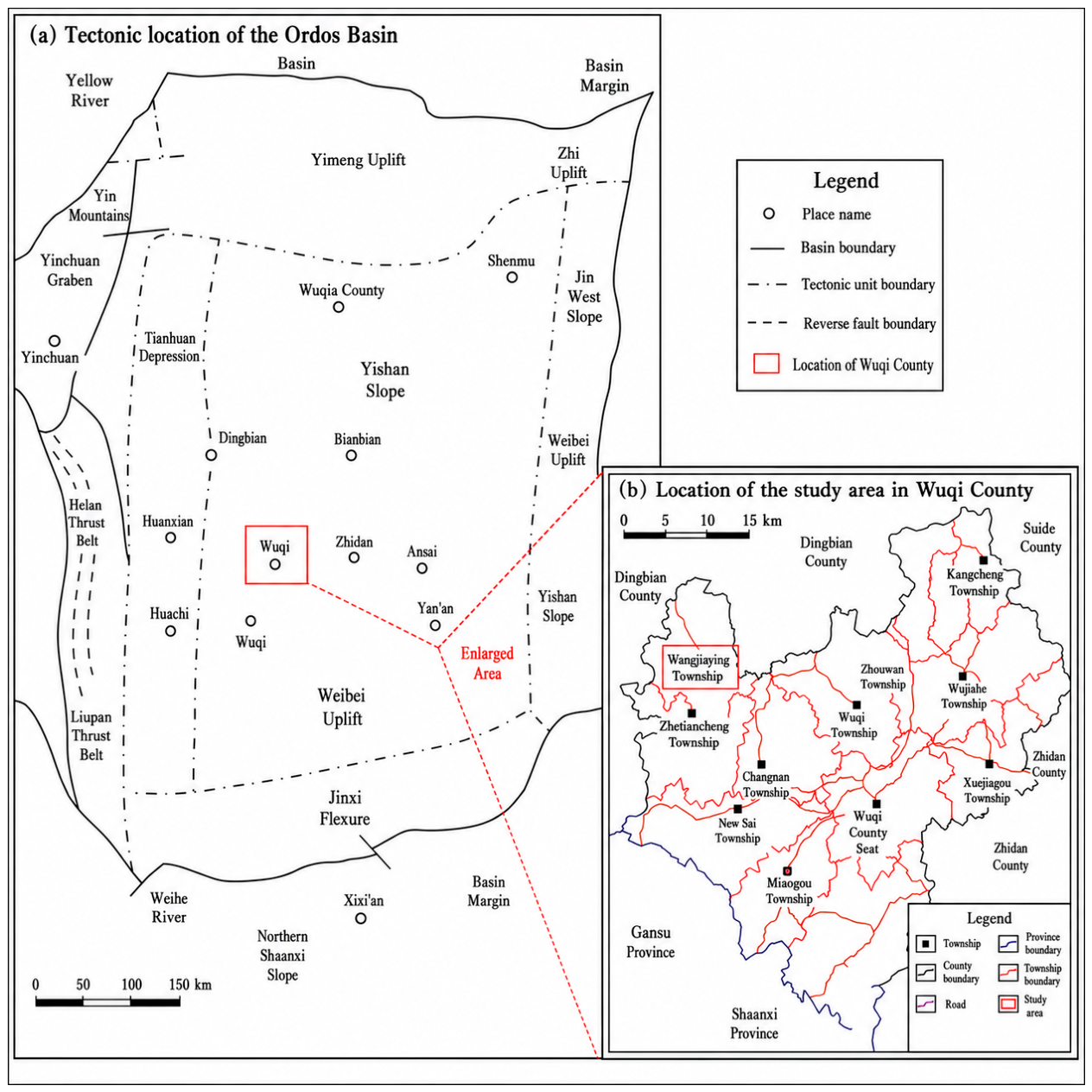
Figure 2.
Comprehensive sedimentary-microfacies interpretation of the Chang 9 Member in Well Wa 44.
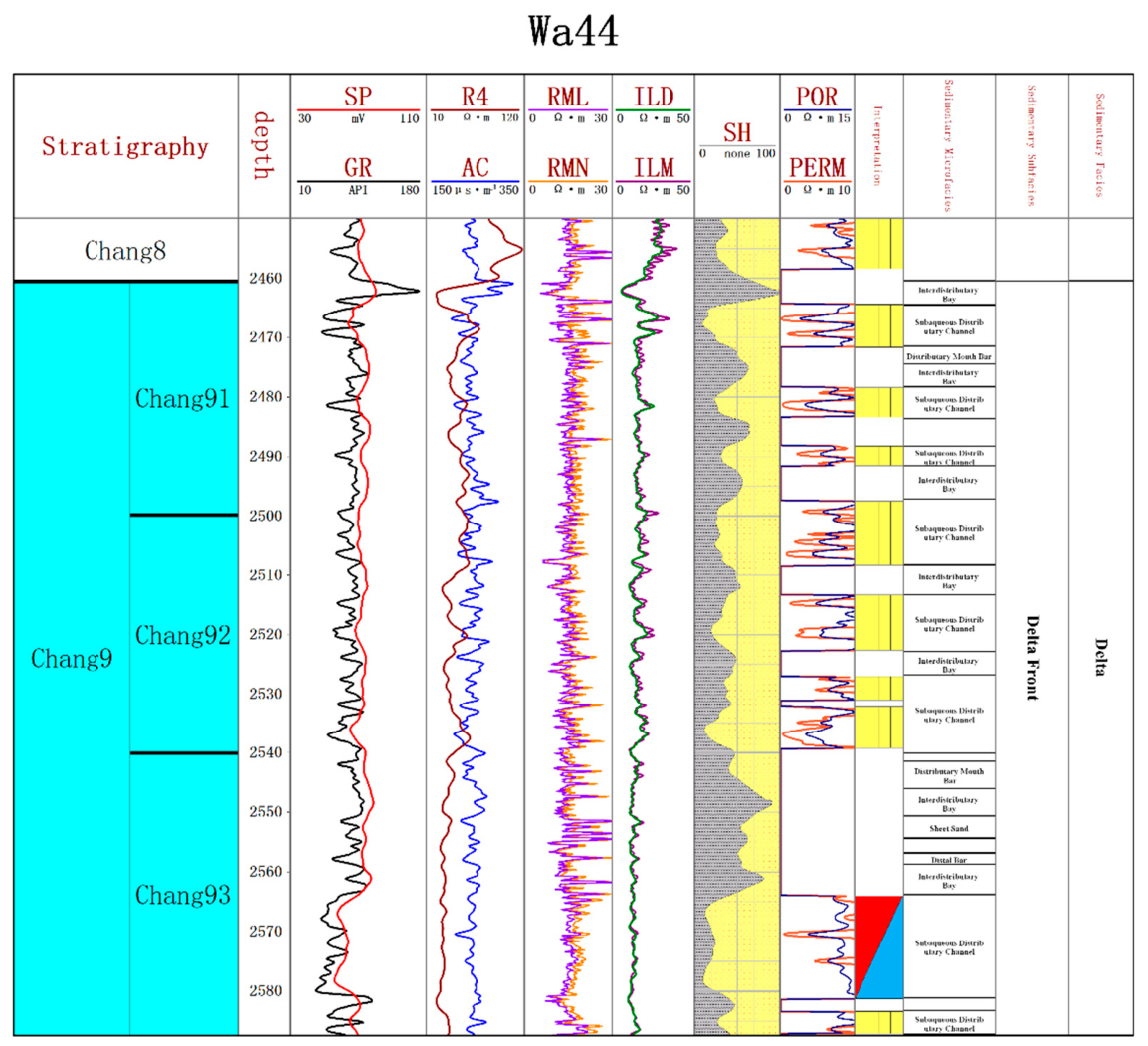
Figure 3.
Maps of sedimentary facies (left) and sand-body thickness (right) of the Chang 93 submember.
Figure 3.
Maps of sedimentary facies (left) and sand-body thickness (right) of the Chang 93 submember.
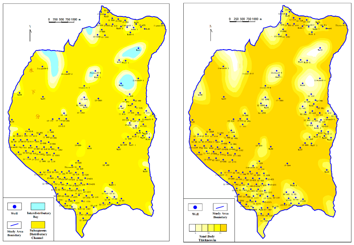
Figure 4.
Typical reservoir pore types in the Chang 9 Member.
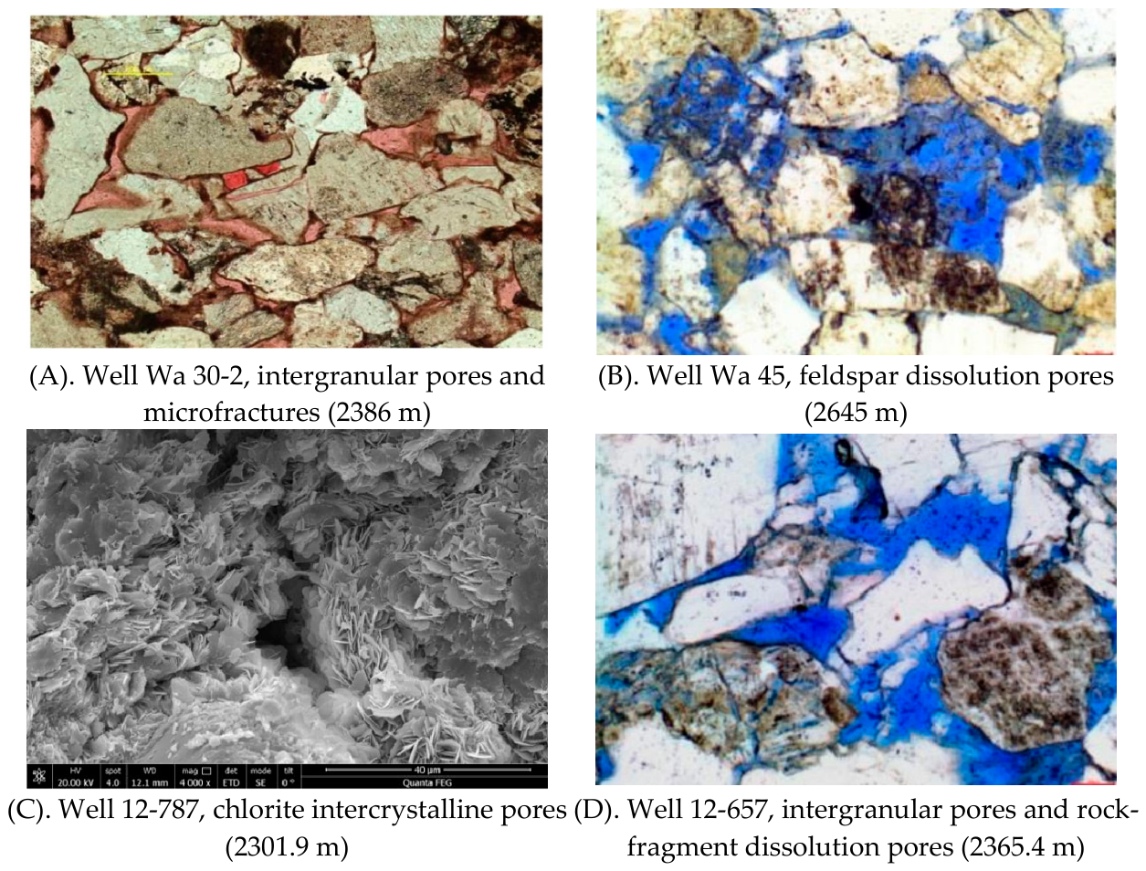
Figure 5.
Reservoir types of the Chang 9 Member in the Beiliang area, Wuqi.
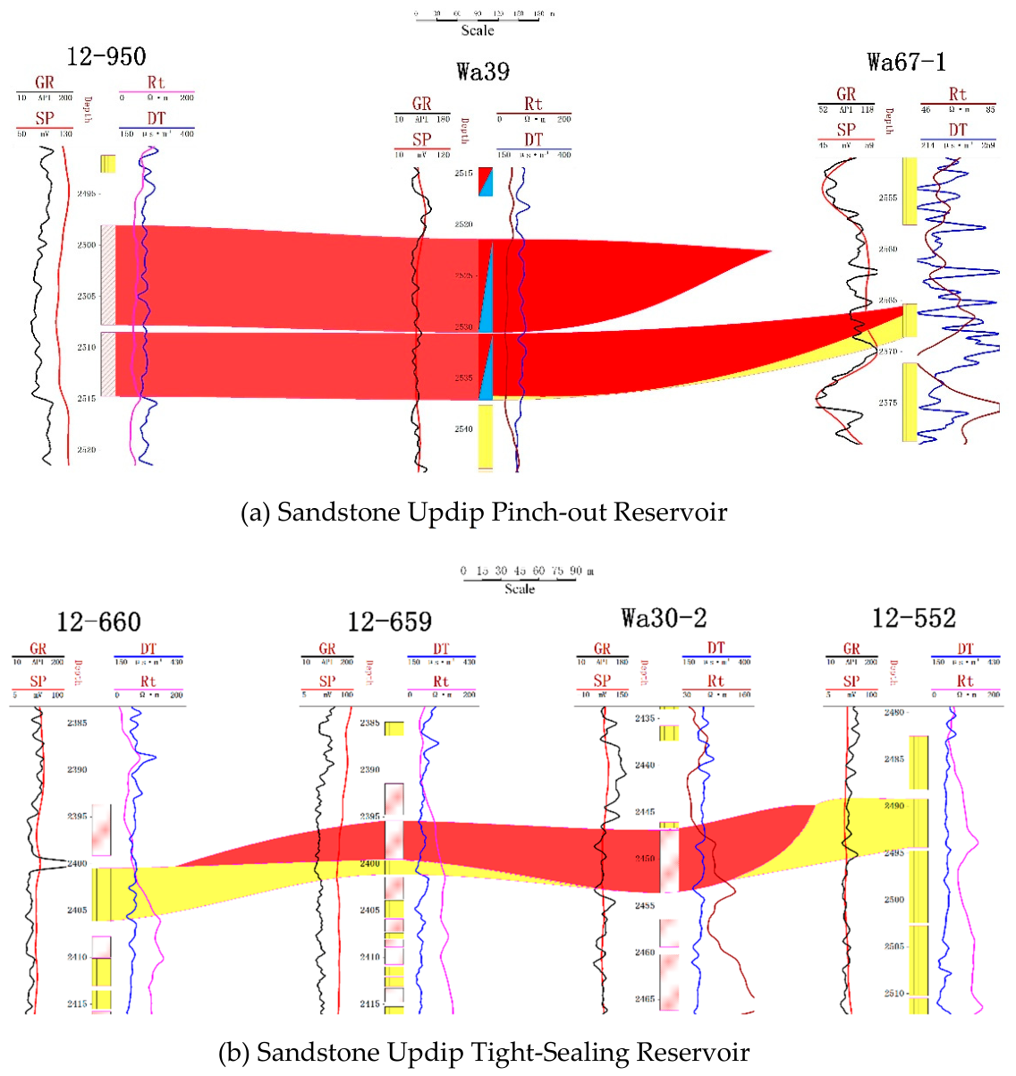
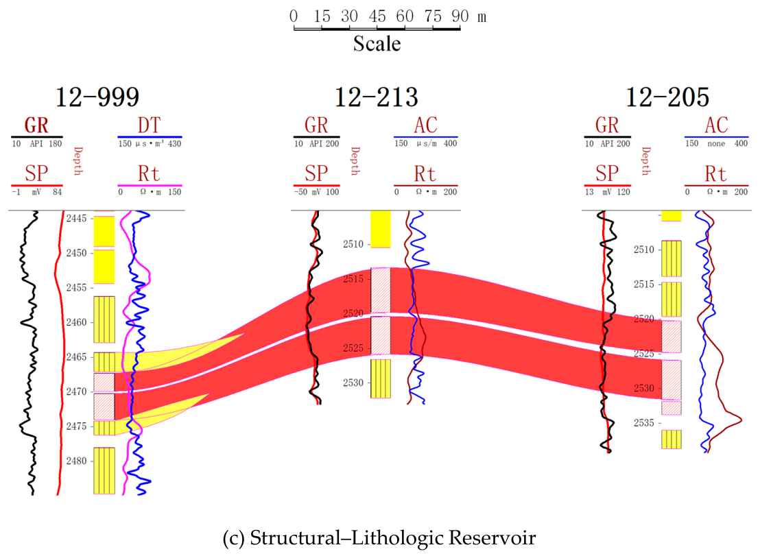
Figure 6.
Mud shale thickness maps of Chang 7 (a) and Chang 9 (b), Beiliang Oilfield.
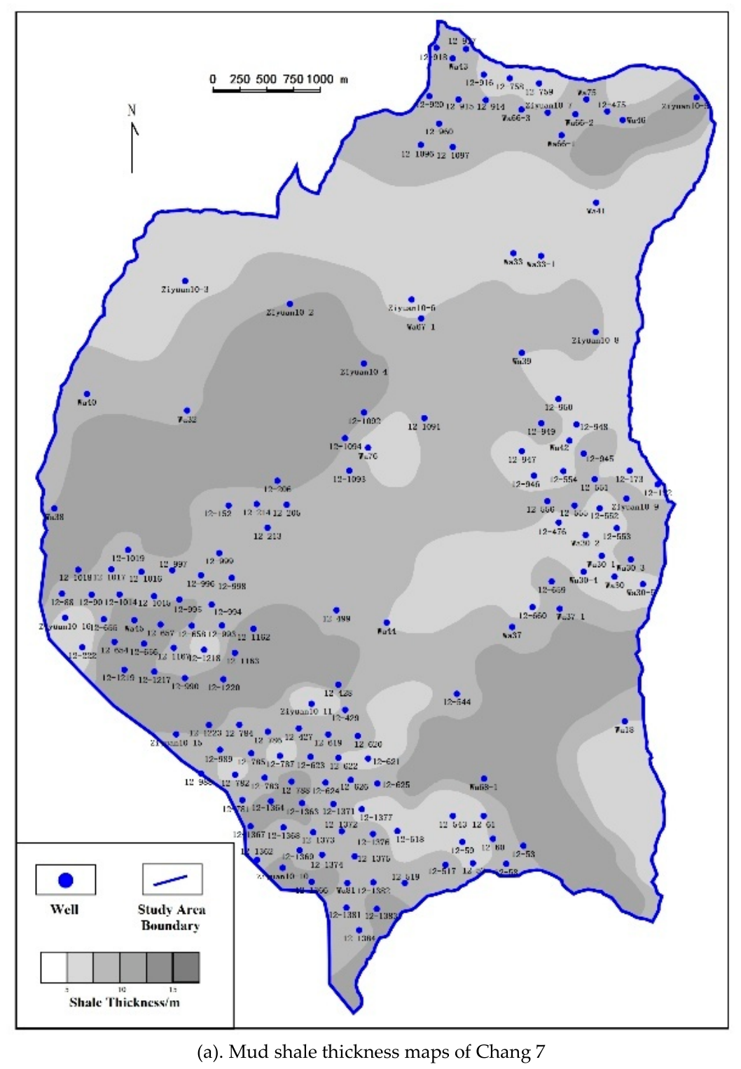
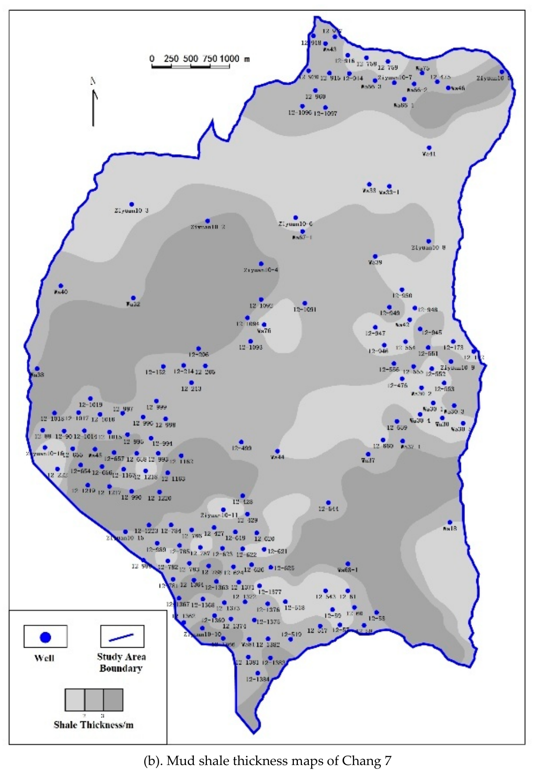
Figure 7.
Interwell lateral geological connectivity of sand bodies in the Chang 9 submembers.
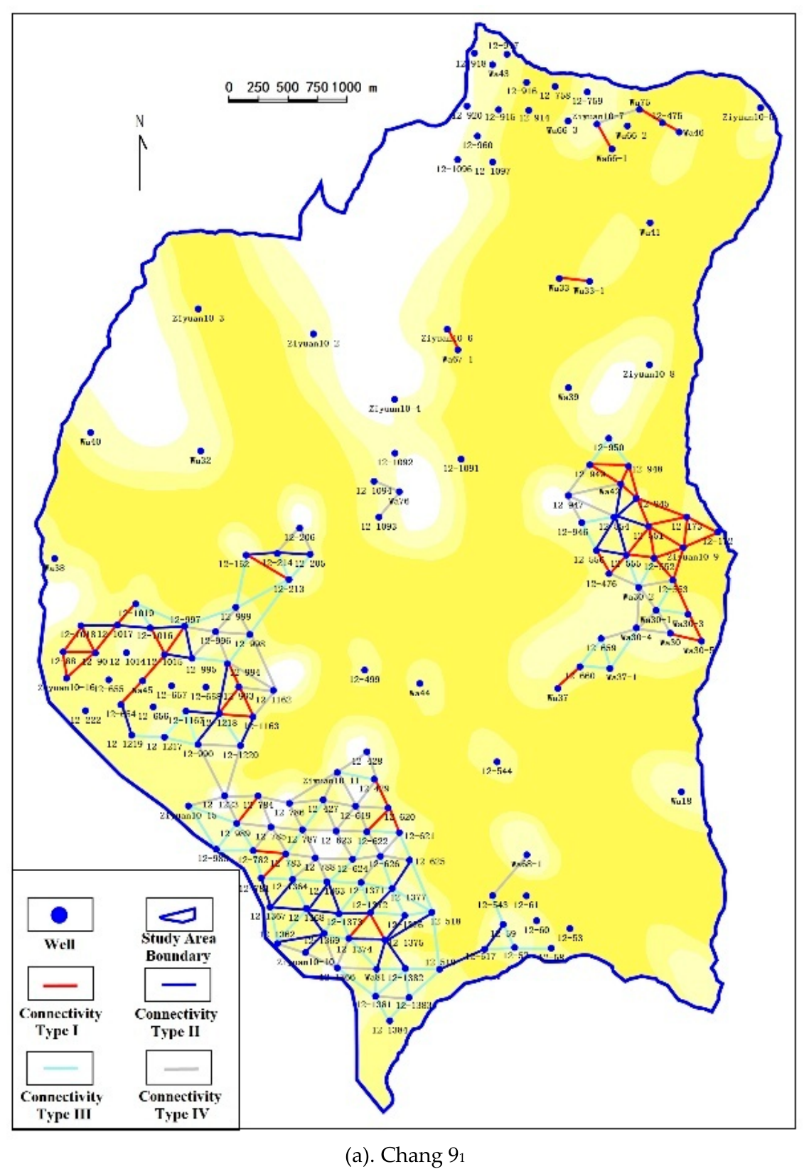
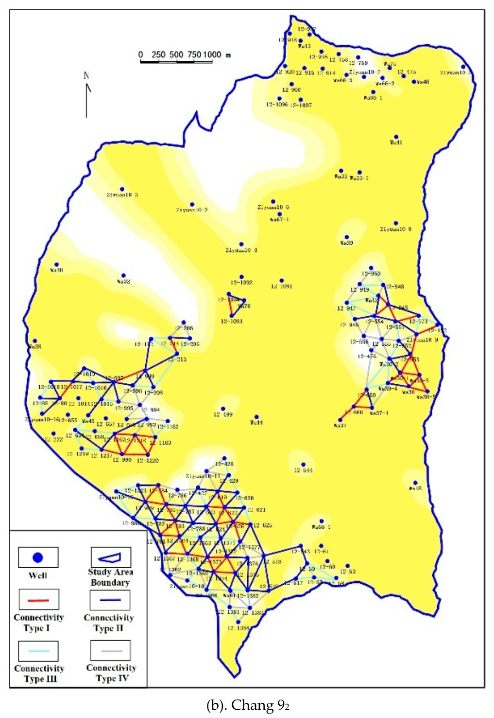
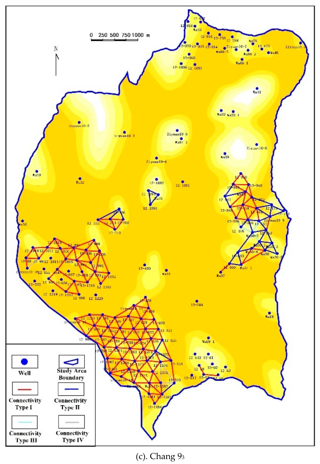
Figure 8.
Overlay map of the top structure, sand-body thickness, and oil-layer thickness of the Chang 93 submember in the Beiliang area, Wuqi.
Figure 8.
Overlay map of the top structure, sand-body thickness, and oil-layer thickness of the Chang 93 submember in the Beiliang area, Wuqi.
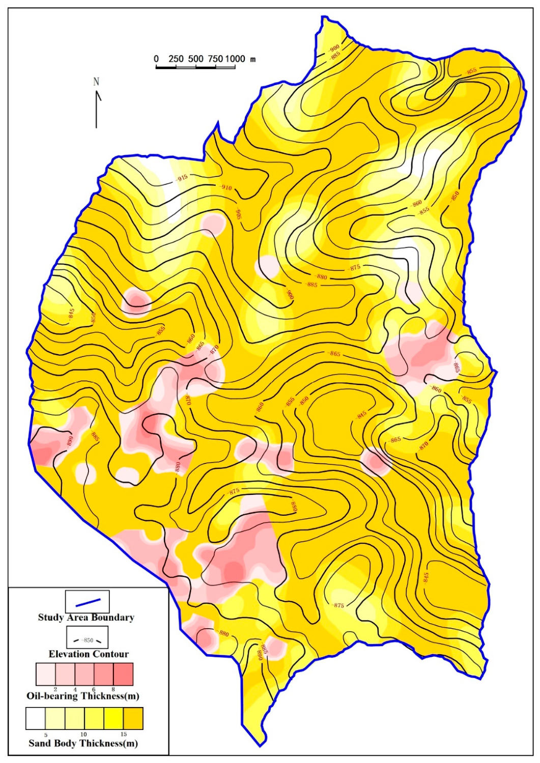
Figure 9.
Schematic hydrocarbon accumulation model of the Chang 9 reservoirs in the Beiliang Oilfield (modified from Reference [26]).
Figure 9.
Schematic hydrocarbon accumulation model of the Chang 9 reservoirs in the Beiliang Oilfield (modified from Reference [26]).
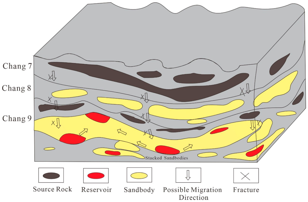

Table 1.
Stratigraphic division of the Yanchang Formation and subdivision of the Chang 9 Member in the Beiliang area, Wuqi.
Table 1.
Stratigraphic division of the Yanchang Formation and subdivision of the Chang 9 Member in the Beiliang area, Wuqi.
| Stratigraphy | Thickness (m) | ||||
| System | Series | Formation | Oil-bearing Formation | ||
| Stratigraphy | Upper Triassic | Yanchang Formation | Chang 1 | 70-90 | |
| Chang 2 | 25-172 | ||||
| Chang 3 | 78-150 | ||||
| Chang 4+5 | 50-146 | ||||
| Chang 6 | 71-201 | ||||
| Chang 7 | 50-121 | ||||
| Chang 8 | 57-135 | ||||
| Chang 9 | Chang91 | 37.9-44.6 | |||
| Chang92 | 36.6-44.9 | ||||
| Chang93 | 22.5-54.6 | ||||
| Chang10 | 100-300 | ||||
Table 2.
Criteria for identifying sedimentary microfacies in the Chang 9 Member.
| Microfacies Type | Lithologic Association | Logging Curve Characteristics | Sedimentary Structures | Reservoir Significance |
| Subaqueous Distributary Channel | Mainly fine-grained sandstone and silty fine sandstone | Box-shaped, bell-shaped, or serrated box-shaped | Scour surfaces and cross-bedding | Main reservoir sandstone |
| Interdistributary Bay | Mainly mudstone and silty mudstone | High gamma ray and low resistivity | Horizontal bedding | Lateral sealing |
| Distributary Mouth Bar | Siltstone and fine-grained sandstone | Funnel-shaped | Coarsening-upward sequence | Local reservoir |
| Sheet Sand | Thin-bedded siltstone | Low-amplitude, flat, or slightly serrated | Horizontal bedding | Moderate connectivity |
Table 3.
Statistics of log-derived petrophysical properties of the Chang 9 submembers.
| Sub-oil-bearing Formation | Number of Data Points | Porosity Range (%) | Average Porosity (%) | Average Porosity (%) | Average Permeability (10−3 μm2) | Comprehensive Evaluation |
| Chang 93 | 157 | 2.1~17.2 | 9.66 | 0.05~27.2 | 5.64 | Low-porosity and low-permeability reservoir |
| Chang 92 | 157 | 3.1~22.9 | 8.23 | 0.01~58.2 | 4.63 | Low-porosity and low-permeability reservoir |
| Chang 91 | 157 | 3.3~35.0 | 8.32 | 0.01~45.1 | 4.28 | Low-porosity and low-permeability reservoir |
Note: The number of data points refers to the number of points used for logging interpretation; permeability is expressed uniformly in 10−3 μm2.
Table 4.
Hydrochemical composition of formation water from the Chang 9 Member in the Beiliang area and adjacent blocks.
Table 4.
Hydrochemical composition of formation water from the Chang 9 Member in the Beiliang area and adjacent blocks.
| Well | Formation | Ion Concentration (mg/L) | Water Type | |||||||
| Cl− | SO42- | HCO3− | Ca2+ | Mg2+ | Na++K+ | Total Salinity | ||||
| Wu 47 | Chang 9 | 5582 | 201 | 831 | 251 | 25 | 3694 | 10585 | CaCl2 | |
| Wu 48 | Chang 9 | 4280 | 100 | 431 | 126 | 38 | 2771 | 7747 | CaCl2 | |
| Wu 69 | Chang 9 | 2999.1 | 480.3 | 81.64 | 551.1 | 364.65 | 251.28 | 6616.47 | CaCl2 | |
| Wa 19 | Chang 9 | 1499.5 | 1200 | 68.04 | 250.5 | 30.39 | 768.1 | 5190.71 | CaCl2 | |
Table 5.
Classification criteria for interwell lateral geological connectivity of sand bodies in the Chang 9 Member.
Table 5.
Classification criteria for interwell lateral geological connectivity of sand bodies in the Chang 9 Member.
| Connectivity Type | Criteria | Connectivity Evaluation | Significance for Hydrocarbon Accumulation |
| Type I | Same subaqueous distributary channel and genetically related sandbody | Good | Favorable for lateral hydrocarbon migration and continuous accumulation |
| Type II | ame microfacies, with lateral juxtaposition or extensive contact between different sandbodies | Fairly good | Can form locally effective migration pathways |
| Type III | Juxtaposition of different sandbodies or weak contact between different microfacies | Poor | Prone to compartmentalization and heterogeneous accumulation |
| Type IV | Separation of genetically different sandbodies | Disconnected | Forms distinct geological barriers |
Disclaimer/Publisher’s Note: The statements, opinions and data contained in all publications are solely those of the individual author(s) and contributor(s) and not of MDPI and/or the editor(s). MDPI and/or the editor(s) disclaim responsibility for any injury to people or property resulting from any ideas, methods, instructions or products referred to in the content. |
© 2026 by the authors. Licensee MDPI, Basel, Switzerland. This article is an open access article distributed under the terms and conditions of the Creative Commons Attribution (CC BY) license (http://creativecommons.org/licenses/by/4.0/).
Copyright: This open access article is published under a Creative Commons CC BY 4.0 license, which permit the free download, distribution, and reuse, provided that the author and preprint are cited in any reuse.