

Submitted:
15 August 2026
Posted:
17 August 2026
You are already at the latest version
Abstract
Rattans are important non-timber forest products that contribute significantly to the livelihoods of many rural communities across tropical Asia and Africa. However, increasing pressures from overexploitation and deforestation threaten the sustainability of these resources. Conventional field inventories are often labour-intensive and limited in spatial coverage, creating the need for more efficient monitoring approaches. This study evaluated the potential of drone imagery for detecting and inventorying rattan populations in the Hein agroforest located in the South-East Côte d’Ivoire, in tropical West Africa. Four plots containing native rattans were surveyed using both conventional ground inventories and drone-based image analysis. UAV images were processed into orthomosaics using Agisoft Metashape Pro and visually interpreted in QGIS through a grid-based approach. Density estimates obtained from both methods were compared using the Wilcoxon signed-rank test, while their relationship and agreement were assessed using Spearman correlation and Bland–Altman analysis, respectively. Five rattan species were identified at the species level within the study area. Results showed a significant difference between ground and drone-derived density estimates (V = 153, p < 0.001), with the drone method generally underestimating densities (mean bias = −25.22 ramets/ha). Nevertheless, a strong positive correlation was observed between methods (ρ = 0.762, p < 0.001). These findings highlight the potential of UAV imagery as a complementary tool for sustainable rattan monitoring and management.
Keywords:
UAV
; drone
; rattan palms
; inventory
; West Africa
1. Introduction
Palms, or the Arecaceae family, constitute one of the most important botanical families in terms of species diversity and utility for numerous communities worldwide. They provide substantial social and economic benefits through a wide range of uses [1,2]. Among these plants, a climbing group restricted to the Asian and African tropical rain forests and belonging to the subfamily Calamoideae, is particularly valued for its canes: the rattans. Rattans are spiny palms equipped with specialized vegetative organs, called flagella or cirri, that enable them to climb and attach themselves to surrounding vegetation. Their fruits are animal-dispersed (birds, small mammals), brightly coloured at maturity and characterized by the presence of overlapping scales [3,4]. Rattans are used in a wide range of economic activities, including the manufacture of woven handicrafts, baskets, furniture, fishing equipment (nets and traps), kitchen utensils, and other domestic items [2,5]. The apical meristem of certain species is also consumed as a vegetable after cooking, similarly to asparagus. As early as 2001, the global rattan sector involved more than 700 million users worldwide, employed approximately 1.2 million people, and generated over US$6.5 billion annually in Asia [6,7]. Today, rattan constitutes the basis of a thriving artisanal industry in many African countries [7,8,9]. In addition to the aforementioned uses, rattan palms are employed in the manufacture of baskets intended for kola nut exportation because of the flexibility and strength of their canes [10] Côte d’Ivoire has experienced a dramatic decline in forest cover, decreasing from approximately 16 million hectares at the beginning of the twentieth century to less than 3 million hectares today. This reduction in forest area is mainly driven by agricultural expansion, logging activities, and charcoal production [11]. Such a situation increasingly threatens the long-term survival of rattan populations, which are forest-dependent and primarily harvested from wild stands. There is therefore an urgent need to develop sustainable management strategies for the remaining rattan populations. In particular, the domestication of rattan species has become a priority to reduce pressure on wild resources and ensure a sustainable supply of planting material. This requires the rapid identification and mapping of existing populations, as well as the monitoring of their phenological status, so that timely decisions can be made regarding seed collection and conservation actions before forest areas are cleared or further degraded. Locating rattan populations in natural forests is particularly challenging using traditional ground surveys, which are often labour-intensive, time-consuming, and inefficient over large areas. In fact, due to their climbing growth habit and highly dependent of sunlight, rattan species only produce inflorescences and infructescences at the highest levels of the canopy, which severely hinders accurate observations and monitoring from the ground. Drones therefore represent a promising tool for rapidly detecting and mapping rattan populations, improving field efficiency while reducing survey costs and effort.
Drones are currently emerging as innovative and accessible tools for natural resource management in tropical countries [12,13,14,15]. They provide opportunities to collect data in increasingly constrained or inaccessible environments for humans [16]. Equipped with sensors and GPS positioning systems, these devices enable the remote acquisition of high-definition imagery over large land areas with spatial resolutions reaching the centimetre or even millimetre scale [14,17,18]. These numerous advantages have led to a growing number of applications in biodiversity conservation and management, both for fauna [19,20,21,22] and flora [15,23,24,25] in recent years. Drones are now considered essential tools for forest mapping and plant species inventories [17]. In 2020, studies by Ximena et al. enabled the identification and quantification of the palm species Mauritia flexuosa, Mauritiella armata, Euterpe precatoria, and Oenocarpus balickii in Peru using drone imagery combined with Random Forest (RF) and Support Vector Machine (SVM) classification algorithms. In the same region, Ferreira et al. (2020) developed a crown-based mapping approach for the palm species Attalea butyracea, Euterpe precatoria, and Iriartea deltoidea using convolutional neural network (CNN) algorithms. Similarly, studies conducted in temperate forests using drone imagery and CNN algorithms have enabled the identification of several plant species [26]. Other studies have successfully characterized and described the structure of savanna trees in Senegal using low-cost drones [27]. However, very few studies have explored the potential use of drones for the inventory and mapping of climbing plant species such as the economically important rattan palms. Furthermore, the techniques employed in the aforementioned studies generally require advanced knowledge in machine learning and deep learning. Such approaches are not always accessible to managers of protected forests and national parks, as they demand substantial technical expertise, financial resources, and additional time investment [28]. The main objective of this study is therefore to explore the potential of using drone-acquired imagery for the inventory of rattan populations subject to severe overharvesting and eventually heavily threatened of extinction at population level.
2. Materials and Methods
2.1. Study Site
This study was conducted within the Hein Agroforest (Figure 1), formerly the Hein Classified Forest, located 100 km North- East from Abidjan and 40 km from the town of Alépé in south-eastern Côte d’Ivoire (West Africa). The forest covers an area of 11,568 hectares. The Hein Agroforest is managed by the Société de Développement des Forêts (SODEFOR) and hosts a dense humid subequatorial forest dominated by species such as Musanga cecropioides R.Br. ex Tedlie, Heritiera utilis (Sprague) Sprague, and Diospyros gabunensis Gürke. The average canopy height ranges from 20 to 30 m. Annual rainfall averages approximately 1,350 mm, with a mean annual temperature of 25 °C.This site was selected based on a preliminary survey conducted among rattan cane harvesters in the municipality of Anyama. This municipality, located within the Autonomous District of Abidjan, constitutes the main hub of the rattan trade in Côte d’Ivoire. The craftsman and rattan harvesters interviewed identified the agroforest and classified forests of the Alépé region as one of the principal areas for rattan cane harvesting.
2.2. Study Species
Several rattan species were included in this study, namely Calamus deerratus G. Mann & H. Wendl., Eremospatha macrocarpa (G. Mann & H. Wendl.) Wendl., Eremospatha dransfieldii Sunderl., Laccosperma laeve (G. Mann & H. Wendl.) Wendl., and Laccosperma secundiflorum (P. Beauv.) Kuntze. These species have previously been reported from the study region [2,9]. Among the species studied, Eremospatha macrocarpa and Laccosperma secundiflorum are particularly valued by local harvesters and artisans because of their economically appreciated mechanical properties and wide range of uses.
2.3. Technical Materials
High-resolution aerial imagery was collected using a DJI Mavic 3 Pro drone (Figure 2). This compact quadcopter is equipped with a Hasselblad triple-camera system comprising a 20 MP 4/3 CMOS primary sensor and two telephoto lenses (70 mm and 166 mm). The drone has a maximum flight autonomy of 43 minutes, a maximum flight speed of 21 m·s⁻¹, and a weight of approximately 958 g. It incorporates a multi-band GNSS positioning system (GPS, Galileo, BeiDou) and omnidirectional obstacle-avoidance sensors, ensuring flight stability and precision. Agisoft Metashape Professional software (version 1.7.6) was used for photogrammetric processing to generate orthomosaics from the drone imagery. Quantum GIS (QGIS) software was also used to design counting grids and analyze orthomosaics. It was installed on a laptop equipped with an Intel® 13th Generation Core™ i7 processor (32 GB of RAM and 1 TB of storage), and an Intel® Iris® Xe Graphics card.
2.4. Methods
2.4.1. Field Based Rattan Inventory
As part of this study, four plots (A, B, C, and D) ranging from 2 to 4 hectares were established within the Hein Agroforest. A comprehensive inventory of rattan palms was conducted from April to November 2025 using purposive sampling combined with itinerant surveys. To ensure that no individual of the target species was overlooked, each sampling plot contained at least one individual belonging to one of the studied species [29]. The selection of this method was based on the ecology of the species, the rarity of certain taxa, and the difficult accessibility of the forest environment. The itinerant survey method consisted of traversing the study area in different directions while recording or collecting the target species encountered [30]. This inventory focused on ecological and demographic attributes, including species identification, development growth stage, number of clumps (genet), and the number of individuals per clump (ramet). Reference herbarium vouchers collected for species identification were deposited at the herbarium of the Centre Suisse de Recherches Scientifiques en Côte d’Ivoire (CSRS) and taxonomically identified using specialized literature (Genera Palmarum).
Figure 3.
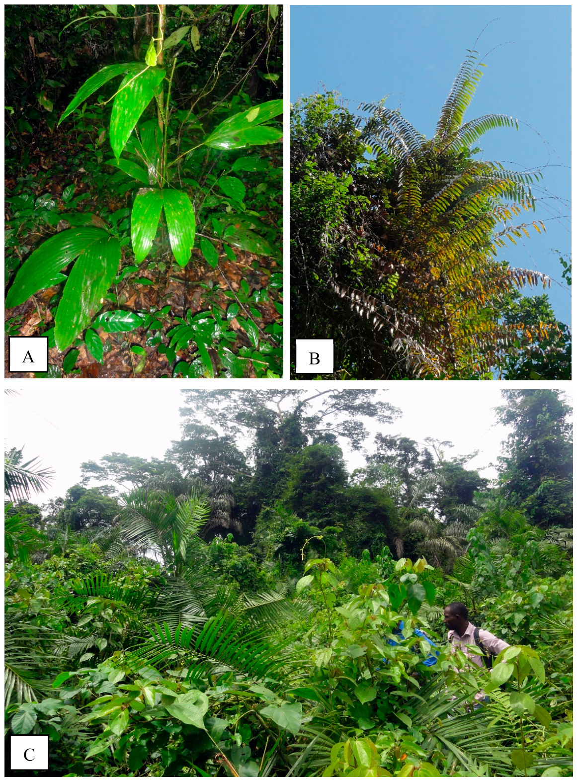
Taxonomic and ecologic diversity in two West African economically important rattan species. A-B. Eremospatha macrocarpa. Young, entire leaved individual growing in dense terra firme understory (A); fully mature pinnate leaved individual thriving at the highest level of the canopy (B). C. Calamus deerratus. Dense clumps of young individuals developing in fully sun exposed flooded areas. Hein agroforest, South-East Côte d’Ivoire.
Figure 3.
Taxonomic and ecologic diversity in two West African economically important rattan species. A-B. Eremospatha macrocarpa. Young, entire leaved individual growing in dense terra firme understory (A); fully mature pinnate leaved individual thriving at the highest level of the canopy (B). C. Calamus deerratus. Dense clumps of young individuals developing in fully sun exposed flooded areas. Hein agroforest, South-East Côte d’Ivoire.
2.4.2. Rattan Species Richness and Population Structure Assessment
Genera and species diversity were s assessed based on morphological and taxonomic characteristics. Population structure was evaluated by counting individuals of each species according to their developmental stage. The latter were defined following criteria commonly used for palms [31,32]. In this study, three developmental stages were considered:
- Juvenile (J): individuals with green stems up to 6 m in length, including those bearing fully developed leaves as well as young shoots with undeveloped leaves.
- Subadult (S): individuals with still-green harvestable stems exceeding 6 m in length.
- Adult (A): individuals bearing brown stems, with or without reproductive organs.
2.4.3. Rattan Species Population Abundance Assessment
Rattan abundance was estimated through an exhaustive count of all individuals recorded within the sampled plots. Certain palm species, including rattans, can produce multiple stems from a single rhizome, thereby forming clumps composed of genetically identical clones [3]. For practical purposes in our study, each clump was considered as a single individual.
2.4.4. Drone Mission Planning and Flight Operation
Drone flights were conducted over the four plots at altitudes ranging from 40 to 60 m with a camera angle of 90°. All flights were performed manually with image acquisition every 2 seconds at a speed of 3 m·s⁻¹ with a minimum of 85% front and 75% side overlap. Imagery was collected between 9:00 a.m. and 2:00 p.m. Five ground control points were used to correct geometric distortions in the imagery. Their coordinates were recorded using a Garmin 64 SX GPS.
2.4.5. Orthomosaics Production
The processing workflow comprised several stages, ranging from the importation of aerial images into the software to the generation of orthomosaics [33]. Following image importation, the images were aligned to match homologous points between overlapping photographs. Since the images were georeferenced, this step enabled the reconstruction of image geometry, which is essential for subsequent processing operations. The generation of the dense point cloud provided a more detailed three-dimensional representation of both vegetation and ground surface features. This stage directly influenced the quality and accuracy of the digital terrain models and orthomosaics produced. The parameters selected for each stage of the processing workflow are presented in Table 1.
2.4.6. Orthomosaics Analysis and Interpretation
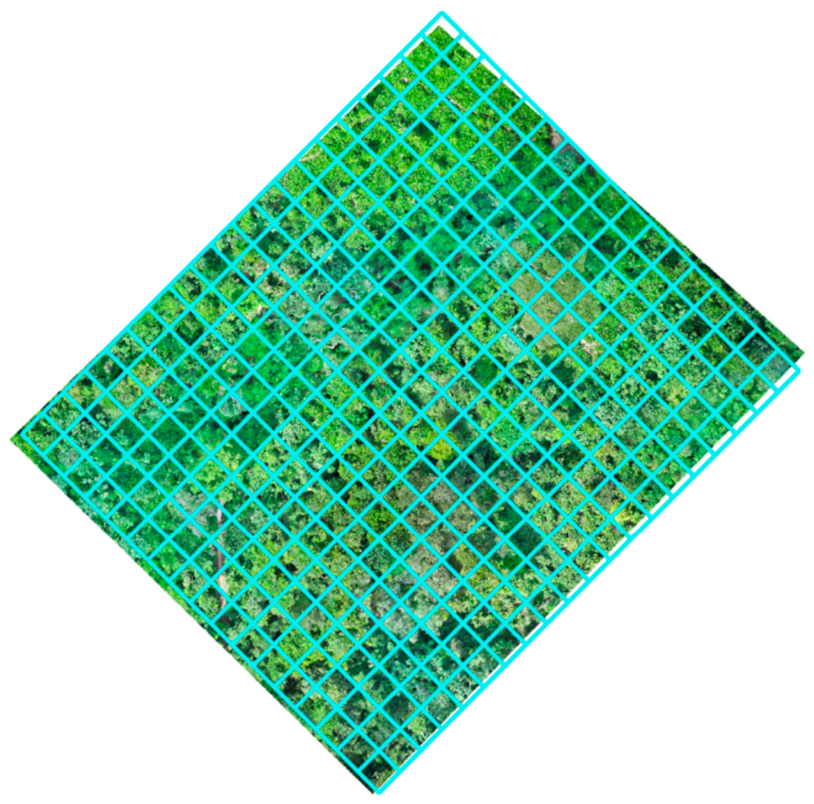
A visual analysis of the orthomosaics was carried out. The different orthomosaics produced were imported into the Geographic Information System software Quantum GIS (QGIS), and the images were examined at multiple scales to identify the various rattan palm species. Square counting grids of 100 m² (10 m × 10 m) were established to facilitate the detection and counting of rattans within the different plots. Observations were conducted systematically from left to right (horizontally) and from top to bottom (vertically) within each grid to ensure complete coverage of the orthomosaics. Rattan species identification was performed through visual interpretation based on canopy-visible morphological characteristics such as shape, organs (leaves, cirri, flowers arrangement), and spatial organization. A point-type shapefile was created to represent each observed rattan individual. The data were compiled using Microsoft Excel, and statistical analyses were conducted using R (version 4.4.1) and RStudio.
Figure 4.
An example of orthomosaics overlaid by a counting grid.
2.4.7. Statistical Analyses
Statistical analyses were performed using the R software environment [34]. The normality of density distributions was assessed using the Shapiro–Wilk test [35]. Homogeneity of variances between inventory methods was evaluated using Levene’s test. Given the non-normal distribution of the data and the heterogeneity of variances, non-parametric approaches were preferred. Differences between estimates obtained from ground-based inventories and drone-based surveys were tested using the paired Wilcoxon signed-rank test [36]. In addition, the relationship between both methods was evaluated using Spearman’s rank correlation coefficient [37] to assess the strength and direction of the monotonic association between ground-based and drone-derived density estimates. Finally, the agreement between the two inventory methods was assessed using a Bland–Altman analysis [38], which was used to estimate the mean difference and the limits of agreement between measurements.
3. Results
3.1. Ground Inventory Findings
3.1.1. Rattan Floristic Composition and Relative Abundance
A total of five rattan species were inventoried across the four study plots: Calamus deerratus, Eremospatha macrocarpa, Eremospatha dransfieldii, Laccosperma laeve, and Laccosperma secundiflorum. Plot A contained all five recorded species, whereas plots B, C, and D each harboured four species. In total, 389 rattan individuals were recorded across the study area, comprising 27 individuals of Calamus deerratus, 264 of Eremospatha macrocarpa, 17 of E. dransfieldii, 48 of Laccosperma laeve, and 33 of L. secundiflorum (Figure 5).
3.1.2. Rattan Demographic Structure
Distribution of rattan individuals across the different developmental stages revealed marked variations among the studied species (Figure 6). Analysis of the developmental-stage structure of the five species showed that Eremospatha macrocarpa, the most abundant species, exhibited the highest number of individuals at the juvenile stage, followed by the adult and subadult stages. In contrast, no juvenile individuals of Eremospatha dransfieldii, widely recognized as a rare and already threatened species across West Africa, were recorded, and only a limited number of subadult individuals were observed. For Calamus deerratus, the recorded individuals were predominantly adults, with only a few subadults detected, while no juvenile individuals were observed. Laccosperma secundiflorum displayed a larger number of juvenile and subadult individuals compared with adults. Conversely, Laccosperma laeve was characterized by a predominance of adult individuals, followed by the juvenile and subadult stages. Juvenile individuals of the different species were consistently observed at the base of buttressed large trees.
3.1.3. Density Based on Ground Survey
Inventories permitted to estimate the densities of both ramets and genets for the different rattan species. The overall densities recorded were 35 genets ha⁻¹ and 145 ramets ha⁻¹, corresponding to an average ratio of 4.14 ramets per genet. Genet densities exhibited marked interspecific variability, ranging from 2 genets ha⁻¹ for Eremospatha dransfieldii to 24 genets ha⁻¹ for E. macrocarpa. Similarly, ramet densities highly varied between 9 and 90 ramets ha⁻¹ depending on the species. E. macrocarpa was characterized by the highest genet density (24 ha⁻¹), which was also associated with the highest ramet density (90 ha⁻¹). In contrast, Calamus deerratus exhibited a lower genet density (2 ha⁻¹), with a ramet density of 19 ha⁻¹. The other species belonging to the genus Laccosperma, together with Eremospatha dransfieldii, showed low to intermediate densities. A detailed summary of these results is presented in Table 2.
3.2. Drone-Derived Findings
3.2.1. Performance of Drone Surveys for Rattan Species Detection and Identification
Analysis of the orthomosaics revealed that the rattan species Calamus deerratus, Eremospatha macrocarpa, E. dransfieldii, and Laccosperma secundiflorum could be detected and distinguished on the generated orthomosaics (Figure 7 and Figure 8), although some degree of confusion between species was observed depending on vegetation density. Only individuals emerging above the canopy or surrounding arboreal vegetation were clearly visible on the orthomosaics, whereas juvenile individuals could not be detected. In addition, no individuals of Laccosperma laeve were observable on the orthomosaics, regardless of their developmental stage.
3.2.2. Rattan Abundance and Density
Visual interpretation of the orthomosaics did not allow for the clear discrimination of genets (individuals composed of multiple stems) among the rattan species. Consequently, only ramets (stems) could be reliably identified and quantified. A total of 312 ramets were detected across all orthomosaics. Among these, 93 ramets of Calamus deerratus were recorded, corresponding to a density of 8 ramets ha⁻¹. Eremospatha macrocarpa accounted for 171 ramets, with a density of 16 ramets ha⁻¹, while E. dransfieldii represented 35 ramets and a density of 3 ramets ha⁻¹. Finally, Laccosperma secundiflorum was the least abundant species, with 13 ramets corresponding to a density of 1 ramet ha⁻¹.
3.2.3. Relation Between Ground-Based and Drone-Based Inventory
Rattan density data were not normally distributed (Shapiro–Wilk test: W = 0.619, p < 0.001), indicating marked heterogeneity across observations. Variance also differed significantly between inventory methods (Levene’s test: F = 6.51, p = 0.015), supporting the use of non-parametric approaches for subsequent analyses. The paired Wilcoxon signed-rank test indicated a statistically significant difference between ground-based and drone-derived density estimates (V = 153, p < 0.001). Overall, the two methods did not produce equivalent absolute values. However, a strong positive association was observed between estimates from both approaches (Spearman’s ρ = 0.762, p < 0.001), indicating consistent ranking of plots across methods. Plots with high ground -measured densities generally also showed high values in the orthomosaics-based estimates (Figure 9). Bland–Altman analysis showed an average difference of −25.22 ramets/ha between the drone-based and ground inventories, indicating that the drone method tended to slightly underestimate rattan density overall. The 95% limits of agreement ranged from −92.96 to 42.52 ramets/ha, reflecting a widespread in the differences between the two approaches across sampling plots. While most of the values remained within these limits, the variability suggests that the level of agreement was not consistent (Figure 10).
4. Discussion
This study enabled an inventory of rattan species present in the Hein agroforest combining a conventional ground -based inventory method with an innovative approach using a drone equipped with a standard RGB sensor. In total, five rattan species were recorded in this forest, namely Calamus deerratus, Eremospatha macrocarpa, E. dransfieldii, Laccosperma laeve and L. secundiflorum. Among these, E. dransfieldii, classified as an endangered species on the IUCN Red List, was identified. The most abundant species was E. macrocarpa, and the individuals observed were predominantly at the juvenile stage. Estimates of rattan density may be influenced by the definition of the sampling unit, which varies according to the species studied and the objectives of the study [39,40,41]. Rattans are clonal species, a single genetic individual can produce several stems from a common rhizome [3]. This clump-like organisation distinguishes genets, corresponding to genetic individuals, from ramets, corresponding to stems. For the purposes of this study, ramets were considered as units of observation during drone-based inventories. The relatively low densities observed for rattans palms species could be explained by the gradual degradation of the forest, particularly linked to the expansion of cocoa plantations and the intensive harvesting of rattan canes. By way of comparison, studies carried out in the N’Zodji classified forest, located in an ecologically similar area to Hein agroforest, reported significantly higher densities for E. macrocarpa and L. secundiflorum, reaching 71 and 83 genets/ha [9] and 154 and 106 ramets/ha respectively. . These discrepancies suggest a significant and rapid change in the density of local populations, most probably linked to anthropogenic pressures. The differences observed between species may also be explained by their ecological traits and their light and habitat requirements. For example, E. macrocarpa is a heliophilous species, favouring clearings and forest edges, whilst L. secundiflorum is more shade-tolerant and grows beneath the canopy of mature forests [42].
Drones appear to be promising tools for the assessment and management of natural resources, particularly in complex tropical ecosystems [12,15,43,44]. In this study, visual analysis of orthomosaics derived from drone imagery, coupled with field data, enabled us to explore their potential for rattan inventory. Several studies have already demonstrated the value of comparing estimates derived from drone imagery and ground-based inventories for vegetation assessment, particularly in the case of climbing plants [23,39,40]. These studies generally report a positive correlation between the two approaches.
In this study, the strong correlation observed between the methods confirms the suitability of the drone-based approach for rattan inventory in forest environments. However, the discrepancies observed in the estimation of ramet densities can be attributed to the conventional limitations of remote sensing, notably spatial resolution, the structural complexity of tropical forests, canopy shading, as well as the architectural variability of individual plants and the low detectability of young, small, or partially obscured stems [39,45,46]. Bland-Altman analysis indicates a negative mean bias, suggesting a general underestimation of ramet densities by the drone-based method compared to ground surveys. The relatively wide limits of agreement reflect significant variability between the two methods across plots, indicating that the drone-based approach cannot yet fully replace ground inventories for accurate density estimates. Nevertheless, the overall consistency of trends between the two approaches highlights the value of drones for rapid ecological assessments and large-scale monitoring.
Finally, the results obtained provide a promising methodological basis for forest managers and researchers involved in the assessment and conservation of non-timber forest products.
5. Conclusions
This study enabled the inventory of five rattan species within the Hein agroforest and demonstrated the potential of drone-based approaches for the assessment of rattan palms in tropical agroforestry ecosystems. However, the results revealed that the drone-based method tended to underestimate rattan density compared with conventional ground-based inventories. This discrepancy highlights the current methodological limitations of the approach while also emphasizing its potential for further optimization and large-scale application across extensive forested areas. Although already showing promising results, the drone-based method still needs to be improved to accurately assess species level identification and densities in rattan populations. Coupled with ground-based methods, these strategies may be extremely helpful to provide critical data for the proposal of strategies aiming sustainable rattan harvesting at larger spatial scales. Future research should investigate the integration of artificial intelligence-based classification approaches, as well as the use of multispectral and LiDAR sensors, to improve rattan detection, particularly at early developmental stages, and to enhance the accuracy of density estimates.
Author Contributions
Conceptualization, D.A.C., F.S. and D.N.O.; methodology, D.A.C. and D.N.O.; software, D.A.C. and L. D. D.; validation, D.A.C., D.N.O, F. S., A.B., Y.S., and H.G.D.; formal analysis, D.A.C and H.G.D.; investigation, D.A.C., L.D.D. and Y.S.; resources, D.A.C., D.N.O, Y.S., and A.B. data curation, D.A.C., D.N.O, F.S., Y.S., A.B. and H.G.D.; writing—original draft preparation, D.A.C.; writing—review and editing, D.A.C., D.N.O, F.S., Y.S., A.B. and H.G.D.; visualization, D.A.C., D.N.O, F.S., Y.S., L.D.D., A.B. and H.G.D.; supervision, F.S., D.N.O, A.B., and H.G.D.; project administration, D.A.C., D.N.O.; funding acquisition, D.N.O, F.S., A.B. and D.A.C. All authors have read and agreed to the published version of the manuscript.
Funding
This research was conducted in the frame of MULTIPALMS project (www.multipalms.com) funded by Audemars Piguet Foundation.
Data Availability Statement
The data that support the findings of this study are available from the corresponding author upon reasonable request.
Acknowledgments
We acknowledge the financial support provided by the Audemars Piguet Foundation through the MULTIPALMS project for the implementation of this study. We also express our sincere gratitude to the Société de Développement des Forêts (SODEFOR) for facilitating access to the agroforests. Finally, we would like to thank all reviewers whose valuable comments and suggestions contributed significantly to the improvement of this work.
Conflicts of Interest
The authors declare no conflicts of interest.
References
- Dransfield, J.; Uhl, N.W.; Asmussen, C.B.; Baker, W.J.; Harley, M.M.; Lewis, C.E. Genera Palmarum-the Evolution and Classification of the Palms; Royal Botanic Gardens: Kew, 2008. [Google Scholar]
- Stauffer, F.W.; Ouattara, D.N.; Michon, L.; Da Giau, S.; Ekpe, P.; Adeoti, K.; Ewedje, E.; Koudouvo, K.; Roguet, D.; Chatelain, C.; et al. The palm flora of West Africa: Côte d’Ivoire, Ghana, Togo and Bénin. Arch. Des. Sci. 2021, 72, 1–77. [Google Scholar]
- Sunderland, T.C.H. A Taxonomic Revision of the Rattans of Africa (Arecaceae: Calamoideae). Phytotaxa 2012, 51, 1–76. [Google Scholar] [CrossRef]
- Baker, W.J.; Dransfield, J. Beyond Genera Palmarum: Progress and Prospects in Palm Systematics. Bot. J. Linn. Soc. 2016, 182, 207–233. [Google Scholar] [CrossRef]
- Ouattara, D.N.; Ekpe, P.; Bakayoko, A.; Stauffer, F.W. Ethnobotany and Conservation of Palms from Ghana. Palms 2015, 59. [Google Scholar]
- Sastry, C.B. Rattan in the Twenty-First Century - An Overview. Unasylva 2001, 52, 3–10. [Google Scholar]
- Bi, Zoro; Kouakou, K.L. Étude de la filière rotin dans le district d’Abidjan (Sud Côte d’Ivoire). Biotechnol. Agron. Soc. Env. 2004, 199–209. [Google Scholar]
- Sunderland, T.C.H. The Taxonomy, Ecology and Utilisation of African Rattans (Palmae: Calamoideae) London, UK; University College, 2001. [Google Scholar]
- Kouassi, K.I.; Barot, S.; Bi, I.A.Z. Population Structure and Reproductive Strategy of Two Multiple-Stemmed Rattans of Côte d’Ivoire. Palms 2009, 53. [Google Scholar]
- Coulibaly, D.A. Diversité des Palmiers rotins (Arecaceae) du Parc national du Banco et de la Réserve naturelle volontaire Forêt des Marais Tanoé- Ehy et multiplication végétative de quelques espèces. In Mémoire de Master; Université Nangui Abrogoua: Abidjan (Côte d’Ivoire), 2023. [Google Scholar]
- Cuny, P.; Plancheron, F.; Bio, A.; Kouakou, E.; Morneau, F. La forêt et la faune de Côte d’Ivoire dans une situation alarmante – Synthèse des résultats de l’Inventaire forestier et faunique national. Bois For. Trop. 2023, 355, 47–72. [Google Scholar] [CrossRef]
- Tang, L.; Shao, G. Drone Remote Sensing for Forestry Research and Practices. J. For. Res. 2015, 26, 791–797. [Google Scholar] [CrossRef]
- Banu, T.P.; Gheorghe, F. B.; Constantin, B. The Use of Drones in Forestry. J. Environ. Sci. B. 2016, 5. [Google Scholar] [CrossRef]
- Goodbody, T.R.H.; Coops, N.C.; Marshall, P.L.; Tompalski, P.; Crawford, P. Unmanned Aerial Systems for Precision Forest Inventory Purposes: A Review and Case Study. For. Chron. 2017, 93, 71–81. [Google Scholar] [CrossRef]
- Fassnacht, F.E.; White, J.C.; Wulder, M.A.; Næsset, E. Remote Sensing in Forestry: Current Challenges, Considerations and Directions. Forestry 2024, 97, 11–37. [Google Scholar] [CrossRef]
- Lyu, X.; Li, X.; Dang, D.; Dou, H.; Wang, K.; Lou, A. Unmanned Aerial Vehicle (UAV) Remote Sensing in Grassland Ecosystem Monitoring: A Systematic Review. Remote Sens. 2022, 14, 1096. [Google Scholar] [CrossRef]
- Casapia, X.T.; Falen, L.; Bartholomeus, H.; Cárdenas, R.; Flores, G.; Herold, M.; Honorio Coronado, E.N.; Baker, T.R. Identifying and Quantifying the Abundance of Economically Important Palms in Tropical Moist Forest Using UAV Imagery. Remote Sens. 2020, 12. [Google Scholar] [CrossRef]
- Simpson, G.; Nichol, C.J.; Wade, T.; Helfter, C.; Hamilton, A.; Gibson-Poole, S. Species-Level Classification of Peatland Vegetation Using Ultra-High-Resolution UAV Imagery. Drones 2024, 8, 97. [Google Scholar] [CrossRef]
- Ezat, M.A.; Fritsch, C.J.; Downs, C.T. Use of an Unmanned Aerial Vehicle (Drone) to Survey Nile Crocodile Populations: A Case Study at Lake Nyamithi, Ndumo Game Reserve, South Africa. Biol. Conserv. 2018, 223, 76–81. [Google Scholar] [CrossRef]
- Zhang, H.; Wang, C.; Turvey, S.T.; Sun, Z.; Tan, Z.; Yang, Q.; Long, W.; Wu, X.; Yang, D. Thermal Infrared Imaging from Drones Can Detect Individuals and Nocturnal Behavior of the World’s Rarest Primate. Glob. Ecol. Conserv. 2020, 23, e01101. [Google Scholar] [CrossRef]
- Aubert, C.; Moguédec, G.L.; Assio, C.; Blatrix, R.; Ahizi, M.N.; Hedegbetan, G.C.; Kpera, N.G.; Lapeyre, V.; Martin, D.; Labbé, P.; et al. Evaluation of the Use of Drones to Monitor a Diverse Crocodylian Assemblage in West Africa. Wildl. Res. 2021, 49, 11–23. [Google Scholar] [CrossRef]
- Schad, L.; Fischer, J. Opportunities and Risks in the Use of Drones for Studying Animal Behaviour. Methods Ecol. Evol. 2023, 14, 1864–1872. [Google Scholar] [CrossRef]
- Waite, C.E.; van der Heijden, G.M.F.; Field, R.; Boyd, D.S. A View from above: Unmanned Aerial Vehicles (UAVs) Provide a New Tool for Assessing Liana Infestation in Tropical Forest Canopies. J. Appl. Ecol. 2019, 56, 902–912. [Google Scholar] [CrossRef]
- Mosig, C.; Vajna-Jehle, J.; Mahecha, M.D.; Cheng, Y.; Hartmann, H.; Montero, D.; Junttila, S.; Horion, S.; Schwenke, M.B.; Adu-Bredu, S.; et al. Deadtrees.Earth - An Open-Access and Interactive Database for Centimeter-Scale Aerial Imagery to Uncover Global Tree Mortality Dynamics. BioRixv 2024, 10.18.619094. [Google Scholar]
- Nyberg, B.; Bairos, C.; Brimhall, M.; Deans, S.M.; Hanser, S.; Heintzman, S.; Hillmann Kitalong, A.; Menezes de Sequeira, M.; Nobert, N.; Rønsted, N.; et al. The Conservation Impact of Botanical Drones: Documenting and Collecting Rare Plants from Vertical Cliffs and Other Hard-to-Reach Areas. Ecol. Solut. Evid. 2024, 5, e12318. [Google Scholar] [CrossRef]
- Schiefer, F.; Kattenborn, T.; Frick, A.; Frey, J.; Schall, P.; Koch, B.; Schmidtlein, S. Mapping Forest Tree Species in High Resolution UAV-Based RGB-Imagery by Means of Convolutional Neural Networks. ISPRS J. Photogramm. Remote Sens. 2020, 170, 205–215. [Google Scholar] [CrossRef]
- Bossoukpe, M.; Faye, E.; Ndiaye, O.; Diatta, S.; Diatta, O.; Diouf, A.A.; Dendoncker, M.; Assouma, M.H.; Taugourdeau, S. Low-Cost Drones Help Measure Tree Characteristics in the Sahelian Savanna. J. Arid Environ. 2021, 187, 104449. [Google Scholar] [CrossRef]
- Tangen, B.A.; Esser, R.L.; Walker, B.A. Visual Interpretation of High-Resolution Aerial Imagery: A Tool for Land Managers. J. Fish. Wildl. Manag. 2024, 15, 312–326. [Google Scholar] [CrossRef]
- Rakoto, R.H. Evaluation Bio-Écologique de Quelques Espèces de Palmiers Endémiques et Menacées de Madagascar : Cas de Dypsis Pilulifera (Beccari) Beentje & Dransfield, de Dypsis Utilis (Jumelle) Beentje & Dransfield Dans La Réserve Spéciale d’Andasibe, de Dypsis Arenarum (Jumelle) Beentje & Dransfield et de. Dypsis Tsaravoasira Beentje Dans La Station Forestière de Tampolo 2005. [Google Scholar]
- Malan, D.F.; Assi, L.; Tra Bi, F.H. Neuba D Diversité floristique du Parc National des Iles Ehotilé (littoral est de la Côte d’Ivoire). Bois For. Trop. 2007, 49–58. [Google Scholar] [CrossRef]
- Escalante, S.; Montaña, C.; Orellana, R. Demography and Potential Extractive Use of the Liana Palm, Desmoncus Orthacanthos Martius (Arecaceae), in Southern Quintana Roo, Mexico. For. Ecol. Manag. 2004, 187, 3–18. [Google Scholar] [CrossRef]
- Kouassi, K.I.; Barot, S.; Gignoux, J.; Zoro Bi, I.A. Demography and Life History of Two Rattan Species, Eremospatha Macrocarpa and Laccosperma Secundiflorum, in Côte d’Ivoire. J. Trop. Ecol. 2008, 24, 493–503. [Google Scholar] [CrossRef]
- Metashape, Agisoft. Agisoft Metashape User Manual Professional Edition, Version 2.2. 2025. [Google Scholar]
- R Core Team R: A Language and Environment for Statistical Computing; R Foundation for Statistical Computing: Vienna, Austria, 2024.
- Royston, P. Remark AS R94: A Remark on Algorithm AS 181: The W-Test for Normality. J. R. Stat. Soc. C Appli. Stat. 1995, 44, 547–551. [Google Scholar] [CrossRef]
- Wilcoxon, F. Individual Comparisons by Ranking Methods. Biom. Bull. 1945, 1, 80–83. [Google Scholar] [CrossRef]
- Spearman, C. The Proof and Measurement of Association between Two Things. Am. J. Psychol. 1904, 15, 72–101. [Google Scholar] [CrossRef]
- Bland, J.M.; Altman, Douglas G. STATISTICAL METHODS FOR ASSESSING AGREEMENT BETWEEN TWO METHODS OF CLINICAL MEASUREMENT. Lancet 1986, 327, 307–310. [Google Scholar] [CrossRef]
- Kaçamak, B.; Barbier, N.; Aubry-Kientz, M.; Forni, E.; Gourlet-Fleury, S.; Guibal, D.; Loumeto, J.-J.; Pollet, S.; Rossi, V.; Rowe, N.; et al. Linking Drone and Ground-Based Liana Measurements in a Congolese Forest. Front. For. Glob. Change 2022, 5. [Google Scholar] [CrossRef]
- Kovacs, V.; Kruger, C.; van Rensburg, G.J.; Kruger, F.; Schmidt, L. Comparing Drone and Field Based Methods for Assessing Cryptostegia Grandiflora Density along the Mogalakwena River in South Africa. Discov. Ecol. 2025, 1, 12. [Google Scholar] [CrossRef]
- Schnitzer, S.A.; DeWalt, S.J.; Chave, J. Censusing and Measuring Lianas: A Quantitative Comparison of the Common Methods. Biotropica 2006. [Google Scholar] [CrossRef]
- Sunderland, T. Field Guide to the Rattans of Africa. Edin. J. Bot. 2007, 65, 351–352. [Google Scholar] [CrossRef]
- Navarro, A.; Young, M.; Allan, B.; Carnell, P.; Macreadie, P.; Ierodiaconou, D. The Application of Unmanned Aerial Vehicles (UAVs) to Estimate Above-Ground Biomass of Mangrove Ecosystems. Remote Sens. Environ. 2020, 242, 111747. [Google Scholar] [CrossRef]
- Tagle Casapia, X.; Cardenas-Vigo, R.; Marcos, D.; Fernández Gamarra, E.; Bartholomeus, H.; Honorio Coronado, E.N.; Di Liberto Porles, S.; Falen, L.; Palacios, S.; Tsenbazar, N.-E.; et al. Effective Integration of Drone Technology for Mapping and Managing Palm Species in the Peruvian Amazon. Nat. Commun. 2025, 16, 3764. [Google Scholar] [CrossRef]
- Visser, M.D.; Detto, M.; Meunier, F.; Wu, J.; Foster, J.R.; Marvin, D.C.; van Bodegom, P.M.; Bongalov, B.; Nunes, M.H.; Coomes, D.; et al. Why Can We Detect Lianas from Space? BioRixv2023 2021, 462145. [Google Scholar]
- Caron-Guay, A.; Germain, M.; Laliberté, E. Early Detection of Common Reed (Phragmites Australis) Using Unoccupied Aerial Vehicles and Deep Learning. Can. J. Remote Sens. 2026, 52, 2647490. [Google Scholar] [CrossRef]
Figure 1.
Geographic location of Hein agroforest in Côte d’Ivoire.
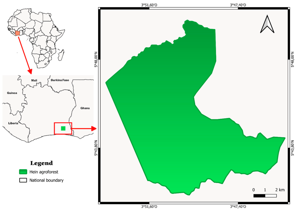
Figure 2.
Mavic 3 pro drone and its radio controller.
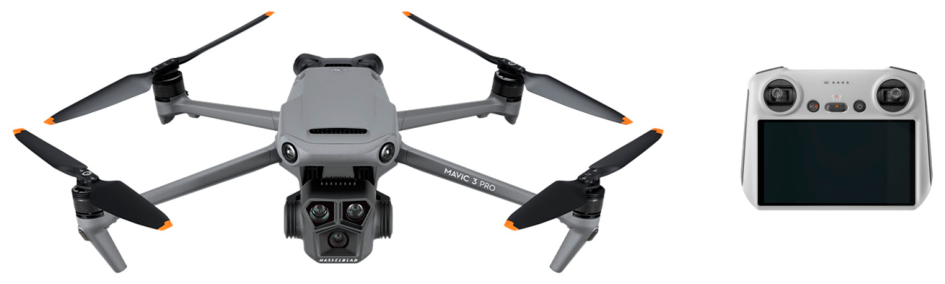
Figure 5.
Relative abundance of Hein agroforest rattan species. CAS: Calamus deerratus; ERA: Eremospatha macrocarpa; ERI: Eremospatha dransfieldii; LAE: Laccosperma laeve; LAM: Laccosperma secundiflorum.
Figure 5.
Relative abundance of Hein agroforest rattan species. CAS: Calamus deerratus; ERA: Eremospatha macrocarpa; ERI: Eremospatha dransfieldii; LAE: Laccosperma laeve; LAM: Laccosperma secundiflorum.
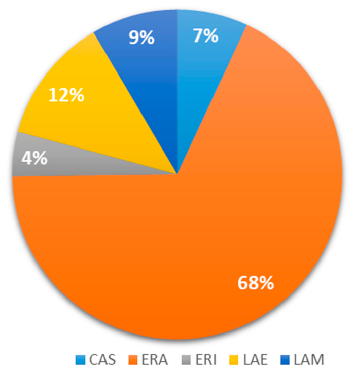
Figure 6.
Distribution of rattan individuals across development growth stages.
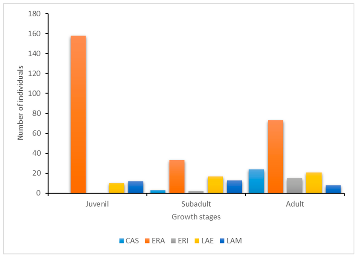
Figure 7.
Visual identification of rattan species from drone imagery and orthomosaics. For each species left-hand pictures show raw imagery and right-hand pictures show orthomosaics extracts. (A) – (B): Calamus deerratus, (C) – (D) : Eremospatha macrocarpa.
Figure 7.
Visual identification of rattan species from drone imagery and orthomosaics. For each species left-hand pictures show raw imagery and right-hand pictures show orthomosaics extracts. (A) – (B): Calamus deerratus, (C) – (D) : Eremospatha macrocarpa.
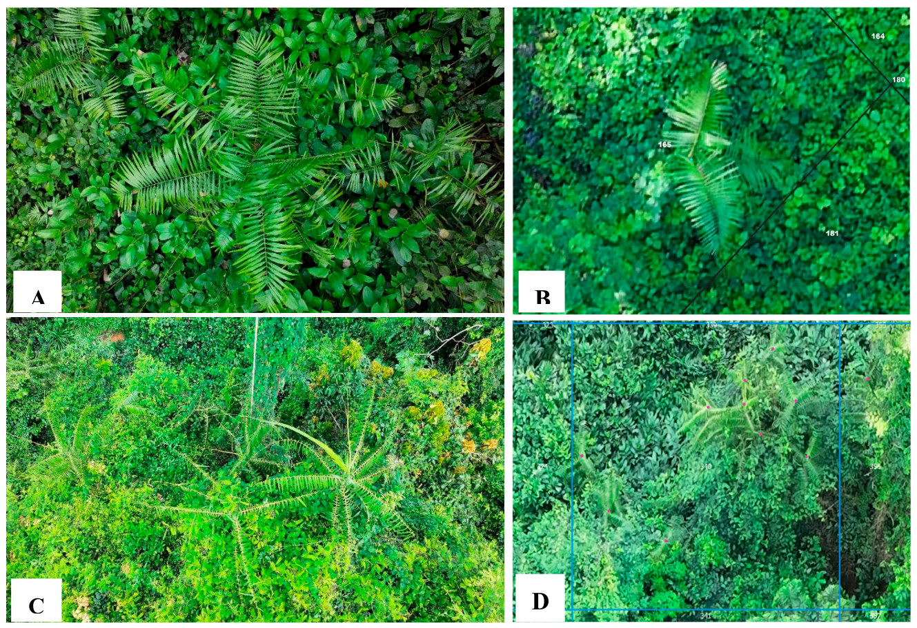
Figure 8.
Visual identification of rattan species from drone imagery and orthomosaics. For each species left-hand pictures show raw imagery and right-hand pictures show orthomosaics extracts. (E)-(F): Eremospatha dransfieldii, (G)-(H): Laccosperma secundiflorum.
Figure 8.
Visual identification of rattan species from drone imagery and orthomosaics. For each species left-hand pictures show raw imagery and right-hand pictures show orthomosaics extracts. (E)-(F): Eremospatha dransfieldii, (G)-(H): Laccosperma secundiflorum.
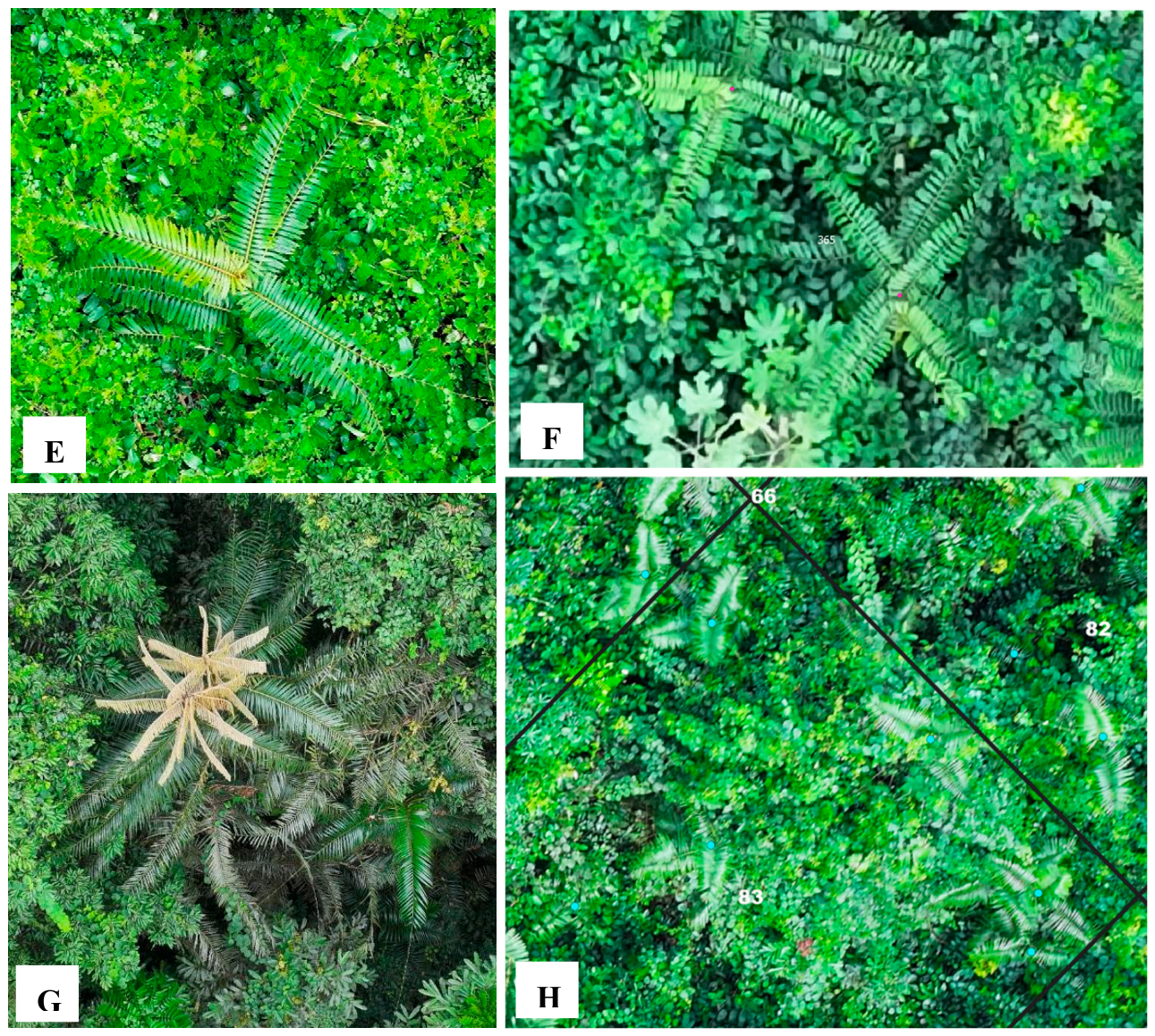
Figure 9.
Relationship between ground -based and drone-based inventory counts. Each point represents one paired observation. The solid blue line shows the perfect monotonic trend. Spearman’s ρ = 1.00 (n = 32), reflecting a complete rank-order agreement between the two methods.
Figure 9.
Relationship between ground -based and drone-based inventory counts. Each point represents one paired observation. The solid blue line shows the perfect monotonic trend. Spearman’s ρ = 1.00 (n = 32), reflecting a complete rank-order agreement between the two methods.
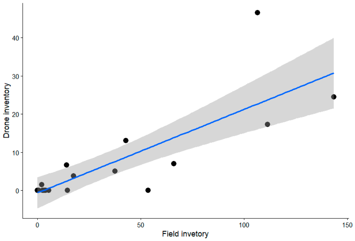
Figure 10.
Bland-Altman plot comparing ground based, and drone-based density estimates with mean bias (solid red line) of -25.22 and limits agreement ranging from -92.96 to 42.52 ramets/ha.
Figure 10.
Bland-Altman plot comparing ground based, and drone-based density estimates with mean bias (solid red line) of -25.22 and limits agreement ranging from -92.96 to 42.52 ramets/ha.
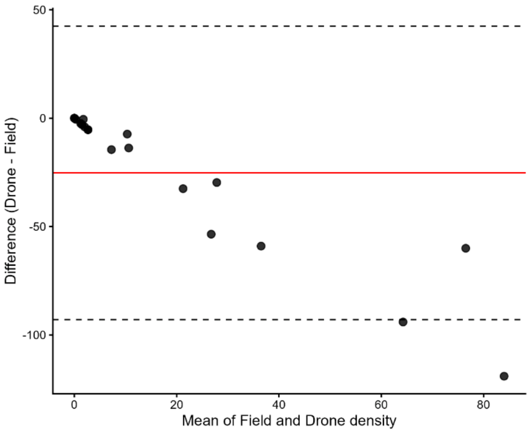

Table 1.
Main orthomosaic processing workflow parameters.
| Parameters | Setting |
| Alignment | Accuracy: High |
| Generic preselection: Yes Reference preselection: Source Key point limit: 40,000 Key point limit per Mpx: 1,000 Tie point limit: 4,000 Exclude stationary tie points: Yes, Guided image matching: No Adaptive camera model fitting: No Apply masks to: None | |
| Dense cloud | Quality: High Filtering mode: Mild |
| Mesh | Surface type: Arbitrary Source data: Depth maps Interpolation: Enabled |
| Texture | Mapping mode: Generic Blending mode: Mosaic Enable hole filling: Yes Enable ghosting filter: Yes |
| Digital Elevation Model | Source data: Point cloud Interpolation: Enabled |
| Orthomosaic | Blending mode: Mosaic Surface: DEM Enable hole filling: Yes Enable ghosting filter: No |
Table 2.
Genet and ramet densities (individuals per hectare) recorded for the five rattan species inventoried in the study area.
Table 2.
Genet and ramet densities (individuals per hectare) recorded for the five rattan species inventoried in the study area.
| Species |
Genets density (ind/ha) |
Ramets density (ind/ha) |
| Calamus deerratus | 02 | 19 |
| Eremospatha macrocarpa | 24 | 90 |
| Eremospatha dransfieldii | 02 | 11 |
| Laccosperma laeve | 04 | 15 |
| Laccosperma secundiflorum | 03 | 09 |
| Total | 35 | 145 |
Disclaimer/Publisher’s Note: The statements, opinions and data contained in all publications are solely those of the individual author(s) and contributor(s) and not of MDPI and/or the editor(s). MDPI and/or the editor(s) disclaim responsibility for any injury to people or property resulting from any ideas, methods, instructions or products referred to in the content. |
© 2026 by the authors. Licensee MDPI, Basel, Switzerland. This article is an open access article distributed under the terms and conditions of the Creative Commons Attribution (CC BY) license (http://creativecommons.org/licenses/by/4.0/).
Copyright: This open access article is published under a Creative Commons CC BY 4.0 license, which permit the free download, distribution, and reuse, provided that the author and preprint are cited in any reuse.