
Submitted:
11 August 2026
Posted:
13 August 2026
You are already at the latest version
Abstract
Bangladesh faces three interlocking water quality crises: naturally occurring arsenic in shallow groundwater, salinity intrusion across the coastal southwest, and severe industrial and domestic pollution of the rivers around Dhaka. Conventional monitoring is too sparse, slow, and costly to manage these problems at national scale. This paper critically reviews how artificial intelligence (AI), and machine learning (ML) in particular, is being used to assess and improve water quality in the specific hydrological, climatic, and institutional context of Bangladesh, and asks what is still missing. We synthesise recent studies on arsenic risk mapping, coastal salinity forecasting, river water-quality-index (WQI) prediction, satellite and Internet-of-Things monitoring, and treatment optimisation, and summarise the governing equations of the dominant methods: tree ensembles, recurrent and physics-informed neural networks, and explainable AI. Reported performance commonly exceeds 0.9 (R²) for WQI regression and 0.9 accuracy for arsenic classification, yet most studies remain single-problem, single-region, and weakly validated across the monsoon cycle. We argue that the decisive gap is integration, and propose a national framework linking Bangladesh's monitoring agencies, remote sensing, and low-cost sensors to interpretable models and concrete management actions. We critically examine the principal barriers (data scarcity, seasonality, transferability, interpretability, and deployment capacity) and offer a prioritised research and policy roadmap aligned with Sustainable Development Goal 6. The contribution is a Bangladesh-specific synthesis and an actionable, interpretability-centred roadmap.
Keywords:
Bangladesh
; artificial intelligence
; machine learning
; groundwater arsenic
; salinity intrusion
; water quality index
1. Introduction
Access to safe water is a foundational determinant of public health and economic development, yet for Bangladesh it remains precarious. The country sits on the world’s largest delta, formed by the Ganges, Brahmaputra (Jamuna), and Meghna rivers, and is simultaneously water-abundant and water-insecure. Three problems dominate. First, the shift from microbially unsafe surface water to groundwater tube wells in the late twentieth century unintentionally exposed the population to naturally occurring arsenic, in what has been described as one of the largest mass poisonings in history. Second, sea-level rise, reduced dry-season river flow, and the expansion of brackish-water shrimp aquaculture have driven salinity intrusion deep into the coastal southwest, contaminating both surface and groundwater. Third, rapid, poorly regulated industrialisation has turned the rivers around Dhaka — the Buriganga, Turag, Balu, and Tongi Khal — into heavily polluted channels with dissolved oxygen near zero in the dry season [1]. Figure 1 locates these three challenge zones.
Managing these problems demands dense, timely, and spatially comprehensive information that conventional sampling cannot provide. Laboratory analysis of arsenic or salinity across millions of wells is infeasible to repeat frequently, and the physico-chemical drivers are highly non-linear, seasonal, and spatially heterogeneous. Artificial intelligence offers a route to extend limited measurements: by learning the relationship between cheaply observed predictors and expensive or future targets, ML models can map contamination risk, forecast seasonal deterioration, and support real-time decisions [1,3]. A growing body of Bangladesh-specific work — spanning arsenic prediction in the northwest [3], coastal-aquifer modelling [4], and WQI prediction for Dhaka’s rivers [1] — demonstrates that these methods are both accurate and locally relevant.
This paper has three objectives: (i) to characterise the three water-quality challenges of Bangladesh and the data landscape available for modelling them; (ii) to review, with their governing equations, the AI methods now being applied and the performance they achieve; and (iii) to propose an integrated, interpretable, and deployable AI framework, together with a research and policy roadmap, tailored to Bangladesh’s institutions and aligned with Sustainable Development Goal 6 (clean water and sanitation). Unlike global reviews, the emphasis throughout is on the specific hydroclimatic and governance context of Bangladesh.
2. Water-Quality Challenges in Bangladesh
2.1. Groundwater Arsenic
Arsenic enters Bangladesh’s shallow aquifers through the reductive dissolution of arsenic-bearing iron oxyhydroxides in Holocene alluvial sediments, a process favoured by reducing, organic-rich conditions [3]. Concentrations are spatially erratic, so that adjacent wells can differ by an order of magnitude, which makes blanket testing impractical and statistical prediction attractive. The World Health Organization guideline value is 10 µg L−1, whereas the Bangladesh national standard is 50 µg L−1 [18,19]; large populations are exposed above one or both thresholds, with elevated arsenic frequently co-occurring with iron, manganese, phosphate, and bicarbonate [3,4].
2.2. Coastal Salinity Intrusion
In the southwest coastal belt — Khulna, Satkhira, and Bagerhat — freshwater availability is increasingly limited by salinity. Drivers include sea-level rise, diminished upstream dry-season flow, tidal propagation up estuaries, cyclonic storm surge, and the conversion of paddy land to brackish shrimp ponds. Rising salinity degrades drinking-water sources and agricultural soils and is linked to adverse health outcomes. Because salinity varies strongly with season and tide, it is well suited to time-series forecasting once sufficient electrical-conductivity records are assembled [4,5].
2.3. River and Surface-Water Pollution
The rivers encircling Dhaka receive untreated effluent from thousands of tanneries, textile and dyeing units, and dense domestic discharge. Measurements show extreme organic loading, high ammonia, and dissolved oxygen approaching zero in the dry season [1]. Recent ML studies of the Buriganga, Balu, Tongi Khal, and Turag report that most physico-chemical parameters exceed permissible limits, placing average water quality in the lowest category and rendering the water unfit for domestic use [1,7]. Table 1 lists the parameters most relevant to these three problems together with the applicable Bangladesh and WHO thresholds.
3. Data Sources and AI Methods
3.1. Data Landscape in Bangladesh
Modelling depends on data from several national and external sources: the Department of Public Health Engineering (DPHE) and the British Geological Survey legacy surveys for groundwater arsenic; the Bangladesh Water Development Board (BWDB) for river stage, flow, and salinity; the Department of Environment (DoE) for surface-water quality; agricultural agencies for coastal salinity; and freely available satellite imagery (Sentinel-2/3, Landsat) for optical retrieval. Increasingly, low-cost IoT sensors measuring pH, electrical conductivity, turbidity, and total dissolved solids supply high-frequency streams [6,11]. These sources are heterogeneous, unevenly distributed, and gap-prone, so pre-processing — cleaning, imputation, feature engineering, and normalisation — is a critical and often decisive step. A common min–max normalisation rescales each predictor,
so that variables of differing magnitude contribute comparably to the learner.
3.2. The Water-Quality Index
For rivers, the weighted-arithmetic water-quality index (WQI) is the most common aggregate target,
where the quality rating and weight of the i-th parameter are
with Ci the observed concentration, Si the permissible standard from Table 1, C0 the ideal value, and k a constant. Studies then pose either WQI regression or water-quality-class classification [1].
3.3. Learning Algorithms
Tree ensembles dominate tabular water-quality prediction in Bangladesh. The random forest averages an ensemble of decorrelated trees,
where Tb is the b-th of B trees [13]; gradient-boosted variants (XGBoost, CatBoost) build trees sequentially to correct residual error [14]. For temporal problems such as salinity, the long short-term memory (LSTM) network captures long-range dependencies through gated recurrence [15], and has been combined with process knowledge in physics-informed neural networks (PINNs) that add the governing advection–dispersion–reaction residual to the loss,
where Ĉ is the predicted concentration, u velocity, D dispersion, kR a reaction term, and λ balances data and physics. PINNs improve generalisation where labelled data are scarce — a recurring constraint in Bangladesh — and were central to the first integrated explainable framework for the monsoon-driven Padma River Basin [2,17].
3.4. Evaluation and Interpretability
Regression skill is reported with the root-mean-square error, mean absolute error,
and the coefficient of determination,
with the Nash–Sutcliffe efficiency (NSE) sharing the same form. Because predictions inform public-health and regulatory decisions, interpretability is essential. SHAP values, grounded in cooperative game theory, decompose each prediction additively into feature contributions,
where φj is the contribution of feature j and φ0 the baseline [16]. Such attribution lets analysts confirm that an arsenic model relies on geochemically plausible drivers rather than spurious correlations. The complete pipeline, tailored to Bangladesh, is shown in Figure 2.
4. AI Applications for Bangladesh
This section reviews five application clusters, summarised with reported performance in Table 2.
4.1. Arsenic Risk Prediction and Mapping
Predicting whether a well exceeds an arsenic threshold from cheaper geochemical and spatial predictors is among the most valuable applications. In Chapainawabganj, a comparison of naïve Bayes, random forest, support-vector machine, decision tree, and logistic regression identified pH, electrical conductivity, sulphate, nitrate, iron, manganese, sodium, and bicarbonate as informative features and produced spatial arsenic-occurrence maps to guide mitigation [3]. In the coastal region, multiple ML algorithms were trained on comprehensive water-quality parameters to predict arsenic that ranged widely from 0.01 to 0.72 mg L−1 [4]. Explainable analysis of such models consistently surfaces reductive-dissolution drivers — iron, redox state, depth, and phosphate — as dominant, as illustrated in Figure 4. These risk maps let limited testing budgets be directed to the highest-risk areas.
4.2. Coastal Salinity Forecasting
Salinity is strongly seasonal, peaking in the dry pre-monsoon months as freshwater flow recedes and tidal influence advances. Recurrent and physics-informed models can learn this cycle and project short-horizon salinity from meteorological and hydrological drivers, supporting planning of safe-water provision, rainwater harvesting, and managed aquifer recharge [4,5]. Figure 5 shows an illustrative forecast in which an LSTM anticipates the seasonal rise and crossing of an irrigation threshold, with an uncertainty band — an output type that is far more actionable than a single point estimate.
4.3. River Water-Quality-Index Prediction
For Dhaka’s rivers, a recent study compared fourteen ML models to predict the WQI of the Buriganga, Balu, Tongi Khal, and Turag. An artificial neural network gave the best skill, with a root-mean-square error of 2.34, mean absolute error of 1.24, Nash–Sutcliffe efficiency of 0.97, and R2 of 0.97, with random forest also performing strongly; the authors emphasise the cost-effectiveness gained by coupling feature selection with ML [1]. In the monsoon-driven Padma Basin, an integrated framework combining ML, deep learning, and PINNs with explainable analysis and probabilistic uncertainty quantification was used to predict, interpret, and spatially regionalise seasonal WQI dynamics [2]. Figure 3 summarises the indicative performance envelope across such Bangladesh studies.
4.4. Satellite and IoT Monitoring
Remote sensing extends observation to whole river reaches and ungauged waters. For the Buriganga, optical indices for coloured dissolved organic matter, chlorophyll, and floating algae were derived from imagery and forecast with random-forest and LSTM models, keeping errors within an acceptable range and confirming heavy organic pollution [7]. Comparable hybrid pipelines — physically based retrieval feeding gradient-boosting and time-series models — have mapped chlorophyll-a in the shared Ganges system with high accuracy [8]. At ground level, low-cost IoT systems built on inexpensive microcontrollers and pH, turbidity, total-dissolved-solids, and temperature sensors stream data to ML classifiers for real-time safety screening, including for drinking water in tourist areas [6,11]. Together these technologies move monitoring from sparse snapshots toward continuous, spatially complete coverage.
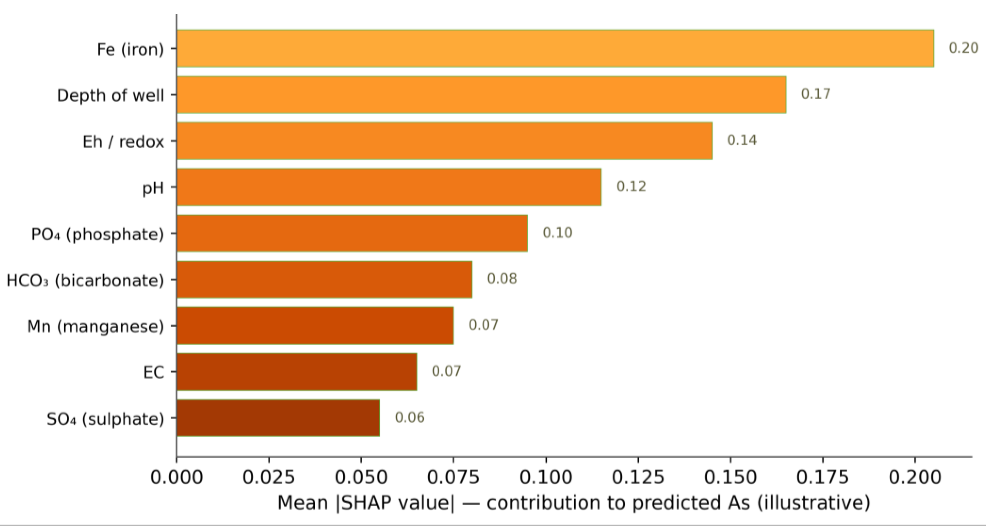
Figure 4.
Explainable-AI (SHAP-style) attribution of groundwater-arsenic prediction to its geochemical drivers. The ranking is illustrative but consistent with the reductive-dissolution mechanism that controls arsenic mobilisation in Bangladesh aquifers.
Figure 4.
Explainable-AI (SHAP-style) attribution of groundwater-arsenic prediction to its geochemical drivers. The ranking is illustrative but consistent with the reductive-dissolution mechanism that controls arsenic mobilisation in Bangladesh aquifers.
4.5. Treatment and Early Warning
Beyond assessment, AI supports intervention. ML models guide the design and operation of arsenic- and iron-removal units and predict removal efficiency from operating conditions, while anomaly-detection and forecasting systems provide early warning of pollution episodes and effluent non-compliance [9,10]. Reviews of AI-based detection and control for river pollution highlight the shift from reactive measurement toward predictive, automated management [10]. Interpretable deep reinforcement learning has improved the operation of urban drainage systems, cutting untreated discharges while keeping the control logic auditable [12] — directly relevant to Dhaka’s overburdened drainage and frequent overflows. For Bangladesh, the highest near-term value lies in targeting scarce treatment and testing resources where models indicate the greatest risk.
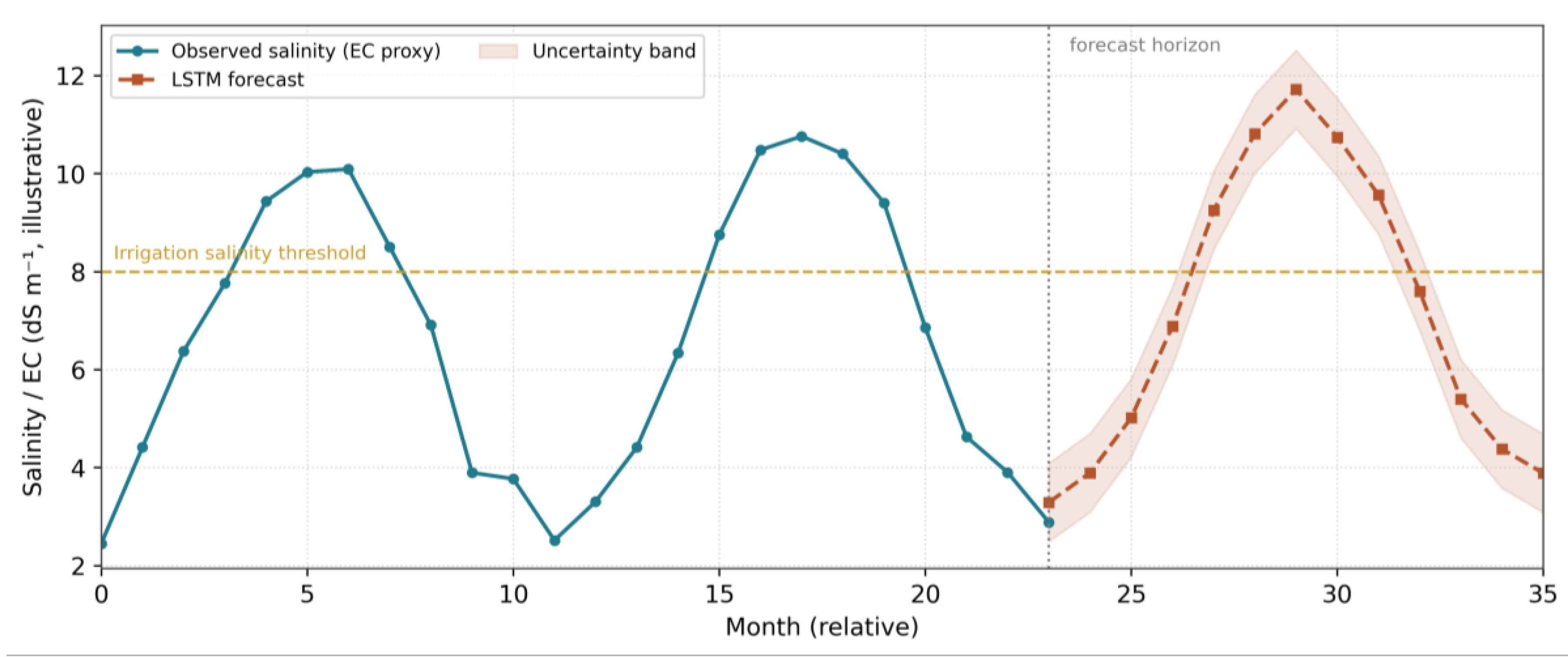
Figure 5.
Illustrative seasonal salinity-intrusion forecast for coastal Bangladesh. An LSTM-type model anticipates the dry-season rise and the crossing of an irrigation-salinity threshold, with an uncertainty band supporting risk-based planning. Synthetic data shown for illustration.
Figure 5.
Illustrative seasonal salinity-intrusion forecast for coastal Bangladesh. An LSTM-type model anticipates the dry-season rise and the crossing of an irrigation-salinity threshold, with an uncertainty band supporting risk-based planning. Synthetic data shown for illustration.
5. An Integrated AI Roadmap for Bangladesh
The reviewed studies are individually strong but fragmented: each addresses a single problem, region, or model. We argue that the next advance for Bangladesh is integration — connecting the three challenges to shared data infrastructure, interpretable models, and decision channels (Figure 6). Table 3 maps each challenge to suitable AI methods, the data they require, and the management outcome they enable.
6. Challenges and Limitations
Data scarcity and quality. Long, consistent, openly accessible records are rare in Bangladesh. Monitoring is unevenly distributed, instruments and laboratories vary, and many historical arsenic surveys are now dated. Models trained on small or biased samples risk overfitting and poor real-world skill [3,5].
Monsoon seasonality and non-stationarity. Hydroclimatic forcing produces strong wet–dry contrasts and inter-annual variability; a model fitted to one season or year may fail in another. Explicitly seasonal and physics-informed designs help, but demonstrating skill across the monsoon cycle remains essential [2].
Transferability. Arsenic geochemistry and pollution regimes differ between basins, so a model calibrated in the northwest will not automatically transfer to the coast. Validation on independent districts — not merely held-out samples — is the meaningful test [3,4].
7. Future Directions and Policy Recommendations
Realising the framework of Section 5 depends as much on institutions as on algorithms. Table 4 sets out prioritised recommendations spanning data, methods, deployment, and governance.
Methodologically, the most promising directions are physics-informed and explainable models that generalise from few labels [2,17]; data-assimilation and edge-AI architectures that fuse IoT streams with forecasts for real-time warning; and foundation or transfer-learning approaches that exploit data from data-rich basins to bootstrap models in data-poor districts. Each directly targets the data-scarcity and transferability barriers that most constrain Bangladesh.
8. Conclusion
Bangladesh’s water-quality crises — arsenic, salinity, and river pollution — are too large, too dynamic, and too spatially heterogeneous for conventional monitoring alone. The recent literature reviewed here shows that artificial intelligence already delivers accurate, locally validated tools: machine-learning models predict the water-quality index of Dhaka’s rivers with R2 near 0.97 [1]; explainable and physics-informed frameworks interpret seasonal dynamics in the Padma Basin [2]; and ML risk maps and forecasts target arsenic and salinity where testing budgets are scarce [3,4]. The decisive next step is integration — linking the country’s monitoring agencies, remote sensing, and low-cost sensors to interpretable models and concrete decisions, as set out in the framework and roadmap proposed here. With investment in open data, calibrated sensing, transparent methods, and local capacity, AI can become not merely a means of observing Bangladesh’s water but a practical lever for improving it, in direct service of Sustainable Development Goal 6.
Acknowledgements
The authors thank Daffodil International University, Bangladesh and Lamar University, USA for their support.
Author Contributions
Priasa Akther: Conceptualization, Methodology, Investigation, Writing — original draft, Visualization. Md Mahmud: Conceptualization, Supervision, Writing — review and editing. S M Rakibul Islam: Methodology, Investigation, Writing — original draft, Visualization. Md Rubayet Islam: Methodology, Investigation, Writing — original draft. Md Abdul Qader: Methodology, Investigation, Writing — original draft, Visualization. All authors have read and agreed to the published version of the manuscript. Arif Mia: Methodology, Investigation, Writing — original draft, Visualization , Abdullah Al Maimun and Md Mahbubur Rahman Akash: Methodology, Investigation, Writing — original draft, Visualization.
Funding
This research did not receive any specific grant from funding agencies in the public, commercial, or not-for-profit sectors.
Conflicts of Interest
The authors declare that they have no known competing financial interests or personal relationships that could have appeared to influence the work reported in this paper.
Declaration of Generative AI and AI-Assisted Technologies in the Manuscript Preparation Process
During the preparation of this work, the author(s) did not use a generative AI assistant to draft or structure any portion of the text or to produce schematic figures.
References
- Nishat, M.H., Khan, M.H.R.B., Ahmed, T., Hossain, S.N., Ahsan, A., El-Sergany, M.M., Shafiquzzaman, Md., Imteaz, M.A., Alresheedi, M.T. Comparative analysis of machine learning models for predicting water quality index in Dhaka’s rivers of Bangladesh. Environmental Sciences Europe 2025, 37(1), 31. [CrossRef]
- Explainable and physics-informed machine learning for seasonal water quality prediction in the monsoon-driven Padma River Basin, Bangladesh. Environmental Geochemistry and Health 2026. [CrossRef]
- Khatun, M.F., Reza, A.H.M.S., Sattar, G.S., Khan, A.S., Khan, M.I.A. Prediction of arsenic concentration in groundwater of Chapainawabganj, Bangladesh: machine learning-based approach to spatial modeling. Environmental Science and Pollution Research 2024, 31, 46023–46037. [CrossRef]
- Machine learning prediction of groundwater arsenic contamination using water quality parameters in the coastal region of Bangladesh. Environmental Geochemistry and Health 2025. [CrossRef]
- From data to decision: leveraging machine learning and water quality index for groundwater quality evaluation. Sustainable Water Resources Management 2025. [CrossRef]
- An IoT-enabled intelligent water quality monitoring system for tourist safety using machine learning (Bangladesh), 2025. https://discovery.researcher.life/article/an-iot-enabled-intelligent-water-quality-monitoring-system-for-tourist-safety-using-machine-learning/a410e18984ad3ebe9f07f02bb2ef37d9.
- Water quality monitoring of the Buriganga River, Dhaka: forecasting of optical indices using random-forest regression and LSTM. In: Proc. International Conference on Civil Engineering Innovation (ICCEI 2025). https://icceiruet.org/.
- Kandasamy, L., Mahendran, A., Sangaraju, S.H.V., Mathur, P., Faldu, S.V., Mazzara, M. Enhanced remote sensing and deep learning aided water quality detection in the Ganges River, India. Results in Engineering 2025, 25, 103604. [CrossRef]
- A review of machine learning and internet-of-things on water quality assessment: methods, applications and future trends. Results in Engineering 2025. https://www.sciencedirect.com/science/article/pii/S2590123025012575.
- Artificial intelligence based detection and control strategies for river water pollution: a comprehensive review. Journal of Contaminant Hydrology 2025. https://www.sciencedirect.com/science/article/pii/S0169772225000464.
- A deep learning–IoT integrated framework for real-time groundwater quality monitoring and prediction in urban aquifers. Groundwater for Sustainable Development 2025. https://www.sciencedirect.com/science/article/pii/S2214714425021257.
- Tian, W., Fu, G., Xin, K., Zhang, Z., Liao, Z. Improving the interpretability of deep reinforcement learning in urban drainage system operation. Water Research 2024, 249, 120912. [CrossRef]
- Breiman, L. Random forests. Machine Learning 2001, 45, 5–32. [CrossRef]
- Chen, T., Guestrin, C. XGBoost: a scalable tree boosting system. In: Proc. 22nd ACM SIGKDD, 2016, pp. 785–794. [CrossRef]
- Hochreiter, S., Schmidhuber, J. Long short-term memory. Neural Computation 1997, 9(8), 1735–1780. [CrossRef]
- Lundberg, S.M., Lee, S.-I. A unified approach to interpreting model predictions. In: Advances in Neural Information Processing Systems 30, 2017.
- Raissi, M., Perdikaris, P., Karniadakis, G.E. Physics-informed neural networks. Journal of Computational Physics 2019, 378, 686–707. [CrossRef]
- World Health Organization. Guidelines for Drinking-water Quality, 4th ed. incorporating the first and second addenda. WHO, Geneva, 2022.
- Department of Environment (DoE), Government of Bangladesh. Environmental Conservation Rules, 1997 (and subsequent amendments). Ministry of Environment, Forest and Climate Change, Dhaka.
Figure 1.
Schematic map of Bangladesh showing the three dominant water-quality challenges addressed in this review: groundwater arsenic in the northwest, river pollution around Dhaka, and coastal salinity intrusion in the southwest. Zones are indicative and not drawn to cartographic scale. Map lines delineate study areas and do not necessarily depict accepted national boundaries.
Figure 1.
Schematic map of Bangladesh showing the three dominant water-quality challenges addressed in this review: groundwater arsenic in the northwest, river pollution around Dhaka, and coastal salinity intrusion in the southwest. Zones are indicative and not drawn to cartographic scale. Map lines delineate study areas and do not necessarily depict accepted national boundaries.
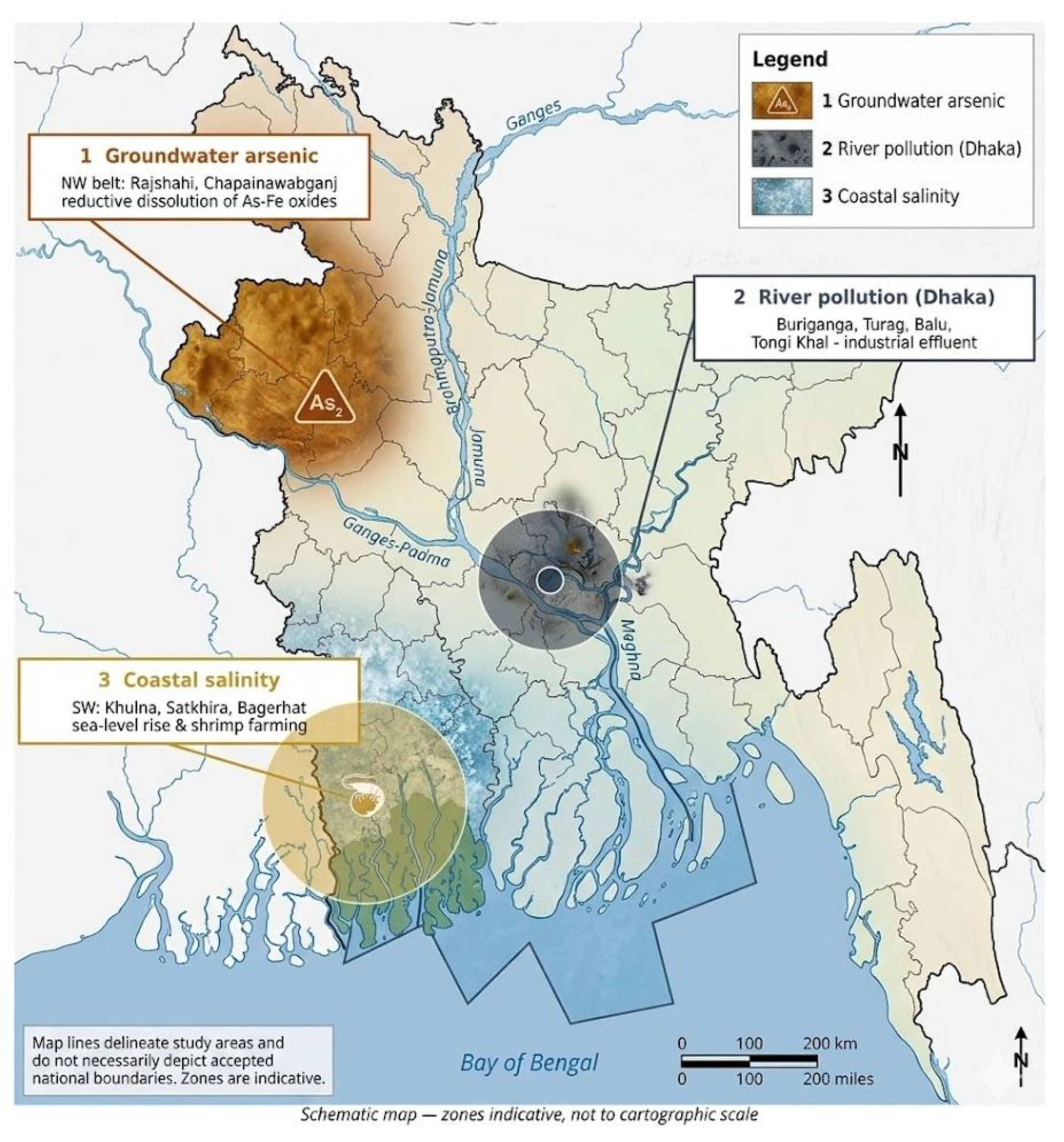
Figure 2.
Proposed integrated AI framework for water-quality improvement in Bangladesh, linking national and remote-sensing data sources through AI/ML methods and applications to outcomes aligned with Sustainable Development Goal 6.
Figure 2.
Proposed integrated AI framework for water-quality improvement in Bangladesh, linking national and remote-sensing data sources through AI/ML methods and applications to outcomes aligned with Sustainable Development Goal 6.
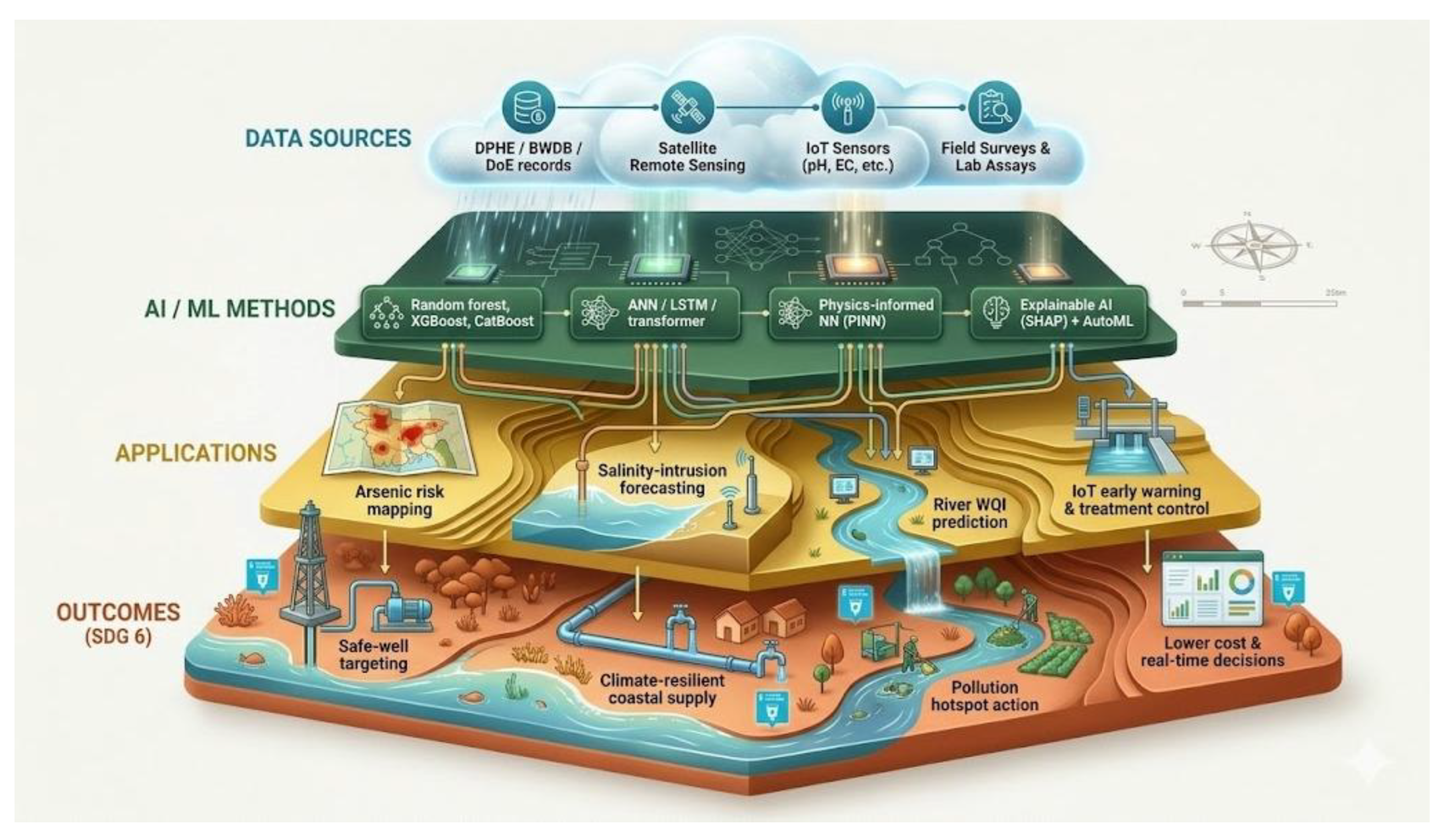
Figure 3.
Representative performance of ML models on Bangladesh water-quality tasks: (a) indicative coefficient of determination for WQI/parameter regression; (b) indicative accuracy and F1-score for groundwater-arsenic class prediction. Values are indicative ranges synthesised from recent studies rather than results from a single dataset.
Figure 3.
Representative performance of ML models on Bangladesh water-quality tasks: (a) indicative coefficient of determination for WQI/parameter regression; (b) indicative accuracy and F1-score for groundwater-arsenic class prediction. Values are indicative ranges synthesised from recent studies rather than results from a single dataset.
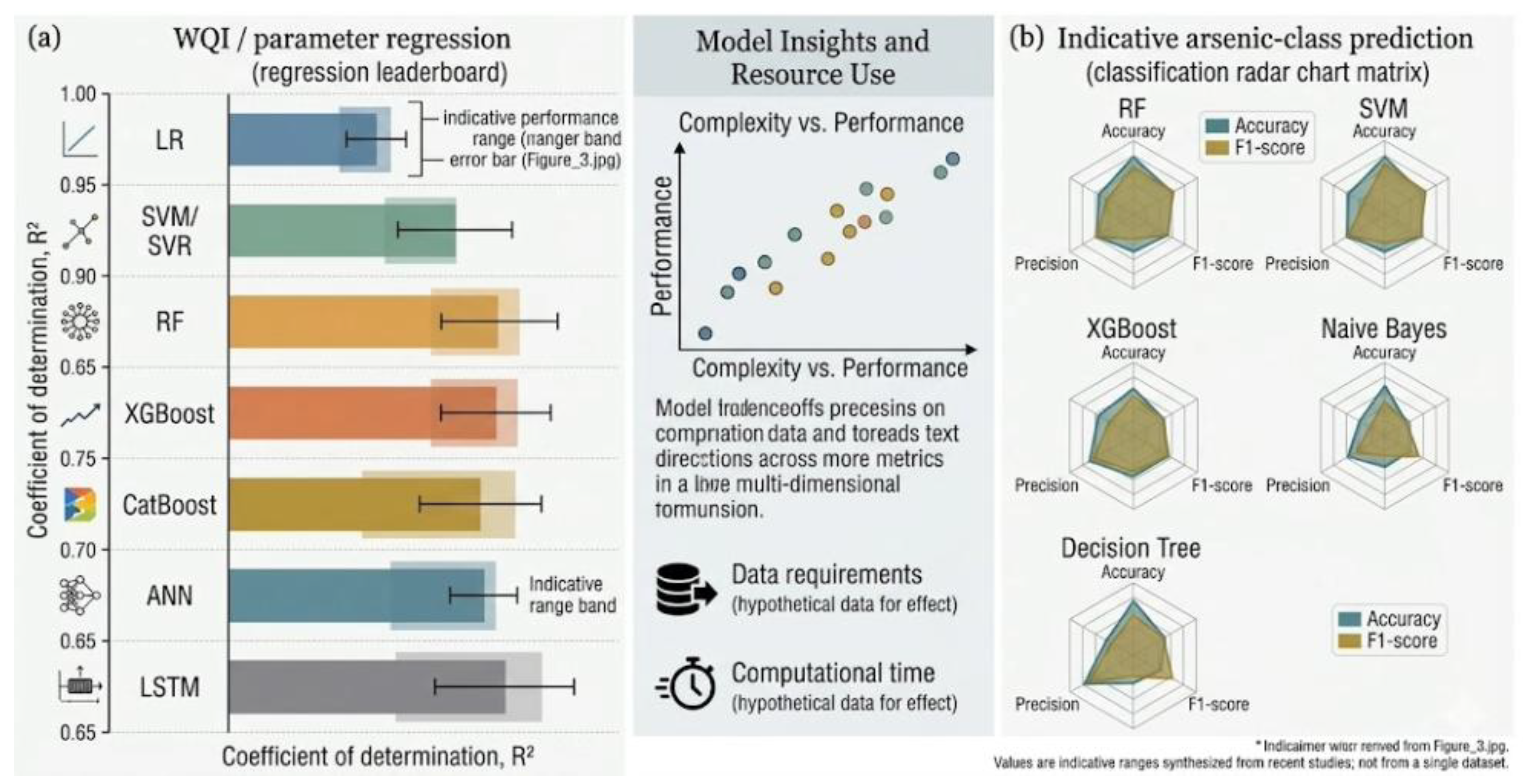
Figure 6.
From challenge to action: an integrated AI roadmap that links Bangladesh’s three water-quality challenges through AI solutions to management outcomes contributing to Sustainable Development Goal 6, underpinned by shared enablers.
Figure 6.
From challenge to action: an integrated AI roadmap that links Bangladesh’s three water-quality challenges through AI solutions to management outcomes contributing to Sustainable Development Goal 6, underpinned by shared enablers.
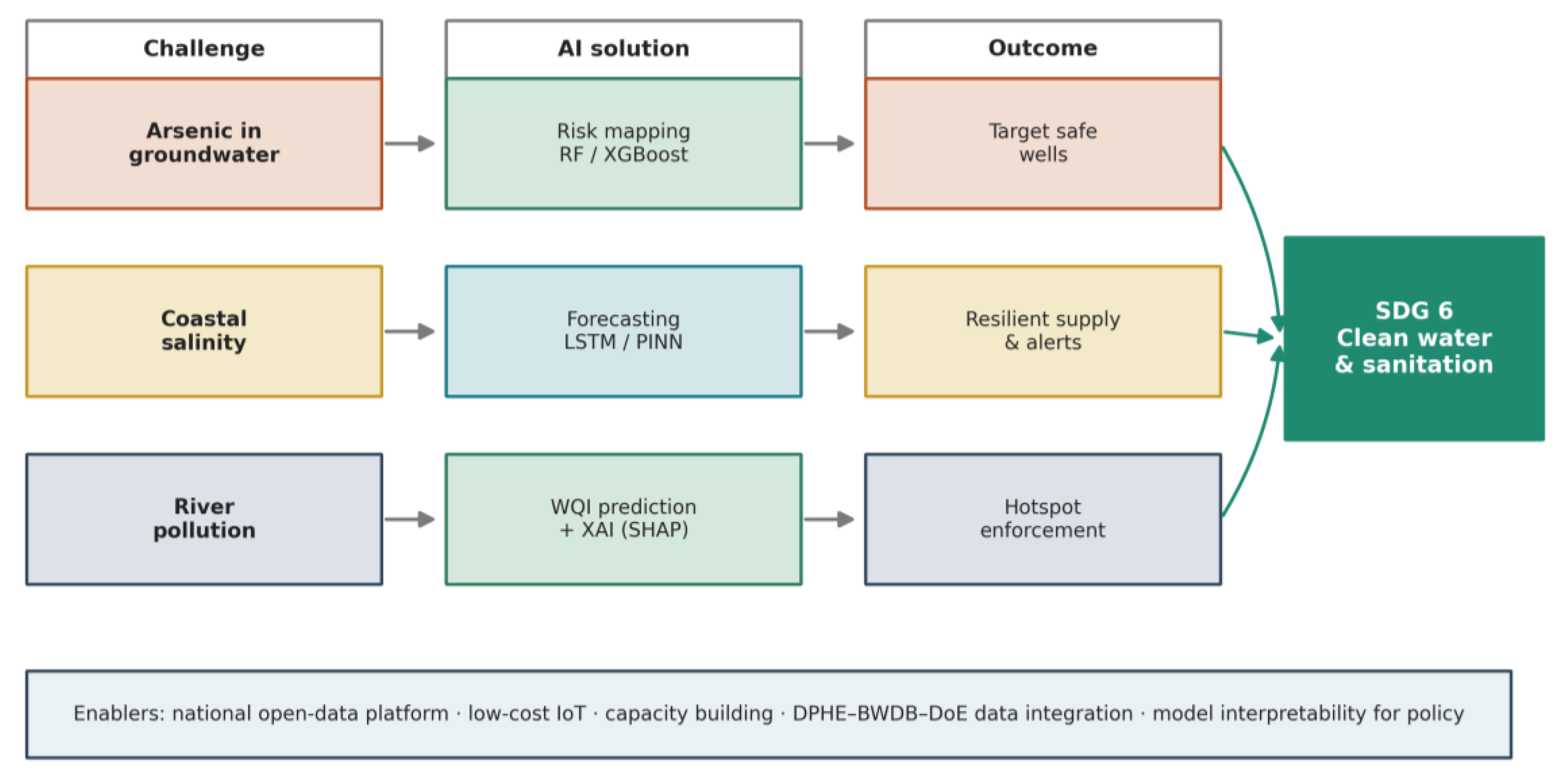

Table 1.
Key water-quality parameters for Bangladesh with World Health Organization (WHO) drinking-water guideline values and Bangladesh Department of Environment (DoE) standards. Values are nominal and intended for orientation; readers should consult the current WHO and DoE documents for authoritative limits.
Table 1.
Key water-quality parameters for Bangladesh with World Health Organization (WHO) drinking-water guideline values and Bangladesh Department of Environment (DoE) standards. Values are nominal and intended for orientation; readers should consult the current WHO and DoE documents for authoritative limits.
| Parameter | Unit | WHO Guide | BD (DoE) | Relevance in Bangladesh |
| Arsenic (As) | µg L−1 | 10 | 50 | Primary groundwater health hazard (NW belt) |
| Chloride/salinity | mg L−1 | 250 | 150–600 | Coastal salinity intrusion indicator |
| Electrical conductivity | µS cm−1 | – | – | Salinity surrogate; cheap, IoT-friendly |
| Dissolved oxygen | mg L−1 | – | ≥5–6 | Near zero in polluted Dhaka rivers |
| pH | – | 6.5–8.5 | 6.5–8.5 | Controls metal solubility and toxicity |
| Iron (Fe) | mg L−1 | 0.3 * | 0.3–1.0 | Co-occurs with arsenic mobilisation |
| Manganese (Mn) | mg L−1 | 0.08 | 0.1 | Common groundwater co-contaminant |
| Nitrate (as N) | mg L−1 | 50 | 10 | Agricultural runoff indicator |
| Turbidity | NTU | ≤5 | 10 | Surface-water clarity; coagulation driver |
Table 2.
Representative recent (2024–2026) AI studies on water quality in Bangladesh and the shared Ganges–Brahmaputra–Meghna system. Performance is as reported by the respective authors.
Table 2.
Representative recent (2024–2026) AI studies on water quality in Bangladesh and the shared Ganges–Brahmaputra–Meghna system. Performance is as reported by the respective authors.
| Region/Water Body | Target | Models | Best Result | Ref |
| Dhaka rivers (Buriganga, Turag, Balu) | River WQI | 14 ML incl. ANN, RF, XGBoost, CatBoost | ANN: R2 0.97, NSE 0.97 | [1] |
| Padma River Basin | Seasonal WQI | ML + DL + PINN + XAI | Interpretable, uncertainty-aware | [2] |
| Chapainawabganj (NW) | Groundwater As | NB, RF, SVM, DT, LR | Spatial As risk maps | [3] |
| Coastal region | Groundwater As | Multiple ML on WQPs | As 0.01–0.72 mg L−1 modelled | [4] |
| Groundwater (WQI) | Groundwater quality | ML + WQI | Decision-support mapping | [5] |
| Tourist areas | Potability screening | IoT + ML (ESP32 sensors) | Real-time classification | [6] |
| Buriganga (remote sensing) | Optical indices | RFR, LSTM | Error 1–13% | [7] |
| Ganges system | Chlorophyll-a | QAA-v5 + CatBoost + NBeats | CatBoost R2 ≈ 0.985 | [8] |
WQP, water-quality parameter; NB, naïve Bayes; DT, decision tree; LR, logistic regression; RFR, random-forest regression.
Table 3.
Mapping of Bangladesh water-quality challenges to AI methods, data requirements, and target outcomes.
Table 3.
Mapping of Bangladesh water-quality challenges to AI methods, data requirements, and target outcomes.
| Challenge | Suitable AI Methods | Key Data Needs | Target Outcome |
| Groundwater arsenic | RF/XGBoost classification; spatial ML; SHAP | Geochemistry, well depth, geology, location | Risk maps to target safe wells and testing |
| Coastal salinity | LSTM/transformer; PINN; uncertainty quantification | EC/salinity time series, flow, tide, climate | Seasonal forecasts and early warning |
| River pollution | ANN/RF WQI models; remote-sensing retrieval; XAI | DoE physico-chemical data, satellite imagery | Hotspot identification and enforcement |
| Cross-cutting | IoT + edge ML; AutoML; data assimilation | Low-cost sensor streams; integrated databases | Continuous, low-cost national monitoring |
Table 4.
Prioritised research and policy recommendations for AI-based water-quality improvement in Bangladesh.
Table 4.
Prioritised research and policy recommendations for AI-based water-quality improvement in Bangladesh.
| Priority | Recommendation | Rationale/Expected Benefit |
| Data | Build an open national water-quality data platform integrating DPHE, BWDB, and DoE records | Removes the chief bottleneck; enables transferable, well-validated models |
| Sensing | Scale calibrated low-cost IoT and satellite monitoring | Continuous, spatially complete coverage at affordable cost |
| Methods | Adopt physics-informed and explainable models with uncertainty quantification | Improves transfer under data scarcity and earns regulatory trust |
| Deployment | Pilot district-level decision-support tools with utilities and DPHE | Translates accuracy into targeted, real-world action |
| Capacity | Invest in training, maintenance, and local AI expertise | Sustains operation and avoids dependence on external vendors |
| Governance | Embed model outputs in enforcement and safe-water planning | Aligns AI with SDG 6 and public-health objectives |
Disclaimer/Publisher’s Note: The statements, opinions and data contained in all publications are solely those of the individual author(s) and contributor(s) and not of MDPI and/or the editor(s). MDPI and/or the editor(s) disclaim responsibility for any injury to people or property resulting from any ideas, methods, instructions or products referred to in the content. |
© 2026 by the authors. Licensee MDPI, Basel, Switzerland. This article is an open access article distributed under the terms and conditions of the Creative Commons Attribution (CC BY) license (http://creativecommons.org/licenses/by/4.0/).
Copyright: This open access article is published under a Creative Commons CC BY 4.0 license, which permit the free download, distribution, and reuse, provided that the author and preprint are cited in any reuse.


