
Submitted:
27 July 2026
Posted:
29 July 2026
You are already at the latest version
Abstract
This article identifies the mechanism by which a state that formally protects agricultural soil, and whose climate policy pledges to safeguard it for food production, approves photovoltaic plants on its best soil. The breach is not regulatory failure but the legal production of non-observance, for the law manufactures, stage by stage, the impossibility of soil capability counting as a reason for decision. Reading property as a socio-legal infrastructure that fuses three securities (legal certainty, juridical security and land-tenure security), I identify in the Chilean case the two operations that produce non-observance. The significance test substitutes its object and defends soil as a substrate of biodiversity, not as food-producing capability; the one-stop-shop rule quarantines the state's own agrological knowledge, and the organ that sees the soil cannot act on what it sees. Linking environmental-assessment records, fiscal cadastral microdata and the CIREN capability survey, I show that 133 approved plants sit dominantly on Classes I–III (about 5,700 ha), that elite soil is occupied at 2.35 times its availability, and that approval and rejection are indistinguishable by soil class; twenty-three declarations coded in depth show soil admitted only as a technical and compensable matter. The mechanism renders dephysicalisation operational and explains why climate commitments remain confined to the voluntary by the ghost of individual property.
Keywords:
land concentration
; energy transition
; legal geography
; property rights
; land-use capability
; environmental impact assessment
; Chile
1. Introduction
The decarbonisation of electricity has produced a new geography of land conflict. As wind and solar infrastructure scales, it competes for the same flat, well-serviced, accessible land that agriculture has always valued, and the resulting disputes, over farmland, water, landscape and livelihood, now recur across both the global South and the global North [1,2,3]. The dominant readings of these conflicts are by now familiar. A political ecology names them as green grabbing or accumulation by dispossession [4,5], and an energy-justice literature distributes their costs and benefits across affected populations [6]. Both have taught the field a great deal. Neither, however, reads the conflict through the legal architecture of property itself, that is, through the specific arrangement of certainty, security and materiality that determines which land moves to energy capital, on what terms and with whose consent.
This article takes that legal architecture as its object. It does so from Chile, not as a parochial case but as a paradigmatic instance of a neoliberal land regime in which property has been engineered to circulate without friction. The empirical puzzle is precise. Chilean law surrounds agricultural soil with an apparatus of protection (environmental impact assessment, a favourable agricultural report for any change of rural land use, a statutory floor on subdivision); the authorities routinely invoke the irreversibility of farmland loss, and the state's own climate policy undertakes to safeguard the soil for the production of food. And yet the country is converting its best soil. Amongst approved utility-scale solar plants whose soil class can be determined, 133 sit dominantly on Class I–III capability land; the most valuable one per cent of agricultural parcels concentrates on Class I soil, and the appraised value of rural property ranks amongst the most unequally distributed of any asset in the country. Protection in the books; conversion on the ground. The gap is not produced by silence. As I shall show, the state sees the soil again and again, it appraises it, classes it, maps it, and converts it nonetheless, because at each stage of the apparatus the law furnishes a category of decision that never takes the soil's capability as its object. What presents itself as an absence of protection is a positive legal operation, the production of non-observance.
I argue that this gap is not a failure of regulation but a property of the regime. To see why, the article advances a single analytical move, which consists in reading property as infrastructure rather than as a bundle of rights. An infrastructural reading dissolves the apparent unity of "certainty" into three securities of distinct ontological registers, legal certainty (the technical apparatus that identifies, without ambiguity, who may exclude whom from which parcel), juridical security (the ideological-temporal device that renders regressive arrangements irreversible and progressive ones reversible) and land-tenure security (the material conditions under which property can actually be exercised). A neoliberal regime fuses the three and treats the fusion as a single technical fact. The fusion is what gives the regime its strength; it is also what, under an exogenous shock such as the energy transition, generates a contradiction the regime cannot resolve from within, because the very conflation that secured accumulation now blinds the apparatus to the material functions it would need to defend.
This argument allows me to specify a gap that four adjacent literatures circle without closing. The green-grabbing field has shown that securely titled land moves to capital with particular ease, and that law constitutes dispossession rather than merely failing to prevent it [7,8]; this rejoins a longer debate in which the equation of formal title with effective security was empirically dismantled [9,10,11], yet that field still treats secure title as an anomaly rather than as the mechanism it is, and has only recently begun to measure exposure at scale [3]. The law-and-climate-adaptation literature has shown that property functions as both "a sword and a shield" in territorial conflict [12], whilst its empirical centre of gravity is coastal, doctrinal and qualitative. Legal geography supplies the foundational insight that the cadastre and the survey grid produce landed property rather than record it [13], but the subdiscipline remains largely qualitative and case-based, and has only lately begun to ask what would count as evidence at scale [14,15]. Critical property theory, finally, has given me the concept that names my central finding, Graham's dephysicalisation, the detachment of legal entitlement from the materiality of place [16], but has left it largely unoperationalised. The intersection of the four is empty, and it is precisely where a neoliberal land regime, a measurable cadastre and an accelerating energy transition meet.
The article fills that intersection with three contributions. Empirically, it offers the first national cross of photovoltaic siting with land-use capability for the Chilean case, and the first to read the resulting gap between the de jure and the de facto through a sociolegal mechanism, built by linking environmental-assessment records, cadastral microdata and a soil-capability survey; where comparable national mapping exists, it maps exposure without stratifying it by capability class or supplying a mechanism [3]. Theoretically, it puts the mechanism of self-generated contradiction to work on the energy transition and shows that the same infrastructure that dephysicalises elite soil makes the proponent who controls it opaque, a differential legibility that renders the parcel hypervisible and the party who decides over it elusive. Methodologically, it makes available a reproducible processing pipeline that eases access to public records that are dispersed and technically laborious to process. The remainder of the article sets out the theoretical framework (Section 2); the apparatus and the juridical mechanism that produces the non-observance of soil (Section 3); the data and methods (Section 4); the national signature of the mechanism, that is, the quantitative evidence that it operates at scale and rules out rival readings (Section 5); its discussion (Section 6); and the implications for theory and land-use policy (Section 7).
2. The Socio-Legal Infrastructure of Rural Property
2.1. From a Bundle of Rights to an Infrastructure
Property theory has long debated whether ownership is best understood as a bundle of entitlements, a relation amongst persons with respect to things, or a form with a social function [17,18,19]. This article does not adjudicate that debate; rather, it relocates it. I treat property as infrastructure, that is, as a durable, path-dependent assemblage of legal forms, administrative apparatuses and material conditions that distributes, sustains and disputes rights over land, and that, like all infrastructure, becomes visible chiefly when it fails. The move extends to rural property a sensibility that infrastructure studies made canonical, namely that the systems sustaining social life remain invisible until they break down [20,21], and it converges with the literature that reads law itself as infrastructure, whether because law codes and constitutes capital rather than merely accompanying it [22] or because shared resources demand their own theory of the infrastructural [23]. The move matters because an infrastructural reading makes available a distinction that the language of rights obscures. What is ordinarily called the "certainty" of property is not one thing but three, of distinct ontological registers, which a neoliberal regime fuses into an apparent technical unity.
The first is legal certainty, the technical-formal apparatus (registry, tax cadastre, agricultural service, courts) that identifies without ambiguity who holds what over which parcel. Legal certainty certifies the power to exclude; it is, in Blomley's [13] sense, the work by which the survey and the grid bring landed property into being rather than recording a property that pre-exists them. The second is juridical security, which is not a technical device but an ideological-temporal one, and which manufactures a fear of redistributive pasts and futures and thereby renders regressive arrangements irreversible whilst treating progressive ones as reversible. The third is land-tenure security, the material register, that is, the soil, water and ecological conditions that determine whether property can be exercised in fact. The reverse of this third register is what Graham [16,24] calls dephysicalisation, the process by which modern property law detaches the legal entitlement from the materiality of the place it concerns, so that title certifies the power to exclude whilst remaining blind to what is materially held.
2.2. The Conflation and Its Self-Generated Contradiction
A neoliberal land regime does not merely possess these three securities. It conflates them, asserting that legal certainty automatically guarantees tenure security, and that the temporal asymmetry of juridical security is simply how stability works. The conflation is productive. It allows land to circulate without friction, because a buyer need attend only to the registry, not to the soil or to the history of the title. But the conflation is also the regime's vulnerability. Under an exogenous shock, here the imperative to decarbonise, which converts flat, well-serviced farmland into the most valuable substrate for generation, the apparatus is asked to defend the material function of soil against a legally certain, frictionless transfer, exactly what the conflation forbids it to do. It cannot. The very fusion that secured accumulation has rendered the material register illegible to the apparatus that would need to read it. This is what I mean by a self-generated contradiction, a crisis the regime manufactures from within, because the arrangement that gave it strength vetoes the functions it now needs [25]. This contradiction is not confined to any single apparatus. It recurs wherever the regime is asked to bind the proprietor in the name of a collective interest, as much in the environmental stage that evaluates a conversion as in the climate policy that would protect the soil that conversion consumes, because the device that forbids the binding, the juridical security that renders redistributive futures unthinkable, is common to them all.
This reading is consonant with two adjacent diagnoses, though sharper than either. Critical property theory has argued that the liberal-absolutist conception of ownership counts amongst the juridico-cultural conditions of possibility of environmental harm, and not as a neutral bystander to it [26,27,28], and that property law for the Anthropocene must be redesigned around obligation rather than choice [29,30]. The form/function distinction in particular supplies the instrument I need, for the juridical form of protection can persist intact whilst the material function it names is hollowed out [18]. What this literature has not done is measure the hollowing. My contribution consists in specifying the mechanism precisely enough that its territorial signature becomes observable.
The mechanism thus described, finally, is not only about Chile. Chile is where the coupling of the three securities is most visible, but the infrastructure is universal to property regimes, and what is specific to the neoliberal case is the ideological tightness of the fusion [25]. The portable claim holds that any property infrastructure that fuses certainty, security and materiality in the service of accumulation will generate, under an exogenous shock that revalues the material register, a contradiction it will be unable to resolve from within. The energy transition is one such shock; climate adaptation on retreating coasts is plausibly another [31].
2.3. Differential Legibility, or the Parcel and Its Proponent
The infrastructural reading carries a corollary that organises my qualitative evidence. If legal certainty renders the parcel hypervisible whilst saying nothing about the controller behind it, then the regime produces differential legibility, that is, it renders some things, the bounded parcel and the registered transfer, exhaustively visible to the state, and others, the actual proponent and the material capacity of the soil, opaque [32,33,34]. The same apparatus that registers the parcel without ambiguity leaves whoever controls it in shadow, so that a special-purpose vehicle can convert the soil without the registry revealing who decides. Property, read as infrastructure, is a relational technology that distributes security, and visibility, unevenly [35].
3. The Evaluation Process and the Conversion of Agricultural Soil
3.1. The Transition and the Ground It Seeks
Chile ranks amongst the fastest decarbonising electricity systems in the global South [36], and its solar build-out, having saturated the northern desert, has descended into the central valley, the historic core of the country's fruit, wine and dairy economy and the location of its highest-capability soils. The coincidence is not incidental. The engineering optimum for generation, a flat, drained, well-serviced terrain within reach of the grid, is very nearly a description of prime arable land; photovoltaic potential is, in fact, greatest over cropland [37]. The transition therefore seeks the very terrain that agriculture has always valued most, and it meets there an apparatus that the state presents as its principal defence.
3.2. The Evaluation Process, Stage by Stage
On paper the regime surrounds agricultural soil with protection, and that protection is invoked in those very terms in the controversy that motivates this article, where a neighbour of the affected properties attributes to the Minister of Agriculture the orthodoxy that “one agricultural hectare lost is never recovered” [38]. Read as a procedure rather than a slogan, however, the safeguard resolves into a sequence of stages, each oriented towards something other than the loss it is supposed to prevent. I examine the process stage by stage, because the mechanism this article isolates is not a barrier that fails but a set of stages that were never arranged to stop what now passes through them.
The first stage is entry. Every utility-scale generation project must pass through the Environmental Impact Assessment System (SEIA), entering either by an Environmental Impact Declaration (DIA) or, for larger or more sensitive projects, by an Environmental Impact Study (EIA). Which route a project takes is not decided by the soil it will occupy. The typologies that oblige a project to enter, and that within the system trigger the deeper Study, are set by Article 3 of the SEIA Regulation (Supreme Decree 40/2012) and turn on electrical infrastructure and installed capacity, that is, high-voltage transmission lines and their substations, and generating stations above three megawatts. The capability class of the soil is not amongst them. Agricultural soil is not a typology of entry; there is no route through which the loss of prime land, as such, compels evaluation. The consequence surfaces downstream in the data, where the great majority of plants on elite soil enter by the lighter route of the Declaration, self-classified by the proponent, and the minority that face a Study are drawn there by their power lines, not by their fields.
The second stage is the significance test, the criterion that separates a Declaration from a Study, and the one place where the loss of soil might be named. It is named; and here sits the pivot of the whole mechanism, for the object it protects is not the one the apparatus advertises. Article 11(b) of Law 19.300 requires a Study wherever a project generates “significant adverse effects on the quantity and quality of renewable natural resources, including soil”. Article 6 of the Regulation, and the Agriculture and Livestock Service's own evaluation guide, define that effect as “the loss of soil, or of its capacity to sustain biodiversity, through degradation, erosion, sealing, compaction or the presence of contaminants”. Read the protected object closely. The soil is defended as an ecological substrate, against erosion, sealing and contamination, and for its capacity to sustain vegetation and fauna, and not as agricultural capability, not as the food-producing vocation that its use-capability class measures. A photovoltaic plant, which the proponent characterises as reversible, non-sealing and non-contaminating, mounts its panels on piles and declares that it neither loses the soil nor degrades its capacity to sustain biodiversity; on that characterisation it generates no significant effect, and a Declaration suffices. What is actually lost, the withdrawal of the country's best arable land from food production for an entire generation, is not the object the test is built to weigh. Under this criterion a Class I soil and a Class VI soil are equivalent so long as neither is physically degraded.
The third stage is the change of land use. Any construction on rural land outside the urban limit requires a change-of-land-use authorisation under Article 55 of the General Law of Urbanism and Construction, which enters the procedure as Sectoral Environmental Permit 160. The Service that knows the soil best, the one that opens soil pits, classifies the profile and issues the Favourable Construction Report on which the permit rests, feeds its agrological knowledge into that permit. It feeds it as an input, not as a veto, for the requirements the permit itself states are that the project not give rise to new urban nuclei and not generate “loss or degradation of the soil resource” (Supreme Decree 40/2012, Article 160), once again the ecological register rather than the agricultural one. In the permitting files the permit surfaces as a checkbox marked “mixed”, and in several of them the proponent simply declares that the change-of-land-use certificate “does not apply”.
The fourth stage neutralises the knowledge the state itself produced, and within it the sequence of approval matters. The environmental qualification is issued not by the environmental service but by a regional Commission of Evaluation, composed of the presidential delegate and the regional secretaries of the ministries with environmental competence, Agriculture amongst them; that Commission evaluates the project and, if it approves it, issues the Environmental Qualification Resolution (RCA). Only then, and under Article 24 of Law 19.300, does the decisive effect unfold. Once the qualification is favourable, no organ of the state may deny the environmental authorisations that depend on it, and for a mixed permit such as Permit 160 the sectoral organ must grant it “without further procedure”. The Agriculture and Livestock Service then sees the soil, measures it and reports on it; yet, once the qualification is favourable, it cannot refuse a project on the ground that it consumes Class I land. Its knowledge is present at the table, for the regional secretary of Agriculture sits on the Commission itself, and disarmed at it. This is not the silence of the law but the law positively organising its own non-observance, with the organ that can see barred from acting on what it sees.
The regime adds, finally, a legal floor to the subdivision of rural parcels (Decree-Law 3.516 of 1980), routinely worked around. The deeper point, however, is that none of these pieces orders the territory. Comparative work on the regulatory architecture of rural property in Latin America shows why the design holds. No jurisdiction in the region, Chile included, couples this process to a binding instrument of rural land-use planning that would designate the highest-capability soil as such and defend it territorially [25]. The safeguard proceeds parcel by parcel, not as an ordering of the territory, and a staged process can be traversed one stage at a time, as Section 3.4 shows.
3.3. Two Projects at Human Scale
The two projects that crystallised the public conflict illustrate the point and serve as the qualitative anchors for the analysis that follows. The first, “Parque Solar Platero” (SEIA file 2162737178), is promoted by Platero SpA, a local special-purpose vehicle with no identified ultimate controller, and would convert 11.4 ha of walnut groves in San Juan de Pirque, in the Metropolitan Region, entering by Declaration. The second, “Parque Fotovoltaico y Sistema BESS Chanqueahue” (SEIA file 2167734150), is promoted by the Spanish multinational Grenergy, a named and visible controller, and would occupy 278.7 ha with 271,040 panels, a battery system and a 220 kV line in Tipaume, commune of Rengo, in the O'Higgins Region, entering by Study with a thirty-five-year operating horizon. One controller opaque, the other visible; one small and peri-urban, the other large and rural; both on productive ground. The contrast is not incidental to the argument; it is the argument, made visible at human scale.
3.4. The Legal Production of Non-Observance in the Permitting Files
The process described in Section 3.2 fixes the stages; the permitting files show how proponents traverse them. I read in depth a stratified sample of approved projects on Class I–III soil, comprising twenty-three Environmental Impact Declarations coded in full and thirty-seven summary sheets, whose composition and method are detailed in Section 4.2. The pattern recurs with regularity, for at each stage the soil is reframed out of the object of decision and the project advances. This is not evasion of the law but performance of it.
The first regularity lies in the route of entry. Thirty-two of the thirty-seven summary sheets correspond to Declarations, and in the full census the proportion reaches 98%; the Study, where it occurs, is triggered by something else. Chanqueahue entered by Study not for converting 278 ha of fertile ground but for its 220 kV line and substation, the electrical typology of Article 3. Several projects, moreover, are dimensioned just below the nine-megawatt threshold of the Small Means of Distributed Generation, a category with simplified processing. Deep scrutiny attaches to the wire and to the installed capacity, never to the field.
The second regularity, the most revealing, is how the soil enters when it enters at all. In the twenty-three coded Declarations the soil almost never appears as a reason to weigh the conversion; it is channelled instead into a technical annex. In twelve of them, the characterisation of the soil is remitted to an edaphological study or to a soil compensation plan processed as an annex, outside the body of the decision; in eight, not even that, for the document does not mention the soil; in two, it is reframed as a compatible agrivoltaic use (Table 1). The soil is admitted, then, as a technical and compensable matter, not as a good whose loss could stop the project.
The extreme case is offered by Gran Teno, whose proponent cites CIREN's own classification only to dismiss it, asserting that “capabilities also described in the CIREN survey of the sector; this does not represent reality owing to the presence of drumlins… the soil of the Northern Polygon possesses no agricultural aptitude”. It is a single permitting file, and on Class IV soil, so I present it not as a rule but as the gesture that renders the rule visible, for the proponent can dispute before the state the aptitude of a soil the state itself has classified, and the procedure has nowhere to receive the objection. At the other extreme, Platero and Ayla Solar reframe the property as an agro-photovoltaic park, with “artificial pastures and apiculture” or an “alfalfa pasture beneath the panels” that would give “an efficient use to the soil resource”, whereby agriculture is staged in order to dissolve the loss.
The same framing work can be read beyond the coded sample. The description with which the El Paular plant (SEIA file 2131347940, Talca, approved in 2016) presents its property converts the attribute that defines the best agricultural soil into a construction advantage, declaring that “given the flat topography of the terrain and the characteristics of the construction system on which the panels are installed, no levelling is required”, and that, should material be removed, “it will be deposited on the same property”. The topography that the capability class records as agricultural aptitude enters the permitting file as a building convenience, and the removed soil as material to be disposed of.
The change-of-land-use permit confirms the pattern. In nineteen of the thirty-seven summary sheets the proponent records that the Article 160 certificate “does not apply”, and where it appears it is processed as a checkbox marked “mixed”. There exists no permit, and no protected legal interest, of “use capability” or “food security” that the soil could invoke.
What is lost, moreover, has a name when one reads the permitting file rather than the summary sheet. Barrancón sits on the “Propiedad Viña San Juan”, a vineyard, within an “Area of Exclusive Agricultural Interest”; Don Darío, on soil that the land-use plan designates as of “exclusive agricultural interest”; the Purranque project, on an “agricultural property of 37.7 hectares” of the Dollinco estate. The cross-reference with land cover confirms at scale what the permitting files name case by case, that most of the converted parcels were in agricultural use (Section 5.3).
The fall, finally, is never the soil. Of the twelve non-approved projects in the contrast sample, none fell on account of soil capability; they desisted, were ruled inadmissible on grounds of form, or were rejected on other grounds and in one case reinstated on administrative appeal. This corroborates the census finding that approval and non-approval are indistinguishable by soil class (Section 5.2). The soil does not decide a project's fate, because it is never admitted as a criterion, and the proponent who does decide is traced with difficulty, behind special-purpose vehicles whose controller surfaces through the domain of an email address rather than through the registry, so that non-admitted or desisted projects re-enter under another form.
Taken together, these are not failures of enforcement but operations of a single legal production. The state sees the soil three times, when the Internal Revenue Service appraises it, when the Agriculture and Livestock Service opens soil pits and classifies it, and when CIREN maps it. What the apparatus lacks is not sight but a category of decision in which that sight could count against conversion. Non-observance is produced, stage by stage, from knowledge the state demonstrably holds.
4. Materials and Methods
4.1. Design
The study adopts a sequential explanatory mixed design. A quantitative core establishes the pattern at national scale, and a qualitative layer, anchored in the reading of the permitting files, explains the mechanism through which that pattern is produced. The two are joined at the parcel, the unit that the cadastre renders hypervisible and on which soil use capability, project siting and market value are measured.
4.2. Data Sources
I link five sources. The first is the solar project census, the full set of photovoltaic projects entered into the SEIA (n = 1,705), with proponent, legal personality, commune, region, processing status, entry date, declared capacity and permitting file identifier, geolocated to a representative point. The second is the CCUS land-capability layer, the Use Capability Classes of the Soil (CCUS) from the agrological surveys of the Natural Resources Information Centre (CIREN), a public-domain vector layer that covers the agricultural macrozone and orders land from Class I, with few limitations and prime arable, to Class VIII, unsuited to cultivation. The third is the cadastral microdata, the parcel records of the Internal Revenue Service (SII), vectorised and distributed without access restriction by the open cadastral repository catastral.cl [39], comprising parcel geometry, fiscal appraisal, land use and, for a national agricultural-rural universe of between 527,000 and 579,000 parcels per year over 2018–2025, a longitudinal panel of appraised value. The fourth is a local extraction of market prices, a targeted query to the catastral.cl API for the parcels of the conflict sectors of Pirque and Rengo (n = 93), which pairs the fiscal appraisal of each parcel with the transaction price recorded by the property registrar (Conservador de Bienes Raíces, CBR). The fifth is a corpus of permitting files, a stratified sample of approved projects on Class I–III soil, selected by capability class, region, area and route of entry, of which I read in full the Environmental Impact Declarations of twenty-three projects and the summary sheets of thirty-seven, together with a contrast group of twelve non-approved applications. From each permitting file I coded the route of entry, the typology that triggered evaluation, how the proponent characterises the soil, the change-of-land-use permit, the agricultural use of the property and the ground on which the project was approved or not. The legal architecture of Section 3.2 was reconstructed from these permitting files and verified article by article against its primary sources, the statute, the regulation and the Service's evaluation guide, under a strict rule, for no provision is asserted from memory and any passage not located is marked as such. This corpus is the evidentiary base of Section 3.4.
4.3. Linkage and Measures
I related the siting of each project to soil use capability by intersecting its representative location with the CCUS land-capability layer and recording the dominant class within a fixed buffer and the share of that buffer in Classes I–III, restricting the analysis to generation plants and converting counts into hectares with the area declared in the SEIA. Soil class could be determined chiefly for approved projects and those in evaluation, so the area figures describe the realised footprint rather than an approval rate. To separate the property regime from mere engineering necessity I additionally classified the entirety of the geolocated projects (n = 1,705) through a point-in-polygon join against the national CIREN layer, irrespective of their status; this step allows approved and non-approved projects to be compared on an equal footing, and thus tests whether soil class bears on the outcome. I computed the availability of each class as its share by area of the agricultural macrozone (equal-area projection, EPSG 6933). I cross-referenced the affected parcels with annual land cover (MapBiomas) [40] to establish prior use, and I measured dephysicalisation by the ratio of registered transaction price to fiscal appraisal in Pirque and Rengo, later extended to a sample of 33 centre-south communes, after purging deed amounts shared across parcels of a single subdivision and the nominal tail (ratio below 0.30) that indexes non-market transfers. The full pipeline of extraction, spatial joins and figures is released as supplementary material.
4.4. Reproducibility, Software and Limitations
The processing chain is implemented in Python with GeoPandas, with EPSG 32719 (UTM 19S) as the default reference system for spatial joins, and is designed to be re-executable from end to end. Three cautions should accompany the reading. The first is that soil class could be determined mainly for projects approved or in evaluation, so the area figures describe the realised footprint and should be read as a conservative floor for the conversion of elite soil. The second is that the cadastral microdata derive from an SII export whose cut-off date and communal coverage are documented in the supplementary material. The third is that the price extraction is a spatial sample and not a census, and that the amount recorded by the CBR may cover more than one parcel, so the divergence is reported after cleaning and with those caveats retained.
5. The National Signature of the Mechanism
The mechanism of Section 3 operates stage by stage in each case file, and it remains to show that it operates at national scale, neither as an anecdote of two cases nor as mere engineering necessity. This section assembles that evidence, in which the quantitative is not the argument but its proof. The breach is systematic (5.1), the apparatus does not screen by capability even where capability is highest (5.2), and the market value of that land detaches from its material capacity (5.3).
5.1. The Breach: Solar Infrastructure on Elite Soil
Against the de jure apparatus, the de facto record shows systematic siting on the best soil. Amongst approved utility-scale generation plants whose soil class is determinable, 133 are sited dominantly on Class I–III capability land, with 90 on Class III, 32 on Class II and 11 on Class I, for a combined declared area of approximately 5,672 ha, of which an estimated 4,148 ha lie on Class I–III soil (Table 2; Figure 1 and Figure 2). The area is strongly concentrated in the central valley, where 109 of the 133 plants, some 4,791 ha of declared area, fall in the six regions running from Valparaíso to Biobío, led by O'Higgins (26 plants), the Metropolitan Region (25) and Maule (21). Two complementary measures bracket the phenomenon. By the stricter, area-weighted criterion (the majority of a project's buffer on Classes I–III), 133 plants qualify; by a point-in-polygon join to the national soil layer, 250 approved generation plants fall on Class I–III (Figure 1). These are not marginal installations. The set includes approved plants such as Gran Teno (Maule, ~382 ha, 58% of its buffer in Classes I–III), La Mocha Solar (Ñuble, ~350 ha), Don Darío (Metropolitan Region, ~329 ha, 84% on Class II), Don Humberto and Peldehue Solar (Metropolitan Region, ~187 and ~165 ha, on Class I), Oro y Cielo (Metropolitan Region, ~167 ha, 93% on Class II) and Planchón (Maule, ~161 ha, 78% in Classes I–III). The interpretive caution stated in Section 4 holds. Because soil class is determinable principally for approved and in-evaluation projects, these figures describe the realised and approved footprint and stand as a conservative floor on elite-soil conversion. Even as a conservative floor, they document a breach the apparatus is supposed to prevent, and they locate its first axis at the entry stage itself. Of the elite-soil plants, 131 of 133 (98%) entered environmental review by Declaration of Environmental Impact (DIA), the lighter track self-classified by the developer, and not by full Environmental Impact Study (EIA); the anchor case of Platero is itself a DIA. Elite agricultural soil is thus converted, overwhelmingly, through the pathway that never triggers a baseline or a deep impact study, so that capability class is not so much overruled as never admitted to the frame that could weigh it, the first of the legal devices through which non-observance is produced. I do not read this as evidence that property law draws solar plants onto good soil; the engineering optimum for generation, flat, drained and serviced terrain, coincides substantially with high capability by construction. The finding is not blindness but displacement. An apparatus built around legal certainty registers the transfer and the appraisal, and admits the capability class it is statutorily charged to protect only through a category that never asks after it; this is material illegibility, produced and not innate, which lets the engineering optimum override the agricultural one without friction.
5.2. The Apparatus Does Not Screen by Capability Class
Two analyses, built directly on the public soil layer and released with this article, answer the objection that siting on good soil would merely reflect the engineering optimum. The first concerns availability. Class I–III soil accounts for only 18.2% of the mapped agricultural macro-zone by area (20.4% in the central valley), yet approved solar generation plants occupy it at 42.8%, an over-representation of about 2.35 times its landscape share (Figure 3). Elite soil is not simply where solar happens to land; it is selected well above its availability. The second concerns screening. Classifying the full project pool by soil class, independent of outcome, the share sited on Class I–III is 42.8% amongst approved plants and 45.3% amongst those rejected, desisted or not admitted, a difference of about two and a half points, in the direction opposite to protection (Figure 3). Soil use-capability plays no discernible part in whether a project is approved. The apparatus does not fail to see it; it fails to admit it as a reason. The material illegibility of Section 6.3 is, on this evidence, a measured property of the regime and not an inference from siting alone.
A final cross-check confirms that what is converted is land in use, not merely land that is capable. Matching the solar-affected parcels to annual land cover (MapBiomas), 55% of those with cover data (n = 975) were agriculture-pasture mosaic before the project, against a minority on non-vegetated ground, water or built cover (Figure 4). The apparatus is therefore not steering generation onto idle but capable ground; a majority of the converted parcels were being farmed.
5.3. The Dephysicalisation of Elite Soil
The conversion falls, moreover, on land whose market value has already detached from its material capacity, and that detachment is the measurable face of dephysicalisation. In the conflict sectors of Pirque and Rengo, once shared-escritura duplicates and the nominal tail are purged, the market set retains a median price-to-appraisal ratio near unity (a median ratio of 1.15 in Pirque, n = 24, and of 1.00 in Rengo, n = 33), but with an agricultural tail that runs far higher. In the Tipaume sector of Rengo, six of eighteen market-priced agricultural parcels transact at twice the appraisal or more, with a maximum near sixteen times, and in San Juan de Pirque the agricultural parcel adjacent to the contested Platero site records a fiscal appraisal of some 29 million pesos against a registered transaction of 300 million, a ten-fold gap (Figure 5). Scaling the extraction to a 33-commune centre-south sample (730 market parcels) leaves the signature intact and, if anything, sharper, for agricultural parcels transact at a median of 1.6 times the appraisal and two in five do so at twice the appraisal or more. A fiscal apparatus calibrated to the productive value of the soil no longer tracks the price the market assigns to it, because the value has migrated from what the soil can grow to what its position can command. This is dephysicalisation [16] made measurable, for the legal-fiscal form continues to name an agricultural parcel whilst the material function the name presupposes has been hollowed out.
6. Discussion
6.1. The Legal Production of Non-Observance
The mechanism traced in Section 3.2 and Section 3.4 states precisely what a purely institutional-locational account leaves unexplained. It is not that the regulator lacks soil class as a ground of refusal; what demands explanation is how the law manufactures that lack whilst the state holds the knowledge in hand. Two operations carry the weight.
The first is a substitution at the significance test. The category through which environmental law could see the soil, Article 11(b) of Law 19.300, developed by Article 6 of the Regulation and by the Agriculture and Livestock Service's own evaluation guide, protects the soil as an ecological substrate and not as agricultural capability. Its protected object is "the loss of soil, or of its capacity to sustain biodiversity, through degradation, erosion, sealing, compaction or the presence of contaminants", that is, a physical-ecological body and not a food-producing vocation. The use-capability class that the Service measures with calicatas enters the file, but only as a tool of characterisation and, should a physical impact be found, as a metric for compensation; never as the interest whose loss makes an impact significant. The agrarian meaning of the soil is present in the record and absent from the test. That this substitution is written into the guide of the Agriculture and Livestock Service itself, the very organ charged with defending agricultural land, is the sharpest evidence that non-observance is produced rather than suffered. The guardian's instrument is trained on biodiversity, and furnishes it no category with which to object to the loss of prime land as prime land.
The second operation is a procedural quarantine. Even where the Service holds and states its agrological knowledge, the one-stop-shop rule disarms it. Under Article 24, a favourable qualification bars every organ of the state from denying the authorisations that depend on it, and a mixed permit must then be granted "without further procedure". The organ that can see the soil is, at the decisive moment, prevented from acting on what it sees. Sight is severed from decision by the very design of the procedure.
These two operations convert an abstract claim into an observable mechanism, and they answer the objection that an infrastructural theory of property would merely redescribe the outcome it names. The self-generated contradiction is not a metaphor for regulatory failure; it is the convergence of specific legal devices, an entry typology fixed on electrical infrastructure, a significance test keyed to biodiversity, a sectoral permit reduced to a checkbox, a one-stop-shop rule that quarantines sectoral knowledge, each of which, on its own, is a defensible technical arrangement, and all of which, together, ensure that the capability of the soil never becomes a reason the apparatus can act upon. The contradiction is self-generated because the same conflation that makes the parcel frictionlessly transferable, with legal certainty standing in for the material register, is what forbids the apparatus from defending that register when the transition revalues it. To call this "silence" would be to miss it. The law is not silent; it speaks continuously, and everything it says about the soil is keyed to something other than the food that soil grows.
6.2. The Climate Contradiction and the Ghost of Individual Property
The contradiction does not halt at the boundary of the environmental system; it runs through the state's own climate agenda, and there it acquires its sharpest edge. The same state that, through the SEIA, affords the soil no agricultural category commits itself, in its climate policy, to defending exactly that category. The Climate Change Adaptation Plan for the Forestry-Agricultural Sector 2024–2028 undertakes to "prevent and control the degradation of the soil" so as to "maintain or improve its silvo-agricultural productive potential"; the National Strategy for Sovereignty and Food Security undertakes to "define preferential areas … that safeguard the soil for the production of food for national consumption" and to "promote regulation of the sustainable use of the soil, safeguarding the production of food" [41,42]. The register the significance test refuses, the soil as food-producing capability and as the ground of food sovereignty, is in these instruments the express object of protection. The state possesses the concept; it has merely lodged it where it does not bind.
For the protection is aspirational where the conversion is operative. The adaptation plan's measures descend into "enabling conditions" and instruments of fomento, and their fulfilment remains "subject to the application of beneficiaries to the competitive funds" of the irrigation law; the food-sovereignty strategy phrases two of every five of its action lines with the verbs "promote" and "encourage", and contains not one instrument that is binding, enforceable or addressed to the individual proprietor. The plan even names "property-level planning" as an essential enabling condition, yet none of its measures links to any planning instrument, so that the enabling condition enables nothing [25]. The soil-protective register exists, and it is confined to the voluntary.
What confines it is the ghost of individual property. To bind the proprietor, that is, to designate prime soil as prime and defend it territorially against its owner's decision to lease it to generation, is precisely the intervention that Chilean rural property was engineered to foreclose. Here the second of the three securities does its work, juridical security, the ideological-temporal device that manufactures a fear of redistributive pasts and renders regressive arrangements irreversible whilst treating progressive ones as reversible. In the Chilean countryside that fear has a name and a history. "The spectre of the Agrarian Reform", as I have put it elsewhere, "haunts and drives away any presence that is not that of the individual landowner" [25]; it is this spectre that makes any binding designation of land use appear as expropriation-in-waiting, and that therefore confines the state's protective commitments to incentive and exhortation. The climate contradiction and the energy-transition breach are, at bottom, one operation seen from two sides. The apparatus cannot defend the soil at the environmental stage because its categories are keyed to something else; the state cannot defend it through its climate policy because binding the proprietor would resurrect the ghost the whole infrastructure exists to lay. Individual, absolute and exclusive dominion is the sovereign the apparatus truly serves, and the capability of the soil to produce food, seen everywhere and defended nowhere, is what that sovereignty costs.
6.3. What the Evidence Establishes, and What It Does Not
Read together, the results describe a regime that converts the soil it claims to protect. Approved solar generation is sited dominantly on the best capability classes (5.1), classes on which the apparatus does not screen (5.2), and the market value of that land detaches from its material capacity where it can be observed (5.3). The inferential status of this picture must be stated exactly. What the evidence establishes is material illegibility, and not as blindness but as a produced condition, for an apparatus organised around legal certainty screens neither siting nor value by the material capacity of the soil, and not because the state cannot see that capacity but because it affords it no category of decision. The state sees the soil three times over, in the fiscal appraisal, in the agricultural service's calicatas and in the CIREN survey, and Section 3.4 traces the legal operations through which that knowledge is, at each stage, reframed out of the object of decision. The stronger claim, that the regime produces this outcome as a self-generated contradiction in which the conflation of the three securities vetoes the protection the moment demands, is the theoretical hypothesis the article advances, and its decisive test is that the apparatus does not screen siting even where capability is highest, as Section 5.2 shows.
This invites an obvious objection, that a simpler institutional-locational account would suffice, on which plants sit on flat, serviced land because generation is cheapest there and the regulator lacks soil class as a ground of refusal. The answer is that this account explains the siting but not the mechanism. It does not explain why the same regime that fails to screen siting admits the soil only as a technical and compensable matter (Section 3.4), nor why the value the state itself measures by appraisal decouples from the market price (5.3). The infrastructural reading derives both from a single source, the conflation of legal certainty, juridical security and land-tenure security, and the fact that this process was never coupled to a territorial instrument capable of seeing capability [25] is, on this reading, not an incidental omission but the very signature of the conflation.
6.4. What the Finding Adds to Four Conversations
The result converges with, and sharpens, Esteve-Jordà and Scheidel's [8] conclusion that law tends to constitute green grabbing rather than merely fail to prevent it. Where their systematic review establishes the pattern, my analysis specifies the internal operation that produces it, in which a single apparatus secures the parcel and de-secures the soil because it fuses three securities into one. It also answers the untheorised observation of the green-grabbing field that securely titled land moves to capital with particular ease [7,43]. Secure title is not an anomaly but the mechanism, because legal certainty is exactly the security the regime has decoupled from material tenure. In this the argument rejoins, from a new direction, the empirical demolition of the equation between title and security. Where De Soto's [9] formalisation thesis promised that title would manufacture security, and its critics showed that it frequently did not [10,11], I show that secure title need not manufacture protection for the soil, the same decoupling read from the side of the asset rather than the holder. Against the most directly comparable quantitative study, Klingler et al.'s national mapping of wind and solar grabbing in Brazil [3], the contribution is the cross with use-capability class and the sociolegal mechanism. Measuring exposure is necessary but not sufficient; stratifying it by the material capacity of the soil is what turns a map of sitings into evidence of dephysicalisation. With respect to the literature on law and climate adaptation, the analysis carries O'Donnell's [12] insight that property is wielded as "a sword and a shield" from the retreating coast onto productive agricultural land, and replaces qualitative reconstruction with parcel-scale measurement. And it does for legal geography what the subdiscipline has been slow to do for itself, for it takes Blomley's [13] constitutive claim that the grid produces dominion and renders it measurable at national scale, contributing to the field's recent and overdue turn towards the question of evidence [15]. Finally, it operationalises what critical property theory had left conceptual. Graham's [16,24] dephysicalisation is here not merely illustrated but substantiated and rendered operational. The detachment of value from material capacity has a spatial signature, and that signature can be measured, mapped and, in principle, falsified.
6.5. Limitations and Future Research
The limitations are those stated in Section 4 and respected throughout the text. The breach figures describe the approved and realised footprint and constitute a conservative floor; the cadastral provenance requires documentation of its cut-off date and coverage; and the price extraction is a cleaned spatial sample rather than a census. Three extensions follow directly. The first is to carry the divergence analysis, already sustained across a 33-commune sample (Section 5.3), to a national panel of transaction prices with a formal test of spatial structure. The second is the beneficial-ownership question opened in Section 2.3 and Section 3.4, which invites a network analysis of the vehicle companies behind solar siting, for which the cadastral titleholder field is a point of entry. The third is the characterisation of the soil as a compensable matter, which Section 3.4 documents at the level of the sample and which admits a systematic study of the edaphological annexes and soil-compensation plans at the scale of the census. None of these extensions displaces the present finding, and each deepens it.
7. Conclusions and Implications for Land-Use Policy
I have argued in this article that the conversion of Chile's best agricultural soil to solar infrastructure is not a regulatory failure to be patched but a property of a regime that fuses three securities into one and that, under the shock of the energy transition, cannot defend the material function it has taught itself to ignore. The mechanism is not silence but the legal production of non-observance, for the state sees the soil at every stage and at each one decides through a category keyed to something the soil is not, a production that reaches from the environmental permit to the climate policy that promises, without the power to bind, to protect the very land the permit converts. The evidence is national in scope. One hundred and thirty-three approved utility-scale solar plants are sited dominantly on Class I–III soil, most of them in the central valley; the apparatus does not screen by capability even where capability is highest; and the market value of that land, where it can be observed, has detached from its material capacity. The contribution is a portable mechanism, the self-generated contradiction of the property infrastructure, and its first measurement.
The policy implications follow from the diagnosis rather than around it. If the apparatus fails because it controls stages without ordering the territory, the first implication is the one the comparative record makes unavoidable, a binding land-use ordering of rural soil that designates the highest-capability soil as such, rather than parcel-by-parcel discretion. The state has, in fact, already written that commitment into its food-sovereignty strategy, which proposes to designate preferential areas that safeguard the soil for food; what it withholds is the binding force, ceded in advance to the individual proprietor. The task is therefore less to invent an instrument than to confer on the one the state already professes the power to bind. Second, the cumulative-effects and anti-fragmentation provisions of environmental assessment should be generalised, so that the conversion of Class I–III soil is assessed as the strategic loss it is and not as a series of discrete, individually tolerable projects. Third, a beneficial-ownership standard for rural land transactions and leases would close the legibility gap that lets the controller of elite soil remain opaque. Fourth, the decoupling of water, soil and planning that the regime treats as three separate matters should be recoupled, since the material capacity of the soil cannot be defended one register at a time [44,45]. Fifth, where energy and agriculture genuinely must share ground, agrivoltaic coexistence should be the default rule for prime soil rather than substitution, a preventive instrument rather than a post hoc consolation [46].
Each of these measures confronts an obstacle that intellectual honesty requires naming rather than eluding. Binding zoning of prime soil meets the constitutional protection of property under Article 19 No. 24 of the Chilean Constitution, the constitutional lodging of the very ghost this article has named, and the compensation that any such designation may trigger; a beneficial-ownership standard requires linking corporate registries to the cadastre, an articulation the regime has been built to avoid; and an agrivoltaic default rule can become a licence for conversion under another name unless its coexistence thresholds are specified and enforced. A distributive caution applies in equal measure. This article has documented a conflict in which the audible objection is the propertied one, and the soil it defends deserves, on the merits, to be defended; yet a policy that protected prime soil only to preserve elite landscapes would reproduce the very differential legibility the article diagnoses. Measures to defend the material capacity of land must therefore be designed so that their beneficiaries include the campesino communities whose tenure, water and labour the transition displaces, and not only the owners whose view it disturbs. These measures align with the spirit of the Voluntary Guidelines on the Responsible Governance of Tenure and with the renewed agrarian-reform agenda of ICARRD+20, which ask states to govern tenure as a material and social relation rather than as a registry entry. The deeper implication is theoretical. As long as property is administered as legal certainty standing in for land-tenure security, the energy transition will keep converting the soil that the climate it serves most needs. Naming the infrastructure is the precondition for governing it.
Author Contributions
Conceptualisation, methodology, software, formal analysis, data curation and writing (original draft, review and editing) are the work of E.V.-P. The author has read and agreed to the published version of the manuscript.
Funding
This research received no external funding.
Data Availability Statement
The environmental-assessment records are publicly available through the SEIA (seia.sea.gob.cl); the CIREN soil use-capability layer is in the public domain; the cadastral microdata are distributed by catastral.cl under its terms of use. A reproducibility package, comprising derived datasets, analysis code, the figures and a data-source guide, accompanies this submission as Supplementary Material. The raw SII cadastral microdata are governed by the catastral.cl terms of use and are represented only through derived aggregates, from which the microdata cannot be reconstructed.
Conflicts of Interest
The author declares no conflicts of interest.
References
- Yenneti, K.; Day, R.; Golubchikov, O. Spatial justice and the land politics of renewables: Dispossessing vulnerable communities through solar energy mega-projects. Geoforum 2016, 76, 90–99. [Google Scholar] [CrossRef]
- Stock, R.; Birkenholtz, T. The sun and the scythe: Energy dispossessions and the agrarian question of labor in solar parks. J. Peasant Stud. 2021, 48(5), 984–1007. [Google Scholar] [CrossRef]
- Klingler, M.; Ameli, N.; Rickman, J.; Schmidt, J. Large-scale green grabbing for wind and solar photovoltaic development in Brazil. Nat. Sustain. 2024, 7(6), 747–757. [Google Scholar] [CrossRef]
- Fairhead, J.; Leach, M.; Scoones, I. Green grabbing: A new appropriation of nature? J. Peasant Stud. 2012, 39(2), 237–261. [Google Scholar] [CrossRef]
- Borras, S.M.; Franco, J.C. The challenge of locating land-based climate change mitigation and adaptation politics within a social justice perspective: Towards an idea of agrarian climate justice. Third World Q. 2018, 39(7), 1308–1325. [Google Scholar] [CrossRef]
- Sovacool, B.K. Who are the victims of low-carbon transitions? Towards a political ecology of climate change mitigation. Energy Res. Soc. Sci. 2021, 73, 101916. [Google Scholar] [CrossRef]
- Levien, M. The land question: Special economic zones and the political economy of dispossession in India. J. Peasant Stud. 2012, 39(3–4), 933–969. [Google Scholar] [CrossRef]
- Esteve-Jordà, C.; Scheidel, A. Do laws provoke or prevent green grabbing? A systematic review. J. Peasant Stud. 2025. [Google Scholar] [CrossRef]
- De Soto, H. The Mystery of Capital: Why Capitalism Triumphs in the West and Fails Everywhere Else; Basic Books: New York, 2000. [Google Scholar]
- Bromley, D.W. Formalising property relations in the developing world: The wrong prescription for the wrong malady. Land Use Policy 2009, 26(1), 20–27. [Google Scholar]
- Gilbert, A. On the mystery of capital and the myths of Hernando de Soto: What difference does legal title make? Int. Dev. Plan. Rev. 2002, 24(1), 1–19. [Google Scholar] [CrossRef]
- O'Donnell, T. Contrasting land use policies for climate change adaptation: A case study of political and geo-legal realities for Australian coastal locations. Land Use Policy 2019a, 88, 104145. [Google Scholar] [CrossRef]
- Blomley, N. Law, property, and the geography of violence: The frontier, the survey, and the grid. Ann. Assoc. Am. Geogr. 2003, 93(1), 121–141. [Google Scholar] [CrossRef]
- Bennett, L.; Layard, A. Legal geography: Becoming spatial detectives. Geogr. Compass 2015, 9(7), 406–422. [Google Scholar] [CrossRef]
- Jeffrey, A. Legal geography III: Evidence. Prog. Hum. Geogr. 2021, 45(4), 902–913. [Google Scholar] [CrossRef]
- Graham, N. Dephysicalisation and entitlement: Legal and cultural discourses of place as property. In Environmental Discourses in Public and International Law; Jessup, B., Rubenstein, K., Eds.; Cambridge University Press: Cambridge, 2012; pp. 96–120. [Google Scholar] [CrossRef]
- Nedelsky, J. A relational approach to property. In The Routledge Handbook of Property, Law and Society; Graham, N., Davies, M., Godden, L., Eds.; Routledge: London, 2022; pp. 325–336. [Google Scholar] [CrossRef]
- Fitzpatrick, D. Form and function in property theory. In The Routledge Handbook of Property, Law and Society; Graham, N., Davies, M., Godden, L., Eds.; Routledge: London, 2022; pp. 99–110. [Google Scholar] [CrossRef]
- Alexander, G.S. Property's boundaries. In Research Handbook on Property Law and Theory; Bevan, C., Ed.; Edward Elgar: Cheltenham, 2024. [Google Scholar]
- Star, S.L. The ethnography of infrastructure. Am. Behav. Sci. 1999, 43(3), 377–391. [Google Scholar] [CrossRef]
- Larkin, B. The politics and poetics of infrastructure. Annu. Rev. Anthropol. 2013, 42, 327–343. [Google Scholar] [CrossRef]
- Pistor, K. The Code of Capital: How the Law Creates Wealth and Inequality; Princeton University Press: Princeton, 2019. [Google Scholar]
- Frischmann, B.M. Infrastructure: The Social Value of Shared Resources; Oxford University Press: New York, 2012. [Google Scholar]
- Graham, N. This is not a thing: Land, sustainability and legal education. J. Environ. Law. 2014, 26(3), 395–422. [Google Scholar] [CrossRef]
- Villavicencio-Pinto, E. The Socio-Legal Infrastructure of Rural Property: Time, Space and Persons at the Climate Change Crossroads in Chile . PhD Thesis, Kent Law School, University of Kent, 2025. [Google Scholar]
- Babie, P. Idea, sovereignty, eco-colonialism and the future: Four reflections on private property and climate change. Griffith Law. Rev. 2010, 19(3), 527–566. [Google Scholar] [CrossRef]
- Byrne, J.P. Property in the Anthropocene. Brigh.-Kanner Prop. Rights Conf. J. 2017, 6. [Google Scholar]
- Fraley, J. Climate change, sustainability, and the failure of modern property theory. Marquette Law. Rev. 2020, 104(1), 93–140. [Google Scholar]
- Sprankling, J.G. Property law for the Anthropocene era. Ariz. Law. Rev. 2017, 59(3), 737–788. [Google Scholar]
- Walker, N. Sovereignty, property and climate change. Edinb. Law. Rev. 2023, 27(2), 129–156. [Google Scholar] [CrossRef]
- O'Donnell, T. Coastal lawscape: A framework for understanding the complexities of climate change adaptation. Mar. Policy 2021, 129, 104532. [Google Scholar] [CrossRef]
- Scott, J.C. Seeing Like a State: How Certain Schemes to Improve the Human Condition Have Failed; Yale University Press: New Haven, 1998. [Google Scholar]
- Li, T.M. Land's End: Capitalist Relations on an Indigenous Frontier; Duke University Press: Durham, 2014. [Google Scholar]
- Braverman, I. Hidden in plain view: Legal geography from a visual perspective. Law. Cult. Humanit. 2011, 7(2), 173–186. [Google Scholar] [CrossRef]
- Blomley, N. The boundaries of property: Complexity, relationality, and spatiality. Law. Soc. Rev. 2016, 50(1), 224–255. [Google Scholar] [CrossRef]
- Arriet, A.; Flores, F.; Matamala, Y.; Feijoo, F. Chilean pathways for mid-century carbon neutrality under high renewable potential. J. Clean. Prod. 2022, 379, 134483. [Google Scholar] [CrossRef]
- Adeh, E.H.; Good, S.P.; Calaf, M.; Higgins, C.W. Solar PV power potential is greatest over croplands. Sci. Rep. 2019, 9, 11442. [Google Scholar] [CrossRef] [PubMed]
- Matteucci, M. Tampoco hay otro Tipaume. Carta al Director, El Mercurio. 2026. Available online: https://www.emol.com/noticias/Economia/2026/06/27/1204091/rechazo-parques-solares-agricultura-zonas.html.
- Catastral, n.d. Catastral.cl. Microdatos Catastrales del Servicio de Impuestos Internos, Vectorizados y de Acceso Abierto. 2026. Available online: https://catastral.cl.
- Souza, C.M.; Shimbo, J.Z.; Rosa, M.R.; Parente, L.L.; Alencar, A.; Rudorff, B.F.T.; Hasenack, H.; Matsumoto, M.; Ferreira, L.G.; Souza-Filho, P.W.M.; et al. Reconstructing three decades of land use and land cover in Brazilian biomes with Landsat archive and Earth Engine. Remote Sens. 2020, 12(17), 2735. [Google Scholar] [CrossRef]
- Ministerio de Agricultura. Plan de Adaptación al Cambio Climático del Sector Silvoagropecuario, 2024–2028 . Oficina de Estudios y Políticas Agrarias (ODEPA): Santiago, 2024. Available online: https://bibliotecadigital.odepa.gob.cl/bitstreams/91202b94-da90-4eab-8955-6225a0814dbe/download.
- Gobierno de Chile. Estrategia Nacional de Soberanía para la Seguridad Alimentaria . Oficina de Estudios y Políticas Agrarias (ODEPA): Santiago, 2023. Available online: https://bibliotecadigital.odepa.gob.cl/handle/20.500.12650/72407.
- Franco, J.C.; Borras, S.M. Grey areas in green grabbing: Subtle and indirect interconnections between climate change politics and land grabs and their implications for research. Land Use Policy 2019, 84, 192–199. [Google Scholar] [CrossRef]
- Bauer, C.J. Siren Song: Chilean Water Law as a Model for International Reform; Resources for the Future Press: Washington, DC, 2004. [Google Scholar]
- Budds, J. Power, nature and neoliberalism: The political ecology of water in Chile. Singap. J. Trop. Geogr. 2004, 25(3), 322–342. [Google Scholar] [CrossRef]
- Dupraz, C.; Marrou, H.; Talbot, G.; Dufour, L.; Nogier, A.; Ferard, Y. Combining solar photovoltaic panels and food crops for optimising land use: Towards new agrivoltaic schemes. Renew. Energy 2011, 36(10), 2725–2732. [Google Scholar] [CrossRef]
Figure 1.
Approved utility-scale solar generation plants on Class I–III capability soil (n = 250; point-in-polygon on the CIREN CCUS layer), over regional boundaries (UTM 19S). Colour denotes capability class.
Figure 1.
Approved utility-scale solar generation plants on Class I–III capability soil (n = 250; point-in-polygon on the CIREN CCUS layer), over regional boundaries (UTM 19S). Colour denotes capability class.
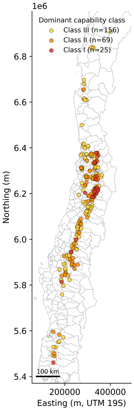
Figure 2.
Declared area of the elite-soil solar plants by region (plant count in parentheses).
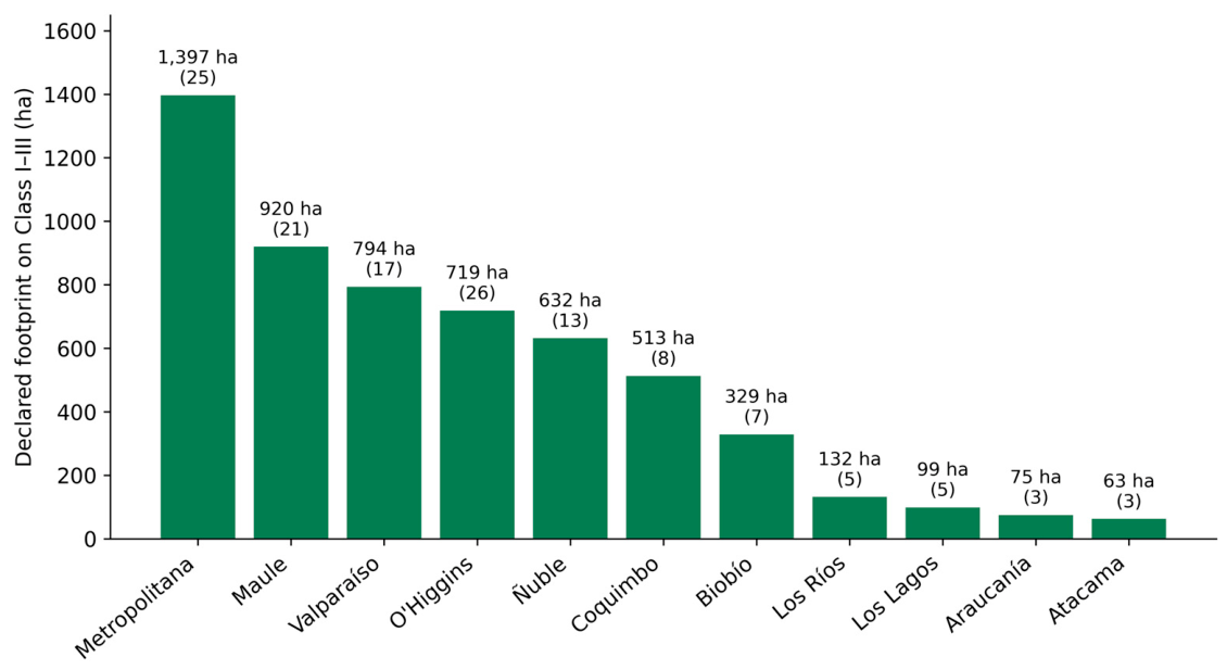
Figure 3.
On the left, the share of Class I–III soil in the mapped landscape (18.2%) against the share of approved solar plants on Class I–III (42.8%). On the right, the share of plants on Class I–III by processing status; approval and non-approval are statistically indistinguishable, indicating that soil use-capability does not screen the outcome.
Figure 3.
On the left, the share of Class I–III soil in the mapped landscape (18.2%) against the share of approved solar plants on Class I–III (42.8%). On the right, the share of plants on Class I–III by processing status; approval and non-approval are statistically indistinguishable, indicating that soil use-capability does not screen the outcome.
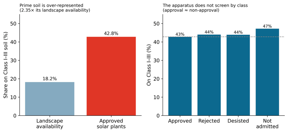
Figure 4.
Prior land cover of the solar-affected parcels (MapBiomas dominant class; n = 975 with cover). A majority were agriculture-pasture mosaic, indicating conversion of land in agricultural use rather than siting on merely capable ground.
Figure 4.
Prior land cover of the solar-affected parcels (MapBiomas dominant class; n = 975 with cover). A majority were agriculture-pasture mosaic, indicating conversion of land in agricultural use rather than siting on merely capable ground.
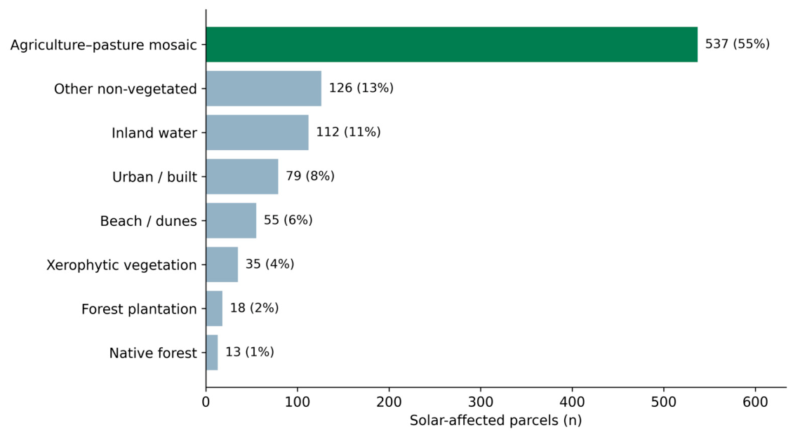
Figure 5.
Appraisal-market divergence in the contested sectors of Pirque and Rengo. Ratio of registered transaction price to fiscal appraisal, by commune and land use (market set, ratio ≥ 0.30; values capped at 18 times for display).
Figure 5.
Appraisal-market divergence in the contested sectors of Pirque and Rengo. Ratio of registered transaction price to fiscal appraisal, by commune and land use (market set, ratio ≥ 0.30; values capped at 18 times for display).
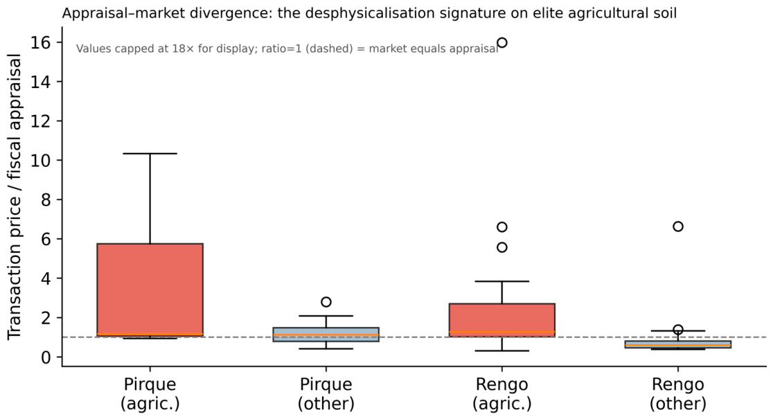

Table 1.
Permitting files coded in depth (n = 23) and the framing of soil in each.
| Project | Region | CIREN class | Area (ha) | Framing of soil |
| Barrancón | Metropolitan | I | 21.9 | Technical compensation |
| Purranque | Los Lagos | I | 18.1 | Technical compensation |
| Don Simón | O'Higgins | I | 14.3 | Technical compensation |
| El Capitán | Metropolitan | I | 13.6 | Technical compensation |
| Graneros | O'Higgins | I | 11.4 | Technical compensation |
| El Castaño | O'Higgins | I | 16.2 | Technical compensation |
| Ovejería | Metropolitan | I | 18.0 | Technical compensation |
| Chacabuco | Metropolitan | I | 30.1 | Technical compensation |
| Alameda | O'Higgins | I | 15.7 | Technical compensation |
| Malloa Solar | O'Higgins | I | 16.2 | Technical compensation |
| Don Darío | Metropolitan | II | 329.0 | Technical compensation |
| Chanqueahue (with BESS) | O'Higgins | VII* | 278.7 | Technical compensation |
| Polpaico Solar | Metropolitan | I | 28.0 | No mention |
| Coihue | Maule | I | 23.0 | No mention |
| Sol del Cobre | O'Higgins | I | 24.0 | No mention |
| Encon Solar | Valparaíso | I | 26.4 | No mention |
| Rengo Solar | O'Higgins | I | 25.0 | No mention |
| Alto Bellavista | O'Higgins | I | 18.6 | No mention |
| Santa Ines | O'Higgins | I | 15.1 | No mention |
| La Mocha Solar | Ñuble | III | 349.8 | No mention |
| Platero | Metropolitan | III | 11.4 | Agrivoltaic reframing |
| Ayla Solar | O'Higgins | I | 24.3 | Agrivoltaic reframing |
| Gran Teno | Maule | IV* | 381.7 | Denial of capability |
Note. The framing records how the Declaration or the Study characterises the soil of the property. Gran Teno (Class IV) and Chanqueahue (Class VII at the reference point of the CIREN layer, on agricultural soil in use according to the permitting file itself) are included as contrast cases; the remainder of the sample sits on Classes I–III.
Table 2.
Approved solar generation plants sited dominantly on Class I–III soil, by region.
| Region | Plants | Area (ha) |
| Metropolitana | 25 | 1,397 |
| Maule | 21 | 920 |
| Valparaíso | 17 | 794 |
| O'Higgins | 26 | 719 |
| Ñuble | 13 | 632 |
| Coquimbo | 8 | 513 |
| Biobío | 7 | 329 |
| Los Ríos | 5 | 132 |
| Los Lagos | 5 | 99 |
| Araucanía | 3 | 75 |
| Atacama | 3 | 63 |
| Total | 133 | 5,672 |
Disclaimer/Publisher’s Note: The statements, opinions and data contained in all publications are solely those of the individual author(s) and contributor(s) and not of MDPI and/or the editor(s). MDPI and/or the editor(s) disclaim responsibility for any injury to people or property resulting from any ideas, methods, instructions or products referred to in the content. |
© 2026 by the author. Licensee MDPI, Basel, Switzerland. This article is an open access article distributed under the terms and conditions of the Creative Commons Attribution (CC BY) license.
Copyright: This open access article is published under a Creative Commons CC BY 4.0 license, which permit the free download, distribution, and reuse, provided that the author and preprint are cited in any reuse.