
Submitted:
22 July 2026
Posted:
23 July 2026
You are already at the latest version
Abstract
Digital survey and three-dimensional modelling have become central tools for the documentation and interpretation of architectural heritage, yet their epistemic role in the study of early Christian architecture still requires critical assessment. This article examines three early Christian sacella in northern Italy—Sante Teuteria e Tosca in Verona, Santa Maria Mater Domini in Vicenza, and San Prosdocimo in Padua—in order to evaluate how digital models can support architectural analysis without replacing direct engagement with the material monument. The study combines terrestrial laser scanning, photographic documentation, point-cloud processing, orthophotos, and architectural drawings to investigate masonry evidence, spatial organisation, roofing traces, and volumetric relationships. The results show that digital models make it possible to compare architectural elements that are difficult to observe simultaneously on site, especially in relation to construction sequences, domed spaces, subsidiary vaulted compartments, and traces of earlier phases. At the same time, the analysis demonstrates that digital visibility remains partial, since material presence, light, scale, and bodily experience cannot be fully reproduced in a virtual environment. The article argues that digital models are most valuable when understood as interpretative mediators: tools that extend observation, support comparison, and encourage renewed attention to the architectural fabric itself.
Keywords:
early Christian architecture
; sacella
; digital heritage
; three-dimensional modelling
; digital survey
; point-cloud data
; architectural interpretation
; material heritage
; GIS
; public interaction
1. Introduction
Over the last two decades, digital technologies have progressively transformed the ways in which architectural heritage is recorded, analysed, and presented [1,2,3]. Photogrammetric survey, laser scanning, three-dimensional modelling and spatial analysis are now widely employed not only to document historic buildings with increasing accuracy, but also to investigate aspects of their construction and spatial organisation that are not always immediately perceptible through direct observation alone [1,2]. At the same time, however, the growing reliance on digital environments has raised a series of methodological questions which remain only partially explored, particularly within the field of architectural history [4,5]. If such tools undoubtedly extend the possibilities of access and analysis, they also mediate the encounter with the monument in specific and sometimes problematic ways [4,5,6]. This is especially true in the study of historic architecture, where interpretation still depends to a large extent on the close reading of material fabric, building techniques, and the physical experience of space. In this respect, digital models should perhaps be understood not simply as neutral reproductions of architectural reality, but rather as interpretative instruments that inevitably influence the ways in which buildings are perceived, observed, and understood [3,5,6].
The study of early Christian architecture often confronts the historian with a practical difficulty: much of what matters architecturally is not always immediately visible [7,8]. Buildings of the fifth and sixth centuries have frequently been altered over time, sometimes extensively, and their present appearance only rarely corresponds entirely to their original configuration [7]. Yet even where preservation is relatively good, interpretation still depends upon the careful reading of details that may easily escape notice during direct observation alone [8,9]. Slight changes in masonry, interruptions in building technique, traces of later intervention, or small inconsistencies in spatial articulation can all prove significant for understanding how a structure was conceived and transformed [8,9]. The three sacella examined here offer a particularly interesting case in this respect. Small in scale and comparatively well preserved, they allow close architectural analysis while at the same time presenting a degree of complexity not always evident at first sight. It is precisely under such circumstances that digital models may prove useful, not as substitutes for the monument, but as instruments through which observation itself can be prolonged, repeated, and occasionally re-evaluated [1,2,3,10].
At the same time, the growing use of digital technologies in heritage studies calls for a degree of caution [4,5]. The increasing availability of highly detailed three-dimensional models, sometimes described in broader heritage discourse as digital twins, can easily create the impression that architectural knowledge has become more immediate simply because a building is digitally accessible [4,5,6]. The situation is, however, somewhat less straightforward. Even a highly accurate model does not reproduce a building in neutral or exhaustive terms [3,4,5,11]. Some features inevitably become clearer, while others may lose part of the material context that gives them meaning when observed directly. The possibility of enlarging details, isolating specific elements, or reconsidering spatial relationships from different viewpoints can undoubtedly support analysis, yet interpretation still depends upon questions that the model itself cannot answer [3,5,12]. This is particularly relevant in the study of historic architecture, where understanding often emerges gradually through repeated observation and comparison, and sometimes through elements that appear secondary at first sight: an irregular masonry joint, a change in constructional rhythm, or a slight inconsistency in spatial arrangement. For this reason, the usefulness of digital tools may ultimately depend less on technological sophistication than on the ways in which they encourage a closer and more sustained engagement with the monument [3,5,12].
The present study focuses on three small sacella located in northern Italy: the chapel of Sante Teuteria and Tosca in Verona, Santa Maria Mater Domini in Vicenza, and San Prosdocimo in Padua. Built between the fifth and sixth centuries, the three monuments can be considered a fairly coherent group, both in chronological terms and in relation to their architectural character [13]. At the same time, however, they have rarely been examined together, despite a number of evident similarities. Their condition of preservation also deserves particular attention. Although each sacellum has undergone its own transformations over time, all still preserve significant portions of the early fabric [7,8,13]. This makes it possible to observe masonry techniques, constructional choices, and aspects of spatial organisation that are often far more difficult to identify in buildings surviving only fragmentarily [8,9]. For this reason, the three sacella provide an especially useful context in which to reflect upon the contribution that digital survey and modelling may offer to architectural interpretation [1,2,3,10,12]. Their relatively small scale permits close and repeated examination, while their good quality of preservation enables a more careful assessment of the relationship between digital representation and material evidence [3,5,12].
Within this context, the following study considers how digital survey and three-dimensional modelling may enhance the interpretation of early Christian architecture, taking the three sacella examined here as a closely related group of case studies [1,2,3,10]. Particular attention is paid not only to what such technologies make visible, but also to the ways in which digital representations may shape architectural understanding [3,4,5,11,12]. The point, however, is not merely whether digital models improve access to historic buildings. A more difficult question concerns the ways in which they may influence interpretation itself, particularly in relation to monuments whose material fabric still remains central to architectural understanding [3,4,5,11]. Starting from the case of the three sacella, the following discussion reflects on the possibilities opened up by digital survey, but also on some of the questions it inevitably raises [1,2,10,12]. Certain aspects of a building may become easier to examine, while others still resist interpretation or require repeated comparison with the monument itself [8,12]. For this reason, the usefulness of digital models may depend less on the technology itself than on the kinds of observation and analysis that they make possible [3,5,12].
2. Materials and Methods
2.1. Case Studies: The Three Early Christian Sacella of Padua, Vicenza, and Verona
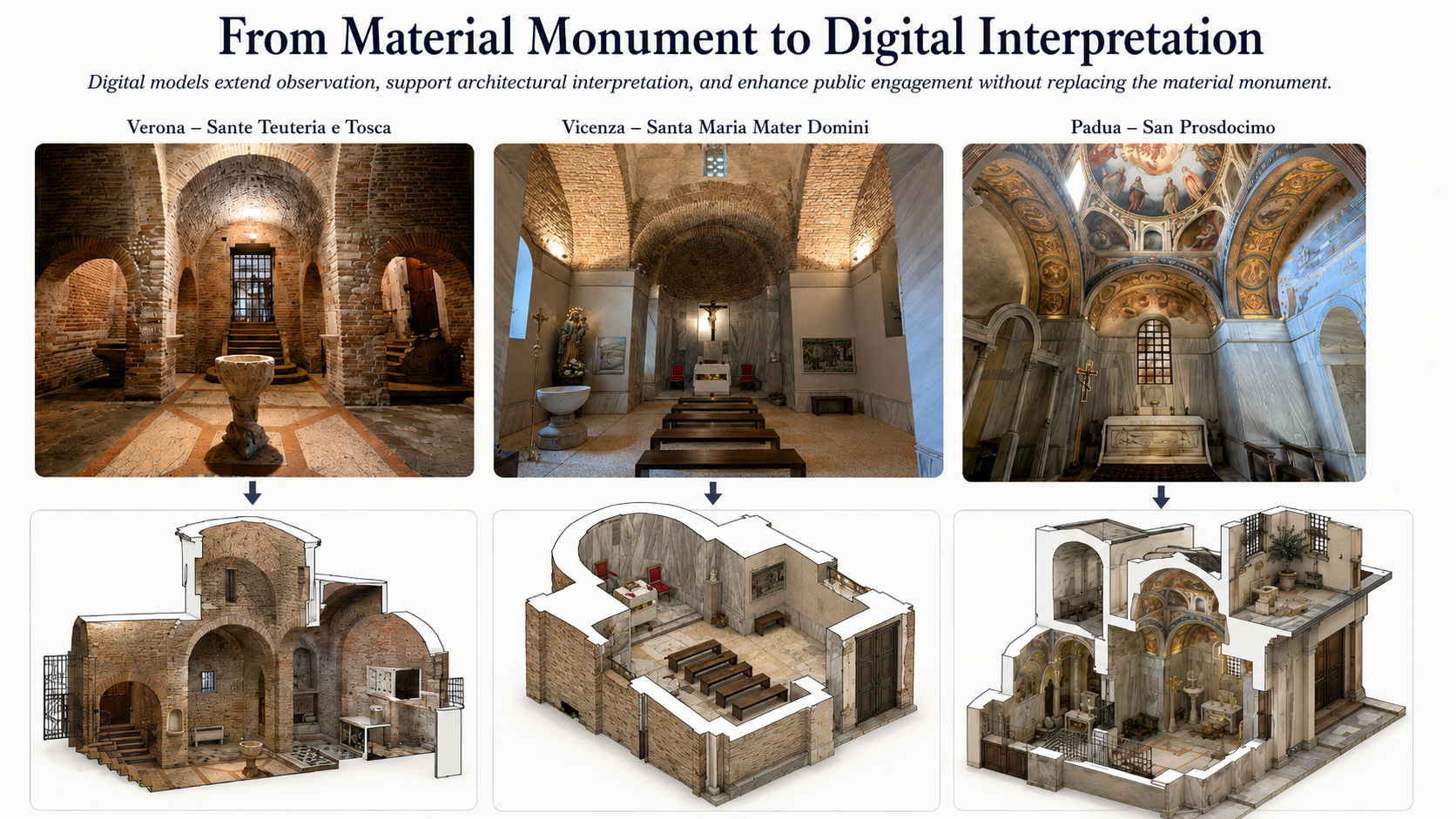
The three monuments examined in this article constitute the material basis of the investigation. They were selected not only for their historical and architectural relevance, but also because their scale, state of preservation, and surviving constructional evidence allow the relationship between digital documentation and architectural interpretation to be assessed in concrete terms. The following section therefore presents the three sacella as case studies before turning to the survey and modelling procedures adopted for their analysis. The three monuments are introduced visually in Figure 1, which provides a preliminary view of their material and spatial character.
2.1.1. A Coherent Architectural Group
The three sacella considered in this study were all erected between the fifth and sixth centuries within a relatively limited geographical area of northern Italy, between Verona, Vicenza, and Padua. Despite evident differences in decoration, construction, and later history, they share a number of architectural characteristics that justify their consideration as a coherent group. All three are associated with important ecclesiastical complexes and with spaces connected to burial, memoria, and the cult of saints. Their plans are centrally organised and reveal a clear interest in the spatial and symbolic emphasis placed upon relics and privileged liturgical areas, in ways that find close parallels in Ravenna and, more generally, within the architectural culture of the upper Adriatic during late antiquity. Yet the relationship with Ravenna should probably not be understood too rigidly. These buildings do not simply reproduce a single architectural model. In each case, common forms and constructive solutions appear to have been adapted to specific local conditions and functions [14]. This aspect is particularly important because it allows the three sacella to be approached not only as isolated monuments, but also as evidence of broader processes of architectural transmission and reinterpretation. Their state of preservation further increases their importance. Although altered over time, all three structures still retain substantial portions of the original fabric, making possible a type of detailed architectural examination that is often much more difficult in heavily transformed buildings.
2.1.2. Architectural Relationships and Regional Context
The strongest points of contact between the three sacella emerge above all in their spatial organisation and in the architectural language employed to define areas associated with memoria and the cult of saints. San Prosdocimo in Padua, generally dated to the first decades of the sixth century through the inscription mentioning the patricius Opilione, and Santa Maria Mater Domini in Vicenza, probably constructed shortly afterwards during the early sixth century, both adopt an inscribed Greek cross plan covered by a central dome resting on pendentives, combined with barrel-vaulted arms and preceded by a narthex connected to the adjoining basilical complex [15]. In both cases, the relationship with Ravenna appears particularly evident, not only in the use of centrally organised spaces and domed structures, but also in the articulation of liturgical furnishings, wall revetments, mosaics, and sculptural elements closely associated with the architectural culture of the upper Adriatic during the Ostrogothic and early Byzantine periods [16]. The sacellum of Sante Teuteria and Tosca in Verona presents a rather different situation. Although traditionally compared with the monuments of Padua and Vicenza, its architectural configuration appears substantially distinct. Recent analysis suggests that the building was probably erected between the middle of the fifth century and the beginning of the sixth, originally adopting a free Greek cross plan rather than an inscribed one, with vaults resting directly upon the perimeter walls and with a more pronounced volumetric emphasis on the central lantern. Seen from this perspective, the comparison with the Mausoleum of Galla Placidia in Ravenna acquires a particular importance. The similarities are not limited to the general form of the building, but also concern the broader cultural environment in which these architectural solutions circulated across the northern Adriatic during late antiquity. Even the original dedication of the Veronese sacellum to Saint Apollinaris—the protomartyr and patron saint of Ravenna—seems unlikely to be accidental and probably reflects a conscious connection with the religious and cultural prestige of the Ravenna church [17]. At the same time, the three sacella still preserve marked differences. Their plans, constructional choices, decorative programmes, and relationships with the adjoining ecclesiastical complexes vary considerably from one case to another. Rather than suggesting the simple repetition of a single model, these buildings appear to document the adaptation of shared architectural ideas to different local situations and devotional needs. It is precisely this combination of similarities and differences that makes the three sacella particularly valuable for understanding the architectural culture of northern Italy between late antiquity and the early Middle Ages.
2.1.3. Towards a Digital Reassessment
The architectural characteristics of the three sacella also help to explain why digital survey and three-dimensional modelling can contribute meaningfully to their study. Although modest in scale, these buildings are often difficult to interpret through direct observation alone. In many cases, understanding the original organisation of the spaces depends upon details that are not immediately evident during a visit: slight irregularities in the masonry, interruptions in the constructional rhythm, traces of blocked openings, or subtle changes in the relationship between walls and vaults. Reading these elements usually requires prolonged observation and repeated comparison between different parts of the structure. This is particularly evident in the sacellum of Sante Teuteria and Tosca, where the reconstruction of the original volumetric arrangement relies heavily upon architectural traces still preserved within the masonry [18].
Under these conditions, digital models become useful not simply because they provide accurate representations of the monuments, but because they enable certain architectural relationships to be reconsidered more carefully over time. Details that are difficult to compare during a site visit can be re-examined repeatedly, while spatial connections between different parts of the building become easier to observe from alternative viewpoints. At the same time, however, the model does not eliminate interpretative uncertainty. On the contrary, it often makes problematic aspects of the architecture more apparent and encourages further questions concerning chronology, constructional development, and the relationship between the different phases of the buildings. For this reason, the digital survey is most effective not when treated as a substitute for direct engagement with the monument, but when used as a means of supporting a slower and more sustained form of architectural observation [19,20].
2.2. Digital Survey and Modelling Methodology
The methodological framework combined digital acquisition, metric control, image-based documentation, and architectural redrawing. These operations were not treated as separate technical procedures, but as successive stages of a single interpretative process. The aim was to move from the documentation of geometry and surface data to the production of drawings, orthophotos, and models capable of supporting historical and architectural analysis.
2.2.1. Survey Design and Documentary Aims
The digital survey of the three sacella was conceived not simply as a process of metric acquisition, but as the construction of a reliable documentary basis for architectural analysis. In the field of architectural heritage, integrated survey procedures have increasingly shown their value not only for recording geometry, but also for organising information useful for conservation, interpretation, and representation [21,22,23,24]. In this perspective, the survey was designed as a knowledge-oriented process, capable of producing metric data, visual documentation, and graphic outputs suitable for the historical and architectural study of the monuments.
The fieldwork was carried out in different phases, according to the accessibility, lighting conditions, and spatial configuration of each building. Although the sacella are relatively small and their geometries are not particularly complex in themselves, their position within larger and stratified religious complexes required careful planning. Later additions, adjoining spaces, and discontinuous connections between interiors and exteriors made it necessary to consider each sacellum not as an isolated object, but as part of a more complex architectural system.
For this reason, the survey aimed to document both the internal spaces and their relationship with the surrounding built fabric. The objective was not limited to the production of a geometrically accurate record of the monuments. More importantly, the survey sought to provide a basis for the study of their constructional history, spatial organisation, and material evidence. The level of detail was therefore planned in relation to architectural representation at least at the scale of 1:50, with particular attention to walls, vaults, openings, masonry discontinuities, construction joints, and surface traces potentially relevant to the historical and archaeological interpretation of the buildings [21,22,23].
2.2.2. Integrated Data Acquisition
The acquisition strategy combined range-based and image-based techniques. Terrestrial laser scanning was used to produce dense and geometrically consistent point clouds of the architectural spaces, while photographic acquisition supported the generation of textured models, orthophotos, and high-resolution photoplans. The integration of laser scanning and photogrammetric procedures has proved particularly effective in the documentation of historic buildings, especially when the survey is intended to support not only representation, but also the analysis of constructive, material, and structural evidence [22,23,24].
The range-based survey was carried out using a Leica RTC360 terrestrial laser scanner, while the photographic documentation was acquired with a Sony Alpha 7R V camera. From an operational point of view, the survey of the interiors was relatively manageable because of the limited size of the sacella and the general simplicity of their wall surfaces. The main challenges were connected instead with the articulation of the spaces, the presence of vaulted structures, and the need to relate the interior of each sacellum to its exterior or surrounding architectural context. Since these connections were not always direct, the scanning paths had to be extended beyond the immediate limits of the monuments. Additional scan positions were therefore planned in order to create a continuous sequence of stations capable of linking the inner and outer areas.
The photographic survey required particular attention to lighting conditions. The small dimensions of the interiors, the presence of curved and vaulted surfaces, and the contrast between illuminated and shadowed areas made exposure control especially important. The acquisition was therefore planned in order to avoid excessive overexposure in the brightest areas and loss of information in darker portions of the surfaces. This was particularly relevant for the production of photogrammetric models and orthophotos, where the quality of the photographic dataset directly affects the readability of textures, masonry patterns, and surface discontinuities.
2.2.3. Data Processing and Metric Control
The laser scanner data were processed through a registration workflow based mainly on cloud-to-cloud alignment. This procedure was especially important where the relationship between internal and external spaces was indirect or fragmented. The extended acquisition paths made it possible to build a stable sequence of connections between different scan positions and to control the accumulation of registration errors. In this sense, the survey strategy was not only a matter of covering the visible surfaces, but also of constructing a coherent metric framework within which the different parts of each monument could be spatially related.
The resulting point clouds provided the primary geometric basis for the subsequent phases of documentation and representation. Their density made it possible to analyse architectural surfaces with a high level of precision, especially in relation to wall profiles, vault geometries, openings, and irregularities in the built fabric. At the same time, the image-based datasets were processed through Structure from Motion workflows in order to generate three-dimensional models derived from the photographic acquisition. These models were then triangulated and textured, producing high-resolution orthophotos and photoplans useful for the study of surface materials and constructional details.
The integration between laser scanner data and photographic outputs was therefore essential. The point cloud provided metric reliability and spatial consistency, while the photographic models and orthophotos offered visual information related to material texture, colour variation, masonry articulation, and surface traces. Neither dataset was treated as autonomous. The methodological value of the survey depended instead on the possibility of comparing and integrating different forms of information: geometric, visual, material, and interpretative. Recent research on built heritage documentation has emphasised precisely this passage from raw acquisition to structured and semantically meaningful forms of representation [25,26,27].
2.2.4. From Point Cloud to Architectural Drawing
A central aspect of the methodology concerned the transition from the three-dimensional point cloud to two-dimensional architectural representation. This passage was understood as a critical operation rather than as the automatic extraction of lines from digital data. The point cloud was not considered the final result of the survey, but the metric and spatial framework from which plans, sections, elevations, and detailed drawings could be produced. The cognitive value of this operation lies in the fact that survey drawing is never a neutral transcription of data, but the result of a process of selection, interpretation, and graphic synthesis [26,27,28].
The process of redrawing required continuous comparison between different sources of information. The geometric data extracted from the point cloud were checked against photographic documentation, orthophotos, textured models, and observations made directly on site. This was particularly important because the architectural features relevant to the interpretation of the sacella are not always reducible to simple geometric profiles. Wall irregularities, slight changes in masonry texture, discontinuities between construction phases, traces of blocked openings, and variations in the relationship between walls and vaults all required a selective and interpretative reading.
For this reason, the drawings were produced through a process of controlled redrawing. The density of the point cloud made it possible to measure and locate architectural evidence with precision, but its translation into graphic form required decisions concerning hierarchy, legibility, and analytical emphasis. Not every point contained in the cloud could, or should, be translated into a line. The task of the drawing was instead to organise the complexity of the digital data into a readable architectural document capable of supporting historical and archaeological analysis. In this perspective, the passage from survey data to drawing formed part of the analytical process itself, as suggested by studies addressing the transition from digital documentation to interpretative modelling, semantic organisation, and reconstruction [5,27,28,29].
Particular attention was paid to the representation of structural profiles, wall thicknesses, vault geometries, openings, floor levels, construction joints, and surface discontinuities. These elements were not drawn only as formal components of the buildings, but also as potential evidence for understanding their constructional development and later transformations. The drawings therefore aimed to preserve the metric accuracy of the survey while making the architectural relationships intelligible. Since the drawings were intended to be suitable at least for representation at 1:50, the restitution process had to balance precision and readability. Excessive simplification would have reduced their analytical value, while excessive graphic density would have made them difficult to interpret.
2.2.5. Graphic Restitution as an Analytical Tool
The graphic restitution was conceived as an analytical tool rather than as a neutral transcription of measured data. In monuments such as the three sacella, architectural interpretation often depends on elements that are small, discontinuous, or difficult to compare during direct observation alone. Plans, sections, elevations, orthophotos, and photoplans made it possible to bring these elements together within a single representational framework, allowing the comparison of wall surfaces, vaulted structures, openings, and material traces that are not always visible simultaneously on site.
The value of the digital survey therefore lay not only in the precision of the acquisition instruments, but also in the way the acquired data were processed, selected, and translated into architectural representation. The point cloud preserved a dense and continuous record of the monument, but the drawing transformed this density into a structured document. Through this process, representation became capable of supporting a slower and more critical study of the buildings. The role of the drawing was therefore not secondary to the digital model; rather, it constituted the interpretative moment in which metric data, visual evidence, and architectural questions were brought into relation [5,27,28].
This approach was particularly important because the three sacella require close architectural reading. Their small dimensions can give the impression of immediate intelligibility, yet many aspects of their historical significance emerge only through careful observation of details: the articulation of the vaults, the relationship between interior and exterior volumes, the discontinuities in the masonry, and the traces connected with earlier phases of construction. The digital survey and the subsequent graphic restitution were therefore designed to make these relationships more accessible to analysis.
In this sense, the methodology adopted for the three sacella confirms that digital documentation is most useful when it does not remain confined to the production of models or point clouds. Its value emerges when digital data are transformed into instruments of interpretation. The final drawings, orthophotos, and models were not simply documentary outputs, but devices through which architectural evidence could be observed, compared, and reconsidered. The quality of the representation was therefore inseparable from the quality of the historical and architectural questions that the survey was intended to support [5,30].
3. Results
3.1. Seeing the Invisible: Digital Models as Epistemic Devices
The methodology described above provided the documentary and graphic basis for a more detailed architectural reading of the three sacella. Once survey data had been processed, compared, and translated into drawings, orthophotos, and three-dimensional models, certain relationships between walls, vaults, openings, and volumetric structures became easier to examine together. Details that initially appeared secondary acquired greater interpretative significance when repeatedly considered within the digital environment and compared with the evidence observed directly on site. In several cases, the models also made it possible to reconsider problems that are difficult to address through direct observation alone, particularly where the surviving fabric preserves only fragmentary traces of earlier architectural phases. The usefulness of the digital model therefore lies not merely in its descriptive precision, but in its capacity to support forms of analysis that gradually transform observation into interpretation [18]. It is in this sense that the models may be understood as epistemic devices: not autonomous substitutes for the monument, but instruments through which architectural knowledge can be extended, tested, and occasionally reformulated.
3.2. Reading Masonry and Construction Sequences
The contribution offered by digital survey becomes particularly evident when the architectural analysis depends upon elements that are fragmentary, partially concealed, or difficult to compare directly during a site visit. In the case of the three sacella examined here, many aspects of the buildings can only be understood through the careful correlation of details dispersed across different parts of the structure: interruptions in the masonry, traces of former roofing systems, slight irregularities in the walls, or discontinuities between adjoining constructional elements. Individually, such features may appear secondary. Considered together, however, they often provide important indications concerning the original configuration of the buildings and their subsequent transformations [31].
This aspect emerges especially clearly in the sacellum of Sante Teuteria and Tosca in Verona. The present appearance of the building does not entirely preserve its early medieval volumetric organisation, which can only be reconstructed through the interpretation of surviving architectural traces embedded within the masonry. In particular, the reading of the upper wall sections and the surviving evidence connected with the roofing system made it possible to recognise the probable articulation of the original Greek-cross plan and the differing heights of the lateral arms [18]. Certain traces associated with the lines of the former roofs become far easier to compare within the three-dimensional survey environment. Elevations, wall surfaces, and volumetric relationships can be examined simultaneously rather than separately. The model therefore assists interpretation not by replacing direct observation, but by allowing architectural evidence distributed across different parts of the monument to be reconsidered within a more coherent spatial framework, as illustrated by the survey outputs presented in Figure 2 [32].
A similar situation may also be observed in the sacella of Padua and Vicenza, where the relationship between the central domed spaces, the subsidiary vaulted compartments, and the surrounding masonry structures is not always immediately legible from ground level alone [15]. Here again, the digital models make possible repeated comparison between structural elements that are difficult to analyse simultaneously during direct inspection. In some cases, dimensional irregularities or minor asymmetries become more apparent only through the repeated examination of plans, sections, and volumetric reconstructions derived from the survey data [33]. Such observations are important not because they provide definitive answers concerning chronology or construction, but because they reveal aspects of the buildings that might otherwise remain difficult to perceive with equal clarity.
3.3. Reconstructing Spatial and Volumetric Relationships
The contribution of digital modelling becomes equally significant when the analysis concerns broader spatial and volumetric relationships within the buildings. In monuments such as the sacella of San Prosdocimo in Padua and Santa Maria Mater Domini in Vicenza, architectural understanding depends not only upon individual structural elements, but also upon the way in which centralised spaces, subsidiary volumes, and roofing systems interact to produce a coherent spatial organisation [13]. Direct observation alone often makes it difficult to perceive these relationships simultaneously, particularly within relatively small interiors where the articulation of the upper structures remains only partially visible from ground level [34,35].
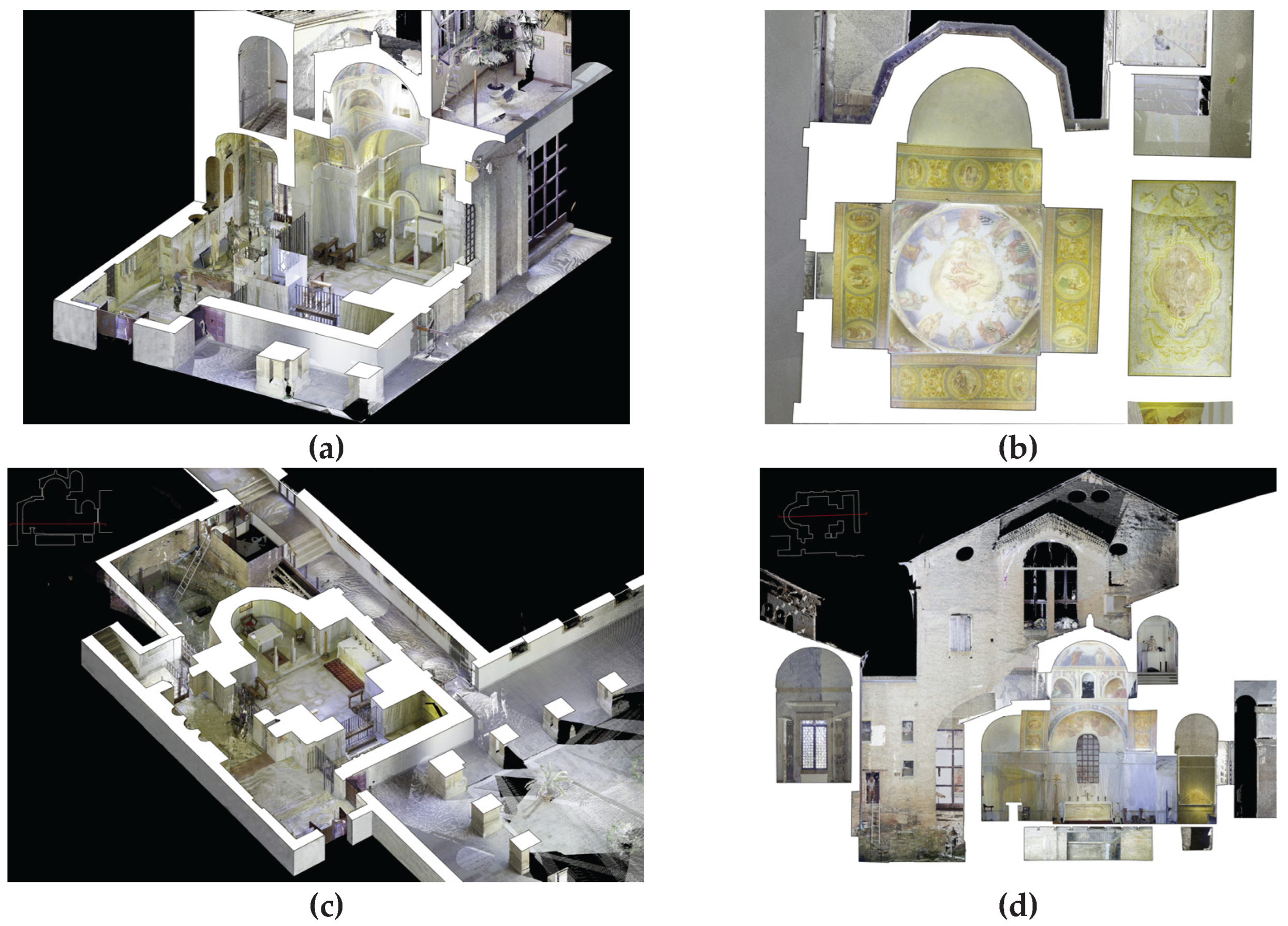
The three-dimensional models make it possible to reconsider these spatial connections within a unified visual framework. In both Padua and Vicenza, the relationship between the domed central compartment and the barrel-vaulted lateral arms becomes easier to compare through sections, axonometric reconstructions, and volumetric analysis derived from the survey data [32,36]. Certain architectural correspondences between the two buildings—including the use of four angular supports carrying the central dome, the articulation of the subsidiary spaces, and the external organisation of the roofing systems—emerge with greater clarity once the structures can be examined comparatively and from multiple viewpoints. At the same time, the models also reveal differences that are more difficult to appreciate through isolated observation alone, particularly in the proportions of the lateral spaces, the relationship between the dome and the surrounding walls, and the varying treatment of the eastern sectors connected with the liturgical areas, as illustrated by the survey outputs for Santa Maria Mater Domini and San Prosdocimo presented in Figure 3 and Figure 4.
Similar considerations apply to the relationship between these buildings and the broader architectural culture of the northern Adriatic during late antiquity. Comparisons with monuments such as the chapel of Sant’Andrea in Ravenna or the lost sacella of Rimini and Este have traditionally relied upon plans, written descriptions, and partial reconstructions. Digital modelling does not eliminate the interpretative uncertainties surrounding these comparisons, especially in the case of partially preserved or heavily transformed monuments. It does, however, make possible a more controlled comparison between surviving spatial structures, proportions, and volumetric systems [14]. In this sense, the model becomes less a static representation of the monument than a tool through which architectural relationships can be tested, reconsidered, and observed under changing analytical conditions.
3.4. Repeatable Observation and Comparative Analysis
One of the most significant aspects of the digital survey concerns the possibility of returning repeatedly to the architectural evidence after the conclusion of the site investigation itself. Direct observation of historic buildings is inevitably conditioned by practical limitations: access, lighting conditions, restricted viewpoints, and the difficulty of comparing distant portions of the structure simultaneously. In buildings such as the three sacella examined here, where many architectural relationships depend upon details distributed across different levels and spatial sectors, prolonged comparison often becomes difficult to sustain entirely through autoptic inspection alone [31,33].
The digital models partially modify these conditions of observation. Once integrated within the three-dimensional survey environment, architectural elements can be re-examined over time, isolated from surrounding structures, or compared from viewpoints that are difficult to obtain during direct inspection of the monument. Sections, volumetric reconstructions, and high-resolution wall surfaces make it possible to reconsider relationships between structural components that might otherwise remain only partially perceptible [37,38,39]. In the case of the Veronese sacellum, for example, the repeated examination of the upper masonry and roofing traces made it possible to verify certain hypotheses concerning the articulation of the original cross-shaped structure. Similar processes of comparison also proved important in relation to the sacella of Padua and Vicenza, particularly in analysing the proportional relationships between the centralised spaces and the subsidiary vaulted compartments.
At the same time, however, the repeated accessibility of the digital model should not be confused with interpretative completeness. The model preserves and reorganises visual information, but architectural understanding still depends upon the selection, correlation, and interpretation of the evidence itself [11]. Certain ambiguities remain unresolved, while other aspects of the buildings acquire significance only gradually through continued comparison between the digital reconstruction and the material monument. Precisely for this reason, the value of the model lies less in the production of a definitive representation than in its capacity to support an open and repeatable process of architectural observation.
4. Discussion
4.1. Beyond Technological Enthusiasm: The Primacy of Material Heritage
The growing sophistication of digital survey technologies has profoundly expanded the possibilities available for the study and visualisation of architectural heritage. Only a few decades ago, many forms of observation that are now relatively common — detailed volumetric comparison, the repeated examination of inaccessible structures, or the close inspection of fragile architectural surfaces — would have been far more difficult to sustain over time. Digital models have undoubtedly changed the practical conditions under which historic buildings can be documented and analysed [36,37]. At the same time, however, this increasing precision can also encourage a certain misunderstanding. The more coherent and visually persuasive the reconstruction becomes, the easier it may be to forget that architectural interpretation still depends upon the physical monument and not upon its digital counterpart alone.
This aspect becomes particularly evident in the case of early Christian architecture. Much of what defines these buildings cannot always be reduced entirely to geometry or measurable form. Slight irregularities in the masonry, changes in the behaviour of light across surfaces, variations in scale perceived while moving through confined interiors, or the relationship between liturgical orientation and bodily movement within space all contribute to the architectural experience of the monument. Such qualities are difficult to isolate completely within a digital environment because they emerge gradually through direct engagement with the building itself. This aspect becomes particularly evident in the three sacella examined here. Their relatively small dimensions encourage close observation, yet many of the architectural relationships that define their character emerge only through prolonged engagement with the buildings themselves, whether in the articulation of the vaulted spaces, the behaviour of light within the interiors, or the reading of the surviving masonry. For this reason, even the most accurate model cannot fully coincide with the material reality of the monument from which it derives [40].
4.1.1. The Limits of Digital Visibility
Digital models undoubtedly increase the volume of visual information available to the observer. Architectural surfaces can be magnified, measured, isolated, and re-examined with a level of continuity that is often impossible during direct inspection of the monument itself. Yet increased visibility does not necessarily coincide with complete architectural intelligibility. Certain aspects of historic buildings become clearer within the digital environment, while others remain resistant to full visual translation or lose part of the contextual conditions through which they acquire meaning [11,32].
This limitation becomes particularly evident in relation to material surfaces. High-resolution survey techniques are capable of reproducing geometry with extraordinary precision, but the appearance of masonry under changing light conditions, the tactile perception of irregular wall textures, or the gradual transition between restored and original surfaces often remain more difficult to perceive through the model alone. Similar difficulties also emerge in relation to scale. Within relatively small buildings such as the three sacella examined here, spatial perception depends not only upon measurable dimensions, but also upon bodily movement, restricted viewpoints, changing proximity between architectural elements, and the gradual adaptation of vision within confined interiors [40,41,42]. Such conditions remain largely irreproducible within a digital reconstruction, regardless of the model’s accuracy.
For this reason, the digital survey should perhaps be understood less as a complete visual substitute for the monument than as a selective extension of architectural visibility. The model may reveal relationships that are difficult to perceive directly, yet at the same time it inevitably reorganises the conditions under which the building is observed. Certain details become more prominent, while others recede into the background or lose part of their material ambiguity. In this sense, digital visibility always remains partial: not because the model fails technically, but because architectural experience itself cannot be reduced entirely to visual data alone.
4.1.2. Material Presence and Architectural Experience
The limits of digital visibility become even more apparent when architectural understanding relies on direct spatial experience. Historic buildings are not perceived exclusively through detached visual observation. They are encountered through movement, changing proximity, variations in light, and the gradual adjustment of the body within space. This aspect becomes especially important in relatively small structures such as the three sacella examined here, where the relationship between the observer and the architectural fabric is unusually immediate. Walls, vaults, openings, and liturgical focal points are perceived at close range and often simultaneously, producing spatial impressions that depend as much upon physical presence as upon measurable form [40,41].
In buildings of this kind, the architectural experience often emerges through subtle conditions that are difficult to isolate analytically. Slight asymmetries in the organisation of the spaces, the changing behaviour of natural light across curved masonry surfaces, or the compressed relationship between the central domed compartments and the subsidiary vaulted sectors all contribute to the perception of the monument as a material environment rather than as an abstract geometric structure. In the three sacella, these conditions become visible in different ways. At Padua and Vicenza, they emerge in the relationship between the central domed spaces and the subsidiary vaulted compartments, while in Verona they are reflected in the articulation of the cross-shaped arrangement and in the surviving traces associated with the original roofing system. Such qualities can certainly be documented in part through digital survey, yet they are not entirely transferable into the virtual model itself [42,43]. The experience of scale, proximity, and movement within the building remains tied to the physical encounter with the monument and to the temporal conditions under which that encounter unfolds.
For this reason, the material monument retains an interpretative authority that a digital reconstruction cannot completely absorb. The model may extend observation and facilitate comparison, but it does not replace the physical complexity of the architectural object from which its data derive. Indeed, the closer a digital reconstruction approaches geometric precision, the more evident the irreducibility of certain material and spatial aspects of the monument may sometimes become. In this respect, the value of digital technologies perhaps lies not in overcoming the limitations of direct observation, but rather in encouraging a more attentive return to the building itself.
4.1.3. Digital Models as Interpretative Mediators
The observations developed so far suggest that digital models are perhaps most useful not when they are treated as complete substitutes for the monument, but when they are understood as instruments capable of modifying the conditions under which architectural observation takes place [11,32]. In the case of the three sacella examined here, the models made certain forms of comparison considerably easier to sustain over time. Relationships between vaults, wall surfaces, roofing structures, and subsidiary spaces could be reconsidered repeatedly and from viewpoints that are often difficult to maintain during direct inspection alone. At the same time, however, the process of interpretation continued to depend less upon the model itself than upon the ways in which the architectural evidence was selected, correlated, and gradually understood.
This aspect becomes particularly evident whenever the buildings preserve traces belonging to different historical phases. In structures such as the sacella of Verona, Padua, and Vicenza, many architectural elements cannot be interpreted in isolation. Slight discontinuities in the masonry, irregular transitions between adjoining surfaces, or uncertainties connected with the roofing systems acquire significance only when examined in relation to broader spatial and constructional relationships. The digital environment can undoubtedly assist this process by making repeated observation easier and by allowing different parts of the monument to be compared more carefully. Yet the model does not eliminate ambiguity. Certain aspects remain uncertain, while others continue to require direct comparison with the material structure of the building itself [31,33].
For this reason, the value of digital reconstruction may ultimately depend less upon the production of increasingly complete virtual representations than upon its ability to support a slower and more attentive form of architectural analysis. The model reorganises visual information, but it does not determine interpretation automatically [39]. Rather, it creates a space within which architectural questions can be reformulated, verified, and occasionally reconsidered through continued engagement with the monument. In this respect, digital technologies become most useful not when they attempt to replace autoptic observation, but when they encourage a more sustained return to the architectural object itself.
4.2. Reimagining Access: Public Interaction and the Question of “Play”
The discussion of digital models also concerns the ways in which architectural heritage may be approached by non-specialist audiences. In the case of the three sacella, public interaction is not understood primarily in terms of entertainment or visual immersion, but as an opportunity to encourage more attentive forms of observation. Digital access, when carefully framed, can help users return to architectural details, spatial relationships, and material traces that may otherwise remain only partially perceived.
4.2.1. From Passive Viewing to Exploratory Engagement
This broader dimension is especially relevant where direct access to architectural heritage remains conditioned by practical circumstances, including opening hours, conservation requirements, or the limited time available during a visit. In many cases, direct access to architectural heritage remains conditioned by practical circumstances, including opening hours, conservation requirements, or the limited time available during a visit. The three sacella examined in this study are no exception. Although all three monuments remain accessible, many of the architectural relationships that contribute to their historical significance are not immediately apparent during a brief encounter with the buildings themselves [44,45].
Digital models offer an additional opportunity for observation. Elements that may receive only limited attention during a visit can be revisited afterwards and examined within a broader architectural context. The organisation of the vaulting systems, the relationship between the centralised spaces and the subsidiary compartments, or the traces associated with earlier construction phases can all be explored repeatedly and from viewpoints that are not always available on site. In this respect, the model does not simply provide additional information. It creates a different rhythm of observation, allowing visitors to return to particular features of the monument and to compare them more carefully over time.
This possibility may prove especially valuable in the case of relatively small buildings such as the three sacella. Their dimensions can create the impression that they are immediately understandable, yet many aspects of their architecture reveal their significance only gradually. The articulation of the roofing systems, subtle irregularities in the masonry, or the spatial relationships between liturgical and funerary areas often become more evident through repeated examination than through a single visit alone. For this reason, the value of interaction lies less in entertainment than in the opportunity to prolong observation. What matters is not the introduction of playful elements as such, but the possibility of encouraging closer attention to the architectural fabric of the monument [42,46].
4.2.2. Digital Models, GIS, and Non-Linear Learning
The opportunities offered by digital models are not limited to increased access. They also affect the sequence through which architectural information is encountered and interpreted. Traditional forms of heritage communication often follow relatively fixed structures. Visitors move through a monument according to predetermined routes, while guidebooks, panels, and explanatory materials generally present information in a linear order. Such approaches remain valuable, yet they do not always reflect the ways in which architectural understanding actually develops [45,47,48].
The study of the three sacella examined here provides a useful example. During both direct observation and digital analysis, architectural interpretation rarely proceeded through a simple sequence of increasingly complete knowledge. Instead, understanding often emerged through repeated movement between different parts of the buildings. A detail observed in the masonry could acquire significance only after comparison with the roofing system; a spatial relationship initially regarded as secondary might later become important when examined alongside other architectural features. Observation frequently advanced through successive returns to the same evidence rather than through a single linear progression.
Digital models make this process easier to sustain. Users can move freely between plans, sections, volumetric reconstructions, and architectural details, following paths of investigation that may differ considerably from one individual to another. The result is not necessarily a more complete interpretation of the monument, but often a more gradual and reflective one. Different users may be attracted by different aspects of the three monuments. Some may concentrate on the spatial organisation of the domed interiors, others on constructional details preserved in the masonry or on the evidence connected with the roofing systems. Digital models make it possible to move repeatedly between these different scales of observation, allowing architectural understanding to develop gradually through comparison rather than through a predetermined sequence of information [42,46].
This dimension of architectural understanding can also be supported by spatial technologies such as Geographic Information Systems (GIS). When digital models are integrated within a geospatial framework, the monuments can be related not only to their architectural documentation, but also to their wider territorial and historical context. In the case of the three sacella examined here, geospatial mapping offers an additional layer of interpretation by connecting each building with information concerning its structural biography, material characteristics, and architectural development. Such tools do not replace close architectural observation, but they can help users situate the monuments within a broader network of spatial, historical, and material relationships [49].
4.2.3. Conditions for Meaningful Interaction
The digital models developed for the three sacella reveal that not all forms of interaction contribute equally to architectural understanding. The monuments examined here are relatively small and can be explored physically within a limited amount of time. Yet many of the relationships that define their historical and architectural significance are not immediately visible during a visit [45,46]. The articulation of the domed spaces in Padua and Vicenza, the traces connected with the original roofing system in Verona, or the subtle discontinuities preserved within the masonry often require repeated observation before their significance becomes apparent.
In the three monuments discussed here, digital models proved most useful when particular architectural features required repeated examination. Traces connected with former roofing systems, subtle discontinuities in the masonry, or relationships between different spatial compartments could be revisited and compared under conditions that are often difficult to maintain during direct observation alone. The process resembles, in certain respects, the analytical path followed during architectural research itself, where interpretation frequently develops through successive comparisons rather than through the immediate recognition of a single solution.
For this reason, meaningful interaction depends not simply upon access to digital content, but upon the opportunities that such content creates for observation and comparison. In the case of the three sacella, the most useful forms of engagement are often the simplest ones: the possibility of examining masonry details more closely, comparing spatial relationships that are difficult to perceive simultaneously on site, or returning repeatedly to architectural features that initially appeared secondary. Digital technologies become most valuable when they encourage this kind of attentive observation. Their contribution lies not in replacing the monument, but in creating additional conditions through which its architectural complexity may be explored more fully [11,42].
5. Conclusions
The investigation of the three early Christian sacella of Sante Teuteria and Tosca in Verona, San Prosdocimo in Padua, and Santa Maria Mater Domini in Vicenza has offered an opportunity to assess the contribution that digital survey and three-dimensional modelling can make to the study of small-scale architectural heritage. Although differing in chronology, construction, and subsequent transformation, the three buildings share a common characteristic: many of the relationships that define their architectural significance are not immediately visible during a single visit. Traces preserved within the masonry, evidence connected with former roofing systems, and the complex relationship between centralised spaces and subsidiary compartments often require repeated observation before their significance becomes fully apparent.
In this context, digital survey proved valuable not simply because it generated accurate graphic documentation, but because it created new conditions for architectural observation. In the Veronese sacellum, the digital models facilitated the comparison of traces associated with the original Greek-cross configuration and with later modifications to the roofing system. In Padua and Vicenza, they made it easier to examine the relationship between domed central spaces, barrel-vaulted compartments, and surrounding masonry structures. In all three cases, architectural elements that are difficult to compare simultaneously during direct inspection could be reconsidered within a single analytical environment. The models therefore contributed less by providing answers than by making certain questions easier to formulate and verify.
The study also demonstrated that the usefulness of digital modelling extends beyond the production of survey data. In the three sacella, the models made it easier to compare roofing traces, masonry discontinuities, and spatial relationships that are rarely visible simultaneously during a visit. Their interpretation, however, continued to depend upon the careful correlation of evidence and upon constant reference to the surviving architectural fabric. The digital environment supported the analytical process, but it did not replace the interpretative role of the observer.
At the same time, the investigation of the three monuments revealed aspects that remained difficult to capture entirely through digital representation. The changing illumination of the interiors, the perception of the domed spaces from ground level, and the physical relationship between adjacent architectural elements often acquired their full significance only during direct observation. The digital models preserved many of these conditions, but they could not reproduce them completely.
Iterative analysis of the models also demonstrated how certain architectural relationships become easier to recognise when examined over longer periods of time. In Verona, traces associated with the former roofing system could be compared more effectively with the surviving masonry. In Padua and Vicenza, the relationship between the domed central compartments and the subsidiary vaulted spaces became clearer through the continuous comparison of plans, sections, and three-dimensional views. These observations did not replace the evidence preserved within the monuments, but they helped to organise it and to reconsider it from different perspectives.
The experience gained through the study of the three sacella may also be relevant beyond specialist research. Visitors approaching these buildings through digital models can return repeatedly to architectural features that often receive limited attention during a short visit, including the organisation of the vaulted spaces, the traces preserved within the masonry, or the relationships between different liturgical sectors. Under these circumstances, digital access becomes valuable not because it replaces the encounter with the monument, but because it creates additional opportunities to observe it more carefully.
For this reason, the contribution of digital modelling should perhaps be sought less in the creation of alternative versions of the monuments than in its capacity to support architectural investigation. The three sacella examined here show that digital models are most useful when they remain closely connected to the material buildings from which they derive. Their value lies in helping researchers and visitors return repeatedly to the architectural evidence itself, whether preserved in the masonry, the roofing systems, or the spatial organisation of the buildings.
Author Contributions
Conceptualization, A.P.; methodology, A.P., M.B. and R.F.; validation, A.P. and A.S.; formal analysis, A.P., M.B., R.F. and A.S.; investigation, A.P., M.B. and R.F.; resources, A.P., M.B., R.F. and A.S; data curation, A.P., M.B., R.F. and A.S; writing—original draft preparation, A.P. and M.B.; writing—review and editing, A.P. and A.S.; visualization, A.P., M.B. and R.F.; supervision, A.P. and A.S.; project administration, A.P.; funding acquisition, A.P. All authors have read and agreed to the published version of the manuscript.
Funding
This research was funded by the European Union under the Marie Skłodowska-Curie Actions programme (HORIZON-MSCA-2022-PF-01), grant agreement No. 101104788, within the project The Canopy of Heaven under a Microscope: Cataloguing Medieval Roofs (CaMeRoofs). The project is coordinated by the University of Cyprus, with the University of Florence as an associated partner. Views and opinions expressed are, however, those of the authors only and do not necessarily reflect those of the European Union or the European Research Executive Agency. Neither the European Union nor the granting authority can be held responsible for them.
Data Availability Statement
The data supporting the findings of this study are stored at the Archaeological Research Unit of the University of Cyprus and at the Department of Architecture of the University of Florence. Selected digital outputs, case-study records, and project materials related to the broader CaMeRoofs project are publicly available through the project website: https://www.cameroofs.eu/. The complete survey datasets, including point-cloud data, photogrammetric documentation, architectural drawings, and related research materials generated or analysed during the present study, are not publicly archived in full due to file size and documentation-management constraints, but are available from the corresponding author upon reasonable request.
Acknowledgments
The authors wish to thank the ecclesiastical and institutional authorities responsible for the sacella of Sante Teuteria e Tosca in Verona, Santa Maria Mater Domini in Vicenza, and San Prosdocimo in Padua for granting access to the monuments and for facilitating the documentation activities carried out during the research. The authors are also grateful to the technical and administrative staff of the Archaeological Research Unit of the University of Cyprus and of the Department of Architecture of the University of Florence, in particular Professor Michalis Olympios, main supervisor of the CaMeRoofs project at the University of Cyprus, and Professors Stefano Bertocci and Francesco Salvestrini at the University of Florence, for their support within the framework of the CaMeRoofs project. During the preparation of this manuscript, the authors used OpenAI’s ChatGPT, GPT-5.5 Thinking, for language editing, stylistic revision, and formatting support. The authors have reviewed and edited the output and take full responsibility for the content of this publication.
Conflicts of Interest
The authors declare no conflicts of interest. The funders had no role in the design of the study; in the collection, analyses, or interpretation of data; in the writing of the manuscript; or in the decision to publish the results.
References
- Remondino, F. Heritage Recording and 3D Modeling with Photogrammetry and 3D Scanning. Remote Sens. 2011, 3, 1104–1138. [Google Scholar] [CrossRef]
- Remondino, F.; Rizzi, A. Reality-Based 3D Documentation of Natural and Cultural Heritage Sites—Techniques, Problems, and Examples. Appl. Geomat. 2010, 2, 85–100. [Google Scholar] [CrossRef]
- Centofanti, M.; Brusaporci, S.; Lucchese, V. Architectural Heritage and 3D Models. In Computational Modeling of Objects Presented in Images: Fundamentals, Methods and Applications; Di Giamberardino, P., Iacoviello, D., Natal Jorge, R., Tavares, J.M.R.S., Eds.; Springer: Cham, Switzerland, 2014; pp. 31–49. [Google Scholar] [CrossRef]
- Mackinnon, S., III. The Ontological Multiplicity of Digital Heritage Objects: 3D Modelling in the Cherish Project. Heritage 2023, 6, 1397–1410. [Google Scholar] [CrossRef]
- Apollonio, F.I. The Three-Dimensional Model as a “Scientific Fact”: The Scientific Methodology in Hypothetical Reconstruction. Heritage 2024, 7, 5413–5427. [Google Scholar] [CrossRef]
- Storeide, M.S.B.; George, S.; Sole, A.; Hardeberg, J.Y. Standardization of Digitized Heritage: A Review of Implementations of 3D in Cultural Heritage. Herit. Sci. 2023, 11, 249. [Google Scholar] [CrossRef]
- Krautheimer, R.; Ćurčić, S. Early Christian and Byzantine Architecture, 4th ed.; Yale University Press: New Haven, CT, USA, 1986. [Google Scholar]
- Brogiolo, G.P. Archeologia dell’Edilizia Storica. Documenti e Metodi; New Press: Como, Italy, 1988. [Google Scholar]
- Binda, L.; Saisi, A.; Tiraboschi, C.; Valle, S.; Colla, C.; Forde, M. Application of Sonic and Radar Tests on the Piers and Walls of the Cathedral of Noto. Constr. Build. Mater. 2003, 17, 613–627. [Google Scholar] [CrossRef]
- Guidi, G.; Russo, M.; Angheleddu, D. 3D Survey and Virtual Reconstruction of Archeological Sites. Digit. Appl. Archaeol. Cult. Herit. 2014, 1, 55–69. [Google Scholar] [CrossRef]
- London Charter. The London Charter: For the Computer-Based Visualisation of Cultural Heritage, Version 2. 1 February 2009. Available online: http://www.londoncharter.org (accessed on 26 May 2026).
- Croce, V.; Caroti, G.; De Luca, L.; Piemonte, A.; Véron, P. Semantic Annotations on Heritage Models: 2D/3D Approaches and Future Research Challenges. Int. Arch. Photogramm. Remote Sens. Spat. Inf. Sci. 2020, XLIII-B2-2020, 829–836. [Google Scholar] [CrossRef]
- Brogiolo, G.P. Architetture e insediamenti nella Venetia et Histria tra VI e X secolo. In Storia dell’architettura nel Veneto. L’altomedioevo e il romanico; Schulz, J., Ed.; Marsilio: Venice, Italy, 2009; pp. 6–89. [Google Scholar]
- Passuello, A. Il sacello delle Sante Teuteria e Tosca. Le prime testimonianze dell’alto medioevo cristiano a Verona; Cierre Edizioni: Sommacampagna, Italy, 2023; I Quaderni delle Regaste 17.
- Brogiolo, G.P.; Vedovetto, P. Nuove ricerche sul sacello di San Prosdocimo presso la basilica di Santa Giustina di Padova. In Archeologia Cristiana in Italia. Ricerche, Metodi e Prospettive (1993–2022); Braconi, M., David, M., Fiocchi Nicolai, V., Nuzzo, D., Spera, L., Stasolla, F.R., Eds.; SAP: Quingentole, Italy, 2024; pp. 231–240. [Google Scholar]
- Cantone, V. Transfert artistici nell’alto Adriatico: Nuove ipotesi sul sacello di San Prosdocimo a Padova. Hortus Artium Mediev. 2016, 22, 24–32. [Google Scholar] [CrossRef]
- Passuello, A. Ravenna models in medieval architecture of the Veneto hinterland (Padua, Verona and Vicenza): Three case studies (6th–12th centuries). In Heritage. Proceedings of the 10th International Symposium on Byzantine and Medieval Studies “Days of Justinian I”; Panov, M.B., Ed.; GRAFO PROM: Bitola–Skopje, North Macedonia, 2023; pp. 220–231. [Google Scholar]
- Passuello, A.; Becherini, P.; Bertocci, S.; Salvestrini, F. Multidisciplinary approaches and digital technologies in the study of early Christian architecture: The Sacellum of SS. Teuteria and Tosca in Verona (mid 5th–early 6th century). Digit. Appl. Archaeol. Cult. Herit. 2026, 40, e00521. [Google Scholar] [CrossRef]
- Conti, A.; Pagliaricci, G.; Bonora, V.; Tucci, G. A comparison between terrestrial laser scanning and hand-held mobile mapping for the documentation of built heritage. Int. Arch. Photogramm. Remote Sens. Spat. Inf. Sci. 2024, XLVIII-2/W4-2024, 141–147. [Google Scholar] [CrossRef]
- Gulec Korumaz, A.; Korumaz, M.; Dulgerler, O.N.; Karasaka, L.; Yildiz, F.; Yakar, M. Evaluation of laser scanner performance in documentation of historical and architectural ruins: A case study in Konya. Int. Arch. Photogramm. Remote Sens. Spat. Inf. Sci. 2010, XXXVIII-5, 361–366. [Google Scholar]
- Bertocci, S.; Minutoli, G.; Pancani, G. 3D survey and instability’s analysis of Romena parish. Disegnarecon 2015, 8, 26.1–26.20. [Google Scholar]
- Bertocci, S.; Arrighetti, A.; Bigongiari, M. Digital survey for the archaeological analysis and the enhancement of Gropina archaeological site. Heritage 2019, 2, 848–857. [Google Scholar] [CrossRef]
- Pancani, G.; Bigongiari, M. Digital survey for the structural analysis of the Verruca fortress. Procedia Struct. Integr. 2020, 29, 149–156. [Google Scholar] [CrossRef]
- Rossato, L.; Massai, P.; Maietti, F.; Balzani, M. Digital tools for documentation and analysis of vernacular cultural heritage in Indian city centers. Int. J. Archit. Herit. 2021, 15, 931–941. [Google Scholar] [CrossRef]
- Inzerillo, L.; Lo Turco, M.; Parrinello, S.; Santagati, C.; Valenti, G.M. BIM and architectural heritage: Towards an operational methodology for the knowledge and the management of Cultural Heritage. Disegnarecon 2016, 9, 16.1–16.9. [Google Scholar]
- Bianchini, C.; Inglese, C.; Ippolito, A. The role of BIM (Building Information Modeling) for representation and managing of built and historic artifacts. Disegnarecon 2016, 9, 10.1–10.9. [Google Scholar]
- Miceli, A.; Morandotti, M.; Parrinello, S. 3D survey and semantic analysis for the documentation of built heritage: The case study of Palazzo Centrale of Pavia University. Vitr. Int. J. Archit. Technol. Sustain. 2020, 5, 65–80. [Google Scholar] [CrossRef]
- Galasso, F.; Parrinello, S.; Picchio, F. From excavation to drawing and from drawing to the model: The digital reconstruction of twenty-year-long excavations in the archaeological site of Bedriacum. J. Archaeol. Sci. Rep. 2021, 35, 102734. [Google Scholar] [CrossRef]
- Parrinello, S.; Miceli, A.; Galasso, F. From digital survey to serious game: A process of knowledge for the Ark of Mastino II. Disegnarecon 2021, 14, 17.1–17.17. [Google Scholar] [CrossRef]
- Apollonio, F.I.; Gaiani, M.; Garagnani, S. Beyond the frame: A multifaceted approach to Cultural Heritage 3D models through levels of iconicity and user-centric visualization tools. Disegnarecon 2024, 17, 1.1–1.11. [Google Scholar] [CrossRef]
- Forster, A.M.; Valero, E.; Bosché, F.; Hyslop, E.; Wilson, L. Digital toolkit to assist the interpretation of traditional masonry construction. Int. J. Archit. Herit. 2024, 18, 725–739. [Google Scholar] [CrossRef]
- Apollonio, F.I.; Gaiani, M.; Sun, Z. 3D modeling and data enrichment in digital reconstruction of architectural heritage. Int. Arch. Photogramm. Remote Sens. Spat. Inf. Sci. 2013, XL-5/W2, 43–48. [Google Scholar] [CrossRef]
- Pesci, A.; Bonali, E.; Galli, C.; Boschi, E. Laser scanning and digital imaging for the investigation of an ancient building: Palazzo d’Accursio study case (Bologna, Italy). J. Cult. Herit. 2012, 13, 215–220. [Google Scholar] [CrossRef]
- Cantone, V.; Vedovetto, P. Il complesso paleocristiano: bilancio critico e prospettive di ricerca. In Magnificenza monastica a gloria di Dio. L’abbazia di Santa Giustina nel suo secolare cammino storico e artistico; Baldissin Molli, G., Trolese, F.G.B., Eds.; Viella: Rome, Italy, 2020; pp. 263–273. [Google Scholar]
- Napione, E. Santi Felice e Fortunato a Vicenza. In Veneto Romanico; Zuliani, F., Ed.; Jaca Book: Milan, Italy, 2008; pp. 121–128. [Google Scholar]
- Remondino, F.; Campana, S. (Eds.) 3D Recording and Modelling in Archaeology and Cultural Heritage: Theory and Best Practices; Archaeopress: Oxford, UK, 2014; BAR International Series 2598. [Google Scholar]
- Murphy, M.; McGovern, E.; Pavia, S. Historic building information modelling—Adding intelligence to laser and image based surveys of European classical architecture. ISPRS J. Photogramm. Remote Sens. 2013, 76, 89–102. [Google Scholar] [CrossRef]
- Roggio, D.S.; Shokrollahi, S.; Forte, A.; Bitelli, G. Exploring historical changes to architectural heritage through reality-based 3D modeling and virtual reality: A case study. ISPRS Int. J. Geo-Inf. 2025, 14, 353. [Google Scholar] [CrossRef]
- Incerti, M.; D’Amico, S.; Giannetti, S.; Lavoratti, G.; Velo, U. Le Digital Humanities per lo studio e la comunicazione di beni culturali architettonici: il caso dei mausolei di Teodorico e Galla Placidia in Ravenna. Archeol. Calc. 2018, 29, 297–316. [Google Scholar] [CrossRef]
- Pallasmaa, J. The Eyes of the Skin: Architecture and the Senses, 3rd ed.; Wiley: Chichester, UK, 2012. [Google Scholar]
- Zumthor, P. Atmospheres: Architectural Environments—Surrounding Objects; Birkhäuser: Basel, Switzerland, 2006. [Google Scholar]
- Wagiri, F.; Wijaya, D.C.; Sitindjak, R.H.I. Embodied spaces in digital times: Exploring the role of Instagram in shaping temporal dimensions and perceptions of architecture. Architecture 2024, 4, 948–973. [Google Scholar] [CrossRef]
- Addison, A.C. Emerging trends in virtual heritage. IEEE Multimed. 2000, 7, 22–25. [Google Scholar] [CrossRef]
- Roussou, M. Learning by doing and learning through play: An exploration of interactivity in virtual environments for children. Comput. Entertain. 2004, 2, 10. [Google Scholar] [CrossRef]
- Economou, M.; Pujol-Tost, L. Educational tool or expensive toy? Evaluating VR evaluation and its relevance for virtual heritage. In New Heritage: New Media and Cultural Heritage; Kalay, Y.E., Kvan, T., Affleck, J., Eds.; Routledge: London, UK, 2008; pp. 242–260. [Google Scholar] [CrossRef]
- Champion, E. Playing with the Past; Springer: London, UK, 2011. [Google Scholar] [CrossRef]
- Rahaman, H.; Tan, B.-K. Interpreting digital heritage: A conceptual model with end-users’ perspective. Int. J. Archit. Comput. 2011, 9, 99–113. [Google Scholar] [CrossRef]
- Roussou, M.; Katifori, A. Flow, staging, wayfinding, personalization: Evaluating user experience with mobile museum narratives. Multimodal Technol. Interact. 2018, 2, 32. [Google Scholar] [CrossRef]
- CaMeRoofs. CaMeRoofs Digital Map. Available online: https://www.cameroofs.eu/digital-map/ (accessed on 12 July 2026).
Figure 1.
Photographic views of the three early Christian sacella examined in this study: (a) the sacellum of Sante Teuteria e Tosca in Verona; (b) the sacellum of Santa Maria Mater Domini in Vicenza; and (c) the sacellum of San Prosdocimo in Padua.
Figure 1.
Photographic views of the three early Christian sacella examined in this study: (a) the sacellum of Sante Teuteria e Tosca in Verona; (b) the sacellum of Santa Maria Mater Domini in Vicenza; and (c) the sacellum of San Prosdocimo in Padua.
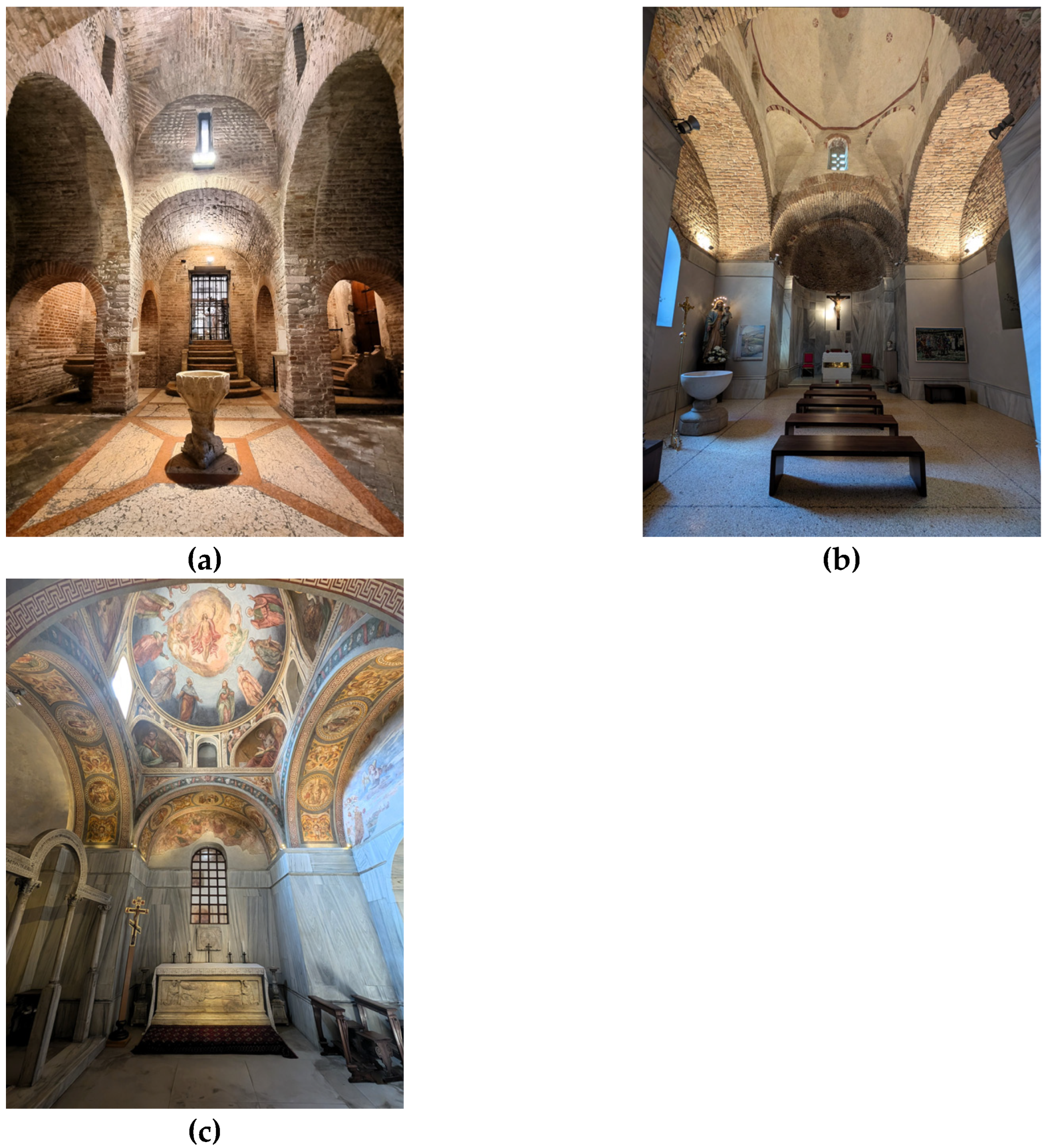
Figure 2.
Digital survey outputs of the sacellum of Sante Teuteria e Tosca in Verona, derived from point-cloud data: (a) axonometric section showing the plan; (b) roof plan; (c) transverse section; and (d) axonometric section.
Figure 2.
Digital survey outputs of the sacellum of Sante Teuteria e Tosca in Verona, derived from point-cloud data: (a) axonometric section showing the plan; (b) roof plan; (c) transverse section; and (d) axonometric section.
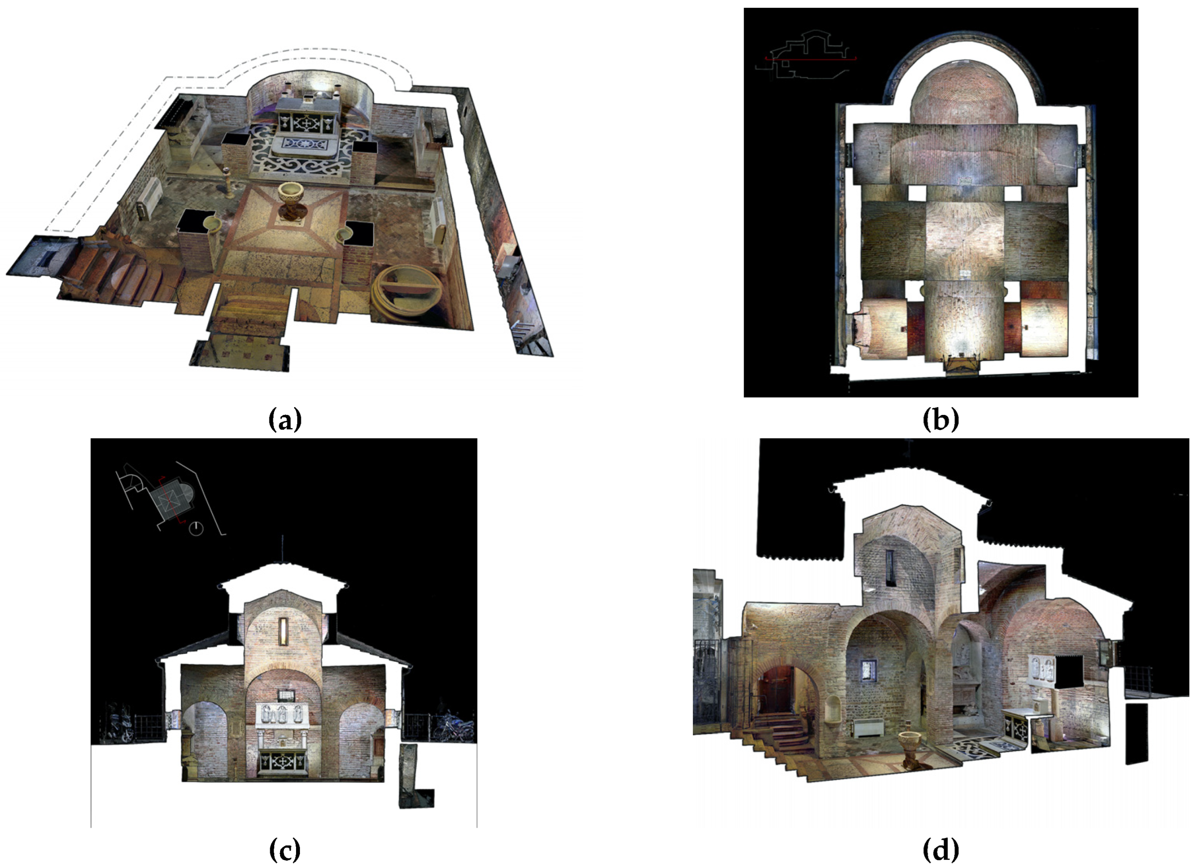
Figure 3.
Digital survey outputs of the sacellum of Santa Maria Mater Domini in Vicenza, derived from point-cloud data: (a) axonometric section showing the plan; (b) roof plan; (c) transverse section showing the spatial relationship between the Basilica of San Felice e Fortunato and the sacellum of Santa Maria Mater Domini; and (d) longitudinal section.
Figure 3.
Digital survey outputs of the sacellum of Santa Maria Mater Domini in Vicenza, derived from point-cloud data: (a) axonometric section showing the plan; (b) roof plan; (c) transverse section showing the spatial relationship between the Basilica of San Felice e Fortunato and the sacellum of Santa Maria Mater Domini; and (d) longitudinal section.
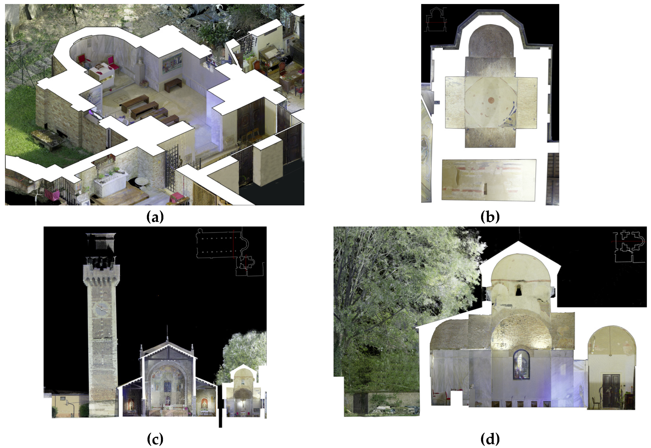
Figure 4.
Digital survey outputs of the sacellum of San Prosdocimo in Padua, derived from point-cloud data: (a) axonometric section; (b) roof plan; (c) axonometric section showing the plan; and (d) longitudinal section.
Figure 4.
Digital survey outputs of the sacellum of San Prosdocimo in Padua, derived from point-cloud data: (a) axonometric section; (b) roof plan; (c) axonometric section showing the plan; and (d) longitudinal section.
Disclaimer/Publisher’s Note: The statements, opinions and data contained in all publications are solely those of the individual author(s) and contributor(s) and not of MDPI and/or the editor(s). MDPI and/or the editor(s) disclaim responsibility for any injury to people or property resulting from any ideas, methods, instructions or products referred to in the content. |
© 2026 by the authors. Licensee MDPI, Basel, Switzerland. This article is an open access article distributed under the terms and conditions of the Creative Commons Attribution (CC BY) license (http://creativecommons.org/licenses/by/4.0/).
Copyright: This open access article is published under a Creative Commons CC BY 4.0 license, which permit the free download, distribution, and reuse, provided that the author and preprint are cited in any reuse.


