

Submitted:
12 July 2026
Posted:
14 July 2026
You are already at the latest version
Abstract
Dense urban settlements often depend on streets, thresholds, and residual spaces to support mobility, livelihoods, social interaction, and environmental adaptation. This study examines how street morphology, everyday public-space use, and climatic conditions interact within a compact urban settlement. An integrated single-case research design combined urban-context mapping, land-use analysis, historical building-footprint comparison, hourly activity mapping, social-interaction mapping, architectural sections, field observation, photographic documentation, and seasonal environmental interpretation. The findings show that the settlement benefits from proximity to major transport routes and urban services, but internal accessibility is constrained by narrow lanes, limited outward connections, fragmented pedestrian conditions, and uneven building–street interfaces. Incremental consolidation between 2000 and 2022 reduced open space and increased reliance on streets, thresholds, courtyards, and rooftops for movement, domestic activities, livelihood practices, and social interaction. Activity concentrations were strongest near mixed-use frontages, intersections, public facilities, and visible thresholds. Dense building arrangements provided useful shade but also restricted ventilation and intensified moisture retention. Standing water, inadequate drainage, exposed utilities, and waste accumulation further reduced environmental quality. The study concludes that context-sensitive upgrading should prioritize pedestrian continuity, drainage improvement, safer utilities, shaded social nodes, and protection of mixed-use livelihoods while retaining the settlement’s established socio-spatial structure.
Keywords:
street morphology
; everyday public space
; incremental development
; social interaction
; climate-responsive planning
; pedestrian accessibility
; settlement upgrading
1. Introduction
Rapid urban growth in low- and middle-income cities has produced dense settlements whose spatial structures develop through incremental building, changing household needs, informal economic activity, and limited institutional control. Such environments are often described primarily through deficiency—overcrowding, inadequate infrastructure, irregular plots, and restricted open space—yet this perspective can overlook the social, spatial, and economic systems through which residents organise everyday life. Urban informality is not simply the absence of planning; it is a mode of urbanisation shaped by flexible rules, negotiated access, and continuous adaptation [1]. The morphology of dense settlements therefore requires analysis as an evolving system in which buildings, streets, activities, and social relations are interconnected [2].
Street configuration is important because streets function as circulation routes, commercial interfaces, meeting places, service corridors, and extensions of domestic space. Space-syntax research shows that differences in spatial configuration influence pedestrian movement and the concentration of urban activities [3]. Network-based approaches similarly demonstrate that street centrality can reveal the accessibility and structural importance of individual routes within an urban system [4]. These relationships are significant in compact settlements, where changes in connectivity, permeability, or access may affect walking patterns, livelihood opportunities, and links to surrounding neighbourhoods. More broadly, evidence on the built environment indicates that density, land-use diversity, destination accessibility, and street design influence travel behaviour and support non-motorised movement [5].
The quality of public life in such settlements cannot be assessed only by measuring designated parks or squares. Public space is frequently produced through ordinary streets, intersections, thresholds, vacant plots, shaded edges, and temporarily appropriated areas. Its performance depends on accessibility, comfort, safety, inclusiveness, meaningful activity, and the capacity to support different users over time [6]. Consequently, public-space planning should respond to existing patterns of use rather than impose standardised physical solutions detached from local practices [7]. Hourly observation and behavioural mapping are useful for identifying when, where, and by whom spaces are occupied, as well as how domestic, educational, commercial, and social activities overlap.
Climate adds another critical dimension. In warm urban environments, street width, building height, orientation, enclosure, shade, ventilation, surface materials, and vegetation influence outdoor thermal conditions. Research in hot climates demonstrates that deeper street canyons can reduce daytime heat exposure by limiting solar radiation [8]. Trees and other landscape strategies may further improve thermal comfort through shading and evapotranspiration [9], while systematic evidence confirms that urban greening produces measurable cooling benefits [10]. However, interventions must be adapted to limited space, maintenance capacity, water availability, and existing patterns of movement.
This paper examines how spatial evolution, street connectivity, everyday activity, public-space appropriation, and climatic conditions interact within a dense urban settlement. It combines morphological mapping, street-network analysis, hourly behavioural observation, activity-route mapping, street sections, and microclimatic interpretation. The study aims to develop a climate-responsive regeneration framework that strengthens connectivity and environmental comfort while protecting social practices and local livelihoods. By linking physical form with temporal patterns of use, the research contributes a context-sensitive approach to upgrading dense settlements without erasing the everyday urban systems that sustain them.
2. Literature Review
Informal and incrementally developed settlements are increasingly understood as complex urban systems rather than undifferentiated areas of physical deprivation. A multidimensional investigation of informal settlements in Lahore demonstrates that morphology emerges through interactions among density, land use, accessibility, building configuration, open space and infrastructure [11]. This approach challenges interpretations that define informality solely through regulatory non-compliance. Informality can instead be understood as a mode of urbanization shaped by selective regulation, negotiated development and uneven institutional recognition [12]. Its physical expression includes irregular plots, mixed uses, narrow access networks and adaptable public–private interfaces [13]. Morphogenetic research further shows that these settlements evolve through subdivision, consolidation, building extension and functional intensification [14]. Their built form is therefore produced incrementally through identifiable spatial practices rather than random construction [15]. Topological analyses also demonstrate that early pathways, plot boundaries and access structures strongly influence subsequent development and infrastructure provision [16].
The challenges experienced by informal settlements extend beyond physical form. Comparative evidence from Lahore identifies persistent relationships among inadequate services, insecure tenure, overcrowding, environmental deterioration and limited institutional coordination [17]. These problems are often intensified when upgrading programmes treat settlements as isolated technical projects rather than socially embedded neighbourhoods. Earlier evaluations of upgrading practices found that interventions frequently failed because they lacked accurate spatial information and meaningful community participation [18]. Property rights and changing land values may also determine whether improvements benefit existing residents or encourage displacement [19]. Comparative studies associate more successful upgrading with institutional cooperation, incremental implementation and local participation [20]. Environmental deficiencies have direct health implications because inadequate water, sanitation, drainage and housing conditions increase residents’ exposure to preventable risks [21]. Health-sensitive upgrading must consequently combine physical improvement with social equity [22]. Informality can support affordable housing and livelihoods, but weak governance may transform these productive capacities into persistent vulnerability [23].
Planning standards represent another important dimension of settlement development. Research on housing schemes argues that inflexible requirements for plot sizes, setbacks, road widths and infrastructure can increase development costs and exclude lower-income households from formal housing markets [24]. Incremental housing finance can improve affordability by allowing households to construct and extend dwellings progressively rather than purchasing completed units [25]. Secure and flexible tenure arrangements can similarly encourage household investment without requiring immediate conformity to conventional ownership systems [26]. Sustainable housing strategies must therefore balance health and safety requirements with household income, local construction practices and long-term adaptability [27]. Housing provision in developing cities commonly involves combinations of public, private, household and community action rather than a single delivery system [28]. Home-based enterprises also demonstrate that dwellings frequently function as productive spaces, meaning that strict separation between residential and economic uses can undermine household livelihoods [29]. Planning reform should consequently establish essential safety thresholds while preserving opportunities for incremental adaptation.
Land-use and transport integration provides a broader framework for understanding how settlement morphology affects environmental performance. Recent work argues that coordinated land-use and transport planning can reduce travel demand, improve accessibility and limit energy consumption and pollution [30]. The built-environment literature consistently associates density, functional diversity, destination accessibility and pedestrian-oriented street design with lower levels of automobile dependence [31]. These relationships also have health implications because connected neighbourhoods can support active travel while reducing transport-related emissions [32]. Transit-oriented development extends this principle by concentrating activities around accessible public-transport corridors [33]. Nevertheless, physical proximity to transit does not automatically guarantee accessibility when walking routes are indirect, unsafe or discontinuous [34]. Transport infrastructure can also influence development differently depending on land markets, governance arrangements and pre-existing morphology [35]. Settlement regeneration should therefore link internal pedestrian networks with surrounding transport systems without allowing regional infrastructure to fragment local movement or community life.
Mobility patterns also reflect social and economic inequalities. Comparative mode-choice research shows that income, household structure, vehicle ownership, travel distance and access to public transport interact in shaping everyday mobility decisions [36]. These differences can create unequal access to employment, education and essential services. Built-environment research similarly finds that street continuity and destination accessibility influence whether walking becomes a practical daily mode [37]. Walkability depends not only on distance but also on safety, enclosure, visual interest, crossing conditions and pedestrian comfort [38]. Large-scale street-network studies demonstrate that intersection density, connectivity and route circuity vary substantially across urban forms [39]. Network-centrality measures can identify routes that are particularly important for movement, commercial exposure and neighbourhood integration [40]. Space-syntax research likewise shows that spatial configuration influences pedestrian flows and the location of activities [41]. Connectivity analysis should therefore consider how street structure interacts with household circumstances rather than assuming that all residents experience the same level of accessibility.
Questions of density must also consider residents’ perceptions and socio-cultural practices. Research on vertical urban development indicates that public acceptance depends on perceived accessibility, environmental quality, privacy, social interaction and cultural compatibility rather than building height alone [42]. Earlier reviews associate high-rise living with both potential advantages and concerns relating to social isolation, child supervision and restricted contact with outdoor space [43]. Evidence from Singapore shows that residents’ evaluations of high-rise housing are shaped by dwelling design, shared facilities and neighbourhood management [44]. Research on vertical family living further indicates that households may accept compact housing when schools, play spaces and daily services remain accessible [45]. Sustainability assessments of tall buildings emphasize that vertical density must be supported by energy efficiency, mixed use, public space and transport integration [46]. High-density development also requires attention to ventilation because building arrangement can obstruct neighbourhood airflow and intensify thermal discomfort [47]. Density should therefore be evaluated through lived experience and environmental performance, not only numerical measures.
Transit-oriented regeneration similarly requires attention to street-level conditions. A multi-stakeholder choice experiment demonstrates that people evaluate transit-oriented development through trade-offs among pedestrian space, greenery, commercial activity, traffic access and development intensity [48]. The established “three dimensions” of density, diversity and design provide a foundation for examining how urban form shapes travel demand [49]. However, the distinction between transit-adjacent and genuinely transit-oriented development shows that station proximity alone is insufficient when surrounding areas remain automobile-oriented or disconnected [50]. The node–place framework further explains that transport functions should be balanced with local activities and place quality [51]. Land-development models based on transit investment demonstrate that transport accessibility can generate substantial property and development benefits [52]. Reviews of transit-oriented development nevertheless identify affordability, institutional fragmentation and displacement as continuing concerns [53]. Regeneration strategies should consequently improve access to transport while protecting existing residents, informal businesses and everyday street activities.
Transport investment can also modify land-parcel structures and development intensity. Research examining bus rapid transit in Lahore found that corridor accessibility was associated with changes in parcel configuration and land development, illustrating how transport projects can reshape surrounding urban form [54]. These transformations should be evaluated alongside everyday public-space practices. Behavioural observation and movement tracing can reveal when streets, intersections, thresholds and residual spaces become socially active [55]. Public-space quality depends on accessibility, inclusiveness, safety, comfort and the range of activities supported [56]. Climate is especially important in dense settlements, where street geometry affects solar exposure and outdoor thermal comfort [57]. Street-canyon orientation and height-to-width ratios can provide shade but may also reduce ventilation [58]. Vegetation can lower local temperatures through shading and evapotranspiration, although cooling effects depend on planting form and spatial distribution [59]. Climate-responsive planning should therefore prioritize locations where heat exposure, limited vegetation and vulnerable users coincide [60]. Regeneration should combine connectivity, public-life observation and microclimatic improvement while retaining the settlement’s established social and economic systems
3. Materials and Methods
3.1. Research Design and Case-Study Scope
This study adopted an integrated single-case design to examine the relationship between urban form, everyday movement, public-space use, and environmental conditions in a dense urban settlement. The research combined morphological mapping, land-use interpretation, transport-context analysis, historical comparison, behavioural observation, activity-route mapping, architectural documentation, and climatic assessment. This design was selected because the retained analyses address connected spatial scales rather than a single physical variable. The settlement was therefore examined at the city scale through its surrounding transport and land-use context, at the neighbourhood scale through its evolving built form and internal activity structure, and at the micro scale through streets, thresholds, buildings, and environmental conditions.
The case was selected because it represents a compact and incrementally consolidated settlement with an elongated physical form, narrow internal lanes, irregular building arrangements, mixed residential and commercial functions, and intensive reliance on streets as movement and social spaces. Its proximity to city-scale transport infrastructure, combined with limited internal permeability and constrained public space, made it suitable for examining how metropolitan accessibility is translated into neighbourhood experience. The study does not claim statistical representativeness but provides an in-depth spatial interpretation of a dense, incrementally developed urban area.
3.2. Data Sources and Fieldwork
The analysis drew on satellite imagery, city- and settlement-scale base maps, historical building-footprint drawings, land-use maps, public-transport network information, field photographs, street plans, architectural sections, movement traces, hourly activity records, social-interaction maps, and climatic and environmental diagrams. The observational material formed part of fieldwork undertaken during July 2019, March–May 2021, September–November 2022, and August 2023. Only evidence directly related to the selected settlement and retained objectives was included.
Field visits were used to verify the settlement boundary, major access points, internal lanes, route junctions, commercial edges, public facilities, active thresholds, building conditions, utility infrastructure, shaded areas, drainage problems, and visible forms of public-space use. Observations were recorded through field notes, photographs, sketches, and annotated maps. Photographs documented street enclosure, informal commerce, movement, external stairs, raised thresholds, utilities, temporary shading, standing water, dampness, waste, and building–public-space relationships. Mapped and visual evidence supported interpretation at settlement and street scales.
3.3. Urban Context and Land-Use Analysis
The first analytical stage situated the settlement within the surrounding urban structure. Satellite imagery and city-scale mapping were used to identify its relationship with major roads, transport corridors, neighbouring districts, public institutions, recreational areas, water features, and other urban destinations. Public-transport routes were differentiated by mode, including conventional buses, minibuses or wagons, coaster services, mass-transit corridors, and track-based transport. The analysis was descriptive and focused on the contrast between the settlement’s apparent proximity to city-scale transport and the quality of its local connections.
At the settlement scale, buildings were classified according to their dominant functions. The mapped categories comprised residential, commercial, mixed commercial–residential, industrial, and public or institutional uses. Their distribution was examined to identify mixed-use concentrations, commercial edges, public destinations, and locations where non-residential functions generated movement, waiting, exchange, and informal gathering. This established the functional context for interpreting activity routes and social-interaction concentrations.
3.4. Spatial Evolution and Morphological Analysis
The settlement’s spatial evolution was reconstructed for 2000, 2005, 2010, 2015, 2020, and 2022. Historical imagery and successive building-footprint maps were compared using a consistent spatial extent and drawing scale. The comparison traced changes in built coverage, the occupation of previously open land, continuity between structures, development along the elongated settlement axis, and the changing relationship between buildings and circulation spaces.
The analysis emphasized morphological change rather than precise parcel-level measurement. Attention was given to areas where infill reduced internal gaps, later construction strengthened street enclosure, and consolidation altered access to open or residual spaces. The maps distinguished outward expansion from inward intensification and assessed how land occupation increased reliance on streets, courtyards, thresholds, and rooftops for activities not accommodated within private plots.
3.5. Street Connectivity and Section Analysis
Hourly observation was used to examine how residents connected domestic, educational, commercial, livelihood, and social destinations during the day. Three contrasting activity profiles were documented as illustrative behavioural cases rather than a representative household sample. For each profile, the approximate time, activity, location, and movement route were recorded and plotted on a settlement base map. The profiles included mobile food vending and neighbourhood interaction, teaching-related travel between home and educational facilities, and a woman’s routine combining household preparation, family-based livelihood activity, shopping, cooking, childcare, and evening domestic work.
Routes were interpreted in relation to internal lanes, continuity, destinations, corners, and active frontages. A sectional sequence for the woman’s profile showed transitions between private, semi-private, commercial, and public environments. Analysis focused on repeated destinations, route overlap, temporal change, and the multiple uses of the same lane.
3.6. Hourly Observation and Activity Mapping
Social-interaction mapping was undertaken to identify where recurring public activity was concentrated. Observed gathering, waiting, purchasing, sitting, standing, supervision, and conversation were associated with their corresponding street segments, junctions, commercial edges, public facilities, and mixed-use buildings. Larger mapped circles represented stronger concentrations of repeated activity rather than precise pedestrian counts.
Interaction nodes were compared with land use, route convergence, frontage activity, visibility, and places where residents could pause without obstructing movement. This distinguished highly active areas from segments dominated by through movement. The results represent relative social intensity rather than measured pedestrian volumes.
3.7. Public-Space and Climatic Assessment
Representative street and building conditions were documented through plans, axonometric drawings, longitudinal and transverse sections, and a detailed house section and elevation. The recorded characteristics included street width, building height, enclosure, frontage condition, setbacks, thresholds, steps, external stairs, balconies, courtyards, roofs, shop extensions, ground-floor uses, construction materials, and utility infrastructure. The drawings compared the wider outer street with narrower internal lanes.
The analysis treated the street and adjoining buildings as one connected spatial section. Particular attention was given to how uneven setbacks, active openings, shutters, raised thresholds, external stairs, rooftop use, incremental additions, and overhead utility cables affected movement, visibility, shade, access, and everyday occupation. Street performance was therefore interpreted through building form, frontage use, enclosure, and public–private transition rather than width alone.
3.8. Seasonal, Shade, and Environmental-Stress Assessment
The environmental assessment examined seasonal temperature, rainfall, sunshine duration, outdoor activity, solar exposure, shade, ventilation, moisture, and drainage conditions. Climatic diagrams were interpreted comparatively for March, May, July, and December to identify how changing seasonal conditions affected the timing and location of outdoor activity. Field photographs and sectional diagrams were then used to examine resident-led responses, including temporary canopies, recessed shopfronts, balconies, building projections, vegetation, covered thresholds, and building-generated shade.
Environmental stress was assessed through visual evidence of standing water, damp surfaces, waste accumulation, uneven paving, poorly positioned downpipes, raised thresholds, porous brickwork, and inadequate drainage. The analysis traced effects on pedestrian continuity, ground-floor spaces, and the building–street interface. Spontaneous vegetation in wet or permeable areas indicated possible links between water, planting, and local environmental improvement. The assessment was descriptive and did not use thermal or hydrological instruments.
4. Results
The integrated analysis revealed that the case-study settlement functions as a compact but highly differentiated socio-spatial system. Its physical structure is shaped by incremental consolidation, strong external transport accessibility, restricted internal permeability, mixed residential and livelihood functions, and intensive use of streets and building edges. The results are presented across six connected dimensions: urban context and land use, spatial evolution, everyday activity patterns, street morphology and connectivity, climatic and environmental conditions, and the resulting regeneration framework.
4.1. Urban Context, Land Use, and Transport Accessibility
The urban-scale analysis shows that the settlement occupies a narrow and elongated site enclosed by major transport and landscape elements. Although this configuration creates a clearly recognizable boundary, it also limits opportunities for outward expansion and concentrates development within a restricted footprint. The surrounding urban fabric contains educational, religious, commercial, recreational, and transport-related destinations, indicating that the settlement is not geographically isolated from the wider city. Its location therefore provides potential access to employment, education, public services, and urban mobility networks. However, physical proximity does not necessarily produce equivalent accessibility. The settlement’s internal lane structure, limited number of outward connections, and infrastructural edges mediate residents’ ability to reach the surrounding road and public-transport systems.
The visual survey presented in Figure 1 identifies a marked contrast between the settlement’s internal environment and its surrounding urban context. Wider roads, formal institutions, landscaped public areas, and major infrastructure are located close to a densely built area characterized by narrow lanes, mixed building conditions, exposed utility networks, and active street-based livelihoods. Schools, public facilities, recreational spaces, and commercial buildings are visible within the surrounding area, but the quality of the connections between these destinations and the settlement varies considerably. Major transport corridors provide citywide movement opportunities, yet their width, traffic intensity, and infrastructural character may also function as physical barriers for local pedestrian movement
Land-use mapping further demonstrates that residential buildings remain the dominant component of the settlement, but they are interspersed with commercial, mixed commercial–residential, public, and limited industrial functions. As shown in Figure 2, non-residential uses do not form a single planned centre. Instead, they appear as dispersed pockets and linear concentrations associated with accessible streets, intersections, and settlement edges. Mixed-use buildings are especially important because ground-floor commercial activities bring customers, vendors, deliveries, and waiting activity into spaces that also serve as residential access routes. These functions increase street vitality but can also reduce the effective width of already constrained lanes.
The city-scale transport map confirms that the settlement is positioned close to multiple public-transport systems, including buses, minibuses or wagons, coaster services, mass-transit corridors, and track-based transport. Figure 3 therefore indicates high potential metropolitan accessibility. Nevertheless, this accessibility is unevenly translated into the internal structure. Major routes pass close to the settlement, while many internal lanes remain indirect, narrow, and poorly equipped for continuous pedestrian movement. Residents consequently depend on short informal connections and intermediate transport services to move between the settlement and larger city networks.
4.2. Incremental Spatial Evolution and Settlement Consolidation
The chronological mapping demonstrates that the settlement’s present morphology is the outcome of cumulative and uneven consolidation rather than a single phase of development. Figure 4 traces the building footprint between 2000 and 2022 and shows a gradual reduction in unbuilt land, increasing continuity between structures, and intensification of the northern and central parts of the site.
In 2000, the settlement already displayed a recognizable elongated form, but the building fabric remained comparatively fragmented. Structures were concentrated more heavily toward the wider northern end, while the narrower southern extension contained more breaks between buildings. Open areas and discontinuities were still visible within the internal fabric, producing a more porous relationship between buildings and circulation spaces.
By 2005, infill development had increased the continuity of the northern cluster and extended the built footprint farther along the narrow southern portion. Expansion occurred mainly through the occupation of remaining spaces between existing buildings rather than through outward enlargement of the settlement boundary. This indicates that the surrounding infrastructure acted as a relatively fixed container, directing growth inward.
The 2010 mapping records a notable reconfiguration of the internal fabric. The number of individual building footprints increased, while some earlier structures appear to have been subdivided, extended, or replaced. The settlement became more spatially complex, with smaller internal gaps and a more intricate network of passages. This phase reflects both physical growth and household-level adaptation, including additions made to accommodate changing family size, rental demand, commercial activity, or home-based work.
By 2015 and 2020, the built form had become substantially more compact. The remaining vacant pockets were progressively occupied, especially in the wider northern and middle sections. The distinction between individual plots remained visible, but the settlement increasingly functioned as a continuous built mass. This continuity strengthened street enclosure and brought activities into closer proximity. At the same time, it reduced opportunities for ventilation, drainage, vegetation, informal play, and larger communal gatherings.
The 2022 footprint shows that the settlement had reached an advanced stage of horizontal consolidation. Most available land within the recognized boundary had been occupied, leaving relatively few open spaces other than circulation routes, small courtyards, setbacks, infrastructural edges, and irregular residual pockets. The elongated southern section also became more continuously developed, creating a stronger linear relationship between buildings and the principal internal route.
The sequence suggests that the major morphological change was not simply expansion in area but intensification within a constrained shape. Buildings became more continuous, internal open spaces contracted, and the street system assumed an increasingly important public role. As private plots were built more intensively, many functions that could no longer be contained inside dwellings—sitting, social contact, storage, vending, children’s play, and household work—were displaced or extended into lanes, thresholds, and roofs.
4.3. Everyday Mobility, Temporal Rhythms, and Social-Interaction Spaces
Hourly activity mapping shows that residents’ daily movements were predominantly local and closely connected to the settlement’s mixed-use structure. Instead of following a single journey between the home and one external destination, the three documented profiles involved repeated movement among homes, workplaces, schools, shops, neighbouring lanes, and street corners. The first activity profile remained strongly centred on the home and immediately surrounding streets (Figure 5a). Morning activities began with breakfast and watching television at home before shifting to the preparation and movement of a food stall. Livelihood activity continued through the neighbouring streets for much of the day, followed by walking, sitting, standing, and conversation at a street corner during the later period. This pattern demonstrates that livelihood and social interaction were not spatially separated. The mobile food activity depended on movement through residential streets, pedestrian visibility, access to local customers, and the availability of corners where the vendor could stop without completely blocking circulation.
The second profile extended farther through the surrounding neighbourhood and connected the home with a local school and an academy (Figure 5b). Following breakfast, the resident travelled to the neighbourhood school for teaching activities, returned home for lunch, and then moved to another educational location during the afternoon before returning home for dinner. This route demonstrates the importance of small educational destinations embedded within residential areas. Such facilities generate predictable morning and afternoon flows and indirectly activate surrounding streets through waiting, supervision, children’s movement, informal vending, and brief social exchanges among residents.
The third activity profile combined domestic work, livelihood activity, shopping, cooking, and childcare (Figure 5c). The day began with the preparation of materials for a shop, followed by work at a bakery with the resident’s husband. The resident then purchased goods from a nearby shop, returned home to cook, travelled to collect children from school, and finally returned home for evening activities. The route moved repeatedly between domestic, commercial, and educational spaces, demonstrating how everyday responsibilities were distributed across the neighbourhood rather than contained within a single building.
As illustrated in Figure 5, the three profiles differed in route length, destination, and primary activity, but all depended on the local street and lane network. Their movement was concentrated along a limited number of relatively continuous routes before dispersing through smaller passages near homes, schools, shops, and workplaces. The importance of these routes was not determined only by their physical width. They became significant because they connected repeatedly visited destinations and supported regular encounters between residents.
The combined activity profiles show that route meaning changed according to daily responsibilities. For the first resident, streets supported a mobile livelihood and later informal social interaction. For the second, the network mainly linked educational and domestic destinations. For the third, a woman’s routine connected household preparation, family-based work, local shopping, childcare, and evening domestic activities. These patterns show that the same internal lanes supported commercial circulation, school travel, household errands, and social contact at different times of the day.
This overlap was most visible around corners, shopfronts, and connecting lanes where residents could pause, wait, purchase goods, and interact with neighbours. Settlement activity also changed over time: mornings were shaped by domestic preparation, work, and school travel; midday was associated with household work, shopping, and livelihood movement; and later periods supported childcare, returning home, and informal social interaction.
Figure 6 presents a sectional representation of a woman resident’s daily routine across domestic, livelihood, shopping, childcare, and evening activities. The sections show how her everyday life moved continuously between the home, narrow lanes, the bakery, nearby shops, and the school route. They illustrate that mobility was not simply movement across space, but a sequence of transitions between private, semi-private, commercial, and public environments.
The social-interaction map shows that activity was unevenly distributed across the settlement rather than occurring uniformly along all streets. As illustrated in Figure 7, the strongest concentrations appeared in the wider northern section, where commercial and mixed-use buildings, public facilities, intersections, and several connecting lanes brought different groups of users into repeated contact. These locations supported not only movement but also waiting, purchasing, conversation, informal supervision, and short periods of sitting or standing. The clustering of activities indicates that socially active spaces emerged where multiple daily functions overlapped.
Smaller interaction nodes continued along the central and southern axis, especially near route junctions, active frontages, and buildings that attracted regular visitors. By contrast, sections with fewer entrances, limited land-use diversity, or weaker connections recorded lower levels of social activity. The findings suggest that social intensity depended on the combined influence of land use, street connectivity, visual exposure, and the availability of small spaces where residents could pause without blocking movement. Street width alone did not determine social activity; narrow lanes could remain highly active when they connected important destinations or contained visible thresholds, shops, and frequently used gathering points.
4.4. Street Morphology and the Building–Street Interface
Detailed mapping and sectional analysis reveal substantial variation between the settlement’s outer edge and its internal lanes. The principal outer street contains a comparatively wider movement zone and is more exposed to passing traffic, commercial activity, deliveries, and informal transport. Internal streets are narrower, more irregular, and more strongly enclosed by adjoining buildings. As shown in Figure 8(a), residential and mixed-use buildings are arranged along the settlement edge without uniform setbacks. Some buildings open directly onto the street, while others use steps, platforms, shop extensions, canopies, external stairs, and narrow transitional areas. These elements create a fragmented but active interface composed of multiple semi-private thresholds. Such thresholds support sitting, vending, household access, and informal surveillance, but they can also narrow pedestrian space and create local movement conflicts where several activities overlap.
The axonometric representation in Figure 8(b) demonstrates that the settlement is differentiated vertically as well as horizontally. Building heights vary considerably, roofs are actively used, and additions have accumulated through successive construction phases. Internal courtyards and rooftops provide environmental and social relief where ground-level open space is limited. External stairs, terraces, shopfronts, and elevated edges also connect domestic activities with the street and increase visual interaction across different levels. This vertical adaptation allows residents to extend domestic and social functions beyond the limited ground plane, although it also increases structural complexity and uneven access between buildings.
The longitudinal and transverse sections in Figure 8(c) show an uneven skyline produced by buildings of different ages, heights, materials, and stages of completion. Taller structures provide shade to neighbouring lanes and roofs but may also restrict airflow and increase enclosure. The transverse section highlights the contrast between the compact settlement and the broader transport corridors on either side. Internally, movement and everyday activities are compressed into narrow street sections, whereas the external corridors provide greater openness but weaker pedestrian comfort and limited integration with the settlement. Overall, the sections show that street performance is shaped by the combined effects of building height, frontage condition, threshold use, enclosure, and connection to surrounding movement systems.
The detailed house section and elevation in Figure 9 identify several recurring architectural characteristics. Ground floors may accommodate commercial or work-related uses, while upper floors contain shared family rooms and sleeping spaces. Roofs are used as external areas, partly compensating for the lack of ground-level open space. The use of local brick, mixed structural systems, exposed or faulty electrical networks, and incremental floor additions reveals a building stock shaped by affordability and gradual construction rather than a standardized development process.
These architectural conditions directly affect public-space performance. Ground-floor openings and shopfronts support activity and informal surveillance, but closed shutters and blank walls reduce street vitality. Raised thresholds protect interiors from water and dirt but also narrow the effective pedestrian path. External stairs and household objects extend into the public realm, providing seating or access while creating points of friction. Overhead utility cables increase visual and physical congestion, particularly where building facades are close together.
The findings therefore show that the street cannot be evaluated separately from adjoining buildings. The public realm is produced through the combined section of facade, threshold, street surface, utility network, temporary objects, and human activity. Street upgrading that addresses paving alone would leave many underlying problems unresolved, including drainage from buildings, unsafe electrical infrastructure, inaccessible thresholds, and weak environmental performance.
4.5. Seasonal Comfort, Shade, and Environmental Stress
The climatic analysis shows that the use of streets and shared spaces varied according to temperature, rainfall, sunshine duration, and seasonal conditions. As shown in Figure 10, March provided comparatively moderate temperatures and more favourable conditions for outdoor interaction. May experienced higher temperatures and prolonged solar exposure, which reduced the comfort of unshaded spaces. July combined high temperatures with increased rainfall, while December offered cooler conditions but shorter periods of daylight. These variations influenced when residents used outdoor spaces and which parts of the settlement remained active during different seasons.
During hotter periods, public-space activity shifted toward shaded building edges, narrow lanes, recessed shopfronts, and later hours of the day. Cooler or less exposed periods supported longer stays, informal gathering, children’s play, and rooftop use. The findings indicate that outdoor activity was not determined by temperature alone; rainfall, direct sunlight, ventilation, and the availability of protected edges also shaped residents’ spatial choices.
Resident-led shading strategies helped maintain commercial and social activities during hot conditions. As illustrated in Figure 11, temporary fabric canopies, recessed shopfronts, balconies, building projections, vegetation, and covered thresholds reduced direct solar exposure. These adaptations were especially important for small shops and street-based livelihood activities that depended on remaining visible and accessible throughout the day. Temporary shading allowed residents to continue working in locations that would otherwise become uncomfortable during periods of intense heat.
The relationship between density and shade was not uniform. Narrow internal lanes and closely spaced buildings generated substantial self-shading, while wider streets, settlement edges, and open areas remained more exposed. High density therefore provided some protection from daytime solar radiation, but it also restricted airflow and limited opportunities for vegetation. In several locations, the environmental benefit of shade was offset by weak ventilation, moisture retention, and overcrowded street conditions.
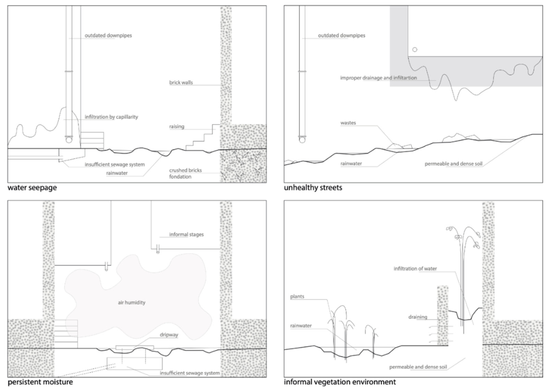
Water management emerged as the settlement’s most visible environmental weakness. As shown in Figure 12, several internal lanes contained standing water, damp surfaces, scattered waste, and uneven walking conditions. These problems reduced the usable width of the street and forced pedestrians to move around wet or contaminated areas. The impacts were particularly significant for children, older residents, people carrying goods, and those moving between homes and local services.
The observed conditions resulted from several interconnected factors. Outdated or poorly positioned downpipes discharged water close to walls and foundations, while insufficient sewerage capacity limited the removal of rainwater and household wastewater. Poorly graded surfaces and irregular repairs created depressions where water accumulated. Porous brickwork and cracks also allowed moisture to rise through capillary action, contributing to persistent dampness in lower walls and ground-floor spaces.
Raised thresholds protected individual interiors from surface water but did not resolve the wider drainage problem. In some cases, they redirected water toward adjoining properties or the centre of the lane. Waste deposited near drains and low points further obstructed water movement and intensified unsanitary conditions. Persistent dampness also weakened the building–street interface by damaging walls, increasing maintenance needs, and reducing the comfort and health of ground-floor rooms.
The diagrams additionally show that vegetation appeared spontaneously in some wet or permeable areas. This suggests that water should not be treated only as waste but also as a potentially reusable environmental resource. Rainwater and relatively clean greywater could support planting and small-scale landscape systems if separated from harmful wastewater and treated appropriately. The findings therefore support an integrated approach combining improved drainage, wastewater separation, permeable surfaces, planted filtration, and routine waste management.
5. Discussion and Policy Implications
The findings demonstrate that public-space performance in a dense urban settlement cannot be explained through street form, accessibility, land use, or climate in isolation. It emerges from the interaction between incremental morphology, everyday movement, mixed-use activity, building–street interfaces, and environmental conditions. The settlement is located close to major transport routes and urban services, yet its residents experience these advantages through narrow internal lanes, limited outward connections, and uneven pedestrian conditions. This confirms that transport proximity does not necessarily provide effective accessibility when local routes are indirect, obstructed, or physically uncomfortable, as emphasized in earlier accessibility and built-environment research [31,34]. The results therefore distinguish metropolitan accessibility from neighbourhood permeability: the settlement is well positioned within the city but only partially integrated at the pedestrian scale.
The spatial-evolution analysis further shows that the present urban form resulted primarily from inward consolidation rather than outward expansion. Between 2000 and 2022, vacant spaces declined, buildings became more continuous, and streets, thresholds, courtyards, and roofs assumed greater importance as shared environments. This supports morphological research describing informal development as an incremental and rule-based process involving subdivision, infill, extension, and functional intensification [11,14,15]. However, the findings also reveal the environmental consequences of this process. Increased continuity strengthens proximity, active frontage, and neighbourhood interaction, but can reduce ventilation, drainage capacity, vegetation, and flexible open space. Planning responses based on conventional clearance or standardized layouts would overlook these internal adaptations and could disrupt established livelihood and social networks. Watson’s critique of planning approaches that displace low-income residents is particularly relevant: technically ordered redevelopment may produce spatial improvement while weakening affordability, access, and social continuity [61].
The activity profiles provide further evidence that streets function as everyday social infrastructure rather than simple movement corridors. Residents used the same lanes for vending, teaching-related travel, shopping, childcare, household tasks, waiting, and conversation. These patterns support earlier findings that public-space quality depends on the activities and interactions accommodated rather than solely on formal design [55,56]. The woman’s activity profile is especially important because it demonstrates how domestic responsibilities, family-based work, shopping, and childcare are connected through short neighbourhood routes. Improvements to these routes would therefore have combined mobility, livelihood, care, and social benefits. Conversely, closing or widening lanes without understanding these routines could disproportionately affect residents whose daily activities depend on local accessibility.
Social-interaction mapping showed that the strongest activity concentrations occurred where commercial uses, public facilities, route junctions, visible thresholds, and opportunities to pause overlapped. This finding reinforces space-syntax and network research showing that configuration shapes movement and co-presence [40,41], but it also demonstrates that configuration alone does not explain social intensity. Narrow lanes could remain highly active when they contained shops, entrances, educational destinations, and repeated household movement. Policy should therefore recognize active nodes as locally produced public spaces. Rather than replacing them with a single formal plaza, upgrading should reinforce their existing functions through improved surfaces, lighting, seating, shade, waste collection, and clearly managed vending areas.
The building–street analysis also confirms that public space is formed through the combined relationship among facades, thresholds, stairs, roofs, utilities, and human activity. Raised entrances protect dwellings from surface water but reduce the effective pedestrian width. External stairs and shop extensions support household access and livelihoods but may create points of friction. Rooftops and courtyards compensate for limited open space, particularly where street-level activity is constrained. These conditions support multidimensional interpretations of informal morphology [11,17], while showing why paving-only programmes are insufficient. Upgrading should address the complete street section, including facade drainage, electrical safety, threshold accessibility, roof-water discharge, and the organization of temporary objects.
The climatic results indicate that density provides both protection and exposure. Closely spaced buildings create shade during hot periods, supporting walking and street-based work, but may also restrict ventilation and retain moisture. Wider streets improve openness but expose users to greater solar radiation. This confirms previous research showing that street geometry can reduce daytime heat while producing ventilation trade-offs [57,58]. Resident-led canopies, recessed shopfronts, vegetation, and covered thresholds should therefore be treated as locally adapted environmental infrastructure rather than visual disorder. Policies could provide simple design standards for safe canopies, lightweight shading, climbing vegetation, and shared shaded nodes without imposing expensive standardized structures.
Water and drainage require more urgent intervention. Standing water, blocked flows, waste accumulation, poorly positioned downpipes, and damp walls were not isolated building defects; they formed a connected settlement-scale problem. Similar research shows that flood and drainage risks in low-income settlements are intensified by hard surfaces, inadequate drainage, weak waste management, and limited public investment [65]. Street and building improvements should therefore be coordinated through small drainage catchments rather than implemented household by household. Water-sensitive measures could include graded surfaces, protected drains, downpipe connections, permeable pockets, planted filtration strips, and routine removal of solid waste. The wider urban-drainage literature supports integrated systems that manage runoff close to its source rather than relying only on conventional underground infrastructure [67].
These measures should form part of an incremental, community-based upgrading programme. co-production research demonstrates that partnerships between residents and public agencies can improve basic services while also strengthening local influence over decisions [62]. Thailand’s Baan Mankong programme similarly illustrates how community organizations, infrastructure subsidies, and citywide partnerships can support in-situ upgrading at scale [63]. For the present settlement, residents should participate in identifying critical routes, drainage points, active social nodes, unsafe utilities, and shading priorities. Public agencies would remain responsible for technical standards, infrastructure coordination, finance, and long-term maintenance; participation should not transfer institutional responsibilities to households.
Climate resilience policy should also extend beyond physical protection. Informal-settlement resilience depends on improving basic services, reducing exposure, and supporting the capacities residents already use to manage risk [64]. Resilience should be evaluated by asking who benefits, which functions are protected, and whether interventions support adaptation without reinforcing inequality [66]. A “safe-to-fail” approach is appropriate, using small, modular, monitored interventions that can be adjusted over time rather than one inflexible redevelopment project [69].
Nature-based interventions could provide shade, drainage, cooling, and social-space benefits, but they should be applied selectively. Nature-based solutions can generate environmental, health, social, and economic co-benefits when their trade-offs are assessed across sectors [68]. However, new greenery and public-space investment can raise land values and create displacement pressures if tenure and affordability protections are absent [70]. Consequently, environmental upgrading should be paired with anti-displacement measures, secure occupancy, protection of small businesses, and transparent decision-making.
The policy implication is not to redesign the settlement as a completely new urban form but to improve the systems through which its existing form operates. Priority actions should include strengthening pedestrian connections to surrounding transport, upgrading active social nodes, coordinating building and street improvements, managing drainage at multiple scales, supporting resident-led shade, and protecting livelihoods and tenure. This incremental approach recognizes that the settlement’s streets are simultaneously mobility routes, economic spaces, social settings, and environmental infrastructure.
6. Conclusions
This study examined how street morphology, everyday movement, public-space use, and environmental conditions interact within a dense urban settlement. The findings show that the settlement is not spatially isolated from the wider city, as it is located near major transport routes, institutions, commercial areas, and public facilities. However, this external accessibility is weakened by narrow internal lanes, limited outward connections, fragmented pedestrian routes, and uneven building–street conditions. Accessibility therefore depends not only on geographic proximity but also on the continuity, safety, and comfort of the routes through which residents reach surrounding services.
The spatial-evolution analysis demonstrated that the settlement developed primarily through gradual infill and consolidation between 2000 and 2022. As vacant land declined and buildings became more continuous, streets, thresholds, courtyards, and rooftops assumed increasingly important social and functional roles. Activity mapping further revealed that residents’ daily routines were organized through short and overlapping journeys connecting homes, schools, shops, workplaces, and gathering points. These findings confirm that internal streets function as multifunctional environments supporting mobility, livelihoods, household responsibilities, childcare, and social interaction rather than as movement corridors alone.
Social activity was concentrated around mixed-use frontages, intersections, public facilities, and locations where several routes converged. The building–street analysis also showed that shopfronts, raised thresholds, external stairs, rooftops, and temporary extensions directly shape pedestrian movement and public-space quality. Climatic conditions added another layer of variation. Narrow streets and dense building arrangements provided useful shade during hot periods, but they also restricted airflow and intensified moisture retention. Temporary canopies and covered edges supported outdoor livelihoods, while poor drainage, standing water, dampness, and waste accumulation remained major environmental concerns.
The study concludes that improvement should focus on incremental and context-sensitive upgrading rather than comprehensive physical replacement. Priority actions include strengthening pedestrian connections, improving drainage and utility safety, supporting shaded social nodes, protecting mixed-use activity, and coordinating building and street interventions. Such measures should preserve existing livelihoods and social practices while addressing environmental and accessibility weaknesses. Although the study is based on one case and selected activity profiles, it offers a transferable approach for understanding dense settlements as interconnected socio-spatial systems whose regeneration should be informed by morphology, daily life, and climate together.
Author Contributions
Conceptualization, M.M.A.; methodology, M.M.A.; software, M.M.A.; validation, M.M.A.; formal analysis, M.M.A.; investigation, M.M.A.; resources, M.M.A.; data curation, M.M.A.; writing—original draft preparation, M.M.A.; writing—review and editing, M.M.A.; visualization, M.M.A.; project administration, M.M.A. The author has read and agreed to the published version of the manuscript.
Institutional Review Board Statement
The study was approved by the Ethics Committee, SMEC (Sociaal Maatschappelijke Ethische Commissie) of KU Leuven. The ethical concerns for the article have been evaluated on the level of the project (code 3E181030). Based on these approvals, the study complies with GDPR requirements.
Informed Consent Statement
Informed consent was obtained from all individual participants involved in the study.
Data Availability Statement
The data supporting the findings of this study are available from the corresponding author upon reasonable request.
Conflicts of Interest
The authors declare no conflict of interest.
References
- Roy, A. Urban informality: Toward an epistemology of planning. J. Am. Plan. Assoc. 2005, 71, 147–158. [Google Scholar] [CrossRef]
- Dovey, K.; King, R. Forms of informality: Morphology and visibility of informal settlements. Built Environ. 2011, 37, 11–29. [Google Scholar] [CrossRef]
- Hillier, B.; Penn, A.; Hanson, J.; Grajewski, T.; Xu, J. Natural movement: Or, configuration and attraction in urban pedestrian movement. Environ. Plan. B Plan. Des. 1993, 20, 29–66. [Google Scholar] [CrossRef]
- Porta, S.; Crucitti, P.; Latora, V. The network analysis of urban streets: A primal approach. Environ. Plan. B Plan. Des. 2006, 33, 705–725. [Google Scholar] [CrossRef]
- Ewing, R.; Cervero, R. Travel and the built environment: A meta-analysis. J. Am. Plan. Assoc. 2010, 76, 265–294. [Google Scholar] [CrossRef]
- Mehta, V. Evaluating public space. J. Urban Des. 2014, 19, 53–88. [Google Scholar] [CrossRef]
- Carmona, M. Principles for public space design, planning to do better. Urban Des. Int. 2019, 24, 47–59. [Google Scholar] [CrossRef]
- Johansson, E. Influence of urban geometry on outdoor thermal comfort in a hot-dry climate: A study in Fez, Morocco. Build. Environ. 2006, 41, 1326–1338. [Google Scholar] [CrossRef]
- Shashua-Bar, L.; Pearlmutter, D.; Erell, E. The cooling efficiency of urban landscape strategies in a hot-dry climate. Landsc. Urban Plan. 2009, 92, 179–186. [Google Scholar] [CrossRef]
- Bowler, D.E.; Buyung-Ali, L.; Knight, T.M.; Pullin, A.S. Urban greening to cool towns and cities: A systematic review of the empirical evidence. Landsc. Urban Plan. 2010, 97, 147–155. [Google Scholar] [CrossRef]
- Arif, M.M.; Ahsan, M.; Devisch, O.; Schoonjans, Y. Integrated approach to explore multidimensional urban morphology of informal settlements: The case studies of Lahore, Pakistan. Sustainability 2022, 14, 7788. [Google Scholar] [CrossRef]
- Banks, N.; Lombard, M.; Mitlin, D. Urban informality as a site of critical analysis. J. Dev. Stud. 2020, 56(2), 223–238. [Google Scholar] [CrossRef]
- Jones, P. The shaping of form and structure in informal settlements: a case study of order and rules in Lebak Siliwangi, Bandung, Indonesia. J. Reg. City Plan. 2019, 30(1), 43–61. [Google Scholar] [CrossRef]
- Dovey, K.; van Oostrum, M.; Chatterjee, I.; Shafique, T. Towards a morphogenesis of informal settlements. Habitat Int. 2020, 104, 102240. [Google Scholar] [CrossRef]
- Kamalipour, H.; Dovey, K. Incremental production of urban space: A typology of informal design. Habitat Int. 2020, 98, 102133. [Google Scholar] [CrossRef]
- Brelsford, C.; Martin, T.; Hand, J.; Bettencourt, L.M.A. Toward cities without slums: Topology and the spatial evolution of neighborhoods. Sci. Adv. 2018, 4, eaar4644. [Google Scholar] [CrossRef] [PubMed]
- Arif, M.M.; Devisch, O.; Schoonjans, Y. Examining the intricacies and perpetual issues in urban informal settlements: Lessons from two case studies of informal settlements in Lahore, Pakistan. J. Art. Archit. Built Environ. 2023, 6, 62–93. [Google Scholar] [CrossRef]
- Abbott, J. An analysis of informal settlement upgrading and critique of existing methodological approaches. Habitat Int. 2002, 26, 303–315. [Google Scholar] [CrossRef]
- Mukhija, V. An analytical framework for urban upgrading: Property rights, property values and physical attributes. Habitat Int. 2002, 26, 553–570. [Google Scholar] [CrossRef]
- Minnery, J.; Argo, T.; Winarso, H.; Hau, D.; Veneracion, C.C.; Forbes, D.; Childs, I. Slum upgrading and urban governance: Case studies in three South East Asian cities. Habitat Int. 2013, 39, 162–169. [Google Scholar] [CrossRef]
- Sverdlik, A. Ill-health and poverty: A literature review on health in informal settlements. Environ. Urban. 2011, 23, 123–155. [Google Scholar] [CrossRef]
- Corburn, J.; Sverdlik, A. Slum upgrading and health equity. Int. J. Environ. Res. Public Health 2017, 14, 342. [Google Scholar] [CrossRef] [PubMed]
- Azunre, G.A.; Amponsah, O.; Takyi, S.A.; Mensah, H.; Braimah, I. Urban informalities in sub-Saharan Africa: A solution for or barrier against sustainable city development? World Dev. 2022, 152, 105782. [Google Scholar] [CrossRef]
- Asim, M.; Arif, M.M.; Aziz, M.A.; Adeel, A. Relaxing the planning standards of housing scheme: An approach to enhance the affordability of poor. Tech. J. Univ. Eng. Technol. Taxila 2016, 21 No DOI assigned. [Google Scholar]
- Ferguson, B.; Smets, P. Finance for incremental housing: Current status and prospects for expansion. Habitat Int. 2010, 34, 288–298. [Google Scholar] [CrossRef]
- Payne, G. Urban land tenure policy options: Titles or rights? Habitat Int. 2001, 25, 415–429. [Google Scholar] [CrossRef]
- Smets, P.; van Lindert, P. Sustainable housing and the urban poor. Int. J. Urban Sustain. Dev. 2016, 8, 1–9. [Google Scholar] [CrossRef]
- Keivani, R.; Werna, E. Modes of housing provision in developing countries. Prog. Plan. 2001, 55, 65–118. [Google Scholar] [CrossRef]
- Gough, K.V.; Kellett, P. Housing consolidation and home-based income generation: Evidence from self-help settlements in two Colombian cities. Cities 2001, 18, 235–247. [Google Scholar] [CrossRef]
- Sheikh, N.B.; Arif, M.M.; Laverge, J.; Delghust, M. Integrating land use and transport for energy efficiency: Enabling urban transformation and combating environmental pollution. CIB Conf. 2025, 1, 9. [Google Scholar] [CrossRef]
- Ewing, R.; Cervero, R. Travel and the built environment: A meta-analysis. J. Am. Plan. Assoc. 2010, 76, 265–294. [Google Scholar] [CrossRef]
- Frank, L.D.; Sallis, J.F.; Conway, T.L.; Chapman, J.E.; Saelens, B.E.; Bachman, W. Many pathways from land use to health: Associations between neighborhood walkability and active transportation, body mass index, and air quality. J. Am. Plan. Assoc. 2006, 72, 75–87. [Google Scholar] [CrossRef]
- Ibraeva, A.; Correia, G.H.A.; Silva, C.; Antunes, A.P. Transit-oriented development: A review of research achievements and challenges. Transp. Res. Part A Policy Pract. 2020, 132, 110–130. [Google Scholar] [CrossRef]
- Papa, E.; Bertolini, L. Accessibility and transit-oriented development in European metropolitan areas. J. Transp. Geogr. 2015, 47, 70–83. [Google Scholar] [CrossRef]
- Knowles, R.D.; Ferbrache, F.; Nikitas, A. Transport’s historical, contemporary and future role in shaping urban development: Re-evaluating transit-oriented development. Cities 2020, 99, 102607. [Google Scholar] [CrossRef]
- Arif, M.M.; Adeel, A.; Sheikh, N.B. Mode choice patterns and socio-spatial equity in contrasting transitional urban mobility systems. TeMA—Journal Land Use Mobil. Environ. 2025, 18, 271–292. [Google Scholar] [CrossRef] [PubMed]
- Handy, S.L.; Boarnet, M.G.; Ewing, R.; Killingsworth, R.E. How the built environment affects physical activity: Views from urban planning. Am. J. Prev. Med. 2002, 23, 64–73. [Google Scholar] [CrossRef] [PubMed]
- Southworth, M. Designing the walkable city. J. Urban Des. 2005, 10, 246–268. [Google Scholar] [CrossRef]
- Boeing, G. A multi-scale analysis of 27,000 urban street networks: Every US city, town, urbanized area, and Zillow neighborhood. Environ. Plan. B Urban Anal. City Sci. 2020, 47, 590–608. [Google Scholar] [CrossRef]
- Porta, S.; Crucitti, P.; Latora, V. The network analysis of urban streets: A primal approach. Environ. Plan. B Plan. Des. 2006, 33, 705–725. [Google Scholar] [CrossRef]
- van Nes, A. Spatial configurations and walkability potentials. Measuring urban compactness with space syntax. Sustainability 2021, 13(11), 5785. [Google Scholar] [CrossRef]
- Al Sulaimani, G.; Arif, M.M.; Adeel, A.; Basheer, M.A.; Sheikh, N.B. Rethinking vertical cities: The influence of public perception on design, form, and socio-cultural integration. Societies 2025, 15, 250. [Google Scholar] [CrossRef]
- Gifford, R. The consequences of living in high-rise buildings. Archit. Sci. Rev. 2007, 50, 2–17. [Google Scholar] [CrossRef]
- Yuen, B.; Yeh, A.; Appold, S.J.; Earl, G.; Ting, J.; Kwee, L.K. High-rise living in Singapore public housing. Urban Stud. 2006, 43, 583–600. [Google Scholar] [CrossRef]
- Karsten, L. Middle-class households with children on vertical family living in Amsterdam. Habitat Int. 2015, 47, 241–248. [Google Scholar] [CrossRef]
- Al-Kodmany, K. The sustainability of tall building developments: A conceptual framework. Buildings 2018, 8, 7. [Google Scholar] [CrossRef]
- Ng, E. Policies and technical guidelines for urban planning of high-density cities: Air ventilation assessment of Hong Kong. Build. Environ. 2009, 44, 1478–1488. [Google Scholar] [CrossRef] [PubMed]
- Adeel, A.; Arif, M.M.; Sheikh, N.B.; Ahsan, M.; Bashir, N. Designing livable transit-oriented development: A multi-stakeholder choice experiment on street-level trade-offs. Int. J. Civ. Infrastruct. 2025, 8, 138–154. [Google Scholar] [CrossRef]
- Cervero, R.; Kockelman, K. Travel demand and the three Ds: Density, diversity, and design. Transp. Res. Part D. Transp. Environ. 1997, 2, 199–219. [Google Scholar] [CrossRef]
- Renne, J.L. From transit-adjacent to transit-oriented development. Local Environ. 2009, 14, 1–15. [Google Scholar] [CrossRef]
- Bertolini, L. Spatial development patterns and public transport: The application of an analytical model in the Netherlands. Plan. Pract. Res. 1999, 14, 199–210. [Google Scholar] [CrossRef]
- Cervero, R.; Murakami, J. Rail and property development in Hong Kong: Experiences and extensions. J. Am. Plan. Assoc. 2009, 75, 201–218. [Google Scholar] [CrossRef]
- Kamruzzaman, M.; Baker, D.; Washington, S.; Turrell, G. Advance transit-oriented development typology: Case study in Brisbane, Australia. J. Transp. Geogr. 2014, 34, 54–70. [Google Scholar] [CrossRef]
- Mehmood, R.T.; Shah, M.Z.; Moeinaddini, M.; Arif, M.M.; Chuhdary, R.; Tahira, M. Assessing urban land parcel dynamics driven by bus rapid transit as an exclusive transit route. Urban Sci. 2024, 8, 227. [Google Scholar] [CrossRef]
- Gehl, J.; Svarre, B. How to Study Public Life; Island Press: Washington, DC, USA, 2013. [Google Scholar] [CrossRef]
- Mehta, V. Evaluating public space. J. Urban Des. 2014, 19, 53–88. [Google Scholar] [CrossRef]
- Johansson, E. Influence of urban geometry on outdoor thermal comfort in a hot-dry climate: A study in Fez, Morocco. Build. Environ. 2006, 41, 1326–1338. [Google Scholar] [CrossRef]
- Ali-Toudert, F.; Mayer, H. Numerical study on the effects of aspect ratio and orientation of an urban street canyon on outdoor thermal comfort in hot and dry climate. Build. Environ. 2006, 41, 94–108. [Google Scholar] [CrossRef]
- Bowler, D.E.; Buyung-Ali, L.; Knight, T.M.; Pullin, A.S. Urban greening to cool towns and cities: A systematic review of the empirical evidence. Landsc. Urban Plan. 2010, 97, 147–155. [Google Scholar] [CrossRef]
- Norton, B.A.; Coutts, A.M.; Livesley, S.J.; Harris, R.J.; Hunter, A.M.; Williams, N.S.G. Planning for cooler cities: A framework to prioritise green infrastructure to mitigate high temperatures in urban landscapes. Landsc. Urban Plan. 2015, 134, 127–138. [Google Scholar] [CrossRef]
- Watson, V. “The planned city sweeps the poor away…”: Urban planning and twenty-first-century urbanisation. Prog. Plan. 2009, 72, 151–193. [Google Scholar] [CrossRef]
- Mitlin, D. With and beyond the state—Co-production as a route to political influence, power and transformation for grassroots organizations. Environ. Urban. 2008, 20, 339–360. [Google Scholar] [CrossRef]
- Boonyabancha, S. Baan Mankong: Going to scale with “slum” and squatter upgrading in Thailand. Environ. Urban. 2005, 17, 21–46. [Google Scholar] [CrossRef]
- Satterthwaite, D.; Archer, D.; Colenbrander, S.; Dodman, D.; Hardoy, J.; Mitlin, D.; Patel, S. Building resilience to climate change in informal settlements. One Earth 2020, 2, 143–156. [Google Scholar] [CrossRef]
- Douglas, I.; Alam, K.; Maghenda, M.; McDonnell, Y.; McLean, L.; Campbell, J. Unjust waters: Climate change, flooding and the urban poor in Africa. Environ. Urban. 2008, 20, 187–205. [Google Scholar] [CrossRef]
- Meerow, S.; Newell, J.P.; Stults, M. Defining urban resilience: A review. Landsc. Urban Plan. 2016, 147, 38–49. [Google Scholar] [CrossRef]
- Fletcher, T.D.; Shuster, W.; Hunt, W.F.; Ashley, R.; Butler, D.; Arthur, S.; Trowsdale, S.; Barraud, S.; Semadeni-Davies, A.; Bertrand-Krajewski, J.-L.; et al. SUDS, LID, BMPs, WSUD and more—The evolution and application of terminology surrounding urban drainage. Urban Water J. 2015, 12, 525–542. [Google Scholar] [CrossRef]
- Raymond, C.M.; Frantzeskaki, N.; Kabisch, N.; Berry, P.; Breil, M.; Nita, M.R.; Geneletti, D.; Calfapietra, C. A framework for assessing and implementing the co-benefits of nature-based solutions in urban areas. Environ. Sci. Policy 2017, 77, 15–24. [Google Scholar] [CrossRef]
- Ahern, J. From fail-safe to safe-to-fail: Sustainability and resilience in the new urban world. Landsc. Urban Plan. 2011, 100, 341–343. [Google Scholar] [CrossRef]
- Anguelovski, I.; Connolly, J.J.T.; Pearsall, H.; Shokry, G.; Checker, M.; Maantay, J.; Gould, K.; Lewis, T.; Maroko, A.; Roberts, J.T. Why green “climate gentrification” threatens poor and vulnerable populations. Proc. Natl. Acad. Sci. USA 2019, 116, 26139–26143. [Google Scholar] [CrossRef]
Figure 1.
Urban setting of the case-study settlement and its relationship with surrounding transport infrastructure, institutions, public spaces, and neighbourhood streets. Source: authors.
Figure 1.
Urban setting of the case-study settlement and its relationship with surrounding transport infrastructure, institutions, public spaces, and neighbourhood streets. Source: authors.
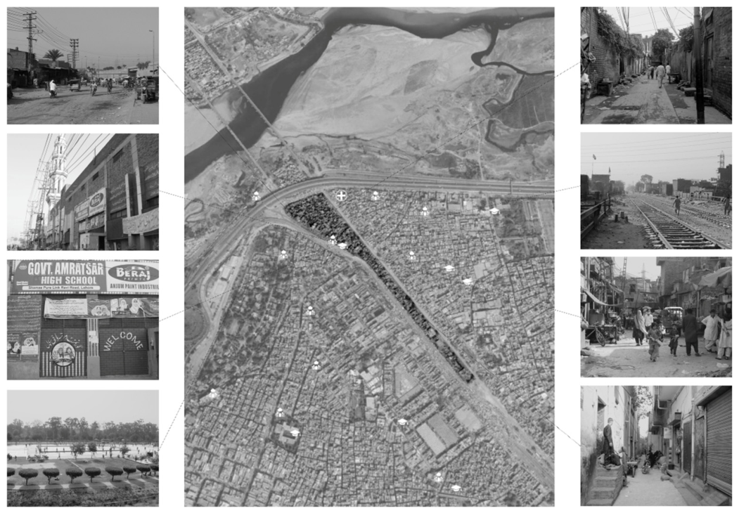
Figure 2.
Land-use distribution within and around the case-study settlement, showing commercial, industrial, public, and mixed commercial–residential functions. Source: authors.
Figure 2.
Land-use distribution within and around the case-study settlement, showing commercial, industrial, public, and mixed commercial–residential functions. Source: authors.
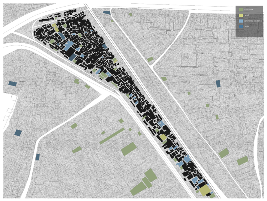
Figure 3.
City-scale multimodal public-transport network and the settlement’s accessibility to major transit routes. Source: authors.
Figure 3.
City-scale multimodal public-transport network and the settlement’s accessibility to major transit routes. Source: authors.
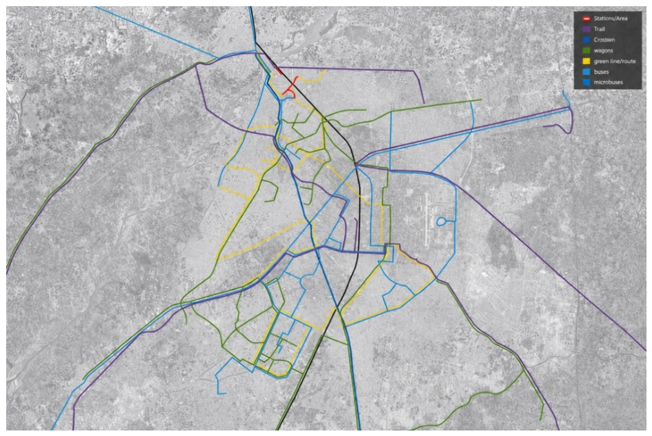
Figure 4.
Incremental spatial evolution of the case-study settlement from 2000 to 2022. Source: authors.
Figure 4.
Incremental spatial evolution of the case-study settlement from 2000 to 2022. Source: authors.
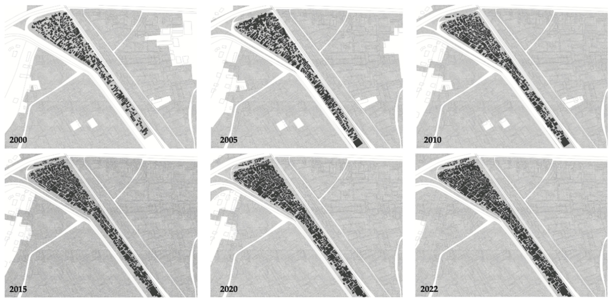
Figure 5.
Hourly activity profiles and movement routes of three residents: (a) mobile food-vending and neighbourhood interaction; (b) teaching-related movement between the home, school, and academy; and (c) domestic, livelihood, shopping, and childcare activities. Source: authors.
Figure 5.
Hourly activity profiles and movement routes of three residents: (a) mobile food-vending and neighbourhood interaction; (b) teaching-related movement between the home, school, and academy; and (c) domestic, livelihood, shopping, and childcare activities. Source: authors.
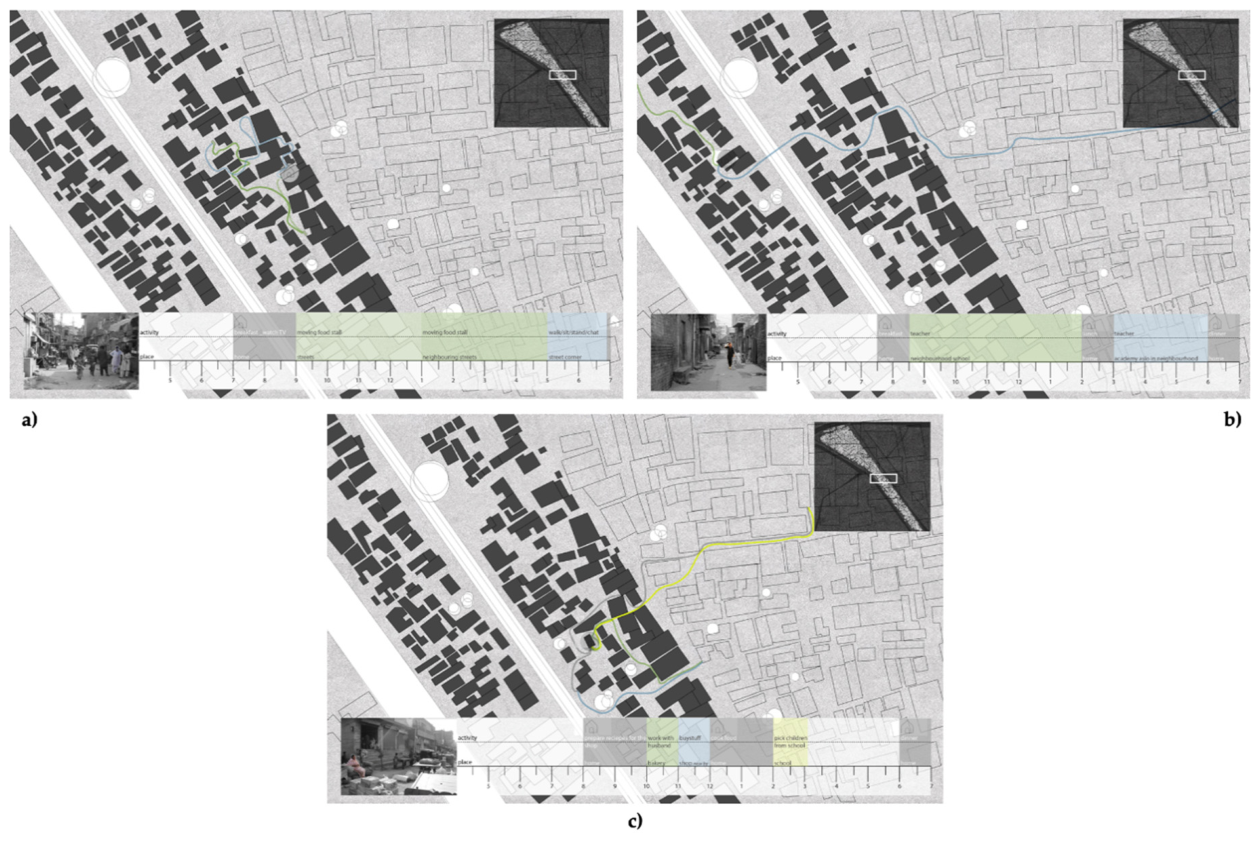
Figure 6.
Sectional representation of a resident’s daily activities across domestic, livelihood, shopping, childcare, and evening routines. Source: authors.
Figure 6.
Sectional representation of a resident’s daily activities across domestic, livelihood, shopping, childcare, and evening routines. Source: authors.
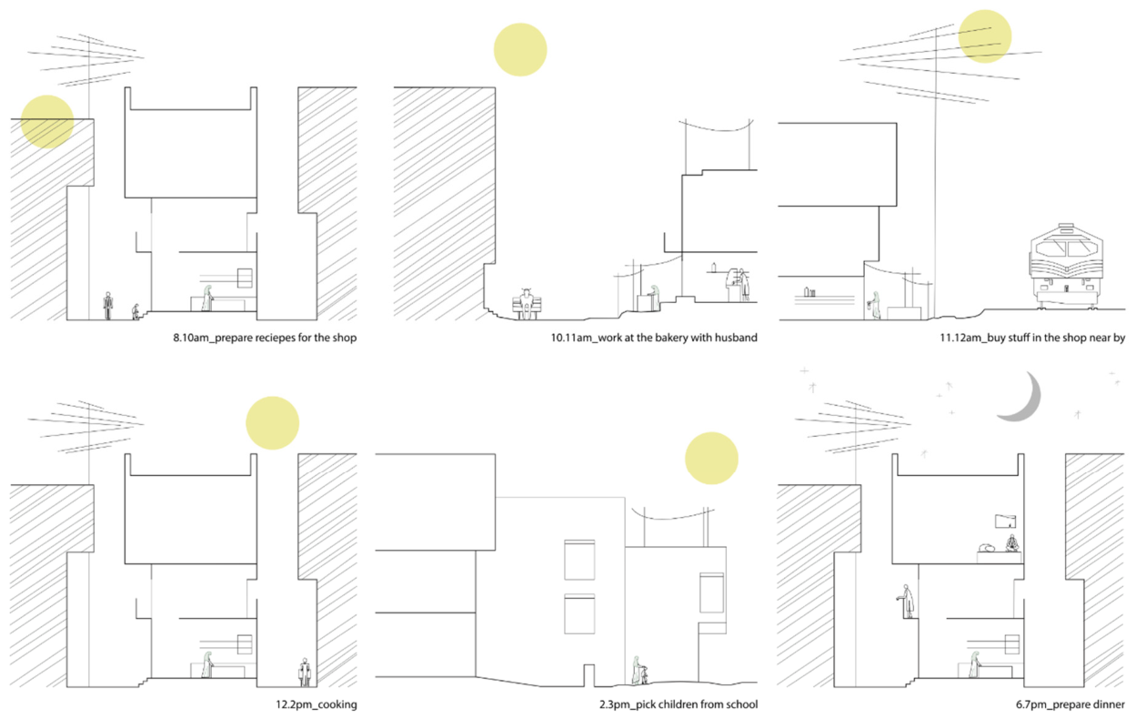
Figure 7.
Distribution of social-interaction concentrations and their relationship with land use, street connections, and activity nodes. Source: authors.
Figure 7.
Distribution of social-interaction concentrations and their relationship with land use, street connections, and activity nodes. Source: authors.
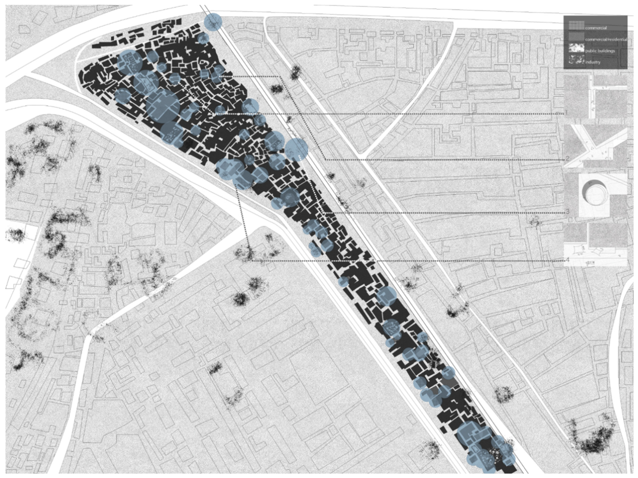
Figure 8.
Street morphology and building–street relationships: (a) street plan, (b) axonometric view, and (c) longitudinal and transverse sections. Source: authors.
Figure 8.
Street morphology and building–street relationships: (a) street plan, (b) axonometric view, and (c) longitudinal and transverse sections. Source: authors.
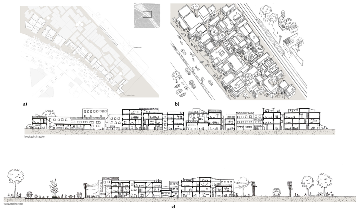
Figure 9.
Building section and elevation showing mixed use, rooftop activity, local construction, and utility conditions. Source: authors.
Figure 9.
Building section and elevation showing mixed use, rooftop activity, local construction, and utility conditions. Source: authors.
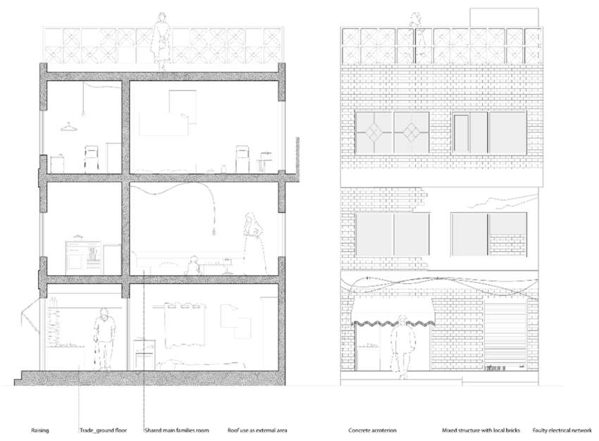
Figure 10.
Seasonal variation in temperature, rainfall, sunshine duration, and outdoor social interaction. Source: authors.
Figure 10.
Seasonal variation in temperature, rainfall, sunshine duration, and outdoor social interaction. Source: authors.
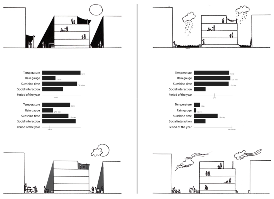
Figure 11.
Resident-led shading strategies and variations in solar exposure across internal lanes, commercial edges, and open spaces. Source: authors.
Figure 11.
Resident-led shading strategies and variations in solar exposure across internal lanes, commercial edges, and open spaces. Source: authors.
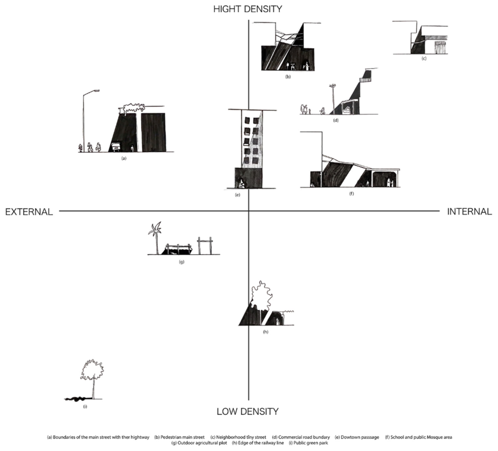
Figure 12.
Water-related environmental stress, including standing water, drainage failure, dampness, waste accumulation, and opportunities for planted water treatment. Source: authors.
Figure 12.
Water-related environmental stress, including standing water, drainage failure, dampness, waste accumulation, and opportunities for planted water treatment. Source: authors.
Disclaimer/Publisher’s Note: The statements, opinions and data contained in all publications are solely those of the individual author(s) and contributor(s) and not of MDPI and/or the editor(s). MDPI and/or the editor(s) disclaim responsibility for any injury to people or property resulting from any ideas, methods, instructions or products referred to in the content. |
© 2026 by the authors. Licensee MDPI, Basel, Switzerland. This article is an open access article distributed under the terms and conditions of the Creative Commons Attribution (CC BY) license (http://creativecommons.org/licenses/by/4.0/).
Copyright: This open access article is published under a Creative Commons CC BY 4.0 license, which permit the free download, distribution, and reuse, provided that the author and preprint are cited in any reuse.


