
Submitted:
10 July 2026
Posted:
14 July 2026
You are already at the latest version
Abstract
The threat of lightning to human society is increasingly severe, and the characteristics of the resulting casualties, along with their underlying mechanisms, have long been key topics in natural disaster research.Based on lightning disaster compilation data from 2000 to 2023, lightning monitoring data from 2009 to 2020, and multi-source data including soil resistivity, elevation and topographic relief in Zhaoqing, this paper statistically analyzes the distribution characteristics of lightning disasters in various districts of Zhaoqing from the perspectives of temporal occurrence, spatial distribution, casualties, disaster environments, hazard factors, and hazard-pregnant environmental characteristics. The results indicate that: (1) Lightning disasters have shown a decreasing trend since 2000.From 2000 to 2023, a total of 777 lightning disasters occurred in Zhaoqing, causing direct economic losses of approximately 22.6131 million yuan. (2) The monthly distribution of lightning disasters in Zhaoqing peaks mainly from April to September. The Fengkai-Huaiji area and the Sihui-Gaoyao area are high-incidence zones for lightning casualty accidents. (3) Farmlands, areas near buildings, and the interiors of buildings are high-risk environments for lightning casualties in Zhaoqing. Disasters occurring inside buildings result in the highest number of casualties. Lightning casualty accidents are primarily concentrated in rural areas or associated with agricultural activities. (4) Sihui, Duanzhou, and Dinghu rank top three in cloud-to-ground (CG) lightning density in the city. In terms of casualty density per unit area, Duanzhou, Dinghu, and Deqing are the highest. (5) The distribution characteristics of topographic relief and elevation show obvious commonalities, with high-value areas concentrated in the central, mid-western parts of Zhaoqing, and northern Huaiji, while low-value areas are mainly in the southeastern part of Zhaoqing.
Keywords:
klightning disaster
; lightning casualties
; multi-source data
1. Introduction
Lightning disasters are recognized by the United Nations as one of the “top ten most severe natural disasters”[1], characterized by instantaneous discharge, high voltage, strong current, and strong randomness, making them difficult to predict [2] . With the rapid development of social economy and electronic information technology, the casualties and property losses caused by lightning strikes have been increasing significantly.
Since the 20th century, the spatiotemporal distribution characteristics and hazard factors of lightning disasters have attracted considerable attention from researchers. The characteristics of lightning disasters in China are that they are primarily concentrated in the southern and eastern coastal regions, with obvious industry-specific vulnerabilities[3]. The national annual average number of lightning-induced deaths and casualty density also exhibited this pattern.[4]. Other researchers have characterized lightning casualties in terms of the perspectives of lightning activity variation, accident environments, and casualty demographics[5,6]. The results show that the temporal distribution characteristics of lightning disasters are related to changes in lightning activity and the work-rest schedules of outdoor workers. Among the environments where lightning accidents cause casualties, farmland accounts for the highest proportion, while group casualty events mainly occur near large trees and inside buildings without lightning protection systems. Lightning activity in the Nanning region plays a dominant role in triggering local disasters[7]. Based on lightning disaster census data for Foshan City, researchers integrated multiple evaluation indicators with GIS techniques to generate a spatial distribution map of lightning disasters.[8]. Some scholars have also analyzed regional lightning disaster characteristics through vulnerability assessments and risk zoning[9,10,11] .
Zhaoqing is a high-incidence area for severe lightning activity. As the gateway of the Guangdong-Hong Kong-Macao Greater Bay Area to the southwestern region of China, the city suffers huge casualties and economic losses due to lightning disasters every year[12,13]. Currently, statistical analyses of lightning disasters in Zhaoqing remain insufficient. This paper utilizes multi-source data, including lightning disaster records, lightning monitoring data, soil resistivity, elevation, and topographic relief, to study the characteristics of lightning disasters across Zhaoqing, revealing the spatiotemporal patterns, casualties, casualty environments, spatiotemporal distribution characteristics of hazard factors, and hazard-pregnant environmental characteristics, thereby providing a scientific basis for strengthening lightning disaster prevention and mitigation efforts in Zhaoqing.
The remainder of this paper is organized as follows. Section 2 briefly describes the data sources and processing methods. Section 3 analyzes the characteristics of lightning disasters in Zhaoqing City,Guangdong Province, China, summarizes the statistics of lightning disaster incidents, examines the temporal and spatial distribution of lightning disasters, and presents a classified statistical analysis of the environments in which lightning-induced casualties occurred. Section 4 analyzes the lightning hazard factor—cloud-to-ground lightning density. Section 5 introduces the environmental factors influencing lightning disaster formation in the Zhaoqing region, with a focus on evaluating altitude and terrain fluctuation indices and conducting risk zonation based on actual conditions. Section 6 presents the conclusions.
2. Data and Methodology
The historical lightning disaster data used in this paper are derived from the lightning disaster compilation of Guangdong Province from 2000 to 2023, covering a total of 24 years. The dataset contains detailed information including casualties, economic losses, and the background of lightning disaster events. Although some information is missing, it remains the most comprehensive official record currently available[14] .
The lightning location data used in this study is derived from the Guangdong Lightning Location System over a 12-year period from 2009 to 2020. This system, established in 1999, is one of the most advanced lightning location systems in China, providing reliable retrievals of cloud-to-ground (CG) lightning, return strokes, location accuracy, and peak current intensity. It can monitor data elements such as lightning location, occurrence time, and current amplitude.
The geographic information data include the Digital Elevation Model (DEM) data of Zhaoqing, topographic relief, and measured soil resistivity. Topographic data were normalized, and the standard deviation of elevation within a 1 km × 1 km window centered on each target grid cell was calculated to generate normalized raster data.
3. Results
3.1. Lightning Disaster Characteristics in Zhaoqing
3.1.1. Overall Situation
Over the 24-year period from 2000 to 2023, a total of 777 lightning disasters occurred in Zhaoqing, including 2 extraordinarily severe lightning disasters, 5 major lightning disasters, 34 moderately lightning disasters, and 736 general lightning disasters.
As shown in Figure 1 and Figure 2, from 2000 to 2023, the direct economic losses caused by lightning disasters in Zhaoqing amounted to approximately 22.6131 million yuan, with an annual average direct economic loss of 0.9422 million yuan. Indirect economic losses reached 67.4863 million yuan, with an annual average loss of approximately 2.8119 million yuan. A total of 325 household devices, 3,206 public devices and 57 buildings were damaged, with office electronic equipment accounting for more than 90% of the total damage incidents. Notably, in 2009, an extraordinarily severe lightning disaster occurred at the Zhenshan Broadcasting and Television Transmission Center of Sihui Radio and Television Station, resulting in damage to 278 electronic devices, with direct economic losses of approximately 6.75 million yuan and indirect economic losses of 12.6 million yuan.
3.1.2. Spatiotemporal Distribution Characteristics of Lightning Disasters
Monthly Distribution of Lightning Disasters
Figure 3 shows the monthly distribution of lightning disasters in Zhaoqing from 2000 to 2023. The figure indicates that the monthly distribution of lightning disasters in Zhaoqing is distinct, primarily concentrated from April to September, accounting for more than 90% of the annual total, with the peak occurring in June.This period coincides with the flood season in Guangdong, which consists of two rainy phases: the first rainy season from April to June and the second rainy season from July to September. During these phases, severe convective weather events frequently occur, including thunderstorms with strong winds, hail, and tornadoes. Among them, thunderstorms accompanied by strong winds are most common in spring, summer, and autumn.
Spatial Distribution of Lightning Casualties
Table 1 summarizes the lightning disaster casualties in various districts of Zhaoqing from 2000 to 2023. A total of 33 lightning casualty accidents occurred in Zhaoqing, resulting in 37 injuries and 36 deaths,with a death-to-injury ratio of 0.97, which is lower than the national statistical average (0.31) and that of economically underdeveloped regions such as Africa, but significantly higher than that of developed countries in Europe and America where the ratio is about 1:10[15,16,17,18,19,20,21].
Integrating the information from Figure 4 and Table 1, suggests that the factors contributing to lightning casualties in different districts of Zhaoqing are complex. Deqing County showed the most prominent lightning casualty situation, with 21 casualties over the past 24 years, accounting for 29% of the total casualties in the city. Fengkai County ranks second with 14 casualties. Huaiji County ranks third in terms of both the number of incidents and casualty counts. Guangning reports the lowest occurrence, with no lightning casualty events over the past 24 years. This indicates that the spatial distribution of lightning casualty events exhibits regional differences and randomness, with casualty accidents mainly occurring in the Deqing-Fengkai-Huaiji area and Sihui-Gaoyao area.
3.1.3. Analysis of Lightning Casualty Environment Characteristics
To better implement lightning disaster prevention and mitigation efforts in Zhaoqing, it is necessary to understand the environmental characteristics of locations where lightning casualties occur[22]. Figure 4 presents a comparative statistical distribution of different lightning strike environments. This paper categorizes the environments into six types: inside simple buildings (including simple houses without lightning protection facilities, pavilions, temporary shelters, and grass sheds), outside buildings (including under eaves, building rooftops, areas near buildings, livestock enclosures, and playgrounds), farmlands (non-paddy fields), near water bodies, paddy fields and ponds (including paddy fields, fish and shrimp ponds, etc.), and near large trees.
As shown in Table 2 and Figure 4, the highest number of lightning casualty events and casualties in Zhaoqing from 2000 to 2023 occurred in farmlands. Paddy fields and ponds are also high-incidence areas for lightning casualty events (17.65%). Notably, the number of casualties inside simple buildings (15) ranks second, slightly lower than that in farmlands[23]. Most of these cases were caused by people taking shelter from rain in wind and rain pavilions or working in temporary shelters during thunderstorms. The environment with the highest ratio of casualties to events is near large trees (4.00), where casualties are often caused by lightning strikes affecting groups of people sheltering under trees[24].
Lightning casualty accidents primarily occur in rural areas or are associated with agricultural activities. Casualties in farmlands[25,26,27,28], paddy fields/ponds, and near water bodies account for 64.7% of the total. The peak season for lightning activity coincides with the busy agricultural season. Rural areas lack adequate lightning protection measures, and farmers have difficulty taking shelter in time when thunderstorms occur, making them vulnerable to lightning strike casualties.
3.2. Analysis of Lightning Hazard Factors
3.2.1. Temporal Distribution Characteristics of CG Lightning Frequency
CG lightning activity is the source of lightning disasters, also referred to as the hazard factor. Generally, the higher the density and frequency of hazard factors, the greater the probability of lightning disasters and the more severe the resulting damage.
Figure 5 shows the monthly distribution of CG lightning frequency in Zhaoqing. Lightning activity in Zhaoqing is mainly concentrated from April to September, which is consistent with the monthly distribution of lightning disasters, with the peak occurring in June.
According to the daily distribution statistics of CG lightning frequency in Zhaoqing, a single-peak pattern is observed within a day, with a high-frequency period occurring from afternoon to early evening (13:00–19:00 LST). The peak lightning occurrence within a day is observed around 16:00 LST.
3.2.2. Correlation Analysis Between CG Lightning Density and Lightning Disasters
CG lightning density is an important indicator of the hazard environment in a region and is generally positively correlated with the probability of lightning disasters (unit: times/(km²·year)). Based on the monitoring data from the Guangdong Lightning Location System, the region was grided in the resolution of 1 km × 1 km, and the CG lightning density of each grid point was calculated.
As shown in Figure 6, Sihui, Duanzhou, and Dinghu rank top three in annual average CG lightning density in the city. In terms of lightning casualty density (accounting for area weight), Duanzhou, Dinghu, and Deqing are the highest. These four districts experience frequent lightning activity and have high population densities, resulting in higher lightning casualty densities[29,30].The CG lightning density in Gaoyao (29.58 times/(km²·year)) is 1.37 times and 1.35 times that of Fengkai (21.58times/(km²·year))and Huaiji (21.84 times/(km²·year)),respectively. However, the lightning casualty density in Gaoyao is comparable to that in Huaiji and only about 50% of that in Fengkai. After accounting for area weight, the correlation between lightning casualty event density and CG lightning density in Zhaoqing is not particularly significant[31], with a correlation coefficient of only 0.34. This may be attributed to differences in economic development levels and topographic features. Gaoyao is located in the hinterland of Zhaoqing urban area with relatively flat terrain, a higher level of urbanization, and a lower proportion of agricultural population. Additionally, local governments have invested significantly in disaster prevention and mitigation as well as lightning warning efforts, resulting in a lower casualty density. In contrast, Fengkai and Huaiji are located in the western and northern parts of Zhaoqing, with relatively less developed economies. These areas are predominantly hilly and mountainous, with more agricultural activities in mountainous regions and relatively concentrated residential populations, leading to more lightning casualties. Therefore, the causes of lightning disasters are complex, relating not only to hazard factors but also significantly to the hazard-pregnant environment.
3.3. Analysis and Assessment of Lightning Hazard-Pregnant Environment
The influencing factors of the hazard-pregnant environment include soil resistivity, elevation, and topographic relief index. As indicated by the previous analysis, lightning disaster risk is not only related to hazard factors but also to the hazard-pregnant environment.
3.3.1. Soil Resistivity
Based on available data, a correlation analysis between soil texture and soil conductivity in Zhaoqing was conducted to generate raster data of soil resistivity in Zhaoqing and complete the normalized hazard statistics of soil resistivity. Soil resistivity is generally high across Zhaoqing, except for a small area in southern Gaoyao and along the southern edge of Deqing, where it is relatively low. Overall, the differences are not substantial, and the reference value for assessing lightning disaster hazard is relatively low.
3.3.2. Elevation
The Digital Elevation Model (DEM) data of Zhaoqing were used to generate a normalized map of altitude indicator values for Zhaoqing. Figure 7 shows obvious regional differences in altitude in Zhaoqing. High-level areas are concentrated in the central, mid-western, and northern parts of the city, while the southeastern part of Zhaoqing (Duanzhou, Dinghu, and Sihui) and areas along the margins have relatively low altitudes.
3.3.3. Topographic Relief
Topographic data were utilized to generate normalized raster data, producing a topographic relief distribution map of Zhaoqing (Figure 8). A comparison reveals obvious commonalities in the distribution characteristics of topographic relief and elevation in Zhaoqing. High-value areas are concentrated in the central and mid-western parts of Zhaoqing as well as the northern part of Huaiji County, while low-value areas are mainly located in the southeastern part of Zhaoqing. However, in the southeastern part of Huaiji County, the terrain is relatively gentle while the elevation level is high, indicating a lack of correlation between the two factors.
4. Discussion
This study conducts a comprehensive analysis of the characteristics and formation mechanisms of lightning-induced disasters in Zhaoqing City based on multi-source data. By comparing the results with those from other regions in China, the understanding of Zhaoqing’s regional particularities is deepened.
4.1. Characteristics of Disaster Losses
During 2000–2023, a total of 777 lightning-induced disaster events were recorded in Zhaoqing, causing direct economic losses of 22.6131 million CNY, with a fluctuating upward trend. This is consistent with the overall increasing trend of economic losses from lightning disasters observed in Guangdong Province and the Pearl River Delta (PRD) region,China reflecting a common regional pattern [6,8,32,33]. However, compared with highly urbanized PRD megacities [32,33], Zhaoqing exhibits relatively lower economic losses per unit area. Nevertheless, the proportion of damaged electronic and electrical equipment (>90%) is comparable to that reported in Jiangsu Province, China, in 2023 [34], and aligns closely with the loss characteristics of most affected areas across in Guangdong Province and even most regions of China. This highlights the large stock of precision equipment in modern society and the vulnerability of economic systems to lightning electromagnetic pulses [4]. Notably, major lightning disaster cases in Zhaoqing (e.g., the 2009 Sihui TV station incident) underscore the critical role of specific key protected facilities in regional risk, an aspect less frequently addressed in studies focusing on large public infrastructure.
4.2. Spatiotemporal Patterns
Lightning disasters in Zhaoqing are concentrated in the period from April to September and from afternoon to dusk, which is in agreement with the temporal distribution of lightning disasters and lightning activity in South China and most parts of the country, reflecting the joint control of large-scale weather systems and diurnal solar radiation variations [3]. Spatially, Zhaoqing presents a composite pattern: high total casualties in the northwestern mountainous areas and high casualty density in the central urban district. This pattern partially matches the findings in the PRD core area , where high casualty density heavily overlaps with high population density and high economic activity zones [8], but adds an additional dimension of mountainous risk. Similar high casualty occurrences in the northwestern mountains of Zhaoqing have also been reported in studies of mountainous provinces in China [35,36], with commonalities including complex terrain and high exposure of the agricultural population. Our quantitative analysis reveals a weak correlation between cloud-to-ground (CG) lightning flash density and casualty density in Zhaoqing (r = 0.34), which is similar to the general conclusion for Guangdong Province [14] but differs from some studies in plain regions where lightning activity dominates the risk. This disparity emphasizes that in regions with diversified terrain and economic structures like Zhaoqing, the weights of hazard-prone environment and exposure factors in risk formation are substantially increased, validating the necessity of “tailored” risk assessments.
4.3. Risk Formation Mechanisms
This study proposes that the lightning disaster risk in Zhaoqing is the result of a coupled “sky-earth-human” mechanism. This framework is consistent with the prevailing paradigm of disaster risk research (hazard-exposure-vulnerability). The fundamental role of the “sky” (hazard factor) is universal. Regarding the amplifying effect of the “earth” (hazard-prone environment), our study confirms that complex terrain (high elevation and high relief) not only potentially influences lightning activity—as elevation has been shown to significantly affect CG flash activity [37]—but also critically amplifies personnel exposure risk by limiting sheltering options. This effect is not significant in studies of pure plains, but corroborates findings in hilly and mountainous areas [38,39,40], where terrain elevation, slope, and aspect significantly affect the spatial distribution of lightning disasters, with hills identified as the highest-risk zones; in Fujian,China, high lightning disaster incidence occurs on both sides of the Yingfeng and Daiyun Mountains. Thus, terrain factors are indispensable in lightning risk assessment for mountainous regions. At the “human” (exposure/vulnerability) level, the high vulnerability of rural and agricultural activities is a core feature of lightning casualties in Zhaoqing, which shares a prominent commonality with multiple provinces in China as a whole—lightning casualties are more frequent in rural than in urban areas [4,14,41,42]. Our study further refines two extremely high-risk micro-environments: “inside simple structures” and “beside large trees.” The former is consistent with the finding in Guangdong that “inside buildings without lightning protection systems” is a major cause of group casualties [14], while the latter is a long-standing widespread pain point in rural lightning casualty events across China. Compared with the PRD core area, the risk in Zhaoqing’s central urban district is mainly driven by high exposure rather than extremely weak physical protection, reflecting structural differences in vulnerability of hazard-bearing bodies at different development stages within the region.
4.4. High-Risk Environments
Farmland, inside simple structures, and beside large trees are the three major high-risk environments in Zhaoqing. This finding is highly consistent with the lightning casualty environmental characteristics reported in Guangdong and many agricultural provinces , where the majority of lightning casualties occur in rural areas, and farmlands and (simple) structures are the most frequent sites, often lacking necessary shelter [43,44,45,46]. These results indicate that the hazardous nature of such environments is a cross-regional universal pattern. Notably, Zhaoqing shows a high casualty-to-event ratio (3.0) for “inside simple structures,” which is consistent with the Guangdong focus on group casualties “inside buildings” but more precisely points to “simple” structures that have virtually no lightning protection measures, offering more targeted guidance for protective interventions. The high group casualty ratio (4.0) for “beside large trees” is a nationwide phenomenon, highlighting the long-term importance of public education on lightning safety knowledge.
It should be noted that the disaster data used in this study may contain underreporting, especially for small-loss events in remote rural areas. The lightning location system data (2009–2020) do not fully overlap temporally with the disaster data (2000–2023), which may cause minor impacts on the precision of spatiotemporal matching analyses. The quantification of exposure and vulnerability (e.g., the rate of buildings equipped with lightning protection devices, demographic age structure, disaster awareness, etc.) can be further deepened. Future work should integrate higher-spatiotemporal-resolution data, quantify the contribution weights of each influencing factor, and strengthen dynamic vulnerability assessments.
5. Conclusions
Based on historical lightning disaster compilation data and lightning monitoring data in Zhaoqing, this paper statistically analyzes the distribution characteristics of lightning disasters in various districts of Zhaoqing from the perspectives of temporal occurrence, spatial distribution, casualties, and disaster environments. The following conclusions are drawn:
(1)From 2000 to 2023, a total of 777 lightning disasters occurred in Zhaoqing, including 2 extraordinarily severe lightning disasters, 5 major lightning disasters, and 34 moderately lightning disasters.The monthly distribution of lightning disasters in Zhaoqing peaks mainly from April to September, accounting for 93.06% of the annual total. The high-incidence period of lightning activity is consistent with the monthly distribution of lightning disasters. The high-frequency period for daily lightning distribution is from afternoon to evening (13:00–19:00 LST).
(2)The spatial distribution of lightning casualty events exhibits obvious regional characteristics, mainly occurring in the Fengkai-Huaiji area and the Sihui-Gaoyao area. The casualty density and CG lightning density in Duanzhou, Dinghu, and Sihui generally show a good correspondence. The causes of lightning disasters are complex, relating not only to hazard factors but also significantly to the hazard-pregnant environment.
(3)Analysis of lightning casualty environments reveals that farmlands, areas near buildings, and the interiors of buildings are high-risk areas for lightning casualties. Disasters occurring inside buildings result in the highest number of casualties. The environment with the highest ratio of casualties to events is near large trees. Lightning casualty accidents are primarily concentrated in rural areas or associated with agricultural activities.
(4)Among the influencing factors of the hazard-pregnant environment in Zhaoqing, soil resistivity has a relatively low reference value for assessing lightning disaster hazard. The distribution characteristics of topographic relief and evelation show obvious commonalities, with high-value areas concentrated in the central, mid-western parts of Zhaoqing, and northern Huaiji, while low-value areas are mainly in the southeastern part of Zhaoqing.
Author Contributions
Conceptualization, C.H. ; methodology, C.H.; software, C.C.; validation, C.H.; formal analysis, X.H.; investigation, C.H.; resources, C.C.; data curation, C.C.; writing—original draft preparation, C.H.; writing—review and editing, C.C.; visualization, X.H.; supervision, C.C.; project administration, X.H.; funding acquisition, , C.H. All authors have read and agreed to the published version of the manuscript.
Funding
This research was funded by the Science and Technology Project of the Guangdong Meteorological Bureau, grant number MS202346. The contents of this publication are solely the responsibility of the author.
Institutional Review Board Statement
Not applicable
Informed Consent Statement
Not applicable.
Data Availability Statement
Lightning disaster data were compiled from the 24-year lightning disaster archives (2000–2023) organized by the meteorological department of Guangdong Province. Cloud-to-ground lightning observation data covering 12 years (2009–2020) were obtained from the Guangdong Lightning Location System.Digital Elevation Model (DEM) data were downloaded from the Geospatial Data Cloud (https://www.gscloud.cn).Field-measured soil resistivity data for Zhaoqing were provided by the Zhaoqing Meteorological Bureau.Basic geospatial datasets, including administrative divisions, land use types and population distribution of Zhaoqing City, were derived from publicly available data released by China’s statistical authorities.
Acknowledgments
The authors would like to thank all individuals who contributed indirectly to
this work. In this section, you can acknowledge any support given which is not covered by the author contribution or funding sections. This may include administrative and technical support, or donations in kind (e.g., materials used for experiments). Where GenAI has been used for purposes such as generating text, data, or graphics, or for study design, data collection, analysis, or interpretation of data, please add “During the preparation of this manuscript/study, the author(s) used [tool name, version information] for the purposes of [description of use]. The authors have reviewed and edited the output and take full responsibility for the content of this publication.”
Conflicts of Interest
The authors declare no conflicts of interest.
Abbreviations
The following abbreviations are used in this manuscript:
| CG | Cloud-to-ground |
| LST | Local Standard Time |
| DEM | Digital Elevation Model |
References
- Chen, W.M. Principles of Lightning; China Meteorological Press: Beijing, China, 2003; p. 297. [Google Scholar]
- Yang, S.G.; Zhao, G.X.; Pan, S.; Niu, Y.B.; Hu, J.J.; Wang, C.Y.; Gao, X.L.; Zhang, W.M. Temporal and Spatial Distribution Characteristics and Early Warning of Lightning Disasters in China. J. Nat. Disasters 2010, 19(6), 153–159. [Google Scholar] [CrossRef]
- Liu, J.; Xiao, W.A.; Chen, H.B. Analysis of National Lightning Disasters and Prediction of Lightning Disaster Economic Losses. Meteorol. Environ. Sci. 2010, 4, 21–26. [Google Scholar] [CrossRef]
- Gao, Y.; Zhang, Y.J.; Zhang, W.J.; Zhang, Y. Characteristics of Lightning Casualties and Vulnerability Assessment Zoning in China. J. Appl. Meteorol. Sci. 2012, 23(3), 294–303. [Google Scholar] [CrossRef]
- Zhang, W.J.; Meng, Q.; Ma, M.; Zhang, Y.J. Lightning Casualties and Damages in China from 1997 to 2009. Nat. Hazards 2011, 57(2), 465–476. [Google Scholar] [CrossRef]
- Yin, Q.Y.; Guo, Z.Y.; Zhang, Y.J.; Zhuang, Y.X.; Chen, L.W. Characteristics of Lightning Casualties in Guangdong from 1995 to 2018. J. Trop. Meteorol. 2021, 37(3), 512–520. [Google Scholar] [CrossRef]
- Chen, X.Y.; Kang, Q.; Zhi, Y.L. Analysis of Lightning Disaster Characteristics in Nanning from 1998 to 2019. Meteorol. Res. Appl. 2020, 41(1), 21–25. [Google Scholar] [CrossRef]
- Zeng, Y.; Gu, B.H.; Wan, J.; Yin, Q.Y.; Chen, J.R.; Wang, Y.Z. Analysis of Lightning Disaster Casualties and Risk Zoning in Foshan City. Guangdong Meteorol. 2022, 44(4), 66–69. [Google Scholar] [CrossRef]
- Lyu, H.Y.; Li, W.F.; Wu, J. Statistical Analysis of Lightning Disaster Accidents in Guangdong Province from 1995 to 2014. Guangdong Meteorol. 2016, 37(6), 52–55. [Google Scholar] [CrossRef]
- Cui, X.; Zhuang, Y.X.; Wang, H.S. Lightning Disaster Risk Zoning in Jiangsu Province Based on a Combined Evaluation Method. J. Nat. Disasters 2015, 24(6), 187–194. [Google Scholar] [CrossRef]
- Li, H.; Bian, W.X. Vulnerability Analysis and Risk Zoning of Lightning Disasters in Zhejiang Province. J. Nanjing Univ. Inf. Sci. Technol. 2014, 6(4), 336–341. [Google Scholar] [CrossRef]
- Zhao, X.; Zhao, Y.Y.; Li, F.J.; Pei, S.H.; Wang, Y.X. Characteristics of Lightning Activity in Zhaoqing City. Guangdong Meteorol. 2019, 41(5), 66–68. [Google Scholar] [CrossRef]
- Liu, S.M.; Hu, R.J.; Zeng, Y.B.; Xu, W. Analysis of Lightning Activity Characteristics and Lightning Disaster Losses in Guangdong Province in 2012. Guangdong Meteorol. 2012, 35(5), 46–48. [Google Scholar] [CrossRef]
- Yin, Q.Y.; Fan, X.P.; Chen, L.W.; Huang, X.X.; Zhuang, Y.X.; Zhang, Y.J. Characteristic Analysis of Lightning Casualty Accidents in Guangdong Province. J. Nat. Disasters 2019, 28(6), 204–213. [Google Scholar] [CrossRef]
- Holle, R.L. Lightning-Caused Deaths and Injuries Related to Agriculture. In Proceedings of the 24th International Lightning Detection Conference & 6th International Lightning Meteorology Conference, San Diego, CA, USA, 2016; pp. 1–5. Available online: https://www.vaisala.com/sites/default/files/documents/Ron%20Holle.%20Lightning-caused%20Deaths%20and%20Injuries.pdf.
- Borgerhoff Mulder, M.; Msalu, L.; Caro, T.; Salerno, J. Remarkable Rates of Lightning Strike Mortality in Malawi. PLoS ONE 2012, 7(1), e29281. [Google Scholar] [CrossRef] [PubMed]
- Kompacher, M.; Kindermann, G.; Pack, S. Fire Losses and Human Accidents Caused by Lightning—An Austrian Overview. In Proceedings of the 2012 International Conference on Lightning Protection, IEEE, Vienna, Austria, 2012. [Google Scholar] [CrossRef]
- Peppas, G.D.; Bekas, K.I.; Naxakis, I.A.; Pyrgioti, E.C.; Charalampakos, V.P. Analysis of Lightning Impacts in Greece. In Proceedings of the 2012 International Conference on Lightning Protection, IEEE, Vienna, Austria, 2012. [Google Scholar] [CrossRef]
- Elsom, D.M.; Webb, J.D.C. Deaths and Injuries from Lightning in the UK, 1988–2012. Weather 2014, 69, 221–226. [Google Scholar] [CrossRef]
- Tilev-Tanriover, Ş.; Kahraman, A.; Kadioğlu, M.; Schultz, D.M. Lightning Fatalities and Injuries in Turkey. Nat. Hazards Earth Syst. Sci. 2015, 15(8), 1881–1888. [Google Scholar] [CrossRef]
- Badoux, A.; Andres, N.; Techel, F.; Hegg, C. Natural Hazard Fatalities in Switzerland from 1946 to 2015. Nat. Hazards Earth Syst. Sci. 2016, 16(12), 1–41. [Google Scholar] [CrossRef]
- Curran, E.B.; Holle, R.L.; López, E.R. Lightning Casualties and Damages in the United States from 1959 to 1994. J. Clim. 2000, 13(19), 3448–3464. [Google Scholar] [CrossRef]
- Cooper, M.A.; Holle, R.L.; Andrews, C.J. Distribution of Lightning Injury Mechanisms. In Proceedings of the 2010 International Conference on Lightning Protection, IEEE, Cagliari, Italy. [CrossRef]
- Fan, X.P.; Zhang, Y.J.; Yin, Q.Y.; Zhang, Y.; Zheng, D. Characteristics of Multi-Stroke Lightning Related to Lightning Occurrence and Agriculture in Bangladesh. Int. J. Disaster Risk Reduct. 2019, 41, 1425–1442. [Google Scholar] [CrossRef]
- Illiyas, F.T.; Mohan, K.; Mani, S.K.; Pradeepkumar, A.P. Lightning Risk in India: Challenges in Disaster Compensation. Econ. Polit. Wkly. 2014, 49(23), 23–27. Available online: https://www.jstor.org/stable/24479604.
- Dewan, A.; Hossain, M.F.; Rahman, M.M.; Yamane, Y.; Holle, R.L. Recent Lightning-Related Fatalities and Injuries in Bangladesh. Weather Clim. Soc. 2017, 9(3), 575–589. [Google Scholar] [CrossRef]
- Dlamini, W.M. Lightning Fatalities in Swaziland: 2000–2007. Nat. Hazards 2009, 50(1), 179–191. [Google Scholar] [CrossRef]
- Holle, R.L.; Dewan, A.; Said, R.; Brooks, W.A.; Rafiuddin, M. Fatalities Related to Lightning Occurrence and Agriculture in Bangladesh. Int. J. Disaster Risk Reduct. 2019, 41, 101264. [Google Scholar] [CrossRef]
- Holle, R.L. A Summary of Recent National-Scale Lightning Fatality Studies. Weather Clim. Soc. 2015, 8(1), 35–42. [Google Scholar] [CrossRef]
- Navarrete-Aldana, N.; Cooper, M.A.; Holle, R.L. Lightning Fatalities in Colombia from 2000 to 2009. In Proceedings of the 2014 International Conference on Lightning Protection; IEEE. [CrossRef]
- Wang, P.; Zhang, T.; Tengge, E.W.; Zhang, X. Influence of Lightning Disaster on Cities and Lightning Defense Measures. Meteorol. Environ. Res. 2024, 15(3), 65–67. [Google Scholar] [CrossRef]
- Guo, X.F.; Zhang, C.F.; Lai, H.Y.; Zhao, M.J.; Hao, J.H.; Luo, H.Y. Research on Lightning Disaster Risk Zoning in Shenzhen from 2010 to 2019. Comput. Digit. Eng. 2022, 50(9), 2018–2024. [Google Scholar] [CrossRef]
- Zhang, C.Y.; Zhong, B.H.; Zhang, Y.F. Vulnerability Analysis and Vulnerability Zoning of Lightning Disasters in Guangzhou City. Shaanxi Meteorol. 2017, 6, 23–28. [Google Scholar] [CrossRef]
- Cui, X.; Liu, X.; Xu, Q.C.; et al. Comparative Analysis of Lightning Weather and Historical Lightning Disasters in Jiangsu Province in 2023. J. Agric. Disaster Res. 2025, 15(8), 82–84. [Google Scholar] [CrossRef]
- Liu, P.Y.; Yang, Z.K.; Hu, Y.; et al. Correlation Analysis of Lightning Disaster Distribution and Disaster-Causing Factors in Yunnan Province in 2016. J. Catastrophol. 2018, 33(1), 130–135, 151. [Google Scholar] [CrossRef]
- Peng, Q.Y.; Xiong, C.Z. Occurrence Regularity and Characteristic Analysis of Rural Lightning Disasters on Low-Latitude Plateau. J. Catastrophol. 2015, 30(4), 96–100. [Google Scholar] [CrossRef]
- Xu, J.Q.; Zhang, Y.; Fu, J.R.; Cai, Q. Influence of Topography on CG Lightning Activity in Guangdong Province. Guangdong Meteorol. 2024, 46(1), 63–67. [Google Scholar] [CrossRef]
- Zhu, H.; Cheng, X.Y.; Tian, H.; et al. Risk Assessment and Zoning of Lightning Disasters in Anhui Province Based on GIS. Torrential Rain Disasters 2024, 43(6), 733–740. [Google Scholar] [CrossRef]
- Liu, H.B.; Li, Y.T.; Liu, X.N.; et al. Effects of Different Underlying Surfaces on the Characteristics of Lightning Disasters in Jiangxi. Meteorol. Sci. Technol. 2026, 54(2), 309–320. [Google Scholar] [CrossRef]
- Lin, T.L.; Zeng, J.Q.; Wang, C.Y. Characteristic Analysis and Safety Protection of Lightning Disasters in Fujian Province. J. Fujian Radio TV Univ. 2007, 1, 78–80. [Google Scholar]
- He, C.X. Analysis on Frequent Occurrence Causes and Prevention Measures of Rural Lightning Disasters in Fujian. J. Agric. Disaster Res. 2024, 14(8), 302–304. [Google Scholar] [CrossRef]
- Chen, D.; Huang, M.L.; Zhu, Y. Characteristics and Causes of Rural Lightning Disasters in Guangxi: A Case Study of Binyang County. J. Meteorol. Res. Appl. 2020, 41(2), 97–100. [Google Scholar] [CrossRef]
- Lü, H.Y.; Li, W.F.; Wu, J. Statistical Analysis of Lightning Disaster Accidents in Guangdong Province from 1995 to 2014. Guangdong Meteorol. 2016, 37(6), 52–55. [Google Scholar] [CrossRef]
- He, Q.Y.; Liu, Y.Y.; Yang, J.Y.; et al. Analysis of Lightning Activity and Lightning Disaster Characteristics in Hunan Province. Adv. Meteorol. Sci. Technol. 2019, 9(6), 44–48. [Google Scholar] [CrossRef]
- Xia, X.; Jin, Y.G.; Duan, H.P.; et al. Spatial-Temporal Distribution Characteristics and Disaster Grade Division of Lightning Disasters and Lightning Activities in Jiangxi Province. J. Nat. Disasters 2022, 31(2), 252–260. [Google Scholar] [CrossRef]
- He, S.; Gong, M.X.; Le, H. Damage Characteristic Assessment of Lightning Disasters in Hubei Province. Adv. Meteorol. Sci. Technol. 2024, 14(4), 35–40. [Google Scholar] [CrossRef]
Figure 1.
Comparison of lightning disaster numbers in Zhaoqing from 2000 to 2023.
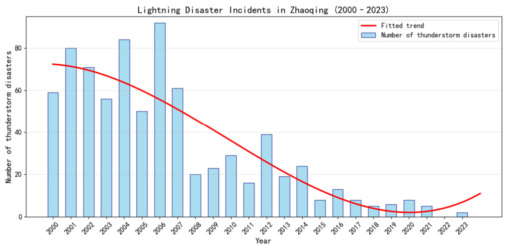
Figure 2.
Comparison of economic losses caused by lightning disasters in Zhaoqing from 2000 to 2023.
Figure 2.
Comparison of economic losses caused by lightning disasters in Zhaoqing from 2000 to 2023.
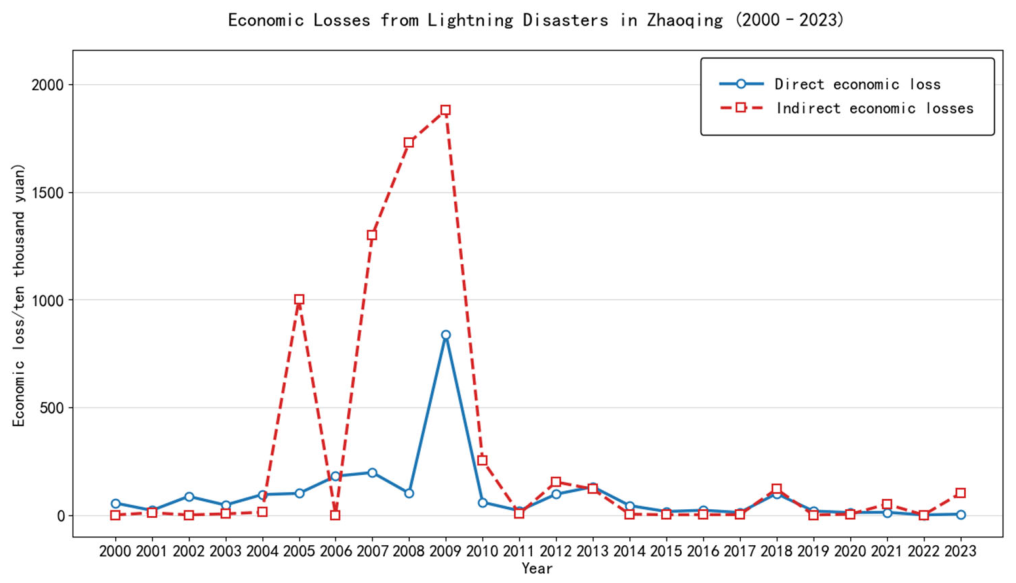
Figure 3.
Monthly distribution of lightning disasters in Zhaoqing from 2000 to 2023.
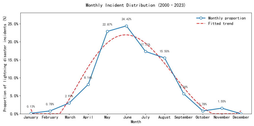
Figure 4.
Distribution of lightning casualty environments.
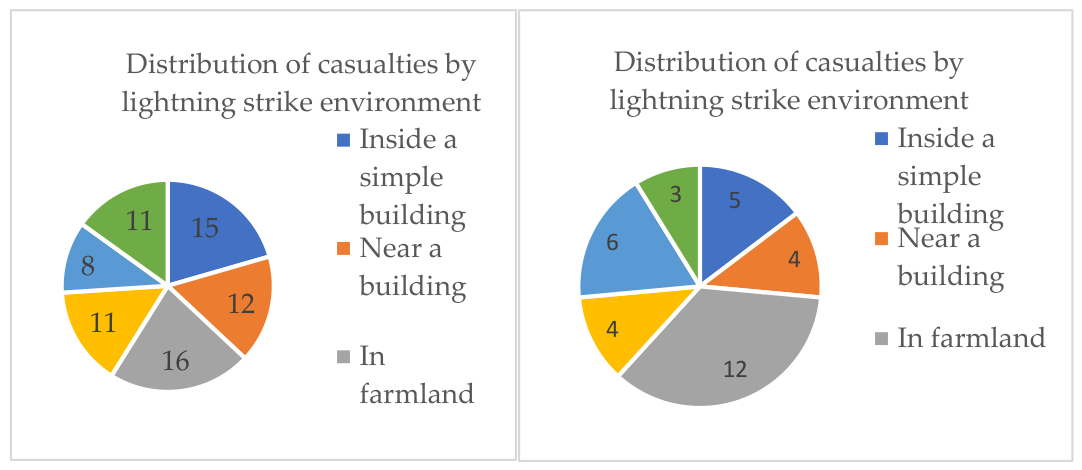
Figure 5.
Monthly distribution of CG lightning frequency in Zhaoqing.
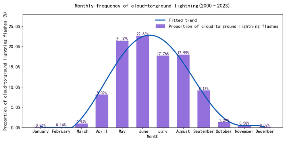
Figure 6.
Comparison of lightning casualty event density and CG lightning density.
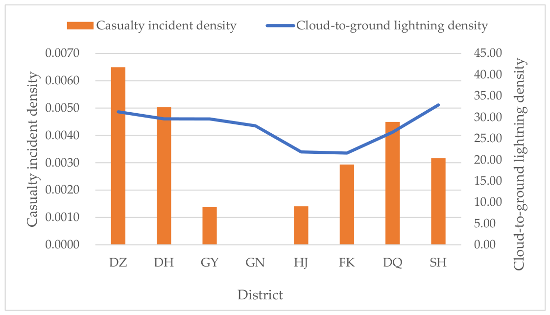
Figure 7.
Hazard distribution map of elevation in Zhaoqing.
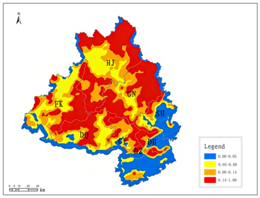
Figure 8.
Hazard distribution map of topographic relief in Zhaoqing.
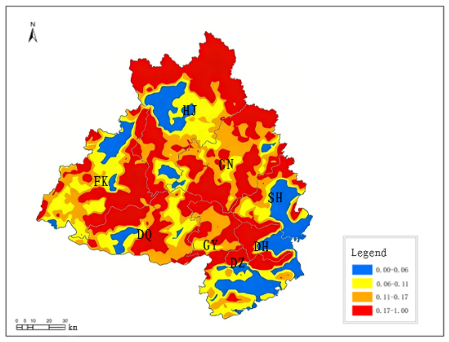

Table 1.
Lightning disaster records and related data for various districts of Zhaoqing.
| District | Totalcasualty events |
Casualties (persons) |
Annual injuries | Annual deaths |
Resident population (10⁴ persons) |
Land area (km²) |
Casualty event density (events/km²) |
| Duanzhou | 1 | 2 | 1 | 1 | 61.06 | 154 | 0.0065 |
| Dinghu | 3 | 6 | 3 | 3 | 20.91 | 596 | 0.0050 |
| Gaoyao | 3 | 8 | 2 | 6 | 74.16 | 2186 | 0.0014 |
| Guangning | 0 | 0 | 0 | 0 | 40.81 | 2455 | 0.0000 |
| Huaiji | 5 | 12 | 8 | 4 | 80.52 | 3554 | 0.0014 |
| Fengkai | 8 | 14 | 5 | 9 | 37.48 | 2724 | 0.0029 |
| Deqing | 9 | 21 | 12 | 9 | 33.14 | 2003 | 0.0045 |
| Sihui | 4 | 10 | 6 | 4 | 64.09 | 1264 | 0.0032 |
Table 2.
Distribution of casualties in different lightning strike environments.
| Inside simple buildings | Near buildings | Farmlands | Near water bodies | Paddy fields/ponds | Near large trees | |
| Number of events | 5 | 4 | 12 | 4 | 6 | 3 |
| Percentage of events (%) | 14.71 | 11.76 | 35.29 | 11.76 | 17.65 | 8.82 |
| Casualties (persons) | 15 | 12 | 16 | 11 | 8 | 11 |
| Percentage of casualties (%) | 20.55 | 16.44 | 21.92 | 15.07 | 10.96 | 15.07 |
| Casualties per event | 3.00 | 3.00 | 1.33 | 2.75 | 1.67 | 4.00 |
Disclaimer/Publisher’s Note: The statements, opinions and data contained in all publications are solely those of the individual author(s) and contributor(s) and not of MDPI and/or the editor(s). MDPI and/or the editor(s) disclaim responsibility for any injury to people or property resulting from any ideas, methods, instructions or products referred to in the content. |
© 2026 by the authors. Licensee MDPI, Basel, Switzerland. This article is an open access article distributed under the terms and conditions of the Creative Commons Attribution (CC BY) license (http://creativecommons.org/licenses/by/4.0/).
Copyright: This open access article is published under a Creative Commons CC BY 4.0 license, which permit the free download, distribution, and reuse, provided that the author and preprint are cited in any reuse.


