

Submitted:
04 July 2026
Posted:
06 July 2026
You are already at the latest version
Abstract
The Moroccan littoral stretches on 3,500 km, including 500 km on the Mediterranean side; this explains the considerable extent of the country’s coastal wetlands. The great variability in the geology and morphology of these littorals has led to a wide diversity of coastal landscapes, including more than 1,500 km of beaches and 1,000 km of rocky coastlines, interrupted by about 300 estuaries, and five large lagoons. This study aims to develop a primary classification of Morocco’s non-estuarine beaches, which number about 163 units. Referring to their descriptive inventory, based on four categories of physiographic criteria (morphology, geology, hydrodynamic, and sediments), we built a binary matrix 'beaches x criteria' that was treated using two statistical tools, k-means hierarchical clustering algorithm (HCA) and factorial correspondence analysis (CA). The main result of these treatments lies in a classification of the Moroccan non-estuarine beaches in fourteen clusters that can be explained by five determinant parameters: beach dimensions (width and length), slope, sediment grain size and spring tidal height. This classification could serve as a reference scheme for a more advanced classification of North African beaches, based on both satellite imagery and field measurements. With this in mind, the data collected in Morocco could serve as the basis for a larger database covering all North African coasts and built using the methodology presented in this article. In addition, this database would contribute significantly to the national inventory of wetlands, which is a fundamental step in their conservation.
Keywords:
non-estuarine beaches
; remote data
; multivariate methods
; morphodynamic classification
; Morocco
1. Introduction
Coastal zones are dynamic natural ecosystems whose formation and evolution are governed by both marine and terrestrial factors, which vary greatly in nature and scale. They offer great potential for human development (Farrell, 1986); their use, which dates back to ancient times, has intensified particularly over the past five decades, to the point of becoming one of the dominant factors in the evolution of the coastal landscape (Carter, 1980; Nordstrom & Arens, 1998; Jackson et al., 2013). This underscores the major challenges facing the preservation of coastal ecosystems in general and beaches in particular, challenges that are closely linked to the resilience of these ecosystems in the face of natural coastal dynamics and, above all, increasing anthropogenic pressures.
Beaches cover two-thirds of the total length of the world's coastlines (about 0.66%), excluding coastlines covered by ice. They are defined as accumulations of loose sediments deposited along the shoreline by waves, wind, and the erosion of coastal landforms; their grain size composition varies widely, ranging from silt to pebbles (Davis & FitzGerald, 2019; Short et al., 2001; Hobbs, 2012). The formation of beaches is primarily linked to the orohydrography of the coastline, while their functioning depends on the interplay of marine dynamics and various continental influences (Bird, 2010; Komar, 1998; Pinot, 1998; Doody, 2005; Graham, 2008), including human activities.
Due to its geographical location, straddling the Atlantic Ocean and the Mediterranean Sea, Morocco has a coastline stretching 3,500 km, including approximately 500 km of Mediterranean coastline; this explains the considerable extent of the country’s coastal wetlands (Dakki, 2022). The great variability in the geology and morphology of these coasts and their hinterlands has led to a wide diversity of coastal landscapes, including more than 1,500 km of beaches, some 1,000 km of rocky shores, over 300 river mouths, and five large lagoons (Dakki et al., 2020; Farhaoui et al., 2025). This highlights the great diversity of coastal habitats, particularly beaches, which translates into significant ecological, landscape and ecosystem service benefits. This richness has led to the designation of several coastal areas for conservation under various statuses, at both the national level (Sites of Biological and Ecological Interest, National Parks) and the international level (Ramsar Sites, Important Bird and Biodiversity Areas, Marine Protected Areas, Key Biodiversity Areas). This conservation requires in-depth knowledge of the functional characteristics of beaches, which can be captured through their inventory and classification, based on parameters that reveal their morphodynamic behaviour.
This study was conducted as part of a program of the inventory of Morocco’s coastal ecosystems; its initial findings were incorporated into an ecological classification of wetlands (Dakki 2022), which identified four major categories of coastlines. Furthermore, steep coasts were the subject of a more detailed classification (Farhaoui et al. 2025), based on physical criteria related to their local and hinterland environments.
The goal of this study is to develop a preliminary classification of all Mediterranean and Atlantic beaches of Morocco, based on a nearly exhaustive inventory of these beaches. The latter are described using morphological and hydrodynamic criteria that are relatively significant and easy to obtain through field measurements and, more particularly, satellite imagery. The classification is performed using multivariate methods, similar to those used for steep coasts (Farhaoui et al. 2025).
2. Materials and Methods
2.1. Preamble
A review of the techniques and criteria used in international and regional classifications (e.g., Wright and Short, 1984; Davies and Hayes, 1985; Masselink and Short, 1993; Burvingt et al., 2017, etc.) has revealed the dominant role of marine hydrodynamics (tides, swell, and waves). This offers various classification criteria, but predominantly of tides and waves, as well as wind (Micallef & Williams, 2004), and the degree of artificialisation (Roig-Munar et al., 2013). In parallel with this work, Williams et al. (2004) used approximately fifty physical, biological, and human criteria; however, their application proved to be complex and difficult to interpret (Micallef & Williams, 2004). However, the most widely used typologies were developed within the framework of general wetland classifications (e.g., Cowardin et al., 1979; Bissardon & Guibal, 1997) within hierarchically structured systems that were intuitively established.
Previous attempts to classify Moroccan beaches, primarily relying on ecological criteria (Bayed 2003; Bazairi et al., 2005; Chaouti et al., 2011), have drawn mainly on sediment grain size and living species. In this study, we attempted an initial physical typology of non-estuarine beaches of the country, combining morphodynamic and sedimentary criteria recognized for their relevance in previous studies (e.g., Anderson et al., 1976). However, the vast extent of the Moroccan coastline makes it difficult to monitor these parameters in the field; for this reason, we tested parameters derivable from satellite images (notably via the Google Earth platform), given that such an approach has yielded interesting results in the typology of estuarine areas (Al-Mahfadi et al. 2021) and steep coasts (Farhaoui et al. 2025). However, certain key criteria in beach classification (such as grain size) cannot be obtained through remote sensing, thus requiring a field survey, which also served to verify the data obtained remotely.
The data are organized into a ‘beaches x criteria’ matrix, which is processed using appropriate classification algorithms, based on multivariate techniques (Anderson et al., 1976; Gopal & Sah, 1995; Pittman et al., 2011; Alaoui et al., 2017; Al-Mahfadi et al., 2021). As these data are both qualitative and quantitative, the raw metric data are standardized by converting them into qualitative categories.
2.2. Identification, Delimitation, And Inventory of Beaches
Our classification is intended to be comprehensive, in the sense that it covers nearly all of Morocco’s beaches. We identified them primarily by examining satellite images of the coastline. Once identified, a beach is then designated by its central geographic coordinates, a code, and a name, the latter of which is determined using topographic or thematic maps or via Google’s My Maps browser.
Defining the beach boundary is crucial for measuring its local descriptors; this is done first by delineating its maximum extent on a high- or medium-resolution image, systematically referring to Google Earth and/or Landsat images (15- or 30-meter resolution (obtained at http://landsatlook.usgs.gov/viewer.htm) or Sentinel-2 images (https://dataspace. copernicus.eu/??). The lower and upper boundaries of the beach, coinciding with equinox tides or spring tides, are delineated on images (Figure 1); however, the upper boundary is sometimes defined using natural landmarks (limit of the terrestrial vegetation, steep terrain, etc.) or artificial obstacles (rocky shoals, embankments, walls, etc.).
2.3. Beach Classification Criteria and Techniques
To classify the beaches, we opted for two complementary multivariate approaches: Correspondence Factorial Analysis (CA) and Ascending Hierarchical Classification (AHC), which can organize the beaches into a hierarchical scheme based on a set of descriptors and a similarity metric. A total of 10 descriptors have been defined (Table 1), which are measurable either at the beach level (local criteria) or at the scale of the adjacent coastline (regional criteria).
2.3.1. Local Criteria
These criteria apply to the intertidal area, including its upper sandy border that may be reached by marine spray. We selected six criteria (Figure 2).
Width. This is the distance between the lowest-water and highest-water lines; it is measured at the widest part of the beach, which often corresponds to its midpoint; the measurement, taken on the beach’s boundary polygon, is then verified in the field using a tape measure.
Length. Measured along the shoreline at mean tide (mid-foreshore), it is often equated with the centreline connecting the ends of the beach.
Area. It is calculated from the beach boundary polygon.
Slope. It corresponds to the beach’s inclination, measured as the ratio of the elevation of its upper boundary (corresponding to the beach’s highest extent) to its width, as defined above; the elevation is estimated using Google Earth, then corrected on-site.
High tide amplitude. Across all natural beaches, tidal movements are one of the key hydrodynamic factors shaping their morphodynamic characteristics (Davis & Hayes, 1984b; Wright & Short, 1984; Eliot & Clarke, 1988; Masselink & Short, 1993; Bernabeu et al., 2003). This parameter, obtained at the website https://mareespeche.com/af/ marocco-atlantic, corresponds to the average height of the highest annual tides, calculated during the equinoxes (March and September), over the period 2010–2021.
Sediment grain size. It provides information on the genesis and dynamics of beaches, as well as on sediment transport from the mainland to the marine environment (Passega, 1963; Finkl, 2004). Data for this criterion were obtained through a sampling campaign that covered all the studied beaches; this campaign took place between June 1 and the end of September 2021. The grain size measurements, taken at low tide, were conducted on a small plot located near the centre of the beach, in the surface layer (approximately 20 cm thick), which corresponds to the beach’s “active layer.” Large grains (pebbles and stones) are measured on-site using a ruler; measurements are taken of the largest dimension of each item, and their average is taken as the size of these items. Pebbles smaller than 5–6 cm, gravel, and sand are brought back to the laboratory; samples are collected using a shovel over an area of 200 cm² (20 cm × 10 cm). The pebbles and gravel are then measured using a ruler, while the fine sediments (sand and silt) undergo a standard grain size analysis protocol. This involves drying the sediments in an oven at 105°C for 24 hours. Then, a 100-g sample is passed through a series of sieves with mesh sizes ranging from 0.063 μm to 2 mm, for 20 minutes of vibration at moderate speed (20 shakes per second). The material retained by the sieves is weighed, and a histogram of relative weights is generated. The criterion of interest to us is the mean grain size, obtained using the Folk & Ward (1957) method via the Gradistat application. It should be noted that the statistical approaches adopted for classifying grain size ranges do not require high data precision, since the data are converted into class values (categories).
2.3.2. Regional Criteria
These criteria apply to the littoral relief adjacent to the beach; they primarily concern geology, as the main factor shaping the coastline’s topography and the beach’s formation; however, this set of criteria will also include the potential influence of rivers at their mouths on the non-estuarine beaches, particularly on their sediments.
Distance from the beach to the nearest estuary. It is important to note in this regard that this study focuses on non-estuarine beaches; however, sediments transported by rivers toward the coast (Graham, 2008; Chauris, 1986) can be redirected toward coastal beaches by lateral ocean currents. The criterion under consideration is the probability that this influence is effective; this is roughly estimated by the distance between the midpoint of the beach and the centre of the nearest estuary. However, only the estuaries of large rivers, which transport large quantities of sediment, are considered.
Type of rocks predominant along the littoral. Expressed as a mineral component, this qualitative criterion required the classification of the rocks of the Moroccan coastline into three petrographic categories, specific to this study (Table 1). In practice, the coastal area presumed to influence the beach is roughly delineated, and its polygon is projected onto the geological map, where the rock categories are delineated. The value of this criterion then corresponds to the dominant surface category.
Age of the dominant petrographic unit. This refers to the geological era to which the dominant rock type belongs; for this purpose, we have identified four eras: Precambrian-Paleozoic, Mesozoic, Cenozoic, and Quaternary.
2.4. Statistical Analyses
To classify the beaches, we initially used correspondence analysis (CA), a method that has become widely used (Hill & Gauch, 1980; Lebreton et al., 1988; Bonin & Tatoni, 1990). This technique, which is primarily an ordination tool, is combined with Ward’s ascending hierarchical clustering method, which produces a tree structure of nested classes (Nakache & Confais, 2004).
Beaches are grouped iteratively according to their similarity, starting with the closest ones and gradually resulting in a dendrogram whose root groups all individuals together. In other words, similarities are calculated between individuals and then between increasingly heterogeneous groups.
3. Results
3.1. Beach Classification Drivers Identified by the CA
3.1.1. Decomposition of Total Inertia
Based on an estimate of the number of relevant dimensions to be interpreted, the analysis should be limited to a description of the first 20 dimensions. The inertia ratio of these components is higher than that of the 0.95 quantile of random distributions (92.15% versus 59.22%). Our analysis will be limited to these dimensions alone, which are rich in information (Figure 3)
The first two principal components explain only 21.93% of the overall variance (14.1% being attributable to the first component alone); thus, the F1×F2 plane accounts for just about one-fifth of the total variability of the point cloud. Additionally, the F3×F4 plane accounts for a larger share of the overall inertia (about one-third, i.e., 36.3%).
3.1.2. Explanatory Parameters for the First Four Pillars of the CA
The dispersion of the scatter plot in the two first planes (Figure 4) does not allow clearly defined clusters to be identified, although the density of points varies for each plane. However, these planes make it possible to identify the parameters that explain this dispersion, providing then a basis for the classification. To determine the beach descriptors likely to explain the similarities between beaches, we projected them onto the two planes, using their modalities as defined in Table 1 (Figure 5).
Axis 1 is strongly correlated (visually) with four local quantitative parameters reflecting the beaches' size (area, length, width) and their steepness (slope and height). These descriptors are indeed highly variable across space, particularly in relation to the orohydrographic configuration of the littoral. Two other parameters (tide amplitude and sediment size) help reveal differences along this axis.
Axis 2 is explained primarily by geological parameters, mainly the rock type, which distinguishes beaches on alluvial and conglomeratic terrains from other beaches; geological era accounts for the distinctiveness of beaches of Tertiary littorals. This dimension confirms the discriminatory role of regional geology in beach typology.
The F3×F4 plane (Figure 5) can be explained by five descriptors, four of which (area, length, width, and slope) already explain axis F1; this reinforces their role in this classification. On axis F3, the beaches with the smallest areas stand out from all other beaches, which are in turn scattered by axis F4. Width and slope primarily explain axis F3, while the beach length and the geology of littoral terrain contribute to axis F4. The other descriptors (beach height, distance to the nearest estuary, sediment size, and higher tides) have little contribution to this plane.
3.2. Coastal Sectors in the CA Classification
At the outset of the classification process, we divided the Moroccan littoral into eight sectors that are homogeneous in terms of physiography (Table 2), an arrangement that clearly results from the combined action of geology, climate, and marine hydrodynamics.
To determine whether the structure established by the CA reveals 'regional clusters', in the sense that beaches of the same sector belong to the same area of the CA planes, we visualized beaches of each sector on the CA's F1xF2 plot (Figure 6). Although no geographic location was used as a classification criterion, this approach highlights similarities between beaches within the same sector and more or less marked differences between sectors. This confirms the physiographic homogeneity of the different sectors, which had already been intuitively used to delineate them.
In general, the beaches of the Mediterranean coast, subject to very low tidal ranges, differ from those of the Atlantic coast. In addition, beaches of the central Mediterranean coast (MC), generally located at the foot of the mountains, differ from those of the Tangier region (MT) and the Oriental region (MO), although several beaches of these three sectors share some common characteristics. Within the Atlantic sectors, Saharan beaches (AS) are, for the most part, distinct from those of the northern sectors.
3.3. Beach Classification Using the Ward’s Method
Hierarchical classification based on Ward’s method is widely used across various disciplines. It divides a set of entities into broad classes, within which the variability between entities is relatively low. Each of these classes is then divided into more homogeneous subclasses. This process is continued based on the principle of variance minimization (Vachon et al., 2005), until the desired level of homogeneity is reached.
When applied to the 163 studied sites, this approach resulted in a dendrogram in which 14 groups or clusters can be identified (Figure 7), defined by the four levels of the hierarchy. To visualize the resulting classes and facilitate their interpretation, they are plotted on the F1xF2 and F3xF4 planes of the CA established using the same contingency table 'beaches x parameters' as that treated with CA (Figure 8). The use of different colours greatly facilitates the differentiation between classes.
Examining the arrangement of the 14 beach classes on the F1×F2 plane, we can discern large dissimilarities between some classes as well as considerable overlap between others; intra-class similarity also varies. This indicates that the first four factors of the CA do not adequately capture the homogeneity of the beach classes produced by the HAC. To provide a clearer depiction of classes and to show their overall grouping, each of them was independently projected onto the two CA planes, F1xF2 and F3xF4.
3.3.1. Class 1: Small, Narrow, and Very Steep Mediterranean Beaches, with Medium to Coarse Grain Size, Located at the Foot of Tertiary Mountains
This class consists of 8 beaches from the eastern Mediterranean sector, along with two beaches from the central Mediterranean sector (Figure 9).
They are distinguished from the other beaches by their steep slope (0.2-0.4%) and their small extent, both in area (less than 20-52 ha) and in length (100-250 m) and width (10-25 m). They are permanently exposed to low tides (maximum 66 cm).
Located at the foot of low mountains, these beaches have medium to coarse sediments (200 to 500 μm), with fragments exceeding 15 mm in diameter. They are overlooked by tertiary marl-sandstone and marls. In this relatively homogeneous class, two beaches of the Central Rif stand out from those of the Eastern Rif (especially along the F4 axis), due to their hinterland geology (Limestones or flysch/slates) of the Secondary, or even the Primary eras.
3.3.2. Class 2: Narrow and Sloping Mediterranean Beaches, with Medium to Coarse Grain Size, Located at the Foot of Tertiary or Secondary Mountains
These are Mediterranean beaches from the same sectors as class 1, to which an Atlantic beach is associated (Figure 10); they are similar to this class due to their steep slope (0.2-0.5%) and their small area (20-52 ha) related to small width (10-21 m), but they differ in their gravel-rich sediments and their relatively great length (0.3 to 3.0 km, with two exceptions of 5 and 8 km, which justify the detachment of the two concerned beaches on axis 3). The geology of their hinterland, dominated by tertiary and secondary mountains, is very varied.
3.3.3. Class 3: Narrow and Sloping Mediterranean Beaches, with Coarse Sediments and Medium Length, Developed at the Foot of Primary Rocks
The beaches of this class are mostly found in the Central Rif, with two beaches in the Tangier region (Figure 11). With a moderate slope (0.05 to 0.25%), they are composed of course to very coarse sands (500-1500 μm). They are of small extent (0.2-3.0 ha), related to their low width (11-25 m) and length (0.3-2.5 km). Two of these beaches are separated from this group on the F3xF4 plane, due to their large area (32 and 57 ha), attributed to their great length (4.7 and 6.1 km). These beaches are located at the foot of primary terrains, of varied nature (flysch, schists, sandstone, and gneiss).
3.3.4. Class 4: Small Beaches (Narrow and Short), Sloped, with Fine Sediments, at the Foot of Tertiary Terrain
These beaches belong to two Mediterranean sectors (Oriental and Tangier) but include three others from the North Atlantic sector (Figure 12). They are distinguished from the previous classes by their fine sediments (sands of 250-600 µm), as well as their small size (lengths of 0.3-2.4 km) and their steep to moderate slope (0.04-0.2%). They develop at the foot of tertiary terrains of varied rocks (flysch, schists, sandstone, gneiss, and marly sandstone).
3.3.5. Class 5: Large, Gently Sloping Beaches with Fine to Medium Sediments
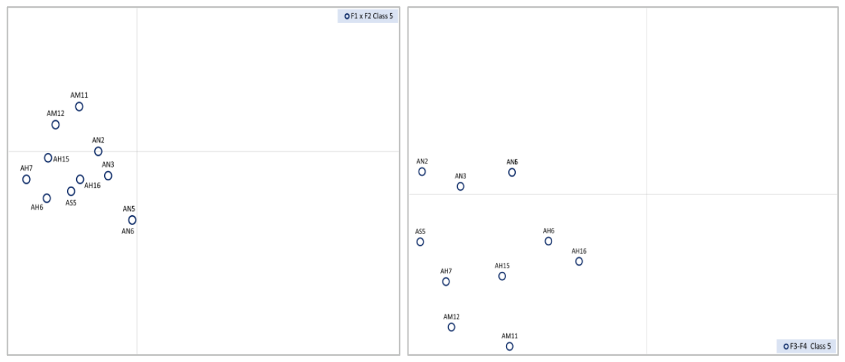
This class includes eleven Atlantic beaches, unevenly distributed among the four sectors (Figure 13). With one exception, these are extended beaches (0.7–3.7 km long and over 100 m wide), characterized by a gentle slope (< 0.03%) and fine to medium sediments (10–430 µm). The highest tides are locally strong to moderate (around 2.0–3.5 m). These beaches belong to littorals made of limestone, calcarenites, and sandy marls, dating from the secondary and tertiary periods. This class is quite compact in the F1xF2 plane but disperses in the F3xF4 plane and appears quite heterogeneous.
3.3.6. Class 6: Small and Gently Sloping Beaches with Fine Sediments
There is a dozen beaches in this group located throughout three geographic regions, including the Sahara, the Atlantic High Atlas and the Central Atlantic (Figure 14). Except for one, all these beaches have gentle slopes (0.01-0.03%) and less than 25 ha of area (30-80 m of width and 1.5-3 km of length. Sediments consist of medium to fine sands (< 500 µm) and the most amplified tides are of 2.7 m. The substrate materials consist of limestone and carbonates of the Secondary (Mesozoic) or Quaternary eras.
Figure 12.
Classification of Moroccan beaches: projection of class 4 on the F1xF2 (left) and F3xF4 (right) planes of the CA.
Figure 12.
Classification of Moroccan beaches: projection of class 4 on the F1xF2 (left) and F3xF4 (right) planes of the CA.
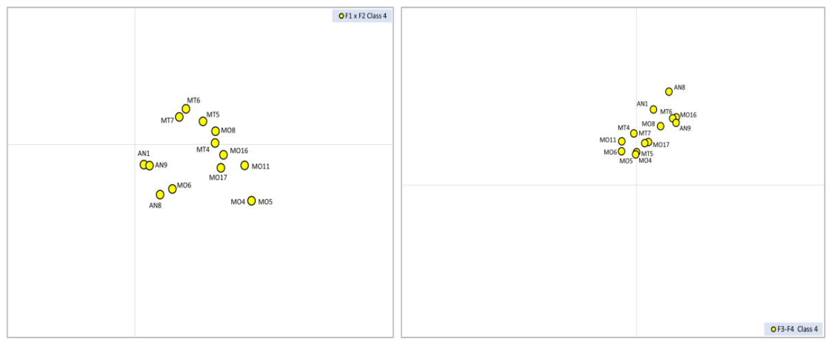
Figure 13.
Classification of Moroccan beaches: projection of class 5 on the F1xF2 (left) and F3xF4 (right) planes of the CA.
Figure 13.
Classification of Moroccan beaches: projection of class 5 on the F1xF2 (left) and F3xF4 (right) planes of the CA.
3.3.7. Class 7: Long Beaches with a Gentle Slope and Fine to Medium Sediments
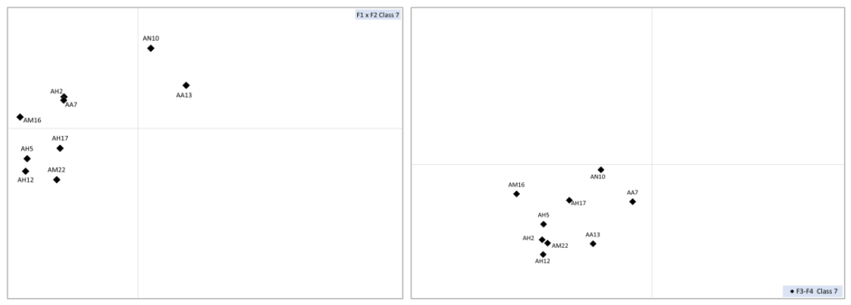
This class includes beaches from the non-Saharan Atlantic sectors (Figure 15); they have a very gentle slope (< 0.03%) and a low height (< 1 m), and a medium extent (26-50 ha, length of 2.3-3.6 km, and width of 21-56 m). Their sediments are fine (200-500 µm, sometimes enriched with coarse debris). These beaches are located on schist or sandstone terrains of varying ages.
Figure 14.
Classification of Moroccan beaches: projection of class 6 on the F1xF2 (left) and F3xF4 (right) planes of the CA.
Figure 14.
Classification of Moroccan beaches: projection of class 6 on the F1xF2 (left) and F3xF4 (right) planes of the CA.
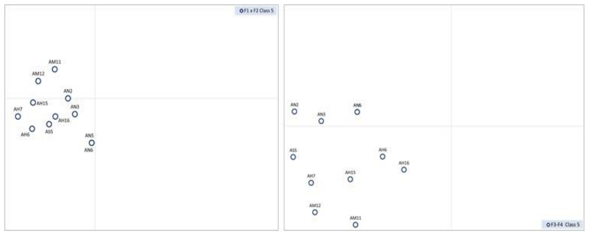
Figure 15.
Classification of Moroccan beaches: projection of class 7 on the F1xF2 (left) and F3xF4 (right) planes of the CA.
Figure 15.
Classification of Moroccan beaches: projection of class 7 on the F1xF2 (left) and F3xF4 (right) planes of the CA.
3.3.8. Class 8: Vast Beaches with Gentle Slopes and Fine Sediments, in Limestone Terrain
The five beaches that make up this class belong to the sectors of the North and Central Atlantic and the Sahara (Figure 16). They are distinguished by their large area, ranging from 120 to 320 hectares (with widths of 40-115 m and lengths of 10-26 km), and their gentle slope (0.02-0.05 µm), as well as their fine sand (around 250-500 µm). They are found in limestone and calcarenite littorals of Secondary to Quaternary eras.
3.3.9. Class 9: Large Beaches with Gentle Slopes and Medium-Sized Sediments
This class includes beaches belonging to the five Atlantic sectors and the Oriental coast (Figure 17). These are vast sandy beaches (50-100 ha, 4.5-11.0 km long and 13-70 m wide), with mostly gentle slopes (0.02-0.09%, but over 0.1% for two beaches). The equinox tide amplitude varies around 3.0 m, but it remains low (0.50 m) on the Mediterranean beaches. The sediments are of medium size (sands of 250 and 500 µm), rarely fine or coarse. These beaches are all formed in limestone or calcarenite of different ages.
3.3.10. Class 10: Gentle-Sloping Beaches with Medium-Sized Sediments, Narrow, with Short to Medium Length
The 16 beaches that constitute this class, entirely Saharan (Figure 18), are small (0.6-20 ha, with widths of 20-60 m and lengths of 0.3-2.6 km), and have a gentle slope (0.02-0.07, exceptionally above 0.1%). The sand is of medium size (500-1200 µm), subjected to relatively high equinox tides (2.2-3.4 m). For all of them, the coastal terrains are made of limestone, calcarenite and rarely of sandstone, dating back to the Secondary era.
3.3.11. Class 11: Small Fine Sandy Beaches, Near Estuaries and in Secondary Alluvium
The six beaches of this class (Figure 19) have a small extent (around 2-20 ha, with 0.8-4.7 km of length and generally 20-40 m of width). They are gently sloping (around 0.05-0.15%), and their sediments are fine to medium (125-580 μm). These beaches are developed at the foot of the Western Anti-Atlas reliefs (alluvium and Secondary conglomerates) and the central Rif (marls).
3.3.12. Class 12: Wide Beaches, with Very Gentle Slope and Medium Sand, Extending in Primary Terrain
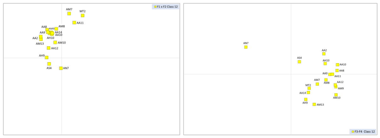
This class includes 16 Atlantic beaches, along with a beach from Tangier (Figure 20); they mostly belong to the coasts of the Anti-Atlas and the Central Atlantic. They have gentle slope (0.03 to 0.14%) and small extent (10-21 ha, exceptionally 40 ha), knowing that their width varies between 20 and 90 m and their length varies between 0.3 and 4.3 km. The sediments are rich in medium to fine sands (184-550 µm). These beaches belong to littorals mostly made up of primary limestone and calcarenite.
Figure 18.
Classification of Moroccan beaches: projection of class 10 on the F1xF2 (left) and F3xF4 (right) planes of the CA.
Figure 18.
Classification of Moroccan beaches: projection of class 10 on the F1xF2 (left) and F3xF4 (right) planes of the CA.
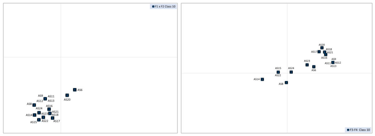
Figure 19.
Classification of Moroccan beaches: projection of class 11 on the F1xF2 (left) and F3xF4 (right) planes of the CA.
Figure 19.
Classification of Moroccan beaches: projection of class 11 on the F1xF2 (left) and F3xF4 (right) planes of the CA.
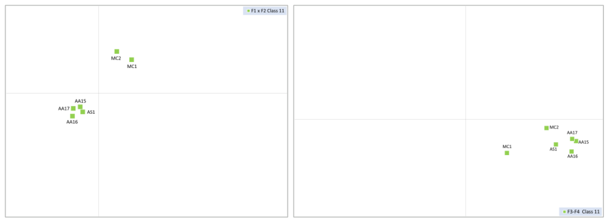
Figure 20.
Classification of Moroccan beaches: projection of class 12 on the F1xF2 (left) and F3xF4 (right) planes of the CA.
Figure 20.
Classification of Moroccan beaches: projection of class 12 on the F1xF2 (left) and F3xF4 (right) planes of the CA.
3.3.13. Class 13: Small Beaches with Moderate Slope and Sediment, at Mean Tide Level, Belonging to the Quaternary
This class contains eight beaches of the Central Atlantic and four of the Anti-Atlas coast, in addition to one beach of the High-Atlas coast (Figure 21). All of them have limited extent (1.1-17.1 ha, with 20-43 m of width and 0.4-2.7 km of length, with an exceptional value of 3.9 km). They are little steep (0.08-0.15%), and the equinox tides exceed 2.7 m; their sand is of medium size (300-500 µm). These beaches belong to littorals of varied geology, from the Palaeozoic to the Quaternary eras.
3.3.14. Class 14: Narrow and Small Beaches, with Medium to Coarse Sand
These are small sandy Atlantic beaches, spread along the coasts of the Central Atlantic and the High Atlas (Figure 22). With gentle slope (0.03 to 0.07%), they have a small extent (3-22 ha, with 21-58 km of width and 0.6-4.2 km of length). Beaten by very high equinox tides (3.4-3.7 m of amplitude), they are composed of fine to medium sands (170-680 µm). These beaches are formed in marly-sandy terrains of Quaternary, and more rarely Secondary, eras.
4. Discussion
This study offered a typology of the marine beaches of Morocco, established using corrected satellite data, supplemented by field-collected data. This typology, based on 10 morphodynamic and geological descriptors, is established by combining two complementary multivariate methods: HAC, which allowed the beaches' classification, and CA, mainly used to visualize this classification on the first factorial planes and identify its explanatory parameters.
The dendrogram established by the HAC yielded fourteen more or less homogeneous ‘clusters’, referred to as ‘classes’. The relevance of these classes is evidence that satellite data is relatively efficient in classifying beaches, as it has been in classifying the steep Moroccan coasts (Farhaoui et al. 2025). Nevertheless, field measurements have detected numerous inaccuracies in the satellite data, particularly those related to dimensions (length, width, height, and slope of the beaches), which are linked to the low resolution of the digital terrain model and some images. These inaccuracies justify the need to transform raw data into modalities (measurement classes).
Figure 23.
Geographical distribution of beach clusters. This shows how the regional variability of the littoral characteristics (mainly geology) that can impact the similarity between beaches.
Figure 23.
Geographical distribution of beach clusters. This shows how the regional variability of the littoral characteristics (mainly geology) that can impact the similarity between beaches.
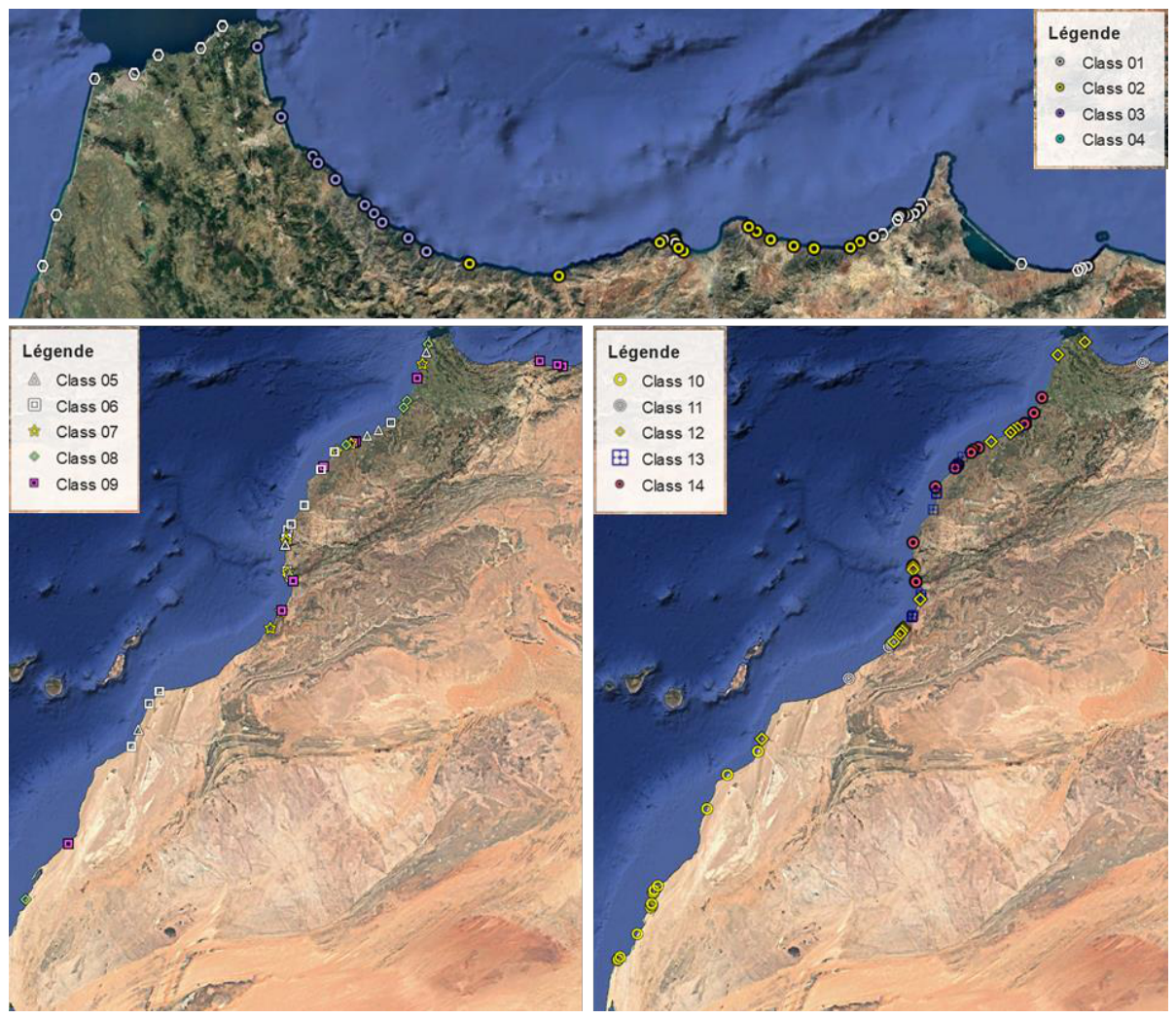
The description of the different classes revealed that five descriptors played a major discriminative role in the typology of beaches: slope, sediment grain size, equinox tide amplitude, beach width and length. All these parameters largely reflect the orography of the littoral (McNinch, 2004; Jackson et al., 2005; Short, 2010), although orography itself was not used as a classification criterion. Thus, the coastlines on the margins of plains and low plateaus exhibit the least steep beaches, with fine to medium grain size and great extent (Charrouf, 1991). This is well verified on both marine sides: Atlantic (Gharb, Doukkala, Souss, Guelmim), and Mediterranean (small Eastern plains of the Tingitane peninsula and Oriental coastal plains). Conversely, the steepest and least extensive beaches, with coarse sediments, are generally found at the foot of steep mountain slopes (Central Rif, Tingitane Peninsula, Atlantic High Atlas and Kebdana). The sloped shores often plunge steeply under the coastal waters, offering very narrow foreshores, regularly supplied with rocky debris from these slopes, which makes their sediments coarse. In addition to their narrow width, these beaches are short, due to the numerous valleys that cut through these slopes and offer little space between them.
The swell amplitude, represented here by its highest values (at the equinoxes), is largely responsible for the separation between the beaches of the Mediterranean and Atlantic sectors, where this swell hardly exceeds 60 cm, and those of the Atlantic, where it often exceeds 2.5 meters. Apart from this separation, this parameter plays a secondary role in the typology of Atlantic beaches, without contradicting the role of hydrodynamics in the shaping of littorals (Masselink & Short, 1993, Davis & Hayes 1984, Burvingt et al. 2017, Scott et al. 2011, Mohd Zaini et al. 2015).
The height of the beaches, a parameter also related to their slope and wave amplitude, seems to have played a secondary role in our typology; this would be due to the inaccuracies in estimating this parameter, linked to the low resolution of the available digital terrain models. This height introduces variations within the beach classes, but it remains secondary and non-decisive for the classification, owing to variations between beaches linked to their genesis and morphology (Araya-Vergara, 1986) and to storm tides and their fluctuations (Burvingt et al., 2017). For this reason, regular field monitoring is advisable, as it could provide a basis for assessing changes in beach elevation over time.
The geology (nature of the rocks, era), which largely defines the morphology of the littoral (Short, 2010), indirectly influences the overall typology of the beaches; indeed, a certain grouping of beaches according to the major coastal structural units is noted, roughly illustrated by the distribution of coastal orohydrographic sectors in the CA planes. However, within each of these units, spatial variations in the rocks are noted, which introduce a certain irregularity in the intervention of this descriptor. The geological era, which often varies within a single sector, intervenes mainly in the detailed typology by creating intra-class variants, but it sometimes contributes to defining certain classes. Consequently, to make this classification usable outside Morocco, geology was not taken into account in developing the typological key presented above. The distance to the nearest estuary, which varies greatly from one estuary to another, made no significant contribution to the classification of beaches, as all these lie beyond the influence of estuaries. Let us recall that estuarine beaches, which depend mainly on the characteristics of the lower river course, are excluded from the classification of marine beaches.
The morphodynamic similarities highlighted by HAC and CA reveal that in certain classes, the beaches belong to the same sector, and their great resemblance is justified by the fact that they are shaped by the same regional parameters. However, several classes bring together beaches from different littoral sectors — sometimes from all the sectors defined for the country; this justifies giving priority to the typological role of the descriptors over geographical proximity.
Our classification has the advantage of being based on multiple criteria, which sets it apart from those based on one or two criteria (Wright and Short 1984, Davies and Hayes 1984, Masselink and Short 1993, Burvingt et al. 2017), which are primarily hydrodynamic (high tides, waves, storms). However, our classification is more or less in agreement with those of Micallef & Williams (2004) and Roig-Munar et al. (2013), which are based on many criteria, including human-related data.
Furthermore, this study has led to the establishment of a Moroccan database of marine beach descriptors, which is likely to serve as a data source for future research (such as wetland inventory, habitat typology, and the effects of sea level rise). The study also complements the few available works on coastal management and conservation (Snoussi 2002, Sbai et al. 2004, Cahoon & Guntenspergen 2010). Drawing on the Moroccan coastal environment, our classification could be useful for establishing similar classifications of marine beaches in neighbouring countries, although we recommend that future studies integrate descriptors specific to those countries.
5. Conclusions
This article sets out a comprehensive typology of beaches as part of the broader programme of inventory and classification of Moroccan wetlands, based on databases and multivariate analyses (Dakki 2022). The approach is deliberately simple, relying on a minimal set of criteria that are mostly accessible through remote sensing or web services. The ten selected criteria, analysed using a Hierarchical Ascending Classification (HAC) and the Correspondence Analysis (CA), made it possible to split the 163 beaches into 14 classes. These criteria can usually be reduced to a few categories of parameters that mainly define the morphology, hydrodynamics, slope, and grain size of the sediments, characteristics in which the geology of the littoral plays a significant role. Users of classifications often prefer simplified hierarchical classifications (such as dichotomous keys) to the multivariate clustering. In this respect, the present work has the advantage of highlighting few relevant criteria on which users can rely (at least in part) to develop their own hierarchical scheme, bearing in mind that each study guides its choice of criteria according to its classification objectives. We present below an illustrative example of valid scheme (Table 3).
The classification presented here should be understood as the first national reference framework for Moroccan beaches, and it can also serve as a model for other classifications. It is intended as a complement to the existing classification of Moroccan wetlands (Dakki, 2022) and can help to inform decisions related to land-use planning.
Name: Site name; X: longitude; Y: latitudelatitude ; S : Surface (ha) ; Z : Altitud (m) ; L : Width (m) ; LO : Length (m) ; P : Average slope (%) ; DE : Distance from the Estuary(m); MH : High tides(m); GS : Grain size median (μm/mm) ; NR: Nature of rocks; EG : Geological era.
Acknowledgments
The authors would like to express their sincere gratitude to Professor Nadia Mhammdi, from the Laboratory of Geophysics and Natural Hazards at the Scientific Institute of Rabat, for her valuable support in the sand analyses.
Appendix A. Physiographic Data Matrix, in Real Values, Used for the Classification of Moroccan Beaches
| Beach Name | X | Y | S | Z | L | LO | P | DE | MH | GS | NR | EG |
| Essaidia | -2.259527 | 35.098358 | 92,08 | 2 | 19 | 7767 | 5,41 | 4986 | 0,45 | 444,16 | Marl-sandstone | Tertiary |
| Ras El Ma | -2.401363 | 35.136477 | 55,95 | 1 | 20 | 4486 | 5,00 | 3041 | 0,48 | 181,40 | Marl-sandstone | Tertiary |
| Thimarssad | -2.489632 | 35.100313 | 0,20 | 5 | 11 | 138 | 9,49 | 16132 | 0,48 | 581,00 | Marl-sandstone | Tertiary |
| Rouge | -2.511512 | 35.092566 | 1,06 | 4 | 3 | 388 | 33,33 | 17244 | 0,48 | 571,33 | Marl-sandstone | Tertiary |
| Sidi El Bachir | -2.526843 | 35.088154 | 1,83 | 4 | 20 | 513 | 5,05 | 19356 | 0,48 | 517,15 | Marl-sandstone | Tertiary |
| Kariate Arkmane | -2.723442 | 35.116854 | 19,64 | 1 | 23 | 2400 | 4,42 | 36478 | 0,48 | 452,72 | Marl-sandstone | Tertiary |
| Boukhana | -2.890235 | 35.234913 | 70,53 | 1 | 26 | 8456 | 3,88 | 3698 | 0,48 | 456,90 | Marl-sandstone | Tertiary |
| Messadit | -3.059923 | 35.303208 | 1,39 | 5 | 24 | 337 | 12,50 | 17047 | 0,64 | 426,57 | Marls | Tertiary |
| Palomas | -3.067069 | 35.295027 | 0,25 | 4 | 13 | 220 | 15,22 | 17311 | 0,64 | 422,55 | Marls | Tertiary |
| Izammourane | -3.083827 | 35.280905 | 0,35 | 4 | 23 | 275 | 8,77 | 14302 | 0,64 | 418,67 | Marls | Tertiary |
| Bouyafar | -3.106876 | 35.272482 | 1,83 | 3 | 17 | 830 | 11,83 | 11136 | 0,64 | 352,43 | Marls | Tertiary |
| Sidi Measasoud | -3.120720 | 35.278381 | 0,44 | 4 | 20 | 196 | 14,84 | 10592 | 0,64 | 404,89 | Marls | Tertiary |
| Tarzout | -3.134298 | 35.280271 | 0,26 | 7 | 14 | 165 | 14,04 | 8576 | 0,64 | 253,37 | Marls | Tertiary |
| L'azizatene | -3.135452 | 35.279055 | 0,23 | 4 | 17 | 141 | 12,11 | 8363 | 0,64 | 261,78 | Marls | Tertiary |
| Imoussatene | -3.139740 | 35.274760 | 0,29 | 7 | 25 | 184 | 4,03 | 7652 | 0,64 | 495,55 | Marls | Tertiary |
| Al-Kallat | -3.148274 | 35.262980 | 10,51 | 2 | 23 | 2113 | 4,37 | 4937 | 0,64 | 590,38 | Marls | Tertiary |
| Boundouha | -3.202748 | 35.224207 | 3,52 | 2 | 27 | 1077 | 3,70 | 10 | 0,64 | 618,49 | Marls | Tertiary |
| Ifri Ifounassene | -3.232155 | 35.221596 | 0,42 | 9 | 16 | 213 | 18,40 | 3852 | 0,64 | 15500,00 | Marls | Tertiary |
| Sidi Bousaid | -3.280364 | 35.209319 | 1,09 | 4 | 11 | 319 | 19,05 | 8450 | 0,64 | 14500,00 | Marls | Tertiary |
| Ghansou | -3.316220 | 35.194755 | 9,34 | 7 | 16 | 1388 | 19,35 | 11546 | 0,64 | 14500,00 | Schist | Secondary |
| Sidi Hessaine | -3.442871 | 35.197362 | 1,35 | 2 | 9 | 506 | 10,75 | 23559 | 0,64 | 15500,00 | Schist | Secondary |
| Sidi Aamar Omoussa | -3.513004 | 35.208100 | 41,46 | 2 | 10 | 5050 | 10,31 | 2718 | 0,64 | 15500,00 | Marls | Tertiary |
| Sidi Driss | -3.591275 | 35.229765 | 32,05 | 3 | 11 | 7979 | 18,87 | 798 | 0,64 | 15800,00 | Marls | Tertiary |
| Aghrabo Nzrin | -3.638545 | 35.254193 | 21,62 | 3 | 15 | 2773 | 13,61 | 7577 | 0,64 | 15700,00 | Marls | Tertiary |
| Yawmzir | -3.665469 | 35.269462 | 6,98 | 5 | 16 | 1843 | 19,35 | 10902 | 0,64 | 24500,00 | Marls | Tertiary |
| Tanda-El harch | -3.797983 | 35.207807 | 21,51 | 3 | 19 | 4690 | 5,24 | 370 | 0,66 | 181,61 | alluvium | Quaternary |
| Souani | -3.848258 | 35.198562 | 16,74 | 2 | 20 | 3915 | 5,10 | 340 | 0,66 | 580,09 | alluvium | Quaternary |
| Sofiha | -3.896568 | 35.209495 | 10,35 | 3 | 12 | 2266 | 17,39 | 1587 | 0,66 | 177,43 | Limestone | Secondary |
| Isri | -3.912842 | 35.219655 | 1,87 | 5 | 19 | 391 | 15,88 | 4405 | 0,66 | 178,14 | Limestone | Secondary |
| Cala Bonita | -3.922849 | 35.234586 | 0,42 | 7 | 21 | 113 | 4,72 | 6339 | 0,66 | 176,78 | Limestone | Secondary |
| Quemado | -3.926222 | 35.244109 | 1,47 | 6 | 21 | 314 | 4,83 | 7444 | 0,66 | 175,20 | Limestone | Secondary |
| Azdih | -3.963365 | 35.245266 | 0,52 | 8 | 17 | 261 | 12,11 | 13720 | 0,66 | 179,70 | Schist | Palaeozoic |
| Tala youssef | -3.976762 | 35.237900 | 3,63 | 8 | 21 | 1080 | 14,62 | 14903 | 0,66 | 174,50 | Limestone | Secondary |
| Torrès | -4.332613 | 35.156678 | 2,23 | 5 | 10 | 560 | 19,42 | 4339 | 0,66 | 170000,00 | Flysch | Secondary |
| Lehwad | -4.640315 | 35.203175 | 18,22 | 5 | 10 | 2636 | 31,58 | 3210 | 0,66 | 190000,00 | Flysch | Secondary |
| Amtar | -4.787703 | 35.242725 | 11,16 | 1 | 22 | 1755 | 4,65 | 20 | 0,66 | 773,96 | Schist | Palaeozoic |
| Jnanich | -4.848907 | 35.283256 | 10,21 | 5 | 20 | 1914 | 10,00 | 5553 | 0,66 | 1063,41 | Schist | Palaeozoic |
| Chamaala | -4.938016 | 35.331053 | 6,17 | 1 | 19 | 698 | 5,18 | 10 | 0,66 | 672,59 | Schist | Palaeozoic |
| Stihat | -4.965103 | 35.357442 | 17,46 | 2 | 15 | 2041 | 6,90 | 2506 | 0,66 | 578,96 | Gneiss | Palaeozoic |
| Azenti | -4.996197 | 35.381750 | 6,36 | 5 | 14 | 1227 | 29,63 | 10276 | 0,66 | 1491,18 | Schist | Palaeozoic |
| Oued Laou | -5.095289 | 35.458293 | 31,76 | 1 | 16 | 4728 | 6,45 | 10 | 0,95 | 560,85 | Schist | Palaeozoic |
| Aouchtam | -5.154562 | 35.506916 | 3,88 | 5 | 14 | 1778 | 14,29 | 10336 | 0,95 | 1434,14 | Schist | Palaeozoic |
| Tamernout | -5.171987 | 35.528085 | 2,03 | 8 | 17 | 556 | 11,57 | 13298 | 0,95 | 1424,79 | Schist | Palaeozoic |
| Martil | -5.277623 | 35.642076 | 57,42 | 2 | 20 | 6073 | 4,93 | 10 | 0,95 | 986,53 | Schist | Palaeozoic |
| M'diq | -5.328329 | 35.700410 | 20,96 | 3 | 21 | 4248 | 9,62 | 10 | 0,95 | 430,02 | Schist | Palaeozoic |
| Fnideq | -5.353092 | 35.845543 | 2,23 | 2 | 12 | 804 | 8,70 | 10 | 0,95 | 527,17 | Schist | Palaeozoic |
| Dalia | -5.476712 | 35.905970 | 4,57 | 4 | 21 | 791 | 14,29 | 2991 | 1,04 | 289,16 | Flysch | Tertiary |
| Ksar Sghir | -5.555523 | 35.845066 | 5,19 | 2 | 11 | 975 | 8,93 | 5 | 1,41 | 289,26 | Flysch | Tertiary |
| Sidi Kankouche | -5.706954 | 35.830165 | 2,50 | 2 | 18 | 536 | 5,69 | 6333 | 1,96 | 282,88 | Flysch | Tertiary |
| Tanger | -5.794012 | 35.778589 | 20,47 | 2 | 25 | 1847 | 4,00 | 10 | 1,8 | 260,00 | Flysch | Tertiary |
| Achakar | -5.935029 | 35.768980 | 9,33 | 2 | 27 | 1384 | 3,70 | 22586 | 1,96 | 260,00 | Limestone | Tertiary |
| Sidi Kacem | -5.941733 | 35.745302 | 53,29 | 2 | 107 | 3145 | 0,94 | 19268 | 1,96 | 260,00 | Limestone | Tertiary |
| Grouttes Hercule | -5.950450 | 35.718248 | 39,21 | 2 | 125 | 2056 | 0,80 | 16432 | 1,96 | 260,00 | Limestone | Tertiary |
| Hajryène | -5.968880 | 35.662600 | 155,04 | 2 | 86 | 10357 | 1,16 | 8318 | 1,96 | 260,00 | Limestone | Tertiary |
| Asilah | -6.025365 | 35.483266 | 9,63 | 3 | 122 | 1908 | 1,64 | 500 | 2,66 | 209,50 | Marl-sandstone | Tertiary |
| Asilah Port | -6.028845 | 35.474212 | 4,92 | 3 | 135 | 665 | 1,48 | 500 | 2,66 | 219,04 | Marl-sandstone | Tertiary |
| Coves lhmame | -6.066448 | 35.417074 | 39,52 | 4 | 92 | 3152 | 3,28 | 3590 | 2,66 | 395,72 | Marl-sandstone | Tertiary |
| Sidi Mghayet | -6.083471 | 35.383748 | 2,75 | 5 | 34 | 1014 | 8,82 | 16515 | 2,66 | 453,89 | Marl-sandstone | Tertiary |
| Lixus | -6.136420 | 35.239225 | 17,72 | 6 | 52 | 2182 | 9,62 | 3374 | 2,66 | 438,90 | Flysch | Tertiary |
| Ras R'mel | -6.146562 | 35.214327 | 34,12 | 3 | 22 | 3113 | 9,09 | 2 | 2,84 | 436,28 | Flysch | Tertiary |
| Moulay Bousselham | -6.292087 | 34.890880 | 53,27 | 5 | 14 | 5593 | 14,81 | 35602 | 2,84 | 256,25 | Limestone | Quaternary |
| Boukmour | -6.514302 | 34.488005 | 21,79 | 9 | 54 | 4248 | 11,07 | 29595 | 3,7 | 243,64 | Limestone | Quaternary |
| Chelihate | -6.603339 | 34.364316 | 319,06 | 5 | 93 | 26224 | 4,30 | 10 | 3,7 | 243,64 | Calcarenites | Quaternary |
| Mehdia | -6.702008 | 34.208884 | 306,55 | 3 | 115 | 13973 | 1,74 | 10 | 3,74 | 409,99 | Calcarenites | Quaternary |
| des Nations | -6.735929 | 34.150654 | 7,41 | 3 | 55 | 1234 | 3,64 | 13765 | 3,74 | 409,99 | Calcarenites | Quaternary |
| Guy Ville | -6.945144 | 33.937226 | 2,88 | 4 | 20 | 1089 | 9,92 | 14804 | 3,42 | 436,63 | Calcarenites | Quaternary |
| Contrebandiers | -6.965301 | 33.922625 | 5,97 | 2 | 52 | 985 | 3,86 | 4552 | 3,42 | 313,38 | Limestone | Quaternary |
| Sable d'ore | -6.970662 | 33.919093 | 2,68 | 2 | 58 | 645 | 3,43 | 3956 | 3,42 | 469,70 | Limestone | Quaternary |
| Val D'Or | -6.983359 | 33.910454 | 3,07 | 2 | 37 | 829 | 5,46 | 1814 | 3,42 | 490,17 | Limestone | Quaternary |
| Skhirat | -7.058151 | 33.869966 | 9,54 | 2 | 76 | 9371 | 2,64 | 10 | 3,42 | 271,89 | Limestone | Quaternary |
| Bouznika | -7.158359 | 33.819460 | 9,29 | 2 | 20 | 3341 | 4,90 | 2 | 3,42 | 447,21 | Limestone | Quaternary |
| Dahomey | -7.186384 | 33.808201 | 14,11 | 2 | 22 | 2974 | 4,55 | 3117 | 3,42 | 450,52 | Limestone | Palaeozoic |
| Daya Mansourya | -7.287921 | 33.763283 | 5,59 | 5 | 64 | 1523 | 4,72 | 7202 | 3,65 | 312,41 | Limestone | Palaeozoic |
| Monica | -7.354162 | 33.715250 | 3,05 | 2 | 36 | 1321 | 5,49 | 10 | 3,65 | 347,66 | Limestone | Palaeozoic |
| Manessmane | -7.366137 | 33.710722 | 7,88 | 2 | 40 | 2376 | 5,06 | 2256 | 3,65 | 236,56 | Limestone | Palaeozoic |
| Mohammadia | -7.386163 | 33.709345 | 20,80 | 1 | 105 | 2569 | 0,95 | 1244 | 3,65 | 181,00 | Limestone | Palaeozoic |
| Aine Diab | -7.690208 | 33.587104 | 53,52 | 1 | 167 | 3315 | 0,60 | 116562 | 3,65 | 185,00 | Limestone | Palaeozoic |
| Al Hajra Al Kahla | -7.861669 | 33.515956 | 13,99 | 2 | 66 | 2748 | 1,52 | 49791 | 3,65 | 184,00 | Limestone | Palaeozoic |
| Sidi Rahal | -7.981640 | 33.470995 | 68,42 | 1 | 55 | 6230 | 1,82 | 28888 | 3,65 | 304,70 | Limestone | Palaeozoic |
| Mozona | -8.043372 | 33.446204 | 76,33 | 1 | 28 | 8203 | 3,57 | 29302 | 3,49 | 345,82 | Limestone | Palaeozoic |
| Sidi Yakoub | -8.113190 | 33.421085 | 48,33 | 1 | 39 | 6396 | 2,56 | 23286 | 3,49 | 198,03 | Limestone | Quaternary |
| Lemressa | -8.171019 | 33.404362 | 3,76 | 1 | 21 | 1367 | 4,76 | 19218 | 3,49 | 262,03 | Limestone | Quaternary |
| Sidi Bounaime | -8.239165 | 33.383136 | 199,98 | 1 | 43 | 14024 | 2,30 | 8781 | 3,49 | 320,12 | Limestone | Quaternary |
| Daya | -8.308147 | 33.358113 | 11,30 | 1 | 24 | 3290 | 4,17 | 4309 | 3,49 | 343,89 | Limestone | Quaternary |
| Lala Aîcha | -8.333477 | 33.324591 | 2,47 | 3 | 16 | 1226 | 12,82 | 500 | 3,49 | 18800,00 | Limestone | Quaternary |
| El-Haouzia | -8.358426 | 33.305715 | 17,95 | 3 | 51 | 3900 | 3,90 | 500 | 3,49 | 188,00 | Limestone | Quaternary |
| El Jadida | -8.492069 | 33.248506 | 34,29 | 1 | 34 | 2603 | 2,94 | 17401 | 3,49 | 637,42 | Limestone | Secondary |
| Sidi Bouzid | -8.556064 | 33.226631 | 17,98 | 1 | 62 | 1507 | 1,62 | 25759 | 3,47 | 613,89 | Limestone | Secondary |
| Moulay Abdellah | -8.598284 | 33.191733 | 1,11 | 2 | 20 | 372 | 5,00 | 31283 | 3,47 | 491,35 | Limestone | Quaternary |
| Sidi Abed | -8.694728 | 33.045725 | 19,37 | 2 | 43 | 2662 | 4,65 | 31248 | 3,47 | 635,67 | Limestone | Quaternary |
| Harchane | -8.728571 | 33.008327 | 12,96 | 1 | 29 | 2506 | 3,40 | 53454 | 3,47 | 684,08 | Limestone | Quaternary |
| Sidi Belkheir | -8.740528 | 32.998062 | 1,76 | 3 | 28 | 692 | 3,52 | 60487 | 3,47 | 365,07 | Limestone | Quaternary |
| Sidi Moussa | -8.765074 | 32.971382 | 6,43 | 2 | 35 | 2522 | 2,86 | 63704 | 3,47 | 444,33 | Limestone | Quaternary |
| Mrizika | -8.787113 | 32.948246 | 16,51 | 3 | 30 | 3925 | 6,75 | 67805 | 3,47 | 436,28 | Limestone | Quaternary |
| Ouled Salem | -8.825663 | 32.912820 | 57,64 | 3 | 34 | 8685 | 5,88 | 70319 | 3,47 | 1023,91 | Limestone | Quaternary |
| Ouled Ghanem | -8.914343 | 32.831680 | 22,47 | 1 | 37 | 4150 | 2,73 | 81785 | 3,47 | 483,69 | Limestone | Quaternary |
| El Beddouza | -9.257966 | 32.561650 | 21,32 | 2 | 30 | 6187 | 3,33 | 128002 | 3,47 | 467,22 | Limestone | Quaternary |
| Baaliten | -9.249756 | 32.415226 | 2,08 | 13 | 43 | 764 | 18,60 | 49063 | 3,63 | 444,48 | Limestone | Secondary |
| Lalla Fatna | -9.260702 | 32.400208 | 2,73 | 13 | 27 | 823 | 33,58 | 46647 | 3,63 | 403,64 | Limestone | Secondary |
| Kleisa | -9.332761 | 32.062723 | 4,86 | 8 | 27 | 1214 | 14,81 | 3529 | 3,51 | 376,46 | Limestone | Quaternary |
| Essouiria Guedima | -9.342564 | 32.040536 | 7,62 | 1 | 51 | 1809 | 1,96 | 500 | 3,51 | 293,75 | Limestone | Quaternary |
| Moulay | -9.678308 | 31.627333 | 11,22 | 1 | 38 | 3065 | 2,61 | 46125 | 3,51 | 178,68 | Limestone | Secondary |
| Essaouira | -9.766755 | 31.502280 | 46,09 | 1 | 61 | 2394 | 1,63 | 1250 | 3,51 | 128,62 | sandstone | Quaternary |
| Taguenza | -9.810398 | 31.377651 | 7,19 | 1 | 31 | 1938 | 3,20 | 16015 | 3,43 | 167,85 | sandstone | Quaternary |
| Sidi Kaouki | -9.797865 | 31.346364 | 30,35 | 1 | 56 | 2775 | 1,78 | 19743 | 3,43 | 461,88 | sandstone | Quaternary |
| Azro | -9.795089 | 31.319038 | 14,85 | 1 | 36 | 2089 | 2,81 | 22982 | 3,43 | 428,06 | Limestone | Secondary |
| Takouchette | -9.797138 | 31.300954 | 8,06 | 4 | 38 | 1840 | 5,29 | 26598 | 3,43 | 338,16 | Limestone | Secondary |
| Sidi Embarek | -9.801593 | 31.276303 | 26,51 | 1 | 37 | 3411 | 2,74 | 27917 | 3,43 | 320,12 | Limestone | Secondary |
| Iftane | -9.816582 | 31.193931 | 12,17 | 2 | 128 | 1140 | 1,56 | 55577 | 3,43 | 363,23 | Limestone | Secondary |
| Sidi Ahmed Essayeh | -9.821969 | 31.178366 | 29,68 | 1 | 150 | 2742 | 0,67 | 55074 | 3,43 | 346,67 | Limestone | Secondary |
| Zaouia Tliet | -9.808525 | 30.891480 | 6,47 | 12 | 56 | 746 | 17,76 | 23322 | 3,43 | 187,04 | Limestone | Secondary |
| Imsouane | -9.817943 | 30.840937 | 19,26 | 12 | 64 | 2934 | 15,75 | 15542 | 3,43 | 183,72 | sandstone | Secondary |
| Afra | -9.818349 | 30.786928 | 15,24 | 12 | 81 | 1549 | 12,35 | 9071 | 3,43 | 415,86 | sandstone | Quaternary |
| Aghroude I Imi ouaddar | -9.780014 | 30.603483 | 24,21 | 2 | 80 | 2280 | 2,50 | 33664 | 3,43 | 380,89 | Limestone | Secondary |
| Aghroude-II | -9.761760 | 30.586335 | 27,68 | 1 | 43 | 3122 | 2,31 | 30858 | 3,43 | 234,66 | Limestone | Secondary |
| Azazoul | -9.746253 | 30.568909 | 15,17 | 3 | 41 | 1778 | 4,85 | 28794 | 3,43 | 239,24 | Limestone | Secondary |
| La Source | -9.730946 | 30.548024 | 7,82 | 2 | 40 | 1348 | 2,50 | 25294 | 3,43 | 229,83 | Limestone | Secondary |
| Imourane | -9.696243 | 30.526708 | 64,91 | 1 | 71 | 4661 | 1,40 | 19154 | 3,43 | 243,64 | Limestone | Secondary |
| Aourir | -9.675812 | 30.487332 | 21,18 | 2 | 101 | 2060 | 1,97 | 16427 | 3,43 | 216,03 | Limestone | Secondary |
| Anza | -9.651243 | 30.436749 | 33,21 | 1 | 52 | 2294 | 1,94 | 9397 | 3,43 | 323,00 | Limestone | Secondary |
| Agadir | -9.605756 | 30.403796 | 86,33 | 3 | 70 | 5929 | 2,87 | 5400 | 3,43 | 279,00 | Limestone | Secondary |
| Sidi Toual | -9.628613 | 30.254269 | 14,94 | 2 | 21 | 2221 | 4,76 | 12741 | 3,38 | 317,21 | Limestone | Quaternary |
| Tifnit | -9.640267 | 30.196445 | 9,55 | 4 | 36 | 2096 | 5,56 | 19059 | 3,38 | 323,04 | Limestone | Quaternary |
| Douira | -9.644782 | 30.162217 | 8,15 | 5 | 64 | 1264 | 6,24 | 4713 | 3,38 | 335,04 | Calcarenites | Quaternary |
| Timzilt | -9.820376 | 29.827490 | 5,97 | 6 | 39 | 1452 | 12,82 | 31825 | 3,38 | 299,73 | Calcarenites | Quaternary |
| Aglou | -9.838117 | 29.801552 | 7,19 | 3 | 20 | 1652 | 5,00 | 34712 | 3,38 | 328,96 | Limestone | Quaternary |
| Roche rouge | -9.853438 | 29.787517 | 17,09 | 3 | 22 | 2714 | 9,09 | 41822 | 3,38 | 314,32 | Limestone | Precambrian |
| Mimide | -9.886568 | 29.758438 | 79,31 | 2 | 41 | 6976 | 2,41 | 50295 | 3,38 | 331,97 | Calcarenites | Quaternary |
| Sidi Bounouar | -9.924796 | 29.728157 | 34,62 | 3 | 39 | 4675 | 5,18 | 50300 | 3,38 | 320,12 | Limestone | Precambrian |
| Tamhrouchte | -10.056810 | 29.553998 | 4,66 | 6 | 36 | 770 | 13,84 | 1708 | 3,38 | 308,52 | Limestone | Precambrian |
| Sidi El Wafi | -10.067605 | 29.536187 | 9,23 | 5 | 59 | 1004 | 6,75 | 10 | 3,38 | 311,42 | Limestone | Precambrian |
| Ftaysa Rkount | -10.071161 | 29.514892 | 4,25 | 4 | 37 | 612 | 8,11 | 3185 | 3,38 | 266,80 | Limestone | Precambrian |
| Tiboujatine | -10.084747 | 29.494328 | 0,96 | 6 | 22 | 405 | 18,18 | 5285 | 3,38 | 367,17 | sandstone | Precambrian |
| Legzira | -10.118024 | 29.443783 | 6,96 | 7 | 51 | 1272 | 11,76 | 44492 | 3,38 | 387,28 | sandstone | Precambrian |
| Sidi Ifni | -10.184783 | 29.371302 | 43,69 | 4 | 21 | 3559 | 14,29 | 34151 | 3,36 | 105000,00 | sandstone | Precambrian |
| Sidi Ouarzeg | -10.275757 | 29.270032 | 19,75 | 4 | 62 | 3107 | 4,85 | 19628 | 3,36 | 315,00 | Schist | Palaeozoic |
| Ahl Bouchaite | -10.324946 | 29.237236 | 1,99 | 10 | 38 | 757 | 21,29 | 13864 | 3,36 | 200,00 | Conglomerate | Secondary |
| Sidi Ali Jama | -10.347845 | 29.212007 | 5,20 | 2 | 40 | 961 | 2,47 | 10180 | 3,36 | 145,00 | Conglomerate | Secondary |
| Blanche | -10.396362 | 29.158711 | 13,11 | 2 | 38 | 1340 | 2,61 | 2493 | 3,36 | 125,00 | Conglomerate | Secondary |
| El Ouatia | -11.348000 | 28.485949 | 11,82 | 5 | 85 | 1400 | 4,72 | 31223 | 3,35 | 450,00 | Conglomerate | Secondary |
| Terfaya | -12.924540 | 27.947315 | 9,78 | 2 | 76 | 1816 | 1,31 | 108189 | 3,23 | 160,00 | Limestone | Secondary |
| Hassi Tafrawt | -13.169235 | 27.676858 | 15,68 | 1 | 73 | 2693 | 1,37 | 55748 | 3,23 | 276,00 | Limestone | Secondary |
| Nagjir | -13.399671 | 27.175510 | 19,70 | 3 | 77 | 3201 | 2,59 | 2944 | 3,44 | 315,00 | Marl-sandstone | Secondary |
| El Bir | -13.420377 | 27.109292 | 50,70 | 1 | 126 | 3470 | 0,79 | 12914 | 3,44 | 429,00 | Marl-sandstone | Secondary |
| Tarouma | -13.488315 | 26.904812 | 0,60 | 4 | 23 | 327 | 8,72 | 36493 | 3,44 | 1200,00 | Marl-sandstone | Secondary |
| Zbarat | -13.578802 | 26.727795 | 8,25 | 2 | 63 | 1968 | 3,15 | 56220 | 3,44 | 500,00 | Marl-sandstone | Secondary |
| Sid Al Ghazi | -14.205736 | 26.383521 | 1,25 | 1 | 36 | 465 | 2,78 | 131868 | 3,44 | 510,00 | Marl-sandstone | Secondary |
| Aouinat Tartar | -14.676613 | 25.636045 | 5,31 | 7 | 47 | 1568 | 8,51 | 126236 | 3,44 | 535,00 | Marl-sandstone | Secondary |
| des Balaines | -15.077863 | 24.525267 | 64,64 | 5 | 63 | 11313 | 1,59 | 95910 | 3,44 | 520,00 | Marl-sandstone | Secondary |
| Hajart Lamgat | -15.824871 | 23.899015 | 7,46 | 4 | 57 | 1536 | 3,51 | 32478 | 3,44 | 564,00 | Marl-sandstone | Secondary |
| Oum-Gwira | -15.913787 | 23.801440 | 1,13 | 5 | 47 | 455 | 4,28 | 43103 | 3,44 | 576,00 | Marl-sandstone | Secondary |
| Oum Labayer | -15.922778 | 23.763838 | 3,90 | 3 | 57 | 1031 | 3,50 | 50485 | 3,44 | 765,00 | Marl-sandstone | Secondary |
| Dakhla | -15.937582 | 23.740228 | 20,02 | 1 | 58 | 2558 | 1,72 | 53183 | 2,38 | 564,00 | Marl-sandstone | Secondary |
| koudyet Tiskme | -15.965783 | 23.499213 | 2,53 | 1 | 41 | 730 | 2,44 | 18375 | 2,38 | 643,00 | Marl-sandstone | Secondary |
| Porto Rico | -15.952797 | 23.473964 | 6,36 | 10 | 46 | 2011 | 15,20 | 20773 | 2,38 | 683,00 | Marl-sandstone | Secondary |
| La Garita | -15.958485 | 23.458702 | 6,45 | 8 | 41 | 2069 | 14,67 | 22856 | 2,38 | 1021,00 | Marl-sandstone | Secondary |
| Labburda | -15.982580 | 23.413674 | 14,77 | 8 | 57 | 1763 | 12,27 | 28185 | 2,38 | 980,00 | Marl-sandstone | Secondary |
| Imlili | -16.137503 | 23.176822 | 116,80 | 3 | 96 | 10310 | 2,09 | 59351 | 2,38 | 540,00 | Marl-sandstone | Secondary |
| Ghalb Tantawlet | -16.307763 | 22.803728 | 2,73 | 4 | 28 | 1019 | 7,22 | 104940 | 2,38 | 670,00 | Marl-sandstone | Secondary |
| Cap Barbas | -16.721405 | 22.250909 | 1,87 | 3 | 48 | 577 | 2,09 | 190684 | 2,18 | 690,00 | Marl-sandstone | Secondary |
| Laghriyed | -16.773186 | 22.196140 | 1,10 | 1 | 38 | 435 | 2,64 | 198585 | 2,18 | 570,00 | Marl-sandstone | Secondary |
| Lamhiriz | -16.770306 | 22.193475 | 1,44 | 1 | 30 | 562 | 3,33 | 199725 | 2,18 | 560,00 | Marl-sandstone | Secondary |
| Lamhoune | -16.786513 | 22.171344 | 15,47 | 1 | 47 | 4278 | 2,15 | 201794 | 2,18 | 540,00 | Marl-sandstone | Secondary |
References
- Alaoui, A., Olengoba, B., Ettaki, B., & Zerouaoui, J. (2017). A Generic Methodology for Clustering to Maximises Inter-Cluster Inertia. International Journal of Advanced Computer Science and Applications, 8(11). [CrossRef]
- Al-Mahfadi, A. S., Dakki, M., Alaoui, A., & Hichou, B. B. (2021). Classification of Estuarine Wetlands in Yemen Using Local and Catchment Descriptors. Estuaries and Coasts, 1-29.
- Anderson, J. R., Hardy, E. E., Roach, J. T., & Witmer, R. E. (1976). A land use and land cover classification system for use with remote sensor data. Professional Paper, Article 964. [CrossRef]
- Bayed, A. (2003). Influence of morphodynamic and hydroclimatic factors on the macrofauna of Moroccan sandy beaches. Estuarine, Coastal and Shelf Science, 58, 71–82. [CrossRef]
- Bazairi, H., Bayed, A., & Hily, C. (2005). Structure et bioévaluation de l’état écologique des communautés benthiques d’un écosystème lagunaire de la côte atlantique marocaine. Comptes Rendus. Biologies, 328(10–11), 977–990. [CrossRef]
- Bernabeu, A. M., Medina, R., & Vidal, C. (2003). A morphological model of the beach profile integrating wave and tidal influences. Marine Geology, 197(1-4), 95-116.
- Bird, E. (2010). Encyclopedia of the World’s Coastal Landforms. Springer Science & Business Media.
- Bissardon & Guibal, l. g., 1997. Corine biotopes. Ecole Nationale du Génie Rural, des Eaux et des Forêts Laboratoire de recherche en Sciences Forestières. Available at : https://inpn.mnhn.fr/habitat/cd_typo/22 [Accessed: January 9th 2021].
- Bonin, G., & Tatoni, T. (1990). Réflexions sur l’apport de l’analyse factorielle des correspondances dans l’étude des communautés végétales et de leur environnement. Ecologia Mediterranea, 16(1), 403-414. [CrossRef]
- Burvingt, O., Masselink, G., Russell, P. & Scott, T. (2017). Classification of beach response to extreme storms. Geomorphology, 295, 722-737. [CrossRef]
- Cahoon, D. R., & Guntenspergen, G. R. (2010). Climate Change, Sea-Level Rise, and Coastal Wetlands. 32(1).
- Carter, R. W. G. (1980). Human activities and geomorphic processes : The example of recreation pressure on the Northern Ireland coast in Coasts under stress. Zeitschrift für Geomorphologie. Supplementband Stuttgart. 1980, Num 34, pp 155-164 ; ref : 5.
- Chaouti, A. & Bayed, A. (2011). Structure et organisation trophique du peuplement macrobenthique de la lagune méditerranéenne de Smir (Maroc). Bulletin de l’Institut Scientifique, Rabat, section Sciences de la Vie, 2011, n°33 (1), p. 1-12.
- Charrouf, L. (1991). Problèmes d’ensablement des ports marocains sur la façade atlantique. Leur impact sédimentologique sur le littoral. La Houille Blanche, 77(1), 49-71. [CrossRef]
- Chauris, L. (1986). Nature et origine des concentrations de minéraux lourds sur les grèves de Roscoff (Finistère, France). Sources proximales et apports distaux sur une côte contraposée. Norois, 130(1), 161-178. [CrossRef]
- Dakki M. (2022).- Classification écologique des zones humides du Maroc. Travaux de l'Institut Scientifique, Rabat, Série Générale, 9, pp.1-123+15 pp.
- Dakki M., El Fellah B. & Qninba A. (2020). River’snatural reservoirs: New inputs to the classification of Mediterranean and Saharan wetlands. Bull. Inst. Sci., série Sci. Terre, 42, 1-14.
- Davis, R. A., & Hayes, M. O. (1984). What is a Wave-Dominated Coast? In B. Greenwood & R. A. Davis (Éds.), Developments in Sedimentology (Vol. 39, p. 313-329). Elsevier. [CrossRef]
- Davis, R., & Fitzgerald, D. (2019). Beaches and Coasts (2nd ed.). Wiley. Retrieved from https://www.perlego.com/book/1324000/beaches-and-coasts-pdf.
- Doody, J. (2005). Shoreline management-conservation, management, or restoration? VLIZ Special Publication, 19, 407-419.
- Eliot I.G., & Clarke D.J. (1988). Semi-diurnal variation in beach face aggradation and degradation. Marine Geology, 79(1), 1-22. [CrossRef]
- Farhaoui I., Dakki M. and Saloui A. (2025). Morphodynamic classification of Morocco’s steep coasts using multivariate methods and remote data. Journal of Coastal Research, 41, 3, pp. 431-451. [CrossRef]
- Farrell, B. H. (1986). Cooperative tourism and the coastal zone. Coastal Management, 14(1-2), 113-130.
- Finkl, C. (2004). Coastal classification: Systematic approaches to consider in the development of a comprehensive scheme. Journal of Coastal Research, 20, 166-213.
- Folk, R. L., & Ward, W. C. (1957). Brazos River bar [Texas]; a study in the significance of grain size parameters. Journal of sedimentary research, 27(1), 3-26.
- Gopal, B., & Sah, M. (1995). Inventory and classification of wetlands in India. In Classification and Inventory of the World’s Wetlands (p. 39-48). Springer.
- Graham, E. (2008). Man’s impact on the coastline. Journal of Iberian Geology, 34(2), 167-190.
- Hill, M. O., & Gauch, H. G. (1980). Detrended correspondence analysis : An improved ordination technique. In Classification and ordination (p. 47-58). Springer.
- Hobbs, C. H. (2012). The Beach Book : Science of the Shore. Columbia University Press. ISBN-978-0-231-16054-4(cloth:alk.paper). [CrossRef]
- Jackson, D. W. T., Cooper, J. A. G., & del Rio, L. (2005). Geological control of beach morphodynamic state. Marine Geology, 216(4), 297-314. [CrossRef]
- Jackson, N. L., Nordstrom, K. F., Feagin, R. A., & Smith, W. K. (2013). Coastal geomorphology and restoration. Geomorphology, 199, 1–7. [CrossRef]
- Komar, P. D. (1998). Beach processes and sedimentation. Géographie physique et Quaternaire https://www.erudit.org/fr/revues/gpq/1983-v37-n1-gpq1495563/1000349ar/.
- Lebreton, J. D., Chessel, D., Richardot-Coulet, M. E, & Yoccoz, N. (1988). L’analyse des relations espèces-milieu par l’analyse canonique des correspondances. Acta Oecologica-Oecologia Generalis, 9, 137-151.
- Masselink, G., & Short, A. D. (1993). The effect of tide range on beach morphodynamics and morphology : A conceptual beach model. Journal of coastal research, 785-800.
- McNinch, J. E. (2004). Geologic control in the nearshore : Shore-oblique sandbars and shoreline erosional hotspots, Mid-Atlantic Bight, USA. Marine Geology, 211(1-2), 121-141. [CrossRef]
- Micallef, A., & Williams, A. T. (2004). Application of a novel approach to beach classification in the Maltese Islands. Ocean & Coastal Management, 47(5-6), 225-242.
- Mohd Zaini, M., Saad, S., Abdul Hadi, M. S., Yunus, K., & Sapon, N. (2015). Beach-face morphodynamics of different morphological setting along Teluk Chempedak to Kuala Pahang, Malaysia. Jurnal Teknologi, 77. [CrossRef]
- Nakache, J.-P., & Confais, J. (2004). Approche pragmatique de la classification : Arbres hiérarchiques, partitionnements. https://books.google.co.ma.
- Nordstrom, K. F., & Arens, S. M. (1998). The role of human actions in evolution and management of foredunes in The Netherlands and New Jersey, USA. Journal of Coastal Conservation, 4(2), 169-180.
- Passega, F. B. (1963). Rôle des études sédimentologiques dans la conduite de l’exploration. Congrès mondial du pétrole. 6. 1963, pp 15-16, 2 p. https://onepetro.org.
- Pittman, S. J., Connor, D. W., Radke, L., & Wright, D. J. (2011). 1.09-Application of estuarine and coastal classifications in marine spatial management. In Treatise on estuarine and coastal science (p. 163-205). Academic Press: Waltham.
- Roig-Munar, F. X., Mir-Gual, M., Rodríguez-Perea, A., Pons, G. X., Martín-Prieto, J. Á., Gelabert, B., & Blázquez-Salom, M. (2013). Beaches of Ibiza and Formentera (Balearic Islands): a classification based on their environmental features, tourism use and management. Journal of Coastal Research, 165, 1850–1855. [CrossRef]
- Sbai, F., Labraimi, M., & Haddane, M. (2004). Evaluation du recul du trait de cote sur une portion du littoral atlantique marocain de Mohammedia–Assessment of coastal retreat on a portion of the Moroccan Atlantic coastline at Mohammedia.
- Scott, T., Masselink, G., & Russell, P. (2011). Morphodynamic characteristics and classification of beaches in England and Wales. Marine Geology, 286(1-4), 1-20. ScienceDirect. [CrossRef]
- Short, A. D. (2010). Role of geological inheritance in Australian beach morphodynamics. Coastal Engineering, 57(2), 92-97. [CrossRef]
- Short, A. D., Trembanis, A. C., & Turner, I. L. (2001). Beach oscillation, rotation, and the southern oscillation, Narrabeen beach, Australia. In Coastal Engineering 2000 (p. 2439-2452).
- Snoussi, M. (2002). Historique de l’évolution de la baie de Tanger et tentatives de réhabilitation. CIESM Workshop Series n°18.CIESM Monogr 18, Coastal Erosion in the Mediterranean chpt 5.
- Vachon, M., Beaulieu-Prévost, D., Amélie, O., & Achille, M. (2005). Analyse de classification hiérarchique et qualité de vie. Tutorials in Quantitative Methods for Psychology, 1. [CrossRef]
- Vergara, J. F. (1986). Toward a classification of beach profiles. Journal of Coastal Research, 159–165.Toward a Classification of Beach Profiles on JSTOR.
- Wright, L. D., & Short, A. D. (1984). Morphodynamic variability of surf zones and beaches: A synthesis. Marine Geology, 56(1), 93-118. [CrossRef]
Figure 1.
Spatial distribution of Moroccan beaches (see beach coordinates in the Appendix).
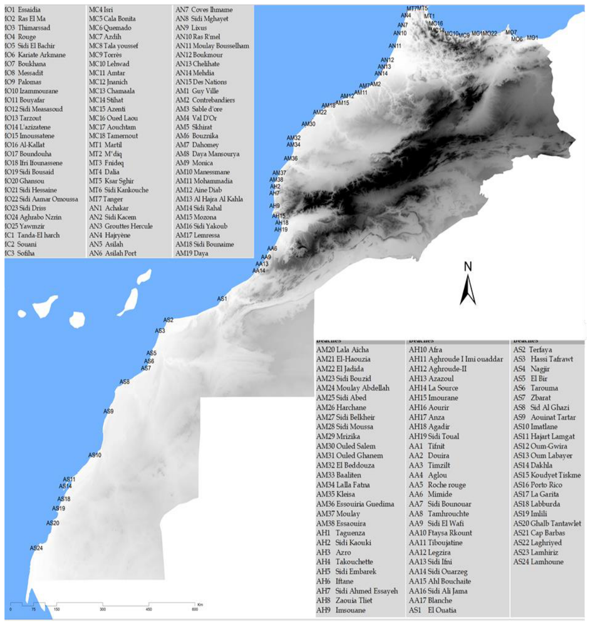
Figure 2.
Criteria for characterizing beaches: field methods.
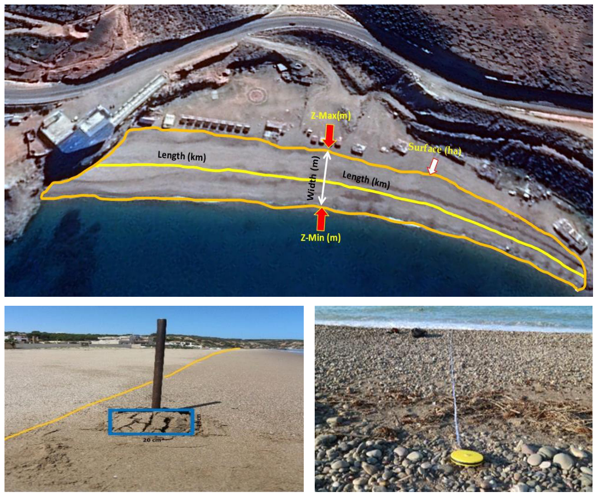
Figure 3.
Decomposition of total inertia into the analysis factors.
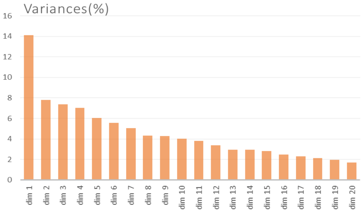
Figure 4.
Distribution of the beaches on the first factorial planes of the CA: F1 × F2 (left) and F3 × F4 (right).
Figure 4.
Distribution of the beaches on the first factorial planes of the CA: F1 × F2 (left) and F3 × F4 (right).
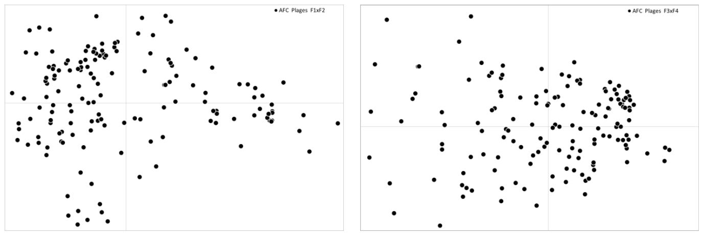
Figure 5.
Contribution of beach descriptors to the CA planes F1xF2 (top) and F3xF4 (bottom).
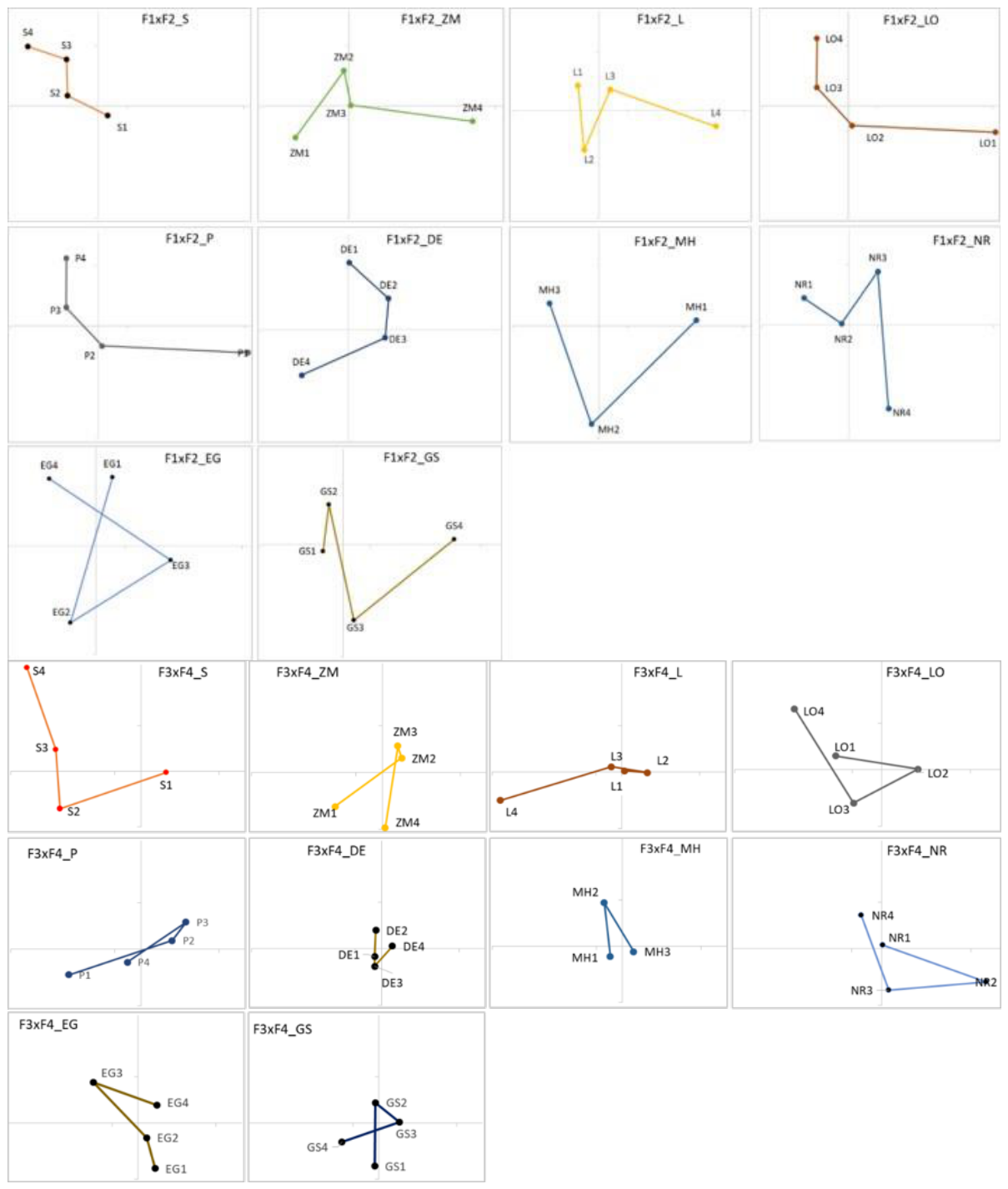
Figure 6.
Representation of the sectors in the F1×F2 (a) and F3×F4 (b) factorial planes.
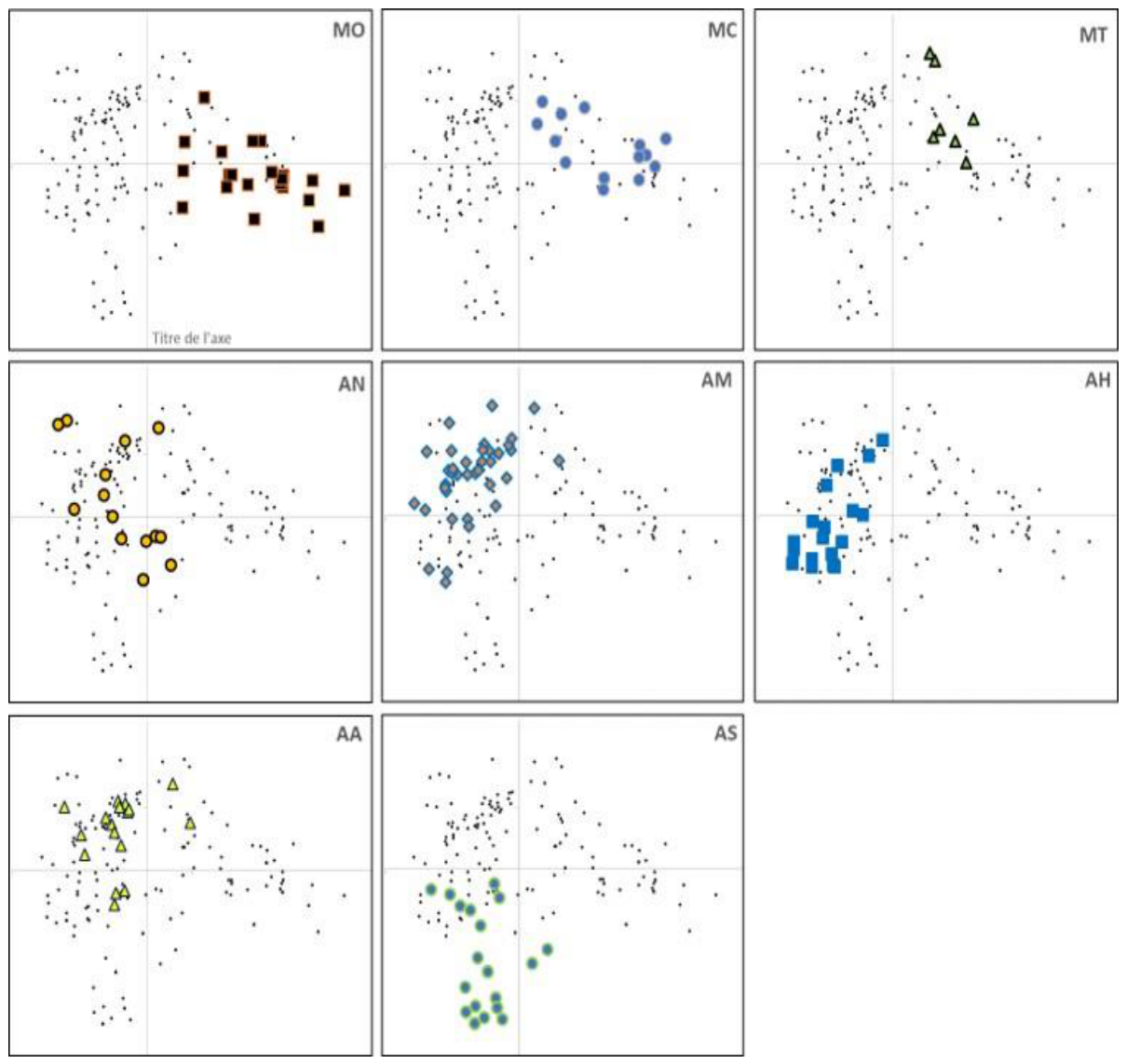
Figure 7.
Classification dendrogram of the 163 Moroccan beaches using a HAC with local and regional physiographic descriptors. The complete dendrogram (top) is subdivided in three zooms (below).
Figure 7.
Classification dendrogram of the 163 Moroccan beaches using a HAC with local and regional physiographic descriptors. The complete dendrogram (top) is subdivided in three zooms (below).
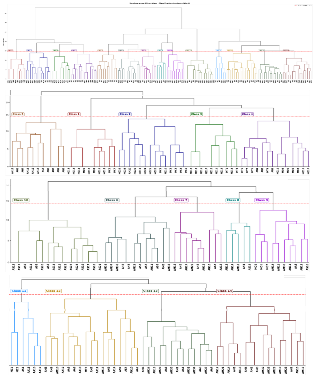
Figure 8.
Classification of Moroccan beaches: projection of the classes obtained using HAC on the F1xF2 (top) and F3xF4 (bottom) planes of CA.
Figure 8.
Classification of Moroccan beaches: projection of the classes obtained using HAC on the F1xF2 (top) and F3xF4 (bottom) planes of CA.
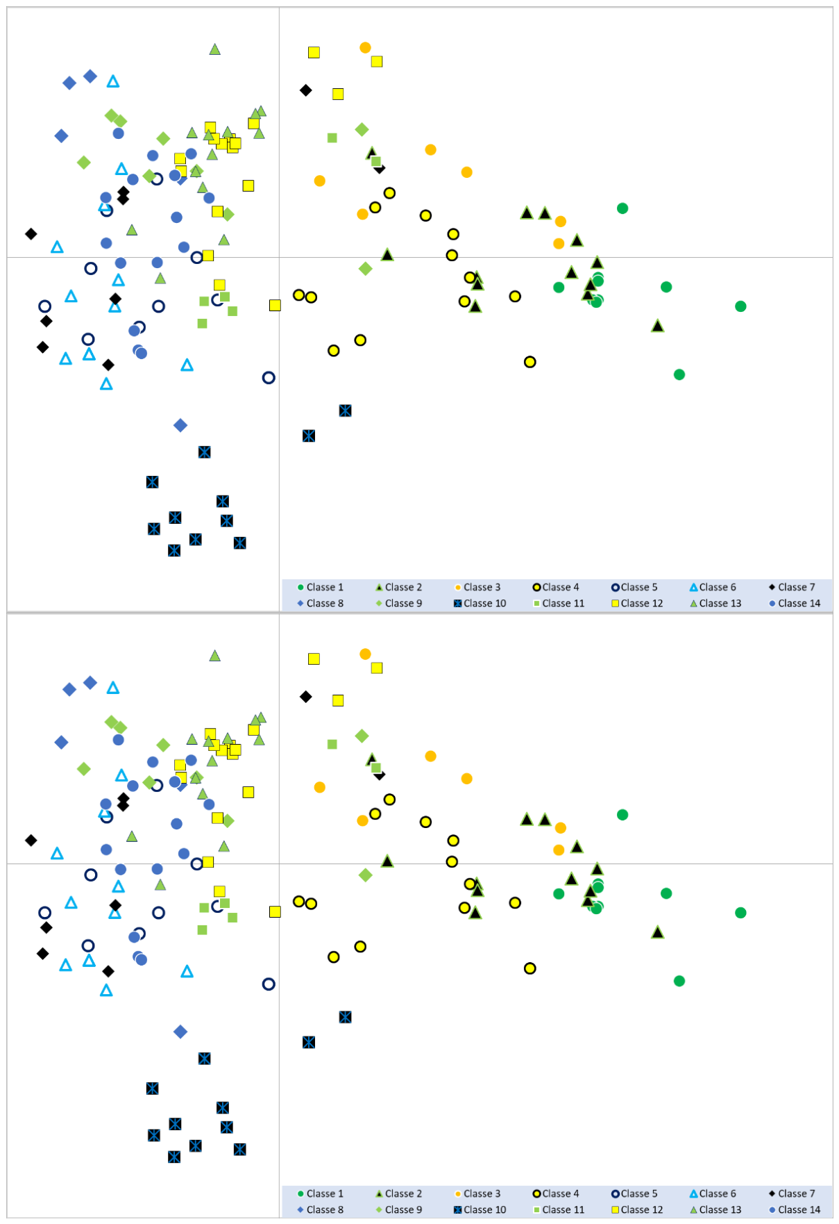
Figure 9.
Classification of Moroccan beaches: projection of class 1 on the F1xF2 (left) and F3xF4 (right) planes of the CA.
Figure 9.
Classification of Moroccan beaches: projection of class 1 on the F1xF2 (left) and F3xF4 (right) planes of the CA.
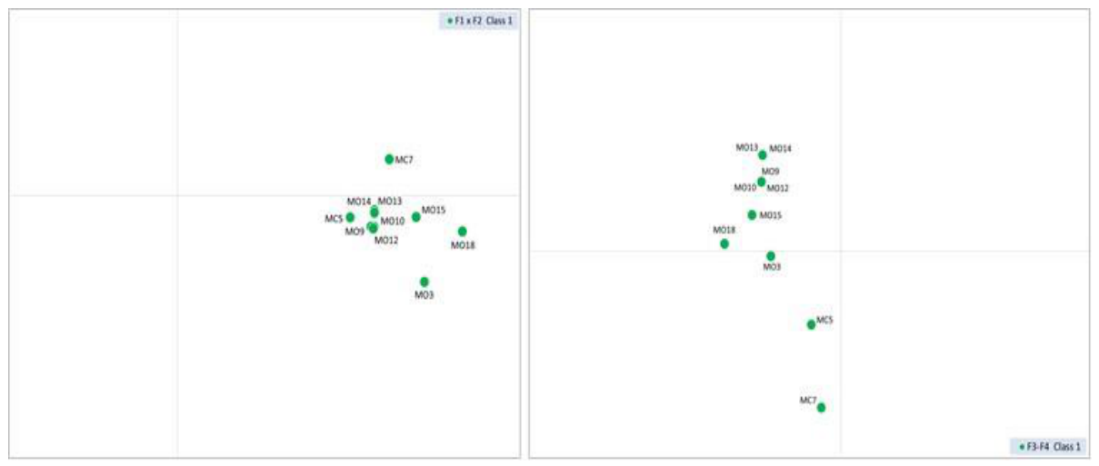
Figure 10.
Classification of Moroccan beaches: projection of class 2 on the F1xF2 (left) and F3xF4 (right) planes of the CA.
Figure 10.
Classification of Moroccan beaches: projection of class 2 on the F1xF2 (left) and F3xF4 (right) planes of the CA.
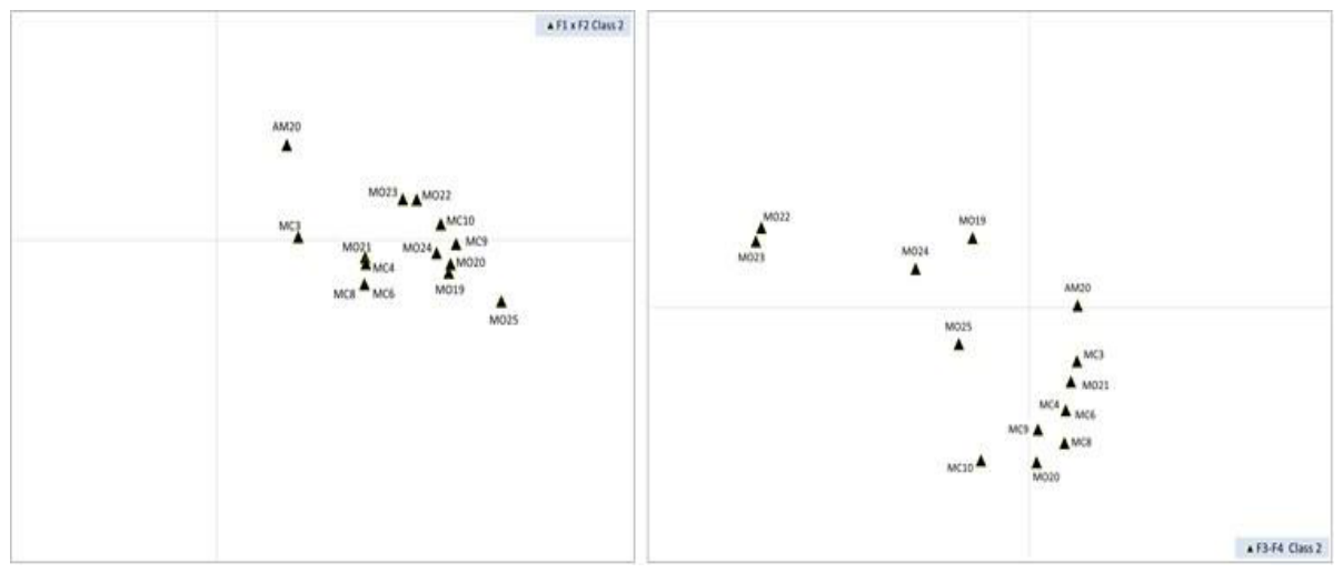
Figure 11.
Classification of Moroccan beaches: projection of class 3 on the F1xF2 (left) and F3xF4 (right) planes of the CA.
Figure 11.
Classification of Moroccan beaches: projection of class 3 on the F1xF2 (left) and F3xF4 (right) planes of the CA.
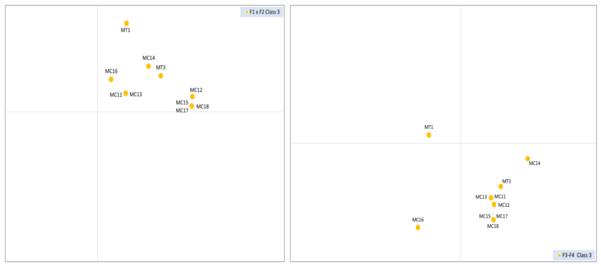
Figure 16.
Classification of Moroccan beaches: projection of class 8 on the F1xF2 (left) and F3xF4 (right) planes of the CA.
Figure 16.
Classification of Moroccan beaches: projection of class 8 on the F1xF2 (left) and F3xF4 (right) planes of the CA.
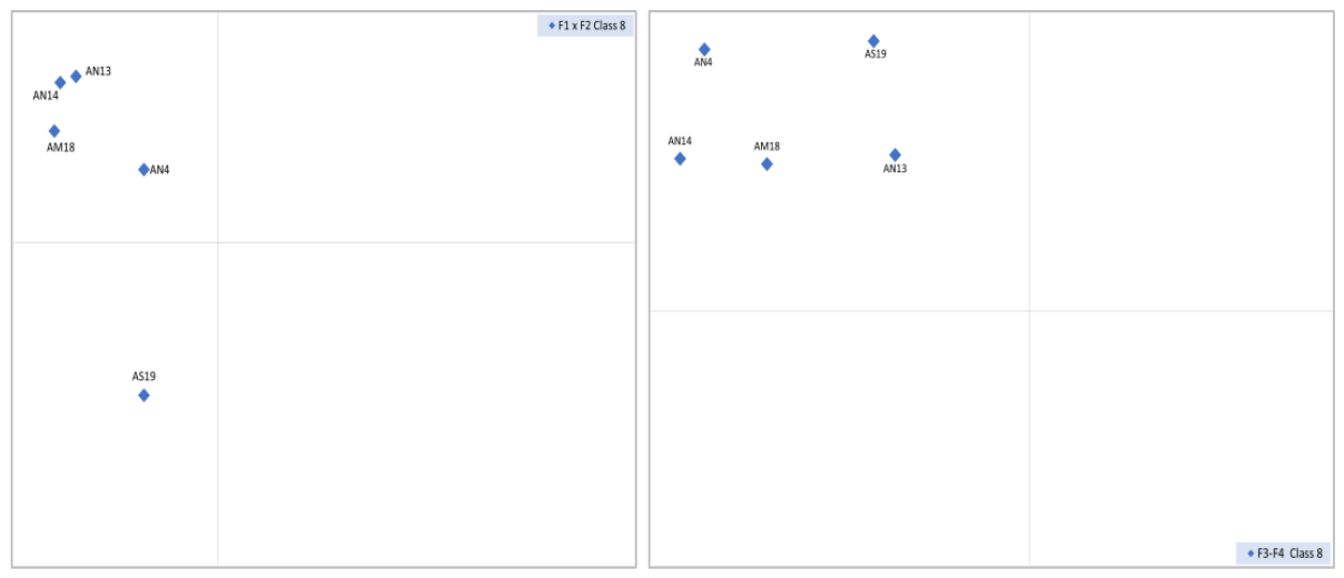
Figure 17.
Classification of Moroccan beaches: projection of class 9 on the F1xF2 (left) and F3xF4 (right) planes of the CA.
Figure 17.
Classification of Moroccan beaches: projection of class 9 on the F1xF2 (left) and F3xF4 (right) planes of the CA.
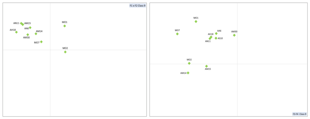
Figure 21.
Classification of Moroccan beaches: projection of class 13 on the F1xF2 (left) and F3xF4 (right) planes of the CA.
Figure 21.
Classification of Moroccan beaches: projection of class 13 on the F1xF2 (left) and F3xF4 (right) planes of the CA.
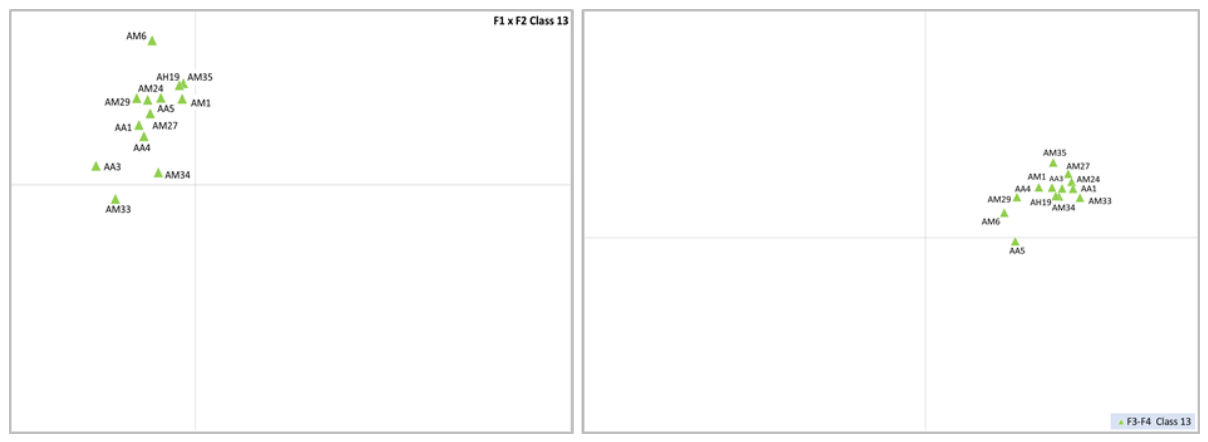
Figure 22.
Classification of Moroccan beaches: projection of class 14 on the F1xF2 (left) and F3xF4 (right) planes of the CA.
Figure 22.
Classification of Moroccan beaches: projection of class 14 on the F1xF2 (left) and F3xF4 (right) planes of the CA.
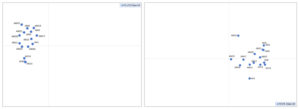

Table 1.
Description of the parameters used in the classification of beaches.
| Beach descriptors | Definition | Methods and tools used | Classes | ||||
|---|---|---|---|---|---|---|---|
| Code | Title | 1 | 2 | 3 | 4 | ||
| S | Area | Beach area (ha) | Area of the delineation polygon, calculated using ArcGIS | <25 | 25-49 | 50-100 | >100 |
| LO | Length | Maximum length parallel to the shoreline (km) | Estimated using Google Earth and measured on-site with a measuring tape | < 0.3 | 0.3-2.4 | 2.5-05 | > 05 |
| DE | Distance to the nearest estuary | Distance between the centre of the beach and the centre of the nearest estuary (km) | <2 | 02-10 | 10-20 | >20 | |
| L | Width | Distance between the extreme tidal lines (m) | <30 | 30-59 | 60-100 | >100 | |
| P | Average slope | Average slope of the beach (%) | Ratio of the beach's height (z max–z min) to its width (based on the boundary polygon) | <3 | 3-7 | 7-14 | >15 |
| MH | Tides | Maximum tide amplitude (m) | Calculated based on data from the website https://www.puertos.es/en-us/oceanografia/Pages/portus.aspx | <1 | 1-2,7 | >2,7 | |
| GS | Sediment size | Median particle size (μm) | Obtained from a sand particle size analysis | ]125-250] | ]250-500] | ]500-1.500] | >1500 |
| NR* | Nature of the rocks | Predominant rock type along the littoral | Compiled from various geological maps at different scales | 1 | 2 | 3 | 4 |
| EG** | Geological era | Geological era of the dominant rocks of the littoral | Compiled from various geological maps at different scales | 1 | 2 | 3 | 4 |
| Z | Beach height | Elevation of the beach relative to sea level or tidal range | Estimated using Google Earth, based on the appearance of the sediments | 01 | 02-03 | 03-04 | >05 |
* 1. Limestone & Calcarenite, 2. Alluvial deposits & Conglomerate, 3. Flysch, Schist, Sandstone, Gneiss, 4. Sandstone marl, Marl. ** 1. Paleozoic & Precambrian, 2. Mesozoic, 3. Cenozoic, 4. Quaternary.
Table 2.
Homogeneous morphological subdivisions (sectors) of Morocco’s coastline.
| Name | Code | Description |
|---|---|---|
| Mediterranean, Oriental | MO | Mediterranean littoral to the Eastern Rif and Lower Moulouya |
| Mediterranean, Central | MC | Mediterranean littoral of the Central Rif |
| Mediterranean, Tingitane Peninsula | MT | Mediterranean littoral of the Western Rif |
| Atlantic, North | AN | Atlantic littoral of Western Rif and the Gharb domains |
| Atlantic, Medium | AM | Atlantic littoral of the Central plateau domain |
| Atlantic, High Atlas | AH | Atlantic littoral of the High Atlas domain |
| Atlantic, Anti-Atlas | AA | Atlantic littoral of the Anti-Atlas domain |
| Atlantic, Sahara | AS | Atlantic littoral of the Sahara domain |
Table 3.
A dichotomous key of the Moroccan beaches, based on five local descriptors (slope, dimensions, tidal range, and sand grain size).
Table 3.
A dichotomous key of the Moroccan beaches, based on five local descriptors (slope, dimensions, tidal range, and sand grain size).
| 1. Steeply inclined beaches with low tidal range, generally narrow (classes 1-4) 1.1. Steeply inclined beaches, with low tidal range and coarse sediments (classes 1-3) 1.2. Steeply inclined beaches, with low tidal range and fine sediments (class 4) 2. Gently-sloping beaches with strong to moderate tidal range, of varying sizes (classes 5-14) 2.1. Gently-sloping beaches, with strong to moderate tidal range, fine to medium sediments, narrow (classes 10–14) 2.2. Gently-sloping beaches, with strong to moderate tidal range, fine to medium sediments, and moderate to wide width (classes 5-9) 2.2.1. Short to medium-length beaches (classes 5-7) 2.2.2. Long beaches (classes 8–9) |
Disclaimer/Publisher’s Note: The statements, opinions and data contained in all publications are solely those of the individual author(s) and contributor(s) and not of MDPI and/or the editor(s). MDPI and/or the editor(s) disclaim responsibility for any injury to people or property resulting from any ideas, methods, instructions or products referred to in the content. |
© 2026 by the authors. Licensee MDPI, Basel, Switzerland. This article is an open access article distributed under the terms and conditions of the Creative Commons Attribution (CC BY) license (http://creativecommons.org/licenses/by/4.0/).
Copyright: This open access article is published under a Creative Commons CC BY 4.0 license, which permit the free download, distribution, and reuse, provided that the author and preprint are cited in any reuse.


