

Submitted:
02 July 2026
Posted:
02 July 2026
You are already at the latest version
Abstract
Wildfire risks are increasing due to climate change, which poses a challenge to conventional firefighting strategies. In the wildland–urban interface (WUI), people and their infrastructure are increasingly vulnerable to fire. Strategic planting of low-flammable vegetation as green firebreaks has emerged to support wildfire management in the WUI. However, under extreme heat and drought, even low-flammability plants become fuel, contributing to fire spread and intensity. This paper presents a conceptual design framework for irrigated green firebreaks (iGFBs), which integrate vegetation design with supplemental irrigation to maintain fuel moisture and enhance fire-regulating ecosystem services. The framework is structured around landscape contexts, priority ecosystem services, integrated design solutions, and implementation considerations. A case study in Noosa Shire, Queensland, Australia, demonstrates how urban water reuse, including greywater and rainwater, can provide the needed irrigation in a WUI landscape. The iGFB concept highlights the potential to reduce fire intensity and slow fire spread while delivering co-benefits such as localised cooling and enhanced biodiversity. While the framework is site-responsive, its underlying principles are transferable to other WUI settings. Further research is required to evaluate the effectiveness of iGFBs under different fire and climate scenarios.
Keywords:
irrigated green fire-break (iGFB)
; wildland urban interface (WUI)
; green firebreak (GFB)
; green infrastructure
; fire regulating ecosystem service
; emerging technologies
1. Introduction
Wildfire disasters are increasing as climate change amplifies fire frequency, intensity, unpredictability, and the potential for human impact [1]. Lives and assets are particularly at risk as human development in the wildland–urban interface (WUI) and fire-prone landscapes increasingly overlap [2,3,4]. Globally, 10% of all fires account for 78% of all fatalities, and most of these occur where natural areas meet human development [5]. As the climate continues to get hotter and drier, current approaches to fire management will be placed under increased pressure, and the human cost may escalate.
Despite increasing investments in technology, including software packages that improve wildfire prediction [6], there are fundamental limits to the effectiveness of suppression of high-intensity wildfires [7]. The Palisades and Eaton fires in the USA, for example, occurred outside the normal fire season and caught people by surprise, which slowed evacuations, resulting in tragic losses of life and homes [8]. Australia’s Black Summer fires of 2019/20 were not unexpected [9,10,11], but considering the catastrophic losses, preparations were inadequate. As fire behaviour exceeds historical thresholds, there is increasing recognition of the need for complementary and proactive mitigation strategies that operate at the landscape scale.
Green firebreaks (GFBs) are one proactive approach to wildfire mitigation that involves strategic placement of low flammability species, ecosystems, or land uses to reduce fire spread and increase suppressibility [12]. GFBs, in various forms, have emerged as an aesthetically integrated wildfire mitigation strategy that when effectively designed, reduce fireline intensity, intercepts embers, and increases time for evacuation and suppression [12,13]. Under extreme drought and heat, even traditional moist or fire-retardant vegetation, such as a riparian rainforest, can ignite [14].
Drought stress and high ambient temperatures not only increase flammability but may undermine the very principle of “green” firebreaks, for which maintaining high live fuel moisture content is critical [15]. This simple observation suggests the potential benefits of proactive water management for GFBs but while both vegetation-based fire mitigation and urban water reuse have been widely studied [12], limited research has explored their integration as a coordinated strategy for wildfire risk reduction.
This paper proposes a conceptual design framework for irrigated green firebreaks (iGFBs), which integrate vegetation planning with supplemental irrigation to maintain fuel moisture and enhance fire-mitigating functions under extreme weather conditions. In doing so, iGFBs are positioned as a form of designed urban vegetation system that can contribute to multi-hazard resilience in the WUI, including wildfire risk, heat stress, and drought impacts. This iGFB framework is illustrated by the specific biophysical and planning context of Noosa Shire, Queensland, Australia, a residential community embedded in natural vegetation.
The next section provides background on the WUI, GFB principles, and the rationale for integrating irrigation into fire mitigation. Subsequent sections introduce the iGFB conceptual framework and its application in a practical setting using the Noosa case study. While not prescriptive, by integrating landscape design, urban water reuse, and ecosystem service principles, the framework provides a foundation for future research, adaptive management, nature-positive hazard mitigation, and community-level shared responsibility.
2. Conceptual Background
2.1. The Wildland-Urban Interface
The Wildland-Urban Interface (WUI), where human development directly borders natural or semi-natural vegetation, is expanding globally due to urban growth, sprawl, and the appeal of forest-adjacent living [16,17]. This expansion is increasing exposure to wildfire, as more people and infrastructure are located within fire-prone landscapes. For example, from 1990-2020, 45% of all new homes in California were built where suburbs meet flammable ecosystems [18]. In Australia, outer-suburban populations have rapidly increased, with nearly 7 million people now living in suburbs in close to what is locally known as ‘bushland’ [5]. Houses within 700 m of bushland are far more likely to be destroyed by fire, especially when built close to other houses [19].
There is no universally accepted definition of the WUI, with overlapping terms such as “Rural Urban Interface” [22] or “Urban Bush Interface” [23], urban fringe or peri-urban areas often used interchangeably. This paper adopts the US Fire Administration Board description of the WUI as the line, area, or zone where structures and other human development meet or intermingle with undeveloped wildland or vegetation fuels [20]. Despite decades of fire research, the WUI remains a challenging zone for fire management due to its complex mix of flammable vegetation, variable topography, fragmented governance, high-value assets, and variable uses.
As the WUI expands, so too do risks to lives and property. In Australia, approximately 78% of wildfire-related fatalities occurred within 30 m of forested vegetation [21]. South-eastern Australia, in particular, is recognised for its high WUI exposure due to flammable vegetation, climate conditions, and urban growth patterns [22]. This risk stems from a combination of spatial planning decisions, proximity of flammable vegetation to buildings, limited hazard reduction, and variable resident preparedness or evacuation behaviour [23]. Spatial planning remains one of the least developed tools in fire-risk reduction [24], and continuing expansion of WUI further compounds the risks [25].
As climate change increases the frequency of extreme heat and drought, the WUI faces escalating fire disaster risk, creating an increasingly urgent need for interventions. Proactive design approaches are needed to complement existing fire suppression and evacuation protocols. One such approach to enhance preparedness by mitigating fire in the WUI is the use of irrigated GFBs.
2.2. Irrigated Green Firebreaks
Green firebreaks (GFBs) are inconsistently defined in the literature but typically associated with zones of strategically placed, less-flammable vegetation or systems that are proactively designed to reduce wildfire spread, flame height, and fireline intensity [12]. In addition to fire mitigation, GFBs can deliver co-benefits, including carbon sequestration and biodiversity [26], but more empirical testing is needed [27], particularly under future climatic considerations. Most existing GFB applications rely on passive vegetation selection and natural rainfall, with limited consideration of active water management.
Urban vegetation has been widely studied for its role in moderating microclimates and mitigating urban heat island (UHI) effects. While urban greening provides cooling through evaporation and shading [28], as temperatures rise and drought conditions intensify, even vegetation typically considered low-flammability may become more likely to burn [29]. Urbanisation intensifies heatwaves and associated wildfire risk [30]. Heatwaves pose a greater hazard to people than fire; however, the potential for urban greenery to provide cooling is tempered by concerns about flammability and fire risk.
Vegetation moisture content is one of the strongest determinants of flammability. As fuel moisture increases, ignition probability decreases, as do rates of fire spread and intensity. Ecosystem flammability decreases with higher humidity, higher fuel moisture, and higher fuel decomposition rates [31,32]. Observations from wetter ecosystems, including riparian zones [33], irrigated golf courses [34], and rainforests [14], suggest that moist vegetation slows the spread of fire. This highlights the potential role of irrigation as a deliberate design variable in vegetation-based fire mitigation. Despite this logic, few studies have tested irrigated vegetation systems explicitly for firebreak purposes, and current fire management guidelines rarely recommend proactive water management as a wildfire mitigation strategy.
The concept of irrigated green firebreaks (iGFBs) builds on existing GFB approaches by integrating vegetation design with supplemental irrigation to enhance fire-mitigating functions under extreme climatic conditions. In doing so, iGFBs reposition urban vegetation not only as a passive landscape feature, but as an actively managed system capable of contributing to multi-hazard resilience, including wildfire risk, heat stress, and drought impacts.
3. IGFB Conceptual Design Framework
4. Application of the Framework to a Case Study
To demonstrate how the iGFB framework can be applied, we present a case study for Noosa, Queensland. This location was selected based on its high wildfire risk, WUI landscape characteristics, availability of treated water, and commitment to nature-based planning. The iGFB framework is applied in a stepwise manner to assess feasibility and to guide site-specific design interventions, following the logic outlined in Section 3.3.
- Step 1 involves identifying site considerations and key landscape design requirements within the Noosa WUI. The potential for fire disasters in Noosa is increasing due to worsening fire weather and increasing populations in fire-prone WUI settings.
- Step 2 focuses on prioritizing the ecosystem services that the iGFB should deliver in response to these needs, including fire regulating services, which are linked to cooler, moister microclimates, soil moisture and, increased biodiversity, and carbon sequestration.
- Step 3 translates these priorities into design strategies by specifying vegetation types, spatial arrangements, irrigation systems, and integration with fire response infrastructure. This step ensures that the iGFB performs as a multifunctional buffer tailored to site conditions.
- Step 4 considers the broader benefits and implementation feasibility of the iGFB. This includes potential social and environmental co-benefits, integration into planning schemes, and alignment with local infrastructure such as recycled water and bushland reserves.
4.1. Step 1: Landscape Context and Fire Management in Noosa, Queensland
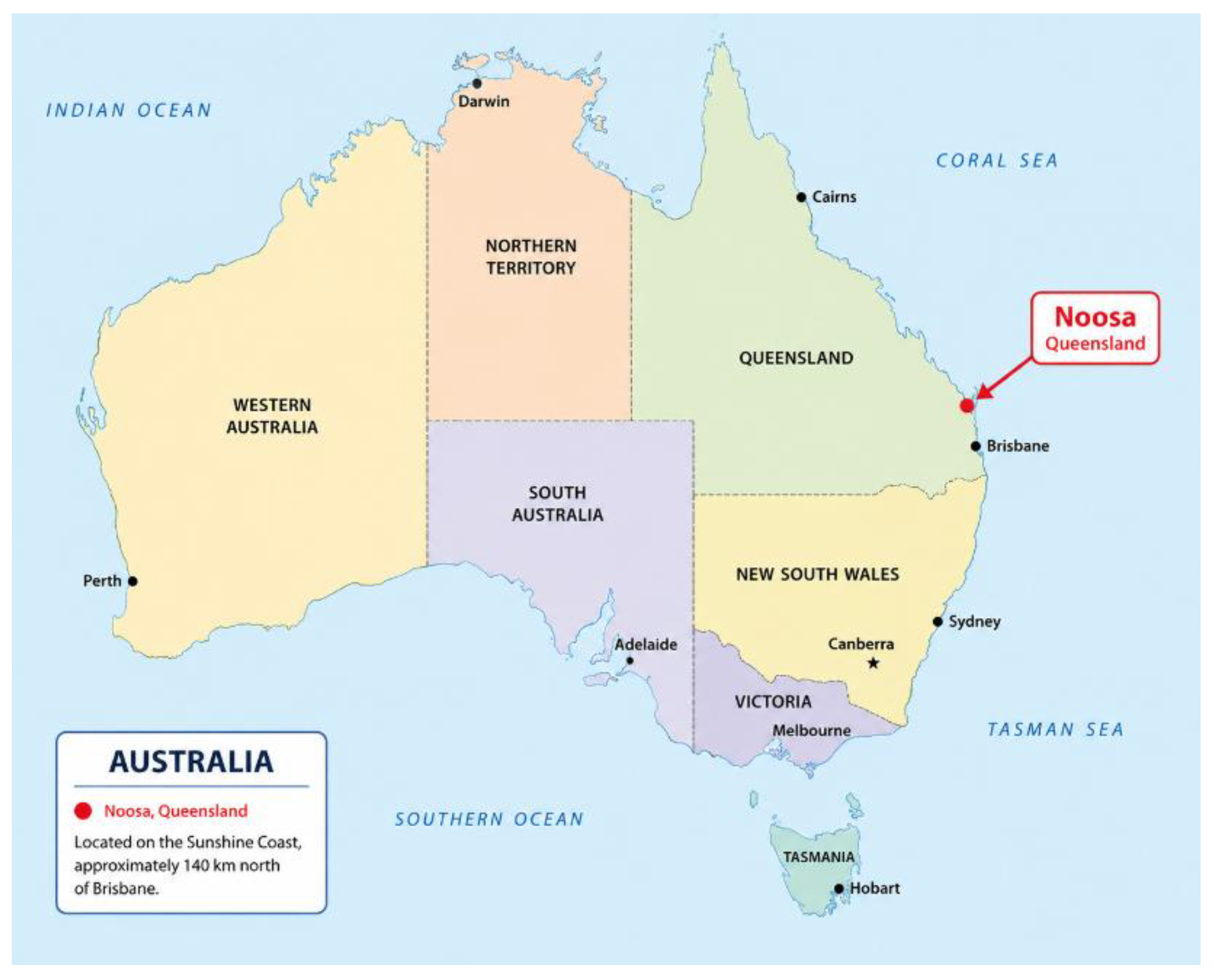
Noosa, located in south-east Queensland, comprises a mix of residential development and extensive natural vegetation, with over 50% of the area classified as WUI (Figure 1) [36]. Climate projections indicate rising temperatures, reduced rainfall, and a growing number of very high to extreme fire danger days, contributing to elevated fire risk [37]. The location is shown in Figure 1, and key geographic, climatic, and ecological characteristics of the study area are summarised in Table 2.
Figure 1.
Noosa is located in Queensland, Australia.
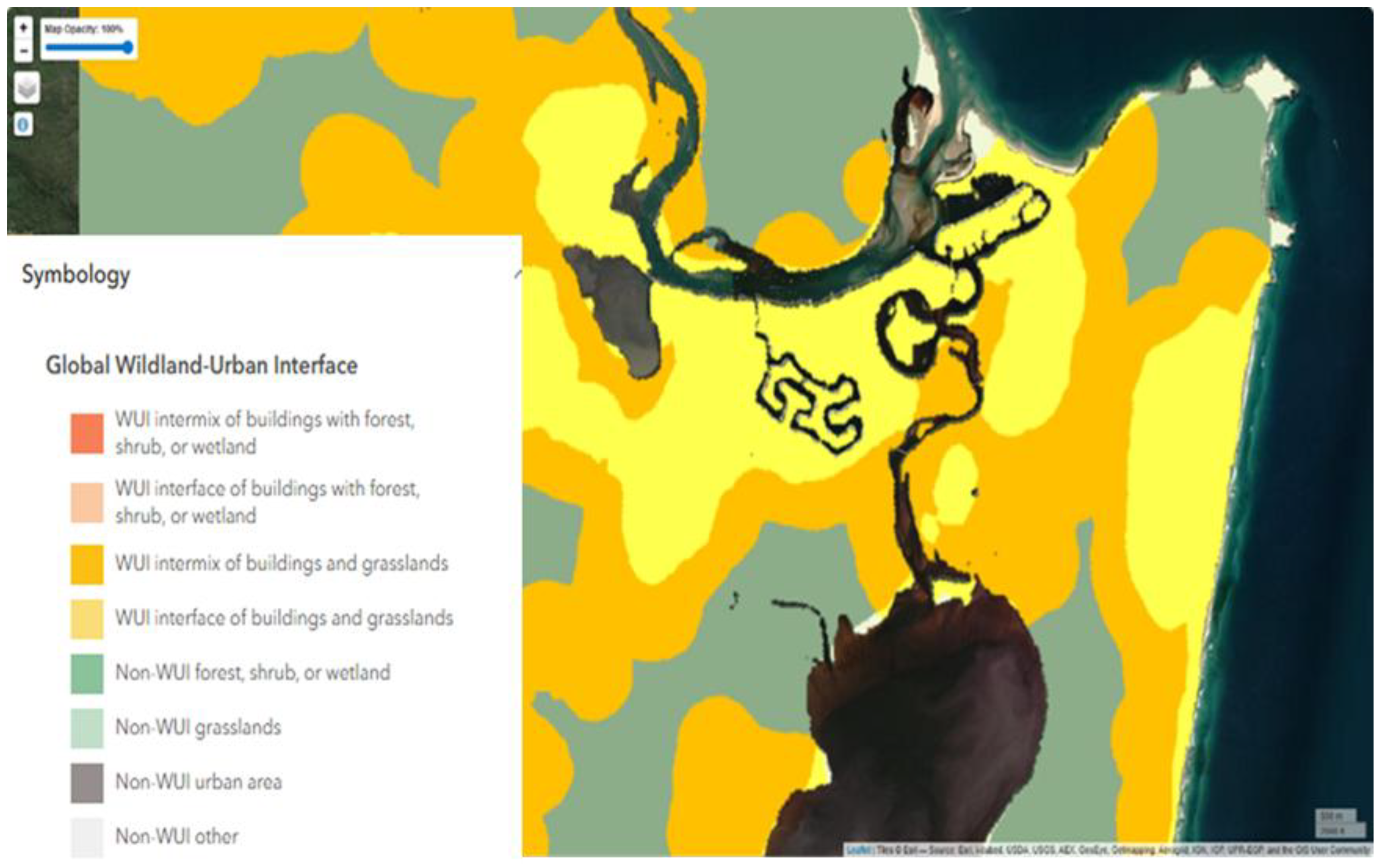
The landscape comprises a diverse mosaic of ecosystems, including fire-prone eucalypt forests and heathlands alongside less fire-adapted vegetation such as rainforests, wetlands, and melaleuca woodlands [43]. With 42% of Noosa in protected areas [40], there are extensive interfaces between urban development and conservation land [44]. Strict regulations about building height and density limit vertical growth, contributing to outward sprawl and more interfaces between homes and vegetation [45].
Figure 2.
Global Wildland Urban Interface map, highlighting Noosa’s rich interface [46].
Figure 2.
Global Wildland Urban Interface map, highlighting Noosa’s rich interface [46].
Wildfire management in the area currently relies on a combination of asset protection zones, fire access trails, fuel-reduction zones, and planned burns [40]. These approaches are essential components of contemporary fire management. Reportedly, their effectiveness is increasingly constrained by narrowing weather windows for safe burning, droughts [28], particularly during El Niño cycles [47,48], ecological trade-offs, and the potential for fire behaviour to exceed suppression thresholds under extreme conditions [49]. Recent fire events in the region have highlighted the challenges of managing fire in densely vegetated WUI environments.
Noosa Council proactively reduces fuel through weed and bushland management in bushland areas and reserves, with decisions informed by site-specific conditions [40]. Fire or fuel breaks, referred to locally as ‘fire trails’, are used to reduce fuel, thereby reducing the spread of fire [50]. Fire trails, which require regular clearing, can cause ecological and edge effects, alter water flow and increase the amount of solar radiation reaching the ground [51]. Where planned burns are not safe or appropriate, Noosa utilises asset protection zones which have varying fuel-free and fuel-reduced zones, with taller trees retained and the understory and ground cover removed [40].
The combination of diverse vegetation, high conservation value, expanding urban development, and changing fire weather conditions creates a complex fire management environment in which traditional approaches alone may be insufficient. In this context, there is a need for complementary strategies that operate at the landscape scale and integrate fire mitigation with broader ecological and planning objectives. For Noosa, this includes approaches that can reduce fire intensity and spread near residential areas while maintaining ecosystem function and landscape amenity.
These conditions provide a suitable context for exploring iGFBs as a design-based intervention. By integrating vegetation selection, spatial planning, and water management, iGFBs offer a potential means of enhancing resilience in WUI landscapes where conventional fuel reduction and suppression strategies face increasing limitations.
4.2. Step 2: Identification of the Priority Ecosystem Services
Ecosystems provide direct and indirect services for human welfare [52], including climate regulating services which alter temperatures and moisture [53], with the potential to regulate or protect from fire by influencing ignition, spread, and intensity [54]. This section considers services related to fire regulation, through drought mitigation, microclimate enhancement and ember reduction.
The use of ecosystem services to mitigate drought is well accepted [55,56]; and while drought is a critical ingredient for mega-fires, their application to fire mitigation remains poorly researched. Water, particularly fuel and soil moisture, is a key indicator for flammability, and the lack of moisture, particularly drought, is a key ingredient in mega-fire risk [7,57]. Droughts reduce fuel moisture, which in turn can lead to longer fire seasons, with larger, more severe fires, and increased plant mortality [58]. Furthermore, water can reduce the likelihood of ignition and the positive heat feedback that drives fire, and as such, ecosystem services for water regulation may be critical to fire mitigation. Increased evapotranspiration in vegetated ecosystems and canopy shading can provide a cooling effect [59]. The primary function of iGFBs is to proactively mitigate fire by supporting localised drought mitigation and cooling, directly through irrigation, and indirectly through ecosystem services that regulate the microclimate and water.
Microclimate temperature buffering is linked to soil moisture [60] and is directly related to terrestrial ecosystem functioning, supporting biodiversity, nutrient cycling, carbon storage and climate regulation [61]. Drier systems are more likely to burn, and higher soil moisture levels also support decomposition [29], altering fuel dynamics in some ecosystems [62]. Microclimates, within and across ecosystems, can support landscape heterogeneity that can mitigate fire [63] while providing fire refuges [64]. Enhancing ecosystem services and microclimates may support a nature-based solution to mitigate predicted climate extremes, while supporting fire regulation.
Windbreaks or shelterbelts alter winds, while benefiting soil, biodiversity and water balance [65]. Managing ecological processes and structural patterns in the landscape may reduce fire risk while improving ecosystem services and resilience. The iGFB design actively manages the ecosystem to buffer winds and intercept embers with a less flammable microclimate, thereby enhancing fire regulation.
4.3. Step 3: iGFB Design Solutions
4.3.1. Urban Water Reuse Potential for Irrigation
Consistent irrigation is a key consideration in iGFB design, enabling the maintenance of elevated fuel moisture during periods of drought and extreme heat. Australia’s high rainfall variability emphasises the importance of water storage [66], while increasing water demand and declining availability [108], highlight the need for water security strategies for Southeast Queensland [67]. In this context, water-sensitive urban design approaches prioritise decentralised water reuse, including rainwater harvesting, bioretention systems, and greywater reuse. The potential water sources in Noosa’s WUI were considered based on quality, quantity, and consistency, providing the basis for supporting iGFB irrigation.
The quantity of water required for iGFB irrigation is calculated using Queenslands’ State Government-design irrigation rates of 10 mm/m2/week for native vegetation. Based on a conceptual iGFB width of 10 m [12] and an average WUI property frontage of 14m, this equates to an indicative irrigation requirement of approximately 1400 L/m2/week per property-scale iGFB. Water quality and regulatory constraints limit the use of several potential sources. Sewage requires additional treatment and was not considered further, while the public water supply system is of very high quality and, while commonly used for urban garden irrigation, is restricted during droughts [68]. Similarly, extraction from natural waterways or groundwater sources was excluded due to environmental and regulatory considerations.
Decentralised urban water reuse, such as bioretention systems, rainwater tanks, and greywater, was identified as the most viable option. Systems, including bioretention basins and rain gardens, can improve infiltration, reduce peak flows, and enhance water quality [69,70]; however, their ability to provide a consistent irrigation supply during drought is limited. Rainwater tanks are a popular urban strategy for conserving potable water [71], however, their reliability depends on rainfall patterns, storage capacity, and maintenance [72], and uptake is variable across the region.
Greywater represents a more consistent supply source; it includes household water from washing machines, showers and basins, and full systems require additional plumbing and treatment to mitigate potential negative impacts on the environment. As such, the uptake of full greywater systems is limited, but is an active option during drought, as demonstrated during Australia’s Millennium drought when over 50% of households used greywater in some form [73]. In Australia, greywater reuse is regulated by State and Local Government to ensure public health and environmental conditions (soil and climate) are managed; however, it is simpler and less regulated to divert and reuse washing machine water, which makes up over a third of typical households’ greywater.
Noosa Council allows approved greywater for irrigation, so long as the treatment complies with wastewater regulations and is considered fit for purpose [74]. Noosa’s water utility (Unity Water) estimates 165 litres/person/day, with greywater typically accounting for 60% of household wastewater, or 99 litres/person/day. A typical household (2.4 persons) [39] could generate approximately 1,386 L/week. This is broadly comparable to the estimated irrigation demand of a property-scale iGFB, indicating that greywater reuse has the potential to meet a substantial proportion of irrigation requirements.
The consensus on climate change includes heating and drying trends, as well as water scarcity concerns. Most houses continue to be built without considering urban water reuse, including rainwater and greywater, so the full potential remains underutilised. The iGFB irrigation requirements could be met through a combination of rainwater and greywater, but prolonged droughts pose challenges.
4.3.2. Active Vegetation Management
iGFB designs need to be site-specific, responsive to, and guided by existing land types, uses, and management practices. The selected vegetation for IGFBs should be properly maintained, as it is critical to achieving fire-mitigating functions, including the development of a shaded canopy, with moist soil and porous edges to provide wind, and direct-flame protection [12]. Vegetation structure and management play an important role in iGFB design, including managing windbreaks that buffer rather than stop wind, and reduce embers [75].
In the Noosa context, native rainforest vegetation is identified as a suitable candidate for the iGFB design, as they have been re-emerging in WUI bushland reserves [76]. Rainforests are typically fire-sensitive ecosystems, characterised by higher moisture availability, dense canopy cover, and enhanced soil nutrient cycling through decomposition processes [77]. The effectiveness of rainforest-based iGFBs depends on active management to maintain ecosystem health and prevent the establishment of invasive species, such as Lantana camara, which may increase fire risk in rainforests [78]. As such, iGFBs will require active management to reduce the spread of invasive species and enhance ecosystem health by rehabilitating and maintaining less-flammable rainforest for cooler, wetter microclimates with reduced wind to support fire regulation.
4.3.3. iGFB Zonation and Conceptual Design
An important aspect of the iGFB design is to complement existing fire frameworks and spatial planning approaches. Site-specific fire risk and development requirements in bushfire-prone areas should be considered when designing and maintaining iGFBs. In high-risk settings, vegetation-based approaches alone may not be sufficient, reinforcing the need for iGFBs to complement, rather than replace, established fire mitigation strategies.
In Noosa, spatial fire management is typically implemented through asset protection approaches that establish graduated zones around buildings to reduce fuel loads, radiant heat, ember attack, and direct flame exposure [79]. These commonly include a near-structure fuel-reduced or fuel-free zone, followed by managed vegetation areas extending into the surrounding landscape. While the extent and configuration of these zones vary depending on site conditions, they provide a useful foundation for integrating iGFB design.
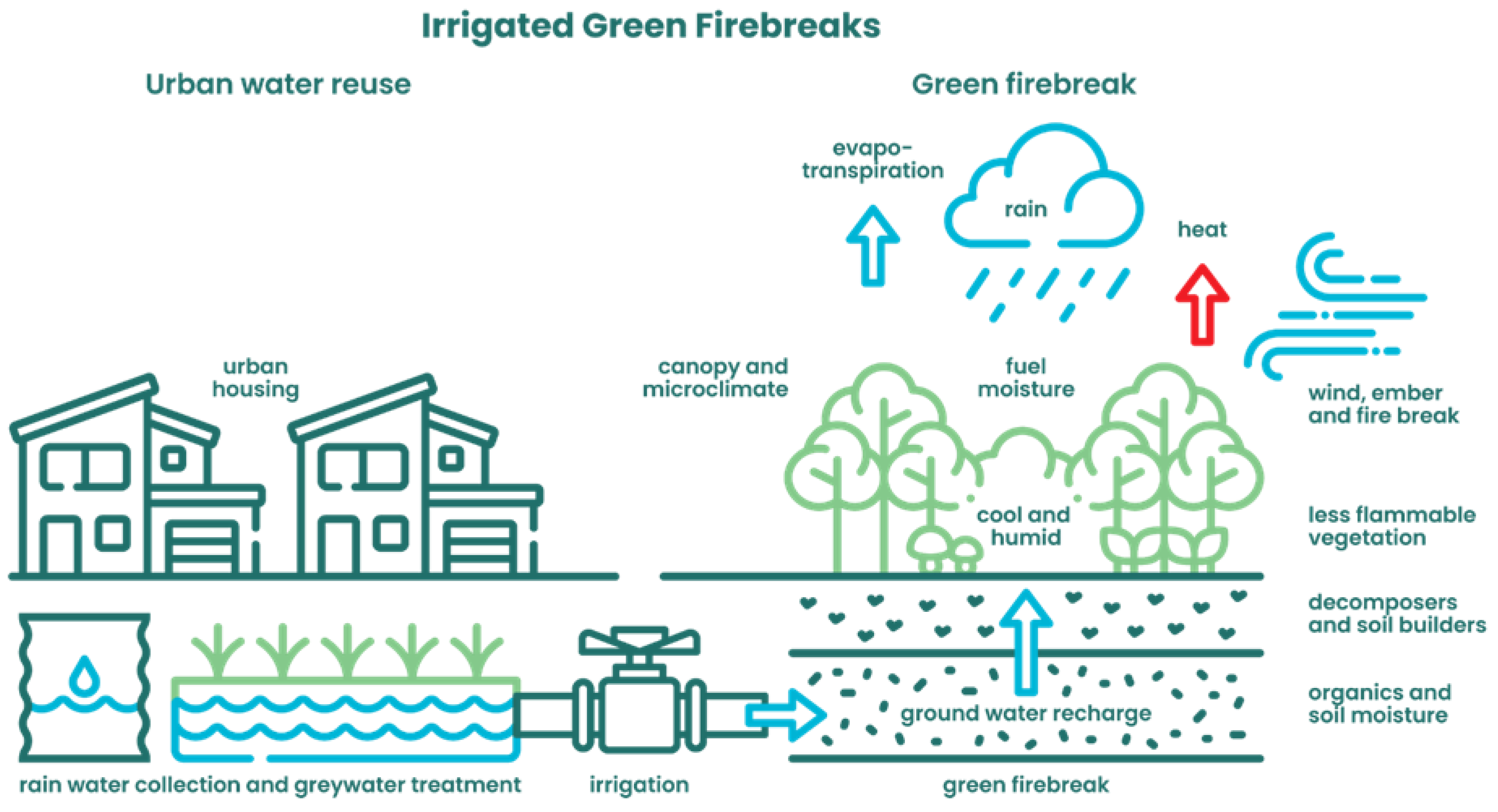
Building on these principles, the iGFB concept (Figure 2) introduces an additional, actively managed vegetation layer within the WUI. A conceptual spatial configuration includes:
- House & garden zone: fuel is removed within 1.5-2m, and open less-flammable vegetation patches are managed up to 10 m from the houses for asset protection and to increase defensible space;
- iGFB – WUI zone (10 m wide by WUI length): urban water is reused to consistently irrigate and actively manage low-flammability vegetation; and
- Transition zone: irrigation tapers off and less flammable plant species are encouraged to blend with adjacent ecosystems; may include access paths for fire service corridors.
These zones are not prescriptions but components that can be adapted to landscape constraints and planning goals, including property size, topography, and planning requirements. In the WUI setting, where land parcels continue to decrease in size, and the potential for house-to-house conflagration increases [80], the effectiveness of iGFBs is likely to depend on coordinated implementation across multiple properties. While the primary role of the iGFB is household fire mitigation, its effectiveness requires integration into a broader urban planning and fire management framework.
Figure 2.
iGFB Conceptual Design: the illustration highlights the potential implementation of an iGFB, in which consistent irrigation from urban water reuse could support GFB vegetation, such as rainforests, in providing fire-regulating services in the WUI.
Figure 2.
iGFB Conceptual Design: the illustration highlights the potential implementation of an iGFB, in which consistent irrigation from urban water reuse could support GFB vegetation, such as rainforests, in providing fire-regulating services in the WUI.
4.4. Step 4: Implementation Potential and Co-Benefits
With hotter, drier conditions contributing to worsening fire weather, there is growing recognition that additional, complementary approaches are needed to enhance wildfire resilience in WUI landscapes. The iGFB concept provides a proactive option, a nature-based intervention that integrates vegetation and water management to influence fire behaviour while delivering broader environmental and social benefits [12]. There is concern that strengthening one ecosystem service could have trade-offs for others [53]. Ultimately, this iGFB approach considers greater potential to deliver positive co-benefits by learning from and working with nature.
The primary justification for iGFBs lies in their potential to modify key drivers of fire behaviour, particularly fuel moisture, microclimate conditions, and wind dynamics. By maintaining cooler, wetter, and less flammable vegetation systems, iGFBs may reduce fire intensity and slow fire spread, thereby increasing the window for evacuation [26] and suppression [81]. While iGFBs are unlikely to prevent structural loss under extreme fire conditions, even marginal reductions in fire intensity and rate of spread can have significant implications for fire management outcomes and community safety.
From an implementation perspective, iGFBs are most suited to WUI settings where access to decentralised water resources, such as greywater and rainwater, can support consistent irrigation. The integration of iGFBs within existing urban landscapes enables their implementation incrementally at the property or neighborhood scale, particularly when aligned with water-sensitive urban design strategies and existing asset protection approaches. However, successful implementation will depend on supportive planning frameworks, regulatory alignment, and ongoing vegetation management.
Beyond wildfire mitigation, iGFBs offer a range of co-benefits that strengthen their value as a landscape intervention [26]. These include localized cooling through evapotranspiration and shading, which can reduce urban heat stress; improved soil function and water retention; enhanced biodiversity through the establishment of more stable and less fire-prone vegetation systems; and opportunities for community engagement in landscape management. In the Noosa case study, the use of rainforest vegetation highlights the potential for iGFBs to contribute to ecological restoration objectives, although species selection must remain site-specific.
The implementation of iGFBs also presents challenges and trade-offs. Water availability may be constrained during prolonged drought, vegetation requires active management to maintain low flammability, and there is currently limited empirical evidence quantifying the effectiveness of irrigated vegetation systems for fire mitigation. In addition, integration with existing fire management practices and planning systems may require institutional adaptation.
Given these uncertainties, further research is needed to evaluate the performance of iGFBs under different fire and climate scenarios. In particular, fire behaviour modelling provides a pathway to test how changes in vegetation structure and fuel moisture influence fire spread and fireline intensity in WUI environments.
Overall, the iGFB framework represents a shift toward more integrated and proactive approaches to wildfire management, where vegetation and water systems are deliberately designed to contribute to hazard mitigation while supporting broader landscape resilience.
5. Conclusion
This paper presents a conceptual framework for irrigated green firebreaks (iGFBs) as a proactive, design-based approach to wildfire risk reduction in WUI landscapes. Wildfire management can be enhanced through landscape context, priority ecosystem services, integrated design solutions, and implementation considerations. By integrating vegetation selection, water management, and spatial planning, the framework demonstrates how maintaining higher fuel moisture and managing vegetation to modify microclimates and wind influence fire behaviour, potentially reducing fire intensity and slowing fire spread near residential areas.
Using Noosa as a case study, the framework illustrates how urban water reuse, including greywater and rainwater, can support the irrigation of vegetation systems designed to deliver fire-regulating ecosystem services. While the specific design is site-dependent, the underlying framework, linking landscape needs to ecosystem services and translating these into spatial and functional design interventions, is transferable to other WUI contexts.
Beyond wildfire mitigation, iGFBs have the potential to contribute to broader landscape resilience through co-benefits such as localised cooling, improved soil and water retention, and enhanced biodiversity. However, the concept remains untested at scale, and its effectiveness will depend on site conditions, water availability, and ongoing vegetation management.
Overall, the iGFB framework provides a foundation for integrating water and vegetation as active design elements in wildfire mitigation, supporting more proactive and multifunctional approaches to managing risk in WUI landscapes. Further research is required to evaluate iGFB performance under different fire regimes, particularly through fire behaviour modelling and field validation.
Author Contributions
Conceptualization, methodology, validation, investigation, resources, data curation, and original draft preparation, JDS.; writing—review and editing, visualization, supervision, and project administration, J.D.S., A.P., F.E.P., and S.V.H. All authors have read and agreed to the published version of the manuscript.
Funding
This research received no external funding. The lead author’s PhD studies were supported by scholarships from the University of the Sunshine Coast and Natural Hazards Research Australia.
Acknowledgments
We acknowledge the past, present, and emerging traditional owners’ management of Country, as well as the important traditional approaches and scientific research that we seek to build upon. We also extend our gratitude to our research colleagues and peers for their ongoing support.
Conflicts of Interest
The authors declare that they have no conflicts of interest.
References
- Cunningham, C.X.; Williamson, G.J.; Bowman, D.M.J.S. Increasing frequency and intensity of the most extreme wildfires on Earth. Nat. Ecol. Evol. 2024, 8, 1420–1425. [Google Scholar] [CrossRef] [PubMed]
- Vacca, P.; Caballero, D.; Pastor, E.; Planas, E. WUI fire risk mitigation in Europe: A performance-based design approach at home-owner level. J. Saf. Sci. Resil. 2020, 1, 97–105. [Google Scholar] [CrossRef]
- Murray, A.T.; Baik, J.; Echeverri Figueroa, V.; Rini, D.; Moritz, M.A.; Roberts, D.A.; Sweeney, S.H.; Carvalho, L.M.V.; Jones, C. Developing effective wildfire risk mitigation plans for the wildland urban interface. Int. J. Appl. Earth Obs. Geoinf. 2023, 124, 103531. [Google Scholar] [CrossRef]
- Teymoor Seydi, S.; Abatzoglou, J.T.; Jones, M.W.; Kolden, C.A.; Filippelli, G.; Hurteau, M.D.; AghaKouchak, A.; Luce, C.H.; Miao, C.; Sadegh, M. Increasing global human exposure to wildland fires despite declining burned area. Science 2025, 389, 826–829. [Google Scholar] [CrossRef] [PubMed]
- When cities burn: could the Los Angeles fires happen here? Climate Council of Australia Ltd. (CCA): Canberra, 2025.
- Bowman, D.M. Detecting, monitoring and foreseeing wildland fire requires similar multiscale viewpoints as meteorology and climatology. Fire 2023, 6, 160. [Google Scholar] [CrossRef]
- Nolan, R.H.; Boer, M.M.; Collins, L.; Resco de Dios, V.; Clarke, H.; Jenkins, M.; Kenny, B.; Bradstock, R.A. Causes and consequences of eastern Australia’s 2019–20 season of mega-fires. Glob. Change Biol. 2020, 26, 1039–1041. [Google Scholar] [CrossRef] [PubMed]
- Pappas, S. Palisades and Eaton Fires Show Rising Dangers of Fast-Moving Blazes. In Scientific American; 8 January 2025 2025. [Google Scholar]
- Lucas, C.; Hennessy, K.; Mills, G.A.; Bathols, J. Bushfire Weather in Southeast Australia: Recent Trends and Projected Climate Change Impacts; Climate Institute of Australia: Canberra, September 2007. [Google Scholar]
- Canadell, J.G.; Meyer, C.P.M.; Cook, G.D.; Dowdy, A.; Briggs, P.R.; Knauer, J.; Pepler, A.; Haverd, V. Multi-decadal increase of forest burned area in Australia is linked to climate change. Nat. Commuinications 2021, 12, 1–11. [Google Scholar] [CrossRef] [PubMed]
- IPCC: Part B: Regional Aspects. Contribution of Working Group II to the Fifth Assessment Report of the Intergovernmental Panel on Climate Change - Australasia. Intergovernmental Panel on Climate Change (IPCC), 2014.
- Smith, J.D.; Putz, F.E.; Van Holsbeeck, S. Green Firebreaks: Potential to Proactively Complement Wildfire Management. Fire 2025, 8, 352. [Google Scholar] [CrossRef]
- Penman, S.H.; Price, O.F.; Penman, T.D.; Bradstock, R.A. The role of defensible space on the likelihood of house impact from wildfires in forested landscapes of south eastern Australia. Int. J. Wildland Fire 2018, 28, 4–14. [Google Scholar] [CrossRef]
- Styger, J. Predicting fire in rainforest; University of Tasmania: Hobart, 2014. [Google Scholar]
- Souza, M.L.A. Low Flammability Plants Of The Cerrado For Green Fire Break. BioBrasil 2020, 10. [Google Scholar] [CrossRef]
- Lichter, D.T.; Brown, D.L.; Parisi, D. The rural–urban interface: Rural and small town growth at the metropolitan fringe. Popul. Space Place 2021, 27, e2415. [Google Scholar] [CrossRef]
- Choy, D.L.; Sutherland, C. A changing peri-urban demographic landscape. Aust. Plan. 2008, 45, 24–25. [Google Scholar] [CrossRef]
- Christopher, B. Why California keeps putting homes where fires burn. In CalMatters; 2025. [Google Scholar]
- Chen, K.; McAneney, J. Quantifying bushfire penetration into urban areas in Australia. Geophys. Res. Lett. 2004, 31. [Google Scholar] [CrossRef]
- Memorandum 19-004; Federal Wildland Fire Policy Terms and Definitions. Fire Management Board: Washington, 2019.
- Blanchi, R.; Leonard, J.; Haynes, K.; Opie, K.; James, M.; Kilinc, M.; Dimer de Oliveira, F.; Van den Hornet, R. Life and house loss database description and analysis; CSIRO, Bushfire CRC report to the Attorney-General’s.
- CSIRO EP-129645; Department. 2012.
- Chuvieco, E.; Martínez, S.; Román, M.V.; Hantson, S.; Pettinari, M.L. Integration of ecological and socio-economic factors to assess global vulnerability to wildfire. 2014, 23, 245–258. [Google Scholar] [CrossRef]
- Homer, J. How to build wildfire-resistant communities in a warming world. The Conversation, 25 February 2022. [Google Scholar]
- Gonzalez-Mathiesen, C.; Ruane, S.; March, A. Integrating wildfire risk management and spatial planning – A historical review of two Australian planning systems. Int. J. Disaster Risk Reduct. 2021, 53, 101984. [Google Scholar] [CrossRef]
- Penney, G.; Habibi, D.; Cattani, M.; Richardson, S. A HANDBOOK OF WILDFIRE ENGINEERING Guidance for wildfire suppression and resilient urban design. 2020, 1.1. [Google Scholar] [CrossRef]
- Marshall, E.; Holyland, B.; Parkins, K.; Raulings, E.; Good, M.K.; Swan, M.; Bennett, L.T.; Penman, T.D. Can green firebreaks help balance biodiversity, carbon storage and wildfire risk? J. Environ. Manag. 2024, 369, 122183. [Google Scholar] [CrossRef] [PubMed]
- Curran, T.J.; Perry, G.L.W.; Wyse, S.V.; Alam, M.A. Managing fire and biodiversity in the wildland-urban interface: A role for green firebreaks. Fire 2018, 1, 1–3. [Google Scholar] [CrossRef]
- Erell, E.; Zhou, B. The effect of increasing surface cover vegetation on urban microclimate and energy demand for building heating and cooling. Build. Environ. 2022, 213, 108867. [Google Scholar] [CrossRef]
- Grootemaat, S.; Wright, I.J.; van Bodegom, P.M.; Cornelissen, J.H.C.; Cornwell, W.K. Burn or rot: Leaf traits explain why flammability and decomposability are decoupled across species. Funct. Ecol. 2015, 29, 1486–1497. [Google Scholar] [CrossRef]
- Eugenio Pappalardo, S.; Zanetti, C.; Todeschi, V. Mapping urban heat islands and heat-related risk during heat waves from a climate justice perspective: A case study in the municipality of Padua (Italy) for inclusive adaptation policies. Landsc. Urban Plan. 2023, 238, 104831. [Google Scholar] [CrossRef]
- Hoffmann, W.A.; Geiger, E.L.; Gotsch, S.G.; Rossatto, D.R.; Silva, L.C.; Lau, O.L.; Haridasan, M.; Franco, A.C. Ecological thresholds at the savanna-forest boundary: how plant traits, resources and fire govern the distribution of tropical biomes. Ecol. Lett. 2012, 15, 759–768. [Google Scholar] [CrossRef] [PubMed]
- Little, J.K.; Prior, L.D.; Williamson, G.J.; Williams, S.E.; Bowman, D.M.J.S. Fire weather risk differs across rain forest—savanna boundaries in the humid tropics of north-eastern Australia. Austral Ecol. 2012, 37, 915–925. [Google Scholar] [CrossRef]
- Pettit, N.E.; Naiman, R.J. Fire in the riparian zone: characteristics and ecological consequences. Ecosystems 2007, 10, 673–687. [Google Scholar] [CrossRef]
- Herbert, C.; Butsic, V. Assessing the Effectiveness of Green Landscape Buffers to Reduce Fire Severity and Limit Fire Spread in California: Case Study of Golf Courses. Fire 2022, 5, 44. [Google Scholar] [CrossRef]
- Semeraro, T.; Aretano, R.; Barca, A.; Pomes, A.; Del Giudice, C.; Gatto, E.; Lenucci, M.; Buccolieri, R.; Emmanuel, R.; Gao, Z.; et al. A Conceptual Framework to Design Green Infrastructure: Ecosystem Services as an Opportunity for Creating Shared Value in Ground Photovoltaic Systems. Land 2020, 9, 238. [Google Scholar] [CrossRef]
- Schug, F.; Bar-Massada, A.; Carlson, A.R.; Cox, H.; Hawbaker, T.J.; Helmers, D.; Hostert, P.; Kaim, D.; Kasraee, N.K.; Martinuzzi, S.; et al. The global wildland–urban interface. Nature 2023, 621, 94–99. [Google Scholar] [CrossRef] [PubMed]
- Special Climate Statement 71—severe fire weather conditions in southeast Queensland and northeast New South Wales in September 2019; Bureau of Meteorology: Melbourne, Australia, 1 November 2021 2019.
- About the Kabi Kabi Native Title determination; Department of Natural Resources and Mines, Manufacturing and Regional and Rural Development (DNR&M): Brisbane, 2025.
- Noosa Shire Council community profile; Australian Bureau of Statistics - Informed Decisions id: Canberra, 2024.
- Noosa Bushland Reserve Strategic Fire Management Plan 2021; Noosa Council: Noosa, 6 2021.
- Summary statistics Sunshine Coast Airport; Bureau of Meteorology: Canberra, 20 November 2025.
- Summers, P. Bushfire Hazard Planning in Noosa Shire - A Planning Scheme Review Project; 1995. [Google Scholar]
- Fisher, L.; Bruton, M.; Walton, M.; Appleby, L. Noosa Biodiversity Plan: Biodiversity Assessment Report; Noosa Council: Noosa, 5 December 2016. [Google Scholar]
- Noosa Area Park Draft Resource Information 2021; Queensland Government Brisbane, 2021.
- Corporate Plan 2016-2036 - Noosa Shire - different by nature. Noosa Council: Noosa, 2016.
- Schug, F.; Bar-Massada, A.; Carlson, A.R.; Cox, H.; Hawbaker, T.J.; Helmers, D.; Hostert, P.; Kaim, D.; Kasraee, N.K.; Martinuzzi, S.; et al. Map of the Global Wildland-urban Interface. 1.1. Zenodo 2023. [Google Scholar] [CrossRef]
- Burton, C.; Betts, R.A.; Jones, C.D.; Feldpausch, T.R.; Cardoso, M.; Anderson, L.O. El Niño Driven Changes in Global Fire 2015/16. Front. Earth Sci. 2020, 8–2020. [Google Scholar] [CrossRef]
- Hu, Y.; Yue, X.; Tian, C. Impacts of El Niño–Southern Oscillation on global fire PM2.5 during 2000–2023. Atmos. Ocean. Sci. Lett. 2025, 18, 100597. [Google Scholar] [CrossRef]
- Meiklejohn, A.M.; Olds, J.A.; Laidlaw, M.J.; Levy, S.; Midtaune, K.; Lawton, C. Post-fire Assessment Report – Natural Values: 2019 bushfire, Great Sandy and Noosa National Parks, South East Queensland Bioregion. 2020.
- Agee, J.K.; Skinner, C.N. Basic principles of forest fuel reduction treatments. For. Ecol. Manag. 2005, 211, 83–96. [Google Scholar] [CrossRef]
- Krix, D.W.; Hingee, M.C.; Martin, L.J.; Phillips, M.L.; Murray, B.R. Ecological Impacts of Fire Trails on Plant Assemblages in Edge Habitat Adjacent to Trails. Fire Ecol. 2017, 13, 95–119. [Google Scholar] [CrossRef]
- Fisher, B.; Turner, R.K.; Morling, P. Defining and classifying ecosystem services for decision making. Ecol. Econ. 2009, 68, 643–653. [Google Scholar] [CrossRef]
- Smith, P.; Ashmore, M.; Black, H.; Burgess, P.; Evans, C.; Quine, T.; Thomson, A.; Hicks, K.; Orr, H. REVIEW: The role of ecosystems and their management in regulating climate, and soil, water and air quality. J. Appl. Ecol. 2013, 50. [Google Scholar] [CrossRef]
- Sil, Â.; Fernandes, P.M.; Rodrigues, A.P.; Alonso, J.; Honrado, J.P.; Perera, A.H.; Azevedo, J. Exploring the concept of fire protection ecosystem service in changing forested landscapes. In Proceedings of the Adaptive Management for Forested Lanscapes in Transformation, Argentina, 1 - 5 October, 2018; p. 1. [Google Scholar]
- Peng, Y.; Chen, L.; Tian, J.; Sun, B.; Jiang, C.; Lu, Y.; Shang, J. Ecosystem services help alleviate the intensity of dryness/wetness. Glob. Ecol. Conserv. 2021, 27, e01581. [Google Scholar] [CrossRef]
- Orimoloye, I.R.; Zhou, L.; M. Kalumba, A. Drought Disaster Risk Adaptation through Ecosystem Services-Based Solutions: Way Forward for South Africa. Sustainability 2021, 13, 4132. [Google Scholar] [CrossRef]
- Ghasemiazma, F.; Tonini, M.; Fiorucci, P.; Turco, M. Megafires in Mediterranean Europe: the compound role of fire weather and drought. npj Nat. Hazards 2026, 3, 33. [Google Scholar] [CrossRef]
- Collins, L.; Clarke, H.; Clarke, M.F.; McColl Gausden, S.C.; Nolan, R.H.; Penman, T.; Bradstock, R. Warmer and drier conditions have increased the potential for large and severe fire seasons across south-eastern Australia. Glob. Ecol. Biogeogr. 2022, 31, 1933–1948. [Google Scholar] [CrossRef]
- Jiao, M.; Jenerette, G.D.; Zhou, W.; Wang, J.; Zheng, Z. Adaptive shading: How microclimates and surface types amplify tree cooling effects? Urban For. Urban Green. 2024, 101, 128546. [Google Scholar] [CrossRef]
- Greiser, C.; Hederová, L.; Vico, G.; Wild, J.; Macek, M.; Kopecký, M. Higher soil moisture increases microclimate temperature buffering in temperate broadleaf forests. Agric. For. Meteorol. 2024, 345, 109828. [Google Scholar] [CrossRef]
- Bravo, A.S.; Camps, S.P.; Pérez, M.Á.V.; Arvide, M.G.T. Soil ecosystem services valuation in a priority terrestrial region for biodiversity conservation in Mexico, from ecological economics and the local community perspective. Discov. Sustain. 2024, 5, 457. [Google Scholar] [CrossRef]
- Little, K.; Graham, L.J.; Flannigan, M.; Belcher, C.M.; Kettridge, N. Landscape controls on fuel moisture variability in fire-prone heathland and peatland landscapes. Fire Ecol. 2024, 20, 14. [Google Scholar] [CrossRef]
- Russo, L.; Russo, P.; Siettos, C.I. A complex network theory approach for the spatial distribution of fire breaks in heterogeneous forest landscapes for the control of wildland fires. PLoS ONE 2016, 11, e0163226. [Google Scholar] [CrossRef] [PubMed]
- Robinson, N.M.; Leonard, S.W.J.; Ritchie, E.G.; Bassett, M.; Chia, E.K.; Buckingham, S.; et al. REVIEW: Refuges for fauna in fire-prone landscapes: Their ecological function and importance. 2013, 50, 1321–1329. [Google Scholar] [CrossRef]
- Weninger, T.; Scheper, S.; Lackóová, L.; Kitzler, B.; Gartner, K.; King, N.W.; Cornelis, W.; Strauss, P.; Michel, K. Ecosystem services of tree windbreaks in rural landscapes—a systematic review. Environ. Res. Lett. 2021, 16, 103002. [Google Scholar] [CrossRef]
- Dey, R.; Lewis, S.C.; Arblaster, J.M.; Abram, N.J. A review of past and projected changes in Australia’s rainfall. Wiley Interdiscip. Rev. Clim. Change 2019, 10, e577. [Google Scholar] [CrossRef]
- Teixeira, A.L.d.F.; Bhaduri, A.; Bunn, S.; Souza, S.A.d.; Gonçalves, M.V.C.; Yu, S. Ecosystem and human water security trade-offs in a context of climate change in South East Queensland Region, Australia. Australas. J. Environ. Manag. 2024, 1–19. [Google Scholar]
- Lindsay, J.; Supski, S. Changing household water consumption practices after drought in three Australian cities. Geoforum 2017, 84, 51–58. [Google Scholar] [CrossRef]
- Mangangka, I.R.; Liu, A.; Egodawatta, P.; Goonetilleke, A. Performance characterisation of a stormwater treatment bioretention basin. J. Environ. Manag. 2015, 150, 173–178. [Google Scholar] [CrossRef] [PubMed]
- Davis, A.P.; Hunt, W.F.; Traver, R.G.; Clar, M. Bioretention Technology: Overview of Current Practice and Future Needs. J. Environ. Eng. 2009, 135, 109–117. [Google Scholar] [CrossRef]
- Khastagir, A.; Jayasuriya, N. Optimal sizing of rain water tanks for domestic water conservation. J. Hydrol. 2010, 381, 181–188. [Google Scholar] [CrossRef]
- Zanotto, E.; Senevirathna, L. Maintaining microbial and chemical quality in Australian rainwater tanks: Insights and global advancements. Environ. Chall. 2025, 20, 101190. [Google Scholar] [CrossRef]
- Australia’s Environment: Issues and Trends, 2007; 4613.0; Australian Government: Canberra, 2008.
- Wastewater treatment/Disposal: Domestic Grey-Water Disposal and Re-Use; Noosa Council: Noosa, 2020.
- Ondei, S.; Williamson, G.J.; Foyster, S.; Bowman, D.M. An expert system to quantify wildfire hazards in gardens and create effective defensible space. Int. J. Disaster Risk Reduct. 2025, 121, 105424. [Google Scholar] [CrossRef]
- Noosa Bushland Reserves Strategic Plan 2021-2026; Noosa Council: Noosa, February 2021.
- Burton, J.E.; Penman, T.D.; Peacock, R.J. Fires in rainforests: Quantifying litter bed flammability of cool temperate rainforests in eastern Australia. Am. J. Bot. 2025, e70111. [CrossRef] [PubMed]
- Berry, Z.C.; Wevill, K.; Curran, T.J. The invasive weed Lantana camara increases fire risk in dry rainforest by altering fuel beds. Weed Res. 2011, 51, 525–533. [Google Scholar] [CrossRef]
- Ondei, S.; Price, O.F.; Bowman, D.M.J.S. Garden design can reduce wildfire risk and drive more sustainable co-existence with wildfire. npj Nat. Hazards 2024, 1, 18. [Google Scholar] [CrossRef]
- Price, O.; Ondei, S.; Bowman, D.M.J.S. Progress and prospects for predicting wildfire spread through the wildland-urban interface. Int. J. Disaster Risk Reduct. 2025, 121, 105392. [Google Scholar] [CrossRef]
- Cardil, A.; Jiménez-Ruano, A.; Monedero, S.; SeLegue, P.; Ortega, M.; Quilez, R.; Fuentes, J.; Marshall, G.; Clark, R.; Chavez, T.; et al. Assessing the suppression difficulty of wildland fires for initial attack response. Int. J. Wildland Fire 2025, 34. [Google Scholar] [CrossRef]

Table 1.
Design framework for irrigated green firebreaks (iGFBs).
| 1. Landscape Design Requirements (WUI) | 2. Priority Ecosystem Services | 3. Integrated iGFB Design Solutions | 4. Implementation Potential and Co-benefits |
|---|---|---|---|
| Site-specific contextual understanding of fire risk for the WUI enhances preparation of tailored interventions, including: · Identifying risk and existing management · Reducing fire exposure of residential areas · Reducing microclimate extremes and heat stress · Integrating fire management within broader land-use and planning frameworks |
iGFBs function as engineered ecosystems that enhance fire-regulating processes. Priority ecosystem services include: · Reduce fire ignition probability and fire spread via increased fuel moisture · Microclimate regulation through evapotranspiration and shading · Reduce fuel loads through enhanced soil moisture and decomposition · Reduce ember transport via wind buffering and structural complexity |
The iGFB concept builds upon and strengthens GFBs through active management by integrating: · Passive and active water harvesting features – quality, quantity and consistency · Consistent irrigation infrastructure through the reuse of treated and/or captured urban water · Managing ecosystem health to support microclimate, buffer wind, and reduce ember transport · Identifying potential spatial design zones to facilitate management |
iGFBs are most suitable in WUI contexts where water resources and planning frameworks enable implementation. Key considerations include: · Dependence on water availability and infrastructure · Ongoing maintenance and governance requirements · Limited effectiveness under extreme fire conditions · Potential co-benefits include urban cooling, biodiversity support, and improved landscape amenity |
Table 2.
Key landscape characteristics of Noosa, Queensland, Australia.
| Attribute | Detail |
|---|---|
| Geographical Area | 86,823 ha |
| Central coordinates | 26.36° S, 152.97° E |
| Native Title | Kabi Kabi (Gubbi Gubbi) [38] |
| Population (2023) | 58,367 (68 km-2) [39] |
| Protected Areas | 42% of total area (36,466 ha) [40] |
| Climate | Sub-tropical (avg 17-25 °C, Jan-Mar wet season) |
| Annual Rainfall | 1494 mm (Sunshine Coast Airport) [41] |
| Elevation | Maximum 439 m (Mt Cooroora), ~10% slope [42]. |
| Vegetation Types | Rainforests and scrubs, wet eucalypt open forest, eucalyptus woodland, floodplain eucalyptus woodland, melaleuca woodland, coastal heaths, freshwater wetlands, mangroves, and saltmarsh [43] across 61 Regional Ecosystems |
Disclaimer/Publisher’s Note: The statements, opinions and data contained in all publications are solely those of the individual author(s) and contributor(s) and not of MDPI and/or the editor(s). MDPI and/or the editor(s) disclaim responsibility for any injury to people or property resulting from any ideas, methods, instructions or products referred to in the content. |
© 2026 by the authors. Licensee MDPI, Basel, Switzerland. This article is an open access article distributed under the terms and conditions of the Creative Commons Attribution (CC BY) license (http://creativecommons.org/licenses/by/4.0/).
Copyright: This open access article is published under a Creative Commons CC BY 4.0 license, which permit the free download, distribution, and reuse, provided that the author and preprint are cited in any reuse.


