
Submitted:
25 June 2026
Posted:
26 June 2026
You are already at the latest version
Abstract
This research addresses the reception and variations of the Modern Movement in the French Caribbean, focusing on the urban transformation of Fort-de-France, Martinique, between 1927 and 1986. Through a critical methodology based on decentralized perspectives and “situated gazes,” this study challenges traditional historiographical narratives that often subordinate tropical architecture to mere simplified derivatives of European metropolises. Utilizing the development and implementation of the ARMOMA platform (Architecture du Mouvement Moderne en Martinique)—a specialized digital archive and cartographic database—this work documents, spatially visualizes, and analyzes the region’s modern heritage. Methodologically, it examines a specific sample of 77 state-owned buildings divided into three key typologies—educational (34), institutional (30), and sanitary (13)—extracted from a wider urban universe of 332 modern works, evaluating their spatial relations with 171 residential architectures. The results demonstrate that these public infrastructures were not mere replicates of Western models but acted as an active mirror, generating a vernacular tropical modernism successfully adapted to local climatic, economic, and cultural realities. In conclusion, the study highlights how the French state strategically utilized these architectural typologies to stage its political power and institutionalize the Welfare State after Martinique became an Overseas Department in 1946, culminating a distinct period of administrative modernization that concluded with the Decentralization Laws of 1982–1983.
Keywords:
tropical modernism
; Caribbean architecture
; Fort-de-France
; public infrastructure
; welfare state
; architectural typology
; modern urbanism
; heritage reception
1. Introduction
This research, situated [1], embodied, and conducted “through an ethic of care” [2], emerges from the recognition of a dual and, to some extent, contradictory reality: on the one hand, the everyday experience of modern architectural heritage in Fort-de-France and, on the other hand, the peripheral—almost anecdotal—status of its presence within architectural historiography, in contrast to the extensive body of scholarship devoted not only to modernity itself, but also to its reception, reinterpretation, and local variations in other Latin American contexts [3].
This absence is compounded by what may be considered one of its underlying causes: the silence of official archives. In response to this, the present study embraces—and indeed takes as one of its central aims—the urgent task of documenting, understanding, disseminating, and valorizing this architecture and its relationship to the making of the city. To this end, it draws on alternative sources, foremost among them the urban architectural fabric itself, together with the analytical tools that the discipline provides for its interpretation.
Several publications have preceded this effort. In 2005, DoCoMoMo devoted issue 33 of its journal to The Modern Movement in the Caribbean Islands [4]. This pioneering volume was among the first to establish a direct connection between modern architectural projects in the Greater and Lesser Antilles, fostering research synergies that had previously remained largely unexplored.
Particularly noteworthy among the contributions to this volume is Víctor Pérez Escolano’s article, A European Glance in the Mirror of Caribbean Modern Architecture [5], which introduced a perspective on modern architecture in the Caribbean that argues against viewing these works as merely peripheral or subordinate versions of Western modernism. Instead, they are understood as architectural responses of the highest significance whose heritage value calls for their documentation, preservation, and protection. From this standpoint, the Caribbean ceases to be conceived as a passive recipient of modern architecture and emerges instead as an active mirror, one whose reflection does not reproduce an exact copy but rather reveals a hybrid modernity, adapted to climatic, economic, and cultural conditions radically different from those of its place of origin.
Among the publications devoted to the study of urban planning in Fort-de-France, the article L’urbanisme aux colonies [6], written by the city’s mayor, Victor Sévère, and published in 1931 in Revue l’Architecture, can be read as a programmatic statement of strategic intent for the modernization of the city. In it, Fort-de-France is envisioned as shedding its exclusively military past in order to embrace a forward-looking and modern identity.
Years later, in 1967, the monographic study Le Centre de Fort-de-France, ses possibilités d’adaptation [7] authored by Antoine de Roux, offers an urban genealogy in which he examines how the colonial military grid of Fort-Royal shaped the city’s development, identifying the constraints on modernisation in the 1960s. Nevertheless, he advocates for an update through adaptation—one that is respectful of the existing urban fabric and opposed to the tabula rasa approaches that others had envisaged for the city, such as Louis Caillat in 1945 [8] and Jean Dubuisson in 1964 [9].
In the late 1990s, the Association pour la Défense de l’Architecture Moderniste en Martinique (ADAM) [10], was established to promote and raise awareness of Martinique’s modern architectural heritage through a range of publications and outreach initiatives, including the book Le logement social à la Martinique, cent ans d’histoire [11] (2004), the documentary Une architecture oubliée [12] (2007), and the monograph Architectures modernistes en Martinique (1927-1968) [13] (2007). Beyond serving as a visual compendium, the latter systematizes more than a decade of research, bringing out of obscurity an architectural language that, until then, had lacked official recognition.
One of the most substantial studies—and a precursor to the urban perspective adopted in this research—is the work carried out by architect Gustavo Torres and architect and scholar Mauricia Domínguez in the inventory Urba 37 Inventaire de FDF [14]. This document constitutes the first technical report to decode the city through its cartographies and architectural fabric. It catalogues these elements and seeks to understand the urban structure through an anthropological study of dwelling practices, with the aim of proposing legislative tools for heritage protection within the new Local Urban Development Plan. The inventory incorporates the architecture of the modern period as a new Caribbean mode of dwelling.
Despite the undeniable value of these earlier publications and catalogues, their contributions have remained largely confined to documentary and descriptive approaches, or to analyses focused on the formal qualities and authorship of individual works. Consequently, there remains a contemporary analytical gap regarding how the process of constructing and transforming the modern city was articulated in Fort-de-France through its architecture.
Accordingly, this research seeks to reveal the relationship between modern architecture and the urban evolution of Fort-de-France during the period spanning 1927 to 1986 through the study of three architectural typologies that embody both the pillars of the welfare state and the state itself: educational, healthcare, and institutional architecture. To this end, the study examines the reception of the Modern Movement, exploring its transformations as it adapted to the tropical environment and the persistence of its legacy in shaping local architectural production.
Following a systematic survey of modern architectural production in Fort-de-France, the study focuses on these three typologies in order to compare their development, analyse their interrelationships, and examine their projection onto the city and the residential architecture they serve. At the same time, the French State employs these architectural forms to stage both its authority and the construction of the welfare state that became characteristic of Western societies from the second half of the twentieth century onward (Martinique officially ceased to be a colony and became a French Overseas Department in 1946, marking its formal integration into the French Republic and the gradual extension of metropolitan administrative, social, and welfare policies to the island [15]).
According to the territorial framework established by the Atlas de paysages de Martinique [16], the spatial scope of this research encompasses the urban core of Fort-de-France and its geographical and environmental connections with the neighbouring municipalities of Schoelcher to the west and Le Lamentin to the east. Chronologically, although DoCoMoMo defines the period of the Modern Movement as spanning from 1925 to 1965, this study begins in 1927 with the earliest known modern building in Fort-de-France [17], and extends to 1986. This temporal framing reflects the prolonged momentum of modernity in the French Caribbean context, where the modern architectural language did not come to an end in the 1960s but rather reached its culmination with the major rattrapage [18] infrastructures —large-scale programmes intended to address historical deficits in public facilities and services in comparison with L’Hexagone [19]. This cycle effectively concluded with the administrative paradigm shift introduced by the Lois de Décentralisation [20] of 1982–83, which transferred significant powers from the central state to local authorities and the 1986 tax incentive legislation Loi de Défiscalisation [21] for the French overseas territories.
2. Methodology
This research adopts a mixed-methods design that combines documentary historiography, digital cartographic analysis, and critical graphic representation. The process has been structured into interconnected phases. Architectural catalogues from the previously mentioned publications were systematically reviewed and compiled. In addition, a cross-verification of information was carried out across different sources in order to minimise errors regarding construction dates and authorship.
In the context of archival fragmentation of local sources, an exhaustive search was conducted across national and international collections in order to reconstruct the architectural and urban memory of Fort-de-France. Conceiving the city as a living organism, a diachronic survey of historical cartography was carried out using the Remonter le temps [22] tool provided by the Institut national de l’information géographique et forestière (IGN). Urban plans of Fort-de-France and Martinique dating from 1925 to 1989 were then systematically compared and cross-referenced.
This process resulted in the identification of a total of 548 architectural works in Martinique, of which 332 are located in Fort-de-France and date from the period 1927–1986. These data make it possible to visualise the city’s development through five analytical logics: typology as use, decadal evolution, mode of development (public/private), scale (S to XL), and a systemic analysis of urban frictions.
The complexity and volume of the data derived from 548 works and twenty variables required a shift from static management systems towards a bespoke web-based platform. Unlike a linear inventory, the platform operates as an open, relational archive. It enables complex queries by cross-referencing chronological, typological, and authorship-related variables within a controlled, adaptable, and user-friendly graphical interface. This dynamic filtering capability is essential for identifying patterns of urban development, allowing both the research process and future users to visualise, for instance, how the scale of projects varies across decades, or how regimes of ownership have influenced the selection of specific architectural typologies in the city of Fort-de-France and in Martinique as a whole.
Accordingly, while the Fort-de-France dataset comprises 332 works, the specific corpus of this study consists of 77 architectural landmarks: 34 educational buildings, 30 institutional structures, and 13 healthcare facilities. In addition, in order to assess the impact and spatial projection of these architectures within the urban fabric, the research incorporates their relationship with residential use (171 works), which constitutes the city’s primary support system and to which these facilities are ultimately connected.
3. Architectural Works in the City
The organisation of the corpus of works that constitutes the core of this research responds both to a commitment to agency and to the transferability of its results, and to an epistemological necessity: that of providing an intelligible order to the complexity of the modern urban landscape in Martinique. To this end, a classification based on a taxonomy of functional typologies has been adopted, in which the concept of type is stripped of its purely formal abstraction and understood instead in terms of programme and use.
The selection of typologies is grounded in the conviction that modern architecture in the city is, above all, a matter of service and social construction. Classifying by use makes it possible to understand how power was structured, how healthcare and education were organised, how everyday forms of dwelling were shaped, and how political authority was represented over six decades. This research pursues an exercise in the valorizing and visibility of an archival corpus that, until now, lacked a coherent, relational framework for reading it as a whole.
The corpus is structured around five specific analytical axes to provide a comprehensive and systematic framework for its analysis: (1) use, here defined as type; (2) chronological evolution over six decades; (3) development regime, distinguishing between public and private initiative; (4) scale, categorising building volumes from S to XL; and (5) a systemic analysis that reveals the relationships, frictions, and synergies between each typology and the rest of the city’s architectural fabric.
It is important to emphasise that this classification is not the result of a remote analysis based solely on plans, cartography, or secondary sources. Rather, it is grounded in fieldwork and informed by a phenomenological approach to situated, embodied, and “care-centred” inquiry. Each typological category has been validated through direct engagement with the buildings themselves, through movement, observation, and sensory experience in situ. In this context, classification becomes an act of reclamation and recovery. By grouping these works within a clear taxonomy, the research transforms an accumulation of data into a narrative archive. Typology thus functions as a bridge between the architectural object and its social reality, enabling us to read Fort-de-France as a living organism in which each type plays an essential role in the story of modern architecture in the city.
3.1. Educational Architecture
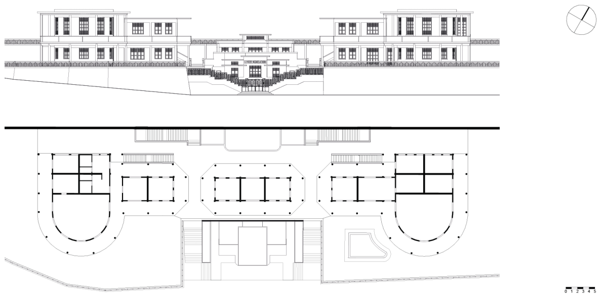
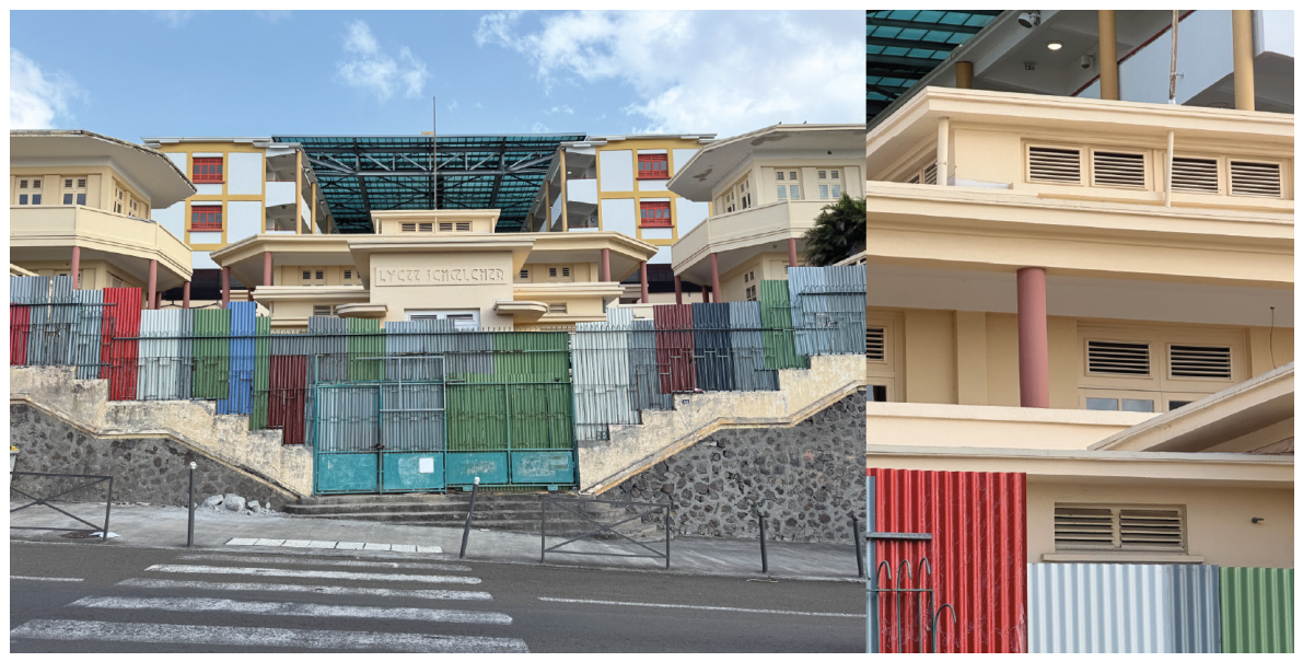
Within this typological category, educational architecture is defined as the volumetric-spatial framework designed to host processes of teaching and learning, as well as intellectual development, in modern Fort-de-France. These buildings are understood as infrastructures of progress that transcend their purely educational function to become instruments of civic formation. This is exemplified by the Lycée Schœlcher, designed by architects Jean and Joseph Soupre in 1937, which operated as a vehicle for social transformation.
In the first decade of the period under study, modern educational architecture is absent from the archival record, marking a baseline of institutional void. Between 1937 and 1946, the cartography of Fort-de-France registers the emergence of the first key landmarks, which respond not only to pedagogical needs but also to a profound demographic and social reconfiguration. These complexes arise as a consequence of mass evacuations from the northern part of the island and, more significantly, from the former capital, Saint-Pierre, following the eruptions of Mount Pelée at the beginning of the twentieth century, which led to the destruction of the city and a major territorial reorganisation of the island.
In this context of expansion, the construction of the Lycée Schœlcher, located on the slopes of Bellevue, is particularly noteworthy. Its elevated siting embodied the appropriation of the hills in line with emerging hygienist principles and strategies of natural ventilation, while simultaneously removing the student population from the insalubrious conditions of the ville basse [23]. Concurrently, the construction of the École de Trenelle responded to the northward expansion of the city, reinforcing the educational network within newly established districts that sought to rationalize and structure the capital’s previously spontaneous urban growth.
Figure 1.
Cartography of educational architecture landmarks in Fort-de-France (1927–1986), highlighting the location of the Lycée Schœlcher. Author’s own elaboration based on the ARMOMA platform, developed by the author and Rafael-José Salcedo-Acosta.
Figure 1.
Cartography of educational architecture landmarks in Fort-de-France (1927–1986), highlighting the location of the Lycée Schœlcher. Author’s own elaboration based on the ARMOMA platform, developed by the author and Rafael-José Salcedo-Acosta.
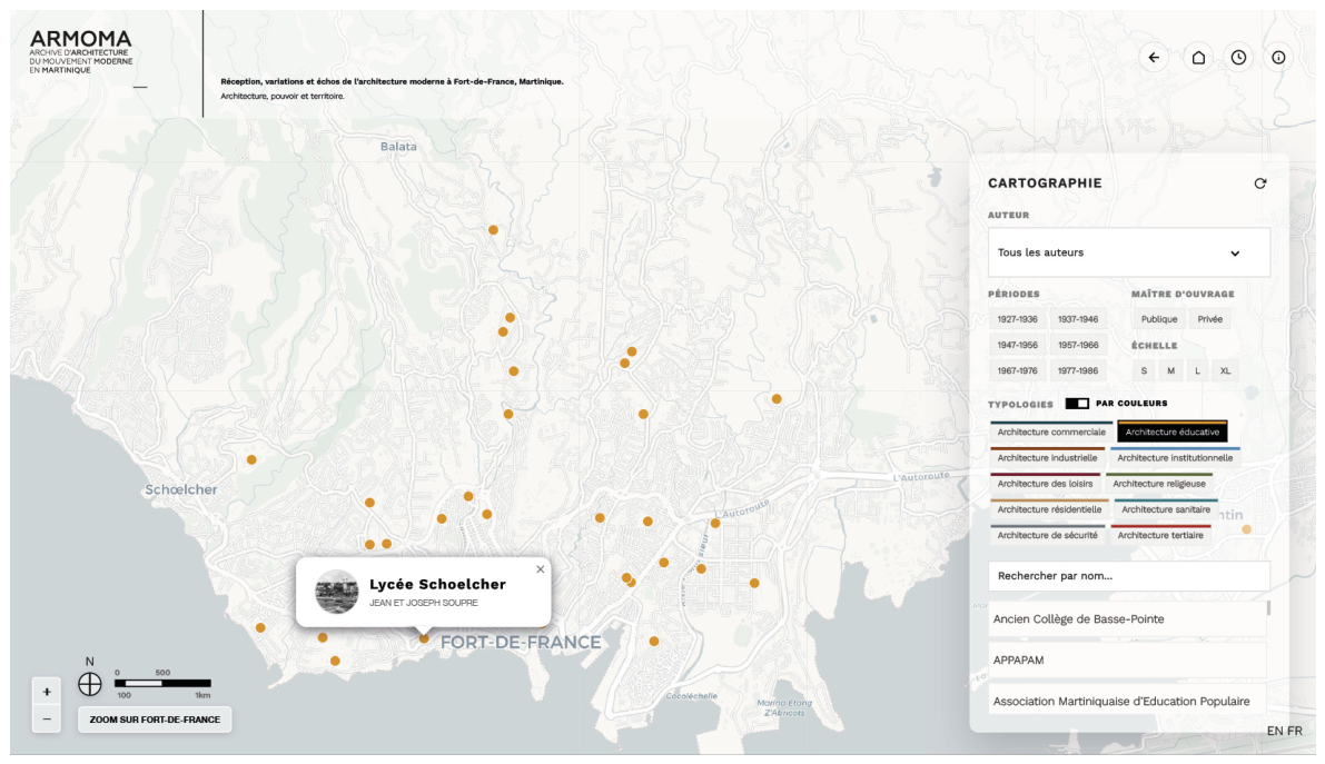
Figure 2.
Main floor plan and south elevation of the administrative building of the Lycée Schœlcher in Fort-de-France. Author’s own elaboration.
Figure 2.
Main floor plan and south elevation of the administrative building of the Lycée Schœlcher in Fort-de-France. Author’s own elaboration.
The transition of Martinique to the status of a French Overseas Department in 1946 was accompanied by a renewed political impetus, embodied in the figure of Aimé Césaire, poet, politician, and mayor of Fort-de-France, who, on 20 December 1945, before the First National Constituent Assembly (Première Assemblée nationale constituante), outlined a roadmap for the island’s modernization when he declared: “We need roads, ports, airports, sanitation; we need hospitals to protect our people from degeneration; we need schools to satisfy the thirst for education of our children” [24].
In this new institutional context, during the period between 1947 and 1956, the expansion of schooling in Fort-de-France became increasingly polarized between public and private provision. On the one hand, municipal public administration, imbued with a conception of education as an essential public service, promoted new growth nodes towards the north and west, seeking to provide services to the expanding urban sectors where the middle and working classes were settling. Concurrently, the eastern part of the city, which included more affluent neighbourhoods such as Bellevue and Cluny–Didier, experienced a rise in private development closely linked to Catholic religious orders. These educational ensembles, erected in a modern aesthetic adapted to a low-density residential environment, consolidated the functional segregation of the urban territory.
Throughout the period 1957–1966, a turning point can be identified, characterized by a veritable surge in educational architecture production, resulting in a significant intensification of institutional density in the intermediate zone between the historic centre and the northern and eastern periphery of Fort-de-France. This phenomenon was accelerated by the 1959 Berthoin Reform [25], which raised the compulsory school-leaving age to 16 and produced a bottleneck effect in existing primary school infrastructure, thereby necessitating a rapid expansion of facilities to accommodate the student population transitioning into secondary education, as exemplified by the construction of the Lycée Bellevue and the Lycée Joseph Gaillard in 1961. In parallel, the consolidation of the departmentalization process enabled the systematic application of French educational legislation and the integration of development programmes under the Monnet Plan. These financial and legal frameworks proved decisive in the planning of schools in newly expanding neighbourhoods, with the aim of materialising the principle of universal access to education.
The period between 1967 and 1976 constitutes a decade of major expansion in educational architecture in Fort-de-France, marked by a densification of the urban fabric that is reflected in the emergence of more than eighteen new landmarks within the city. This construction boom was the direct result of an exceptional political and legal context, notably the implementation of the Sixth [26] (1971-1975) and Seventh [27] (1976-1980) Plans, under which Martinique was granted a status of national priority under the rattrapage policy, a legal mechanism designed to address, through substantial funding from the central state, the historical deficit in infrastructure accumulated by the Overseas Department in relation to metropolitan France.
Architecturally, this translated into the proliferation of the so-called écoles industrialisées, functionally driven, expediently constructed modular buildings that enabled compliance with the constitutional mandate of educational equality within exceptionally short timeframes. The aesthetic of reinforced concrete and modular functional blocks became the dominant architectural language of the new residential districts of the capital, providing neighbourhoods such as Dillon and Sainte-Thérèse with a network of facilities that operated not only as educational institutions, but also as new pillars of urban cohesion in a city expanding rapidly towards its periphery. In this sense, educational architecture in this decade ceased to be an isolated intervention and instead became a large-scale state production system, contributing to the consolidation of Fort-de-France’s urban fabric.
Between 1977 and 1986, the humanist urban project articulated by Aimé Césaire reached its phase of full consolidation. The enactment of the 1983 Loi de Décentralisation [28] granted administrative autonomy to municipalities, including Fort-de-France. However, once the school network had achieved near-complete territorial coverage of the urban fabric—from the coastal zones to the slopes of Balata—the demand for neighbourhood-based primary provision gradually diminished. From the end of this period onwards, the trajectory of educational architecture in Fort-de-France shifted towards a change in scale and typology, privileging departmental-level and representative cultural facilities, such as the Bibliothèque Départementale.
An analysis of the distribution of educational architecture in Fort-de-France in terms of ownership patterns reveals a markedly significant asymmetry. Private education appears only in a marginal, almost anecdotal capacity in quantitative terms, with just three recorded instances across the entire period under study.
Here, by contrast, public provision unfolds through a large-scale expansion that systematically fills all urbanised areas of the capital. This saturation of the urban fabric reflects the architectural expression of a state policy that positioned education as the structuring principle of equal opportunity within the context of departmentalisation. Wherever the city expanded—whether through the spontaneous growth of the mornes (“hills”) or through planned cités (“housing estates”) such as Dillon—the public school arrived as one of the earliest infrastructural provisions.
This network not only fulfilled a pedagogical function, but also operated as a mechanism of social cohesion and territorial integration. Whereas the three instances of private educational architecture remain as isolated enclaves, the pervasive presence of public schools within the urban fabric demonstrates that the production of knowledge was conceived as a universal public service. Ultimately, the cartographic analysis confirms that, in Fort-de-France, school architecture constituted a primary instrument for materialising the right to the city, ensuring that equal opportunity acquired a tangible spatial basis across all neighbourhoods of the municipality.
Figure 3.
Photographs of the administrative building of the Lycée Schœlcher taken in May 2026. Author’s own elaboration.
Figure 3.
Photographs of the administrative building of the Lycée Schœlcher taken in May 2026. Author’s own elaboration.
When categorising infrastructure by dimensional scale, the first significant finding is the absence of any records at the S scale. This absence reflects the administrative structure of the educational system during the period. Unlike primary and secondary schools, crèches (early childhood education facilities) were not incorporated into the state-led school construction programme. Their provision was largely outsourced or embedded within community-based and private arrangements, which did not result in the production of independent architectural works.
Within this framework, the primary phase of architectural deployment operates at the M scale, which constitutes the fundamental unit of the system. This scale corresponds to the écoles (pre-school and primary education facilities), which proliferated throughout the 1960s and 1970s in the context of the expansion of universal access to education. These buildings emerged from state and municipal planning processes and were conceived as functional complexes integrating classrooms, playgrounds, and administrative services within a single architectural and organisational structure.
At the L scale are situated, primarily, the collèges (lower secondary schools), along with those educational complexes constructed during the 1967–76 rattrapage period. These facilities correspond to a sectoral planning logic: they were not conceived to serve a single neighbourhood, but rather a wider catchment area encompassing multiple urban districts. Their architectural configuration is more complex, characterised by specialised volumetric arrangements and a significantly more pronounced territorial footprint, operating as mediating structures between local primary provision and higher levels of educational specialisation.
The XL scale corresponds to monumental departmental infrastructures, including the Lycée Schœlcher, the Lycée Bellevue, the Lycée Joseph Gaillard, and the Schœlcher campus of the Université des Antilles. Positioned along the hillside slopes and characterised by their extensive spatial development, these complexes operate as key geographical markers within the urban landscape. Beyond their strictly educational function, they constitute the most accomplished architectural manifestation of modern institutional authority in the region.
3.2. Healthcare Architecture
Healthcare architecture is defined here as the volumetric-spatial framework that supports the functions of care, healing, and the maintenance of public health and social well-being. Within the scope of this study, these architectural works are conceived as technical infrastructures that materialize modern ideals of hygiene, therapeutic efficiency, and social welfare. Their typological identity lies in their capacity to accommodate medical and social protection functions according to principles of functional order and technical rationality.
Figure 4.
Cartography of Healthcare architecture landmarks in Fort-de-France (1927–1986), highlighting the location of the Complexe Médico-Social de la Caisse Générale de Sécurité Sociale in Fort-de-France. Author’s own elaboration based on the ARMOMA platform, developed by the author and Rafael-José Salcedo-Acosta.
Figure 4.
Cartography of Healthcare architecture landmarks in Fort-de-France (1927–1986), highlighting the location of the Complexe Médico-Social de la Caisse Générale de Sécurité Sociale in Fort-de-France. Author’s own elaboration based on the ARMOMA platform, developed by the author and Rafael-José Salcedo-Acosta.
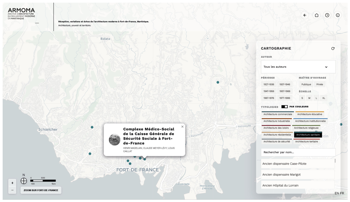
These architectural works, exemplified by the Centre Administratif et Médico-Social de la Caisse Générale de Sécurité Sociale (1956) by architects Henri Madelain, Claude Meyer-Lévy, and the local architect Louis Caillat, function as instruments in the modernization of the social protection system, projecting an image of institutional solidity and of medicine as both an administrative and social enterprise. Their façades, often articulated through solar-control devices and regulated ventilation systems, operate as mediating envelopes of health, expressing the modern imperatives of hygiene, environmental control, and therapeutic efficiency.
Between 1927 and 1936, healthcare architecture underwent a qualitative transformation with the construction of the Hôpital Clarac on the slopes of Morne Desaix. Conceived as a medical district, the project was developed with a far greater volumetric ambition than the former Hôpital Colonial Civil in the Ermitage district, anticipating urban expansion towards the northeast. Its design departed from the smaller-scale logic of earlier healthcare facilities in order to accommodate large medical services, becoming a visual and functional landmark, structuring the territory beyond the original historic core. Set on elevated terrain, the complex overlooked the city, remaining closely tied to colonial architectural aesthetics while simultaneously marking the emergence and institutional consolidation of public healthcare in Martinique.
In the years of wartime uncertainty and the Vichy regime (1937–1946), no significant architectural investments were made in the construction of healthcare facilities. Following its transformation into a French Overseas Department, Martinique adopted the French Social Security system regulated by the 1945 ordinances. The period 1947–1956 reveals a greater spatial dispersion of institutional sites, corresponding to the implementation of treasury and administrative services within existing hospital centres, aimed at establishing a Bismarckian model of social insurance provision. As a key milestone in this new administrative framework, the aforementioned Centre Administratif et Médico-Social de la Caisse Générale de la Sécurité Sociale (Administrative and Medical-Social Centre of the General Social Security Fund) emerged, integrating local services such as Protection Maternelle et Infantile alongside administrative offices responsible for the collection and reimbursement of healthcare services.
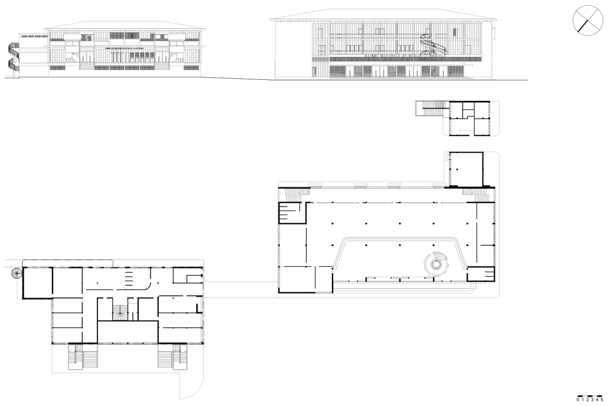
Figure 5.
Ground floor plan and northwest elevation of the Centre Administratif et Médico-Social de la Caisse Générale de Sécurité Sociale in Fort-de-France. Author’s own elaboration.
Figure 5.
Ground floor plan and northwest elevation of the Centre Administratif et Médico-Social de la Caisse Générale de Sécurité Sociale in Fort-de-France. Author’s own elaboration.
Simultaneously, this period marks the rise and modernization of pharmacies in the city centre. These structures, although smaller in scale, are distinctive in that they accommodate laboratories and specialized consultation spaces, functioning as a nexus between commercial modernity and a creole pharmaceutical tradition linked to the concept of the jardin créole [29] (“creole garden”). Architecture thus adapts to the dense urban fabric of Fort-de-France, integrating botanical knowledge rooted in African and Indian traditions into a modern urban language that coexists with local commercial activity.
The period 1957–1966 marks the definitive take-off of modern healthcare architecture, with milestones such as the Maternité de Redoute by architect Louis Caillat. This building represents a radical break with the past of the Hôpital Colonial Civil in the Ermitage district, embracing reinforced concrete, strongly articulated horizontal lines, and, above all, verticality. Located in areas such as Redoute, these constructions operate as beacons of progress, displacing the colonial model of charitable care and replacing it with an architecture of clinical efficiency and formal assertiveness, dominating the new road infrastructures. At the same time, neighbourhood pharmacies—concentrated mainly in the centre of Fort-de-France—continue to provide essential local services, while the Complexe Clinique de Sainte-Marie also emerges. The latter, stemming from Social Security legislation following departmentalization, exemplifies a model in which the private provision of healthcare facilities is fully integrated into the public healthcare system.
In the decade 1967–1976, healthcare architecture added the Hôpital Emma Ventura, which incorporated a residential unit for the elderly and people with disabilities, located along the connecting axis to the municipality of Schœlcher. Urban growth on the outskirts of Fort-de-France was already unstoppable, and healthcare infrastructure accompanied the creation of new neighborhoods. The buildings became increasingly complex in their functional programs, seeking more technologically advanced climatic solutions while simultaneously maintaining a strong aesthetic presence within the urban landscape.
The trajectory culminates (1977–1986) with the construction of the Hôpital Pierre Zobda-Quitman, Centre Hospitalier Universitaire de Martinique (CHUM). This facility represents the ultimate example of a large-scale healthcare facility, situated on the Morne de La Meynard, designed to optimize hygiene and public health through natural ventilation and lighting. Although located away from the historic centre, its connection via major arterial roads allows the CHUM to function as an autonomous infrastructure. Its scale establishes it as an urban landmark, structuring the entire eastern sector of the city and linking it to key energy resources, including the Société Anonyme de la Raffinerie des Antilles (SARA) and the port of La Jambette Bay. With this building, Fort-de-France completes its transition from colonial medicine on the slopes of l’Ermitage to a technicized, globally connected urban healthcare under the framework of departmentalization in the twentieth century.
The distribution of publicly funded healthcare architecture in Fort-de-France follows a logic of territorial sovereignty and strategic expansion, acting as one of the main drivers of the city’s growth toward its peripheries. Examination of the cartography reveals that the public sector has historically abandoned the dense city centre to occupy the mornes and hillsides, seeking both hygienic conditions through natural ventilation and the space necessary to accommodate complex programs. These facilities—from the Hôpital Clarac to the monumental CHUM in La Meynard—are not merely healthcare centres but true urban landmarks that necessitate the development of new transport and energy infrastructures. They embody the State’s intent to structure the department through autonomous and highly technicized architectures which, displaced from the historic core, define the new urban framework of the modern city.
By contrast, the private promotion of clinics and pharmacies forms a more atomized constellation of healthcare facilities. This architecture seeks to integrate into the existing urban fabric, providing local services based on immediacy and market demand. While public facilities expand outward, private initiatives remain anchored in the centre of Fort-de-France and along adjacent residential axes. This coexistence, supported by the French Social Security model, generates a hybrid system in which the public sector undertakes the challenge of large-scale territorial development, while the private sector ensures that healthcare remains an active component of daily life at the heart of the city.
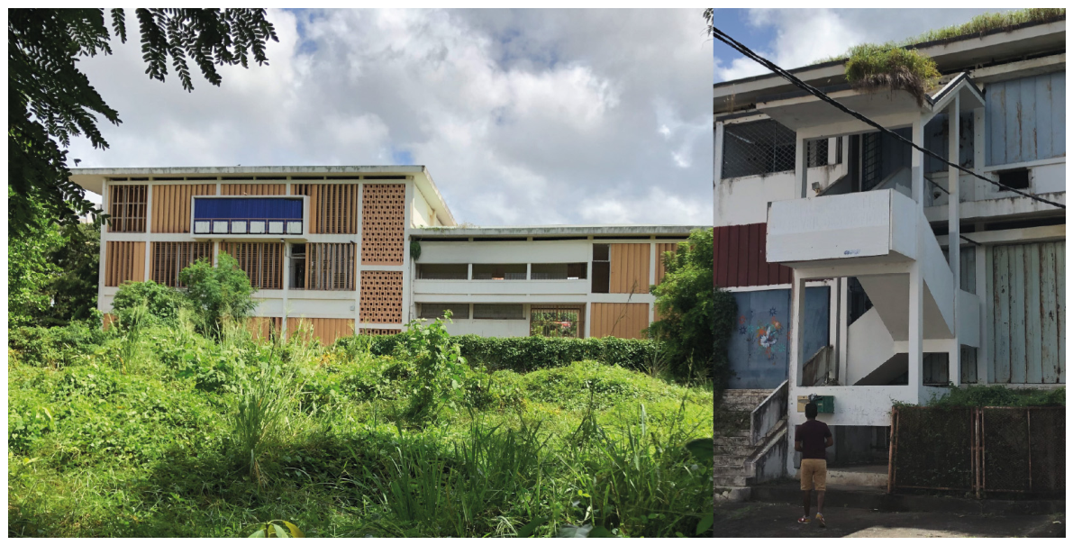
Figure 6.
Photographs of the building taken in June 2021 and May 2026. Author’s own elaboration.
Interestingly, no healthcare landmarks appear at the S scale, reflecting the tendency of even the smallest units to function as complex nodes. As previously noted, a pharmacy in Fort-de-France is not merely a commercial outlet, but a multifunctional building that integrates laboratories, specialist consultation rooms, and professional offices, always achieving a volumetric presence beyond its immediate scale.
At the M scale, we find the core of urban healthcare provision. This category includes pharmacy buildings in the historic centre and, more importantly, the structures that complement the former Hôpital Colonial Civil. These facilities represent the transition towards the new Social Security Act, adapting the functioning of earlier hospital complexes to the administrative and treasury requirements of the Bismarckian model, while maintaining a scale that continues to engage directly with the street.
The L scale represents the defining layer of the city’s healthcare system. This category brings together large-scale buildings that, without reaching full infrastructural autonomy, form an interconnected ecosystem of healthcare nodes. Strategically located along hillside edges and major transport axes, these facilities—such as the Maternité de Redoute and Hôpital Emma Ventura—operate in complementarity, creating a modernist healthcare front that structures the visual landscape of Fort-de-France.
The analysis culminates with the two major XL-scale facilities, which function as sovereign infrastructures. On one hand, the mid-century Hôpital Clarac, which introduced the scale of the cité sanitaire, and on the other, the CHUM, Hôpital Pierre Zobda-Quitman, in the 1980s. These complexes are true cities within the city, with their own operational, energy, and circulation regimes, representing the ultimate expression of the globalized technological container.
3.3. Institutional Architecture
Institutional architecture is defined as the volumetric-spatial framework that provides the physical setting for the functions of the State and the symbolic representation of the French Republic in the Caribbean. This study approaches these works as infrastructural artefacts that operate as manifestations of state power, organizing and modernizing the territory through a combined logic of authority and public service.
Figure 7.
Cartography of Institutional architecture landmarks in Fort-de-France (1927–1986), highlighting the location of the Porte du Tricentenaire in Fort-de-France. Author’s own elaboration based on the ARMOMA platform, developed by the author and Rafael-José Salcedo-Acosta.
Figure 7.
Cartography of Institutional architecture landmarks in Fort-de-France (1927–1986), highlighting the location of the Porte du Tricentenaire in Fort-de-France. Author’s own elaboration based on the ARMOMA platform, developed by the author and Rafael-José Salcedo-Acosta.
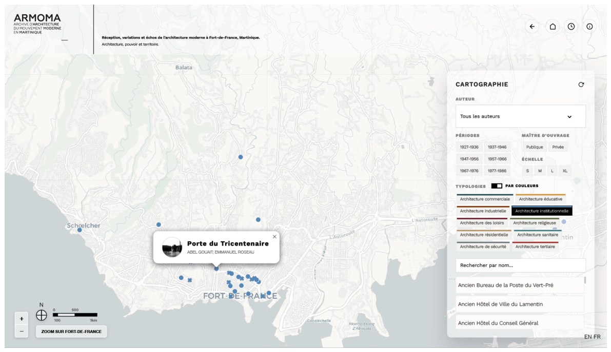
Figure 8.
Cartography of Institutional architecture landmarks in Fort-de-France (1927–1986), highlighting the location of the Maison des Syndicats in Fort-de-France. Author’s own elaboration based on the ARMOMA platform, developed by the author and Rafael-José Salcedo-Acosta.
Figure 8.
Cartography of Institutional architecture landmarks in Fort-de-France (1927–1986), highlighting the location of the Maison des Syndicats in Fort-de-France. Author’s own elaboration based on the ARMOMA platform, developed by the author and Rafael-José Salcedo-Acosta.
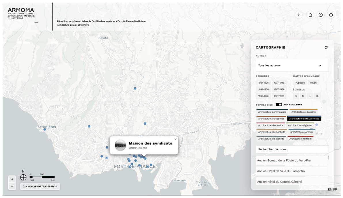
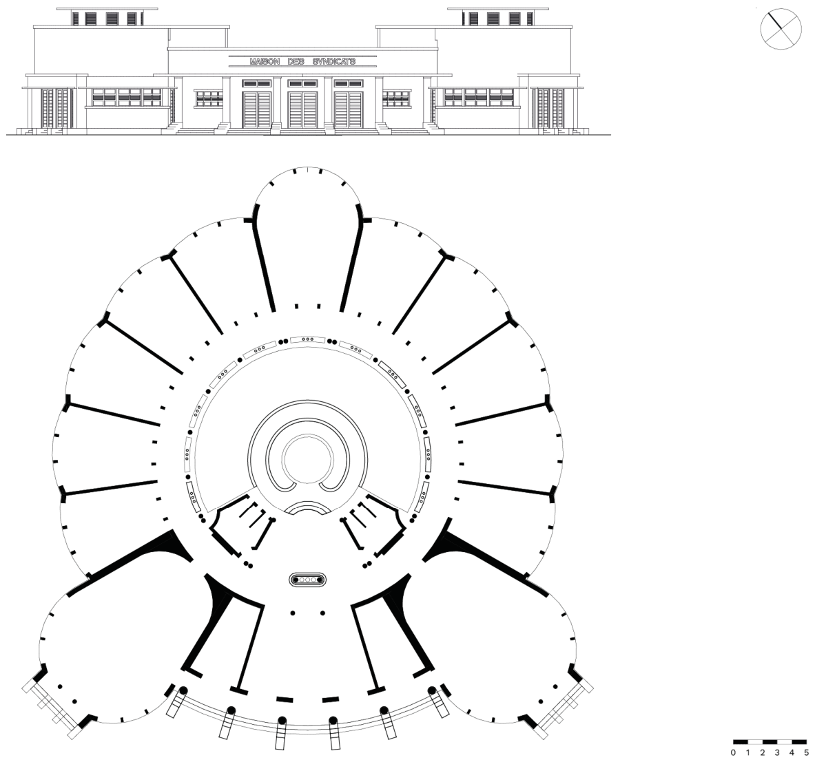
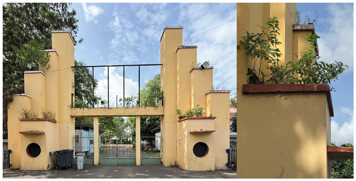
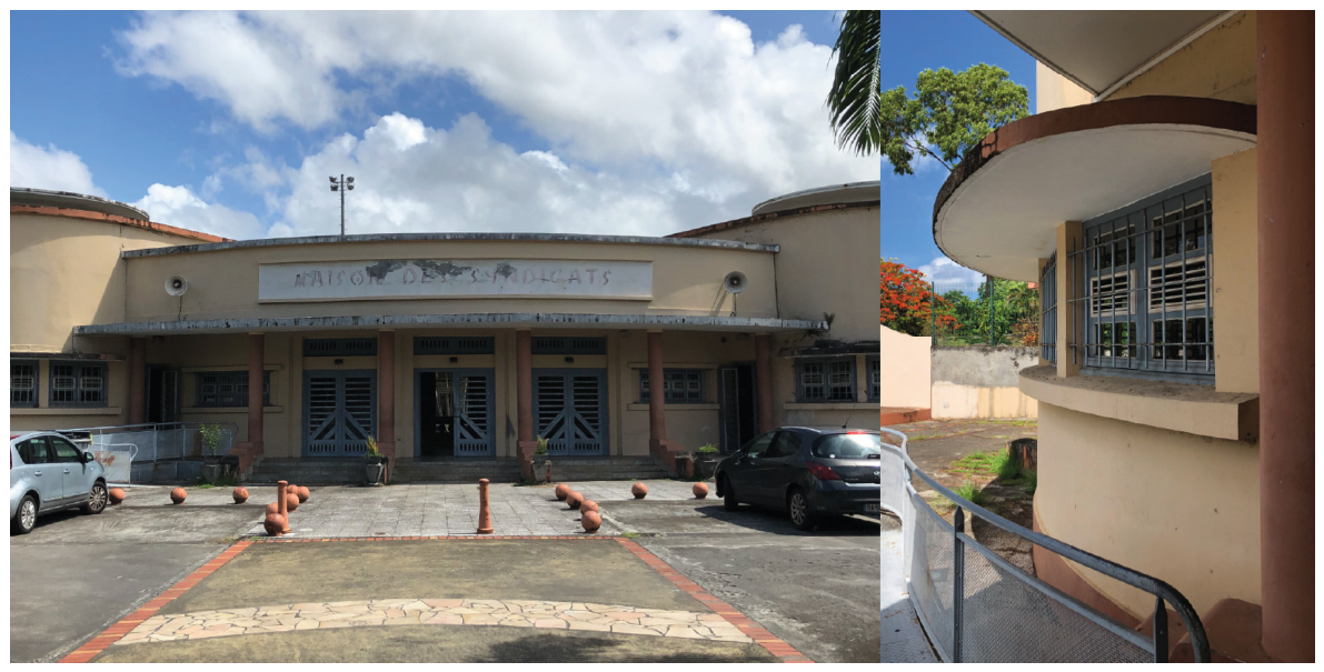
These architectural works operate as vehicles for the communication of power, whereby the building itself projects an image of permanence inseparable from its scale. The modern façade ceases to function merely as a boundary and instead becomes an urban landmark that shapes and defines the city’s growth, as exemplified by the Porte du Tricentenaire (1935) by architects Abel Gouait and Emmanuel Roseau. In many cases, such as the Maison des Syndicats (1948) by architect Marcel Salasc, architecture embodies an aspiration to represent the pillars of the Republic, constructing a landscape of citizenship and inscribing the spatial logic of state power into the urban architectural narrative.
Figure 9.
Floor plan and south elevation of the Porte du Tricentenaire in Fort-de-France. Author’s own elaboration.
Figure 9.
Floor plan and south elevation of the Porte du Tricentenaire in Fort-de-France. Author’s own elaboration.
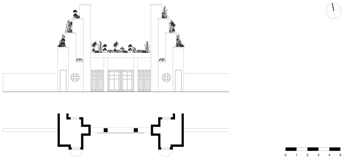
Figure 10.
Floor plan and south elevation of the Maison des Syndicats in Fort-de-France. Author’s own elaboration.
Figure 10.
Floor plan and south elevation of the Maison des Syndicats in Fort-de-France. Author’s own elaboration.
During the period 1927–1936, modern institutional architecture remained concentrated in the ville basse, following the pattern observed across other architectural typologies. Nevertheless, peripheral nodes began to emerge, particularly through the structures designed for the Exposition du Tricentenaire des Colonies Françaises of 1935, located on the grounds of the former Military Hospital. Among these, the Porte du Tricentenaire, the Pavillon de Guyane, and the Fontaine Lumineuse du Tricentenaire in the Terres Sainville district stand out. In parallel, service infrastructures were consolidated through projects such as the Service des Travaux Publics building on Boulevard Général de Gaulle, the headquarters of the Compagnie Générale Transatlantique in Baie des Tourelles, and the Observatoire de Météorologie within the military precinct of Fort Desaix.
Between 1937 and 1946, institutional architecture underwent a phase of consolidation without significant territorial expansion, marked by the constraints imposed by the Second World War and the Vichy regime (1942–1944). Before this phase of stagnation, the Maison du Tourisme was erected in 1940 on the ville basse waterfront, recalling the vision Victor Sévère had outlined in 1931 for the modern city of Fort-de-France. Subsequently, in 1946, the Hôtel du Trésor et du Conseil Général on Boulevard Général de Gaulle, designed by Louis Caillat, emerged as a new institutional landmark and the seat of economic and legislative power. Both buildings were demolished by the end of the twentieth century.
Following departmentalization, institutional architecture adopted a cautious stance during its first decade of implementation (1947–1956). Architectural activity focused on consolidating the administrative axis of Boulevard Général de Gaulle through buildings that reflected the new legal and economic status of the territory. Notable examples from this period include the Maison des Syndicats and the headquarters of the Institut d’Émission des Départements d’Outre-mer (IEDOM), a key state institution responsible for ensuring monetary continuity and stability in the newly established overseas departments. The latter was demolished at the end of the twentieth century.
Institutional landmarks between 1957 and 1966 were closely linked to the development of basic infrastructures and ministerial offices, such as the Direction de la Mer and the Direction de la Poste, as well as the expansion of the Préfecture and the construction of the Banque Nationale de Paris building. Although falling outside the strict scope of this study, it remains within its geographical and functional remit; the construction of the Mairie of the municipality of Schœlcher is particularly notable. This project embodies the State’s policy of territorial expansion through architecture representing the Republic, with the town hall serving as a symbol of state presence in peripheral communes.
During the period 1967–1976, institutional architecture diversified toward social and cultural domains through facilities such as the Archives Territoriales de Martinique at Morne Tartenson, which became a new institutional axis in the heights of Fort-de-France, and the new customs building at the port of the Compagnie Générale Transatlantique. At the same time, municipal institutions closely linked to the State emerged, stemming from universal education legislation, such as the Caisse des Écoles. The opening of the La Poste office in the new Balata district represented a key milestone, as it ultimately shifted institutional presence toward the peripheral residential areas of Fort-de-France.
In the decade spanning 1977 to 1986, the institutional corridor along Boulevard Général de Gaulle was consolidated through the new administrative building of the Mairie de Fort-de-France and the late-1970s extension of the Direction de l’Agriculture, reflecting a stylistic shift toward Brutalism characteristic of late tropical modernism, as well as the constructions of the Finances Publiques and the Maison des Combattants, affiliated with the Ministry of Defence, toward the end of the period. This institutional landscape was further complemented by the Rectorat de Martinique complex, serving as the Ministry of Education’s local authority at Morne Tartenson, and the Centre des Impôts in Cluny, which exemplifies a refined transition toward neo-modern architecture adapted to the tropical context.
Institutional architecture in Fort-de-France during the colonial period should be understood as the materialisation of a political will emanating from the Ministère des Colonies, which deployed urban space, under the implementation of the Service des Travaux Publics, to consolidate French sovereignty in the Caribbean. However, following the Second World War, the Plan Monnet marks a turning point by prioritising the modernisation of basic infrastructure, as a result of legislative frameworks aimed at assimilating and modernising the new overseas department.
In addition, at the end of 1946, the Fonds d’Investissement pour le Développement Économique et Social (FIDES) [30], was established to support the development of the colonies and overseas departments. Subsequently, in 1958, the Fonds d’Investissement des Départements d’Outre-mer (FIDOM) [31], was created, enabling the establishment of the Atelier d’Urbanisme des Antilles et de la Guyane (AUAG), headquartered in Fort-de-France and reporting to Ministère de la Construction in Paris, to coordinate the development of urban and architectural projects in the Antilles. This Atelier remained operational until 1977, when it was transformed into a departmental association, chaired and managed locally.
It is at the smallest scale (S) that the institutional landmark manifests as an urban element. This category encompasses elements of an ornamental and symbolic nature, such as the Fontaine lumineuse du Tricentenaire in Terres Sainvilles or the Porte du Tricentenaire, whose significance lies in their historical resonance. This scale also includes the early local technical services at neighbourhood scale and small administrative offices which, like the initial rural post offices, sought to establish a direct and human point of contact between the Republic and its citizens in emerging settlements.
Figure 11.
Photographs of the Porte du Tricentenaire taken in May 2026. Author’s own elaboration.
The M scale represents the standardization of public services prior to departmentalization and the construction of large institutional buildings. These are buildings that, while maintaining a human scale, introduce specific functional programmes and a clearly defined modern aesthetic. Also included in this category are the headquarters of technical services, such as the Service des Travaux Publics or the Observatoire de Météorologie in Fort-Desaix, whose architecture must balance administrative functions with specific technical or scientific requirements.
At the L scale, architecture acquires a primary representational and urban dimension. Notable buildings include the Maison des Syndicats, the IEDOM, and the extensions of the Préfecture, which occupy blocks or highly visible plots, designed to house offices and centralize the management of state sectors. These landmarks create powerful institutional nodes by concentrating in specific locations such as the Boulevard Général de Gaulle, which functions as the central administrative axis, or the Morne Tartenson, where architecture takes advantage of the topography to emphasize its public presence. Thus, the large-scale institutional architecture of the island is not a singular object, but a network of modernist and brutalist infrastructures that organize the urban fabric from its most visible and trafficked points.
Figure 12.
Photographs of the Maison des Syndicats taken in June 2021. Author’s own elaboration.
Unlike other examples of international modern architecture, where large, compact administrative cities were designed at the XL scale, in Fort-de-France this typology does not include singular megastructures, but rather a conglomerate of modern works from different periods.
4. Entanglements of the Architecture of Power and the Welfare State with the Residential City
Institutional landmarks constitute a rigid structure: they cluster in the city centre and trace a clear axis towards the east and north. In contrast, educational architecture displays a widespread capillary distribution: its buildings extend deep into the rugged northern areas and are evenly scattered across all urban fabrics to the east and west, creating a far more extensive and decentralised network than that of institutional architecture.
There is clear evidence of coordinated planning driven by the welfare state in the aftermath of Departmentalisation. While educational facilities display a homogeneous distribution—virtually one school for every new neighbourhood—healthcare infrastructure operates through concentrated nodes. Both share a concern for hygienic conditions, being located in well-ventilated, sunlit, and elevated sites on the mornes, while also contributing to the consolidation of the residential fabric. Their main difference lies in the scale of their intervention: healthcare architecture serves a broader catchment area, whereas educational facilities are deployed in a range of sizes. Nevertheless, both function as interconnected networks that legitimise and consolidate urban expansion beyond the city centre, extending into hillsides and along new development corridors in order to serve the already established residential fabric.
Healthcare and institutional architecture exhibit a very close territorial alignment, sharing the same development corridors towards the urban periphery. Large healthcare complexes do not operate as isolated entities; rather, they are positioned according to the same deployment logic as administrative headquarters, particularly in the transitional zone between the historic centre and the northern quadrant. This coexistence suggests coordinated state planning, whereby public service infrastructure and healthcare provision mutually reinforce one another in structuring urban development.
This alignment is further confirmed by the way both programmes are distributed along the same arterial roads. While institutional architecture defines the nodes of governance, healthcare architecture is established in larger-scale complexes while maintaining strategic proximity, allowing the main administrative axis to function simultaneously as a connector for major healthcare services. Together, these two typologies delineate a network of public facilities that advances in tandem from the founding core of the ville basse towards the city’s new growth poles.
Figure 13.
Cartography of institutional, educational, healthcare, and residential architecture landmarks in Fort-de-France (1927–1986), highlighting the location of the Maison Didier. Author’s own elaboration based on the ARMOMA platform, developed by the author and Rafael-José Salcedo-Acosta.
Figure 13.
Cartography of institutional, educational, healthcare, and residential architecture landmarks in Fort-de-France (1927–1986), highlighting the location of the Maison Didier. Author’s own elaboration based on the ARMOMA platform, developed by the author and Rafael-José Salcedo-Acosta.
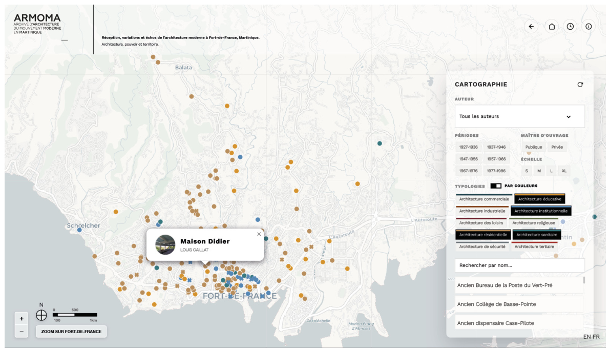
Figure 14.
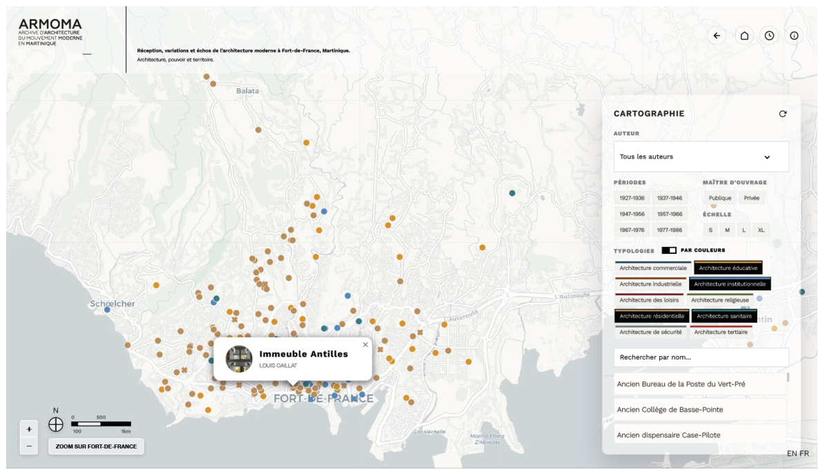
Cartography of institutional, educational, healthcare, and residential architecture landmarks in Fort-de-France (1927–1986), highlighting the location of the Immeuble Antilles. Author’s own elaboration based on the ARMOMA platform, developed by the author and Rafael-José Salcedo-Acosta.
Figure 14.
Cartography of institutional, educational, healthcare, and residential architecture landmarks in Fort-de-France (1927–1986), highlighting the location of the Immeuble Antilles. Author’s own elaboration based on the ARMOMA platform, developed by the author and Rafael-José Salcedo-Acosta.
The relationship with residential architecture is perhaps the one that best illustrates the effort of rattrapage in public facilities required after Departmentalisation. Schools and social housing can be seen as two complementary facets of the same state project, in which the state acknowledges that, in order to dignify citizenship, shelter alone is not sufficient, and access to knowledge is imperative. New urban plans such as the Cités of Floréal, De Briant, and Godissard include all necessary educational facilities, as does the Cité of Dillon. Schools are also built in areas where informal housing or private speculative developments had been established years earlier, in order to serve the entire population and make equality of opportunity effective in practice.
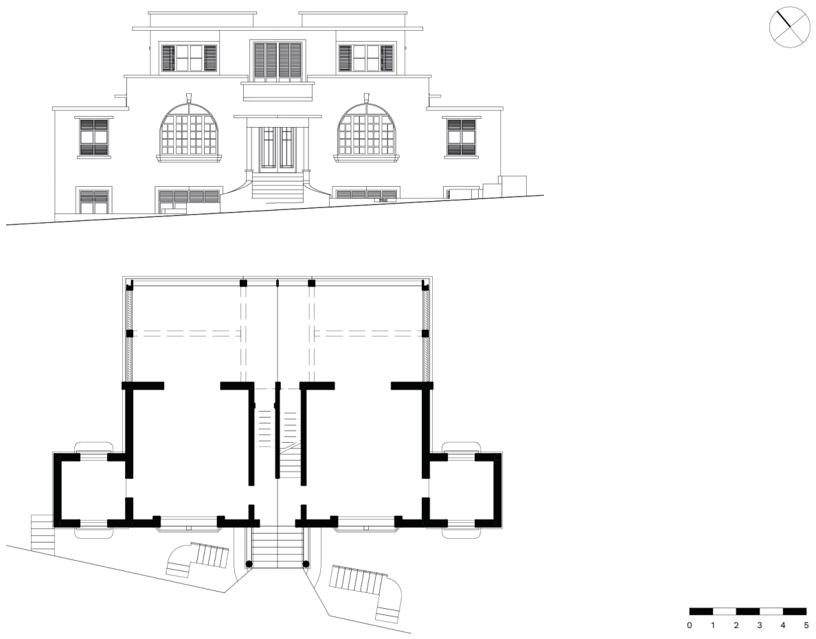
While residential architecture unfolds in a massive and almost organic manner across the rugged topography of the mornes, such as the Maison Didier (1935) by architect Louis Caillat, occupying hillsides and remote valleys, public healthcare architecture maintains a rear-guard position, rigidly tied to major transport infrastructures. A linear system of healthcare provision thus emerges, providing services to adjacent neighbourhoods. Although these complexes are accessible by vehicle, they remain physically distant and disconnected from the internal life of the new neighbourhoods.
In this context of imbalance, newly created neighbourhoods experience a gap in healthcare provision that the public sector is unable to cover. It is precisely within this gap that private development finds its strategic opportunity, acting as the only effective bridge between housing and healthcare. Private clinics and pharmacies manage to break the rigidity of the transport corridors, penetrating the residential fabric and blending into the scale of the neighbourhood, thereby ensuring a capillary distribution of services. Thus, healthcare in Fort-de-France is divided between a large-scale public network that dominates the logistical horizon and a private network that ensures the continuity of local, neighbourhood-level care at the heart of urban expansion.
Figure 15.
Ground floor plan and southwest elevation of the Maison Didier in Fort-de-France. Author’s own elaboration.
Figure 15.
Ground floor plan and southwest elevation of the Maison Didier in Fort-de-France. Author’s own elaboration.
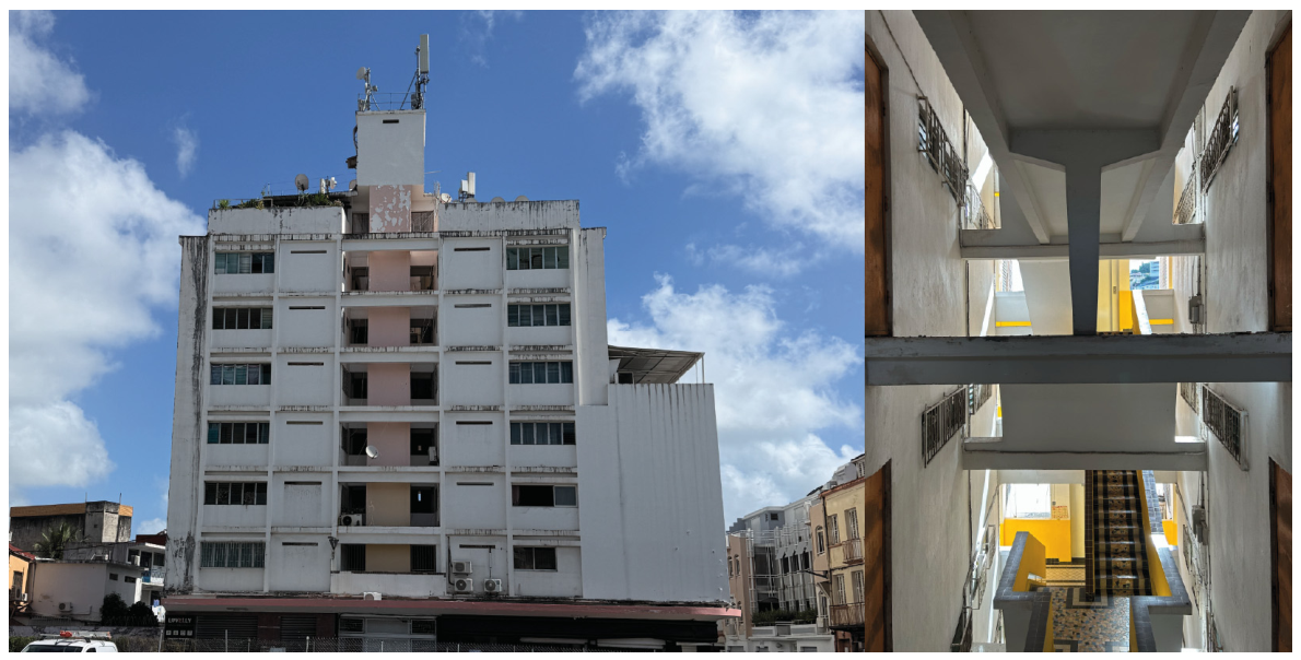
The relationship between residential and institutional architecture is expressed through strategic nodes embedded within these large housing areas or located at their edges, providing technical and administrative services to the population. This configuration suggests a state-driven intent to follow demographic growth and engage directly with the residential fabric, validating and regulating new settlements through the presence of public infrastructure. This relationship was further reinforced in the urban core through early collective social housing milestones, such as the Immeuble Antilles (1958) by architect Louis Caillat in the ville basse.
Nevertheless, this institutional integration is markedly less dense and less capillary than in the case of educational infrastructure. While schooling is atomised in order to be present at the heart of each neighbourhood and neighbourhood unit, institutional architecture operates according to a logic of selective centralities and service nodes. In this way, the institution is positioned as the administrative anchor that provides structure to large housing estates, while maintaining a logistical concentration that prioritises communication corridors over the total and uniform presence characteristic of educational infrastructure.
Figure 16.
First floor plan and west elevation of the Immeuble Antilles in Fort-de-France. Author’s own elaboration.
Figure 16.
First floor plan and west elevation of the Immeuble Antilles in Fort-de-France. Author’s own elaboration.
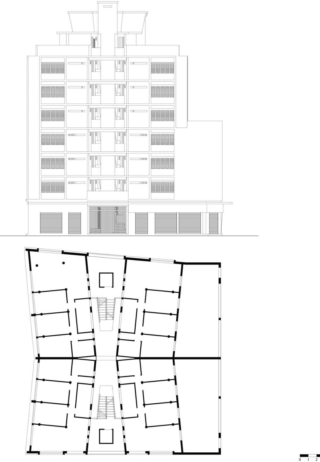
Figure 17.
Photographs of the Maison Didier taken in May 2026. Author’s own elaboration.
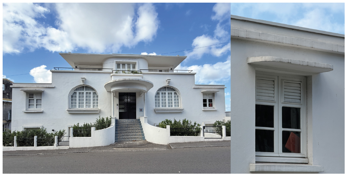
Figure 18.
Photographs of the Immeuble Antilles taken in May 2026. Author’s own elaboration.
5. Discussion and Conclusions
This study has examined the presence in the city of Fort-de-France of modern architectures through which not only the city itself is constructed, but also the image of state power and the welfare state within Western modernity/context. This process of consolidation unfolds over time following the Great Depression of 1929 and is reinforced after the Second World War, a chronological span covered in this study: 1927–1986. The findings allow us to challenge the idea that modern architecture was a monolithic block imported from the metropole, but also that it constituted a complete process of créolisation (“creolisation”), suggesting instead a series of variations and echoes that persisted over time.
In Martinique, the process unfolded gradually and was driven by the private sphere. Modernity did not emerge as an immediate avant-garde reconstruction in the aftermath of the volcanic disaster at the beginning of the century, but rather as an evolution of the ville basse, propelled by private housing developments that were only later, decades afterwards, taken up by the state. This raises questions about the temporal boundaries of the Modern Movement on the island: while DOCOMOMO takes 1965 as its closing date, in Fort-de-France we find echoes and variations that extend its relevance by as much as twenty years, thus supporting the thesis of “alternative modernity” proposed by Pérez Escolano.
After the Second World War, and under the framework of the Monnet Plan and the FIDES schemes, architecture in France became an instrument of state representation. Concrete was not merely a material, but a central component of a new economy of modernisation. The discussion here should focus on how the deployment of educational, healthcare, and housing infrastructures sought to materialise the welfare state, in an attempt to reconfigure the perceived legacy of colonial abandonment.
Moreover, the widespread use of reinforced concrete in Martinique generated economic dependency. It enabled formal freedom and the standardisation of large-scale construction, while providing greater resilience to climatic conditions; however, it also marked the decline of regional construction autonomy based on the stone from northern quarries and local tropical timber. It became necessary to develop infrastructure tied to the importation of materials, linking the growth of the modern city to transatlantic supply and finance chains.
This period is marked by a temporal and political disjuncture: while the Constitution of the Fourth Republic and the rhythms of metropolitan France were already advancing from 1946 onwards, the effective implementation of public facilities in Fort-de-France took more than a decade to consolidate. In the 1950s, Aimé Césaire’s remark—“We received the first Compagnies Républicaines de Sécurité (CRS) before we saw the first implementation of Social Security!”—encapsulates the fundamental contradiction of the early Departmentalisation period, in which welfare infrastructures arrived belatedly, while the coercive apparatuses of the state, as well as taxation systems, were established almost immediately. A more recent example, Martinique’s full incorporation into the EU Social Charter (1996) only taking effect on 1 May 2026, illustrates a persistent historical pattern: modernity reaches the French Caribbean with a chronological lag that follows the logic of assimilation.
Nevertheless, in certain cases, what appears as a delay in fact allowed for a maturation of the original models, as can be observed in architecture. When, in Martinique, the peak of collective residential architecture took off in the 1960s, internal critiques of its rigidity were already emerging at the heart of the Modern Movement, such as those of Team X at the 1953 CIAM Congress. In this sense, Fort-de-France imported a form of modern architecture that had already undergone processes of testing and critical reassessment: it adapted a canon that had already been adapted.
Modern architecture in Fort-de-France cannot be understood solely as an aesthetic or technical exercise, but also as an ideological battleground. In Aimé Césaire’s discourse of 20 December 1945, this is made explicit: “If they want the Antilles and Martinique to be freed from the bitter situation into which they have been led by the old politics inherited from the colonial pact, there is only one means: to equip them.” While the French state deployed its institutional architecture to reaffirm control, the population and its intellectual leaders demanded modernity as a vehicle for human dignity. In this context, the Parti Communiste de Martinique (PCM) and figures within Césaire’s circle acted as “architects of consciousness.” Designing a hospital or a school was not merely the fulfilment of a functional programme: it was an act of resistance aimed at materialising departmentalisation.
A paradigmatic example is the Maison des Syndicats. This building stands as a material response to the arrival of the CRS. In opposition to the architecture of repression, the PCM and the trade unions, under the protection of Césaire as deputy in the Assemblée Nationale, promoted spaces for workers’ self-organisation. Here, modernity, with its free plans and its transparency achieved through claustras and timber joinery, symbolises a society driven by a desire for democratic modernity.
In contrast, urban projects designed from France, such as the Cités of Balata (Floréal, De Briant, and Godissard), prioritised quantity over quality and the discourse of modernity over adaptability. These projects, although reinterpreted by critical figures such as Antoine de Roux, Georges Candilis, and Sandy Woods, did not prevent segregation nor avoid the reproduction of planning failures in the French Antilles, despite having been discussed at the 1953 CIAM Congress. The tabula rasa envisaged by the Dubuisson Plan for the ville basse of Fort-de-France is a reminder of the disconnect between large-scale European urbanism and the social reality of the territory, where the urgent need for decent housing was essential for those who migrated from rural areas to the city.
A final contrast concerns the divergence between the Imprimerie Officielle (1936) and the Complexe médico-social de la Caisse Générale de la Sécurité Sociale (1958), which illustrates this traumatic transition. The former was created to serve the efficiency of colonial decrees, tightening the administrative grip of control. Its demolition in 2025, under the label of a “symbol of oppression”, disregarded its technical value and replaced physical memory with an ornamental “non-place”. By contrast, the latter embodied a “conquered right”. This building stands as testimony to a social pact in which citizenship gains access to the modernity of public healthcare through equality in taxation and fiscal treatment.
Its survival supports our hypothesis that modern structures are resilient. The intervention by architect Amélie Deguingand of the DACAR studio in 2026, transforming the building into housing for students and young professionals, demonstrates that Caribbean rationalism is flexible; its concrete skeleton and permeable façades allow an essential adaptability for contemporary urban regeneration. Looking at the past of modern architecture in Fort-de-France is not an act of nostalgia, but an ecological responsibility towards the future. The Imprimerie Officielle was also a work that could have been resilient to colonial history and an example of modern architecture adapted to contemporary use.
The conclusions that emerge from the discussion of the research findings may be summarised as follows. First, architectural modernity in Fort-de-France can be understood as an instrument of republican consciousness. The deployment of institutional facilities was not merely a constructive undertaking, but a mechanism through which the French state projected an image of equality and articulated the modernity of the welfare state. However, this process was fundamentally asynchronous, revealing a temporal gap of up to thirty years between metropolitan policy frameworks and their materialisation in the overseas departments.
Second, the prominent role of savoir-faire (“know-how”) and constructive resilience. Modernity in Fort-de-France results from the synergy between imported technical knowledge and situated craftsmanship. For instance, the use of timber joinery with porous shutters, in contrast to the aluminium systems predominant in Europe, as well as the design of thermally permeable elements through ceramic or reinforced concrete claustras, demonstrate that this architecture is intrinsically sustainable and adapted to the tropical context, achieving a level of bioclimatic performance that surpasses many contemporary constructions.
Third, segregation as a by-product of progress. The discourse of development functioned as a screen for the implementation of cité-based urban models that segregated the population according to levels of resources. In this respect, urban modernity in Fort-de-France remains indebted to the social integration of its peripheries, a condition it shares with L’Hexagone.
Fourth, adaptability in the face of the tabula rasa. Buildings such as the Complexe médico-social de la Caisse Générale de la Sécurité Sociale demonstrate that modern architecture is inherently flexible. Its capacity for adaptive reuse and its natural thermal comfort position it as a model of frugality and reuse strategies, in contrast to the political tendency towards demolition, which erases historical and architectural memory.
Finally, the need to move towards a “creolised” approach to heritage. The demolition of the Imprimerie Officielle highlights the urgency of rethinking how modern heritage is perceived. It should not be understood solely as a vestige of the oppressive state, but rather as a hybrid architecture embedded within the very identity of Martinique. It is necessary to prioritise the coherence of typological series over isolated monumentality.
Author Contributions
Conceptualization, David Fontcuberta-Rubio; methodology, David Fontcuberta-Rubio; software, David Fontcuberta-Rubio and Rafael-Jose Salcedo-Acosta; validation, Maria-Elia Gutiérrez-Mozo; formal analysis, David Fontcuberta-Rubio; investigation, David Fontcuberta-Rubio; resources, David Fontcuberta-Rubio; data curation, David Fontcuberta-Rubio; writing—original draft preparation, David Fontcuberta-Rubio and María-Elia Gutiérrez-Mozo; writing—review and editing, David Fontcuberta-Rubio and María-Elia Gutiérrez-Mozo; visualization, David Fontcuberta-Rubio; supervision, María-Elia Gutiérrez-Mozo; All authors have read and agreed to the published version of the manuscript.
Funding
This research received no external funding.
Institutional Review Board Statement
Not applicable.
Informed Consent Statement
Not applicable.
Data Availability Statement
ARMOMA Archives d’Architecture Moderne en Martinique.
Acknowledgments
During the preparation of this manuscript, the authors used Gemini (June 2026 version) for the purposes of cross-checking archival data, locating legislative references, and verifying formatting guidelines for project nomenclature. The authors have reviewed and edited the output and take full responsibility for the content of this publication. The authors would like to express their sincere gratitude to the following institutions, organizations, and entities for their invaluable support, collaboration, and access to archives during the development of this research the Ministère de la Culture (France), the Agencia Española de Cooperación Internacional para el Desarrollo (AECID) del Ministerio de Asuntos Exteriores y de Cooperación (España), the Institut Français, the Cité de l’Architecture et du Patrimoine - Institut Français de l’Architecture, the Inventaire Général du Patrimoine Culturel, the Collectivité Territoriale de Martinique (CTM), the Direction des Affaires Culturelles (DAC) de la Préfecture de la Martinique, the Direction des Affaires Culturelles (DAC) de la Préfecture de la Guadeloupe, the Direction de la Culture, de la Jeunesse et du Sport de la Préfecture de la Guyane, the Direction de l’Environnement, de l’Aménagement et du Logement (DEAL) de la Martinique, the Unité Départementale de l’Architecture et du Patrimoine (UDAP) de la Martinique, the Architectes des Bâtiments de France (ABF) de la Martinique, the Architectes des Bâtiments de France (ABF) de la Préfecture de La Réunion, the Archives Nationales d’Outre-Mer (ANOM), the Gallica - Bibliothèque Nationale de France (BnF), the Archives Départementales de la Martinique, the Ville de Fort-de-France, the Ville du Lamentin, the Université des Antilles, the Universidad de Alicante, the Universidad Politécnica de Madrid, the École Nationale Supérieure d’Architecture de La Réunion (ENSAM), the Federación Panamericana de Asociaciones de Arquitectos (FPAA), the Conseil National de l’Ordre des Architectes de France, the Ordre des Architectes de la Martinique, the Ordre des Architectes de la Guadeloupe, the Ordre des Architectes de la Guyane, the Conseil d’Architecture, d’Urbanisme et de l’Environnement (CAUE) de la Martinique, the Maison de l’Architecture de la Martinique, the Association pour la Défense de l’Architecture Moderne en Martinique, the Fondation du Patrimoine, the DoCoMoMo International, the DoCoMoMo France, the Archivos de Arquitectura Antillana, the Fondation Clément, the Union REMPART, the Association Française du Génie Parasismique (AFPS) de Martinique, the Groupe Action Logement, the Groupe Monplaisir, the Groupe Iterato, Naço Tropical, and abitē.
Conflicts of Interest
The authors declare no conflicts of interest.
References
- Haraway, D. Situated knowledges: The science question in feminism and the privilege of partial perspective. Fem. Stud. 1988, 14(3), 575–599. [Google Scholar] [CrossRef]
- Sebastiani, L.; Álvarez Veinguer, A. Investigar con cuidado. Cambios de actitud frente al extractivismo epistémico y ontológico como formas para sostener las vidas [Researching with care: Changes in attitude toward epistemic and ontological extractivism as ways of sustaining life]. Cuad. De Relac. Laborales 2024, 42(2), 319–336. [Google Scholar]
- In this regard, see the following ten foundational references: Arango, S. (2012). Arquitectura Moderna Latinoamericana: el juego de las interpretaciones. Anales del Instituto de Arte Americano e Investigaciones Estéticas “Mario J. Buschiazzo”, 4242(1), 39-54. Bergdoll, B., Comas, C. E., & Liernur, J. F. (2015). Latin America in Construction: Architecture 1955–1980. MoMA. Bullrich, F. (1969). Nuevos caminos de la arquitectura latinoamericana. Gustavo Gili. Esteban Maluenda, A. (Ed.) (2016). La arquitectura moderna en Latinoamérica. Antología de autores, obras y textos. Reverté. Hitchcock, H.-R. (1955). Latin American Architecture since 1945. MoMA. Montaner, J. M. (2010). Arquitectura y crítica en Latinoamérica. Nobuko. Quintana Guerrero, I. (Ed.) (2025). Divergencias: Arquitectura en América Latina y discursos finiseculares. Universidad de los Andes. Sambricio, C. (Ed.). (2012). Ciudad y vivienda en América Latina 1930-1960. Lampreave. Segre, R. (1999). América Latina en su arquitectura. Siglo XXI Editores. Waisman, M. (1990). Elinterior de la historia: Historiografía arquitectónica para uso de latinoamericanos. Escala. [CrossRef]
- DOCOMOMO. Le mouvement moderne dans les îles Caraïbes [The Modern Movement in the Caribbean Islands]. In DOCOMOMO Journal; DOCOMOMO International, 2005; Volume (33). [Google Scholar]
- Pérez Escolano, V. A European Glance in the Mirror of Caribbean Modern Architecture. DOCOMOMO J. 2005, (33). [Google Scholar]
- Sévère, V. Fort-de-France (1639-1931): L’urbanisme aux colonies [Fort-de-France (1639–1931): Urbanism in the colonies]. L’Architecture 1931, 8, 284–288. [Google Scholar]
- Roux, A. de. Le centre de Fort-de-France, ses possibilités d’adaptation [The center of Fort-de-France: Its possibilities for adaptation]; Centre d’Études Régionales Antilles-Guyane [Center for Regional Studies Antilles-Guyane], 1967. [Google Scholar]
- Image of the “Projet pour la reconstruction du centre de Fort-de-France (1945)” [Project for the Reconstruction of the Center of Fort-de-France (1945)] by Louis Caillat; reproduced in Doucet; J.; Bouin, Y. Louis Caillat: Itinéraire d’un homme libre.; HC Éditions, 2014; p. 16. [Google Scholar]
- The Dubuisson Plan for Fort-de-France proposed a tabula rasa of the ville basse akin to Le Corbusier’s Plan Voisin for Paris, deploying massive linear high-rise blocks designed to completely eliminate the unsanitary conditions inherent to the city’s colonial grid.
- https://annuaire-entreprises.data.gouv.fr/entreprise/assoc-defense-promo-archit-moder-martini-adam-martinique-413871005.
- Villard, Ph.; Doucet, J. Le logement social à la Martinique: 100 ans d’histoire – chroniques 1902–2004 ; [Social housing in Martinique: 100 years of history – chronicles 1902–2004]; DDE Martinique, 2004. [Google Scholar]
- Servant, J. Une architecture oubliée; [An forgotten architecture] [Documentary film]; SCI Productions / France Télévisions, 2007. [Google Scholar]
- Doucet, J. Architectures modernistes en Martinique 1927–1968; [Modernist architectures in Martinique 1927–1968]; Somogy Éditions d’Art, 2007. [Google Scholar]
- Torres, G.; Domínguez, M. Urba 37: Inventaire du patrimoine architectural, urbain et paysager de Fort-de-France [Urba 37: Inventory of the architectural, urban, and landscape heritage of Fort-de-France]. In Ville de Fort-de-France; 2008. [Google Scholar]
- Loi n° 46-451 du 19 mars 1946 tendant à l’érection en départements français de la Guadeloupe, de la Martinique, de la Réunion et de la Guyane française [Law No. 46-451 of March 19, 1946, regarding the elevation of Guadeloupe, Martinique, Réunion, and French Guiana to French departments]. J. Off. De La République Française 1946, (0067), 2294.
- Huygues-Belrose, V. Atlas des paysages de la Martinique [Landscape atlas of Martinique]; PNRM, 2013. [Google Scholar]
- The earliest modern work in Fort-de-France was the Église de Saint-Antoine, designed by architects Charles-Albert Wulffleff and Aloys Verrey in 1927, while the period concludes with the Direction Générale des Finances Publiques by Jean Willerval and Jean-Camille Petit in 1986.
- This massive state funding reflects the policy of rattrapage (economic and social catching-up), an institutional effort by the French state to modernize infrastructure and align the living standards of the overseas departments with those of mainland France.
- A geopolitical and cartographic concept referring to continental, European France, so named due to the approximate geometric outline of its borders. Within the framework of postcolonial studies and critical geography, the term l’Hexagone is deployed to decenter the traditional metropolitan concept of the “center” (the Metropole) in relation to its “insular peripheries” (the Overseas Departments), thereby exposing the structural asymmetries in spatial governance and political relations between the two territories.
- Loi n° 82-213 du 2 mars 1982 relative aux droits et libertés des communes, des départements et des régions [Law No. 82-213 of March 2, 1982, regarding the rights and freedoms of communes, departments, and regions]. (1982, March 3). Journal officiel de la République française, (0052), 730. Loi n° 83-8 du 7 janvier 1983 relative à la répartition des compétences entre les communes, des départements, les régions et l’État [Law No. 83-8 of January 7, 1983, regarding the allocation of competencies among communes, departments, regions, and the State]. (1983, January 9). Journal officiel de la République française, (0007), 215. Loi n° 83-663 du 22 juillet 1983 complétant la loi n° 83-8 du 7 janvier 1983 relative à la répartition de compétences entre les communes, los départements, les régions et l’Etat (1) [Law No. 83-663 of July 22, 1983, supplementing Law No. 83-8 of January 7, 1983, regarding the allocation of competencies among communes, departments, regions, and the State]. (1983, July 23). Journal officiel de la République française, (0169), 2286.
- Loi n° 86-824 du 11 juillet 1986 de finances rectificative pour 1986 [Amending Finance Law No. 86-824 of July 11, 1986, for the Year 1986]. J. Off. De La République Française 1986, (0161), 8688.
- Institut National de l’Information Géographique et Forestière (IGN). (n.d.). Remonter le temps. [Remonter letemps historical aerial photography and cartography platform]. Retrieved June 18, 2026, from. Available online: https://remonterletemps.ign.fr.
- The term ville basse (“lower city”) designates the foundational and historical core of Fort-de-France. Characterized by an alluvial plain, this sector is structured around an orthogonal colonial grid, whose geometric and hygienic regularity contrasts diachronically with the subsequent spontaneous and vernacular occupation of the surrounding slopes or mornes.
- Césaire, A. Discours prononcé à l’Assemblée nationale constituante: Débat sur le projet de loi relatif au régime des départements d’outre-mer. Speech delivered at the National Constituent Assembly: Debate on the draft law regarding the status of overseas departments, 1945, December 20; Assemblée nationale. [Google Scholar]
- Décret n° 59-57 du 6 janvier 1959 portant réforme de l’enseignement public [Decree No. 59-57 of January 6, 1959, regarding the reform of public education]. J. Off. De La République Française 1959, (0005), 422.
- Loi n° 71-567 du 15 juillet 1971 portant approbation du VIe Plan de développement économique et social (1971-1975) [Law No. 71-567 of July 15, 1971, approving the 6th Economic and Social Development Plan (1971–1975)]. J. Off. De La République Française 1971, (0163), 7003.
- Loi n° 76-670 du 21 juillet 1976 portant approbation du VIIe Plan de développement économique et social (1976-1980) [Law No. 76-670 of July 21, 1976, approving the 7th Economic and Social Development Plan (1976–1980)]. J. Off. De La République Française 1976, (0170), 4395.
- Loi n° 83-8 du 7 janvier 1983 relative à la répartition des compétences entre les communes, les départements, les régions et l’État [Law No. 83-8 of January 7, 1983, regarding the allocation of competencies among communes, departments, regions, and the State]. J. Off. De La République Française 1983, (0007), 215.
- Marc, J.-V. Le jardin créole à Fort-de-France: stratégie de résistance face à la pauvreté? [The Creole garden in Fort-de-France: A strategy of resistance against poverty?]. VertigO-La Rev. éLectronique En. Sci. De L’environnement 2011, 11(1). [Google Scholar] [CrossRef]
- Loi n° 46-860 du 30 avril 1946 tendant à l’établissement, au financement et à l’exécution de plans d’équipement et de desarrollo des territoires relevant du ministère de la France d’outre-mer [Law No. 46-860 of April 30, 1946, aiming at the establishment, financing, and execution of equipment and development plans for territories under the Ministry of Overseas France]. J. Off. De La République Française 1946, (0102), 3635.
- Ordonnance n° 58-870 du 24 septembre 1958 relative a la gestion des fonds d’investissement des départements d’outre-mer [Ordinance No. 58-870 of September 24, 1958, regarding the management of investment funds for the overseas departments]. In Journal officiel de la République française; 24 September 1958.
Disclaimer/Publisher’s Note: The statements, opinions and data contained in all publications are solely those of the individual author(s) and contributor(s) and not of MDPI and/or the editor(s). MDPI and/or the editor(s) disclaim responsibility for any injury to people or property resulting from any ideas, methods, instructions or products referred to in the content. |
© 2026 by the authors. Licensee MDPI, Basel, Switzerland. This article is an open access article distributed under the terms and conditions of the Creative Commons Attribution (CC BY) license (http://creativecommons.org/licenses/by/4.0/).
Copyright: This open access article is published under a Creative Commons CC BY 4.0 license, which permit the free download, distribution, and reuse, provided that the author and preprint are cited in any reuse.


