

Submitted:
11 June 2026
Posted:
12 June 2026
You are already at the latest version
Abstract
Transitional ecosystems such as estuaries are highly dynamic, subject to multiple human pressures that can alter their structure and functioning. This study applied a cumulative effects method together with a cause-consequence-response framework to the Mondego estuary (Portugal) to evaluate cumulative impact risks (IR) associated with human activities across ecological components. Transport, extraction and cultivation of living resources, water management and urban and industrial activities were identified as the main sectors generating pressures, including physical loss, introduction of non-indigenous species, nutrient enrichment, introduction of synthetic compounds, smothering and litter. Transport, particularly shipping and associated infrastructure, exhibited the highest potential IR, largely through habitat modification and potential introduction of non-indigenous species. Extraction and cultivation sectors mainly affected littoral biogenic habitats and the water column through nutrient and organic matter enrichment. Cluster analyses revealed two main pressure domains: (i) water-mediated influencing pelagic and mobile fauna and (ii) habitat-specific affecting benthic and shoreline components. Comparisons with elsewhere showed that cumulative and historical disturbances, such as channelisation and dredging, continue to shape the ecosystem conditions over decades. Unifying both frameworks provided complementary insights linking human drivers, activities, pressures and ecological responses, while identifying priorities for estuarine restoration and integrated management. These quantified ecological responses to cumulative pressures and management through restoration potential and more effective governance and management.
Keywords:
DAPSI(W)R(M)
; SCAIRM
; coastal governance
; transitional systems
; ecosystem components
1. Introduction
Human settlement on waterways, estuaries and coasts provide essential pathways for access and transport, and support economic development (Grey et al., 2002). Increasing coastal human populations reflects the unique accessibility of resources, services and goods and benefits generated by the interface between fluvial and marine systems (Davis and Kidd, 2012; Thrush et al., 2014). These transitional systems include estuaries and wetlands, such as saltmarshes and seagrass meadows (Baird and Elliott, 2024) which are characterized by halophytic vegetation, adapted to wide salinity gradients, providing critical habitat for a high functional biodiversity. These productive coastal ecosystems regulate nutrient cycling, sequester carbon and provide natural protection against erosion and flooding (Alongi et al., 2020; Burke et al., 2022). These ecological functions underpin the provision of ecosystem services (ES) that support human societies. The Millennium Ecosystem Assessment (MEA, 2005) framed ES as the benefits people obtain from ecosystems, a concept later refined to separate ecological processes and functions from the societal goods and benefits (SG&B) generated after introducing complementary assets and human capital (Turner et al., 2014; Elliott et al., 2017; Elliott, 2023). In this interpretation, ecosystems represent natural capital stocks composed of ecological components (EC) and processes that generate flows of ES. The Common International Classification of Ecosystem Services (CICES v5.2) similarly emphasises the link between ecological contributions and societal benefits, providing a basis for assessing how anthropogenic pressures may affect service and benefits provision.
The increasing demand for goods and benefits from estuarine ecosystems has intensified human activities, enhancing coastal development while reducing ecosystem resistance and resilience (EMB, 2024). Activities such as channel deepening for navigation, dike construction for human safety, industrialisation and land claim for agriculture and urban development have altered estuarine morphology and generated significant cumulative pressures (Li et al., 2018; Kennish, 2023; European Marine Board, 2024). These pressures contribute to habitat degradation and biodiversity loss in estuarine zones (Atkins et al., 2011; Barbier et al., 2011) and are compounded by the combined effects of urbanisation, resource exploitation and reduced ecosystem resilience, often described as the ‘triple whammy’ (Defeo and Elliott, 2021). In addition, climate change, particularly sea-level rise, is expected to intensify these impacts in coastal and estuarine systems in the coming decades (IPCC, AR6, 2023; Kennish et al., 2023). Together, these interacting pressures threaten ecosystem integrity and, ultimately, human well-being in the long term.
The United Nations Sustainable Development Goals 14 (“Life Below Water”) and 15 (“Life on Land”) call for the conservation and sustainable use of marine and terrestrial ecosystems through integrated management approaches that preserve biodiversity, ecosystem services and societal benefits (Schmidt et al., 2017; Gulseven et al., 2020; Elliott and Kennish, 2024). To support ecosystem-based management, structured frameworks have been developed to link ecosystem components, functions and services and to assess how natural or anthropogenic changes affect ecological and societal outcomes (Armoškaitė et al., 2020). Among these is the structured cause-consequence-response conceptual framework, DAPSI(W)R(M) (defined bellow and in Elliott et al.,2017) with an example in Polette et al. (2026), where climate change, coastal development and tourism pressure combined effect are analysed on coastal socio-ecological systems. The Spatial Cumulative Assessment of Impact Risk for Management (SCAIRM) framework applies a spatial, risk-based approach to quantify the cumulative impacts by assessing activity–pressure–ecosystem linkages (Piet et al., 2023). Together, these tools provide a coherent basis for operationalising ecosystem-based management through the assessment, monitoring and mitigation of anthropogenic pressures, even under data-limited conditions.
This study presents a novel method of unifying DAPSI(W)R(M) and SCAIRM approaches to address the challenges associated to estuarine management. While DAPSI(W)R(M) identifies local human needs, activities and associated pressures to satisfy those needs, SCAIRM provides a semi-quantitative indicator of cumulative pressures and their potential risks to ecosystem components (EC). Together, these approaches improve the understanding of cumulative anthropogenic impacts and support the development of sustainable management strategies. The unified framework was applied to the Mondego estuary (Portugal), a highly modified transitional waters system affected by multiple anthropogenic pressures, in order to evaluate its applicability to estuarine ecosystems. Using a literature review and expert judgement, the study aims to: (i) identify human needs, activities and pressures in the system; and (ii) determine which activity sectors and pressures represent the higher potential risk to estuarine ecosystem components. The remaining DAPSI(W)R(M) elements, of societal impacts and management responses, are discussed below but not yet analysed in detail here (Polette et al., 2026 analyses all elements as an example).
2. Material and Methods
2.1. The Mondego Estuary
2.1.1. Study Area
The study area comprised the Mondego estuary, adjacent saltmarshes and the coastal zone of Figueira da Foz, on the Portuguese Atlantic coast (40°08 N, 8°50 W) (Marques and Nogueira, 1991) (Figure 1). The coastal city of Figueira da Foz has a total area of 379.1 km2 with 58,982 habitants and a population density of 156 habitants per km2 (PORDATA, 2021). The estuary is approximately 8.6 km2 in area and its upstream limit is 21 km from its mouth (Teixeira et al., 2008). The lower estuary (approximately 7 km) is divided into the north and south arms by Morraceira Island (Marques et al., 2003). The southern arm (2–4 m during high tide) is shallower than the northern arm (10-12 m near the mouth) and 75% is characterised by large areas of intertidal mudflats (Neto et al., 2008). In this region, the main socio-economic activities include manufacturing, transport (maritime and by land), tourism and agriculture.
Human activities historically met societal needs and although these activities have changed over several centuries, human development has continually altered patterns of resource exploitation. Increasing industrialisation and the intensification of human activities may compromise the resilience of transitional systems such as estuaries (Figure 2). For instance, agriculture and flood protection have altered the Mondego system hydrodynamics. Partial siltation of the upstream areas of the southern arm of the estuary reduced water circulation, which, together with agricultural nutrient inputs, resulted in eutrophication (de Jonge and Elliott 2002). This became a major concern which led to macroalgal blooms and decline of important habitat such as Zostera seagrass beds, affecting socio-economic activities (Gardoki et al., 2025). Following the implementation of management and mitigation measures, the system partially recovered after. Reopening channels, reducing water residence time and improving nutrient-load management (Costa et al., 2013; Gardoki et al., 2025).
2.2. Typologies of Drivers, Activities, Pressures and Ecosystem Components
The DAPSI(W)R(M) concept is a cause-consequence-response framework, which links human Drivers, Activities and related Pressures to their environmental State change and their Impacts (on human Welfare) and well-being. In turn, these need to be addressed using Responses (as management Measures) (Elliott et al., 2017). This study characterizes the interactions between human Drivers, Activities, Pressures and ecosystem components, using the example of the Mondego estuary.
The selection of activities, pressures and ecosystem components relevant to the Mondego estuary was based on a review of the scientific literature and expert knowledge of the study system, using MSFD classifications and EUNIS typologies as the underlying framework. The resulting inventories were refined through expert judgement to reflect the ecological characteristics and socio-economic uses of the study area.
2.2.1. Drivers (D)
The concept of ‘Drivers’ has been inconsistently defined in previous literature, often conflating ideological frameworks with activities or economic sectors. Here, Drivers are defined as fundamental human needs, consistent with the hierarchical model proposed by Maslow (1943) and later elaborated by Elliott et al. (2017). This model organizes human motivation into a five-tier pyramid structure, wherein the fulfilment of lower-tier needs (e.g., physiological requirements) is a prerequisite for the pursuit of higher-order aspirations such as self-actualization and personal achievement. Within the context of the Mondego estuary, the selected Drivers reflect essential human demands shaped by economic development, the blue economy interest and broader societal imperatives, specifically those related to food, energy and water security.
2.2.2. Activities (A)
Activities, the human interactions undertaken to satisfy fundamental needs (i.e., Drivers), create, Pressures as the resulting mechanisms of environmental natural and societal change (Elliott et al., 2017). In this study, human activities are broadly categorised into ten key marine activity sectors, as delineated by the European Marine Strategy Framework Directive (MSFD; 2008/56/EC), encompassing 32 distinct activities that exert heterogeneous environmental pressures. For instance, commercial and artisanal fishing include both pelagic and benthic methods, each associated with different ecological impacts. Thus, to enhance analytical precision, MSFD activities were separated into specific activities tailored to the case study, since different operational methods may generate distinct cause–effect pathways.
2.2.3. Pressures (P)
Pressures are defined here as the mechanism of change on both the natural system (State change) and the human system (Impacts on welfare) (Elliott and O’Higgins, 2020). Pressures can be separated into Exogenic Unmanaged Pressures (ExUP) and Endogenic Managed Pressures (EnMP) (Elliot et al., 2017). ExUPs originate outside the spatial or jurisdictional boundaries of the managed marine or estuarine system. As a result, their causes cannot be managed through local interventions—climate change is a paradigmatic example (Elliott et al., 2016) but their consequences must still be addressed through adaptive management and mitigation measures. In contrast, this study focuses on EnMPs, which arise within the managed area and for which both the causes and ecological consequences are subject to direct management and regulation. Importantly, the ecological consequences of a given Pressure can be either detrimental or beneficial, depending on the context and the ecosystem component affected. For instance, the construction of breakwaters may initially exert negative effects on benthic communities but can subsequently support colonization by macroalgae and epifaunal organisms, potentially enhancing local biodiversity (Glueck et al., 2025). The list of 25 endogenic pressures employed in this study is based on the Smith et al. (2016) revising the original pressure list in the MSFD Annex III of the EU Directive 2017/845 amending Directive 2008/56/EC and White et al. (2013) for marine and estuarine ecosystems (Elliott et al., 2017). This list was further adapted and expanded with additional terminology to address the specific ecological and management contexts in the Mondego estuary.
2.2.4. Ecosystem Components (EC)
In further stages of the DAPSI(W)R(M) framework, the ecosystem components (EC) are effectively captured when pressures act directly on the natural system, leading to State changes in the environment (Elliott et al., 2023). Therefore, indicating the relevant EC is required, as well as determining their integration and relevance within the SCAIRM system. Ecosystem components represent the foundational biotic and abiotic constituents of ecological systems, encompassing species assemblages and habitat structures, and judged against baseline indicators. The structural and functional integrity of these EC are modulated by pressures arising from anthropogenic activities. They are the receptors of environmental change, translating external stressors into ecologically consequential ‘State change’. The dynamic interplay among these components directs ecosystem functionality, resilience and service provision and thus they constitute the primary targets for ecological monitoring, assessment and management interventions within adaptive governance. In this study, the hierarchical classification system applied to coastal and estuarine ecosystems encompasses seven EC, as defined under the MSFD and the Habitats and Species Directive, including habitat types (e.g. seabed and water column) and species groups. To interrogate these further, the assessment deconstructs these into 21 specific components, according to the EUNIS hierarchical habitat typology classification (European Environment Agency, 2022).
2.3. Data Analysis
2.3.1. SCAIRM
As a complementary risk-based cumulative impact assessment method, SCAIRM is used to support ecosystem-based management of marine and coastal environments (Piet et al., 2023). The approach is designed to evaluate the cumulative impact of human activities and their pressures on ecosystem components (EC). It integrates categorical risk assessment (e.g., using expert judgment) with quantitative information, with each activity-pressure-ecosystem component linkage representing the relative likelihood of a given receptor (component) being affected by specific stressor (activity or pressure). The linkage between the different stages was based on the MSFD and supported by expert judgment and literature review (Elliott, et al., 2017; Piet, et al., 2023, 2024; Bisinicu, et al., 2024). For each linkage, the approach estimates the potential State change of an ecosystem component, expressed as impact risk (IR). This provides a quantitative basis for decision-making by identifying which pressures contribute most to risk and which management measures most effectively reduce cumulative impacts. In practice, several parameters were considered to calculate the final impact risk (IR), following the equations proposed by Borgwardt et al. (2019). For instance, Exposure of an EC to an associated pressure depends on two spatial parameters: (i) Dispersal, which describes how far a pressure spreads from its source to the environment (e.g., nutrient input) and (ii) Extent, which represents the spatial overlap of each activity-pressure combination with an ecosystem component (e.g., surface is receiving agricultural runoff) (Eq. 1).
Effect potential is another major component, representing the strength of a pressure on an EC when exposed. Naturally, this depends on Resistance (Eq. 2), the capacity of an EC to absorb or withstand a pressure. Nevertheless, Resistance is influenced by two parameters: (i) Hazard, which reflects the pressure nature (e.g.: seagrass beds are highly sensitive to trawling, resulting in low resistance, but more moderately affected by nutrient enrichment, resulting in higher resistance) and (ii) Magnitude, which reflects the intensity of the pressure (e.g. low intensity trawling may have little impact, whereas high intensity trawling can exceed system resistance, resulting in high effect potential).
Recovery (Eq. 3) is defined as the rate at which a receptor returns to its original undisturbed state, was estimated using receptor-specific expert judgment scores from Knights et al. (2015) (SM1). Thus, Resilience is defined as the time required for full recovery after impact (Piet et al, 2023).
Depletion (Eq. 4) translates the resistance of a habitat or species into a quantitative measure of vulnerability. Low resistance values correspond to high depletion, indicating greater sensitivity to pressures. If the resistance value is lower than , the value . is used instead.
In addition, Effect Potential (Eq. 5) represents the extent to which a receptor is likely to be affected by a given stressor, expressed as a change in biomass or abundance relative to its undisturbed state (Piet et al., 2023; Bisinicu et al., 2024). Effect potential is calculated from the recovery and depletion values defined in (Eq. 3) and (Eq. 4), respectively.
Ultimately, the IR is defined as the representative alteration of the natural equilibrium of a receptor (i.e. biomass or abundance) caused by a stressor (i.e. fisheries) (Eq. 6). Here, the scoring system is based on Piet et al. (2024), following Knights et al. (2015) and Borgwardt et al. (2019) (SM 1).
Assessing the impact risk involves analysing how various human activities can potentially affect the ecosystem (Piet, et al., 2023). The current study activity data used a two-year assessment period. Impact risk values represent a forward-looking assessment of potential relative impact risk under current activity levels, integrating both immediate and delayed ecological responses over a medium- to long-term timescale (approximately 5 to 15 years). Alterations in ecosystem components state may not be immediately observable due to inherent resilience and ecological responses can require extended periods to become detectable, which justifies adopting a medium- to long-term impact horizon.
Although these two approaches differ in structure and emphasis, they are highly complementary operating at distinct yet interconnected levels of decision-making. DAPSI(W)R(M) addresses the questions “What is happening, why is it happening and where can interventions occur?”, whereas SCAIRM, primarily a management and governance framework, focuses on “How should decisions be assessed, prioritised, implemented and adapted under uncertainty?”. While DAPSI(W)R(M) identifies cause–consequence–response relationships, SCAIRM builds on this logic by explicitly recognising activities, pressures and system components and by assigning semi-quantitative values to associated pressures and impacts. This enables systematic comparisons across activities, receptors and scenarios. In this way, DAPSI(W)R(M) functions as the problem-framing stage, while SCAIRM constitutes the assessment stage. This complementarity is particularly relevant because, once pressures affecting the composition of the natural system are identified, SCAIRM allows their relative importance and risk to be distinguished through semi-quantitative assessment (Figure 3). The approaches can be applied independently of data availability, integrating both qualitative and quantitative information into a single harmonised output. As outlined in the previous section, this study applies a practical example to identify Drivers, Activities, Pressures and Ecosystem Components and to assign semi-quantitative impact risk scores to associated pressure chains in an estuarine system.
2.3.2. Multivariate Analysis
Multivariate similarity analyses were carried out to explore patterns in the distribution of impact risk among ecosystem components and to identify groups of components with similar response profiles, following established community data analysis procedures (Anderson et al., 2008). Based on the semi-quantitative SCAIRM assessment, two separate similarity analyses were conducted: a pressure-based analysis and a sector-based analysis. Both analyses were performed in Q-mode, where ecosystem components represented the cases (samples) and IR values associated with individual pressures or sectoral activities constituted the attributes. In the pressure-based analysis, each ecosystem component was characterised by its IR profile across pressures, whereas in the sector-based analysis ecosystem components were characterised by their IR profile across activity sectors, using PRIMER v6 (Anderson et al., 2008). Impact Risk values describing the linkages between receptors (EC) and stressors (pressures and activity sectors) were fourth-root transformed to reduce the influence of dominant values and balance the contribution of weaker interactions. Bray–Curtis similarity matrices were then calculated and used as input for a hierarchical cluster analysis with group-average linkage (CLUSTER) to identify groups of ecosystem components exhibiting similar responses to pressures and sectoral activities. For visual interpretation of clustering results, each EC was associated with the stressor exhibiting the highest IR value, derived from the same IR dataset used to construct the similarity matrices. This attribution represents the dominant contributing stressor (activities and pressures) and supported the interpretation of the clustering results and does not imply exclusive or singular influence. Sankey Diagrams then visualise the linkages of the grand IR total of the Activities, Pressures and EC to evaluate those that might represent a greater risk for environment and society.
3. Results
3.1. Drivers, Activities, Pressures and Ecosystem Components
The features of the Mondego estuary are intrinsically linked to the socio-economic demands and human activities characteristic of estuarine and coastal systems (Pinto et al., 2010). A total of 10 drivers were acknowledged as significant human basic needs that relate to the MSFD activity sectors (Table 1). Maslow’s hierarchy can be applied to the Mondego estuary, where food, water and energy represent human needs for survival, whereas education and leisure correspond to higher-level self-fulfilment. Individual activity sectors may address multiple needs; for example, the extraction of living resources (fish, shellfish, algae) not only provide food but may also represent a self-fulfilment activity when pursued as recreational hunting or fishing. To satisfy human needs, from the most basic to those of self-realization, activities represent the physical actions through which these demands are fulfilled/met.
For the Mondego estuary, nine of the ten activity sectors defined under the MSFD (EU, 2017) were identified. These activity sectors included water management, extraction of living and non-living resources, cultivation of living resources, energy production, transport, education and research, tourism and leisure, and urban and industrial uses. Within these sectors, 24 of the 32 corresponding activities were identified to provide a more detailed and robust framework construction (SM 2). The identified activities were further categorized into activity methods (e.g., dredging, nourishment), human infrastructures (e.g., ports, salt pans) and practices or uses (e.g., yachting, concerts). Based on these activities, a total of 24 pressures were identified in the Mondego estuary following the classification proposed by Elliott et al. (2017) (SM 3). To evaluate the potential effects of these pressures on the ecosystem, eleven ecosystem components (EC) were considered in the analysis, representing key biological species groups and habitats of the Mondego estuary. These are fish, cephalopods, birds, mammals, water column, littoral biogenic habitats, littoral mud, littoral mixed sediments, infralittoral sand, infralittoral mud and coastal habitats. Together, these components represent both pelagic and benthic compartments of the estuarine ecosystem and capture the diversity of habitats and taxa potentially affected by human activities.
3.2. Impact Risk
3.2.1. Activity Sector
Activity sectors contributed unevenly to the total IR in the Mondego estuary (Figure 4). Transport accounted for the largest share of the total IR (18%), followed by extraction of living resources (17%), cultivation of living resources (16%) and water management (16%). In contrast, education and research (5%), extraction of non-living resources (2%) and energy production (1%) represented minor contributions to the overall IR.
3.2.2. Pressure
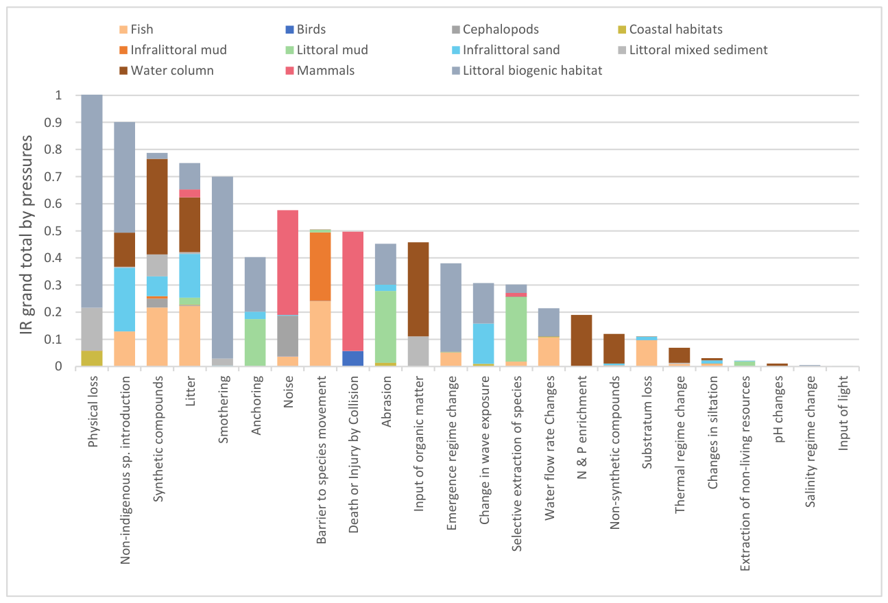
Impact risk also varied across pressures in the Mondego estuary (Figure 5). The largest contribution to the total IR was associated with physical loss (12%), followed by introduction of non-indigenous species (10%) and introduction of synthetic compounds (9%). Litter and smothering each accounted for 8% of the total IR. Several additional pressures, including noise, barriers to species movement and death or injury by collision, contributed around 6% each, whereas input of organic matter, abrasion and anchoring represented smaller contributions.
3.2.3. Similarity Patterns Among Ecosystem Components
Hierarchical cluster analysis applied to the IR matrix of ecosystem components across activity sectors revealed a structured grouping among the eleven EC, forming four main clusters (Figure 6). The first major cluster grouped fish, littoral biogenic habitats, water column, infralittoral sand and mammals (similarity > 65%), indicating shared exposure to pressures mainly related to transport and water management. A secondary stressor was additionally indicated when its IR value was within 16% of the dominant value, reflecting cases of comparable influence. This criterion was met for a limited number of EC. For fish, cultivation of living resources emerged as a co-dominant sector alongside the primary stressor. In littoral biogenic habitats, water management was identified as a secondary stressor, while for littoral mixed sediments extraction of non-living resources also showed a comparable contribution. For all remaining EC, secondary stressors exhibited IR values substantially lower (≤58% of the dominant value) and were therefore not considered indicative of comparable influence. A second cluster included cephalopods and littoral mud (≈ 57% similarity), reflecting common influences from the extraction of living resources. Birds and littoral mixed sediment, the main feeding and roosting habitat of the birds, formed a distinct group (≈ 49% similarity), mostly associated with urban and industrial uses and the cultivation of living resources. Finally, coastal habitats and infralittoral mud showed the lowest similarity (≈ 30%), suggesting a differentiated pattern of pressures possibly linked to tourism and coastal management. Overall, the clustering highlights that EC connected to similar human-use sectors tend to exhibit comparable impact-risk patterns. The overall structure indicates the existence of several hierarchical levels of association among EC, reflecting varying degrees of similarity in their exposure and response patterns across activity sectors.
Hierarchical cluster analysis applied to the impact risk (IR) matrix of ecosystem components across pressures showed generally low similarity among EC (<20%), indicating substantial variability in their impact-risk profiles under different pressures (Figure 7). The first pelagic–infralittoral cluster grouped fish, infralittoral sand and water column (similarity > 55%), reflecting shared exposure to introduction of non-indigenous species, barriers to movement and contamination by synthetic compounds. Here, a secondary pressure was indicated when its IR value was within 17% of the dominant value. For fish, the introduction of synthetic compounds emerged as a co-dominant pressure alongside barriers to species movement. In mammals, noise was identified as a secondary pressure, while for the water column inputs of organic matter also showed a comparable contribution. For all remaining ecosystem components, secondary pressures exhibited IR values substantially lower (≤57% of the dominant value) and were therefore not considered indicative of comparable influence. A second cluster comprised birds, mammals and cephalopods (≈ 35–48% similarity), all of which are highly mobile taxa sensitive to underwater noise and collision risk. The third cluster included littoral mud and littoral biogenic habitat (similarity > 45%), which were influenced by abrasion and physical loss. These clusters further merge with coastal habitats, littoral mixed sediments and infralittoral mud (similarity <40%), which were primarily influenced by barriers to species movement and physical loss.
3.3. Activity–Pressure–EC pathways
A total of 826 activity–pressure–ecosystem component linkages were identified across the nine activity sectors considered in the analysis. The final IR scoring matrix (here) is available in an external repository for review purposes. Among these, extraction of living resources accounted for the highest number of linkages (265), followed by water management (123) and tourism and leisure (120). These linkages reflect the complexity of interactions between human activities and environmental pressures within the estuarine system. A Sankey diagram is used to synthesise Activity–Pressure–Ecosystem Component pathways derived from the DAPSI(W)R(M) framework and their associated impact risk (IR) values (Figure 8). Flow widths are proportional to normalised IR values, indicating dominant and secondary pathways of potential risk propagation. The diagram shows that a limited number of activity–pressure combinations accounted for a large proportion of the cumulative IR, indicating a relatively concentrated transmission of pressures to specific ecosystem components. For instance, activity sectors such as extraction of non-living resources, energy production and education and research exhibited relatively small contributions, as reflected by their narrower flows.
Although some pressures occurred more frequently across activities, their contribution to cumulative IR varied depending on the associated hazard and ecosystem resilience parameters. For example, physical loss was recorded in only 30 of the 826 linkages but generated relatively high IR values. In contrast, pressures such as the introduction of synthetic compounds (113 occurrences) and non-indigenous species (30 occurrences) were more frequently recorded yet produced comparatively lower IR values per linkage. At the ecosystem component level, benthic habitats emerged as the most affected components, particularly littoral sediments, which received cumulative pressure inputs from multiple activities. This pattern reflects the convergence of diverse activity–pressure pathways affecting sedimentary habitats within the estuary.
Figure 8.
Sankey diagram of Activities–Pressures–Ecosystem Components in the Mondego estuary. Colours are used solely for visual distinction.Transport represents a higher risk to littoral biogenic habitats (e.g., saltmarsh areas), mammals and infralittoral sand habitats. While extraction of living resources represents a potential impact on saltmarshes, littoral mud habitats (such as seagrasses meadows) and mammals. Nevertheless, in this case, production of energy and the research and education sector represent a lower impact risk to EC in general (Figure 9). Littoral biogenic habitat has the higher potential relative risk from physical pressures such as physical loss, smothering and the biological component introduction of non-indigenous species. The water column is generally influenced by chemical pressures such as the introduction of synthetic compounds, input of organic matter and litter. This is followed by infralittoral mixed sediment with anchoring pressure being the most potential stressor, fish by chemical pressures (litter, introduction of synthetic compounds) and physical pressures (barrier to species movement). In contrast, birds, coastal habitats and cephalopods have the lowest potential risk associated to the pressures that occur independently from one another (Figure 10).
Figure 8.
Sankey diagram of Activities–Pressures–Ecosystem Components in the Mondego estuary. Colours are used solely for visual distinction.Transport represents a higher risk to littoral biogenic habitats (e.g., saltmarsh areas), mammals and infralittoral sand habitats. While extraction of living resources represents a potential impact on saltmarshes, littoral mud habitats (such as seagrasses meadows) and mammals. Nevertheless, in this case, production of energy and the research and education sector represent a lower impact risk to EC in general (Figure 9). Littoral biogenic habitat has the higher potential relative risk from physical pressures such as physical loss, smothering and the biological component introduction of non-indigenous species. The water column is generally influenced by chemical pressures such as the introduction of synthetic compounds, input of organic matter and litter. This is followed by infralittoral mixed sediment with anchoring pressure being the most potential stressor, fish by chemical pressures (litter, introduction of synthetic compounds) and physical pressures (barrier to species movement). In contrast, birds, coastal habitats and cephalopods have the lowest potential risk associated to the pressures that occur independently from one another (Figure 10).
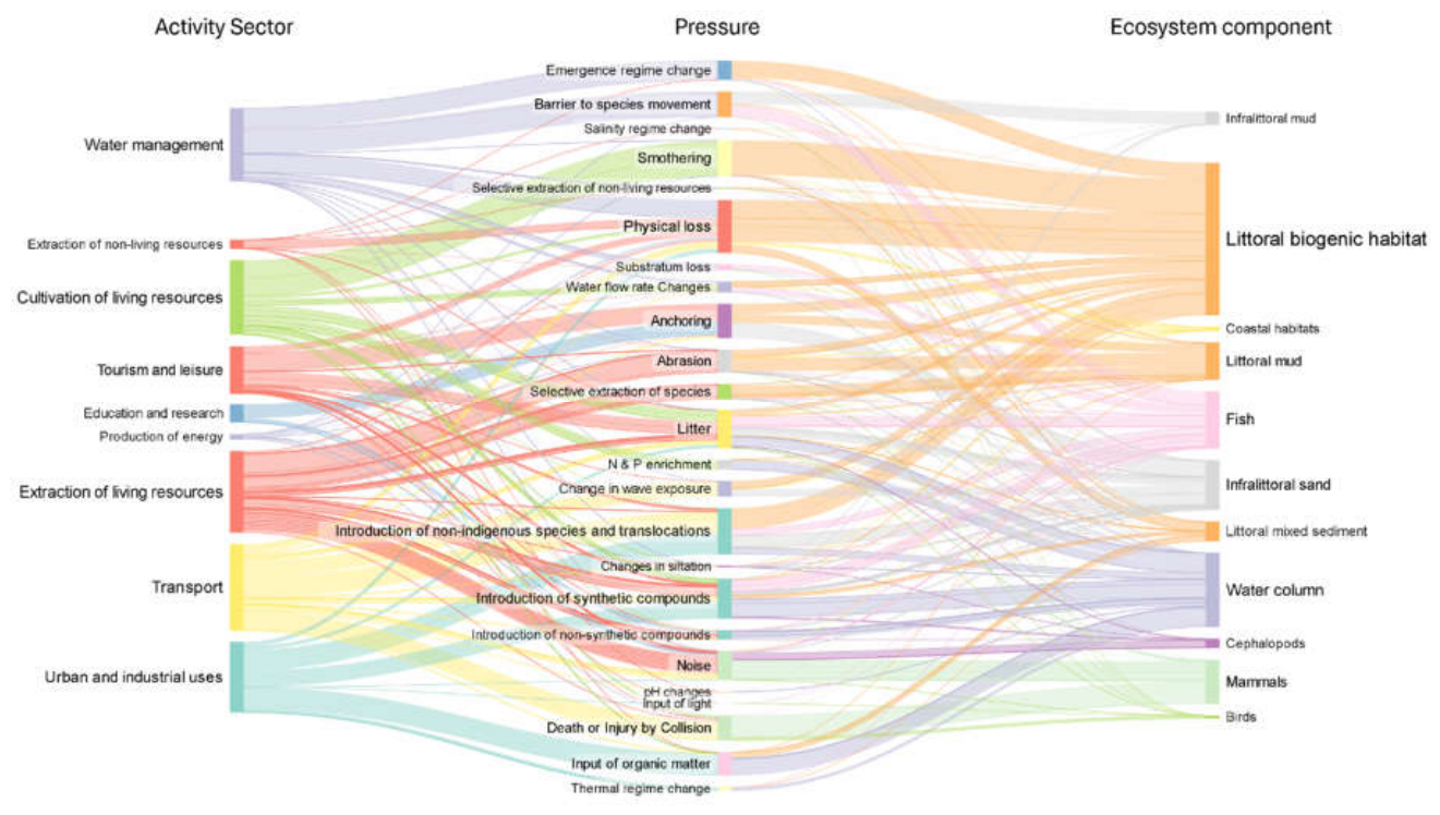
Figure 9.
Contribution of each sector to the total impact risk (IR) of each ecosystem component.
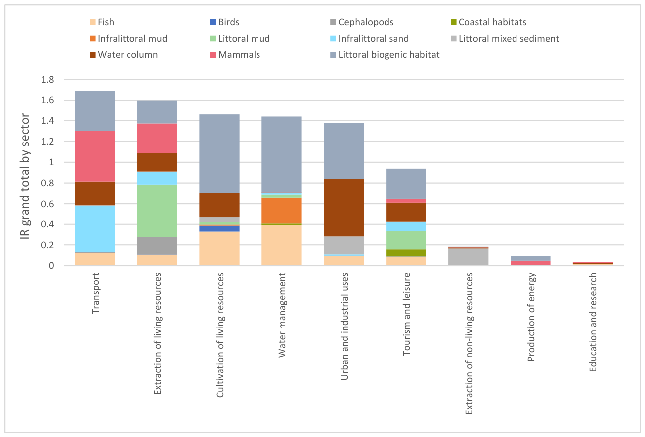
Figure 10.
Contribution of each pressure to the total impact risk (IR) of each ecosystem component.
4. Discussion
This study provides an integrated assessment of the cumulative pressures acting on the Mondego estuary, drawing on the DAPSI(W)R(M) cause-consequence-response framework and a spatially explicit cumulative impact risk approach (SCAIRM). The combined sector-based pressure risk analysis, ecological component clustering and historical context produce a comprehensive picture of how past and present human activities continue to shape ecosystem condition and vulnerability. This approach emphasizes the interplay between socio-economic drivers, sectoral activities and ecological components, highlighting the complexity, heterogeneity and temporal persistence of pressures typical of transitional systems. It is a necessary precursor to (and perhaps the main reason for) defining and implementing relevant and necessary management measures.
To apply both methodologies in the proposed transitional system framework, it is essential to identify what drives local communities to continue developing and developing near to and within these systems. In particular, as with all human developments, is the need for food, shelter and water. In the Mondego estuary, food provision is supported by multiple activities, including fishing and shellfish harvesting. Each activity is then associated with specific pressures, which in turn generate cause–effect relationships affecting ecosystem components. The system can also be examined from the perspective of human activities, ultimately required to give basic needs, allowing a complementary analytical framework. When focusing on needs, the discussion tends to be restricted to subsistence requirements. However, when activities are the primary unit of analysis, additional dimensions emerge, such as tourism or education and research. Tourism, for instance, is not directly linked to basic survival needs and is more commonly associated with higher levels of socio-economic development and personal fulfilment as represented in the results. Education and research not only provide and communicate the information needed to understand and manage the estuary but also increase awareness of its importance locally and nationally. As such, both driver- and activity-based perspectives provide a better comprehensive understanding of human–ecosystem interactions within transitional systems. While SCAIRM conceptualizes impact risk as the consequences of pressures acting on an EC, the conceptual framework characterises the effects on EC as alterations in their natural state (Elliott, 2023; Piet et al., 2023). In contrast, within the DAPSI(W)R(M) framework, following changes to the natural state (EC) impacts are defined with respect to the human domain, encompassing socio-economic goods and benefits, whereas ecosystem services are linked to changes in the state of the ecosystem (Elliott, 2023).
Across all activity sectors in the Mondego estuary, transport-related activities generated the highest relative potential impact risk, reflecting the spatial concentration of navigation and associated infrastructure in the northern arm. Commercial and fishing port facilities, cargo and ferry traffic and recurrent maintenance dredging combine to produce sustained physical disturbance and habitat modification. Maritime transport also serves as a primary pathway for non-indigenous species (NIS) via ballast water. According to the Port of Figueira da Foz Waste Management and Reception Plan (PRGR 2023–2027), oil-contaminated ballast water is collected by tanker trucks since no treatment facilities currently exist. Therefore, management relies largely on vessel-level compliance and offshore exchange procedures. Within the IR modelling framework applied here, the inclusion of fixed treatment infrastructure, in a hypothetical scenario, would reduce the relative IR for biological introductions by approximately 70%, reflecting the sensitivity of the exposure on ecosystem components in the risk assessment. In the absence of such facilities, a residual NIS invasion risk remains associated with maritime traffic. Comparable findings in other estuarine systems identify shipping as a structurally dominant sector where physical alteration and ecological connectivity intersect (Bisinicu et al., 2024).
The extraction of living resources represented the second highest contributor to cumulative risk. This includes artisanal fishing, defined as small-scale conducted by fishing households using low capital and energy, small vessels (if any) and short nearshore trips, primarily for local consumption (FAO, 2015); it also includes recreational fishing, defined as the capture of living aquatic resources mainly for leisure and/or personal consumption (ICES, 2012). These activities generate a combination of biological disturbance, localized sediment disruption and litter inputs, creating pressure across both benthic and pelagic domains. Commercial fishing, primarily aimed at profit rather than for personal consumption or leisure, does not operate inside the estuary (Andersens, 2013), although navigation associated with coastal fishing grounds adds further disturbance. The combined effects of selective harvesting, trampling in shallow habitats and gear-related debris help explain the elevated IR scores observed in littoral mud habitats and water column components. Similar interactions between small-scale fisheries and benthic habitat modification have been reported in other transitional systems (Cabaço et al., 2005; Silvestrini et al., 2025).
Cultivation of living resources, including aquaculture and adjacent agriculture, ranked third in relative impact risk. At Morraceira Island, the shift from salt production to semi-intensive aquaculture has increased pond artificialization, causing habitat conversion, smothering of littoral vegetation and nutrient enrichment. Stock transfers and agricultural runoff introduce non-native species and contribute to eutrophication, particularly in the southern arm, where longer water residence times promote nutrient accumulation. Although water quality has improved, enrichment remains a significant pressure. Similar cumulative effects of aquaculture, agriculture and hydromorphological changes have been observed in other Mediterranean and Atlantic estuaries (Streicher et al., 2021; Domingues et al., 2023).
Hydromorphological restructuring, including dredging and coastal protection measures over past decades, continues to shape tidal dynamics and sediment distribution. Regular dredging maintains navigable conditions for cargo vessels, with dredged sediment now used primarily for beach nourishment or offshore disposal, contributing to elevated IR values from structural alteration. Similar legacy effects of channelization and dredging have been documented in the Scheldt and Guadalquivir estuaries (Temmerman et al., 2013; Sirviente et al., 2023), highlighting that hydromorphological pressures are among the most persistent and least reversible in transitional systems (Elliott and Kennish, 2024).
Urban, industrial and tourism sectors exert more diffuse but cumulatively important pressures. Wastewater effluents, industrial discharge, freshwater extraction and recreational activities contribute synthetic compounds, plastics and physical disturbance to the system. While individual IR scores for these sectors are lower than those for navigation or resource extraction, their dispersed and persistent nature contributes to the cumulative pressure mosaic characteristic of transitional systems.
When examining the distribution of pressures across the system, physical loss, non-indigenous species introduction, synthetic compounds, litter and smothering emerged as the dominant contributors to relative potential IR. The prominence of physical loss reflects the weighting of recovery potential within the cumulative risk framework, as permanent or long-term habitat alteration substantially increases risk magnitude. Similarly, the high ranking of non-indigenous species underscores the structural difficulty of reversing biological invasions once establishment occurs, reinforcing their classification among the most consequential pressures in transitional systems (Elliott and Kennish, 2024; Olenin et al., 2024). In contrast, synthetic compounds and litter represent chronic and diffuse stressors whose cumulative effects operate through persistence, bioaccumulation and sediment retention rather than immediate structural change. Their elevated IR values illustrate how dispersed pressures can generate system-wide consequences despite lower spatial concentration, highlighting the need to address both permanent habitat transformation and long-term contaminant accumulation in transitional system management (Elliott et al., 2022).
The ecosystem components most exposed to potential risk were littoral biogenic habitats, the water column, fish communities, mammals and littoral mud, reflecting differences in both spatial exposure and functional sensitivity. Littoral biogenic habitats, particularly saltmarsh systems, emerge as structurally vulnerable due to their dependence on stable sediment dynamics and hydrological regimes, making them disproportionately affected by permanent or semi-permanent habitat alteration. In contrast, water column processes integrate system-wide diffuse pressures, including nutrient enrichment and contaminants, acting as a conduit through which chemical and particulate stressors propagate across trophic levels. Fish communities reflect compounded effects of structural modification and water quality degradation, as connectivity constraints and pollutant exposure interact to shape movement and recruitment patterns (Whitfield et al., 2022). Mammals are primarily affected by disturbance-related pressures linked to navigation intensity, while littoral mud and associated benthic habitats represent zones of concentrated mechanical disturbance. These patterns illustrate that vulnerability across ecosystem components is not uniform but structured by the interaction between habitat specificity, mobility and exposure domain.
The combined DAPSI(W)R(M) assessment and sector–component clustering reveal that transport, living resource extraction and cultivation of living resources form the dominant pressure node within the Mondego system. The linkage analysis indicates that ecosystem components are structured by two primary pressure domains. The first comprises broadly distributed, system-wide pressures mediated through the water column, connecting mobile and pelagic-related components such as fish communities, infralittoral habitats and marine mammals. The second reflects spatially localized, habitat-specific disturbances concentrated in benthic and shoreline environments, particularly affecting littoral mud and other sediment-dependent habitats. This dual configuration indicates that ecosystem similarity is driven less by sector identity and more by shared exposure pathways. Components influenced by diffuse pressures cluster separately from those shaped by localized structural disturbance. Compared to stronger clustering in Black Sea coastal systems (Bisinicu et al., 2024), Mondego exhibits weaker cohesion among ecosystem components. This pattern suggests a more spatially heterogeneous distribution of pressures, consistent with the smaller scale and mosaic-like configuration typical of transitional estuaries. Such structural fragmentation reinforces the importance of spatially explicit and habitat-targeted management strategies, as cumulative pressures do not propagate uniformly across the system.
While this study has merged the two approaches, SCAIRM and DAPSI(W)R(M), it is notable that the former is a problem-identifying rather than a problem-solving approach such as the latter. Although not explicitly included here, DAPSI(W)R(M) focusses on determining the management measures (the R(M)) after identifying the source of problems (from the D, A and P) and their consequences (on the S and the I(W)) (Elliott et al., 2017). Following this, many of the problems identified here in reducing the environmental quality of the Mondego, have been or are being solved in estuaries worldwide by risk assessment and risk management approaches (Elliott et al., 2022; Lepage et al., 2023; Elliott and Kennish, 2024). In this context, SCAIRM was applied as a diagnostic impact-risk assessment tool to identify priority pressures and sensitive ecosystem components. However, the translation of these findings into management measures corresponds to the Response (R(M)) stage of the framework and lies beyond the scope of the present study. Although outside the current study, there are many mechanisms, including legislation and economic and technical methods, for preventing and/or mitigating the causes of the problems identified on the ecological components. Similarly, there are now many initiatives for remediating and restoring previously damaged estuaries and aiding their recovery from stressors.
5. Concluding Remarks
This study integrates the DAPSI(W)R(M) conceptual framework with the semi-quantitative SCAIRM approach to assess cumulative impact risks in transitional ecosystems. The combined application of both tools enabled identifying the main activity sectors, pressures and ecosystem components contributing to potential impact risk within the Mondego estuary. Transport, extraction and cultivation of living resources, water management, and urban and industrial activities emerged as the principal sectors associated with higher cumulative impact risk, highlighting the convergence of multiple socio-economic uses in generating environmental pressures.
Physical loss and the introduction or translocation of non-indigenous species were identified as pressure key contributors to overall risk, largely influenced by the resilience and recovery components of the SCAIRM scoring system. This indicates that different activity sectors may generate similar types of pressures, which can act cumulatively across EC and increase overall ecological risk. Littoral biogenic habitats, particularly coastal saltmarshes, were identified as the most vulnerable EC due to exposure to multiple overlapping pressures before mentioned. Although non-indigenous species are not currently a dominant issue in the study area, increasing vessel traffic and port development may elevate future invasion risks. In contrast, pressures associated with physical loss and smothering represent more persistent system alterations, with longer recovery times and reduced reversibility, reinforcing the importance of resilience and hazard weighting in SCAIRM impact risk characterisation.
This integrated approach enables prioritising activity sectors, pressures, and ecosystem components associated with higher cumulative impact risk within transitional ecosystems. By combining a conceptual cause–consequence–response structure with a semi-quantitative risk screening, it provides a coherent basis for identifying where cumulative pressures are concentrated and which ecosystem components are most vulnerable. This supports ecosystem-based management by improving the targeting of mitigation and restoration efforts.
However, limitations should be acknowledged: the dependence of SCAIRM on data availability and expert judgement, as well as capturing the complexity of ecological process and spatial heterogeneity of transitional ecosystems. Nevertheless, the integrated framework provides a useful risk-screening and diagnostic tool for supporting estuarine management under data-limited conditions. Future work should focus, firstly, on linking cumulative pressures to habitat condition assessments and ecosystem service delivery to further evaluate ecosystem responses and restoration potential. Secondly, the findings here give a solid grounding necessary to define management responses.
Supplementary Materials
The following supporting information can be downloaded at the website of this paper posted on Preprints.org. Tabel SM1 Score system criteria followed by Bisinicu, et al., 2024 based on (after Piet et al., 2019, Piet et al., 2017, Borgwardt et al., 2019, Piet et al., 2021, Piet et al., 2023, Knights et al., 2015); Table SM 2: Specific activity/operation adapted from the activity themes and corresponding activities are listed from EU (2017b); Table SM 3: Examples of Endogenic Managed Pressures (EnMP) (Smith et al.,2016). Adapted from (Elliott et al., 2017).
Funding
This work had the support of national funds through Fundação para a Ciência e a Tecnologia, I. P (FCT) by the attribution of the PhD grant (2022.12166.BD) to João Fernandes (https://doi.org/10.54499/2022.12166.BD) and by funds granted to MARE (Ref. UID/04292/2025; DOI: https://doi.org/10.54499/UID/04292/2025) and to the Associate Laboratory ARNET (Ref. LA/P/0069/2020; DOI: https://doi.org/10.54499/LA/P/0069/202). It was also supported by the European LIFE Program, through LIFE ADAPT BLUES project (LIFE18 CCA/ES/001160). The contribution by ME was funded by the UKRI through the EU HorizonEurope projects GES4SEAS, MarineSABRES and MARBEFES (EU/UKRI project grant agreements respectively: 101059877/10050522, 101058956/10050525,101060937/10048815).
CRediT Authorship Contribution Statement
João Fernandes: Writing – Review & editing, Writing – original draft, Methodology, Investigation, Formal analysis, Data curation, Conceptualization. Michael Elliott: Writing – Review & editing, Supervision, Methodology, Conceptualization. João Neto: Writing – review & editing, Supervision, Methodology, Validation, Funding acquisition, Conceptualization.
Declaration of Competing Interest
The authors declare that they have no known competing financial interests or personal relationships that could have appeared to influence the work reported in this paper.
Acknowledgements
The authors gratefully acknowledge the participants of this study for their valuable time and responses to the questionnaire.
References
- Alongi, D. M. Carbon balance in salt marsh and mangrove ecosystems: A global synthesis. In Journal of Marine Science and Engineering; MDPI AG, 2020; Vol. 8, Number 10, pp. 1–21. [Google Scholar] [CrossRef]
- Andersens, H. C. Report of the ICES Working Group on Recreational Fisheries Surveys 2013 (WGRFS) 22-26 April 2013 Esporles, Spain International Council for the Exploration of the Sea Conseil International pour l’Exploration de la Mer International Council for the Exploration of the Sea ICES WGRFS REPORT 2013. ICES CM. 2013; Vol. 49, Available online: www.ices.dkinfo@ices.dk.
- Anderson, M. J.; Gorley, R. N.; Clarke, K. R. PERMANOVA+ for PRIMER: Guide to Software and Statistical Methods; 2008. [Google Scholar] [CrossRef]
- Baird, D.; Elliott, M. Treatise on Estuarine and Coastal Science: 7 Volumes, 2nd Edition; Baird, Daniel, Elliott, Michael, Eds.; Elsevier, Academic Press, 2024; Available online: https://www.sciencedirect.com/referencework/9780323910422/treatise-on-estuarine-and-coastal-science-second-edition.
- Basavaiah, N.; Mohite, R. D.; Singare, P. U.; Reddy, A. V. R.; Singhal, R. K.; Blaha, U. Vertical distribution, composition profiles, sources and toxicity assessment of PAH residues in the reclaimed mudflat sediments from the adjacent Thane Creek of Mumbai. Marine Pollution Bulletin 2017, 118(1), 112–124. [Google Scholar] [CrossRef]
- Bisinicu, E.; Abaza, V.; Boicenco, L.; Adrian, F.; Harcota, G. E.; Marin, O.; Oros, A.; Pantea, E.; Spinu, A.; Timofte, F.; Tiganov, G.; Vlas, O.; Lazar, L. Spatial Cumulative Assessment of Impact Risk-Implementing Ecosystem-Based Management for Enhanced Sustainability and Biodiversity in the Black Sea. Sustainability (Switzerland) 2024, 16(11). [Google Scholar] [CrossRef]
- Burdon, D.; Barnard, S.; Boyes, S. J.; Elliott, M. Oil and gas infrastructure decommissioning in marine protected areas: System complexity, analysis and challenges. Marine Pollution Bulletin 2018, 135, 739–758. [Google Scholar] [CrossRef]
- Burke, S. A.; Manahan, J.; Eichelmann, E.; Cott, G. M. Dublin’s saltmarshes contain climate-relevant carbon pools. Frontiers in Marine Science 2022, 9. [Google Scholar] [CrossRef]
- Cabaço, S.; Alexandre, A.; Santos, R. Population-level effects of clam harvesting on the seagrass Zostera noltii. Marine Ecology Progress Series 2005, 298, 123–129. Available online: https://www.int-res.com/abstracts/meps/v298/meps298123. [CrossRef]
- Lee, H.; Romero, J. (Eds.) [Core Writing Team], 2023: Synthesis Report. Contribution of Working Groups I, II and III to the Sixth Assessment Report of the Intergovernmental Panel on Climate Change; IPCC; Geneva, Switzerland; pp. 35–115. [CrossRef]
- Commission Decision (EU) 2017/ 848 - laying down criteria and methodological standards on good environmental status of marine waters and specifications and standardised methods for monitoring and assessment, and repealing Decision 2010/ 477/ EU. Commission Decision (EU) 2017/ 848; 2017.
- Costa, S.; Azeiteiro, U. M.; Pardal, M. A. The contribution of scientific research for integrated coastal management: The Mondego estuary as study case. Revista de Gestão Costeira Integrada 2013, 13(2), 229–241. [Google Scholar] [CrossRef]
- de Jonge, V. N.; Elliott, M.; Orive, E. Causes, historical development, effects and future challenges of a common environmental problem: eutrophication. In Nutrients and Eutrophication in Estuaries and Coastal Waters: Proceedings of the 31st Symposium of the Estuarine and Coastal Sciences Association (ECSA); held in Bilbao, Spain, Orive, E., Elliott, M., de Jonge, V. N., Eds.; Springer Netherlands, 2002; pp. 1–19. [Google Scholar] [CrossRef]
- Defeo, O.; Elliott, M. The ‘triple whammy’ of coasts under threat – Why we should be worried! Marine Pollution Bulletin 2021, 163, 111832. [Google Scholar] [CrossRef]
- Domingues, R. B.; Nogueira, P.; Barbosa, A. B. Co-Limitation of Phytoplankton by N and P in a Shallow Coastal Lagoon (Ria Formosa): Implications for Eutrophication Evaluation. Estuaries and Coasts 2023, 46(6), 1557–1572. [Google Scholar] [CrossRef]
- Elliott, M. Marine Ecosystem Services and Integrated Management: “There’s a crack, a crack in everything, that’s how the light gets in”! Marine Pollution Bulletin 2023, 193, 115177. [Google Scholar] [CrossRef]
- Elliott, M.; Houde, E. D.; Lamberth, S. J.; Lonsdale, J.-A.; Tweedley, J. R. Management of Fishes and Fisheries in Estuaries. In Fish and Fisheries in Estuaries; 2022; pp. 706–797. [Google Scholar] [CrossRef]
- Elliott, M.; Kennish, M. J. 6.1 - A Synthesis of Anthropogenic Impacts and Solutions in Estuarine and Coastal Environments. In Treatise on Estuarine and Coastal Science (Second Edition); Baird, D., Elliott, M., Eds.; Academic Press, 2024; pp. 1–56. [Google Scholar] [CrossRef]
- Elliott, M.; O’Higgins, T. G. From DPSIR the DAPSI(W)R(M) Emergesa Butterfly – ‘protecting the natural stuff and delivering the human stuff. In Ecosystem-Based Management, Ecosystem Services and Aquatic Biodiversity : Theory, Tools and Applications; O’Higgins, T. G., Lago, M., DeWitt, T. H., Eds.; Springer International Publishing, 2020; pp. 61–86. [Google Scholar] [CrossRef]
- European Environment Agency. EUNIS Habitat Typology (Version 2022). 2022. Available online: https://www.eea.europa.eu/.
- EU. Commission Decision (EU) 2017/848 of 17 May 2017 laying down criteria and methodological standards on good environmental status of marine waters and specifications and standardised methods for monitoring and assessment, and repealing Decision 2010/477/EU. Official Journal of the European Union L 125/43, 2017a.
- EU. Commission Decision (EU) 2017/845 of 17 May 2017 amending Directive 2008/56/EC of the European Parliament and of the Council as regards the indicative lists of elements to be taken into account for the preparation of marine strategies. Official Journal of the European Union L 125/27, 2017b.
- FAO. Recreational Fisheries. Technical Guidelines for Responsible Fisheries No. 13.; 2012.
- FAO. Voluntary Guidelines for Securing Sustainable Small-Scale Fisheries in the Context of Food Security and Poverty Eradication; 2015. [Google Scholar]
- Gardoki, J.; Cearreta, A.; Ortiz, J. E.; López-Cilla, I.; Gómez-Arozamena, J.; Villasante-Marcos, V.; Bessa, F.; García-Artola, A.; Irabien, M. J. Assessing the environmental impacts of engineering and agrochemical pollution in a historically-eutrophic estuary: The Mondego case (W Portugal). Marine Pollution Bulletin 2025, 214. [Google Scholar] [CrossRef]
- Glueck, D.; Feußner, N.; Herbst, A.; Schubert, H. Ecological consequences of breakwater and revetment structures on the Baltic Sea Coast in Germany. Aquatic Botany 2025, 198. [Google Scholar] [CrossRef]
- Gulseven, O. Measuring achievements towards SDG 14, life below water, in the United Arab Emirates. Marine Policy 2020, 117, 103972. [Google Scholar] [CrossRef]
- Haines-Young, R. Common International Classification of Ecosystem Services (CICES) V5.2 Guidance on the Application of the Revised Structure. www.cices.eu, 2023.
- Kennish, M. J. Coastal Salt Marsh Systems in the U.S.: A Review of Anthropogenic Impacts. Journal of Coastal Research 2001, 17(3), 731–748. Available online: http://www.jstor.org/stable/4300224.
- Kennish, M. J.; Paerl, H. W.; Crosswell, J. R. Climate change and estuaries (1st Edition); CRC Press, 2023. [Google Scholar] [CrossRef]
- Koss, R.; Knights, A.; Eriksson, A.; Robinson, L.; Abaza, V.; Akoglu, V.; Baulcomb, C.; Böhnke-Henrichs, A.; Breen, P.; Churilova, T.; Cooper, L.; Finenko, Z. osim; Fleming-Lethinen, V.; Fofana, A.; Galil, B.; Goodsir, F.; Goren, M.; Groot, D.; Hussein, S.; Van Tatenhove, J. P. M. ODEMM Linkage Framework Userguide, 2011.
- Li, X.; Bellerby, R.; Craft, C.; Widney, S. E. Coastal wetland loss, consequences, and challenges for restoration. In Anthropocene Coasts; Canadian Science Publishing, 2018; Vol. 1, Number 1, pp. 1–15. [Google Scholar] [CrossRef]
- Modesto, V.; Franco, J. N.; Sousa, R.; Patrício, J.; Marques, J. C.; Neto, J. M. Spatial and temporal dynamics of Corbicula fluminea (Müller, 1774) in relation to environmental variables in the Mondego Estuary (Portugal). Journal of Molluscan Studies 2013, 79(4), 302–309. [Google Scholar] [CrossRef]
- Olenin, S.; Elliott, M.; Minchin, D.; Katsanevakis, S. Marine ecosystem health and biological pollution: reconsidering the paradigm. Marine Pollution Bulletin 2024, 200, 116054. [Google Scholar] [CrossRef]
- PORDATA. Figueira da Foz: área, população residente e densidade populacional; Fundação Francisco Manuel dos Santos, 2024; Available online: https://www.pordata.pt.
- Piet, G.; Bentley, J.; Jongbloed, R.; Grundlehner, A.; Tamis, J.; de Vries, P. A cumulative impact assessment on the marine capacity to supply ecosystem services. Science of The Total Environment 2024, 948, 174149. [Google Scholar] [CrossRef]
- Piet, G.; Grundlehner, A.; Jongbloed, R.; Tamis, J.; de Vries, P. SCAIRM: A spatial cumulative assessment of impact risk for management. Ecological Indicators 2023, 157, 111157. [Google Scholar] [CrossRef]
- Porto da Figueira da Foz. Plano de Receção e Gestão de Resíduos. 2023. Available online: https://portofigueiradafoz.pt/uploads/pdfs/PRGR_2023_2027_APFF_v3_compilada.pdf.
- Salles, D.; Mainguy, G.; Leski, C. The Ecological Restoration of Estuaries. In Estuarine Cities Facing Global Change; 2023; pp. 69–92. [Google Scholar] [CrossRef]
- Schmidt, S.; Neumann, B.; Waweru, Y.; Durussel, C.; Unger, S.; Visbeck, M. SDG14 Conserve and Sustainable Use the Oceans, Seas and Marine Resources for Sustainable Development; 2017; pp. 174–218. [Google Scholar] [CrossRef]
- Silvestrini, C.; Ciccolella, A.; D’Ambrosio, P.; de Franco, F.; Muscogiuri, L.; Fraschetti, S. Small-scale fishery as a driver of habitat loss in marine protected areas. Journal of Environmental Management 2025, 394, 127464. [Google Scholar] [CrossRef]
- Sirviente, S.; Sánchez-Rodríguez, J.; Gomiz-Pascual, J. J.; Bolado-Penagos, M.; Sierra, A.; Ortega, T.; Álvarez, O.; Forja, J.; Bruno, M. A numerical simulation study of the hydrodynamic effects caused by morphological changes in the Guadalquivir River Estuary. Science of The Total Environment 2023, 902, 166084. [Google Scholar] [CrossRef] [PubMed]
- Streicher, M. D.; Reiss, H.; Reiss, K. Impact of aquaculture and agriculture nutrient sources on macroalgae in a bioassay study. Marine Pollution Bulletin 2021, 173, 113025. [Google Scholar] [CrossRef]
- Temmerman, S.; Meire, P.; Bouma, T. J.; Herman, P. M. J.; Ysebaert, T.; De Vriend, H. J. Ecosystem-based coastal defence in the face of global change. Nature 2013, 504(7478), 79–83. [Google Scholar] [CrossRef] [PubMed]
- Whitfield, A. K.; Elliott, M.; Blaber, S. J. M.; Able, K. W. Fish and fisheries in estuaries : a global perspective; John Wiley & Sons, Inc., 2022; Available online: https://onlinelibrary.wiley.com/doi/book/10.1002/9781119705345?msockid=1075f3ec8d2966be2cade7778c9d6709.
Figure 1.
Mondego estuary anthropogenic activities and system habitats.
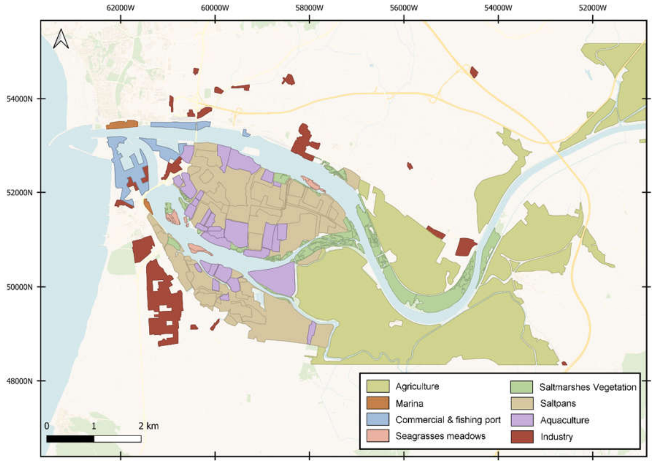
Figure 2.
Historical Development of Human Activities at Figueira da Foz, Portugal.
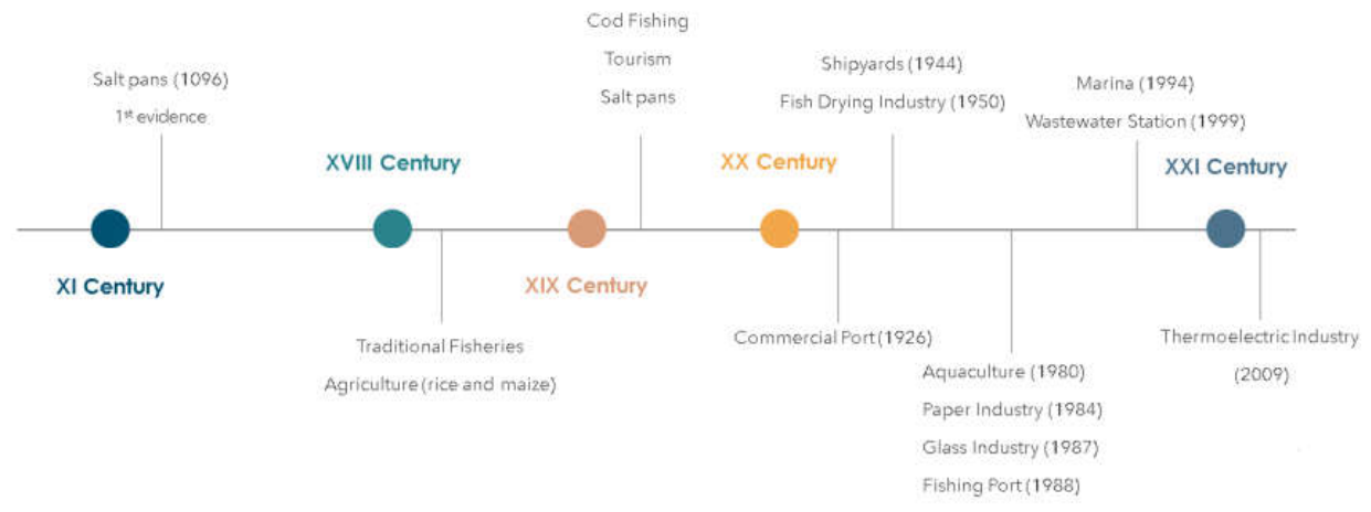
Figure 3.
Integrating Conceptual framework DAPSI(W)R(M) with cumulative IR assessment SCAIRM.
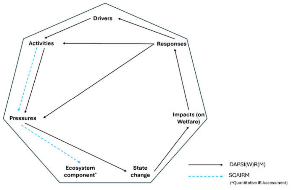
Figure 4.
Percentage of IR grand total by activities sector at the Mondego estuary.
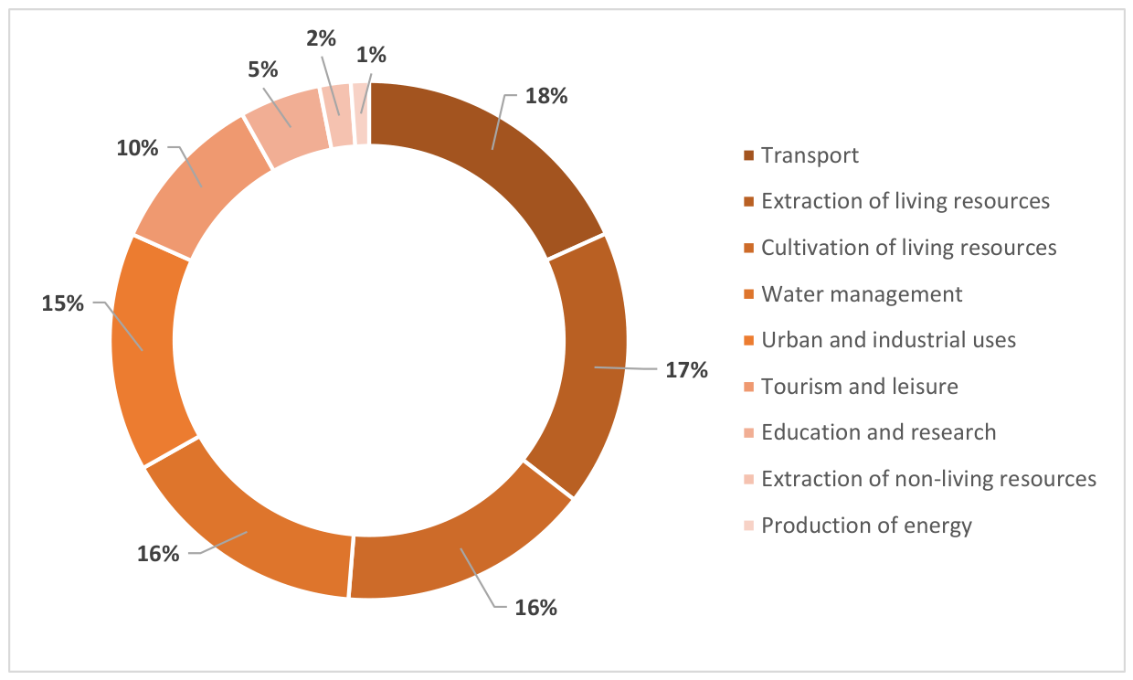
Figure 5.
Percentage of impact risk (IR) grand total by pressures at the Mondego estuary.
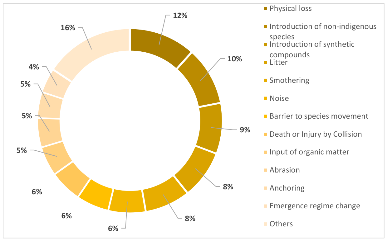
Figure 6.
Bray–Curtis similarity based on sector on the ecosystem components at Mondego estuary. Symbols indicate the activity sector with the highest relative IR associated with each EC.
Figure 6.
Bray–Curtis similarity based on sector on the ecosystem components at Mondego estuary. Symbols indicate the activity sector with the highest relative IR associated with each EC.
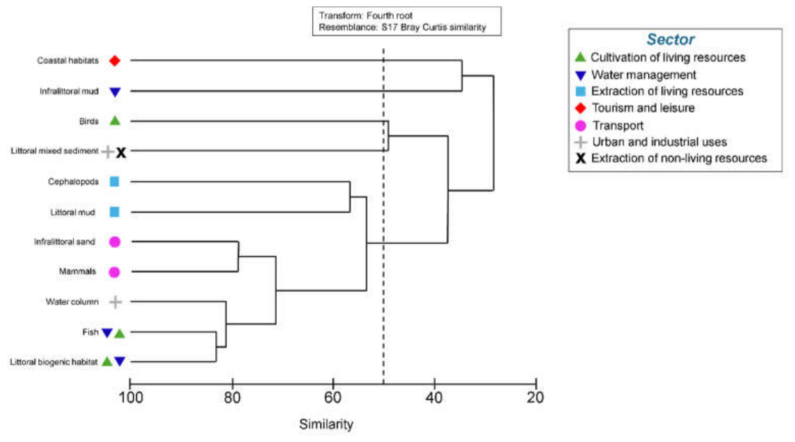
Figure 7.
Bray–Curtis similarity based on pressures on the ecosystem components at Mondego estuary. Symbols indicate the pressure with the highest relative IR associated with each EC.
Figure 7.
Bray–Curtis similarity based on pressures on the ecosystem components at Mondego estuary. Symbols indicate the pressure with the highest relative IR associated with each EC.
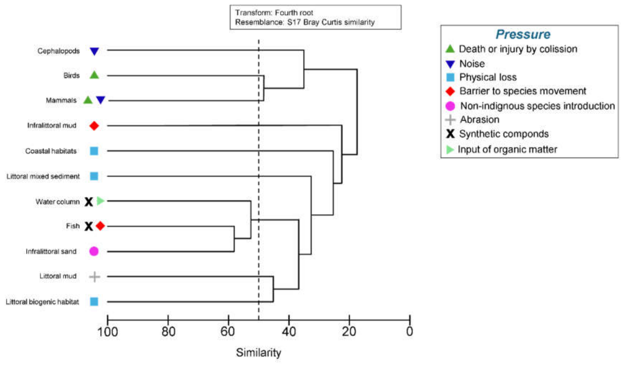

Table 1.
Identification of (D) Drivers and related (A) Activity sectors in the Mondego estuary.
| Maslow’s level | Driver | Activity Sector MSFD |
| Basic needs (1) | Water | Water management, Extraction of non-living resources. |
| Basic needs (1) | Food | Cultivation of living resources, Extraction of living resources. |
| Basic needs (1) | Energy | Production of energy. |
| Basic needs (1) | Shelter | Urban and industrial uses. |
| Safety needs (2) | Health & welfare | Urban and industrial uses. |
| Safety needs (2) | Protection | Water management. |
| Safety needs (2) | Mobility | Water management, Transport. |
| Psychological needs (3) | Supply of goods | Water management, Extraction of non-living resources, Transport. |
| Self-fulfilment needs (5) | Knowledge | Education and research, Tourism and leisure. |
| Self-fulfilment needs (5) | Leisure | Tourism and leisure, Extraction of living resources, Extraction of non-living resources, Tourism and leisure infrastructures. |
Disclaimer/Publisher’s Note: The statements, opinions and data contained in all publications are solely those of the individual author(s) and contributor(s) and not of MDPI and/or the editor(s). MDPI and/or the editor(s) disclaim responsibility for any injury to people or property resulting from any ideas, methods, instructions or products referred to in the content. |
© 2026 by the authors. Licensee MDPI, Basel, Switzerland. This article is an open access article distributed under the terms and conditions of the Creative Commons Attribution (CC BY) license (http://creativecommons.org/licenses/by/4.0/).
Copyright: This open access article is published under a Creative Commons CC BY 4.0 license, which permit the free download, distribution, and reuse, provided that the author and preprint are cited in any reuse.


