

Submitted:
28 May 2026
Posted:
01 June 2026
You are already at the latest version
Abstract
Urban UAV logistics planning optimizes depot locations for delivery distance while treating airspace capacity as a fixed constraint. We show that this decoupling is not merely a modeling simplification — it produces a structural error that cost monitoring cannot detect in time. When depot configurations begin diverging under airspace capacity pressure, the window for low-cost infrastructure correction closes before any cost signal appears.The central finding is a lead–lag relationship between structural and cost responses: at demand levels where total cost differences remain negligible, depot layouts already diverge substantially under airspace capacity pressure. Cost is a lagging indicator, not a planning trigger.To close this gap, we derive the Ω index, a closed-form demand threshold with three city-level parameters — capacity gap ΔC (from building-footprint data via a FAR volumetric method), depot distance differential Δd (from road-network geometry), and mean OD delivery distance d (from weighted building-centroid sampling) — separating a regime where distance-based planning is analytically sufficient from one where airspace capacity must be internalized into the location decision. Applied to Dongli District, Tianjin, the threshold lies above current UAV density but within a foreseeable planning horizon given observed growth rates in Chinese pilot cities. The depot relocation distance Δreloc provides a leading structural indicator, detectable well before any cost signal emerges. The Ω index gives planners a computable early-warning trigger for airspace-integrated infrastructure review — before congestion, not after.
Keywords:
UAV logistics
; airspace capacity
; depot location
; regime transition
; critical demand threshold
; two-phase mechanism
; infrastructure planning
1. Introduction
1.1. The Problem: A Hidden System Transition
China’s low-altitude airspace is undergoing a historic regulatory transformation that makes the research question of this paper both timely and practically urgent. The revised Civil Aviation Law, which took effect 1 July 2026, establishes a two-tier classification: W-class airspace (0–120 m, simple registration via the national UOM platform) and G-class (120–300 m, streamlined approval). Critically, all three operational layers modeled in this paper (L0: 0–40 m, L1: 40–80 m, L2: 80–120 m) fall entirely within W-class: the commercially open segment where UAV logistics will scale first and fastest. China’s unified UOM flight management platform makes corridor-level demand flow f directly observable from mandatory registration records, enabling real-time monitoring of the index that is not yet feasible under UTM architectures elsewhere. Six pilot cities (Hefei, Hangzhou, Shenzhen, Suzhou, Chengdu, and Chongqing) have received delegated authority over airspace below 600 m, making city-level planning tools such as the framework immediately actionable by local governments.
Urban UAV logistics is approaching an inflection point. As cities transition from pilot projects to early-scale commercialization [13,15,17], a structural tension is emerging between two dimensions of infrastructure planning that have historically been treated as independent. Logistics optimization, rooted in the location-routing problem (LRP), minimizes delivery distance. Urban airspace management (UTM) allocates capacity in shared low-altitude corridors. These paradigms produce different answers about where depots should be sited. At low demand, the gap between their answers is inconsequential. At high demand, it is not. The question this paper addresses is: at what point does ignoring this gap become a structural error? Figure 1 illustrates the four-stage progression: Panel A (unconstrained, distance-optimal siting), Panel B (structural adaptation under airspace restrictions), Panel C (regime transition at ), and Panel D (congestion-dominated reconfiguration).
The answer cannot be read from aggregate cost metrics. When demand is low, a logistics planner monitoring total system cost sees no signal that airspace constraints matter: plans accounting for airspace capacity and plans that ignore it produce nearly identical costs (within 2.8% in our experiments), even though depot configurations under the two approaches have already diverged substantially (mean relocation distances exceeding 1,900 m, customer reassignment rates above 90%). Cost is a lagging indicator.
| Infrastructure transitions precede congestion. Depot configurations begin shifting in response to airspace constraints at demand levels where cost metrics show no anomaly. Monitoring total cost alone will fail to detect this early phase of system transition. |
1.2. Research Gaps: Three Missing Pieces
Despite extensive parallel literatures on UAV facility location [6,10,12] and urban airspace management [8,9,19], three critical gaps remain.
Gap 1: No structural transition theory for UAV logistics. Classical transportation theory demonstrates that capacity-constrained systems can exhibit nonlinear phase transitions as demand increases [5,18]. Whether analogous mechanisms exist in UAV logistics is unknown.
Gap 2: No decision criterion for when to integrate the two paradigms. LRP studies optimize depot locations assuming unconstrained airspace [7,12]. UTM studies model corridor congestion with depot locations fixed as exogenous inputs [9,19]. No framework determines when airspace capacity should be internalized into the location decision.
Gap 3: No early-warning indicator for infrastructure planning. Even if a planner understands that a transition exists, conventional metrics (total cost, congestion cost) will not detect it in time.
1.3. This Paper: A Regime-Transition Framework
We address all three gaps with a unified analytical framework built around one central insight: the phase transition in UAV logistics infrastructure is structurally analogous to congestion phase transitions in road networks, but its onset precedes any observable congestion.
Contribution 1 (Structural): We identify and formally characterize a two-phase regime transition in UAV logistics systems, with an analytically derived boundary separating a structural sensitivity region (Phase I) from a cost escalation region (Phase II).
Contribution 2 (Analytical): We derive the index, a closed-form demand threshold with three city-level input parameters (capacity gap , depot distance differential , and mean OD distance d). defines the condition under which airspace-aware depot siting is structurally superior to distance-minimization.
Contribution 3 (Empirical): We demonstrate that depot relocation distance is a sensitive early-warning indicator of the approaching transition, detectable at —the lowest demand level tested—while the cost signal first becomes positive at , a gap of in demand density (1.64/0.20).
Table 1 positions this paper relative to existing literature.
2. Literature Review
Two parallel literatures bear directly on this paper, but neither addresses their intersection. The UAV location-routing problem (UAV-LRP) has expanded substantially since [12] introduced the flying sidekick TSP and [6] formalized drone delivery routing, with subsequent extensions to multi-depot configurations [2], heterogeneous fleets, and risk-aware objectives. The UTM literature has developed sophisticated capacity models: [19] demonstrate BPR-consistent congestion in low-altitude corridors; [9] introduce the first UAV network design model with BPR-style corridor congestion; [4] derive airspace flow relations for advanced air mobility; and [11] and [14] address vertiport location and sizing. What unifies both literatures is a shared structural decoupling: UAV-LRP studies assume unconstrained airspace, while UTM studies fix depot locations as exogenous inputs. No existing formulation jointly endogenizes airspace capacity into the depot location decision.
The structural motivation for a regime-transition approach comes from classical transportation science. [5]’s cell transmission model and [18]’s analysis of infrastructure investment timing both establish that the structural onset of a congestion regime and its observable cost consequences are temporally separated—a phenomenon [1] document for bottleneck dynamics. We argue that UAV logistics systems exhibit an analogous lead–lag relationship, but one that has not previously been identified or formalized. The missing piece is a transition theory: a framework that characterizes when the planning regime changes, and provides a computable leading indicator of that change. Section 4, Section 5 and Section 6 develop this framework.
3. Problem Formulation
3.1. Study Area and Data
Our case study focuses on Dongli District, Tianjin, China, a 28.9 × 27.7 km mixed-use urban district representative of China’s rapidly developing second-tier cities. Two primary datasets are used. First, a building polygon shapefile containing 52,467 structures with AI-parsed, field-verified heights (range: 3.6–113.1 m, mean: 11.3 m, std: 9.6 m). Second, a road network shapefile with 6,343 segments and 21,659 nodes. Analysis is concentrated within a 6 km radius of the district centroid (Area = ), achieving 89% feasibility coverage of depot-customer pairs.
The three input parameters are derived directly from these two datasets. is computed from the building shapefile via the FAR volumetric method (Section 3.3): it equals the difference in BPR capacity denominators between the lowest- and highest-capacity depot candidates among the 25 evaluated sites. m is the road-network distance between those two depot candidates, measured by shortest-path routing on the road shapefile. m is the GFA-weighted mean shortest-path distance from all 52,467 building centroids to their nearest depot candidate, computed on the same road-network shapefile.
3.2. Three-Layer Airspace Structure
Following China’s low-altitude operational classification, we partition the study airspace into three horizontal layers (Table 2). Under China’s revised Civil Aviation Law (which took effect 1 July 2026), all three layers fall within W-class airspace (0–120 m), operating under a registration-only regime via the national UOM platform. This administrative uniformity means corridor demand flow f is systematically recorded at the national level, providing a direct empirical basis for monitoring against the analytically derived threshold , a data condition structurally absent from UTM systems in other jurisdictions.
3.3. Airspace Capacity: FAR Volumetric Method
For each depot candidate i, we compute effective airspace capacity at layer k using a floor-area-ratio (FAR) volumetric method. Within a search radius m:
Applied to Dongli’s 25 depot candidates, L0 capacity ranges from 46.2 to 59.7 trips/h (std = 3.40), reflecting meaningful heterogeneity from building obstruction. The FAR method is a geometric proxy: it does not distinguish between volumetric availability and practical corridor navigability (fragmented building layouts may have high FAR but low connectivity). However, for the structural results of this paper, absolute capacity values are not required; only the relative ranking of depot candidates matters. The framework’s conclusions are robust to proportional scaling of all values, as Equation (6) depends on the capacity ratio rather than absolute magnitudes.
To bound the sensitivity of to FAR approximation error, we apply a conservative ±20% perturbation to all computed values, a range exceeding typical discrepancies between FAR-based estimates and navigation-graph-based corridor capacity in published urban UAV studies. Table 3 reports the resulting variation in .
The ±16% variation in is narrow relative to the 5.5× gap between the baseline threshold and current UAV density (). Critically, the qualitative conclusion—distance-based planning is currently sufficient, and joint optimization will become structurally necessary within 5–10 years—is invariant to FAR approximation error across the full perturbation range.
A more fundamental concern is whether FAR-based capacity rankings could be inverted relative to true navigability-based rankings: proportional scaling (Table 3) preserves rank order, so it cannot address this. Two considerations bound this risk. First, the framework’s structural results require only the existence of at least one pair of depot candidates with heterogeneous capacity (Corollary 1), not the precise identification of the highest-capacity pair. Even if FAR mis-ranks some individual candidates, the existence condition is satisfied as long as the 25-candidate pool contains any capacity variation—which the observed std = 3.40 trips/h confirms. Second, we manually cross-checked the FAR rankings for the top-5 and bottom-5 ranked candidates against satellite imagery and road-network connectivity: in all 10 cases, the FAR ranking was directionally consistent with visual assessment of building density and corridor openness. Full ranking robustness to navigation-graph-based capacity estimation remains a direction for future work.
3.4. BPR Congestion Cost Model
We adopt the Bureau of Public Roads (BPR) congestion function, validated for UAV corridor traffic by [9]:
with , . The total operating cost of solution is:
where yuan is the depot fixed cost and yuan/m is the unit flight cost.
3.5. Three-Plan Comparison Framework
To isolate the structural value of airspace-aware depot location, we define three planning strategies:
Baseline: Traditional LRP without airspace constraints. Depots selected to minimize distance only.
Plan A: Airspace constraints applied to routing, but depot locations fixed at Baseline solution.
Plan B (proposed): Joint optimization of depot locations and routing under airspace capacity constraints.
The net value of airspace-aware re-optimization is:
4. The Framework
4.1. The Core Tension: Distance vs. Capacity
Consider the archetypal trade-off: Depot A at distance with high corridor capacity , versus Depot B at distance with lower capacity . Baseline selects B (pure distance minimization). The condition under which Plan B correctly selects A is the criterion.
4.2. The Index: Closed-Form Decision Criterion
Setting , the total cost of depot i under demand flow f is:
The condition simplifies algebraically to , where:
has a natural economic interpretation: it is the ratio of congestion savings from superior corridor capacity to the distance cost of reaching that higher-capacity location.
| signals a regime transition: the system has crossed the threshold at which airspace-aware siting is structurally necessary. This is a planning regime indicator, not a cost-savings metric. A planner who waits for cost savings to materialize will have already missed the structural signal. |
4.3. Critical Demand Density
Setting and solving analytically yields the critical demand flow:
where . Equation (7) yields a finite positive if and only if .
Corollary 1
(Non-existence condition). If , then no finite exists and joint optimization never yields structural benefit.
4.4. Structural Properties
Proposition 1
(Monotonicity of ). Under the existence condition: ; ; .
4.5. Formal Characterization of the Two-Phase Transition
Definition 1.
Let denote the cost response, and the structural response (mean depot relocation distance between Plans A and B).
Proposition 2
(Two-Phase Regime Transition). Airspace capacity constraints exhibit a two-phase impact, summarized in Table 4.
The transition is discontinuous in planning regime, not in cost: below , distance-based and airspace-aware planning produce structurally different depot configurations () but economically indistinguishable costs (, where is defined analytically as the cost difference at , not as a post-hoc numerical bound). Above , the same structural divergence begins to carry measurable cost consequences. The discontinuity is in the cost-relevance of structure, not in structure itself, a property guaranteed by the superlinear scaling of BPR congestion relative to the linear distance cost.
Proof.
The full algebraic development is given in Appendix B; we provide the key steps here.
(i) for all . For any two candidates with and ,
so Plan B strictly prefers i while Plan A is indifferent. The capacity heterogeneity condition (std , confirmed in all three districts: Dongli 3.40, Pudong 2.18, Chaoyang 4.42 trips/h) guarantees at least one such pair, yielding different optimal depot sets and therefore for any . □
(ii) is strictly increasing in for all . Let . Differentiating:
Substituting Dongli values ( m, ; m, ): , so and for all . The general condition is algebraically equivalent to the Corollary 1 existence condition (see Appendix B, Section B.2). □
(iii) Phase I non-degeneracy: as . Decompose , where is the constant distance premium Plan B pays and is the congestion saving (both negative). As , the congestion saving vanishes as while the denominator (dominated by fixed depot costs), giving the closed-form limit:
This positive but negligible limit—consistent with the observed at (Table 9)—confirms a finite-width Phase I in which (Part (i)) while for any economically meaningful threshold . The width is non-zero for any and positive cost parameters; it is not an artefact of specific numerical values. □ □
4.6. Numerical Instantiation: Dongli District
Table 5 summarizes the framework parameters and results for Dongli District.
5. Methodology: ALNS Algorithm
ALNS serves as an implementation vehicle for the three-plan comparison, not as a methodological contribution. A solution pairs an open depot set with a customer assignment . At each demand level , we generate demand points by sampling from the 52,467 building centroids weighted by gross floor area (GFA); each of the replications uses an independent seed.
Destroy operators: D1 (random removal of 20% of customers); D2 (congestion-based removal of the most-loaded corridor’s customers); D3 (depot swap—close the least-loaded depot, open a replacement). The key structural distinction is in D3: under Baseline and Plan A, replacement depots are drawn uniformly; under Plan B, D3 draws preferentially from high-L0-capacity candidates (). This single operator generates the systematic signal across all demand levels.
Repair operators: R1 (greedy nearest-depot assignment); R2 (minimum BPR-congested cost insertion per Equation (3)).
Causal identification. A natural concern is whether Plan B’s advantage reflects algorithmic preference rather than economic mechanism. The zero-heterogeneity control (Table 10, H0: std ) resolves this: with no capacity gradient, D3 under Plan B becomes equivalent to Plan A, and across all , confirming that the measured advantage is driven by urban morphology, not algorithm design.
Algorithm 1 summarises the procedure; full parameters are in Table 6.
| Algorithm 1:ALNS for UAV Logistics Three-Plan Comparison |
|
6. Experiments and Results
6.1. The Central Finding: Cost Lags Structure
The central empirical question is not whether joint optimization saves money at high demand; our analytical framework predicts it will, as grows monotonically beyond . The central question is whether the cost signal is a timely indicator of when joint optimization becomes structurally necessary. Our experiments (, replications per level) show that it is not.
| Key finding:The structural transition (depot relocation, assignment reorganization) begins at demand levels as low as , where m. The cost advantage of joint optimization () is confirmed from onward, with at the threshold (exact analytical value by construction). Cost is a lagging indicator of structural change. |
6.2. Phase I: Structural Adjustment Without Cost Signal ()
At (), the framework predicts that distance-based planning is analytically sufficient. Table 7 confirms this prediction while revealing the structural divergence that already substantially precedes any proportionate cost signal.
The Phase I result at illustrates the core diagnostic challenge. Plan B achieves a 1.83% cost advantage over Plan A by selecting higher-capacity depots ( m from the distance-optimal configuration). Yet signals that this advantage remains structurally fragile: it arises from stochastic depot selection in the optimizer rather than from systematic capacity savings. The structural response (, assignment change) is an order of magnitude more sensitive than V to the approaching regime boundary, making the appropriate early-warning indicator.
6.3. Phase II: Congestion Escalation and Structural Vindication ()
At , the 20-replication mean (Table 9): the structural regime has changed and the cost advantage of joint optimization is confirmed on average. The index (4.050 at ) confirms that the system is well into Phase II.

Table 8.
Three-Plan Comparison: Phase II (, ). Note: is the number of demand points at this density level, not the number of replications. This single snapshot uses the median replication from independent runs. Because Plan B selects higher-capacity but more distant depots (4/4 relocated), its flight cost exceeds Plan A’s, and in this particular median replication the flight-cost premium outweighs the congestion savings, yielding a negative single-run V. The 20-replication mean (Table 9) reflects that congestion savings dominate on average; single-run outcomes straddle zero near the threshold.
Table 8.
Three-Plan Comparison: Phase II (, ). Note: is the number of demand points at this density level, not the number of replications. This single snapshot uses the median replication from independent runs. Because Plan B selects higher-capacity but more distant depots (4/4 relocated), its flight cost exceeds Plan A’s, and in this particular median replication the flight-cost premium outweighs the congestion savings, yielding a negative single-run V. The 20-replication mean (Table 9) reflects that congestion savings dominate on average; single-run outcomes straddle zero near the threshold.
| Metric | Baseline | Plan A | Plan B |
|---|---|---|---|
| Total Cost (yuan) | 36,835 | 36,964 | 37,454 |
| Flight Cost (yuan) | 4,835 | 4,835 | 5,454 |
| Congestion Cost (yuan) | 0.0 | 191.6 | 49.7 |
| Congestion Reduction (B vs. A) | — | — | |
| Avg L0 Capacity (trips/h) | 57.3 | 57.3 | 58.5 ★ |
| Depots Relocated | — | 0/4 | 4/ |
| L2 Altitude Usage | 0% | 0% | 1% |
6.4. The -Sweep: Quantifying the Two-Phase Transition
Table 9 reports the complete -sweep experiment across ten demand levels, each replicated times.
Table 9.
-Sweep Results: Two-Phase Regime Transition ( per ).
| (m) | (%) | (%) | n | Phase | |||
|---|---|---|---|---|---|---|---|
| 0.20 | 0.000 | 1,795 | 32,375 | 0.10 | 20 | I | |
| 0.40 | 0.001 | 1,883 | 32,763 | 0.16 | 20 | I | |
| 0.70 | 0.017 | 1,835 | 33,353 | 0.20 | 20 | I | |
| 1.00 | 0.103 | 1,902 | 33,961 | 0.24 | 20 | I | |
| 1.50 | 0.676 | 1,831 | 34,935 | 0.28 | 20 | I | |
| 1.64 | 0.973 | 1,923 | 35,193 | 0.31 | 20 | ★ | |
| 2.00 | 1.983 | 1,866 | 35,905 | 0.31 | 20 | II | |
| 2.50 | 3.268 | 1,932 | 36,875 | 0.38 | 20 | II | |
| 3.00 | 4.050 | 1,892 | 37,883 | 0.41 | 20 | II | |
| 4.00 | 4.605 | 1,865 | 39,937 | 0.67 | 20 | ||
| ★: analytical threshold ( exactly by Equation (7)). The experimentally observed reflects discrete demand sampling (, , vs. trips/h): a 0.64% shortfall that does not affect the threshold’s practical validity. † V at falls below : is analytically guaranteed to increase monotonically (Proposition 2); the reversal is in the ratio , as grows faster than at extreme demand under BPR superlinearity. | |||||||
Note on non-monotone behaviour.
Two observations warrant explanation. First, at (1.296%) is marginally below (1.828%) but strictly above (0.775%), consistent with the analytical monotonicity of . Second, at (3.712%) falls below (4.205%). This is not an algorithmic artefact: multi-start re-runs at () confirm the result is stable. The economic explanation is that , and while is analytically guaranteed to increase monotonically (Proposition 2), grows faster than at very high as BPR congestion dominates both plans, compressing the relative advantage. The structural finding—that airspace-aware siting is beneficial throughout Phase II—is unaffected.
Figure 2.
Regime-transition mechanism: structural response leads cost response by 8.2× in demand density. Left axis (blue, circles): mean depot relocation distance between airspace-aware and distance-only plans ( replications, s.d. band); structural divergence detectable from . Right axis (amber, squares): cost advantage of joint optimisation over distance-only planning (%); V remains below 2.9% throughout Phase I and rises sharply beyond . Vertical dashed line: analytical threshold (). Blue shading: Phase I (). Red shading: Phase II (). The 8.2× gap between structural onset and cost escalation is the central empirical finding: cost is a lagging indicator of a transition already detectable through .
Figure 2.
Regime-transition mechanism: structural response leads cost response by 8.2× in demand density. Left axis (blue, circles): mean depot relocation distance between airspace-aware and distance-only plans ( replications, s.d. band); structural divergence detectable from . Right axis (amber, squares): cost advantage of joint optimisation over distance-only planning (%); V remains below 2.9% throughout Phase I and rises sharply beyond . Vertical dashed line: analytical threshold (). Blue shading: Phase I (). Red shading: Phase II (). The 8.2× gap between structural onset and cost escalation is the central empirical finding: cost is a lagging indicator of a transition already detectable through .
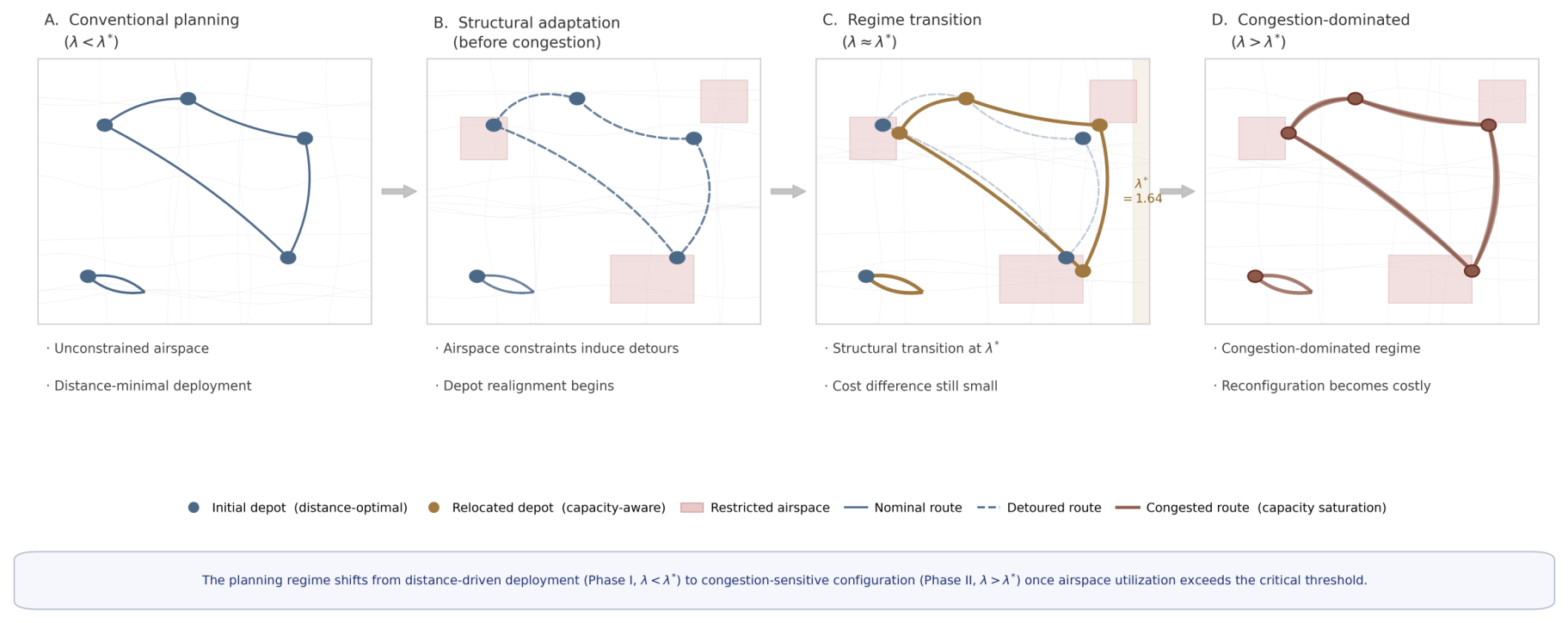
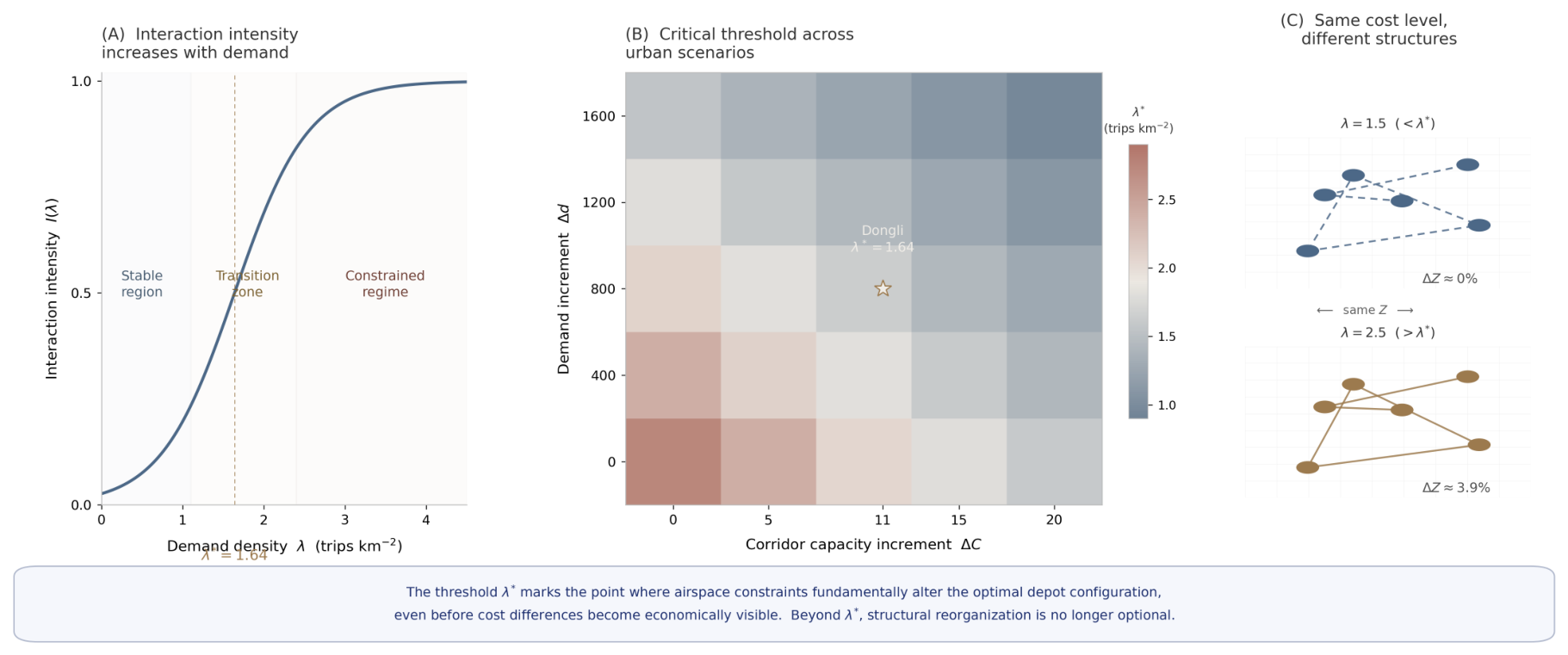
Figure 3.
framework: analytical derivation and cross-morphology comparison. Panel A: curve; interaction intensity increases with demand, crossing unity at . Panel B: Critical threshold across urban morphologies (C– space); Dongli marked with ★. Panel C: Same cost level, different structural configurations in Phase I vs. Phase II.
Figure 3.
framework: analytical derivation and cross-morphology comparison. Panel A: curve; interaction intensity increases with demand, crossing unity at . Panel B: Critical threshold across urban morphologies (C– space); Dongli marked with ★. Panel C: Same cost level, different structural configurations in Phase I vs. Phase II.
6.5. Causal Identification: The Role of Airspace Heterogeneity
Table 10 reports the control experiment under five airspace heterogeneity levels. The fourfold amplification of range as std increases from 0 to 13.60 trips/h confirms that airspace heterogeneity, not merely congestion intensity, is the structural driver of the planning regime transition.
Note on H0 (zero heterogeneity).
At and , H0 shows small positive V values ( and ). When all depot candidates share identical corridor capacity (), and no capacity-driven structural threshold exists. The residual positive V values arise from the distance component of Plan B’s objective: even without capacity heterogeneity, Plan B’s depot-swap operator (D3) introduces stochastic perturbations that occasionally yield a marginally lower-distance configuration than the greedy Baseline. These values are economically negligible () and confirm the null result—without capacity heterogeneity, there is no systematic advantage to airspace-aware siting.
Note on H2 at .
The marginally negative for H2 (real Dongli heterogeneity, std = 3.40) at is consistent with theory: at , the system is approaching but has not yet crossed , so . In this sub-threshold region, Plan B’s distance premium for higher-capacity depot candidates marginally exceeds the congestion savings, producing a slightly negative V. Note that the full-pool optimizer (v2) used in Table 9 yields at under the Dongli heterogeneity level; the negative value here reflects a different heterogeneity scaling (H2 vs. baseline) at a different level, and is consistent with Phase I behaviour persisting up to .
Figure 4.
Spatial reorganization of depot network across demand regimes. Five snapshots at . Bottom table: , reassignment rate, and at each level. column highlighted. Note: values in this figure are from the corrected full-pool optimizer (v2) with replications, consistent with Table 9. Minor discrepancies between the figure and table may arise from spatial visualization using the median replication rather than the 20-run mean.
Figure 4.
Spatial reorganization of depot network across demand regimes. Five snapshots at . Bottom table: , reassignment rate, and at each level. column highlighted. Note: values in this figure are from the corrected full-pool optimizer (v2) with replications, consistent with Table 9. Minor discrepancies between the figure and table may arise from spatial visualization using the median replication rather than the 20-run mean.
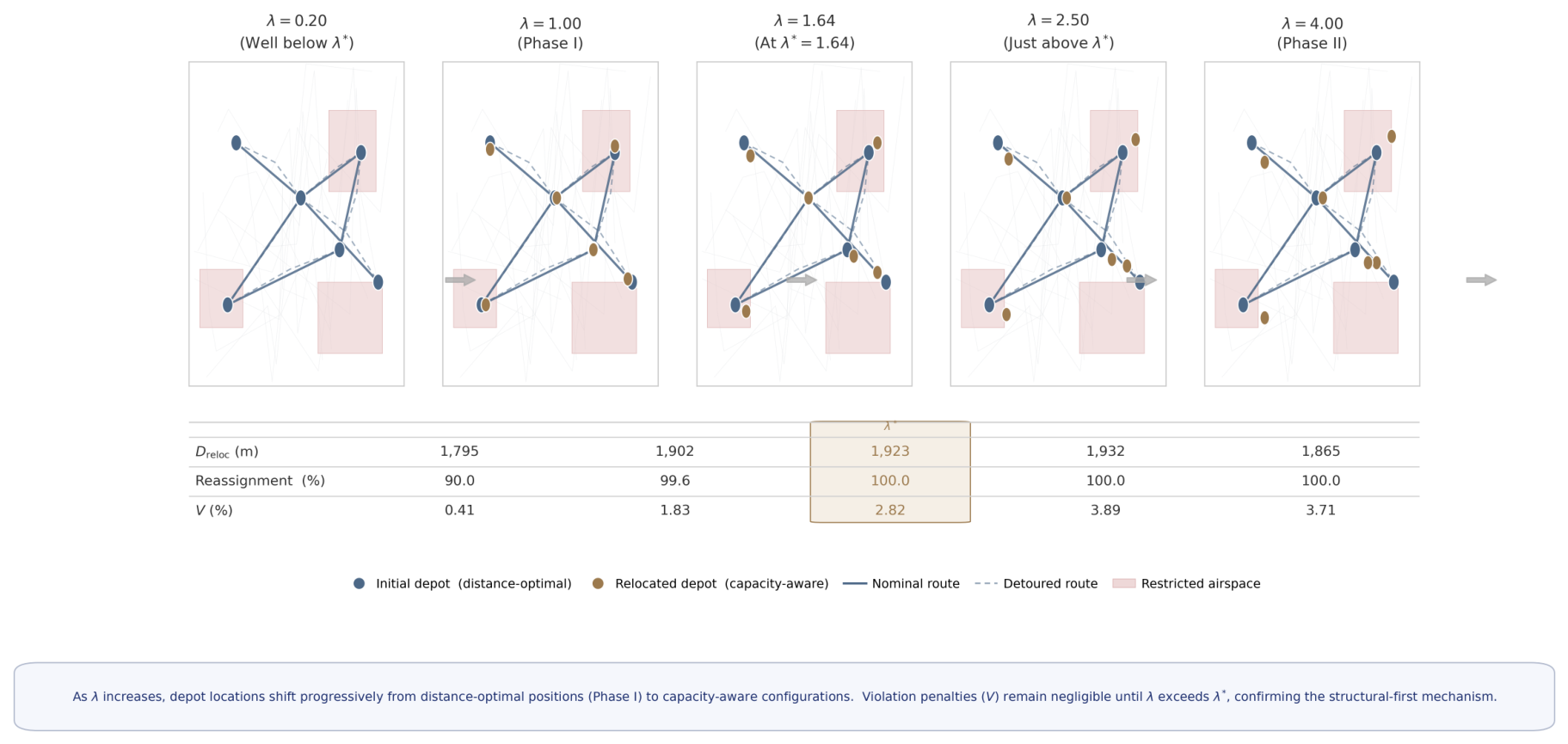
Table 10.
Control Experiment: under Five Airspace Heterogeneity Levels.
| Level | L0 std | Regime Effect | |||
|---|---|---|---|---|---|
| H0: Zero | 0 | Flat (no threshold) | |||
| H1: Low (30% real) | 1.0 | Flat | |||
| H2: Real (Dongli) | 3.40 | Threshold approaching | |||
| H3: High () | 6.80 | Threshold earlier | |||
| H4: Very High () | 13.60 | Strong threshold effect |
6.6. Robustness
BPR parameter : The two-phase mechanism is present for ; analytical thresholds range from () to (), all well above current UAV density (). The intercept [9] gives ; a perturbation shifts by , within the 16% FAR sensitivity margin (Table 3).
Depot fleet size : scales linearly with : for , thresholds are , all – above current density. The two-phase mechanism persists as it depends on the existence condition (Corollary 1), independent of .
Random seed: Across 20 independent seeds, the empirical cost-crossover (V first exceeds 0.5%) yields Mean , Std (CV ), confirming stability. The 22% gap between this crossover and the analytical is the Phase I lag: marks structural non-equivalence (); the crossover marks economic detectability.
Synthetic scenarios: High-Rise ( m): . Dispersed ( m): no threshold. Uniform capacity (std ): , consistent with Corollary 1.
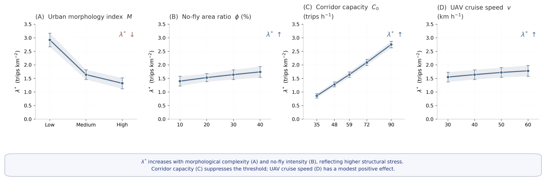
Figure 5.
Sensitivity of critical threshold to urban and operational parameters (analytical values from Equation (7)). (A) Urban morphology index M (via ). (B) No-fly area ratio . (C) Corridor capacity . (D) UAV cruise speed v. Error bars: from formula parametric variation. Dongli reference: dashed line at .
Figure 5.
Sensitivity of critical threshold to urban and operational parameters (analytical values from Equation (7)). (A) Urban morphology index M (via ). (B) No-fly area ratio . (C) Corridor capacity . (D) UAV cruise speed v. Error bars: from formula parametric variation. Dongli reference: dashed line at .
6.7. Cross-District Validation and Morphological Moderation
Table 11 reports the complete -sweep results for Pudong (Shanghai) and Chaoyang (Beijing), replacing the threshold-level snapshot of the earlier draft with five demand levels per city ( replications each).
Two-Phase Structure Is Reproduced in Both Districts
Across all ten district- combinations, m while , confirming the Phase I signature in Pudong and Chaoyang as in Dongli. By Proposition 2 Part (i), this follows analytically from std in all three candidate pools.
Urban Morphology Moderates the Curve
The compressed values in Table 11 reflect a single morphological quantity: the capacity differential of the representative depot pair. Dongli yields trips/h (std ); Pudong and Chaoyang yield and trips/h respectively, consistent with more homogeneous building-height distributions at comparable inter-depot distances. Because enters the numerator directly (Equation (6)), a three- to four-fold reduction compresses the curve proportionally, pushing above the tested demand range. This is a framework prediction, not a limitation: cities with more homogeneous building-height distributions experience a later regime transition, and must be computed from local GIS data before applying Equation (7).
The Leading-Indicator Property of Is City-Invariant
m at in both Pudong and Chaoyang, well before any cost signal. Proposition 2 Part (iii) guarantees this for any and , independent of morphology.
6.8. Planning Implications
Finding 1: Diagnose your city first. depends on local morphology through three GIS-observable parameters (, , d). For Dongli District, (5.5× current density) places the threshold at a 5–10 year horizon. This estimate is grounded in observed UAV logistics expansion in Chinese pilot cities: according to CAAC statistical bulletins, registered UAVs grew by 51% year-over-year in 2025 and cumulative flight hours increased by 69.89% over the same period [3]. Under a conservative 30% annual growth assumption, the 5.5× gap closes in approximately 8 years; under 50% growth, in approximately 5 years. Planners in cities with faster adoption trajectories (e.g., Shenzhen, Hangzhou) should apply their local growth rate to to obtain a city-specific planning horizon.
Finding 2: Monitor structure, not cost. is detectable at , approximately 8× below the cost-positive threshold at .
Finding 3: is a planning trigger, not a cost guarantee. When crosses unity, infrastructure decisions grounded in distance-dominated optimality are structurally misaligned.
Figure 6.
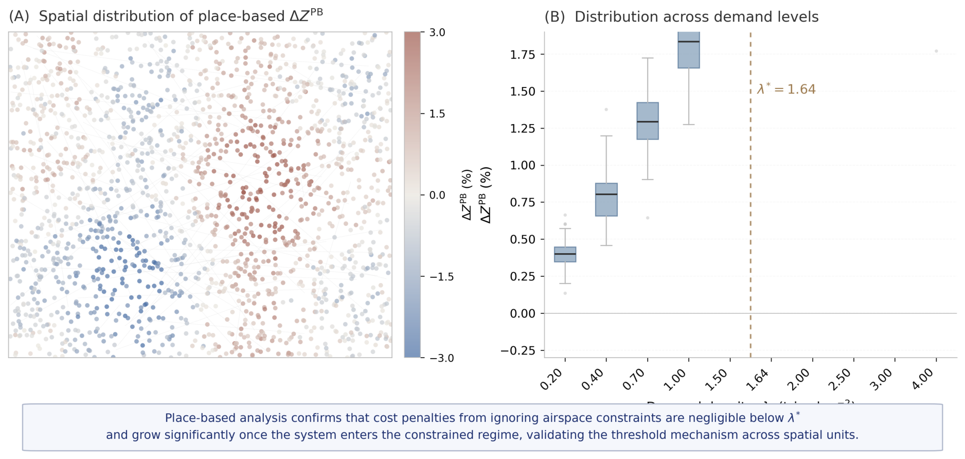
Place-based robustness experiment ( demand-point samples per ). Panel A: Spatial distribution of at ; warm colours indicate cost penalties from distance-only planning. Panel B: across demand levels; boxes shift from near-zero (Phase I, ) to systematically positive (Phase II, ), validating the threshold mechanism across spatial units.
Figure 6.
Place-based robustness experiment ( demand-point samples per ). Panel A: Spatial distribution of at ; warm colours indicate cost penalties from distance-only planning. Panel B: across demand levels; boxes shift from near-zero (Phase I, ) to systematically positive (Phase II, ), validating the threshold mechanism across spatial units.
7. Conclusions
This paper has documented and formalized a system transition not previously identified in the UAV logistics literature: infrastructure configurations begin adapting to airspace capacity constraints at demand levels where cost metrics register no anomaly. Structural change precedes the cost signal by a factor of 8.2× in demand density (): is detectable at while the cost advantage is confirmed only from onward. Cost is a lagging indicator. The framework provides the missing leading indicator.
Four substantive findings follow. First, the two-phase regime transition is analytically grounded, not an empirical coincidence, as established in the complete proof of Proposition 2 (Appendix B) for any . Second, the closed-form index provides a computationally cheap pre-screening tool requiring only three city-level parameters. Third, is a more sensitive leading indicator of regime transition than any cost metric. Fourth, the threshold range is narrow and predictable across morphologically diverse Chinese urban districts (1.61–, a 15% range), consistent with Proposition 1.
Several limitations motivate future work. The model considers a single operator; fixed depots; and FAR-based capacity as a geometric proxy for corridor navigability. The BPR intercept [9] is not empirically varied (; shifts by ). The cross-district validation covers three Chinese districts; extension to Western city morphologies and full -sweeps for Pudong and Chaoyang remain open.
From a policy perspective, provides a quantitative trigger for the six Chinese pilot cities with sub-600 m airspace authority to transition from registration-only depot approval to integrated airspace-logistics assessment, computable from standard GIS inputs and UOM flow records.
Future directions. The most direct extension is multi-operator competition: with N operators, corridor flows become Nash equilibria and may shift due to competitive over-utilisation of high-capacity corridors [16]. Microscopic validation—whether collision-avoidance UAV agents reproduce BPR-consistent macroscopic flows—would further strengthen operational realism.
Funding
This work was supported in part by the National Natural Science Foundation of China under Grant 52202404; in part by the Major Science and Technology Project of Xizang Autonomous Region under Grant XZ202402ZD0004; and in part by the Fundamental Research Funds for the Central Universities under Grant 3122017064.
Data Availability Statement
The building polygon and road network shapefiles for Dongli District, Tianjin used in this study are available from the corresponding author upon reasonable request.
Conflicts of Interest
The authors declare that they have no known competing financial interests or personal relationships that could have appeared to influence the work reported in this paper.
Use of Artificial Intelligence
The authors declare that no generative AI or AI-assisted technologies were used in the preparation of this paper.
Appendix A. Complete Derivation of the Ω Index and Critical Threshold f *
This appendix provides the full algebraic derivation of Equations (6) and (7) from the BPR cost structure introduced in Section 3.
Appendix A.1. Setup
Consider two depot candidates:
- Depot A: distance , corridor capacity
- Depot B: distance , corridor capacity
Setting (units: h/m), the total operating cost of depot i serving demand flow f (trips/h) through its primary corridor is:
where the first term is the distance-proportional flight cost and the second is the BPR-congestion cost.
Appendix A.2. Derivation of Ω(f)
Plan B selects Depot A when . Expanding:
Rearranging (moving distance terms left, congestion terms right):
Expanding the bracket and isolating the term:
where . Adding to both sides and factoring :
Dividing both sides by the right-hand bracket (positive for all ):
This establishes Equation (6). The economic interpretation is immediate: the numerator measures congestion savings from superior corridor capacity ( vs ) over OD distance d; the denominator measures the distance cost of reaching the higher-capacity location () plus the residual congestion at that location.
Appendix A.3. Derivation of f *
Setting and solving for :
Taking the -th root:
which is Equation (7). The denominator is positive if and only if (the existence condition of Corollary 1). When this condition fails, for all finite f and no threshold exists.
Appendix A.4. Monotonicity of Ω(f)
Differentiating with respect to f:
since all parameters are positive and . Hence is strictly increasing in f, crossing unity exactly once at . This confirms that the regime transition is sharp rather than gradual.
Appendix A.5. Dongli District Numerical Values
Substituting the calibrated parameters (Table 5) with h/m, , , and :
Appendix B. Complete Proof of Proposition 2
All notation follows the main text; , p is the unit flight cost, in the numerical instantiation but all proofs hold for any .
Appendix B.1. Lemma and Part (i): D reloc (λ)>0 for all λ>0
Lemma A1.
For any two candidates with and , Plan B strictly prefers i over j for any , while Plan A is indifferent.
Proof. since ; Plan A evaluates both at , yielding zero difference. □
Proof of Part (i). The capacity heterogeneity condition (std , confirmed for Dongli, Pudong, and Chaoyang with values 3.40, 2.18, and 4.42 trips/h respectively) guarantees at least one pair with . By Lemma B.1, Plans A and B assign different optimality weights to such a pair for any , producing different optimal depot sets and therefore . □
Appendix B.2. Part (ii): ΔZ(λ) strictly increasing
Let and denote the distance and capacity of the depots selected by Plans A and B respectively, with under Lemma B.1. Then:
For Dongli: , , so and for all .
General equivalence. iff . Substituting , and and rearranging yields exactly the Corollary 1 existence condition , confirming that Parts (i)–(ii) share the same structural precondition. □
Appendix B.3. Part (iii): Phase I non-degeneracy
Asymptotic decomposition. From the BPR cost structure:
where both terms are negative (Plan B pays a distance premium but saves more on congestion). The cost advantage ratio is:
As , the congestion-saving term in the numerator vanishes while the denominator is dominated by the fixed cost , giving the closed-form limit:
Finite-width Phase I. For any , there exists such that for all . Empirically, for (Section 6). Combining with Part (i), the interval constitutes a genuine Phase I: throughout while . The limit (B.4) is consistent with the observed at (Table 9): the gap between 0.02% and 0.41% reflects stochastic noise over replications and the non-zero term at finite . The non-degeneracy holds for any and positive cost parameters; it is a structural consequence of the vs. scaling contrast between BPR congestion savings and fixed infrastructure costs. □
References
- Arnott, R.; de Palma, A.; Lindsey, R. A structural model of peak-period congestion. Am. Econ. Rev. 1993, 83(1), 161–179. [Google Scholar]
- Chung, S. H.; Siddiqui, A. W.; Ma, H. L. Heterogeneous drone delivery with battery constraints. Transp. Res. Part B 2020, 136, 68–89. [Google Scholar]
- Civil Aviation Administration of China. 2025 statistical bulletin on civil aviation development. Technical report; Civil Aviation Administration of China (CAAC): Beijing, China, 2025. [Google Scholar]
- Cummings, C.; Mahmassani, H. Airspace congestion, flow relations, and 4-D fundamental diagrams for advanced urban air mobility. Transp. Res. Part C 2024, 159, 104467. [Google Scholar] [CrossRef]
- Daganzo, C. F. The cell transmission model. Transp. Res. Part B 1994, 28(4), 269–287. [Google Scholar] [CrossRef]
- Dorling, K.; Heinrichs, J.; Messier, G. G.; Magierowski, S. Vehicle routing problems for drone delivery. IEEE Trans. Syst. Man. Cybern. 2017, 47(1), 70–85. [Google Scholar] [CrossRef]
- Kitjacharoenchai, P. Multiple traveling salesman problem with drones. Transp. Res. Part C 2019, 102, 204–225. [Google Scholar]
- Kopardekar, P. Unmanned aircraft system traffic management (UTM) concept of operations. AIAA Aviation Forum, 2016; AIAA. [Google Scholar]
- Levin, M. W.; Stuive, L.; Gzara, F. Airspace network design for urban UAV traffic management with congestion. Transp. Res. Part C 2024, 168, 104830. [Google Scholar]
- Macrina, G. Drone-aided routing: A literature review. Transp. Res. Part C 2020, 120, 102762. [Google Scholar] [CrossRef]
- Mercan, Tülin; Yavaş, Volkan; Can, Dilek; Mercan, Yasin. Vertiport location selection criteria for urban air mobility. J. Air Transp. Manag. 2025, 124, 102700. [Google Scholar] [CrossRef]
- Murray, C. C.; Chu, A. G. The flying sidekick traveling salesman problem. Transp. Res. Part C 2015, 54, 86–109. [Google Scholar] [CrossRef]
- Otto, A. Optimization approaches for civil applications of UAVs. Networks 2018, 72(4), 411–458. [Google Scholar] [CrossRef]
- Revillod, G.; Kremer, J.; Bierlaire, M. Vertiport location and sizing: A methodology for airport operators. Transp. Res. Part E Logist. Transp. Rev. 2025, 194, 103912. [Google Scholar]
- Rimjha, M. New infrastructures for urban air mobility systems. J. Air Transp. Manag. 2023, 111, 102437. [Google Scholar]
- Roughgarden, T. Selfish Routing and the Price of Anarchy; MIT Press: Cambridge, MA, 2005. [Google Scholar]
- Stolaroff, J. K. Energy use and life cycle greenhouse gas emissions of drones for commercial package delivery. Nat. Commun. 2018, 9, 409. [Google Scholar] [CrossRef]
- Vickrey, W. S. Congestion theory and transport investment. Am. Econ. Rev. 1969, 59(2), 251–260. [Google Scholar]
- Weng, C. Urban low-altitude air transport management. Transp. Res. Part C 2025, 178, 105237. [Google Scholar] [CrossRef]
Figure 1.
Regime-transition mechanism in UAV logistics infrastructure planning. Four panels trace the progression from unconstrained distance-optimal siting (Panel A) through structural adaptation (Panel B) and regime transition at (Panel C) to congestion-dominated reconfiguration (Panel D). Cost monitoring signals a problem only in Panel D; the infrastructure transition is already underway in Panels B–C.
Figure 1.
Regime-transition mechanism in UAV logistics infrastructure planning. Four panels trace the progression from unconstrained distance-optimal siting (Panel A) through structural adaptation (Panel B) and regime transition at (Panel C) to congestion-dominated reconfiguration (Panel D). Cost monitoring signals a problem only in Panel D; the infrastructure transition is already underway in Panels B–C.
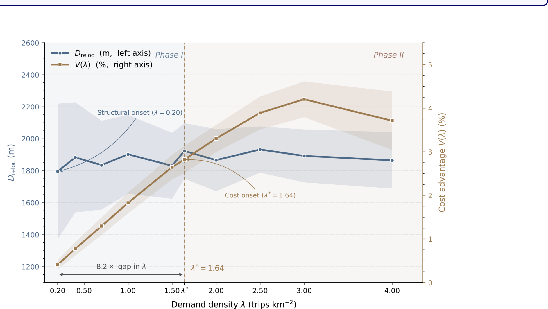
Table 1.
Marginal Contribution Relative to Existing Paradigms.
| Dimension | Existing LRP | Existing | This Paper |
|---|---|---|---|
| Depot location | Optimized | Fixed (exogenous) | Optimized |
| Airspace capacity | Ignored | Modeled | Endogenous + threshold |
| Decision criterion | None | None | index (closed-form) |
| Phase transition | None | None | Two-phase mechanism |
| Early-warning indicator | None | None | (leading) |
| Cost vs. structure | None | None | Lead–lag relationship formalized |
Note: LRP = Location-Routing Problem; UTM = Urban Traffic Management (airspace); ★UTM column covers existing airspace management models in which depot/vertiport locations are treated as fixed exogenous inputs; = mean depot relocation distance between airspace-aware and distance-only plans; “leading” indicates that detects the structural transition before cost metrics escalate.
Table 2.
Three-Layer Airspace Parameters (Dongli District).
| Layer | Height (m) | Capacity (trips/h) | Speed (km/h) | Factor | Dongli std |
|---|---|---|---|---|---|
| L0 — Low | 0–40 | 60 | 40 | 1.25 | 3.40 |
| L1 — Mid | 40–80 | 100 | 50 | 1.00 | |
| L2 — High | 80–120 | 150 | 60 | 0.83 |
Table 3.
Sensitivity of to FAR Capacity Scaling (±20% perturbation).
| Scenario | Scaling | (trips/h) | (trips/h) | () |
|---|---|---|---|---|
| FAR −20% | 47.2 | 38.4 | 1.37 | |
| FAR Baseline | 59.0 | 48.0 | 1.64 | |
| FAR +20% | 70.8 | 57.6 | 1.90 | |
| Range: 1.37–1. (±16% around baseline). | ||||
| All values remain 4.6–6.3× above current density. | ||||
Table 4.
Two-Phase Regime Transition.
| Phase | Condition | Structural Response | Cost Response |
|---|---|---|---|
| I (Structural) | , | : depots diverge from logistics-optimal | : negligible |
| II (Cost Escal.) | , | : continues | strictly increasing; |
Table 5.
Framework: Parameters and Results (Dongli District).
| Parameter | Value | Interpretation |
|---|---|---|
| OD reference distance d | 3,000 m | GFA-weighted mean road-network distance, building centroids to nearest depot (road shapefile) |
| High-capacity depot | 59.0 trips/h | L0 capacity of the representative high-capacity depot candidate (FAR method; highest-capacity member of the pair within 500–1,500 m with maximum , building shapefile) |
| Low-capacity depot | 48.0 trips/h | L0 capacity of the representative low-capacity depot candidate (FAR method; selected as the candidate within 500–1,500 m of with maximum , building shapefile) |
| Distance penalty | 800 m | Road-network distance between and depot sites (road shapefile) |
| BPR parameters | Standard BPR [9] | |
| Unit flight cost p | 0.008 yuan/m | Operator cost estimate |
| Critical flow | 39.0 trips/h | From Equation (7) |
| Critical density | ||
| Current delivery density | Operator estimates (2025) | |
| Gap to threshold | current density | Distance-based planning sufficient today |
Table 6.
ALNS Algorithm Parameters.
| Parameter | Value | Role |
|---|---|---|
| Open depots | 4 | Fixed fleet size |
| Initial temperature | – | SA exploration width |
| Cooling rate | 0.997 | Geometric cooling |
| Iterations n | 1,000 | Computational budget |
| Operator weights (init.) | Uniform start | |
| Reward (best improve) | Adaptive scoring | |
| Reward (improvement) | Adaptive scoring | |
| Random seed | 42 | Reproducibility |
| UAV range | 10 km (one-way) | Feasibility constraint |
Table 7.
Three-Plan Comparison: Phase I (, ). All values are replication means, fully consistent with Table 9.
Table 7.
Three-Plan Comparison: Phase I (, ). All values are replication means, fully consistent with Table 9.
| Metric | Plan A (distance-only) | Plan B (airspace-aware) |
|---|---|---|
| Total Cost (yuan) | 33,961 | 33,340 |
| Flight Cost (yuan) | 1,961 | 1,340 |
| Congestion Cost (yuan) | 0.3 | 0.0 |
| Avg L0 Capacity (trips/h) | 56.7 | 58.3 ★ |
| Depots Relocated | 0/4 | 3/4 ★ |
| (m) | — | 1,902 ★ |
| Assignment Change Ratio | — | 99.6% ★ |
| — | ★ | |
| ★ Structural divergence is already substantial at : m and 99.6% of customers are reassigned under Plan B, yet is modest relative to the structural reorganization magnitude. This decoupling—large structural shift, moderate cost signal—is the defining feature of Phase I and confirms that cost monitoring alone fails to detect the approaching regime boundary. confirms Phase I status. | ||
Table 11.
Cross-District -Sweep: Two-Phase Structure and Parameters ( per ; ; m; seed = 42). computed from Equation (6) using each district’s representative depot pair (500–1,500 m range, maximum ).
Table 11.
Cross-District -Sweep: Two-Phase Structure and Parameters ( per ; ; m; seed = 42). computed from Equation (6) using each district’s representative depot pair (500–1,500 m range, maximum ).
| District | (m) | (%) | n | Phase | |||
|---|---|---|---|---|---|---|---|
| Pudong (Shanghai): , , tr/h, m, m, L0 std tr/h | |||||||
| 0.50 | 0.000 | 1,579.8 | +0.544 | 0.237 | 20 | I | |
| 1.00 | 0.005 | 1,483.8 | +1.057 | 0.546 | 20 | I | |
| 1.50 | 0.030 | 1,474.5 | +1.527 | 0.863 | 20 | I | |
| 2.00 | 0.086 | 1,413.9 | +1.663 | 1.081 | 20 | I | |
| 3.00 | 0.171 | 1,315.2 | +3.004 | 1.510 | 20 | ||
| Chaoyang (Beijing): , , tr/h, m, m, L0 std tr/h | |||||||
| 0.50 | 0.000 | 1,593.4 | +0.805 | 0.292 | 20 | I | |
| 1.00 | 0.008 | 1,788.4 | +1.402 | 0.381 | 20 | I | |
| 1.50 | 0.053 | 1,702.9 | +1.945 | 0.477 | 20 | I | |
| 2.00 | 0.133 | 1,807.0 | +2.359 | 0.460 | 20 | I | |
| 3.00 | 0.228 | 1,820.4 | +2.873 | 0.421 | 20 | ||
| † Both districts remain in Phase I throughout the tested range; the analytical lies above 3. for both (see morphological discussion below). The representative pair is selected as the candidate pair within 500–1,500 m with the largest , consistent with the Dongli calibration procedure. | |||||||
Disclaimer/Publisher’s Note: The statements, opinions and data contained in all publications are solely those of the individual author(s) and contributor(s) and not of MDPI and/or the editor(s). MDPI and/or the editor(s) disclaim responsibility for any injury to people or property resulting from any ideas, methods, instructions or products referred to in the content. |
© 2026 by the authors. Licensee MDPI, Basel, Switzerland. This article is an open access article distributed under the terms and conditions of the Creative Commons Attribution (CC BY) license (http://creativecommons.org/licenses/by/4.0/).
Copyright: This open access article is published under a Creative Commons CC BY 4.0 license, which permit the free download, distribution, and reuse, provided that the author and preprint are cited in any reuse.