Submitted:
16 April 2026
Posted:
17 April 2026
You are already at the latest version
Abstract
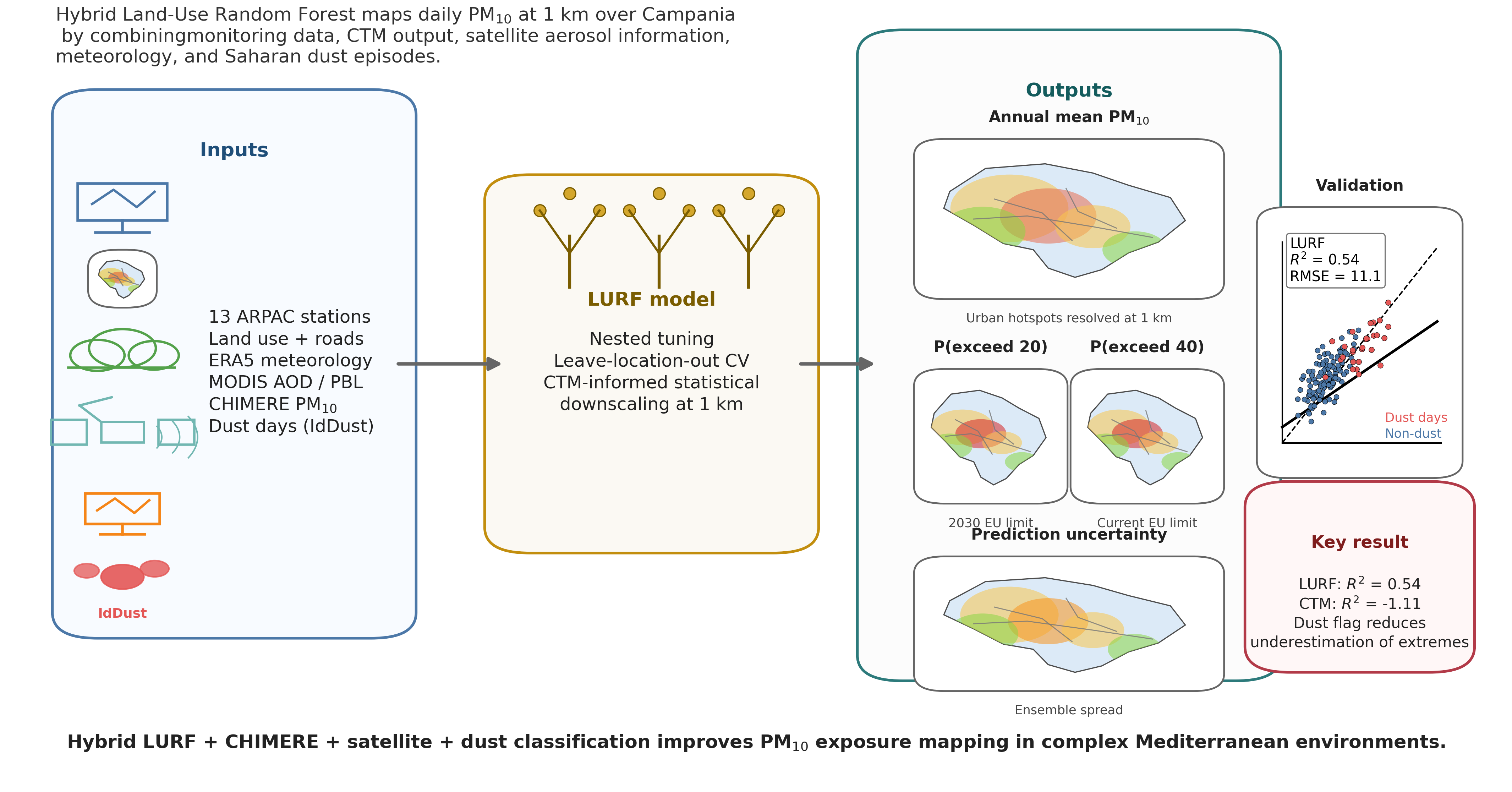
In this study we develop a Land-Use Random Forest (LURF) model for the Campania Region (southern Italy) that combines 2022 daily PM10 observations from 13 quality-controlled ARPA Campania stations with a rich set of spatial predictors to produce daily concentration maps at 1000 m × 1000 m resolution, from which annual statistics (mean, percentiles, and exceedances) are derived through temporal aggregation. The predictor space includes resident population, land-cover and imperviousness indicators, road-network metrics derived from OpenStreetMap, meteorological fields from the ERA5 reanalysis, satellite aerosol optical depth (AOD) from MODIS Terra and Aqua—scaled by ERA5 boundary-layer height (AOD/pbl)—daily mean PM10 from a nested CHIMERE simulation, and a binary categorical predictor (IdDust) flagging days affected by Saharan dust transport events. The hyperparameters for the LURF model are selected via a nested inner grid search; generalisation performance is assessed through a spatially aware leave-location-out cross-validation (LLO-CV) scheme, which prevents optimistic bias arising from spatial autocorrelation among neighbouring stations. Under LLO-CV, the LURF achieves R2=0.54, RMSE =11.1 μg m−3, and MAE =8.0 μg m−3, against R2=−1.11, RMSE =23.6 μg m−3, and MAE =19.1 μg m−3 for the raw CHIMERE output evaluated on the same observations. The inclusion of IdDust as a categorical covariate allows the Random Forest to partition the training distribution between dusty and non-dusty regimes, improving the representation of episodic high-PM10 events and reducing systematic underestimation at the upper tail of the concentration distribution. CTM-derived PM10 and ERA5 boundary-layer and pressure fields emerge as the dominant predictors, collectively accounting for the majority of explained variability, while IdDust ranks among the physically interpretable secondary predictors. The 1000 m maps highlight marked urban–rural contrasts, resolving hotspots in the Naples metropolitan area and along major motorway corridors that remain unresolved at typical CTM grid spacings. By embedding physically based CTM output, satellite aerosol diagnostics, and dust-event classification within a flexible machine-learning framework, the proposed approach offers a low-cost, operationally tractable tool for high-resolution PM10 exposure assessment in regions characterised by complex terrain and heterogeneous emission sources.
Keywords:
air quality
; PM10
; Land-Use Random Forest
; LURF
; exposure assessment
; campania region
; ERA5
; CHIMERE
; MODIS AOD
; spatial mapping
; dust transport
Copyright: This open access article is published under a Creative Commons CC BY 4.0 license, which permit the free download, distribution, and reuse, provided that the author and preprint are cited in any reuse.


