Submitted:
10 March 2026
Posted:
11 March 2026
You are already at the latest version
Abstract
Hybrid classification approaches, combining pixel-based and object-based classification models, are increasingly being adopted to overcome the inherent limitations of Very High Resolution (VHR) image analysis. This paper proposes a hybrid classification framework that integrates probabilistic pixel-based classification, object-based aggregation, and rule-based refinement to produce GIS-ready Land Use/Land Cover (LULC) maps specifically designed for urban and regional planning. WorldView-2 imagery is first processed using an AdaBoost classifier to derive pixel-level class memberships; these results are subsequently aggregated at the object level following segmentation. Beyond thematic labeling, a Stability Map is introduced to quantify intra-object classification reliability, enabling the spatial identification of unstable or heterogeneous objects. The novelty lies not only in the integration of pixel and object paradigms but also in the operational utility of this stability map. When combined with rule-based reasoning, it provides a decision-oriented GIS product. The results demonstrate superior classification accuracy and enhanced interpretability compared to standard pixel-based or object-based approaches, highlighting the framework's relevance for geospatial data analysis and planning-oriented applications.
Keywords:
WorldView-2
; hybrid classification
; rule-based
; stability map
; LULC
; territorial planning
1. Introduction
Accurate and up-to-date maps of Land Use and Land Cover (LULC) represent a fundamental component of geographic data infrastructures and activities related to land planning, environmental monitoring, and resource management. Within the broader scope of GIScience, such cartographic products serve as an essential informational basis to support complex decision-making processes and to understand the dynamics of land transformation. Classic studies in the field of quantitative geography and GIS have widely highlighted that thematic information derived from geospatial data constitutes an essential component of Spatial Data Infrastructures (SDI), as it allows for the integration and analysis of information from heterogeneous sources [1,2]. In this context, satellite remote sensing has taken on a central role in the systematic production of large-scale thematic mapping.
In the past two decades, the increasing availability of very high spatial resolution satellite imagery (VHR) has significantly expanded the potential level of thematic and spatial detail of LULC maps. Ever more powerful satellite sensors now allow for the observation of landscapes with previously unimaginable levels of detail, enabling the discrimination of urban, infrastructural, and environmental elements with great precision. Various studies have demonstrated how such data can significantly improve the thematic characterization of land use and cover classes, especially in complex urban contexts and areas with high spatial heterogeneity [3,4]. Concurrently, the evolution of image classification techniques has led to the development of increasingly sophisticated methodologies for the analysis of multispectral and multitemporal data.
However, the increase in spatial resolution does not automatically result in improved performance of classification methods. On the contrary, the greater intra-class spectral variability and the presence of complex spatial structures can exacerbate some well-known issues in traditional automatic classification approaches. In particular, pixel-based classifiers, which operate exclusively on spectral information at the single pixel level, tend to produce maps characterized by high thematic fragmentation and the well-known “salt-and-pepper” effect. These limitations have been extensively discussed in the literature on remote sensing and uncertainty analysis in geographic data, highlighting how the complexity of real landscapes often renders traditional methodological applications inadequate [5,6].
In recent years, the development of Machine Learning (ML) and Deep Learning (DL) techniques has significantly improved the performance of pixel-based classification systems for remote sensing images. Despite these advancements, pixel-only classification still faces difficulties in accurately representing spatial structures and contextual relationships present in complex landscapes.
To address these limitations, since the 2000s, the paradigm of Object-Based Image Analysis (OBIA) has gradually emerged, shifting the unit of analysis from individual pixels to spatially coherent objects obtained through image segmentation processes. Several studies have demonstrated that object-oriented analysis can significantly enhance the quality of classifications in the presence of high-resolution images, as it allows for the exploitation of additional information such as shape, size, texture, and topological relationships between objects. Despite the advantages, the performance of OBIA is strongly dependent on the quality of segmentation that can introduce systematic errors that limit the robustness of the approach in complex operational contexts [7].
To overcome such challenges, recent literature has increasingly explored hybrid approaches aimed at combining the strengths of pixel-based and object-based approaches.
Although these advancements, most hybrid solutions primarily focus on improving classification performance or reducing cartographic noise, typically through the aggregation of pixel-based information on segmented objects. However, two fundamental aspects remain relatively underdeveloped in the research. The first concerns the explicit formalization of expert knowledge through rule-based systems, which allow for the integration of contextual knowledge and information from ancillary data in the classification process. The second relates to the availability of spatially explicit reliability indicators, directly interpretable even by non-specialist remote sensing users. In this case, the debate opens on how traditional global accuracy metrics are insufficient to describe the spatial distribution of errors in thematic maps. When cartographic products are used to support decision-making processes, the quality and reliability of geographic information play a central role and are indeed fundamental elements to ensure a conscious use of such geographic information [8].
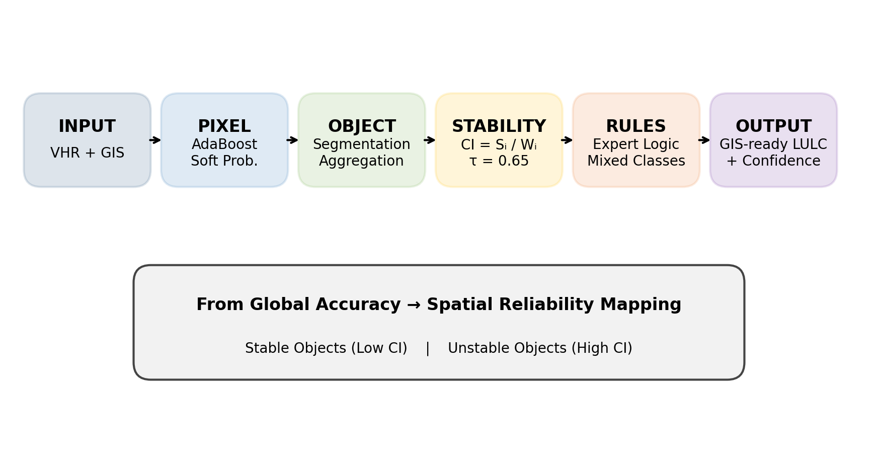
This work fits into this context by proposing a hybrid pixel–object–rules classification framework, designed to bridge these methodological gaps. The approach integrates three main components: a supervised pixel-level classification, an aggregation and analysis process at the object level, and a rule-based decision-making system that explicitly formalizes expert knowledge in the classification process. This methodological framework allows for the generation of consistent, interpretable LULC maps that can be directly used in large-scale land planning contexts [9].
The most scientifically novel element of the proposed framework lies not only in the combination of pixel-based and object-based aproaches but especially in the introduction of a Stability Map. This cartographic product quantifies the stability and reliability of classification at the object level, explicitly maintaining the spatial distribution of uncertainty. Unlike traditional accuracy indicators, generally expressed as synthetic global metrics, the Stability Map is designed as an operational tool to support decision-making processes, facilitate selective validation activities, and improve transparency in the use of territorial data [10,11]. In this context, the stability of classification is not simply interpreted as a diagnostic measure of model performance but as explicit spatial information, designed to be integrated into land planning and management workflows, as an additional informational layer to enhance transparency in the use of cartographic products.
The article is organized as follows. After this introduction, the Related Works section presents a review of the state of the art on pixel-based, object-based, and hybrid classification methods, with particular attention to the integration of expert knowledge and the representation of uncertainty. The Materials and Methods describe dataset, study area, and proposed methodology, including the formulation of the Stability Map. The Results section presents the obtained results and the comparison with traditional approaches. The Discussion section analyzes the methodological and operational implications of the proposed framework, and finally, the Conclusions section summarizes the main contributions of the research and discusses possible future developments.
2. Related Works
Automated classification to produce LULC maps has been a central theme in Earth Observation (EO) research and GIScience for several decades [12]. Over time, numerous methodological approaches have been developed, differing mainly in the type of analysis adopted and the information used in the classification process.
One historically established family of methods is represented by pixel-based classifiers, which use only the spectral information associated with each pixel of the image. Due to their conceptual simplicity and solid theoretical background, these pixel-based classifiers serve as a natural foundation for thematic mapping. A systematic review of the main methods for classifying remote sensing images has been provided in the literature [13]. However, when applied to VHR images, these methods are heavily affected by increased spectral variability and landscape fragmentation.
Recently, the development of ML and DL techniques has significantly improved the performance of these models by introducing non-parametric algorithms, such as Support Vector Machines, Random Forests, and deep neural networks. These have demonstrated a remarkable ability to handle high-dimensional datasets and classes characterized by complex spectral signatures, without requiring assumptions about data distribution [14,15,16]. DL techniques have rapidly spread in the field of remote sensing due to their effectiveness in numerous classification and semantic segmentation applications, allowing them to overcome some limitations of traditional approaches by capturing multiscale information in high-resolution satellite images [17,18,19,20]. Despite these advancements, even these advanced approaches can struggle to adequately represent the spatial and semantic structure of territorial elements when operating exclusively at the pixel level.
OBIA approach has progressively emerged in response to these limitations, considering spatially coherent objects derived from image segmentation processes as the unit of analysis, rather than individual pixels. This approach facilitates the integration of spectral characteristics with geometric, textural, and contextual information, improving the semantic coherence of the results and making the maps more compatible with the data models used in GIS systems [21,22,23]. By emphasizing scale, semantics, and spatial context as key components of the interpretation of remote sensing images, OBIA appears to be a suitable solution for LULC mapping in GIS [24,25,26,27]. Several studies have demonstrated the effectiveness of OBIA in classifying high-resolution images. The comparison between pixel-based and object-based classifications, on images with different spatial resolutions, highlighting how object-oriented approaches can provide more accurate results when applied to high-resolution data [28]. Similarly, other researchers showed how the integration of ancillary data can further improve object-based classification by reducing confusion among spectrally similar classes in urban areas [29]. However, OBIA approaches also present some challenges. In particular, the performance of classification systems is heavily dependent on the quality of the initial segmentation and the choice of scale parameters, which can significantly affect the definition of objects and subsequent classification, especially in heterogeneous urban and peri-urban environments.
To leverage the complementary strengths of pixel-based and object-based paradigms, hybrid classification approaches have been increasingly studied [30,31]. Several studies have shown that integrating pixel-level spectral information with spatial structures derived from segmentation can enhance both thematic accuracy and spatial consistency of cartographic products [32]. Early object-oriented and hybrid solutions have demonstrated the potential of integrating spectral, spatial, and semantic information to provide GIS-ready products [33,34]. One of the first contributions in this direction is represented by a work that developed a fuzzy approach capable of combining pixel-based and object-based classifications to enhance urban class discrimination in high-resolution images [35]. Subsequently, other studies have shown how the integration of information from different levels of analysis can improve both thematic accuracy and spatial coherence of the produced maps [36,37,38].
In this context, subsequent studies have confirmed that hybrid approaches can outperform strictly pixel-based or object-based methods, especially in complex landscapes, for LULC mapping from VHR images, demonstrating the potential of integrating pixel-level classification and object-level analysis [39,40]. However, most hybrid frameworks remain primarily focused on accuracy and are often designed to provide a single thematic map, with limited attention paid to the internal heterogeneity of the object or the explicit representation of classification reliability.
Although relatively unexplored, this additional strand of research looks at the integration of expert knowledge into classification workflows through rule-based systems, particularly effective for products to be used in GIS environments. In the context of object-based classification, rules allow for the incorporation of semantic constraints, spatial relationships, and contextual knowledge into the classification process, thereby improving the interpretability and adaptability of the results [41]. Nevertheless, in many operational workflows, such rules remain implicit or are used only as post-processing heuristics rather than as integral elements of the classification strategy. In some cases, the use of a decision trees demonstrated how it can automatically derive interpretable rule sets within the context of object-based land cover classification [42]. Another open question concerns the representation of uncertainty in classification results. Traditionally, the quality of thematic maps is assessed through synthetic indicators such as Overall Accuracy and Kappa coefficient. However, several authors have highlighted how such global metrics are insufficient to describe the spatial distribution of error and uncertainty in classified products [43,44,45], and more recent analyses emphasize the need to use more articulated and contextual indicators to correctly interpret the results [46].
In this context, there is an increasing need to develop spatially explicit reliability indicators capable of representing not only overall accuracy but also the local stability of the classification. Such information is particularly relevant in applications oriented towards land planning, where understanding the uncertainty associated with the data is essential to support informed decisions and to ensure that the results can be directly interpreted by end-users within GIS environments and SDI.
3. Materials and Methods
3.1. Dataset and Study Area
The methodology was tested using WV2 multispectral imagery, characterized by very high spatial resolution (2 m) and eight spectral bands with 16-bit radiometric resolution, which enhance the discrimination of land cover classes.
The study area corresponds to the Municipality of Pesaro (Marche Region, central Italy), a representative medium-sized Mediterranean city (approximately 13,000 ha). The landscape is characterized by dense urban fabric, industrial zones, complex agricultural mosaics, wooded hills, and coastal environments.
GIS-based technical cartography provided by the local administration, including transport networks, hydrographic features, and urban boundaries, was integrated into the workflow and spatially aligned with the WV2 imagery. These ancillary layers, hereafter referred to as masking, were applied as spatial constraints to selectively exclude predefined landscape elements. This approach optimized both the segmentation and classification processes, enabling the automatic delineation and refinement of specific object classes. This strategy allows for a direct assessment of how masking impacts classification quality and overall accuracy (Figure 1).
The study area represents a challenging test site for a large-scale (1:5000) automatic LULC mapping, due to its high spatial heterogeneity and sharp land-use gradients, where both thematic accuracy and spatial consistency are required. Consequently, the case study is not presented as an isolated application, but rather as a representative scenario for many European municipalities facing similar territorial mapping needs.
3.2. Methodology
The proposed methodology is structured as a coherent, end-to-end workflow that integrates image pre-processing, pixel-based classification, object-based spatial modeling, rule-based refinement and finally the assessment (Figure 2).
Attention is devoted to the pre-processing step, which is essential to ensure spectral consistency, geometric reliability, and computational efficiency when operating on VHR satellite imagery.
The hybrid workflow is not conceived as a simple sequential chain of technical operations, but as a structured integration strategy aimed at reconciling spectral discrimination, spatial abstraction, and thematic interpretability. It was implemented in a modular architecture using the C++ programming language.
In this perspective, pixel-based classification preserves sensitivity to spectral variability, while object-based structures provide spatial coherence and semantic aggregation required for large-scale mapping standards.
3.2.1. Image Pre-Processing
WV2 multispectral bands were subjected to a series of standard yet essential pre-processing steps to preserve the physical significance of spectral information and optimize the imagery for subsequent analysis. Georeferencing ensured the correct spatial alignment of the imagery with existing cartographic data and the GIS layers used for validation and interpretation, within the National Reference System (Gauss-Boaga, Rome40). The multispectral image was co-registered to the study area’s spatial reference framework, minimizing residual misalignments that could have propagated errors during segmentation and object-based analysis.
To manage the high spatial resolution and data volume of WV2 imagery, an image pyramid representation was generated. The pyramidal approach significantly reduces computational costs during segmentation while preserving spatial patterns and spectral characteristics relevant to land cover discrimination.
Spectral and textural features were then derived to enhance class separability [47,48]. The Normalized Difference Vegetation Index (NDVI) was calculated and integrated, as an additional layer, to support the discrimination of vegetated and non-vegetated surfaces. To improve the differentiation of spectrally similar urban materials, Haralick texture features (Entropy, Contrast, Homogeneity) were extracted from Gray-Level Co-occurrence Matrices (GLCM), which quantifies spatial relationships between adjacent pixels [49]. These features are particularly relevant for distinguishing built-up areas, impervious surfaces, and mixed urban fabrics where spectral responses alone are often insufficient.
Complementary texture information was obtained using Gabor filters, which provide multi-scale and multi-orientation representations of spatial frequency content, particularly suitable for urban and agricultural pattern detection [50]. Gabor-based features are highly effective in detecting repetitive patterns and directional structures, such as those associated with urban morphology, road networks, and agricultural row structures [51].
Band algebra was applied to generate pseudo-bands through algebraic operations between the original spectral bands. Band ratios are particularly effective in reducing illumination effects caused by terrain slope and enhancing spectral contrasts relevant to object definition during segmentation. While various band combinations produce markedly different visual responses, their utility is evaluated primarily based on segmentation performance rather than visual appearance. In this study, experimental tests identified the NIR/Coastal ratio as the most effective for enhancing boundary definition and supporting large-scale image segmentation.
The resulting feature set enriched the spectral–spatial representation of the WV2 imagery and provided a robust input for subsequent analysis in complex and mixed land-use environments (Figure 3).
3.2.2. Pixel Based Classification
The first analytical step of the framework involves a pixel-based supervised classification, designed to fully exploit the spectral and textural richness of WV2 imagery while preserving fine-scale thematic information prior to spatial aggregation. This pixel-level approach is intentionally adopted as the initial stage to maximize thematic detail and generate soft class membership values, which constitute a key input for subsequent object-based aggregation and rule-based refinement.
Classification was performed using the AdaBoost (Adaptive Boosting) algorithm within a supervised learning context. AdaBoost is an ensemble learning technique that iteratively combines multiple weak classifiers into a single strong classifier by adaptively re-weighting training samples based on their classification difficulty [52]. In each iteration, higher weights are assigned to misclassified pixels, forcing the algorithm to focus progressively on spectrally ambiguous or heterogeneous areas. This iterative mechanism makes AdaBoost particularly suitable for VHR imagery, where class boundaries are complex and intra-class variability is high.
Training and control samples were manually selected for each land cover class using representative areas distributed across the study area. These datasets were explicitly associated with the CORINE Land Cover (CLC) nomenclature at the third hierarchical level, including artificial surfaces, agricultural areas, forest and semi-natural environments, and water bodies. This choice ensures a standardized and transferable thematic structure, while maintaining semantic consistency across pixel-based classification, object-level aggregation, and stability assessment.
Sample selection represents one of the most critical phases of the classification process, as the quality and spatial correctness of training and control samples directly influence classification performance. To reduce bias and improve generalization, samples were selected to ensure spectral representativeness, spatial diversity, and independence between calibration and validation datasets.
The first pixel-based classification, obtained after convergence of the boosting process, produced a detailed thematic map characterized by high local accuracy but affected by the typical salt-and-pepper effect associated with pixel-level approaches applied to VHR imagery (Figure 4).
A second pixel-based classification was implemented following the application of a mask (class 999), derived from urban, road, and river layers provided by the Municipality of Pesaro and superimposed onto the spectral data. As shown in Figure 5, the resulting thematic map is spatially coherent, featuring well-defined class boundaries and a limited ‘salt-and-pepper’, local noise effect, which underscores the positive impact of masking on classification clarity. However, the resulting map still exhibits a systematic overestimation of the Permanent crops class within urban areas, mainly due to spectral similarities between urban vegetation and agricultural surfaces at very high spatial resolution. Such a limitation highlights the intrinsic weakness of strictly pixel-based approaches in semantically complex environments.
The AdaBoost classifier, that achieved robust performance, with an Overall Accuracy of 90% and a Kappa coefficient of 0.88, in the no masking case, was improved with an Overall Accuracy of 91% and a Kappa coefficient of 0.895, with masking refined. In any case these results confirm the suitability of AdaBoost as a reliable baseline for VHR multispectral classification.
Nevertheless, the pixel-based outputs were not treated as final products. Despite their high thematic detail, they remain affected by local noise and semantic ambiguity in heterogeneous environments. For this reason, pixel-based classification is embedded within a hybrid framework, where soft class memberships, by AdaBoost, are aggregated at the object level and subsequently refined through explicit rule-based reasoning. This strategy enables classification uncertainty to be propagated and spatially operationalized through the stability map, providing a direct link between pixel-level discrimination and object-level reliability assessment.
3.2.3. Image Segmentation
Image segmentation represents a pivotal stage in the proposed hybrid framework, as it defines the spatial units through which pixel-level information is aggregated and transformed into GIS objects. In this study, segmentation is conceived not merely as a pre-processing step, but as a structural component that bridges the gap between fine-scale spectral information and semantically meaningful landscape entities relevant for territorial planning.
Segmentation quality directly affects both object geometry and the effectiveness of subsequent object-based classification. Variations in input imagery, texture features, and segmentation parameters result in fluctuating object counts and boundary precision. Accordingly, segmentation quality must be defined in relation to the intended application, input data characteristics, and thematic requirements of large-scale LULC mapping, in line with established OBIA principles [33].
The image segmentation algorithm, employed in this study, integrates edge-detection and region-growing strategies, combining boundary-sensitive information with region homogeneity criteria. Region growing aggregates spatially adjacent pixels based on spectral similarity criteria, while edge-detection identifies radiometric discontinuities that constrain region expansion and improve boundary localization. The underlying hypothesis is that significant objects within multispectral imagery are characterized by closed boundaries, which play a dominant role in object perception and recognition.
Segmentation was performed on the pyramidal Coastal band of WV2 imagery, selected for its sensitivity to fine spatial discontinuities and its ability to enhance object boundaries in heterogeneous landscapes. The use of an image pyramid approach facilitated segmentation at an appropriate spatial scale, reducing computational complexity while preserving dominant spatial patterns and structural landscape features. Segmentation was provided both with no masking and with masking, enabling a direct evaluation of the effect of ancillary spatial constraints on object geometry and homogeneity (Figure 6).
Segmentation parameters were configured to generate geometrically regular and cartographically meaningful objects, assigning higher weights to compactness, solidity, and convexity, and lower weights to roundness and shape factors. Parameters with marginal impact on segmentation quality were held constant based on established literature and preliminary testing. The analysis focused on optimizing key variables: input imagery, spectral difference threshold, theta coefficient, and minimum mapping unit (MMU). These parameters were calibrated through an iterative process to strike a balance between over-segmentation (resulting in fragments lacking semantic meaning) and under-segmentation, which risks merging distinct land cover types, such as urban fabric, agricultural parcels, and natural areas, into single objects.
To further reduce over-segmentation, a region redistribution phase based on spatial adjacency and spectral similarity was applied. This strategy, inspired by Yu and Wang [53], was adapted in this study to improve robustness and flexibility when processing heterogeneous VHR imagery.
Although a perfect correspondence between image objects and real-world geographic features cannot be assumed, the adopted segmentation strategy produces spatial units that are sufficiently coherent to support object-based classification, rule-based reasoning, and planning-oriented spatial analysis, in a GIS environment [25].
3.2.4. OBIA Classification
Following image segmentation, pixel-level classification outputs were aggregated at the object level to transform detailed but noisy pixel-based results into spatially coherent and semantically meaningful LULC objects. This aggregation step constitutes an important step of the proposed hybrid framework, as it explicitly bridges probabilistic pixel-based classification with object-based spatial entities compatible with GIS data models and territorial planning requirements.
Object-level representation preserves internal heterogeneity while enabling spatial coherence, allowing the identification of mixed or transitional features, which are common in fragmented and peri-urban landscapes. Integration is achieved by means structured aggregation strategies, including Winner Takes All (WTA) rules and membership-based attribution. The initial WTA classification is applied to the output derived from the AdaBoost classifier and mapped to segmented objects without masking (Figure 7) [54].
At this stage, object labeling was not based on the assignment of a single dominant class. Instead, for each object, pixel-level membership values were ranked to derive object-level membership distributions. Pixel-based thematic information was aggregated within each segmented object by counting the number of pixels assigned to each class and their respective membership values.
This aggregation allowed the identification of dominant and secondary classes, the computation of area percentages for each class, and the estimation of intra-object heterogeneity. Spatial effects become clearly visible when the same pixel-based classification is referenced to objects derived from masked segmentation (Figure 8). This approach is particularly critical for LULC mapping in complex peri-urban environments characterized by gradual land-use transitions, as it preserves information on mixed land-cover conditions and provides a quantitative basis for both rule-based refinement and stability assessment.
Similar aggregation strategies have proven effective in bridging pixel and object-based paradigms and in supporting GIS integration of classified products. Object-level aggregation was performed in accordance with the third-level CLC nomenclature adopted in this study.
3.2.5. Stability Accuracy Assessment
The accuracy assessment of OBIA classification is based on stability. In this context, stability is interpreted as the degree of thematic dominance within each object and is quantified by a stability (confusion) index. Stability is derived from the internal consistency of pixel-level membership values relative to the assigned class and is expressed as a continuous measure ranging from 0 to 1, used to distinguish between areas of high thematic confidence and zones of intrinsic ambiguity.
Rather than being dismissed as classification errors, low-stability objects are considered as significant indicators of landscape complexity, semantic overlaps, or scale discrepancies. Specifically, instability tends to cluster in heterogeneous urban areas and within large-scale objects encompassing multiple land-use types. Although unstable polygons may represent a significant portion of the total objects count, their spatial distribution and areal extent indicate that instability is fundamentally linked to inherent landscape complexity rather than random classification errors.
The stability of each object is quantified through a stability (confusion) index , defined as:
where represents the membership value of the winning class within object , and corresponds to the membership value of the second most represented class.
Low values of indicate a clearly dominant class within the feature, corresponding to homogeneous and reliable objects, whereas high values of identify mixed objects characterized by competing class memberships, reflecting greater classification uncertainty. Based on the stability index defined in Equation (1), objects were classified as stable or unstable using a threshold value :
The threshold was empirically derived from exploratory analysis and previous experimental evidence. This approach reflects a methodological choice where uncertainty is not suppressed but rather explicitly mapped and managed as a core component of the cartographic product.
While the conventional confusion matrix, derived from pixel-based classification, provides an overall measure of thematic accuracy, it does not identify the spatial distribution of classification uncertainty. The proposed hybrid framework overcomes this limitation by generating an explicit Stability Map, which distinguishes stable and unstable objects based on the confusion index. This map supports interpretation of the final LULC product by highlighting polygons whose classification requires verification before operational use. Moreover, the Stability Map highlights areas of high internal heterogeneity, where multiple classes coexist within the same object, supporting both rule-based refinement and the definition of more complex, semantically coherent LULC classes.
Figure 9 and Figure 10 illustrate the Stability Map obtained with no masking and with masking, respectively, and the corresponding accuracy metrics, expressed as the percentage of unstable versus stable polygonal areas, across the study area, serving as indicators of the thematic reliability of the OBIA classification.
3.2.6. Rule Based Refinement
Rule-based refinement was implemented as a hierarchical set of transparent decision rules operating on object-level membership distributions. This approach follows well-established principles of OBIA and GIS-integrated classification, where rules are employed to formalize domain knowledge and resolve ambiguities that cannot be effectively handled by statistical classifiers alone. Rather than replacing automated classification, the rule-based component complements it by introducing controlled expert intervention where automated evidence is insufficient.
Rules ensure semantic consistency of final class assignments, as each object label can be directly traced back to a specific combination of membership conditions and decision rules, facilitating validation process, sensitivity analysis, and transferability across study areas and planning objectives (Table 1). For instance, objects predominantly characterized by artificial surface classes, but showing residual membership in vegetation categories, were assigned to urban fabric classes only when artificial memberships exceeded predefined thresholds. This approach prevented the misclassification of urban green spaces as built-up areas. However, object heterogeneity was explicitly exploited to identify mixed land-use classes through dedicated rule sets.
The rule-based refinement substantially improves the initial WTA results. In particular, the over-representation of the Permanent Crops class is substantially reduced in both urban and agricultural contexts, while the newly introduced mixed classes enhance overall thematic consistency.
By redistributing class memberships at the object level according to explicit contextual rules, the refinement directly modifies the internal membership structure of each object. This evidence is subsequently quantified by the Stability Map as a spatially explicit indicator of classification reliability and residual ambiguity.
As a final refinement step, GIS features representing built-up areas were employed as spatial masks to constrain OBIA. Specifically, objects spatially intersecting the built-up mask were restricted from being assigned to non-artificial CLC classes, enforcing semantic consistency between remote sensing data and existing geospatial datasets. This GIS-based constraint complements the process, resulting in enhanced thematic reliability and overall accuracy.
Overall, the results confirm that a rigid application of OBIA alone can lead to excessive semantic oversimplification and the loss of thematic detail. The integration of rule-based refinement significantly improves thematic stability. By incorporating contextual information and expert-defined rules, several unstable polygons are reassigned to more semantically coherent classes, particularly in complex urban environments.
As shown in the following Results section, the Stability Map of the final LULC product, highlights a clear reduction in the percentage of unstable polygonal areas after rule-based refinement and masking, demonstrating the effectiveness of controlled expert intervention within the proposed hybrid framework. This approach yields LULC map that is not only thematically accurate, but also semantically consistent. This integration ensures a robust transition from pixel-level classification to GIS-ready thematic products, while preserving the necessary information for subsequent stability assessments. Furthermore, this explicit formalization of expert knowledge enhances the long-term reproducibility and maintainability of the classification framework.
4. Results
The results of the proposed hybrid pixel–object–rule-based approach are presented to evaluate both the performance of the automated EO analysis, and the added value provide by the stability assessment. The following comparison aims to highlight not only the differences in global accuracy metrics but also the significant qualitative and spatial improvements introduced by the method, which make it well-suited for operational use.
Overall, the GIS-ready LULC map is characterized by high thematic coherence, reduces salt-and-pepper noise, and improves spatial consistency compared to purely pixel-based classification (Figure 11). Urban fabrics, agricultural parcels, and natural areas are delineated in closer agreement with real-world landscape entities, reflecting the synergistic effect of object-level aggregation and rule-based semantic constraints. Compared to standard OBIA outputs, the hybrid framework shows an enhanced capability to manage internal object heterogeneity. While OBIA alone improves spatial regularity, it can still suffer from misclassification when segmented objects contain mixed spectral signatures. By maintaining and leveraging pixel-level membership distributions, the hybrid proposed approach mitigates this limitation, enabling rule-based refinement to resolve ambiguous cases in a transparent and reproducible manner.
The spatial distribution of stability values further refines the result interpretation. High stability objects are predominantly associated with spectrally homogeneous and semantically well-defined classes, such as compact urban areas, dense vegetation, and uniform agricultural fields. In contrast, low stability values are consistently observed in fragmented land-use patterns and transitional or mixed land-cover areas. This spatial behavior confirms that the Stability Map captures meaningful information regarding classification reliability rather than random noise (Figure 12).
Beyond representing internal heterogeneity, the Stability Map acts as an operational diagnostic layer, systematically highlighting objects that require expert re-evaluation due to a higher probability of misclassification. This capability supports targeted validation strategies, allowing quality control efforts to focus on critical areas rather than being uniformly applied across the map. Such behavior confirms that stability can be interpreted not only as a measure of internal consistency, but also as a practical indicator for error localization and quality control in planning-oriented classification workflows.
Finally, the integration of the GIS-based technical map masking procedure contributed to a moderate but steady improvement in global accuracy metrics, particularly by reducing semantic misclassifications within inhabited areas and enhancing the separation between homogeneous and heterogeneous objects.
4.1. Quantitative Comparison Between the Approaches
A concise quantitative comparison was conducted to evaluate the performance of different classification strategies presented herein: (i) pixel-based classification no masking, (ii) pixel-based classification with masking, (iii) OBIA classification no masking, (iv) OBIA classification with masking, and (v) the proposed full hybrid framework with rule-based refinement.
Results show a consistent improvement in overall accuracy metrics when transitioning from pixel-based to OBIA and, finally, to the hybrid approach (Table 2).
The proposed hybrid framework achieves the highest overall performance, confirming the added value of combining pixel-level probabilities, object-based aggregation, and explicit rule-based refinement. The stability index complements traditional accuracy metrics by preserving spatial variations in classification reliability. While Overall Accuracy and Kappa summarize classification performance into single values, the Stability Map preserves local variations in reliability. This allows for the identification of regions where classification results are dependable and areas where caution or further validation is required.
This additional layer of information is particularly relevant in planning-oriented applications, where localized uncertainty can significantly impact decision-making. By providing an explicit reliability indicator, it enables the informed use of LULC products in spatial analysis and planning processes.
5. Discussion
The results obtained highlight how the proposed hybrid classification framework constitutes a methodologically robust solution for the analysis of VHR satellite images in complex territorial contexts. The most relevant aspect emerging from the analysis of the results does not exclusively concern the improvement of performance by combining different approaches, but rather the method’s ability to produce additional spatial information on the internal coherence and reliability of the classification, which are directly interpretable in an operational context of geospatial data usage. From this perspective, the discussion focuses on the main methodological contributions emerging from the analysis of the results.
One of the most evident aspects of the results concerns the framework’s ability to complementarily exploit the information available at different scales of analysis. The combination of the two analytical approaches makes it possible to preserve the informational detail of multispectral data without compromising the spatial structure of the LULC map, generating territorial objects that are closer to the real entities of the landscape compared to purely pixel-based classifications.
A second significant contribution concerns the introduction of rule-based refinement in the final process of thematic map production. The results highlight how the rule-based system acts as an interpretation level that integrates statistical information derived from classification with explicit decision criteria, allowing for more flexible management of the internal variability of objects. This approach introduces an element of interpretability and transparency into automatic classification, as final decisions do not depend exclusively on the behavior of an automatic classifier, but can be traced back to formalized and verifiable rules. From a methodological point of view, this aspect represents an important step towards the development of more interpretable classification workflows, in line with the growing need for explainability in geospatial analysis processes.
A central element emerging from the results concerns the role of Stability Map as a classification evaluation tool. Traditionally, the quality of LULC classifications is evaluated through global accuracy metrics that, although they are indispensable for comparing different methods, they do not provide indications on the spatial distribution of uncertainty. The stability index, coming from the distribution of pixel-level memberships within each object, represents a synthetic measure of the semantic compactness of the object with respect to the assigned class, defining in this manner the evaluation of the internal coherence of classified objects.
The analysis of the results shows that stability is not randomly distributed in space but reflects significant territorial patterns. Areas characterized by high stability values generally correspond to spectrally and morphologically homogeneous surfaces, while lower values are concentrated in transition zones or in more complex territorial contexts. This behavior suggests that the Stability Map does not simply represent a technical indicator of classification quality but can be interpreted as a spatial proxy of the territorial complexity observed in the image.
At this point, a relevant aspect concerns the potential operational use of the Stability Map. The possibility of explicitly representing the spatial distribution of classification reliability allows for overcoming the traditional binary approach based on the distinction between correct and incorrect classifications. Instead of merely evaluating the overall performance of the model, the methodology allows for identifying areas characterized by different levels of reliability, providing users with a concrete tool for interpreting classification results.
In applied contexts, this information can be used to:
- support targeted validation activities, concentrating checks in areas of low stability;
- identify territorial zones characterized by high heterogeneity;
- integrate an explicit informational layer on data quality into GIS.
In this sense, Stability Map can be considered as a true metadata quality layer integrated into the geographical product, fully compatible with the logic of SDI, where transparency and traceability of information represent fundamental requirements for supporting territorial decisions [55].
Overall, the results suggest that the main contribution of the work does not solely lie in the improvement of accuracy metrics compared to reference approaches. The added value of the methodology consists rather in defining a workflow that integrates cartographic production and the evaluation of its reliability within the same analytical process.
This approach introduces a methodological perspective in which classification is no longer considered a static result, but as an informational product enriched with explicit indicators of its coherence and stability.
In this perspective, the proposed framework moves beyond conventional LULC classification approaches by embedding the evaluation of spatial reliability directly within the mapping process, enabling classification outputs to function not only as thematic representations of land cover but also as operational tools for managing uncertainty in spatial decision-making. As also highlighted in recent studies, the integration of explicit reliability indicators into remote sensing derived products represents an increasingly relevant research direction for making geospatial information truly usable in applied contexts [56].
6. Conclusions
This paper presented a hybrid classification framework, using VHR imagery, to overcome the limitations of purely pixel or OBIA methods, producing GIS-ready LULC maps with improved thematic coherence and spatial consistency.
A core contribution of this work is the introduction of the Stability Map as a spatially explicit reliability indicator associated with the final classification. Unlike traditional global accuracy metrics, stability is computed at the object level and preserved as an independent information layer. Uncertainty and internal heterogeneity are therefore not treated as residual effects of the classification process, but they are explicitly mapped up and made accessible to end users. This marks a conceptual shift from simple and general accuracy to the confidence mapped, which is particularly useful for applications where local reliability takes precedence over global performance statistics.
From a planning perspective, the proposed framework supports decision-making processes by providing both thematic information and explicit reliability indicators. These enable risk-based analysis, prioritization of field surveys, and adaptive planning strategies. Objects characterized by high stability can be used with confidence for regulatory, analytical, and monitoring purposes; conversely, low-stability areas can be systematically identified as critical zones requiring further inspection, validation, or targeted data acquisition.
This approach aligns with SDI principles emphasizing transparency, usability, and quality awareness in spatial decision support systems.
Beyond this specific case study, the methodology is transferable to other VHR datasets and planning contexts, as it relies on interpretable features, explicit decision rules, and modular processing stages rather than black-box optimization.
Looking ahead, this hybrid classification framework offers significant opportunities for further development. The stability concept could support multi-temporal and change-detection analyses, enabling the assessment of temporal consistency and the reliability of detected changes, as well as the integration of the proposed workflow into automated, scalable SDI services. Incorporating additional data sources, such as LiDAR or SAR, could further enhance class discrimination. Moreover, advancements in machine learning, particularly in AI, could bolster the adaptive components of rule-based systems while preserving their interpretability.
From an institutional perspective, adopting hybrid methodologies could foster standardized, repeatable workflows for land-use mapping at regional and administrative levels. This would facilitate consistent monitoring, reduce production costs, and improve the comparability of spatial data over time.
Author Contributions
Conceptualization, Eva S. Malinverni; methodology, Eva S. Malinverni; software, Eva S. Malinverni; validation, Eva S. Malinverni; formal analysis, Eva S. Malinverni; investigation, Eva S. Malinverni and Marsia Sanità; resources, Eva S. Malinverni and Marsia Sanità; data curation, Eva S. Malinverni and Marsia Sanità; writing—original draft preparation, Eva S. Malinverni and Marsia Sanità; writing—review & editing, Marsia Sanità; visualization, Marsia Sanità; supervision, Eva S. Malinverni; project administration, Eva S. Malinverni; funding acquisition, Eva S. Malinverni. All authors have read and agreed to the published version of the manuscript.
Funding
This research was funded by Municipality of Pesaro (Italy).
Data Availability Statement
The dataset presented in this article is not available because the data were bought by the Municipality of Pesaro for technical purposes and the data is unavailable due to privacy.
Acknowledgments
The authors would like to acknowledge the Municipality of Pesaro for providing the technical cartographic datasets to present and publish the results. Special thanks are extended to Eng. L. Garattoni for her valuable support, technical expertise, and constructive insights throughout the development of the research.
Conflicts of Interest
The authors declare no conflicts of interest.
References
- Burrough, P.A.; McDonnell, R.A. Principles of Geographical Information Systems; Oxford University Press: Oxford, UK, 1998. [Google Scholar]
- Longley, P.A.; Goodchild, M.F.; Maguire, D.J.; Rhind, D.W. Geographic Information Systems and Science, 4th ed.; Wiley: Hoboken, NJ, USA, 2015; ISBN 978-1-119-12845-8. [Google Scholar]
- Kuffer, M.; Barros, J.; Sliuzas, R. The development of a morphological unplanned settlement index using very-high-resolution (VHR) imagery. Computers, Environment and Urban Systems 2014, 48, 138–152. [Google Scholar] [CrossRef]
- Chen, B.; Xu, B.; Gong, P. Mapping essential urban land use categories (EULUC) using geospatial big data: Progress, challenges, and opportunities. Big Earth Data 2021, 5(3), 410–441. [Google Scholar] [CrossRef]
- Foody, G.M.; Atkinson, P.M. Uncertainty in Remote Sensing and GIS; John Wiley & Sons: Hoboken, 2002. [Google Scholar] [CrossRef]
- Herold, M.; Liu, X.; Clarke, K. Spatial Metrics and Image Texture for Mapping Urban Land Use. Photogrammetric Engineering and Remote Sensing 2003, 69, 991–1001. [Google Scholar] [CrossRef]
- Marmanis, D.; Schindler, K.; Wegner, J.; Galliani, S.; Datcu, M.; Stilla, U. Classification With an Edge: Improving Semantic Image Segmentation with Boundary Detection. ISPRS Journal of Photogrammetry and Remote Sensing 2016, 135. [Google Scholar] [CrossRef]
- Devillers, R.; Jeansoulin, R. Fundamentals of Spatial Data Quality; ISTE/Wiley; Wiley-ISTE, 2006; p. 312. ISBN 978-1-905-20956-9. [Google Scholar]
- Malinverni, E. S.; Tassetti, A. N.; Mancini, A.; Zingaretti, P.; Frontoni, E.; Bernardini, A. Hybrid object-based approach for land use/land cover mapping using high spatial resolution imagery. International Journal of Geographical Information Science 2011, 25(6), 1025–1043. [Google Scholar] [CrossRef]
- Belgiu, M.; Drǎguţ, L.; Strobl, J. Quantitative evaluation of variations in rule-based classifications of land cover in urban neighbourhoods using WorldView-2 imagery. ISPRS Journal of Photogrammetry and Remote Sensing 2014, 87, 205–215. [Google Scholar] [CrossRef]
- Hussain, E.; Shan, J. Object-based urban land cover classification using rule inheritance over very high-resolution multisensor and multitemporal data. GIScience & Remote Sensing 2016, 53(2), 164–182. [Google Scholar] [CrossRef]
- Yu, E. Review of Remote Sensing Image Classification: Technology Evolution, Method Innovation and Future Challenges. Applied and Computational Engineering 2025, 177(1), 110–116. [Google Scholar] [CrossRef]
- Lu, D.; Weng, Q. A survey of image classification methods and techniques for improving classification performance. International Journal of Remote Sensing 2007, 28(5), 823–870. [Google Scholar] [CrossRef]
- Maxwell, A.; Warner, E.T.; Fang, A.F. Implementation of Machine-Learning Classification in Remote Sensing: An Applied Review. International Journal of Remote Sensing 2018, 39, 2784–2817. [Google Scholar] [CrossRef]
- Audebert, N.; Le Saux, B.; Lefèvre, S. Beyond RGB: Very high resolution urban remote sensing with multimodal deep networks. ISPRS Journal of Photogrammetry and Remote Sensing 2018, 140, 20–32. [Google Scholar] [CrossRef]
- Ma, L.; Liu, Y.; Zhang, X.; Ye, Y.; Yin, G.; Johnson, B. Deep learning in remote sensing applications: A meta-analysis. ISPRS Journal of Photogrammetry and Remote Sensing 2019, 152, 166–177. [Google Scholar] [CrossRef]
- Zhang, L.; Zhang, L.; Du, B. Deep Learning for Remote Sensing Data: A Technical Tutorial on the State of the Art. IEEE Geoscience and Remote Sensing Magazine 2016, 4(2), 22–40. [Google Scholar] [CrossRef]
- Zhao, W.; Du, S. Learning multiscale and deep representations for classifying remotely sensed imagery. ISPRS Journal of Photogrammetry and Remote Sensing 2016, 113, 155–165. [Google Scholar] [CrossRef]
- Zhang, C.; Sargent, I.; Pan, X.; Gardiner, A.; Hare, J.; Atkinson, P. Joint deep learning for land cover and land use classification. Remote Sensing of Environment 2019, 221, 173–187. [Google Scholar] [CrossRef]
- Ma, L.; Yan, Z.; Li, M.; Liu, T.; Tan, L.; Wang, X.; He, W.; Wang, R.; He, G.; Lu, H.; Blaschke, T. Deep Learning Meets Object-Based Image Analysis: Tasks, challenges, strategies, and perspectives. IEEE Geoscience and Remote Sensing Magazine 2024, 2–30. [Google Scholar] [CrossRef]
- Myint, S.; Gober, W.; Brazel, P.; Grossman-Clarke, A.; Weng, S.O. Per-pixel vs. object-based classification of urban land cover extraction using high spatial resolution imagery. Remote Sensing of Environment 2011, 115(5), 1145–1161. [Google Scholar] [CrossRef]
- Georganos, S.; Grippa, T.; Vanhuysse, S.; Lennert, M.; Shimoni, M.; Wolff, E. Very High Resolution Object-Based Land Use-Land Cover Urban Classification Using Extreme Gradient Boosting. IEEE Geoscience and Remote Sensing Letters 2018, 1–5. [Google Scholar] [CrossRef]
- Ez-zahouani, B.; Teodoro, A.; El Kharki, O.; Jianhua, L.; Kotaridis, I.; Yuan, X.; Ma, L. Remote sensing imagery segmentation in object-based analysis: A review of methods, optimization, and quality evaluation over the past 20 years. Remote Sensing Applications: Society and Environment 2023, 32. [Google Scholar] [CrossRef]
- Hay, G.J.; Castilla, G. Geographic Object-Based Image Analysis (GEOBIA): A new name for a new discipline. In Object-Based Image Analysis; Blaschke, T., Lang, S., Hay, G.J., Eds.; Lecture Notes in Geoinformation and Cartography; Springer: Berlin, Heidelberg, 2008; pp. 75–89. [Google Scholar] [CrossRef]
- Blaschke, T. Object based image analysis for remote sensing. ISPRS Journal of Photogrammetry and Remote Sensing 2010, 65, 2–16. [Google Scholar] [CrossRef]
- Blaschke, T.; Hay, G.J.; Kelly, M.; Lang, S.; Hofmann, P.; Addink, E.; Feitosa, R.Q.; van der Meer, F.; van der Werff, H.; van Coillie, F.; Tiede, D. Geographic object-based image analysis – Towards a new paradigm. ISPRS Journal of Photogrammetry and Remote Sensing 2014, 87, 180–191. [Google Scholar] [CrossRef] [PubMed]
- Lang, S.; Hay, G.; Baraldi, A.; Tiede, D.; Blaschke, T. GEOBIA Achievements and Spatial Opportunities in the Era of Big Earth Observation Data. ISPRS International Journal of Geo-Information 2019, 8(11), 1–19. [Google Scholar] [CrossRef]
- Gao, Y.; Mas, J.F. A Comparison of the Performance of Pixel Based and Object Based Classifications over images with various Spatial Resolution. On Line Journal of Earth Science 2008, 2, 27–35. [Google Scholar]
- Sims, F.M.; Mesev, V. Use of Ancillary Data in Object Based Classification of High Resolution Satellite Data. Urban Remote Sensing Joint Event 2007, 1–10. [Google Scholar] [CrossRef]
- Ozturk, M. Y.; Colkesen, I. A novel hybrid methodology integrating pixel- and object-based techniques for mapping land use and land cover from high-resolution satellite data. International Journal of Remote Sensing 2024, 45(16), 5640–5678. [Google Scholar] [CrossRef]
- Tassi, A.; Vizzari, M. Object-Oriented LULC Classification in Google Earth Engine Combining SNIC, GLCM, and Machine Learning Algorithms. Remote Sens. 2020, 12, 3776. [Google Scholar] [CrossRef]
- Belgiu, M.; Csillik, O. Sentinel-2 cropland mapping using pixel-based and object-based time-weighted dynamic time warping analysis. Remote Sensing of Environment 2018, 204, 509–523. [Google Scholar] [CrossRef]
- Benz, U.C.; Hofmann, P.; Willhauck, G.; Lingenfelder, I.; Heynen, M. Multi-resolution, object-oriented fuzzy analysis of remote sensing data for GIS-ready information. ISPRS Journal of Photogrammetry and Remote Sensing 2004, 58(3-4), 239–258. [Google Scholar] [CrossRef]
- Tzotsos, A.; Argialas, D. Support vector machine classification for object-based image analysis. In Object-Based Image Analysis; Lecture Notes in Geoinformation and Cartography; Blaschke, T., Lang, S., Hay, G.J., Eds.; Springer: Berlin, Heidelberg, 2008; pp. 663–677. [Google Scholar] [CrossRef]
- Shackelford, A.K.; Davis, C.H. A combined fuzzy pixel-based and object-based approach for classification of high-resolution multispectral data over urban areas. IEEE Transactions on Geoscience and Remote Sensing 2003, 41(10), 2354–2363. [Google Scholar] [CrossRef]
- Liu, W.; Gopal, S.; Woodcock, C. Uncertainty and Confidence in Land Cover Classification Using a Hybrid Classifier Approach. Photogrammetric Engineering & Remote Sensing 2004, 70, 963–971. [Google Scholar] [CrossRef]
- Radoux, J.; Bogaert, P. Good Practices for Object-Based Accuracy Assessment. Remote Sensing 2017, 9(7), pp. 646. [Google Scholar] [CrossRef]
- Chen, Y.; Zhou, Y.; Ge, Y.; An, R.; Chen, Y. Enhancing Land Cover Mapping through Integration of Pixel-Based and Object-Based Classifications from Remotely Sensed Imagery. Remote Sensing 2018, 10(1), pp. 77. [Google Scholar] [CrossRef]
- Bernardini, A.; Frontoni, E.; Malinverni, E.S.; Mancini, A.; Tassetti, A.N.; Zingaretti, P. Pixel, Object and Hybrid Classification Comparison. Journal of Spatial Science 2010, 55(1), 43–54. [Google Scholar] [CrossRef]
- Malinverni, E.S.; Rinaldi, M.; Ruggieri, S. Agricultural crop change detection by means of hybrid classification and high resolution images. EARSeL eProceedings 2012, 11, 132–154. [Google Scholar]
- Malinverni, E.S.; Tassetti, A.N.; Bernardini, A. An automatic Land Use/Land Cover classification system with rules based both on objects attributes and landscape indicators. ISPRS, International Archives of the Photogrammetry, Remote Sensing and Spatial Information Sciences 2010, 38–4/C7. [Google Scholar]
- Phiri, D.; Simwanda, M.; Nyirenda, V.; Murayama, Y.; Ranagalage, M. Decision Tree Algorithms for Developing Rulesets for Object-Based Land Cover Classification. ISPRS International Journal of Geo-Information 2020, 9, 1–16. [Google Scholar] [CrossRef]
- Congalton, R.G. A review of assessing the accuracy of classifications of remotely sensed data. Remote Sensing of Environment 1991, 37(1), 35–46. [Google Scholar] [CrossRef]
- Foody, G.M. Status of land cover classification accuracy assessment. Remote Sensing of Environment 2002, 80, 185–201. [Google Scholar] [CrossRef]
- Pontius, R.G.; Millones, M. Death to Kappa: Birth of quantity disagreement and allocation disagreement for accuracy assessment. International Journal of Remote Sensing 2011, 32, 4407–4429. [Google Scholar] [CrossRef]
- Sokolova, M.; Lapalme, G. A systematic analysis of performance measures for classification tasks. Information Processing & Management 2009, 45(4), 427–437. [Google Scholar] [CrossRef]
- Haralick, R. M.; Shanmugam, K.; Dinstein, I. Textural Features for Image Classification. IEEE Transactions on Systems, Man, and Cybernetics 1973, SMC-3(6), 610–621. [Google Scholar] [CrossRef]
- Idrissa, M.; Acheroy, M. Texture classification using Gabor filters. Pattern Recognition Letters 2002, 23(9), 1095–1102. [Google Scholar] [CrossRef]
- Haralick, R.M. Statistical and structural approaches to texture. Proceedings of the IEEE 1979, 67, 786–804. [Google Scholar] [CrossRef]
- Gabor, D. Theory of communication. Part 1: The analysis of information. Journal of the Institution of Electrical Engineers, Part III: Radio and Communication Engineering 1946, 93, 429–441. [Google Scholar] [CrossRef]
- Kutz, K.; Cook, Z.; Linderman, M. Object based classification of a riparian environment using ultra-high resolution imagery, hierarchical landcover structures, and image texture. Scientific Reports 2022, 12. [Google Scholar] [CrossRef]
- Schapire, R.E.; Singer, Y. Improved Boosting Algorithms Using Confidence-rated Predictions. Machine Learning 1999, 37(3), 297–336. [Google Scholar] [CrossRef]
- Yu, Y.-W.; Wang, J.-H. Image segmentation based on region growing and edge detection. IEEE SMC’99 Conference Proceedings, 1999 IEEE International Conference on Systems, Man, and Cybernetics, Tokyo, Japan, 1999; 6, pp. 798–803. [Google Scholar] [CrossRef]
- Jain, B. J.; Wysotzki, F. A Competitive Winner-Takes-All Architecture for Classification and Pattern Recognition of Structures. In Graph Based Representations in Pattern Recognition, Lecture Notes in Computer Science; Hancock, E., Vento, M., Eds.; Springer: Berlin, Heidelberg, 2003; p. 2726. [Google Scholar] [CrossRef]
- Goodchild, M.F. Citizens as sensors: The world of volunteered geography. GeoJournal 2007, 69, 211–221. [Google Scholar] [CrossRef]
- Adiningsih, N.S.; Setiawan, N. Pixel-Based vs. Object-Based Remote Sensing for Linking Land Use Change and Land Value Zone. Results in Earth Sciences 2025, 3, 100–120. [Google Scholar] [CrossRef]
Figure 1.
Municipality of Pesaro: location, WV2 imagery and GIS-based technical map.

Figure 2.
Workflow of the framework.

Figure 3.
Images from Gabor filter (a), Haralick filter (b), NDVI filter (c), and Ratio image (d).

Figure 4.
AdaBoost classification (no masking).

Figure 5.
AdaBoost classification (with masking).

Figure 6.
Segmentation suitable for large-scale mapping: no masking (left), with masking (right).

Figure 7.
AdaBoost + OBIA (no masking).

Figure 8.
AdaBoost + OBIA (with masking).

Figure 9.
Stability Map (no masking).

Figure 10.
Stability Map (with masking).

Figure 11.
LULC map by hybrid framework.

Figure 12.
Stability Map.


Table 1.
Object-level rule-based refinement applied to the WTA results.
| Rule ID | Input Conditions (Object Level) |
Decision Logic | Purpose | Stability Impact |
|---|---|---|---|---|
| R1 | Winner is Class 2.2; Second is Class 2.1.1 or 2.1.2 or 2.3 or 3.1 and %area of Second is ≥ 15% | Assign object to Second dominant class | Reduces misclassification of agricultural and urban fringe polygons erroneously labelled as permanent crops due to sparse trees or mixed vegetation | Increases object stability by resolving mixed membership distributions and reducing internal class heterogeneity |
| R2 | Winner is Class 2.1.1 and %area of Class 1.1.1 is ≥ 20% | Assign object to Complex cropping and particle systems (Class 2.4.2) | Introduces a semantically meaningful mixed agricultural–settlement class capturing fragmented cropping systems with scattered buildings | Stabilizes objects with high spectral and functional heterogeneity by assigning a dedicated mixed-use class |
| R3 | Winner is Class 2.1.1 or 2.1.2 or 2.3 and Second is Class 2.2 and %area of Second is ≥ 25% | Assign object to Temporary crops associated with permanent crops (Class 2.4.1) | Explicitly models coexistence of temporary and permanent crops within the same parcel | Reduces instability by preventing forced assignment to single agricultural classes in mixed cropping systems |
Table 2.
Accuracy comparison between classification approaches.
| Classification Approach | Masking | Rule-Based Refinement | Overall Accuracy | Kappa Coefficient |
Stability Index* |
|---|---|---|---|---|---|
| Pixel-based classification | No | No | 90% | 88 | |
| Pixel-based classification | Yes | No | 91% | 89,5 | |
| OBIA | No | No | 59% | ||
| OBIA | Yes | No | 67% | ||
| Full hybrid framework (OBIA + rules) |
Yes | Yes | 73% |
* The stability index is expressed as a percentage of the object’s stable areas.
Disclaimer/Publisher’s Note: The statements, opinions and data contained in all publications are solely those of the individual author(s) and contributor(s) and not of MDPI and/or the editor(s). MDPI and/or the editor(s) disclaim responsibility for any injury to people or property resulting from any ideas, methods, instructions or products referred to in the content. |
© 2026 by the authors. Licensee MDPI, Basel, Switzerland. This article is an open access article distributed under the terms and conditions of the Creative Commons Attribution (CC BY) license (http://creativecommons.org/licenses/by/4.0/).
Copyright: This open access article is published under a Creative Commons CC BY 4.0 license, which permit the free download, distribution, and reuse, provided that the author and preprint are cited in any reuse.


