

Submitted:
02 March 2026
Posted:
04 March 2026
You are already at the latest version
Abstract
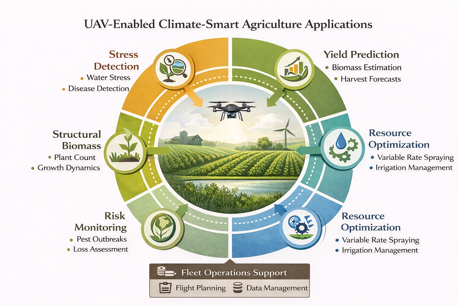
Unmanned aerial vehicle (UAV) remote sensing has evolved from experimental imaging into an operational diagnostic infrastructure supporting climate-smart agriculture through high-resolution, flexible, and timely crop observation. This review synthesizes advances in UAV platforms, multisensor payloads, artificial intelligence (AI) analytics, and multisource data fusion to evaluate their combined potential for monitoring heterogeneous smallholder systems. A PRISMA-guided analysis of 59 studies (2013–2024) classified sensing architectures, analytical approaches, and application domains across diverse agroecological contexts. Integrated UAV–AI frameworks improve detection of crop stress, yield variability, biomass distribution, and phenological dynamics compared with conventional monitoring, particularly when multimodal sensor data are fused with satellite and ground observations. Predictive performance and diagnostic reliability increase when spectral, thermal, and structural datasets are analyzed jointly using machine-learning or deep-learning models. However, scalability remains constrained by operational, infra-structural, and regulatory factors, especially in resource-limited systems. These findings demonstrate that integrated sensing–analytics systems form a critical foundation for scalable climate-smart agricultural transformation and data-driven decision support across farm, landscape, and institutional scales.
Keywords:
UAV remote sensing
; climate-smart agriculture
; artificial intelligence
; machine learning
; precision agriculture
; smallholder farming systems
; multispectral imaging
; crop monitoring
1. Introduction
Climate variability is compressing decision time for farmers: stress develops quickly, fields are increasingly heterogeneous, and conventional scouting often detects problems only after yield losses are locked in. Unmanned aerial vehicle-based remote sensing, now paired with artificial AI analytics, has moved from experimental imaging to an operational diagnostic infrastructure that can deliver timely, high-resolution insight across complex production landscapes. Synthesizing how these platforms, sensors, and analytical workflows have evolved is therefore essential for evaluating their role in climate-smart agriculture (CSA), particularly in smallholder systems where spatial variability and information constraints are most pronounced.
1.1. Advances in UAV-Based Remote Sensing for Agricultural Monitoring
Over the past decade, UAVs have evolved from experimental imaging platforms into operational remote sensing systems capable of delivering high-resolution, flexible, and cost-effective agricultural diagnostics [1,2,3,4]. Improvements in flight stability, autonomous navigation, endurance, and payload integration have expanded deployment across diverse agroecological environments [5,6,7,8]. Concurrent advances in sensor miniaturization and radiometric calibration now allow integration of RGB, multispectral, thermal, and light detection and ranging (LiDAR) payloads within compact aerial platforms [9,10,11,12,13], enabling centimeter-scale observation of crop vigor, canopy temperature, biomass structure, and phenological development [14,15,16,17].
These developments have repositioned UAV remote sensing from a data acquisition modality to a diagnostic infrastructure supporting advanced analytical workflows [18,19,20]. High spatial resolution, flexible revisit timing, and targeted deployment make UAV systems particularly suited to heterogeneous agricultural landscapes where intra-field variability strongly influences productivity and climate vulnerability [21,22,23,24]. Consequently, UAV platforms are increasingly central to precision agriculture and climate-responsive farm management strategies [25,26,27].
1.2. AI-Driven Interpretation and Multisensor Integration
Parallel advances in AI and machine learning have substantially expanded the interpretive capacity of UAV-derived imagery [28,29,30,31]. Algorithms including ensemble learning models, support vector machines, and CNNs are now widely applied to automate stress detection, disease classification, yield estimation, and crop-type discrimination from high-resolution datasets [32,33,34,35,36,37]. These approaches enable extraction of decision-relevant patterns from complex multisensor data streams that would be difficult to interpret using traditional analytical methods [38,39,40,41].
Multisource data fusion represents a further frontier in UAV-enabled monitoring [42,43,44,45]. Integrating aerial observations with satellite time series, ground measurements, and climate datasets enhances temporal continuity and cross-scale interpretability [46,47,48,49]. Feature-, model-, and decision-level fusion architectures allow fine-resolution UAV observations to be contextualized within broader environmental dynamics [50,51,52,53], thereby strengthening diagnostic reliability and predictive performance. Together, advances in platform capability, sensor integration, and AI-enabled analytics have expanded the functional scope of UAV remote sensing in agriculture [54,55,56].
1.3. Relevance to Climate-Smart Agriculture in Smallholder Systems
Climate-smart agriculture seeks to increase productivity, strengthen adaptation to climate variability, and support mitigation objectives [57,58,59]. Achieving these goals requires spatially explicit diagnostics that detect stress dynamics, structural variability, and microclimatic influences at management-relevant scales [60,61,62,63]. In smallholder-dominated systems, characterized by fragmented landholdings, heterogeneous soils, and limited monitoring infrastructure, such diagnostic precision is particularly valuable [64,65,66,67].
UAV-based remote sensing offers distinct advantages in these environments, including flexible deployment, targeted coverage, and high-resolution data acquisition at lower operational cost than conventional airborne platforms [68,69,70,71]. When combined with AI-driven analytics, these systems enable early stress detection, precision input targeting, biomass estimation, and monitoring of agroforestry and land-use dynamics relevant to mitigation outcomes [72,73,74,75,76]. Nevertheless, technological evolution has been uneven, with substantial variation in platform selection, sensor configuration, analytical methodology, and deployment models across studies [77,78,79,80]. A systematic synthesis is therefore required to clarify the current state of UAV-enabled diagnostics and identify priorities for future development.
1.4. Objectives and Scope of This Review
This review presents a PRISMA-guided synthesis of advances in UAV-based remote sensing and AI-driven diagnostics relevant to CSA in smallholder systems. We integrate evidence on platform architectures, multisensor payloads, machine-learning methodologies, and multisource data-fusion frameworks; map diagnostic applications across productivity, adaptation, and mitigation; and identify technical and operational constraints that shape scalability.
By centering heterogeneous smallholder production environments, the review clarifies where UAV-enabled sensing delivers the greatest marginal value and what is still needed for routine, decision-support deployment.
2. Review Methodology and Evidence Synthesis (PRISMA 2020)
This review followed PRISMA 2020 to ensure transparent, reproducible reporting and structured evidence synthesis [1,2,3]. PRISMA 2020 strengthens documentation of search strategies, duplicate handling, eligibility decisions, and synthesis procedures, requirements that are especially important in fast-moving, interdisciplinary UAV–AI research.
Because relevant studies span remote sensing, agronomy, computer vision, machine learning, and precision agriculture, the protocol was defined as a priori (search terms, eligibility criteria, and coding dimensions) to minimize post hoc selection and interpretive bias. The subsections below describe the identification, screening, classification, and synthesis steps used to compile evidence on UAV-based sensing and AI-driven diagnostics for CSA in smallholder contexts.
2.1. Literature Search Strategy and Information Sources
A structured, multi-database search strategy was implemented to identify peer-reviewed literature addressing advances in UAV-based remote sensing and AI-driven agricultural diagnostics. Search was conducted across Web of Science, Scopus, ScienceDirect, and Google Scholar to retrieve studies published between 2013 and 2024. All records were managed using reference management software to facilitate duplicate removal and documentation of screening decisions.
Search strings combined UAV-related terminology (“unmanned aerial vehicle,” “UAV,” “drone”) with remote sensing modalities (“multispectral,” “thermal,” “LiDAR,” “hyperspectral”) and analytical descriptors (“machine learning,” “deep learning,” “convolutional neural network,” “random forest,” “artificial intelligence”). These were further linked to agricultural context terms including “precision agriculture,” “crop monitoring,” “yield estimation,” “stress detection,” and “climate-smart agriculture.”
Boolean operators and database filters were iteratively refined to balance search sensitivity and specificity. The temporal scope was limited to publications from 2013 to 2024 to capture the period during which UAV-based agricultural sensing transitioned from exploratory experimentation to operational, multisensor diagnostic systems supported by AI-enabled interpretation [4,5,6,7]. Grey literature, regulatory reports, and technical guidance documents were reviewed selectively to contextualize deployment and airspace considerations but were excluded from the core PRISMA synthesis unless they met empirical inclusion criteria.
2.2. Inclusion and Exclusion Criteria
Inclusion criteria emphasized technological and analytical rigor consistent with structured systematic review standards [1,2,3]. Studies were retained if they employed UAV platforms for agricultural sensing, incorporated multisensor payloads such as RGB, multispectral, thermal, or LiDAR systems, applied machine learning or AI methodologies to UAV-derived imagery, and reported measurable diagnostic outputs, including yield estimation, stress detection, biomass assessment, disease classification, or vulnerability indicators relevant to climate-smart agriculture.
Studies were excluded if they relied exclusively on satellite data without UAV integration, focused primarily on UAV engineering design without agricultural application, addressed agricultural policy or governance without substantive sensing methodology, lacked sufficient methodological detail for analytical interpretation, or consisted solely of conceptual commentary without empirical or technical grounding. These criteria ensured that the retained literature reflected advances in UAV sensing architectures and analytical interpretation rather than generalized digital agriculture discourse, consistent with systematic review scoping principles [4,5].
2.3. Study Screening and Selection Process
The database search yielded 684 records. After duplicate removal (n = 110), 574 unique records remained for title and abstract screening. Screening excluded 484 records that did not meet UAV-based remote sensing inclusion criteria. Ninety full-text articles were subsequently assessed for eligibility following PRISMA 2020 guidance on staged screening and eligibility justification [1,2,3].
Following full-text evaluation, 41 articles were excluded due to ineligible study type (n = 26), insufficient methodological detail (n = 10), or duplication across datasets (n = 5). Forty-nine studies met the predefined inclusion criteria and were retained for structured qualitative synthesis.
To address terminological fragmentation within CSA research, particularly where studies reported productivity, adaptation, or mitigation outcomes without explicitly using the term “climate-smart agriculture”, a targeted pillar-specific search stream was conducted. This supplemental search strategy aligns with best practices for mitigating thematic exclusion in interdisciplinary reviews [6,7]. The targeted search yielded 16 additional records, of which 10 met inclusion criteria following screening and full-text assessment. These studies were incorporated into the synthesis, resulting in a final sample of 59 peer-reviewed studies.
The structured selection process is summarized in Figure 1, which presents the PRISMA 2020 flow diagram detailing identification, screening, eligibility assessment, and final inclusion stages.
2.4. Data Extraction and Technical Classification
A standardized coding protocol was developed to enable structured comparison across studies and to support systematic evaluation of technological progression in UAV-based remote sensing. Structured extraction frameworks are widely recommended in systematic reviews to enhance reproducibility and minimize interpretive drift [4,8].
Extracted variables included geographic location and agroecological context, crop system and production scale, UAV platform typology (fixed-wing, rotary-wing, or hybrid configurations), sensor payload configuration (RGB, multispectral, thermal, LiDAR), and documentation of radiometric calibration and preprocessing procedures. Analytical methodologies were categorized according to machine learning model class, including tree-based ensemble approaches, support vector machines, CNNs, and hybrid or ensemble architectures. Data fusion strategies were classified according to feature-level, model-level, or decision-level integration frameworks.
Diagnostic outputs were coded according to application domain, including yield estimation, nutrient or water stress detection, disease classification, biomass estimation, and related CSA-relevant indicators. This classification approach enabled cross-study comparison of sensing architectures and analytical workflows consistent with integrative evidence synthesis methodologies [8,9,10].
The geographic distribution, agroecological contexts, UAV platform types, sensor modalities, analytical methodologies, and diagnostic outputs of the 59 PRISMA-included studies are summarized in Supplementary Table S1. This tabulated classification provides the empirical basis for cross-study comparison and underpins the thematic synthesis presented in Section 3, Section 4, Section 5 and Section 6.
2.5. Analytical Framework for Evidence Synthesis
Given substantial heterogeneity in agroecological contexts, sensor specifications, flight protocols, validation metrics, and modeling architectures, quantitative meta-analysis was not methodologically appropriate. Instead, a descriptive and thematic synthesis approach was employed [8,9,10], emphasizing conceptual integration and identification of technological trajectories rather than statistical aggregation of performance metrics.
Narrative and thematic synthesis methods are particularly appropriate in interdisciplinary technology reviews where methodological heterogeneity precludes formal meta-analysis [9,11]. The synthesis therefore focused on documenting evolution in UAV platform capabilities, advances in multisensor integration, progress in AI-driven interpretation of UAV imagery, and emerging fusion architectures linking UAV and satellite datasets. Attention was given to recurring diagnostic patterns demonstrating transferability across smallholder agricultural systems.
2.6. Bias Considerations and Methodological Limitations
Potential sources of bias include publication bias toward positive diagnostic outcomes, regional concentration of UAV research activity, and variability in sensor quality, calibration standards, and flight protocols across studies. Additionally, heterogeneity in machine learning validation procedures and limited availability of longitudinal datasets constrain comparability across agroecological contexts. Consideration of such biases is recommended in systematic technology reviews to support interpretive transparency [1,12].
These limitations were mitigated through transparent documentation of search strategies, explicit inclusion and exclusion criteria, structured coding protocols, and a dual-stream search strategy designed to reduce terminological exclusion. Nonetheless, interpretive caution is warranted when extrapolating findings beyond the empirical scope of the reviewed literature.
The relationships among UAV platform architectures, sensor integration strategies, AI model classes, and diagnostic outputs are synthesized in Supplementary Table S2. This structured documentation provides a transparent audit trail supporting the evidence synthesis presented in Section 3. This diagram documents database retrieval, duplicate removal, exclusion decisions, and final study counts, providing a transparent methodological audit trail for the synthesis presented in Section 3. This structured reporting framework enhances methodological transparency and provides a reproducible audit trail for literature selection decisions
The dominance of multispectral sensing reflects its balance between spectral sensitivity, operational affordability, and analytical compatibility with machine learning workflows, enabling robust detection of crop physiological status, stress indicators, and canopy structural traits across diverse agroecological environments.
3. Technological Architecture of UAV-Enabled Agricultural Diagnostics
Advances in UAV technology have fundamentally reshaped the technical foundations of agricultural remote sensing by enabling high-resolution, flexible, and spatially targeted observation of crop systems across scales [14,15,16,17,18,19,20,54,55,56,57,58,59]. Whereas earlier monitoring frameworks relied primarily on satellite or manned airborne platforms, contemporary UAV systems provide centimeter-level spatial detail together with on-demand deployment. This combination allows data acquisition to be synchronized with crop growth stages, stress events, and management decision windows, thereby transforming UAVs from supplementary imaging tools into integrated sensing platforms capable of supporting analytical pipelines that unify spectral, thermal, structural, and temporal information streams [21,22,23,24,25,26,27,28,29,30,31,32,33,60,61,62,63,64,65,66,67].
Figure 2 illustrates how UAV platforms, sensor payloads, and AI analytics interact to generate actionable CSA diagnostics.
The framework depicts the operational workflow through which UAV platforms equipped with multispectral, hyperspectral, thermal, RGB, and LiDAR sensors acquire high-resolution field data. These data are processed through AI-driven analytical pipelines—including preprocessing, machine learning, and image analysis, to produce decision-relevant outputs. Resulting diagnostics support climate-smart functions such as crop monitoring, water management, yield estimation, and sustainability assessment. Together, these outputs enable precision interventions, risk evaluation, and resource optimization, forming a closed-loop system that integrates sensing, analytics, and management across farm and landscape scales.
This integrated configuration reflects progressive convergence across multiple innovation domains. Advances in platform engineering, sensor miniaturization, radiometric calibration, and positioning systems have expanded operational reliability and measurement precision [9,10,11,12,13,34,35,36,37,38]. In parallel, developments in AI and machine learning have enabled automated interpretation of fine-grained aerial imagery, allowing complex crop traits, physiological stress responses, and structural characteristics to be quantified with increasing analytical accuracy and efficiency [39,40,41,42,43,44,45,68,69,70,71,72]. Integration of multisource datasets, including UAV imagery, satellite observations, ground measurements, and environmental records, further enhances interpretive power by situating fine-scale observations within broader agroecological dynamics [46,47,48,49,50,51,52,53,73,74,75,76].
3.1. UAV Platform Architectures and Flight Performance
UAV platform architecture exerts a primary influence on sensing capability, operational efficiency, and diagnostic reliability. Fixed-wing platforms provide extended flight endurance and wide spatial coverage, making them well suited for landscape-scale monitoring and regional crop surveillance [9,10,11,12]. Rotary-wing systems, by contrast, offer vertical takeoff and landing, hovering capability, and high maneuverability, enabling ultra-fine plot-level imaging and targeted stress diagnostics within spatially heterogeneous fields [13,14,15,16]. Hybrid UAV configurations have recently emerged as integrative solutions that reconcile endurance with maneuverability by combining fixed-wing cruise efficiency with rotary-wing stability during takeoff, landing, and low-altitude sensing operations. Such platforms expand operational versatility and are increasingly deployed in research contexts requiring simultaneous broad coverage and high-resolution acquisition [17,18,19].
Advances in onboard inertial measurement units, real-time kinematic positioning systems, and automated flight-planning software have markedly improved flight stability, geolocation accuracy, and navigational autonomy. These developments enhance temporal repeatability across missions, an essential requirement for monitoring crop growth trajectories, stress progression dynamics, and management intervention outcomes [20,21,22,23]. Figure 3 summarizes the principal UAV platform categories and their operational characteristics across spatial scale and endurance gradients.
The figure presents a comparative framework illustrating how distinct UAV platform classes operate across increasing spatial scales and flight endurance levels, ranging from nano/micro-UAVs suited for plot-level trials and high-resolution phenotyping to multirotor systems optimized for field-scale diagnostics and disease detection. Hybrid VTOL platforms provide adaptive monitoring across intermediate scales, while fixed-wing UAVs enable large-area landscape and regional mapping due to extended flight duration and coverage capacity.
Platform selection directly influences sensing resolution, spatial coverage, and mission endurance, thereby shaping the scale and quality of data available for downstream analytical processing. By determining spatial scope and operational flexibility, UAV platform classes define the boundary conditions within which sensor integration and analytical interpretation occur. These outputs feed decision-support systems that facilitate precision interventions, risk assessment, and resource optimization, demonstrating how platform selection determines the spatial scope, diagnostic resolution, and operational efficiency of digital agriculture systems.
As illustrated in Figure 3, platform innovations have significantly broadened the functional scope of UAV deployments, enabling researchers and practitioners to align platform characteristics with monitoring objectives, spatial scale requirements, and environmental constraints. Such platform–task alignment is critical for ensuring that UAV-derived datasets constitute reliable inputs for agricultural diagnostics and decision-support systems [24,25,26,27].

Table 1.
Comparative performance characteristics of UAV platform types across operational contexts and climate-smart agriculture relevance.
Table 1.
Comparative performance characteristics of UAV platform types across operational contexts and climate-smart agriculture relevance.
| Platform Type | Key Advantages | Limitations | Best Use Context | CSA Relevance |
|---|---|---|---|---|
| Fixed-wing | Long endurance; wide coverage | Limited maneuverability | Landscape monitoring | Adaptation + Mitigation |
| Rotary-wing | Hovering; precise imaging | Short flight time | Plot-level diagnostics | Productivity |
| Hybrid | Endurance + maneuverability | Higher cost | Multi-scale monitoring | All pillars |
| Nano/micro UAV | Low cost; portable | Limited payload | Smallholder fields | Adaptation |
3.2. Multisensor Payload Integration and Remote Sensing Modalities
Rapid sensor miniaturization and payload modularity now allow UAV platforms to carry diverse imaging systems capable of capturing complementary spectral, thermal, and structural information streams. Red, green, and blue (RGB) sensors provide ultra-high-resolution visual imagery suitable for plant counting, canopy architecture analysis, and phenological monitoring [28,29,30,31]. Multispectral cameras extend diagnostic capability by recording discrete wavelength bands associated with plant physiological responses, enabling estimation of vegetation indices linked to chlorophyll concentration, biomass accumulation, and stress detection [32,33,34,35]. The principal UAV sensing modalities and their relative diagnostic performance are summarized in Figure 4.
The figure presents a comparative performance matrix illustrating how major UAV-mounted sensor modalities differ in their capacity to detect agronomic conditions including crop vigor, water stress, biomass, disease symptoms, and nutrient status. Color intensity represents increasing diagnostic sensitivity. Multispectral and hyperspectral sensors demonstrate consistently strong performance across most crop monitoring variables due to their spectral discrimination capacity, whereas thermal sensors are particularly effective for detecting canopy temperature anomalies associated with water stress. RGB sensors provide high spatial detail for visible traits but have limited sensitivity to biochemical stress signals. LiDAR systems excel in structural measurements such as biomass estimation and canopy height reconstruction, though they exhibit reduced sensitivity to physiological indicators.
Simultaneous integration of multiple sensing modalities within a single mission enables concurrent acquisition of spectral, thermal, and structural datasets. Such multisensor strategies improve diagnostic robustness by capturing complementary indicators of plant condition and environmental stress. Consequently, sensor fusion has emerged as a defining attribute of advanced UAV-based agricultural monitoring systems [44,45,46,47]. The functional relationships among sensing modalities, analytical architecture, diagnostic outputs, and climate-smart agriculture pillars are synthesized in Table 2.
While sensor modalities determine the type and quality of biophysical signals that can be captured, the agronomic value of those signals ultimately depends on analytical architectures capable of extracting interpretable and decision-relevant patterns. The following section therefore examines advances in artificial intelligence and machine learning frameworks that transform UAV-derived data into actionable agricultural diagnostics.
3.3. Artificial Intelligence and Machine Learning Analytical Architectures
The analytical utility of UAV imagery depends on computational methodologies capable of extracting biologically meaningful patterns from high-resolution datasets. Machine learning algorithms now constitute core components of UAV-enabled diagnostic pipelines. Tree-based ensemble models, including random forest and gradient boosting approaches, are widely applied for crop classification, yield prediction, and stress detection because of their resilience to nonlinear relationships and heterogeneous data structures [48,49,50,51].
Support vector machines and related classifiers remain particularly effective for high-dimensional spectral datasets, especially when training sample sizes are constrained. These algorithms have demonstrated strong performance in disease detection, nutrient deficiency identification, and crop-type discrimination derived from UAV imagery [52,53,54,55].
Deep learning architectures, most notably CNNs, have further expanded analytical capability by enabling automated feature extraction directly from raw imagery. These models are highly effective for detecting complex spatial patterns such as disease lesions, lodging events, and canopy structural anomalies. Their scalability makes them especially suitable for high-throughput phenotyping and large-area monitoring applications [56,57,58,59].
Hybrid analytical frameworks that combine machine learning algorithms with radiative transfer models or domain-specific spectral indices are increasingly employed to enhance interpretability and cross-context generalizability. By integrating data-driven prediction with process-based understanding, such approaches improve diagnostic reliability across variable agroecological environments [60,61,62,63].
Major analytical model classes, representative algorithms, and their diagnostic applications in UAV-based agriculture are summarized in Table 3.
3.4. Multisource Data Fusion and Cross-Scale Analytics
Although UAV observations provide exceptionally high spatial resolution, their temporal continuity is constrained by flight logistics, regulatory considerations, and operational costs. Integrating UAV datasets with complementary information streams, such as satellite imagery, in situ sensors, and meteorological records, addresses this limitation by enabling continuous monitoring across spatial and temporal scales [64,65,66,67]. Feature-level fusion architectures combine datasets prior to model training, allowing algorithms to exploit synergistic information from multiple sources.
Model-level fusion integrates predictions generated by independently trained algorithms, whereas decision-level fusion synthesizes outputs from distinct analytical pipelines. The analytical pipeline linking UAV data acquisition to AI-driven diagnostic outputs is illustrated in Figure 5.
As illustrated in Figure 5, analytical architectures differ in performance depending on data availability, computational infrastructure, and monitoring objectives [68,69,70,71]. Cross-scale analytics derived from multisource integration enhance interpretability by linking fine-resolution UAV observations with broader climatic and landscape-level processes. For example, UAV-derived stress indicators can be contextualized within seasonal rainfall anomalies or regional temperature trends obtained from satellite observations. Such contextual coupling improves decision relevance and strengthens inference reliability for crop performance assessment [72,73,74,75].
The integration of UAV sensing with satellite observations and environmental datasets enables cross-scale analytical frameworks that strengthen agricultural monitoring under climate variability. Such multisource fusion enhances diagnostic reliability and contextual interpretation across spatial and temporal scales. These architectures can be organized into distinct analytical levels, each with specific methodological advantages (Table 4).
Importantly, these fusion layers are not merely technical design choices; they determine how UAV-derived intelligence is translated from ecological diagnostics into operational advisory systems. By structuring integration across analytical levels, they define the technological architecture through which UAV-enabled diagnostics can be deployed across the principal domains of climate-smart agriculture.
4. Diagnostic Applications Across Climate-Smart Agriculture Domains
Technological advances in UAV platforms, multisensor payloads, AI analytics, and data fusion have established UAV-enabled sensing as a mature diagnostic infrastructure. Its value lies in generating actionable insights that address productivity, adaptation, and mitigation across heterogeneous production landscapes [57,58,59,60,61,62,63,72,73,74,75,76,77,78,79,80]. Increasingly, UAV systems function not merely as observation tools but as analytical instruments for quantifying crop condition, detecting stress dynamics, predicting yield, assessing resource efficiency, and monitoring ecosystem processes. These diagnostic domains across climate-smart agriculture pillars are synthesized in Figure 6.
As illustrated in Figure 6, diagnostic applications align with the core pillars of climate-smart agriculture, though their boundaries frequently overlap. Productivity, adaptation, and mitigation diagnostics often operate in combination because agricultural systems respond simultaneously to biophysical, climatic, and management drivers. This interdependence underscores the value of integrated sensing–analytics frameworks for generating decision-relevant intelligence across scales. Representative machine-learning applications and their alignment with climate-smart agriculture pillars are summarized in Table 5.
4.1. Productivity-Oriented Diagnostics: Yield, Growth Dynamics, and Phenotyping
Within climate-smart agriculture, productivity-oriented diagnostics aim to enhance output stability and resource-use efficiency under variable production conditions. Productivity assessment represents the most extensively investigated UAV application in agriculture, encompassing yield estimation, biomass quantification, canopy vigor assessment, and phenological monitoring [14,15,16,17,32,33,34,35,36,37,54,55,56,57,58,59].
Vegetation indices derived from multispectral imagery remain widely used indicators of crop performance. NDVI, NDRE, and SAVI are frequently applied to estimate chlorophyll status, canopy density, and photosynthetic activity correlated with yield [32,33,34,35,36,37,72,73,74,75,76]. Multi-index fusion approaches increasingly integrate spectral, structural, and thermal features to improve predictive robustness across environmental conditions.
Machine learning further strengthens predictive capability. Ensemble regression models are widely applied for yield and biomass estimation, while CNNs extract spatial patterns associated with vigor and stress [32,33,34,35,36,37,54,55,56,57,58,59]. Hybrid frameworks integrating process-based modeling with data-driven prediction enhance retrieval of biophysical parameters across growth stages [38,39,40,41,72,73,74,75,76].
High-resolution UAV phenotyping has become a major application in breeding and experimental agronomy, enabling rapid non-destructive measurement of morphological and physiological traits across large genotype populations, including canopy architecture, flowering timing, and stress responses [14,15,16,17,54,55,56,57,58,59]. Repeated flights across seasons further enable time-series analyses that support growth modeling, deviation detection, and early yield forecasting [21,22,23,24,68,69,70,71].
Methodological constraints remain, including variability in flight altitude, calibration, illumination, and preprocessing, as well as differences in validation protocols that complicate cross-study comparison [1,2,3,12]. Limited model transferability across agroecological zones also highlights the need for standardized workflows and multi-site datasets. Nevertheless, cumulative evidence demonstrates that UAV sensing provides spatially explicit, temporally resolved, and quantitatively robust productivity diagnostics supporting CSA objectives.
4.2. Adaptation-Oriented Diagnostics: Precision Resource Management and Climate Resilience
Within the climate-smart agriculture framework, adaptation-oriented diagnostics enhance resilience to climatic variability by improving the precision and timing of management interventions. Precision resource management represents one of the most operationally transformative UAV applications, enabling site-specific allocation of water, nutrients, and crop protection inputs [18,19,20,21,22,23,24,38,39,40,41,42,43,44,45].
Spectral indicators derived from multispectral and hyperspectral imagery enable prescription mapping by linking reflectance patterns to nutrient status and canopy vigor. These diagnostics support variable-rate fertilization that corrects deficiencies while limiting over-application, thereby improving nutrient-use efficiency and reducing loss pathways [54,55,56,57,58,59,60,72,73,74,75,76].
Thermal imagery similarly supports precision irrigation by revealing spatial heterogeneity in moisture conditions driven by soil texture, microtopography, or irrigation distribution inefficiencies [46,47,48,49,61,62,63]. Machine-learning analysis of spectral and textural imagery also enables early identification of pest or disease hotspots, allowing localized interventions that reduce chemical use and costs while improving containment [32,33,34,35,36,37,72,73,74,75,76].
Operational value increases when UAV diagnostics are integrated into GIS systems, farm management platforms, or mobile advisory tools that translate data into actionable recommendations. This integration is especially important in smallholder systems where limited inputs must be allocated strategically [21,22,23,24,25,26,27,64,65,66,67,68,69,70,71].
4.3. Mitigation-Oriented Diagnostics: Carbon Dynamics and Environmental Sustainability
Within climate-smart agriculture, mitigation-oriented diagnostics quantify carbondynamics, input-related emissions, and land-management practices that influence greenhouse gas balances. High-resolution UAV sensing enables spatially explicit estimation of biomass, canopy structure, and residue cover, as practical proxies for carbon stocks and sequestration potential [46,47,48,49,50,51,52,53,72,73,74,75,76].
LiDAR-derived canopy height models and structure-from-motion photogrammetry facilitate biomass estimation across crop and agroforestry systems, enabling integration of structural metrics into carbon accounting frameworks. When combined with spectral indices and machine-learning regression models, these datasets improve estimation of dry matter accumulation and residue retention, both of which are central to evaluating soil carbon enhancement strategies and reduced-tillage systems [38,39,40,41,42,43,44,45,54,55,56,57,58,59,60]. Such diagnostics provide quantitative inputs for sustainability monitoring and climate-reporting initiatives.
Precision nutrient management also contributes indirectly to mitigation by reducing excess nitrogen application and associated nitrous oxide emissions. UAV-based nutrient status mapping supports variable-rate fertilization strategies that improve nitrogen-use efficiency and limit environmental loss pathways [54,55,56,57,58,59,60,72,73,74,75,76]. Similarly, early detection of pest or disease hotspots enables localized treatment, reducing chemical inputs and energy-intensive application practices.
At broader scales, integration of UAV observations with satellite datasets and environmental records strengthens landscape-level carbon and resource-efficiency assessments. Cross-scale analytics facilitate monitoring of cover cropping, residue persistence, and biomass dynamics across heterogeneous production systems, thereby linking farm-level diagnostics with regional mitigation planning. Although methodological challenges remain, including calibration consistency and model transferability, UAV-enabled diagnostics provide increasingly robust tools for quantifying and supporting mitigation outcomes within climate-smart agricultural systems.
4.4. Climate Risk Monitoring and Early Warning Diagnostics
UAV monitoring extends beyond plot-level assessment to climate-risk detection by providing rapid, spatially explicit observations of crop responses to drought, heat, flooding, storm damage, and climate-driven pest outbreaks [18,19,20,21,22,23,24,46,47,48,49,50,51,52,53]. Thermal imagery detects canopy temperature anomalies indicative of water stress, while multispectral and hyperspectral data identify biochemical stress signatures associated with heat, nutrient imbalance, or pathogen activity [38,39,40,41,42,43,44,45,61,62,63].
Machine learning strengthens early warning systems by distinguishing among stress drivers and detecting anomalies relative to baseline conditions, enabling more targeted responses [32,33,34,35,36,37,50,51,52,53,54,55,56]. Multi-temporal monitoring further improves attribution by capturing trajectories rather than single observations, particularly when integrated with meteorological data and seasonal forecasts [46,47,48,49,72,73,74,75,76].
At institutional scales, UAV campaigns can inform regional assessments, guide extension advisories, and support rapid post-event damage evaluation where ground monitoring is sparse, shortening response times. Routine operational deployment, however, requires standardized calibration, consistent flight scheduling, robust validation datasets, and coordinated governance structures [4,5,6,7,8,54,55,56,57,58,59,60].
4.5. Constraints, Scalability, and Deployment in Smallholder Systems
Although UAV diagnostics demonstrate strong technical capability, implementation in smallholder systems is constrained more by deployment architecture than by sensing performance [4,5,6,7,8,21,22,23,24]. Multisensor payloads, calibration tools, and processing infrastructure remain costly for individual farmers, making shared-service delivery models, such as extension-integrated units, drone-as-a-service providers, or cooperative platforms, the most economically viable approaches [64,65,66,67,68,69,70,71].
Capacity limitations also influence adoption. Effective operation requires expertise spanning flight planning, calibration, preprocessing, and interpretation, and inadequate training reduces data quality and decision relevance [18,19,20,21,22,23,24,54,55,56,57,58,59,60]. Regulatory conditions further shape feasibility through certification requirements, flight permissions, and compliance constraints; where agriculture-specific regulatory pathways exist, adoption accelerates [5,6,7,8].
Data infrastructure presents additional challenges. Unmanned aerial vehicles imagery generates large datasets with heterogeneous formats, and variability in preprocessing and metadata standards can limit comparability and model transferability. Interoperable pipelines, standardized documentation, and reproducible workflows are therefore essential for scaling beyond isolated studies [38,39,40,41,42,43,44,45,50,51,52,53]. Rural infrastructure limitations, including electricity, connectivity, and computing access, can also restrict near-real-time analytics, motivating hybrid processing architectures combining local preprocessing with centralized analysis [46,47,48,49,72,73,74,75,76].
Overall, evidence indicates that scalability is a systems-design challenge requiring coordinated solutions across cost-sharing models, capacity development, regulatory clarity, and interoperable data governance. Embedding UAV diagnostics within extension and advisory ecosystems rather than deploying them as standalone tools offers the most credible pathway toward routine climate-smart implementation at scale [21,22,23,24,64,65,66,67,68,69,70,71].
While UAV-enabled diagnostics demonstrate substantial promise across CSA domains, their scalability in smallholder systems is conditioned by operational, infrastructural, and institutional realities. The principal constraints and corresponding mitigation strategies are synthesized in Table 6.
While UAV-enabled diagnostics demonstrate significant value across climate-smart agriculture domains, their long-term impact depends on coherent integration of heterogeneous data streams within scalable analytical architectures. Beyond individual applications and deployment constraints, sustained performance requires structured fusion frameworks capable of harmonizing UAV observations with satellite data, ground measurements, and environmental records. Section 5 therefore examines multisource data fusion architectures that underpin integrated agricultural intelligence systems.
5. Systems Integration, Constraints, and Scaling Pathways
Despite rapid advances in UAV platforms, sensor miniaturization, and AI analytics, translation into operational climate-smart systems remains constrained by technical, infrastructural, regulatory, and methodological barriers [12,13,14,15,16,17,18,24,25,26,27,28,29,30,31].
Performance reported under controlled conditions often degrades in real-world settings where illumination variability, atmospheric effects, canopy structure, flight geometry, and sensor calibration inconsistencies influence data quality and model transferability [19,20,21,22,23,47,48,49,50,51,52]. Such variability is amplified in smallholder systems, where fragmented plots, heterogeneous soils, and diverse management practices increase spatial complexity and challenge generalization [26,27,28,29,30,31,32,53,54,55,56].
Operational constraints, including flight regulations, endurance limits, payload trade-offs, processing requirements, and technical expertise, further restrict routine deployment, particularly in low-resource contexts with limited connectivity, unclear regulatory pathways, and constrained training capacity [41,42,43,44,45,46,57,58,59]. Consequently, real-world effectiveness depends as much on service delivery models, institutional readiness, and data governance as on sensor capability itself [34,35,36,37,38,50,51,52,53,54,55].
5.1. Evolution of UAV Sensing Architectures
The reviewed studies show a clear evolution from single-sensor imaging platforms to integrated multisensor systems designed for quantitative diagnostics. Early work relied largely on RGB imagery for visual assessment and basic index derivation, providing high spatial detail but limited biochemical sensitivity [1,2,3,4]. Multispectral payloads then became dominant because they balance spectral discrimination, manageable data volumes, and operational cost while enabling stress and vigor diagnostics across heterogeneous fields [5,6,7,8,9,10,11,12,13,14,15].
More recent research advances toward multimodal architectures combining multispectral, thermal, hyperspectral, and LiDAR sensors, enabling concurrent observation of physiological, thermal, and structural attributes relevant to adaptation and mitigation co-benefits [16,17,18,19,20,21,22,23,24,25,26,27,28,29,30,31,32]. In parallel, platform designs improved autonomy, stability, and endurance, with multirotor systems dominating smallholder/plot contexts and fixed-wing platforms supporting landscape-scale coverage; hybrids are emerging as scalable solutions for fragmented landscapes [33,34,35,36,37,38,39,40,41,42,43,44].
Improved calibration and preprocessing (reflectance panels, atmospheric correction, geometric alignment) increasingly support reproducible measurements across dates and sites, strengthening comparability and downstream model reliability [45,46,47,48,49,50,51,52,53]. Overall, sensing architectures progressed from (i) observational imaging to (ii) quantitative spectral diagnostics to (iii) integrated multimodal sensing, providing the hardware foundation for AI-enabled interpretation and data-fusion advances [54,55,56,57,58,59].
5.2. Analytical Intelligence Trajectory
Unmanned aerial vehicles analytics progressed from manual interpretation and threshold-based indices toward automated inference systems that generate decision-relevant variables at scale. Classical supervised learning (random forests, SVMs, gradient boosting, PLSR) became widely adopted because these models handle nonlinear relationships and correlated spectral predictors common in high-resolution UAV datasets [5,6,7,8,9,10,11,12].
Deep learning, especially CNNs, expanded capability for disease detection, segmentation, lodging assessment, and trait analysis by learning spatial features directly from imagery, improving automation but increasing dependence on labeled data and compute resources [13,14,15,16,17,18,19]. Hybrid approaches that combine machine learning with radiative transfer, crop growth, or energy balance models address a key limitation of purely empirical models by improving interpretability and transferability across agroecological contexts [20,21,22,23,24,25].
The literature also shows movement toward multitask and ensemble pipelines that estimate multiple variables (yield, nutrient status, canopy temperature, stress probability) from shared datasets, aligning UAV analytics with operational decision-support platforms [26,27,28,29,30,31]. Finally, explainability methods (feature importance, SHAP, sensitivity testing) are increasingly used to support agronomic validation and user trust—critical for adoption in smallholder settings [32,33,34,35,36].
5.3. Integration Trajectory: From Stand-Alone UAV Analytics to Cross-Scale Intelligence Systems
UAV deployments are shifting from stand-alone mapping toward integrated intelligence systems linking aerial imagery with satellite time series, ground sensors, meteorology, and management records [1,2,3,4,5,6,7,8,9,10]. Hierarchical fusion frameworks address the UAV trade-off of high spatial detail but limited temporal continuity by coupling UAV snapshots with continuous satellite and environmental monitoring, improving robustness for yield, biomass, and stress applications [11,12,13,14,15,16].
Temporal synchronization with climate and soil moisture data increases diagnostic value by positioning UAV flights as high-precision checkpoints within longer observational timelines rather than isolated snapshots [17,18,19,20,21,22]. Cloud computing and distributed infrastructures further reduce bottlenecks by automating orthomosaic generation, calibration, feature extraction, and inference, while improving interoperability and collaborative use [23,24,25,26,27].
Integration also increasingly includes decision-support coupling, where UAV outputs feed advisory platforms for irrigation, nutrient management, pest control, and harvest planning [28,29,30,31,32]. Institutional integration (research–extension–private provider–producer partnerships) is repeatedly identified as essential for standardization, capacity development, and scaling beyond trials, although interoperability constraints, regulation, and uneven digital infrastructure remain persistent barriers [33,34,35,36,37,38,39,40,41,42].
5.4. Implications for Climate-Smart Agricultural Systems and Scaling Pathways
Across the reviewed literature, the future impact of UAV-enabled remote sensing depends less on incremental hardware gains and more on alignment among sensing, analytics, and delivery ecosystems within heterogeneous farming contexts [1,2,3,4]. Unmanned aerial vehicle systems support CSA by providing spatially explicit, temporally responsive diagnostics, particularly for stress detection and targeted management, where within-field variability limits the utility of satellite-only approaches [5,6,7,8,9].
Scaling evidence consistently favors service-based models (cooperative hubs, extension-supported programs, private analytics providers) over individual ownership, because they distribute cost, skills, and processing burdens while enabling standardized workflows [10,11,12,13,14]. Methodological standardization remains a central prerequisite for reproducibility and regulatory acceptance, given persistent variability in calibration, preprocessing, feature extraction, and validation practices [15,16,17,18].
Cross-domain integration (UAV + satellite + climate/yield histories) strengthens early warning and forecasting capacity by linking fine-scale crop signals to broader climatic drivers [19,20,21,22,23]. Adoption is also shaped by governance: clear aviation pathways, data ownership rules, privacy safeguards, and certification processes accelerate integration, whereas ambiguity or restriction slows innovation and uptake [24,25,26,27].
Capacity development is a recurring enabling condition, since sustainable deployment requires interdisciplinary competence spanning agronomy, remote sensing, and data science; training for technicians, extension agents, and service providers improves data quality and decision relevance [28,29,30,31].
In synthesis, four interdependent pathways—technological refinement, analytical standardization, institutional integration, and capacity development—will determine whether UAV diagnostics remain specialized tools or mature into routine infrastructure for climate-smart agricultural management.
6. Constraints, Limitations, and Implementation Barriers
While Section 5 examined the evolution and integration trajectory of UAV-enabled systems, this section critically evaluates the constraints that limit widespread implementation within climate-smart agricultural contexts.
Although UAV-enabled sensing and AI-driven analytics have advanced rapidly, the reviewed literature consistently shows that translation into routine climate-smart agricultural decision support is constrained by interacting technical, methodological, regulatory, economic, and socio-institutional barriers. These constraints shape not only deployment feasibility but also the reliability, reproducibility, and equity of UAV-derived intelligence across heterogeneous production landscapes, particularly in smallholder-dominated systems where fragmentation, infrastructure gaps, and institutional capacity limitations are pronounced [1,2,3,4,21,22,23,24].
Many reported performance gains are demonstrated under controlled experimental conditions, yet real-world agricultural environments introduce variability in illumination, atmospheric dynamics, sensor calibration, and management context that can degrade data quality and reduce model transferability [12,13,14,15,16,17,18,33,34,35,36,37,38,39]. Consequently, successful scaling depends less on isolated improvements in sensors or algorithms than on coordinated systems alignment involving standardized acquisition protocols, interoperable data infrastructures, enabling governance frameworks, sustainable service-delivery architectures, and workforce development ecosystems capable of translating UAV outputs into timely and actionable agronomic intelligence [34,35,36,37,38,50,51,52,53,54,55,64,65,66,67,68,69,70,71].
Among these constraints, technical limitations represent the most immediate determinants of operational performance, because they directly affect data accuracy, analytical reliability, and diagnostic validity across environments.
6.1. Technical Limitations
Despite rapid advances in UAV platforms and analytical pipelines, persistent technical constraints continue to affect reliability, scalability, and operational robustness in climate-smart agricultural diagnostics. These limitations arise from hardware trade-offs, sensor variability, environmental sensitivity, and processing requirements that collectively influence data quality and interpretability across heterogeneous agroecosystems [1,2,3,4].
Platform endurance remains a primary constraint. Rotary-wing UAVs typically operate for only 15–40 min, restricting spatial coverage and requiring multiple sorties for medium-scale monitoring [5,6,7]. Fixed-wing systems offer longer endurance but lack maneuverability for fine-scale imaging in fragmented smallholder landscapes [8,9,10]. Hybrid platforms partially mitigate this trade-off but remain limited by payload weight and power demands that restrict sensor integration [11,12,13].
Sensor variability further affects analytical reliability. Multispectral and hyperspectral systems differ in spectral resolution, signal-to-noise ratio, and radiometric stability, producing cross-platform inconsistencies in vegetation indices and derived parameters [14,15,16,17]. Thermal sensors are especially sensitive to atmospheric conditions, emissivity assumptions, and flight altitude, which can introduce systematic bias without rigorous calibration [18,19,20,21]. LiDAR systems provide precise structural measurements but remain costly and energy-intensive, limiting routine deployment in resource-constrained contexts [22,23,24].
Environmental conditions also influence acquisition quality. Wind, solar angle, cloud cover, and aerosols affect flight stability, image sharpness, and illumination consistency [25,26,27,28]. Variable lighting can introduce spectral artifacts unless robust normalization procedures are applied [29,30,31], a challenge particularly acute in tropical regions with rapidly changing weather patterns [32,33,34].
Processing demands constitute another bottleneck. High-resolution imagery requires substantial computational resources for mosaicking, georeferencing, feature extraction, and model inference [35,36,37,38]. Many workflows depend on specialized software and high-performance computing infrastructure that are not universally accessible [39,40,41]. Differences in preprocessing pipelines can also yield divergent outputs from identical datasets, complicating reproducibility and cross-study comparison [42,43,44].
Validation limitations further constrain confidence. Many studies rely on small ground-truth datasets due to logistical constraints, potentially inflating performance metrics and reducing generalizability [45,46,47]. The absence of standardized validation protocols exacerbates comparability challenges across studies [48,49,50]. Interoperability remains a final technical barrier. Proprietary file formats, inconsistent metadata, and platform-specific calibration procedures restrict data portability and integration with other datasets [51,52,53,54], limiting development of standardized monitoring frameworks.
In sum, UAV diagnostics have matured technically but remain operationally contingent on hardware capacity, environmental conditions, calibration rigor, and computational infrastructure. Addressing these constraints through improved engineering, standardization, and interoperable data architectures is essential for reliable climate-smart deployment.
6.2. Data and Model Transferability Constraints
A major methodological barrier to scaling UAV diagnostics lies in limited transferability of analytical models across locations, seasons, and production systems. While machine learning models often perform well within training environments, accuracy frequently declines in new contexts because model performance is strongly conditioned by training data distributions, sensor configurations, and environmental variability [1,2,3,4].
Spectral–biophysical relationships are inherently site-specific. Reflectance signatures depend not only on plant physiology but also on soil background, illumination geometry, atmosphere, and management practices. Consequently, models calibrated in one environment often perform poorly elsewhere unless recalibrated [5,6,7,8,9]. Sensor heterogeneity compounds this problem. Differences in spectral band placement, radiometric resolution, and calibration protocols produce non-equivalent measurements across cameras, limiting cross-sensor transferability [10,11,12,13].
Temporal variability introduces additional instability. Crop reflectance evolves through phenological stages, and seasonal changes in solar angle, moisture, and atmosphere alter spectral signals [14,15,16,17]. Models trained on narrow temporal datasets risk overfitting to specific conditions rather than capturing generalizable relationships.
Scale mismatch further constrains application. UAV data operate at centimeter resolution, whereas regional monitoring systems function at coarser scales. Translating fine-resolution relationships requires explicit scaling strategies; otherwise, models may perform well locally but fail regionally [18,19,20,21].
Small training datasets remain a fundamental limitation. Many UAV studies rely on limited samples due to field data collection constraints, increasing the likelihood that models capture site-specific noise rather than generalizable patterns [22,23,24,25].
Emerging solutions include transfer learning, domain adaptation, ensemble modeling, and physics-informed AI approaches, which improve cross-context robustness by embedding mechanistic constraints or enabling adaptive retraining [26,27,28,29,30,31,32,33]. Standardization initiatives, shared datasets, harmonized calibration, and common validation metrics, also enhance comparability and transferability [34,35,36,37].
These challenges are particularly pronounced in smallholder systems characterized by high environmental and management variability [38,39,40,41]. Advancing from localized proof-of-concept to scalable implementation therefore requires prioritizing robustness, adaptability, and dataset diversity rather than optimizing performance within narrow experimental conditions.
6.3. Regulatory and Airspace Challenges
Regulatory frameworks represent one of the most influential non-technical constraints on UAV deployment. Technological innovation has advanced rapidly, but policy adaptation has been uneven, producing fragmented regulatory environments that create operational uncertainty for researchers and service providers [1,2,3,4].
Most UAV operations fall under aviation regulations originally designed for crewed aircraft. Requirements such as certification, line-of-sight operation, altitude limits, and flight approvals can restrict flexibility in time-sensitive agricultural applications [5,6,7,8,9]. Restrictions on beyond-visual-line-of-sight operations are particularly limiting because they reduce coverage efficiency. Regulatory heterogeneity across jurisdictions further complicates implementation. Differences in licensing, certification, and data rules increase administrative burden and hinder cross-border research or technology transfer [10,11,12,13].
Data governance regulations introduce additional complexity. High-resolution imagery may capture sensitive information beyond target fields, necessitating protocols for anonymization, storage, and consent [14,15,16,17]. Insurance, registration, and liability requirements also raise entry costs, especially for small organizations [18,19,20,21]. Infrastructure constraints can interact with regulatory requirements. Digital flight authorization or geofencing systems often require reliable connectivity, which may be lacking in rural regions [22,23,24,25].
Encouragingly, regulatory environments are evolving. Risk-based frameworks that differentiate low-risk agricultural flights from higher-risk operations are increasingly adopted [26,27,28,29]. International harmonization initiatives aim to standardize procedures and data governance principles, reducing administrative barriers and supporting scalable service ecosystems [30,31,32,33]. Ultimately, regulatory environments determine where and how UAV systems can be deployed. Advancing climate-smart diagnostics therefore depends as much on adaptive governance as on technological innovation.
6.4. Economic and Infrastructure Barriers
Economic and infrastructural conditions strongly influence whether UAV technologies transition from experimental tools to operational agricultural systems. Total deployment costs extend well beyond hardware acquisition to include sensors, software, processing infrastructure, training, and logistics [1,2,3,4]. Advanced payloads such as hyperspectral or LiDAR sensors can exceed the cost of the UAV itself, and research-grade workflows often require calibration tools and specialized software [5,6,7,8,9]. Operational expenses—including personnel, maintenance, licensing, and compliance—further increase long-term costs [10,11,12,13].
Infrastructure availability is equally critical. UAV workflows depend on reliable electricity and internet connectivity for charging, data transfer, and cloud processing. In regions with limited digital infrastructure, delays in processing can reduce decision relevance [14,15,16,17]. Processing requirements present additional challenges. Large datasets demand substantial computing capacity, and limited access to high-performance systems can restrict analytical complexity [18,19,20,21].
These barriers are most pronounced in smallholder systems with limited capital and narrow profit margins [22,23,24,25,26]. Consequently, collective service models, cooperatives, and public–private partnerships are often more viable than individual ownership. Market maturity also affects affordability: regions with established service ecosystems typically exhibit lower costs and greater reliability [27,28,29,30].
6.5. Adoption Constraints in Smallholder Systems
Adoption in smallholder systems is shaped not only by cost or regulation but by structural and socio-technical realities. Fragmented landholdings, heterogeneous soils, mixed cropping, and limited technical services influence both feasibility and perceived value of UAV diagnostics [1,2,3,4]. Scale compatibility is a major issue. Many UAV workflows are optimized for large fields, whereas smallholder landscapes consist of numerous irregular plots, increasing operational complexity and analytical uncertainty [5,6,7,8].
Technical literacy also affects adoption. UAV diagnostics involve multiple processing steps, and without training or extension support, outputs may appear inaccessible or difficult to interpret [9,10,11,12]. Trust is equally important. Farmers adopt technologies when results are consistent, interpretable, and demonstrably beneficial. Variability caused by weather, calibration differences, or algorithm uncertainty can reduce confidence [13,14,15,16].
Institutional intermediaries play a crucial role. Extension services, cooperatives, and service providers often determine whether technologies reach farmers [17,18,19,20]. Cultural compatibility also matters innovations are more readily adopted when they integrate with existing practices rather than replace them [21,22,23,24]. Infrastructure disparities further constrain use. Limited connectivity or digital literacy can make advanced outputs unusable unless translated into simple advisory formats [25,26,27,28].
Service-based delivery models offer promising solutions. Cooperative platforms, community drone hubs, and shared services distribute costs and technical responsibilities while maintaining professional standards [29,30,31,32]. Timeliness is equally critical; insights must be delivered within agronomic decision windows to retain practical value [33,34,35,36]. Encouragingly, adoption barriers are gradually declining as hardware prices fall, interfaces simplify, and training programs expand [37,38,39,40]. Long-term adoption will depend on coordinated progress in technology design, extension systems, infrastructure, and farmer engagement. Cross-platform sensing integration is conceptualized in Figure 7.
The figure presents a hierarchical architecture illustrating how multiple data streams, including UAV-acquired imagery, satellite observations, and ground-based environmental sensor measurements, are integrated to generate comprehensive agricultural intelligence. UAV platforms equipped with RGB, multispectral, thermal, and LiDAR sensors provide high-resolution field observations that are combined with satellite-derived spatial datasets and in situ environmental measurements such as meteorological variables. These heterogeneous data sources are harmonized through multisource integration and preprocessing workflows, enabling robust environmental characterization and cross-scale analysis.
Supporting operational infrastructure, including flight planning, calibration, and data management, ensures data quality and system reliability. The integrated datasets feed analytical and modeling processes that support sustainability assessment and risk metrics, ultimately informing decision-support systems capable of guiding precision management and climate-resilient agricultural strategies across spatial scales.
As shown in Figure 7, robust agricultural intelligence emerges from coordinated integration of aerial, satellite, and in situ sensing systems rather than reliance on any single data source. Multisource fusion enhances interpretability by linking fine-resolution field observations with broader environmental dynamics, thereby improving analytical confidence and decision relevance across spatial and temporal scales.
Collectively, these constraints underscore that advancing UAV-enabled climate-smart agriculture requires coordinated progress beyond hardware and algorithmic innovation. Technical reliability, model transferability, regulatory clarity, economic accessibility, and institutional capacity must evolve in parallel to ensure that UAV-derived intelligence is robust, equitable, and operationally viable. Without such systemic alignment, technological advances risk remaining confined to pilot projects rather than maturing into routine decision-support infrastructure for heterogeneous agricultural systems.
7. Policy, Governance, and Scaling Pathways
Scaling UAV-enabled remote sensing from pilot studies to operational agricultural infrastructure depends as much on governance and institutional readiness as on technological maturity. Although Section 3, Section 4, Section 5 and Section 6 document major progress in UAV platforms, multisensor payloads, AI analytics, and diagnostic applications, impact at scale is mediated by regulatory clarity, institutional coordination, financing, and cross-sector implementation capacity [1,2,3,4]. Because UAV-enabled sensing intersects aviation, data governance, telecommunications, environmental regulation, and extension systems, fragmented policy environments can raise costs and delay deployment, whereas coherent governance architectures can accelerate responsible scaling and innovation [5,6,7,8,9].
Scaling also requires institutional models that sustain service delivery and ensure that UAV-derived information moves reliably from data acquisition to actionable advisory outputs; without clear roles, interoperability standards, and coordinated workflows, technical capability rarely translates into routine decision support [10,11,12,13,14]. Data governance is central to legitimacy because high-resolution imagery can expose sensitive information about land use and management; transparent frameworks defining ownership, access rights, privacy safeguards, and benefit sharing are therefore essential for trust and long-term participation, especially in smallholder contexts [15,16,17,18,19]. Financial sustainability similarly shapes scaling trajectories: service-based approaches (public–private partnerships, cooperative models, government-supported digital agriculture programs) often outperform individual ownership by reducing entry barriers while maintaining quality assurance and operational oversight [20,21,22,23,24].
Finally, governance must remain adaptive as UAV sensors and analytical algorithms evolve quickly; iterative, evidence-based regulation that incorporates stakeholder feedback is increasingly recognized as essential for managing emerging technologies in complex socio-technical systems [25,26,27,28,29]. When embedded within national agricultural information systems, UAV diagnostics can support early warning, climate-risk assessment, and landscape-scale planning, making governance the factor that determines whether UAVs remain isolated tools or become foundational components of climate-smart agricultural intelligence infrastructures [30,31,32,33,34].
7.1. Regulatory Frameworks and Airspace Governance
Regulatory frameworks are among the strongest determinants of whether UAV agriculture transitions from experimental use to routine deployment. UAV operations intersect controlled airspace rules and data protection regimes, and the literature consistently links adoption to regulatory clarity, procedural efficiency, and interagency coordination, while ambiguity increases delays and compliance burdens [1,2,3,4,5]. Aviation requirements—operator certification, registration, authorization processes, and operational limits, are necessary for safety but can constrain time-sensitive agricultural missions unless low-risk agricultural pathways (e.g., tiered licensing, standing permissions, corridor-based approvals) are implemented [6,7,8,9,10]. Flexible airspace governance enables more frequent monitoring aligned with crop growth stages and stress events, while rigid classification can restrict coverage and responsiveness [11,12,13,14].
Performance-based standards are often preferred over technology-specific certification because they protect quality without blocking innovation in sensors and payloads [15,16,17,18]. Clear data governance rules are equally important because imagery may capture areas beyond target fields; defined stewardship, storage, sharing, and privacy protocols increase stakeholder acceptance and program continuity [19,20,21,22,23]. Adoption also depends on institutional capacity: digitized permitting systems, trained regulators, and coordinated oversight reduce uncertainty and accelerate deployment [24,25,26,27,28,29,30,31]. In smallholder systems, streamlined, decentralized procedures and locally accredited training can improve equity by enabling participation of community-based service providers [32,33,34,35].
7.2. Institutional Architectures and Implementation Models
UAV diagnostics scale through institutions, not hardware alone. The literature identifies three dominant implementation pathways: research-led models that advance methods but often lack continuity; private service-provider models that enable rapid diffusion but can be costly for smallholders; and cooperative/intermediary models that aggregate demand and translate analytics into advice, making them particularly relevant for smallholder landscapes [21,22,23,24,25,26,27,64,65,66,67,72,73,74,75,76]. Hybrid architectures linking researchers, extension services, and private analytics providers often perform best because they distribute specialized functions across actors and reduce operational bottlenecks [46,47,48,49,50,51,52,53,77,78,79,80].
Successful scaling also requires governance protocols defining data ownership, liability, compliance, and analytical validation; ambiguity in these areas can constrain adoption even when technical performance is strong [54,55,56,57,58,59]. Financial viability typically depends on blended funding (public investment, partner support, user contributions) with gradual movement toward sustainable cost-recovery models as capacity and value perception increase [64,65,66,67,68,69,70,71]. Capacity development is integral to institutional design because durable deployment depends on trained operators, analysts, and extension intermediaries rather than external service dependence [72,73,74,75,76].
Because climate-smart agriculture requires coordinated improvements in productivity, adaptation, and mitigation, UAV deployment models must be assessed not only for operational feasibility but also for their capacity to advance CSA objectives across heterogeneous farming systems. Table 7 compares the principal deployment models in terms of institutional structure, operational characteristics, and contextual suitability.
7.3. Data Governance, Ownership, and Ethical Frameworks
As UAV systems become embedded in advisory and monitoring infrastructures, data governance and ethics increasingly determine legitimacy. Recurring issues include ownership, access control, and analytical transparency. Farmer-centered or cooperative ownership models often strengthen trust and participation, while opaque ownership can suppress adoption [64,65,66,67,72,73,74,75,76]. Tiered access systems aligned with stakeholder roles reduce misuse risk while preserving decision utility [21,22,23,24,25,26,27,54,55,56,57,58,59]. Because AI-driven analytics may function as “black boxes,” explainable AI approaches that clarify drivers of predictions and communicate uncertainty are increasingly emphasized to sustain trust and enable validation [28,29,30,31,32,33,46,47,48,49].
Ethical deployment also requires equity safeguards; without inclusive governance, UAV services may disproportionately benefit well-resourced producers. Cooperative arrangements, public extension integration, and subsidies can improve inclusivity while aligning with CSA objectives [57,58,59,60,61,62,63,68,69,70,71]. Cross-border processing and cloud infrastructures introduce sovereignty and compliance concerns, motivating harmonized standards for agricultural data exchange and interoperability [46,47,48,49,50,51,52,53,77,78,79,80]. Overall, strong governance systems align data rights, transparency, and accountability to support sustained adoption beyond pilot stages [54,55,56,57,58,59,72,73,74,75,76].
7.4. Capacity Development, Training Ecosystems, and Workforce Formation
Workforce readiness is a decisive determinant of operational scalability. UAV deployment requires reliable flight execution, calibration rigor, geospatial processing, and AI analytics; weak training can introduce systematic errors that undermine decision reliability [14,15,16,17,21,22,23,24,54,55,56,57,58,59]. Effective programs therefore institutionalize certification, standardized operating procedures, and analytical training pipelines, often separating acquisition teams from data science specialists for efficiency and quality control [28,29,30,31,32,33,46,47,48,49]. Universities, research institutes, vocational programs, and extension systems are repeatedly identified as hubs for building durable competence, and regions with established training ecosystems exhibit more sustained adoption [60,61,62,63,68,69,70,71].
Decentralized training models—cooperative hubs, youth drone programs, extension-embedded capacity building, are particularly relevant for smallholders because they improve local ownership and reduce dependence on external providers [64,65,66,67,72,73,74,75,76]. Given rapid technological change, continuous professional development and peer-learning networks are also essential for maintaining operational relevance [1,2,3,8,9,10]. In sum, sensors and algorithms create potential, but skilled personnel and institutional learning systems determine whether UAV-enabled diagnostics deliver durable CSA gains at scale [54,55,56,57,58,59,72,73,74,75,76].
8. Future Research Directions and Strategic Priorities
Building on these institutional and operational insights, the next frontier of research must address improved spatial resolution, automation, and diagnostic precision in agricultural monitoring; however, the reviewed literature indicates that technological advancement has progressed faster than the development of integrative research frameworks capable of guiding systematic deployment within climate-smart agriculture (CSA) systems [54,55,56,57,58,59]. As UAV platforms transition from experimental tools to operational infrastructure, future research must move beyond incremental technical refinement toward coordinated innovation across sensing architectures, analytical methodologies, integration frameworks, and institutional implementation models. Progress across these dimensions is essential for transforming UAV diagnostics into scalable agricultural intelligence systems that support productivity, adaptation, and mitigation objectives in diverse agroecosystems.
A primary research priority concerns next-generation sensing architectures. Although multispectral and RGB sensors dominate current deployments, emerging hyperspectral, thermal–LiDAR hybrid, and miniaturized radar payloads offer expanded diagnostic capability for detecting physiological stress, structural variation, and sub-canopy processes. Comparative benchmarking across crops, climates, and atmospheric conditions remains limited, underscoring the need for standardized performance evaluation frameworks capable of informing evidence-based platform selection and preventing technological fragmentation [14,15,16,17,21,22,23,24].
Advances in AI represent a second critical frontier. Many existing models are trained on localized datasets, limiting generalizability across regions and management systems. Future work should prioritize transferable analytical architectures trained on multi-regional datasets and supported by approaches such as transfer learning, federated learning, and physics-informed modeling, which can improve robustness while reducing dependence on site-specific calibration [28,29,30,31,32,33,46,47,48,49]. Shared benchmark datasets and open validation protocols would further accelerate methodological convergence and reproducibility.
Cross-scale integration constitutes a third strategic priority. Most UAV studies remain plot-scale, yet CSA decision-making requires diagnostics linking field conditions to landscape and regional dynamics. Research should therefore focus on hierarchical fusion frameworks integrating UAV imagery with satellite time series, ground sensors, and climate datasets. Such systems could enable continuous monitoring, early warning diagnostics, and adaptive management grounded in both fine-resolution measurements and broader environmental context [42,43,44,45,46,47,48,49].
Standardization represents another essential research direction. Substantial heterogeneity persists in flight protocols, calibration procedures, feature extraction methods, and validation metrics, limiting cross-study comparability and cumulative knowledge synthesis. Coordinated initiatives to harmonize acquisition protocols, preprocessing pipelines, and reporting standards would strengthen scientific rigor, facilitate meta-analysis, and support regulatory evaluation of UAV-derived diagnostics [1,2,3,4,8,9,10].
Equally important is expanded socio-technical research. Technological performance alone does not determine real-world impact; adoption depends on institutional capacity, economic feasibility, governance structures, and user acceptance. Interdisciplinary investigations integrating agronomy, geospatial science, economics, and rural sociology are needed to evaluate implementation pathways, service delivery models, and decision outcomes in heterogeneous farming systems, particularly in smallholder contexts where variability and resource constraints are pronounced [60,61,62,63,64,65,66,67,72,73,74,75,76].
Longitudinal evidence is also urgently needed. Many UAV applications are assessed over single growing seasons, limiting understanding of interannual variability, climatic sensitivity, and temporal stability. Multi-season monitoring programs would enable evaluation of algorithm robustness under fluctuating environmental conditions and provide stronger validation of UAV diagnostics as reliable components of agricultural monitoring systems rather than short-term experimental tools [14,15,16,17,54,55,56,57,58,59].
Finally, future research should emphasize system-level integration rather than isolated technological optimization. Emerging evidence suggests that the greatest advances will arise not from improvements in individual sensors or algorithms but from interoperable sensing networks, standardized data infrastructures, and decision-support platforms that translate aerial observations into actionable management guidance. This systems perspective aligns with broader transitions in digital agriculture and climate adaptation science, where technological transformation is most effective when embedded within coordinated analytical and institutional ecosystems [42,43,44,45,46,47,48,49,68,69,70,71].
In summary, advancing UAV-enabled agricultural monitoring requires coordinated progress in sensing innovation, analytical intelligence, cross-scale integration, methodological standardization, and socio-technical implementation research. Addressing these priorities will enable the next generation of UAV systems to move beyond demonstration-scale achievements toward durable, scalable monitoring frameworks capable of supporting climate-smart agriculture across diverse production environments.
9. Conclusions and Strategic Outlook
Advances in UAV–based remote sensing and AI–enabled analytics are transforming agricultural monitoring by enabling spatially explicit diagnostics at resolutions and temporal frequencies unattainable through conventional observation systems. This review synthesized evidence from 59 peer-reviewed studies to evaluate technological, analytical, and operational developments shaping UAV-enabled decision support within the CSA frameworks. Across diverse crops, environments, and management systems, the literature consistently demonstrates that integrating high-resolution UAV sensing with machine-learning interpretation substantially improves detection of crop stress, estimation of biomass and yield, monitoring of disease dynamics, and assessment of environmental variability. These capabilities directly support the core objectives of CSA by strengthening productivity, enhancing adaptive capacity, and enabling monitoring of mitigation-relevant indicators.
The synthesis further indicates that recent advances in sensor miniaturization, radiometric calibration, and multisource data integration are redefining UAV platforms from stand-alone imaging tools into components of distributed agricultural intelligence systems. Analytical progress, particularly in CNNs, ensemble learning, and hybrid modeling frameworks, has accelerated automation of diagnostic workflows and reduced dependence on manual interpretation. At the same time, persistent methodological heterogeneity in calibration procedures, validation strategies, and model transferability remain a critical constraint limiting cross-context comparability and operational scaling.
A central finding of this review is that technological sophistication alone does not ensure impact. The effectiveness of UAV-enabled diagnostics depends equally on enabling conditions, including regulatory clarity, institutional coordination, data governance frameworks, and sustainable service-delivery models. In spatially heterogeneous and smallholder-dominated agricultural systems, these contextual factors determine whether UAV technologies function as isolated research instruments or evolve into scalable decision-support infrastructure. Emerging implementation pathways, including cooperative drone services, public–private analytical platforms, and community-embedded technical networks, illustrate how advanced sensing systems can be integrated into agricultural advisory and climate-adaptation ecosystems.
Several strategic priorities emerge for advancing the field. First, standardized protocols for calibration, validation, and reporting are needed to strengthen reproducibility and facilitate comparative synthesis across agroecological zones. Second, improved approaches to model generalization and transfer learning are required to extend algorithm performance across crops, climates, and sensor platforms. Third, multimodal data-fusion frameworks linking UAV observations with satellite, climatic, and ground-based datasets will be essential for achieving temporal continuity and cross-scale interpretability. Finally, interdisciplinary collaboration among agronomists, remote sensing scientists, data scientists, policymakers, and extension institutions will be necessary to translate technical capability into operational agricultural intelligence systems.
Taken together, the evidence indicates that UAV-based sensing, when integrated with artificial intelligence and embedded within supportive governance and institutional ecosystems, is evolving into a foundational component of climate-smart agricultural diagnostics. The transition from experimental deployment to scalable implementation is already underway, but its trajectory will depend on coordinated progress across technological, methodological, and socio-institutional domains. Rather than representing a discrete innovation, UAV-enabled monitoring should therefore be understood as part of a broader transformation toward integrated, data-driven agricultural systems capable of supporting resilient and sustainable food production under accelerating climatic change.
Supplementary Materials
The following supporting information can be downloaded at the website of this paper posted on Preprints.org.
Strategic Outlook
The next phase of development will likely be defined not by individual technological breakthroughs but by the convergence of sensing, analytics, and institutional integration into coherent agricultural intelligence infrastructures. Systems that successfully align these elements will enable continuous monitoring, predictive decision support, and adaptive management across spatial scales, from field plots to regional production landscapes. In this emerging paradigm, UAV platforms function not merely as observational tools but as adaptive sensing nodes within distributed agricultural knowledge systems. Designing such systems deliberately, inclusively, and sustainably will be essential for ensuring that advances in aerial sensing translate into measurable gains in productivity, resilience, and environmental stewardship across global agricultural systems. Standardized benchmarking datasets and cross-regional validation protocols will be essential for accelerating methodological convergence in UAV-enabled agricultural diagnostics.
Author Contributions
Conceptualization, A.M. methodology; J.D.O.; validation, A.M; T. L; formal analysis, A.M., J.D.O; investigation, A.M. T.L.; writing-original draft preparation, A.M.; writing—review and editing, J.D.O.; supervision, A.M.; project administration, A.M. All authors have read and agreed to the published version of the manuscript
Funding
This research received no external funding.
Acknowledgments
During the preparation of this manuscript, the authors used ChatGPT (OpenAI, GPT-5.2) for language editing and organizational support. All outputs were reviewed and verified by the authors, who assume full responsibility for the final content.
Conflicts of Interest
Author Thomas Lawler was employed by the company Indigo Ag. The remaining authors declare that the research was conducted in the absence of any commercial or financial relationships that could be construed as a potential conflict of interest
References
- Wahab, I.; Hall, O.; Jirström, M. Remote sensing of yields: Application of UAV imagery-derived NDVI for estimating maize vigor and yields in complex farming systems in sub-Saharan Africa. Drones 2018, 2, 28. [Google Scholar] [CrossRef]
- Yonah, I.B.; Mourice, S.K.; Tumbo, S.D.; Mbilinyi, B.P.; Dempewolf, J. Unmanned aerial vehicle-based remote sensing in monitoring smallholder, heterogeneous crop fields in Tanzania. Int. J. Remote Sens. 2018, 39, 5453–5471. [Google Scholar] [CrossRef]
- Schut, A.G.T.; Traore, P.C.S.; Blaes, X.; de By, R.A. Assessing yield and fertilizer response in heterogeneous smallholder fields with UAVs and satellites. Field Crops Res. 2018, 221, 98–107. [Google Scholar] [CrossRef]
- Buthelezi, S.; Mutanga, O.; Sibanda, M.; Odindi, J.; Clulow, A.D.; Chimonyo, V.G.P.; Mabhaudhi, T. Assessing the prospects of remote sensing maize leaf area index using UAV-derived multi-spectral data in smallholder farms. Remote Sens. 2023, 15, 1597. [Google Scholar] [CrossRef]
- Ayamga, M.; Tekinerdogan, B.; Kassahun, A. Exploring the challenges posed by regulations for the use of drones in agriculture in the African context. Land 2021, 10, 164. [Google Scholar] [CrossRef]
- Ayamga, M.; Tekinerdogan, B.; Kassahun, A. Developing a policy framework for adoption and management of drones for agriculture in Africa. Technol. Anal. Strateg. Manag. 2021, 33, 955–968. [Google Scholar] [CrossRef]
- FAO. E-Agriculture in Action: Drones for Agriculture; FAO & ITU: Rome, Italy, 2018. [Google Scholar]
- Reichstein, M.; Camps-Valls, G.; Stevens, B.; Jung, M.; Denzler, J.; Carvalhais, N.; Prabhat. Deep learning and process understanding for data-driven Earth system science. Nature 2019, 566, 195–204. [Google Scholar] [CrossRef]
- Samek, W.; Wiegand, T.; Müller, K.-R. Explainable artificial intelligence: Understanding, visualizing and interpreting deep learning models. IT Prof. 2017, 19, 38–45. [Google Scholar] [CrossRef]
- Arrieta, A.B.; Díaz-Rodríguez, N.; Del Ser, J.; Bennetot, A.; Tabik, S.; Barbado, A.; et al. Explainable artificial intelligence (XAI): Concepts, taxonomies, opportunities and challenges toward responsible AI. Inf. Fusion 2020, 58, 82–115. [Google Scholar] [CrossRef]
- FAO. Climate-Smart Agriculture: Policies, Practices and Financing for Food Security, Adaptation and Mitigation; FAO: Rome, Italy, 2010. [Google Scholar]
- FAO. Climate-Smart Agriculture Sourcebook; FAO: Rome, Italy, 2013. [Google Scholar]
- FAO. Digital Agriculture Transformation in Africa: Opportunities and Challenges; FAO: Rome, Italy, 2022. [Google Scholar]
- World Bank. Digital Agriculture: From Buzzword to Impact; World Bank: Washington, DC, USA, 2019. [Google Scholar]
- World Bank. Agriculture Innovation Systems: An Investment Sourcebook; World Bank: Washington, DC, USA, 2012. [Google Scholar]
- Page, M.J.; McKenzie, J.E.; Bossuyt, P.M.; Boutron, I.; Hoffmann, T.C.; Mulrow, C.D.; et al. The PRISMA 2020 statement. BMJ 2021, 372, n71. [Google Scholar] [CrossRef] [PubMed]
- Rockström, J.; Steffen, W.; Noone, K.; Persson, Å.; Chapin, F.S.; Lambin, E.F.; et al. A safe operating space for humanity. Nature 2009, 461, 472–475. [Google Scholar] [CrossRef] [PubMed]
- Folke, C.; Biggs, R.; Norström, A.V.; Reyers, B.; Rockström, J. Social-ecological resilience and biosphere-based sustainability science. Ecol. Soc. 2016, 21, 41. [Google Scholar] [CrossRef]
- Scoones, I.; Stirling, A.; Abrol, D.; Atela, J.; Charli-Joseph, L.; Eakin, H.; et al. Transformations to sustainability. Curr. Opin. Environ. Sustain. 2020, 42, 65–75. [Google Scholar] [CrossRef]
- Thornton, P.K.; Rosenstock, T.; Förch, W.; Lamanna, C.; Bell, P.; Henderson, B.; Herrero, M. A qualitative evaluation of CSA options in Africa. Reg. Environ. Chang. 2018, 18, 2003–2016. [Google Scholar] [CrossRef]
- Berni, J.A.J.; Zarco-Tejada, P.J.; Suárez, L.; Fereres, E. Thermal and narrowband multispectral remote sensing for vegetation monitoring from UAV platforms. Remote Sens. Environ. 2009, 113, 1922–1935. [Google Scholar] [CrossRef]
- Zarco-Tejada, P.J.; González-Dugo, V.; Berni, J.A.J. Fluorescence, temperature and narrow-band indices for water stress detection using UAV imagery. Remote Sens. Environ. 2012, 117, 322–337. [Google Scholar] [CrossRef]
- Zhang, C.; Kovacs, J.M. The application of small unmanned aerial systems for precision agriculture: A review. Precis. Agric. 2012, 13, 693–712. [Google Scholar] [CrossRef]
- Mulla, D.J. Twenty five years of remote sensing in precision agriculture: Key advances and remaining knowledge gaps. Biosyst. Eng. 2013, 114, 358–371. [Google Scholar] [CrossRef]
- Maxwell, A.E.; Warner, T.A.; Fang, F. Implementation of machine-learning classification in remote sensing: An applied review. Int. J. Remote Sens. 2018, 39, 2784–2817. [Google Scholar] [CrossRef]
- Asner, G.P.; Mascaro, J.; Muller-Landau, H.C.; Vieilledent, G.; Rasamoelina, M. A universal airborne LiDAR approach for tropical forest carbon mapping. Oecologia 2012, 168, 1147–1160. [Google Scholar] [CrossRef]
- Saatchi, S.S.; Harris, N.L.; Brown, S.; Lefsky, M.; Mitchard, E.T.A.; Salas, W.; Zutta, B.R.; et al. Benchmark map of forest carbon stocks in tropical regions across three continents. Proc. Natl. Acad. Sci. USA 2011, 108, 9899–9904. [Google Scholar] [CrossRef]
- Gibbs, H.K.; Brown, S.; Niles, J.O.; Foley, J.A. Monitoring and estimating tropical forest carbon stocks: Making REDD a reality. Environ. Res. Lett. 2007, 2, 045023. [Google Scholar] [CrossRef]
- Floridi, L.; Cowls, J.; Beltrametti, M.; Chatila, R.; Chazerand, P.; Dignum, V.; et al. AI4People—An ethical framework for a good AI society: Opportunities, risks, principles, and recommendations. Minds Mach. 2018, 28, 689–707. [Google Scholar] [CrossRef]
- Davis, K.; Heemskerk, W.; Bede, L.; Nkonya, E.; Spielman, D.J.; Davis, J. Impact of farmer field schools on agricultural productivity and poverty. World Dev. 2012, 40, 402–413. [Google Scholar] [CrossRef]
- Spielman, D.J.; Birner, R. How innovative is your agriculture? Using innovation indicators and benchmarks to strengthen national agricultural innovation systems. Agric. Syst. 2008, 98, 1–11. [Google Scholar] [CrossRef]
- Feder, G.; Umali, D.L. The adoption of agricultural innovations: A review. Technol. Forecast. Soc. Chang. 1993, 43, 215–239. [Google Scholar] [CrossRef]
- Lobell, D.B.; Schlenker, W.; Costa-Roberts, J. Climate trends and global crop production since 1980. Science 2011, 333, 616–620. [Google Scholar] [CrossRef]
- Hilbert, M. Digital gender divide or technologically empowered women in developing countries? Women’s Stud. Int. Forum 2011, 34, 479–489. [Google Scholar] [CrossRef]
- Clothier, R.A.; Walker, R.A. Safety risk management of unmanned aircraft systems. J. Aerosp. Inf. Syst. 2015, 12, 333–345. [Google Scholar] [CrossRef]
- Hansen, J.W.; Mason, S.J.; Sun, L.; Tall, A. Review of seasonal climate forecasting for agriculture in sub-Saharan Africa. Exp. Agric. 2011, 47, 205–240. [Google Scholar] [CrossRef]
- Janssen, S.J.C.; Porter, C.H.; Moore, A.D.; Athanasiadis, I.N.; Foster, I.; Jones, J.W.; Antle, J.M. Towards a new generation of agricultural system data, models and knowledge products. Agric. Syst. 2017, 155, 269–288. [Google Scholar] [CrossRef]
- Nemani, R.R.; Keeling, C.D.; Hashimoto, H.; Jolly, W.M.; Piper, S.C.; Tucker, C.J.; Running, S.W. Climate-driven increases in global terrestrial net primary production from 1982 to 1999. Science 2003, 300, 1560–1563. [Google Scholar] [CrossRef] [PubMed]
- Fritz, S.; See, L.; Carlson, T.; Haklay, M.; Oliver, J.L.; Fraisl, D.; Obersteiner, M. Citizen science and the United Nations Sustainable Development Goals. Nat. Sustain. 2019, 2, 922–930. [Google Scholar] [CrossRef]
- Trendov, N.M.; Varas, S.; Zeng, M. Digital Technologies in Agriculture and Rural Areas—Status Report; FAO: Rome, Italy, 2019. [Google Scholar]
- UNDP. Digital Strategy 2022–2025: Transforming Development for the Digital Age; UNDP: New York, NY, USA, 2022. [Google Scholar]
- World Economic Forum. Innovation with a Purpose: Scaling Fourth Industrial Revolution Technologies in Food Systems; WEF: Geneva, Switzerland, 2020. [Google Scholar]
- Lipper, L.; Thornton, P.; Campbell, B.M.; Baedeker, T.; Braimoh, A.; Bwalya, M.; Caron, P.; Cattaneo, A.; Garrity, D.; Henry, K.; et al. Climate-smart agriculture for food security. Nat. Clim. Chang. 2014, 4, 1068–1072. [Google Scholar] [CrossRef]
- Vermeulen, S.J.; Campbell, B.M.; Ingram, J.S.I. Climate change and food systems. Annu. Rev. Environ. Resour. 2012, 37, 195–222. [Google Scholar] [CrossRef]
- Totin, E.; Segnon, A.C.; Schut, M.; Affognon, H.; Zougmoré, R.B.; Rosenstock, T.; et al. Institutional perspectives of climate-smart agriculture: A systematic literature review. Sustainability 2018, 10, 1990. [Google Scholar] [CrossRef]
- Harvey, C.A.; Chacón, M.; Donatti, C.I.; Garen, E.; Hannah, L.; Andrade, A.; et al. Climate-smart landscapes: Opportunities and challenges for integrating adaptation and mitigation in tropical agriculture. Conserv. Lett. 2014, 7, 77–90. [Google Scholar] [CrossRef]
- Aker, J.C.; Mbiti, I.M. Mobile phones and economic development in Africa. J. Econ. Perspect. 2010, 24, 207–232. [Google Scholar] [CrossRef]
- Aker, J.C.; Ghosh, I.; Burrell, J. The promise (and pitfalls) of ICT for agriculture initiatives. Agric. Econ. 2016, 47, 35–48. [Google Scholar] [CrossRef]
- Klerkx, L.; Jakku, E.; Labarthe, P. A review of social science on digital agriculture, smart farming and agriculture 4.0: New contributions and a future research agenda. NJAS Wagening. J. Life Sci. 2019, 90–91, 100315. [Google Scholar] [CrossRef]
- Fielke, S.; Taylor, B.M.; Jakku, E. Digitalisation of agricultural knowledge and advice networks: A state-of-the-art review. Agric. Syst. 2020, 180, 102763. [Google Scholar] [CrossRef]
- Klerkx, L. Digital and virtual spaces as sites of extension and advisory services: Rethinking digital transformation in extension. J. Agric. Educ. Ext. 2021, 27, 1–16. [Google Scholar] [CrossRef]
- Ogunyiola, A.; Gardezi, M.; Vij, S. Smallholder farmers’ engagement with climate smart agriculture in Africa: Role of local knowledge and upscaling. Clim. Policy 2022, 22, 411–426. [Google Scholar] [CrossRef]
- Daum, T.; Birner, R. The neglected governance challenges of agricultural mechanisation in Africa—Insights from Ghana. Food Secur. 2017, 9, 959–979. [Google Scholar] [CrossRef]
- Daum, T.; Birner, R. Agricultural mechanization in Africa: Myths, realities and an emerging research agenda. Glob. Food Secur. 2020, 26, 100393. [Google Scholar] [CrossRef]
- Gibbs, H.K.; Ruesch, A.S.; Achard, F.; Clayton, M.K.; Holmgren, P.; Ramankutty, N.; Foley, J.A. Tropical forests were the primary sources of new agricultural land in the 1980s and 1990s. Proc. Natl. Acad. Sci. USA 2010, 107, 16732–16737. [Google Scholar] [CrossRef]
- IPCC. Climate Change 2022: Impacts, Adaptation and Vulnerability. Contribution of Working Group II to the Sixth Assessment Report of the Intergovernmental Panel on Climate Change; Cambridge University Press: Cambridge, UK, 2022; Available online: https://www.ipcc.ch/report/ar6/wg2/ (accessed on 28 January 2026).
- IPCC. Climate Change 2022: Mitigation of Climate Change. Contribution of Working Group III to the Sixth Assessment Report of the Intergovernmental Panel on Climate Change; Cambridge University Press: Cambridge, UK, 2022; Available online: https://www.ipcc.ch/report/ar6/wg3/ (accessed on 28 January 2026).
- Brewer, K.; Clulow, A.; Sibanda, M.; Gokool, S.; Naiken, V.; Mabhaudhi, T. Predicting the chlorophyll content of maize over phenotyping as a proxy for crop health in smallholder farming systems. Remote Sens. 2022, 14, 518. [Google Scholar] [CrossRef]
- Pingali, P. Agricultural transformation: Pathways for developing countries. Agric. Econ. 2010, 41, 1–14. [Google Scholar] [CrossRef]
- Aker, J.C. Dial “A” for agriculture: A review of information and communication technologies for agricultural extension in developing countries. Agric. Econ. 2011, 42, 631–647. [Google Scholar] [CrossRef]
- Griggs, D.; Stafford-Smith, M.; Gaffney, O.; Rockström, J.; Öhman, M.C.; Shyamsundar, P.; Steffen, W.; Glaser, G.; Kanie, N.; Noble, I. Sustainable development goals for people and planet. Nature 2013, 495, 305–307. [Google Scholar] [CrossRef]
- Serdeczny, O.; Adams, S.; Baarsch, F.; Coumou, D.; Robinson, A.; Hare, W.; Schaeffer, M.; Perrette, M.; Reinhardt, J. Climate change impacts in Sub-Saharan Africa: From physical changes to their social repercussions. Reg. Environ. Chang. 2017, 17, 1585–1600. [Google Scholar] [CrossRef]
- Mbow, C.; Smith, P.; Skole, D.; Duguma, L.; Bustamante, M. Achieving mitigation and adaptation to climate change through sustainable agroforestry practices in Africa. Curr. Opin. Environ. Sustain. 2014, 6, 8–14. [Google Scholar] [CrossRef]
- Herrero, M.; Obersteiner, M.; Parodi, A.; Popp, A.; Ricketts, K.; Smith, P.; Valin, H.; Vermeulen, S.J.; Vervoort, J.; van Wijk, M.; van Zanten, H.H.E.; West, P.C.; Wood, S.A.; Rockström, J. Articulating the effect of food systems innovation on the Sustainable Development Goals. Lancet Planet. Health 2021, 5, e50–e62. [Google Scholar] [CrossRef]
- Somarriba, E.; Beer, J. Productivity of Theobroma cacao agroforestry systems with timber or legume service shade trees. Agrofor. Syst. 2011, 81, 109–121. [Google Scholar] [CrossRef]
- Leal Filho, W.; Gbaguidi, G.J. Using artificial intelligence in support of climate change adaptation Africa: potentials and risks. Humanit. Soc. Sci. Commun. 2024, 11, 1657. [Google Scholar] [CrossRef]
- Gade, R.; Zaidan, M.A.; Pedersen, M.; Moeslund, T.B. Drone imagery analytics for agriculture: A systematic review. Remote Sens. Appl. Soc. Environ. 2024, 34, 101418. [Google Scholar] [CrossRef]
- Gano, B.; Fayad, I.; Shafian, S.; Shi, Y.; Sankaran, S. Drone-based imaging sensors, techniques, and applications in plant phenotyping for crop breeding: A review. Plant Phenomics J. 2024, 7, e20100. [Google Scholar] [CrossRef]
- Angelsen, A.; Jagger, P.; Babigumira, R.; Belcher, B.; Hogarth, N.J.; Bauch, S.; Börner, J.; Smith-Hall, C.; Wunder, S. Environmental Income and Rural Livelihoods: A Global-Comparative Analysis. In Climate Change and Agriculture Worldwide; Springer: Cham, Switzerland, 2018. [Google Scholar] [CrossRef]
- Rose, D.C.; Chilvers, J. Agriculture 4.0: Broadening responsible innovation in an era of smart farming. Front. Sustain. Food Syst. 2018, 2, 87. [Google Scholar] [CrossRef]
- Kamilaris, A.; Prenafeta-Boldú, F.X. Deep learning in agriculture: A survey. Comput. Electron. Agric. 2018, 147, 70–90. [Google Scholar] [CrossRef]
- Liakos, K.G.; Busato, P.; Moshou, D.; Pearson, S.; Bochtis, D. Machine learning in agriculture: A review. Sensors 2018, 18, 2674. [Google Scholar] [CrossRef] [PubMed]
- Trendov, N.M.; Varas, S.; Zeng, M. Digital Technologies in Agriculture and Rural Areas—Status Report; FAO: Rome, Italy, 2019. [Google Scholar]
- World Bank. Agricultural Innovation Systems: An Investment Sourcebook; World Bank: Washington, DC, USA, 2012. [Google Scholar]
- Foster, T.; Brozović, N.; Butler, A.P. Why well yields and pump efficiency are key to understanding energy use irrigation. Agric. Water Manag. 2014, 141, 97–106. [Google Scholar] [CrossRef]
- Sankaran, S.; Khot, L.R.; Zúñiga Espinoza, C.; Jarolmasjed, S.; Sathuvalli, V.R.; Vandemark, G.J.; Miklas, P.N.; Carter, A.H.; Pumphrey, M.O.; Knowles, N.R.; Pavek, M.J. Low-altitude, high-resolution aerial imaging systems for row and field crop phenotyping: A review. Eur. J. Agron. 2015, 70, 112–123. [Google Scholar] [CrossRef]
- Radoglou-Grammatikis, P.; Sarigiannidis, P.; Lagkas, T.; Moscholios, I. A compilation of UAV applications for precision agriculture. Comput. Netw. 2020, 172, 107148. [Google Scholar] [CrossRef]
- Tsouros, D.C.; Bibi, S.; Sarigiannidis, P.G. A review on UAV-based applications for precision agriculture. Information 2019, 10, 349. [Google Scholar] [CrossRef]
- Hassler, S.C.; Baysal-Gurel, F. Unmanned aircraft system (UAS) technology and applications in agriculture. Agronomy 2019, 9, 618. [Google Scholar] [CrossRef]
- Barbedo, J.G.A. A review on the use of unmanned aerial vehicles and imaging sensors for monitoring and assessing plant stresses. Drones 2019, 3, 40. [Google Scholar] [CrossRef]
- Liu, J.; Li, S.; Wu, J.; Lin, Z. Boost precision agriculture with unmanned aerial vehicle remote sensing and edge intelligence: A survey. Remote Sens. 2021, 13, 4387. [Google Scholar] [CrossRef]
- Ndlovu, H.S.; Odindi, J.; Mutanga, O. UAV-based thermal remote sensing for assessing crop water status: Progress, challenges and opportunities. Int. J. Remote Sens. 2024, 45, 1–27. [Google Scholar] [CrossRef]
- Zheng, H.; Ma, J.; Zhou, M.; Li, D.; Yao, X.; Cao, W.; Zhu, Y.; Cheng, T. Evaluation of RGB, color-infrared and multispectral images acquired from unmanned aerial systems for rice nitrogen status estimation. Remote Sens. 2018, 10, 824. [Google Scholar] [CrossRef]
- Colomina, I.; Molina, P. Unmanned aerial systems for photogrammetry and remote sensing: A review. ISPRS J. Photogramm. Remote Sens. 2014, 92, 79–97. [Google Scholar] [CrossRef]
- Anderson, K.; Gaston, K.J. Lightweight unmanned aerial vehicles will revolutionize spatial ecology. Front. Ecol. Environ. 2013, 11, 138–146. [Google Scholar] [CrossRef]
- Wolfert, S.; Ge, L.; Verdouw, C.; Bogaardt, M.-J. Big data in smart farming—A review. Agric. Syst. 2017, 153, 69–80. [Google Scholar] [CrossRef]
- Rotz, S.; Gravely, E.; Mosby, I.; Duncan, E.; Finnis, E.; Horgan, M.; LeBlanc, J.; Martin, R.; Neufeld, H.T.; Nixon, A.; Pant, L.; Shalla, V.; Fraser, E. Automated pastures and the digital divide: How agricultural technologies are shaping labour and rural communities. J. Rural Stud. 2019, 68, 112–122. [Google Scholar] [CrossRef]
- Eastwood, C.; Klerkx, L.; Ayre, M.; Dela Rue, B. Managing socio-ethical challenges in the development of smart farming: From a fragmented to a comprehensive approach for responsible innovation. J. Agric. Environ. Ethics 2019, 32, 741–768. [Google Scholar] [CrossRef]
- Tucker, C.J. Red and photographic infrared linear combinations for monitoring vegetation. Remote Sens. Environ. 1979, 8, 127–150. [Google Scholar] [CrossRef]
- Bendig, J.; Bolten, A.; Bareth, G. UAV-based imaging for multi-temporal, very high-resolution crop surface models to monitor crop growth. Int. J. Appl. Earth Obs. Geoinf. 2015, 37, 14–22. [Google Scholar] [CrossRef]
- Olson, D.; Daughtry, C.S.T.; McMurtrey, J.E.; Walthall, C.L. Review of unmanned aerial vehicles, remote sensors, imagery processing, and their applications in agriculture. Agron. J. 2021, 113(2), 971–992. [Google Scholar] [CrossRef]
- Cortes, C.; Vapnik, V. Support-vector networks. Mach. Learn. 1995, 20, 273–297. [Google Scholar] [CrossRef]
- Breiman, L. Random forests. Mach. Learn. 2001, 45, 5–32. [Google Scholar] [CrossRef]
- Jobin, A.; Ienca, M.; Vayena, E. The global landscape of AI ethics guidelines. Nat. Mach. Intell. 2019, 1, 389–399. [Google Scholar] [CrossRef]
- Gebru, T.; Morgenstern, J.; Vecchione, B.; Vaughan, J.W.; Wallach, H.; Daumé, H.; Crawford, K. Datasheets for datasets. Commun. ACM 2021, 64, 86–92. [Google Scholar] [CrossRef]
- Mitchell, M.; Wu, S.; Zaldivar, A.; Barnes, P.; Vasserman, L.; Hutchinson, B.; Spitzer, E.; Raji, I.D.; Gebru, T. Model cards for model reporting. In Proceedings of the Conference on Fairness, Accountability, and Transparency (FAT* ’19), Atlanta, GA, USA, 29–31 January 2019; pp. 220–229. [Google Scholar] [CrossRef]
- Goodfellow, I.; Bengio, Y.; Courville, A. Deep Learning; MIT Press: Cambridge, MA, USA, 2016; ISBN 978-0-262-03561-3. [Google Scholar]
- Sylvester, G. (Ed.) E-Agriculture in Action: Drones for Agriculture; FAO & ITU: Rome, Italy, 2018. [Google Scholar]
- International Civil Aviation Organization (ICAO). Manual on Remotely Piloted Aircraft Systems (RPAS). Doc 10019; ICAO: Montreal, QC, Canada, 2015.
- African Civil Aviation Commission (AFCAC). Guidance on Unmanned Aircraft Systems (UAS) Operations in Africa (Regulatory Guidance/Framework); AFCAC: Dakar, Senegal, 2024. [Google Scholar]
- World Bank. Agriculture, forestry, and fishing, value added (% of GDP) — Sub-Saharan Africa. In World Development Indicators; World Bank Group: Washington, DC, USA, 2023; Available online: https://data.worldbank.org/indicator/NV.AGR.TOTL.ZS?locations=ZG (accessed on 28 January 2026).
- Rosenstock, T.S.; Lamanna, C.; Chesterman, S.; Bell, P.; Arslan, A.; Richards, M.; Rioux, J.; Akinleye, A.; Champalle, C.; Cheng, Z.; Corner-Dolloff, C.; Girvetz, E.; Kerr, A.; Lizarazo, M.; Madalinska, A.; McFatridge, S.; Morris, K.S.; Namoi, N.; Poultouchidou, M.; Ravina da Silva, M.; Sapkota, T.; Tully, K.; Vermeulen, S.J. The scientific basis of climate-smart agriculture: A systematic review. Agricultural Systems 2016, 149, 1–10. [Google Scholar] [CrossRef]
Figure 1.
PRISMA 2020 flow diagram illustrating literature identification, screening, eligibility assessment, and inclusion process for studies examining UAV-based remote sensing and AI-driven diagnostics in agricultural systems.
Figure 1.
PRISMA 2020 flow diagram illustrating literature identification, screening, eligibility assessment, and inclusion process for studies examining UAV-based remote sensing and AI-driven diagnostics in agricultural systems.
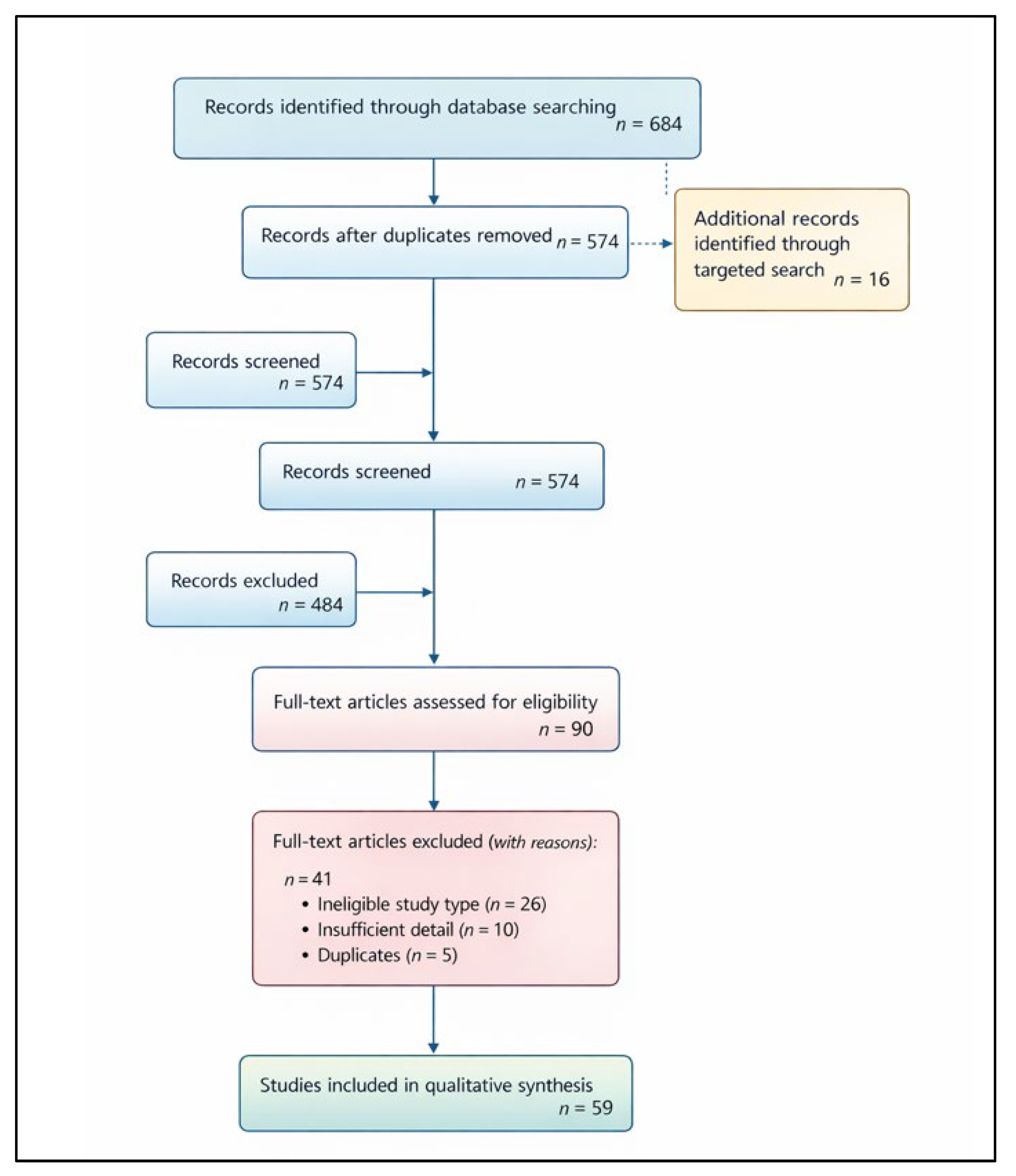
Figure 2.
Integrated systems framework linking UAV sensing, AI analytics and climate-smart agriculture.
Figure 2.
Integrated systems framework linking UAV sensing, AI analytics and climate-smart agriculture.
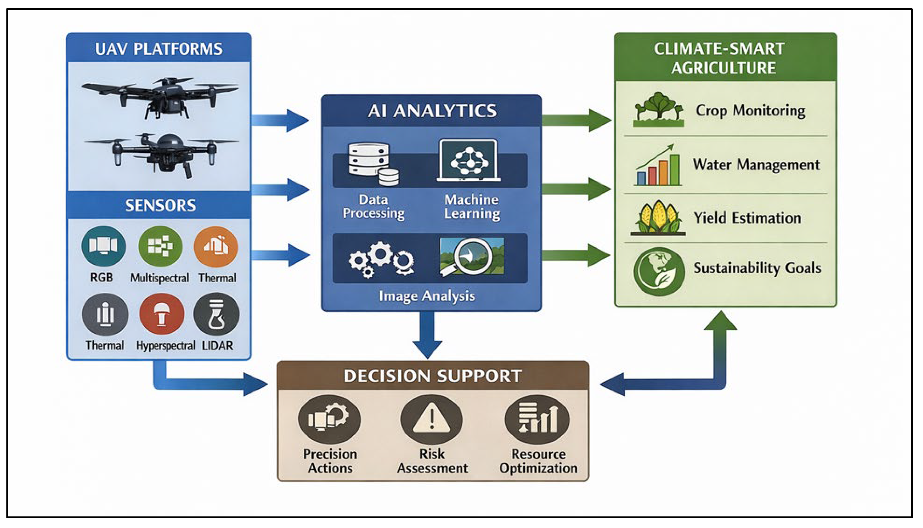
Figure 3.
UAV platform typology and operational characteristics across spatial and endurance gradients.
Figure 3.
UAV platform typology and operational characteristics across spatial and endurance gradients.
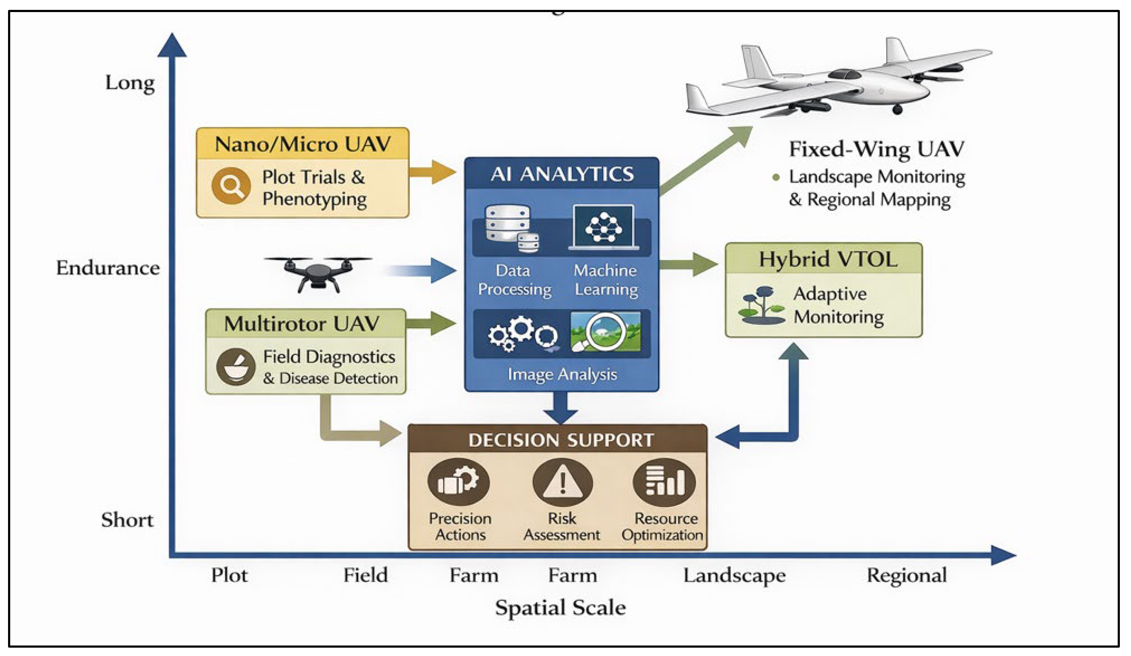
Figure 4.
Multisensor acquisition and analytical performance matrix for UAV-based crop diagnostics.
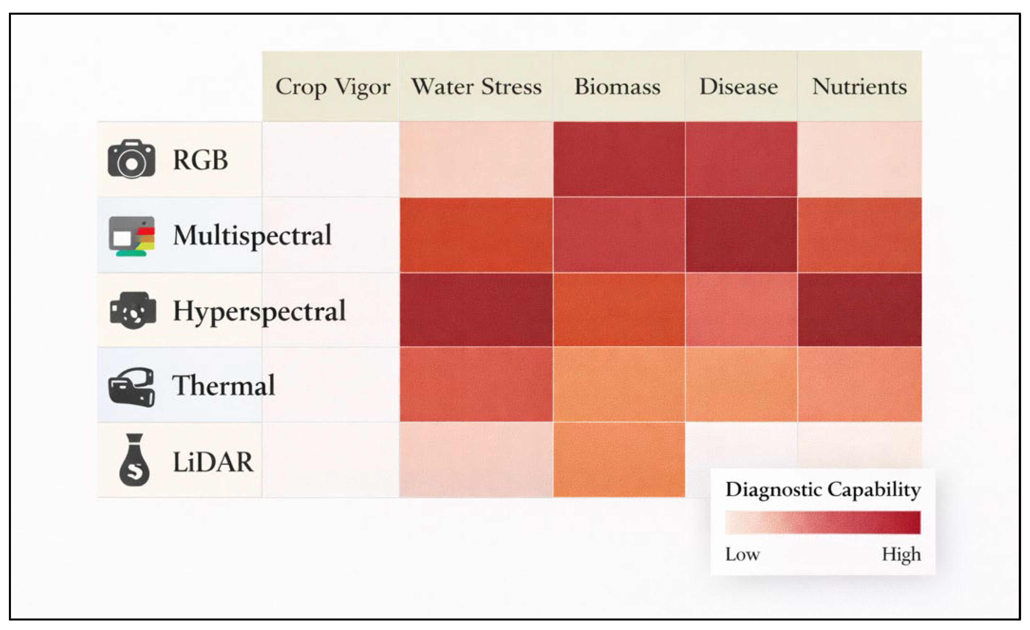
Figure 5.
UAV–AI analytical pipeline for agricultural diagnostics and predictive decision support.
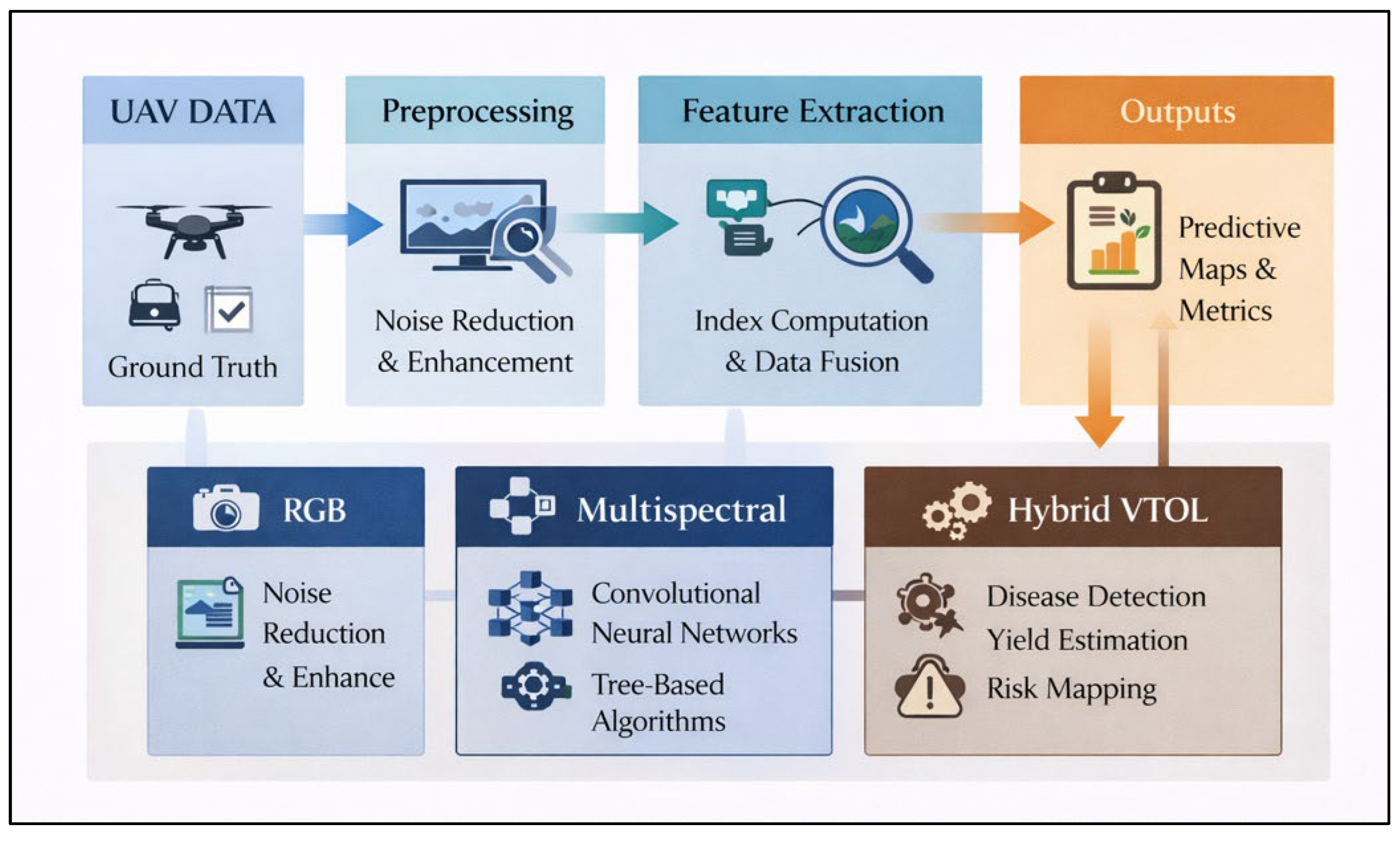
Figure 6.
Conceptual framework linking UAV-based sensing and AI analytics to productivity, adaptation, and mitigation diagnostics within climate-smart agricultural systems.
Figure 6.
Conceptual framework linking UAV-based sensing and AI analytics to productivity, adaptation, and mitigation diagnostics within climate-smart agricultural systems.
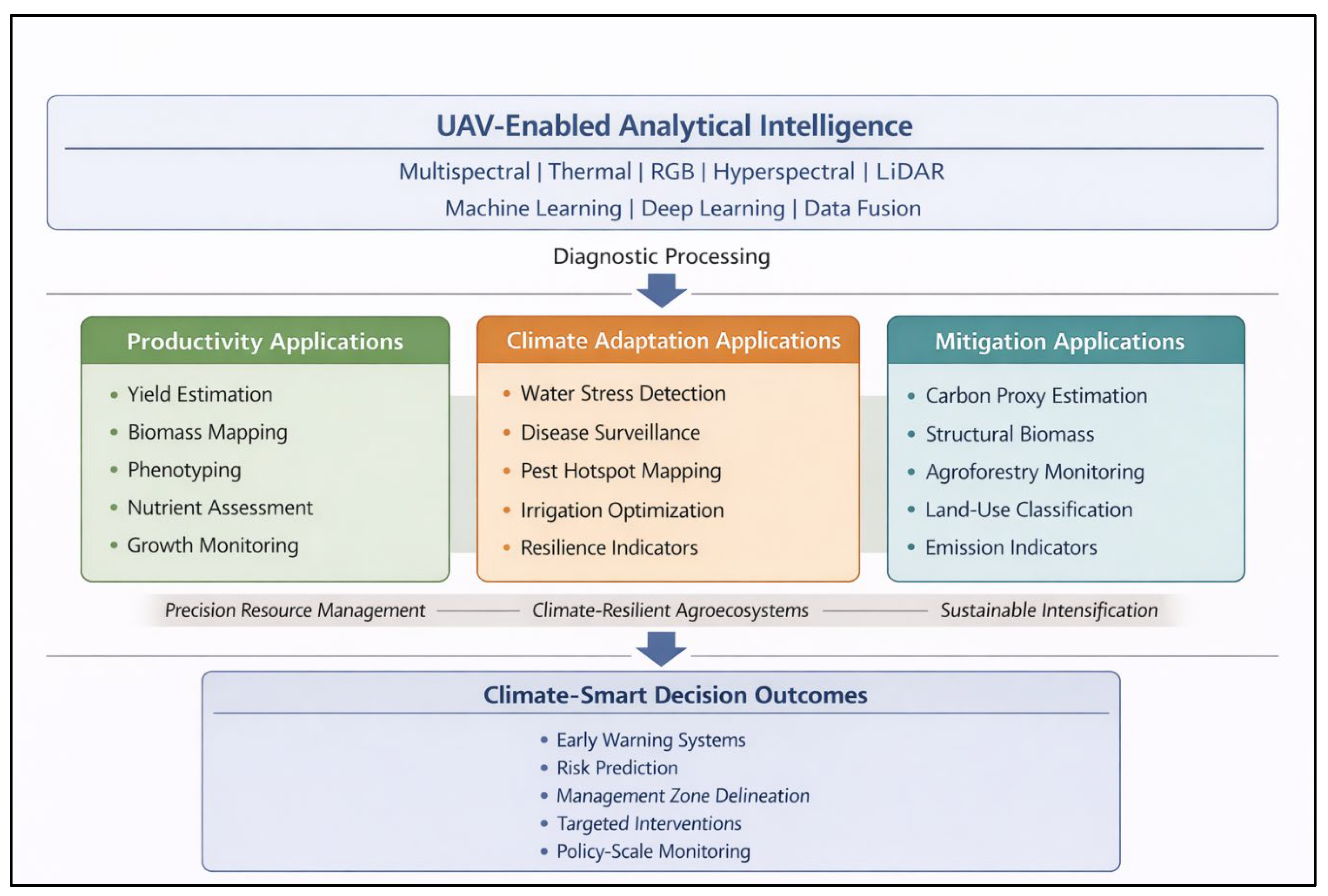
Figure 7.
Comparative deployment and service-delivery models for UAV-enabled climate-smart agricultural systems, illustrating pathways from data acquisition and integration to advisory dissemination and farmer-level decision support across institutional configurations.
Figure 7.
Comparative deployment and service-delivery models for UAV-enabled climate-smart agricultural systems, illustrating pathways from data acquisition and integration to advisory dissemination and farmer-level decision support across institutional configurations.
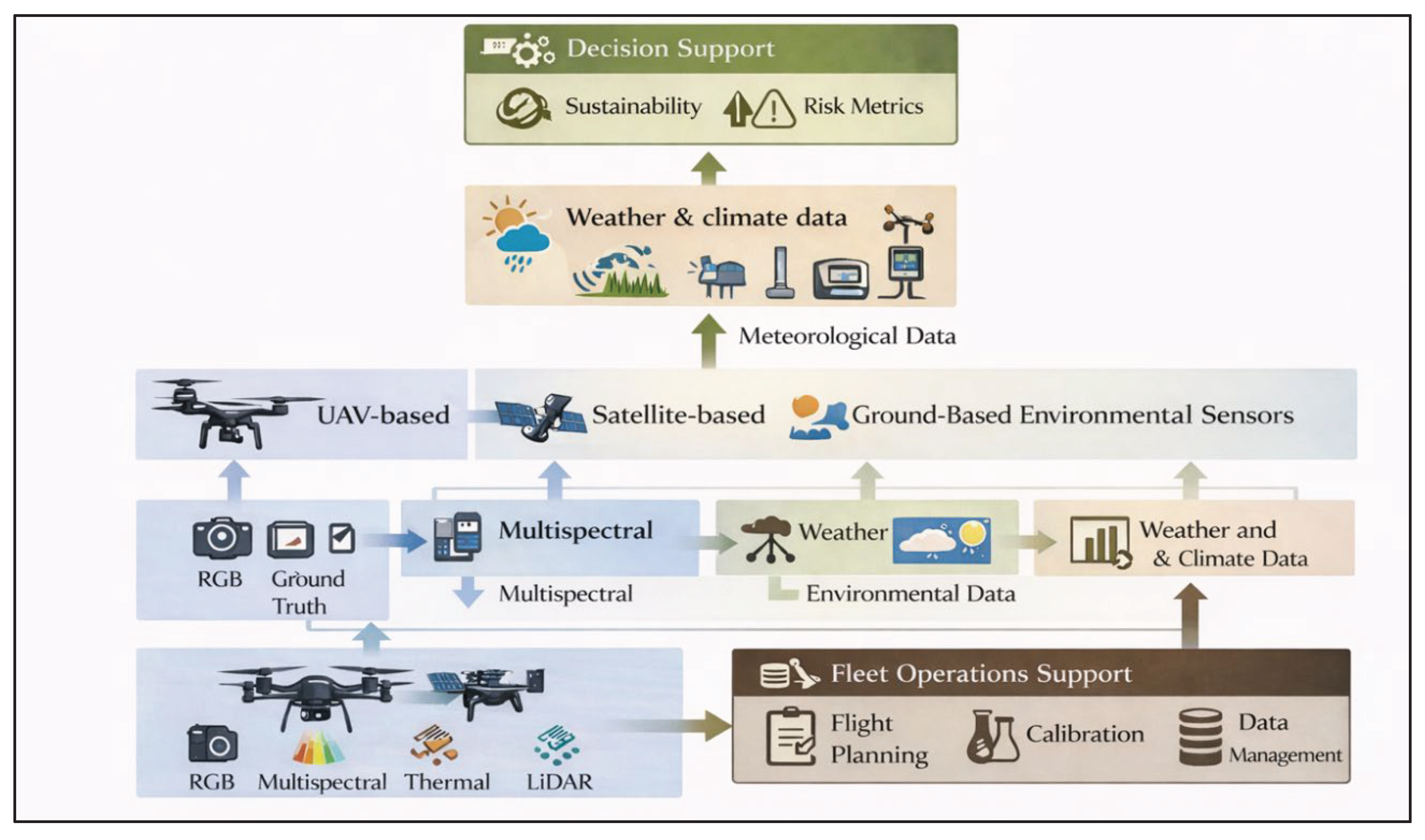
Table 2.
Comparative characteristics of UAV sensor modalities including diagnostic outputs and climate-smart agriculture (CSA) relevance.
Table 2.
Comparative characteristics of UAV sensor modalities including diagnostic outputs and climate-smart agriculture (CSA) relevance.
| Sensor Type | Primary Data | Typical Outputs | Strength | Limitation | CSA Relevance |
|---|---|---|---|---|---|
| RGB | Visible imagery | Stand count; canopy cover | High spatial detail | Limited physiological sensitivity | Productivity |
| Multispectral | Narrow spectral bands | NDVI; chlorophyll | Balanced cost–performance | Moderate spectral resolution | Productivity + Adaptation |
| Hyperspectral | Continuous spectra | Nutrients; disease | Biochemical sensitivity | High processing demand | Productivity + Adaptation |
| Thermal | Temperature | Water stress | Early stress detection | Atmosphere sensitive | Adaptation |
| LiDAR | 3D structure | Biomass; canopy height | Structural accuracy | Expensive | Mitigation + Productivity |
Table 3.
Major AI/ML analytical architectures used in UAV-based agricultural diagnostics.
| Algorithm Class | Representative Models | Primary Applications | Strength |
|---|---|---|---|
| Classical ML | Random Forest (RF); Support Vector Machine (SVM); Gradient Boosting (GBM) | Yield prediction; crop classification; stress detection | Robust with small and heterogeneous datasets |
| Deep Learning | Convolutional Neural Networks (CNN); U-Net | Disease detection; image segmentation; lodging detection | Automatic feature extraction; strong spatial pattern recognition |
| Regression | Partial Least Squares Regression (PLSR) | Nutrient estimation; biophysical parameter retrieval | Interpretable relationships between spectra and traits |
| Hybrid | ML + crop/physiological models | Forecasting; parameter retrieval; cross-site prediction | Improved interpretability and generalizability |
| Ensemble | Stacking; Boosting; Meta-learning | Multi-output prediction; yield + stress combined modeling | High predictive accuracy; reduced single-model bias |
Table 4.
Multisource data fusion architectures in UAV-enabled agricultural monitoring systems.
| Fusion Level | Integration Strategy | Example Data Streams | Analytical Advantage |
|---|---|---|---|
| Feature-level fusion | Raw or extracted features combined prior to model training | UAV spectral indices + satellite NDVI + soil moisture sensors | Exploits complementary signals; improves model input richness |
| Model-level fusion | Independently trained models combined through ensemble or meta-learning | UAV yield model + climate risk model + soil fertility model | Enhances robustness; reduces single-model bias |
| Decision-level fusion | Independent model outputs synthesized at interpretation stage | UAV stress alert + rainfall anomaly forecast + extension advisory | Improves decision relevance and operational clarity |
| Temporal fusion | Multi-date or time-series integration across growth stages | Repeated UAV flights + seasonal climate data | Captures phenological dynamics; improves forecasting stability |
| Cross-scale fusion | Fine-resolution UAV data integrated with broader landscape datasets | Plot-level UAV imagery + regional satellite observations | Extends local diagnostics to landscape and regional scales |
Table 5.
Machine-learning applications in UAV-based agricultural diagnostics and CSA alignment.
| Application | Typical Outputs | CSA Pillar(s) | Decision-Support Value |
|---|---|---|---|
| Yield estimation | Spatial yield maps; productivity forecasts | Productivity | Resource allocation; market forecasting |
| Stress detection | Water and nutrient stress indices | Adaptation | Early intervention; irrigation adjustment |
| Disease detection | Lesion maps; infection probability | Adaptation | Targeted treatment; reduced pesticide use |
| Biomass mapping | Carbon proxies; canopy volume | Mitigation | Carbon accounting; sustainability monitoring |
| Phenotyping | Trait metrics; growth rate indicators | Productivity | Breeding selection; performance benchmarking |
| Nutrient deficiency detection | Chlorophyll proxies; nutrient maps | Productivity + Adaptation | Precision fertilization |
| Crop classification | Field-level crop maps | Productivity | Planning and logistics |
Table 6.
Figure 6. Integrated framework illustrating how UAV-enabled analytical intelligence supports productivity enhancement, climate adaptation, and mitigation outcomes within climate-smart agricultural systems.
Table 6.
Figure 6. Integrated framework illustrating how UAV-enabled analytical intelligence supports productivity enhancement, climate adaptation, and mitigation outcomes within climate-smart agricultural systems.
| Constraint Category | Primary Source | Impact on Scalability/Deployment | Mitigation Strategy |
|---|---|---|---|
| Limited flight endurance | Battery capacity | Reduced coverage; high per-hectare cost | Coordinated flight planning; fixed-wing platforms; shared service models |
| Sensor variability | Calibration drift; lighting differences | Inconsistent measurements across seasons or sites | Standard calibration protocols; reflectance panels; radiometric correction |
| Weather sensitivity | Wind, cloud cover, humidity | Data noise; scheduling uncertainty | Flexible scheduling; correction algorithms; local weather monitoring |
| Data processing burden | Large data volumes; limited local computing | Delayed analysis; limited local ownership | Cloud-based platforms; decentralized processing hubs |
| Ground-truth limitations | Sparse field measurements | Model bias; reduced transferability | Stratified sampling; seasonal validation |
| Financial constraints | High equipment and maintenance cost | Limited adoption among smallholders | Cooperative drone services; subsidy models; youth drone hubs |
| Regulatory barriers | Airspace restrictions; licensing requirements | Restricted deployment; operational delays | Regulatory harmonization; certified operator training |
| Digital capacity gaps | Limited technical skills | Underutilization of analytical outputs | Capacity building; extension integration; digital literacy programs |
Table 7.
Comparative deployment models for UAV-enabled agricultural monitoring systems, including operational characteristics and suitability contexts.
Table 7.
Comparative deployment models for UAV-enabled agricultural monitoring systems, including operational characteristics and suitability contexts.
| Deployment Model | Primary Operator | Core Strength | Principal Limitation | Most Suitable Context |
|---|---|---|---|---|
| Research-led | Universities/research institutes | Methodological rigor; experimental control; innovation testing | Limited scalability; project-based funding | Pilot studies; experimental trials; technology validation |
| Private-sector | Commercial UAV service providers | Operational efficiency; rapid deployment; technical specialization | High service costs; profit-driven focus | Commercial farms; export-oriented agriculture |
| Cooperative model | Farmer associations/producer groups | Shared cost structure; local accessibility; community ownership | Coordination challenges; limited technical capacity | Smallholder clusters; participatory monitoring |
| Public–private partnership (PPP) | Government + private operators | Scalable infrastructure; institutional legitimacy; policy alignment | Administrative complexity; slower implementation cycles | National monitoring programs; subsidy-linked services |
| Digital youth hubs | Local technology centers; trained youth operators | Local employment; rapid response; contextual knowledge | Requires sustained training and support | Rural districts; decentralized service provision |
Disclaimer/Publisher’s Note: The statements, opinions and data contained in all publications are solely those of the individual author(s) and contributor(s) and not of MDPI and/or the editor(s). MDPI and/or the editor(s) disclaim responsibility for any injury to people or property resulting from any ideas, methods, instructions or products referred to in the content. |
© 2026 by the authors. Licensee MDPI, Basel, Switzerland. This article is an open access article distributed under the terms and conditions of the Creative Commons Attribution (CC BY) license.
Copyright: This open access article is published under a Creative Commons CC BY 4.0 license, which permit the free download, distribution, and reuse, provided that the author and preprint are cited in any reuse.