Submitted:
25 February 2026
Posted:
26 February 2026
You are already at the latest version
Abstract
Urban renewal, driven by investments in urban space, has transformed the urban landscape and significantly impacted changes in land use and the physical appearance of the urban environment. Incorporating GOS to change the appearance of cities is an important strategy for urban development, by utilizing them as central points of building orientation. Changes in the land use of GOS into other functions that have a negative impact on the urban environment have been widely studied by researchers, but not much research has been done on changes in land use around GOS which function as the central point of urban orientation. This research will examine changes in land use patterns around the Karebosi Field Complex GOS on a building plot unit scale using a survey research approach with descriptive analysis. The research was conducted in Makassar City, and data analysis was carried out in 2023. The GOS sample was selected through purposive sampling, the Karebosi Field Complex GOS was deliberately chosen as the research subject because of its area and optimal and dynamic activities, as a leading landmark that contributes to Makassar city branding. It was found that changes in land use based on building plot units, some of which have taken place three times, 89 percent of the land plots around GOS have changed function, all land function changes have become land with commercial functions, the two land plot units that have not changed function are Makassar District Court Office and Church Building. Centrifugal force occurs when government building land is pushed away from the city core and replaced by commercial building land as a manifestation of centripetal force which is attracted to enter the city core area and function as a central business district.
Keywords:
land use change
; green open space
; urban renewal
; centrifugal and centripetal force
; city
1. Introduction
Cities have experienced multidimensional growth since the 20th century due to both local and global dynamics (Bruzzone & Utgés, 2022; Dey et al., 2021). This growth has also led to the rapid evolution of urban development, resulting in consequential land use changes and urban land fragmentation (Nath, 2020). Modern planning and management of urban space is needed to ensure sustainable and compact development of cities (Artmann et al., 2019). Achieving this goal requires the implementation of global and local policies that lead to positive economic, environmental, and social outcomes, all of which contribute to urban sustainability (Bibri, 2020).
Urban renewal, driven by investments in urban spaces, is a manifestation of the evolving urban landscape of cities with significant implications for land use and the physical appearance of the urban environment (Abed, 2020; Abuzayed & Al-Kurdi, 2019). Such developments are primarily driven by economic considerations, reflecting an increasing trend of urban growth. Abbreviations of technical terms used in this text will be explained the first time they are used. Green spaces are used to change the appearance of urban areas and provide competitive, revised, and diversified models for urban development (Lak, 2020). City residents participate in this strategy (Chen, 2020; Arnstein, 2019), taking into account the age factor (Cheng, 2019), gentrification (Schnake-Mahl, 2020), ecological function optimization (R. Guo, 2019), and violence reduction (Moyer, 2019).
Visually, the grouping of study topics, as shown in Figure 1, shows the density of study topics, which is represented by the size of the circle surrounding the topic. The larger the circle indicates that this topic has been studied by many researchers, and if the circle is small, it means that the topic still has limited research. discussed, which allows research to be conducted as a future study to obtain new findings related to this topic. In Figure 1, you can see the changes in land use represented by the small circle in the lower right corner.
The details of the 11 classes of studies on cities and green open spaces as well as changes in land use are shown in Table 1.
Changes in land function around strategic locations in cities is an urban phenomenon that occurs throughout the world and is the subject of study by urban researchers. The use of physical theories to explain phenomena that occur in urban areas, especially those related to land use changes such as centrifugal and centripetal theories. Centrifugal in urban phenomena is described as a force that attracts residents to the city center, while centripetal is described as a force that pushes residents out of the city center (Growe & Volgmann, 2022), (Dadashpoor & Ahani, 2021), (Schad et al., 2019), (Colby, 2009).
Urban studies from a different perspective see the process of changing land functions in strategic areas of the city as urban regeneration (Lak, 2020), (Senosiain, 2020), (Agirbas, 2020), (Furlan, 2019), which can be implemented in various forms as urban land revitalization. Studies on urban land revitalization in various literature are often presented in different terms, including urban revitalization (Ibrahim, 2023), (Prener, 2020), (Dollah, A.S., et al., 2023), (Y. Li, 2019), (Y. Wang et al., 2018), urban renewal (Rius-Ulldemolins, 2022), (Siwi, 2021), (M. Wang, 2021), urban gentrification (Schnake-Mahl, 2020), (Ehrenfeucht, 2020), (DIllon , 2019), which in its current development includes environmental elements as one of the main considerations in its implementation (Y. Guo, 2020), (Smith, 2020), (J. Li, 2021).
Urban renewal is a manifestation of the development of the lives of city residents, which has experienced an increase, especially from the economic aspect, which is based on investment in urban spaces and has implications for changing the appearance of the city, both in terms of land use and physical appearance (Abed, 2020), (Abuzayed & Al-Kurdi, 2019). The expansion of green open space as an orientation for changing the appearance of the city is one of the strategies in urban development through competitive, revision and diversification models (Lak, 2020), involving the participation of city residents (Chen, 2020), (Arnstein, 2019), paying attention to age factors (Cheng , 2019), gentrification (Schnake-Mahl, 2020), optimizing the ecological function of the area (R. Guo, 2019), and reducing the impact of violence (Moyer, 2019). Green open space is also an urban element that can act as a catalyst to stimulate life in new urban areas and then influence the form, character, and quality of subsequent urban elements where a catalytic chain reaction can occur.
The various processes of urban development that continue to grow, raise the central point of business development in the city center as a result of the concentration of orientation in strategic areas, which is also influenced by the development of globalization (Commission & European, 2018). This creates an area with a concentration of economic growth, physical buildings, and rapid land use changes in the area, with a high level of easily accessible infrastructure (Growe & Volgmann, 2022). This process will also make the value of land in this area expensive (Okamoto & Sato, 2021), so the utilization is maximized through vertical development up and down. Additionally, the distribution of land plot size will be in the form of blocks.
Karebosi Field complex green open space, which is the largest green open space in the city of Makassar (Dollah et al., 2014), (Mahsyar, 2015), (Aidina et al., 2020), with a position at the zero kilometer point and is one of the landmarks of the city of Makassar. easily recognized as city branding (Garcia-Lamarca, 2021), (Lak, 2020), (Molinillo, 2019), (Siregar, 2019), or as a landmark that forms a city image (Hussein, 2020), (Miftahuddin, 2020), (Priporas, 2020), (Filomena, 2019), (Mondschein & Moga, 2018), (Lynch, 1960). Due to its very strategic location as the center of the city, it has become a point of orientation for various urban activities, especially those related to public services and business. This condition makes the surrounding urban land a target for capital owners to locate there.
The green open space of the Karebosi Field complex and its surroundings is the core area of the city, in the development of urban studies it is known as the Central Business District (CBD) area of Makassar City. The central urban commercial area is often considered as the heart of the city (Yang et al., 2019), or the center of the city’s economic and social network that contains a concentration of commercial land uses (Drozdz et al., 2012), (Murphy & Vance, 1954). This understanding is also inseparable from rapid economic development and urbanization, which pose urban challenges in the form of limited public resources that promote a shift in the concentration of urban functions from monocentric to polycentric structures and tend to generate more complex urban environments (Huai et al., 2021 ), (Fosgerau et al., 2018), (Garcia-López & Moreno-Monroy, 2018).
This research examines the changes in land function that occur around the green open space at the Karebosi Field Complex on the four sides of the surrounding road, namely Jalan Jenderal Sudirman on the east side, which in this case is categorized as Area A, Jalan R.A. Kartini on the south side as Area B, Jalan Kajaolaliddo on the west side as Area C, and Jalan Jenderal Ahmad Yani on the north side as Area D, with an observation period from the early 20th century to 2022. The location of the research object is shown in Figure 2.
2. Research Significance and Objectives
The importance of this research is to provide an understanding of the pattern of changes in land use at the plot scale around the green open space, which is located in the city center and also as the central business district, especially land that uses green open space as an orientation point. Green open space as an urban space with various interesting functions, is a place that is always busy with city residents for various purposes, it can be in the form of recreation, a meeting place for various social activities (Assefa et al., 2021), (Berglihn & Gómez-Baggethun, 2021), (Palliwoda, 2020), (Manikasari, 2019), (Bratman et al., 2019), (Bartesaghi-Koc, 2019), (Ignatieva, 2020), (Venter et al., 2020), as a transit or transition place that provides orientation to the next destination around it. Architecturally, open space as an open space can be a building orientation that makes the appearance of the building more majestic and monumental. Because this strategic function and location attracts other functions to approach it, resulting in changes in land use. Different land functions occur around the GOS, including office functions, shopping functions, social functions such as hospitals, education, and various other functions. Likewise, in terms of building floor patterns, five floors above or below five floors.
The aim of this research is to examine trends in land use change patterns at the parcel scale around the dominant green open space. So far, research on green open spaces is related to the change of function of green open spaces to other functions that have a negative impact on the urban environment. Thus, this research provides an understanding of the pattern of land use change around green open spaces at a smaller plot scale to be used as material for policy making for urban development, especially in the city center area with green open spaces as the center of orientation.
3. Methodology
This research is a survey research with descriptive analysis. The research location is in Makassar City, and data analysis was conducted in 2023. Determination of the GOS sample was carried out using a purposive sampling technique (Campbell, 2020), (Andrade, 2021), (Kissi, 2020), for this reason, the Karebosi Field Complex GOS was deliberately chosen as the object of research, because this GOS is the most extensive and strategic, the most dynamic activity, is located in the central business district area and as a landmark or city branding of the city of Makassar. Observation of land use change from the early 20th century to 2022. Data was collected using observation techniques through direct observation of researchers in the field, as well as through maps via Google search, as well as maps of the city of Makassar, especially around GOS Karebosi Field at relevant city agencies. The map overlap technique was used to determine the location and changes of the observed plots (Martins, 2020), (Rane et al., 2023), (Thinh et al., 2023). Interviews were also conducted with resource persons knowledgeable about the land conditions around the Karebosi field complex. Data documentation was carried out in the form of recordings and photographs. In addition, a literature review was conducted as a normative reference and a basis for theoretical analysis, especially those related to land use change and urban green open space.
4. Overview of Research Locations
According to the page https://daenggassing.com, accessed in September 2023, Karebosi Field, or Koningsplein in Dutch, was at that time part of the firing training grounds for Dutch soldiers, both infantry and artillery. This place is located east of Fort Rotterdam, which was the center of residence and defense for the Dutch troops when they succeeded in conquering the Kingdom of Gowa as the ruler of the region at that time.
After the security conditions could be controlled, the Dutch government began to develop the embryonic expansion of the city of Makassar by developing the Karebosi area and its surroundings following the urban planning pattern of European countries in general with the Axis Style concept and city parks (Dollah, 2023). Several buildings were built, including the Prison Building and Court Building on the north side, the Immanuel Protestant Church and Hotel were built on the west side, the Raad van Justitie was built on the south side, now the Court House, and the Vredenburg Fortress was built on the east side, connected to the hospital, now known as Pelamonia Hospital. Apart from that, several parks were also built, which represent the characteristics of developing cities in the Netherlands and its surroundings, which are happy with parks. Most of this land has changed drastically in function. The picture is shown in Figure 3.
5. Research Results
In general, the process of land use change around the green open space of Makassar Karebosi Field Complex from the early 20th century to 2022 is as shown in Table 2.
It can be seen in Area A or on the east side of the Karebosi Field Complex, which used to be the site of Fort Vredenburg and has now changed its function to offices and education. If you look more closely from north to south, from Jalan Jenderal Muhammad Yusuf to Jalan Gunung Bawakaraeng, you can see the Bank Negara Indonesia building, the Makassar Regional Representative Bank Indonesia building, the Bosowa Tower Rental Office, a primary school and an insurance office. Specifically for the land occupied by the Bosowa Tower, there was previously a laboratory building, so the land function has changed three times, while the other land has changed only twice, namely the transition from fortress land to offices and educational buildings. The process of land function change that occurs in area A is a process of concentration of commercial functions that are attracted to the city core, which is known as the centripetal effect (Growe & Volgmann, 2022). Visually as seen in Figure 4.
In Area B or on the south side of the Karebosi Field Complex from east to west, except for the Makassar District Court Building which was previously known as Raad Van Jastitie Building, apart from that, it was an elite residential building in its time. The current condition of some of these houses has changed its function to Bank Mandiri, Siti Chadijah Maternity Home, while the Kartini Maternity Home which is located in the west corner, the condition of the land has not changed from the basic form of housing, only in some parts it has been modified to become a maternity hospital.
In this area, there are two areas where fundamental changes in land function have occurred, namely the Bank Mandiri land and the Siti Chadijah Maternity Hospital land. Pictorially as seen in Figure 5.
In area C, or the west side, there were church and hotel buildings at the beginning of the 19th century. In the current conditions, if you look from south to north, the land for the church building is still as before, then the land for the school building, then the land for bank offices, and then the land for shop buildings. The change in land function that occurred here was in the school building, where the building previously stood for the office of the commander of the Indonesian Air Force for the Sulawesi region, so there has been a change in land use three times since the beginning of the 19th century, while for the others only twice. In changing the function of the land from the air force commander’s office to land for school buildings, centrifugal forces are at work here, with the air force commander’s office being pushed out to the east of the city toward Sultan Hasanuddin Airport, which is also a fighter base. The visual land use conditions in Area C are shown in Figure 6.
In area D, changes in land use have occurred since the early 19th century, where previously stood the prison building and court building, now the land has changed its function to become a multi-story shopping center, meaning more than four floors, and rows of shops. two-story shop. On the land where the multi-story shopping center now stands, land use has changed, starting from the early 19th century in the form of the Prison Building and Court Building complex, then changed to a Lung Hospital and now a shopping center, then the land to the west of the shopping center is in the form of a row of shops, the changes that occurred from the Prison Building and Court Building to become the Commander’s Headquarters of the XIV Hasanuddin Regional Military Command and then to a row of shops. The change in land use of the Lung Hospital into a shopping mall and the Commander’s Headquarters of Kodam XIV Hasanuddin into a row of shops is a change as explained by the centrifugal theory, where these two buildings are pushed out of the city core. Visually, the current land conditions in Area D are as shown in Figure 7.
6. Conclusion
The ratio of land that has changed function to land that has not changed function based on the observed land is 2:18, which means that 89 percent of the land around the GOS has changed function. The two plots that have not changed function are the Makassar District Court Office and the church building.
All changes in land use will lead to commercial use, and the use of every inch of land will be optimized through multi-story buildings and the use of underground areas. Connectivity between plots of land under the same management will begin to be implemented with underground connecting lines running under the city’s main roads.
The centrifugal effect generally occurs in government-owned buildings that are pushed away from the urban core, while the centripetal effect is the attraction of commercial buildings to the area around the GOS.
Further research with a broader scope is needed to gain a more comprehensive understanding, especially of the CBD area around GOS Karebosi.
Author Contributions
Conceptualization, ASD.; Data curation, ASD. and MM; Methodology, ASD.; Resources, M.M.; Validation, AMJ; Writing, review, and editing, ASD.; Visualization, ASD. and MM-English translation and editing, AMJ; All authors read and approved the submitted version of the manuscript.
Funding
This research received no external funding.
Conflicts of Interest
The authors declare no conflict of interest.
References
- Abed, A. Brownfield Regeneration as a Strategy for Sustainable Development: Amman Case Study. International Journal of Technology 2020, 11(4), 732–742. [Google Scholar] [CrossRef]
- Abuzayed, A.; Al-Kurdi, N. Transforming Brownfields from Deteriorated to Revitalized Space – The Role of Local Urban Community. Journal of Ecological Engineering 2019, 20(8), 18–34. [Google Scholar] [CrossRef]
- Agirbas, A. Characteristics of social formations and space syntax application to quantify spatial configurations of urban regeneration in Levent, Istanbul. Journal of Housing and the Built Environment 2020, 35(1), 171–189. [Google Scholar] [CrossRef]
- Aidina, A. I.; Najamuddin, N.; Malihu, L. Lapangan Karebosi Kota Makassar 1990-2017. Attoriolong 2020, 18(2). Available online: https://scholar.google.com/citations?view_op=view_citation&hl=en&user=jP9sLqgAAAAJ&pagesize=100&citation_for_view=jP9sLqgAAAAJ:i2xiXl-Tujo.
- Arnstein, S. R. A Ladder of Citizen Participation. Journal of the American Planning Association 2019, 85(1), 24–34. [Google Scholar] [CrossRef]
- Artmann, M.; Inostroza, L.; Fan, P. Urban sprawl, compact urban development and green cities. How much do we know, how much do we agree? Ecological Indicators 2019, 96, 3–9. [Google Scholar] [CrossRef]
- Assefa, W. W.; Eneyew, B. G.; Wondie, A. The impacts of land-use and land-cover change on wetland ecosystem service values in peri-urban and urban area of Bahir Dar City, Upper Blue Nile Basin, Northwestern Ethiopia. Ecological Processes 2021, 10(1). [Google Scholar] [CrossRef]
- Bartesaghi-Koc, C. Mapping and classifying green infrastructure typologies for climate-related studies based on remote sensing data. Urban Forestry and Urban Greening 2019, 37, 154–167. [Google Scholar] [CrossRef]
- Berglihn, E. C.; Gómez-Baggethun, E. Ecosystem services from urban forests: The case of Oslomarka, Norway. Ecosystem Services 2021, 51, 101358. [Google Scholar] [CrossRef]
- Bibri, S. E. Compact city planning and development: Emerging practices and strategies for achieving the goals of sustainability. Developments in the Built Environment 2020, 4. [Google Scholar] [CrossRef]
- Bratman, G. N.; Anderson, C. B.; Berman, M. G.; Cochran, B.; de Vries, S.; Flanders, J.; Folke, C.; Frumkin, H.; Gross, J. J.; Hartig, T.; Kahn, P. H.; Kuo, M.; Lawler, J. J.; Levin, P. S.; Lindahl, T.; Meyer-Lindenberg, A.; Mitchell, R.; Ouyang, Z.; Roe, J.; Daily, G. C. Nature and mental health: An ecosystem service perspective. Science Advances 2019, 5(7). [Google Scholar] [CrossRef]
- Bruzzone, O. A.; Utgés, M. E. Analysis of the invasion of a city by Aedes aegypti via mathematical models and Bayesian statistics. Theoretical Ecology 2022, 15(1), 65–80. [Google Scholar] [CrossRef]
- Chen, Y. Emerging Participative Approaches for Urban Regeneration in Chinese Megacities. Journal of Urban Planning and Development 2020, 146(1). [Google Scholar] [CrossRef]
- Cheng, L. Active travel for active ageing in China: The role of built environment. Journal of Transport Geography 2019, 76, 142–152. [Google Scholar] [CrossRef]
- Colby, C. C. Centrifugal and Centripetal Forces in Urban Geography. Annals of the Association of American Geographers 2009, 23(1), 1–20. Available online: https://www.tandfonline.com/doi/abs/10.1080/00045603309357110?journalCode=raag20. [CrossRef]
- Commission, I. G. U.; European, A.; Pumain, D.; Rozenblat, C. Two metropolisation gradients in the European system of cities revealed by scaling laws. Environment and Planning B: Urban Analytics 2018, 1–23. [Google Scholar]
- Dadashpoor, H.; Ahani, S. Explaining objective forces, driving forces, and causal mechanisms affecting the formation and expansion of the peri-urban areas: A critical realism approach. Land Use Policy 2021, 102, 105232. [Google Scholar] [CrossRef]
- Dey, N. N.; Al Rakib, A.; Al Kafy, A.-; Raikwar, V. Geospatial modelling of changes in land use/land cover dynamics using Multi-layer Perceptron Markov chain model in Rajshahi City, Bangladesh. Environmental Challenges 2021, 4, 100148. [Google Scholar] [CrossRef]
- DIllon, D. Developer-led gentrification and legacies of urban policy failure in Post-Riot Tottenham. Community Development Journal 2019, Vol. 54(Issue 4), 605–621. [Google Scholar] [CrossRef]
- Dollah, A.S.; Mustafa Mursyid, A.M.J. Ecological Potential Analysis of Green Open Space (GOS) for the Karebos Field Complex Before and After Revitalization. IJSER 2023, 14(1), 693–713. [Google Scholar] [CrossRef]
- Dollah, A. S. The social performance of the Green Open Space (GOS) in Karebosi Field Complex. Social Sciences and Humanities Open 2023, 8(1). [Google Scholar] [CrossRef]
- Dollah, A. S.; Ardi, M.; Mulyadi; Pertiwi, N.; Dirawan, G.D. Distribution analysis of green open space in Makassar. International Journal of Academic Research 2014, 6(4), 103–110. [Google Scholar] [CrossRef]
- Drozdz, M.; Appert, M.; Drozdz, M.; Appert, M.; Cbd, R. Re-understanding CBD: a landscape perspective To cite this version: HAL Id: halshs-00710644. 0–11 2012.
- Ehrenfeucht, R. Just revitalization in shrinking and shrunken cities? Observations on gentrification from New Orleans and Cincinnati. Journal of Urban Affairs 2020, 42(3), 435–449. [Google Scholar] [CrossRef]
- Filomena, G. A computational approach to ‘The Image of the City. Cities 2019, 89, 14–25. [Google Scholar] [CrossRef]
- Fosgerau, M.; Kim, J.; Ranjan, A. Vickrey meets Alonso: Commute scheduling and congestion in a monocentric city. Journal of Urban Economics 2018, 105, 40–53. [Google Scholar] [CrossRef]
- Furlan, R. The urban regeneration of west-bay, business district of Doha (State of Qatar): A transit-oriented development enhancing livability. Journal of Urban Management 2019, 8(1), 126–144. [Google Scholar] [CrossRef]
- Garcia-Lamarca, M. Urban green boosterism and city affordability: For whom is the ‘branded’ green city? Urban Studies 2021, 58(1), 90–112. [Google Scholar] [CrossRef]
- Garcia-López, M.-À.; Moreno-Monroy, A. I. Income segregation in monocentric and polycentric cities: Does urban form really matter? Regional Science and Urban Economics 2018, 71, 62–79. [Google Scholar] [CrossRef]
- Growe, A.; Volgmann, K. Metropolisation through Regionalisation? Spatial Scope and Anchor Points of Metropolitan Functions in German Urban Regions. Tijdschrift Voor Economische En Sociale Geografie 2022, 113(5), 502–522. [Google Scholar] [CrossRef]
- Guo, R. The construction and optimization of ecological security pattern in the Harbin-Changchun urban agglomeration, China. International Journal of Environmental Research and Public Health 2019, 16(7). [Google Scholar] [CrossRef]
- Guo, Y. The effect of industrial agglomeration on green development efficiency in Northeast China since the revitalization. Journal of Cleaner Production 2020, 258. [Google Scholar] [CrossRef]
- Huai, Y.; Lo, H. K.; Ng, K. F. Monocentric versus polycentric urban structure: Case study in Hong Kong. Transportation Research Part A: Policy and Practice 2021, 151, 99–118. [Google Scholar] [CrossRef]
- Hussein, A. S. City branding and urban tourist revisit intention: The mediation role of city image and visitor satisfaction. International Journal of Tourism Policy 2020, 10(3), 262–279. [Google Scholar] [CrossRef]
- Ibrahim, Z. O. Towards Sustainable Revitalization: The Public Squares Characteristics-Led the Adaptive Urban Revitalization Mechanisms. Civil Engineering Journal (Iran) 2023, 9(4), 960–973. [Google Scholar] [CrossRef]
- Ignatieva, M. Lawns in cities: From a globalised urban green space phenomenon to sustainable nature-based solutions. Land 2020, 9(3). [Google Scholar] [CrossRef]
- Kholifah, N. Benteng Ujung Pandang Cikal Bakal Kota Makassar ( Sebuah Kajian Lanskap Konflik, Sosial Budaya dan Alam ); 2002. [Google Scholar]
- Lak, A. Urban regeneration through heritage tourism: cultural policies and strategic management. Journal of Tourism and Cultural Change 2020, 18(4), 386–403. [Google Scholar] [CrossRef]
- Li, J. County-rural revitalization spatial differences and model optimization in Miyun District of Beijing-Tianjin-Hebei region. Journal of Rural Studies 2021, 86, 724–734. [Google Scholar] [CrossRef]
- Li, Y. Why some rural areas decline while some others not: An overview of rural evolution in the world. Journal of Rural Studies 2019, 68, 135–143. [Google Scholar] [CrossRef]
- Lynch, K. Chapter Two Kevin Lynch Mapping Method: Physical & Spatial Characteristic Of Environment. In The Image of the City.; 1960. [Google Scholar]
- Mahsyar, A. Public private partnership: kolaborasi pemerintah dan swasta dalam pengelolaan aset publik di kota Makassar. Jurnal Administrasi Publik 2015, 12(1), 71–80. [Google Scholar]
- Manikasari, G. P. Ruang Terbuka Hijau Dalam Perspektif Jasa Ekosistem (Studi Kasus Ruang Terbuka Hijau Kawasan Perkotaan Yogyakarta); Gajah Mada, 2019. [Google Scholar]
- Miftahuddin, A. City brand attractiveness on tourism using rasch model approach. International Journal of Supply Chain Management 2020, 9(2), 150–156. Available online: https://api.elsevier.com/content/abstract/scopus_id/85085379587.
- Molinillo, S. Smart city communication via social media: Analysing residents’ and visitors’ engagement. Cities 2019, 94, 247–255. [Google Scholar] [CrossRef]
- Mondschein, A.; Moga, Steven T. New Directions in Cognitive-Environmental Research. Journal of the American Planning Association 2018, 84(3–4), 263–275. [Google Scholar] [CrossRef]
- Moyer, R. Effect of remediating blighted vacant land on shootings: A citywide cluster randomized trial. American Journal of Public Health 2019, 109(1), 140–144. [Google Scholar] [CrossRef]
- Murphy, R. E.; Vance, J. E. Delimiting the CBD. Economic Geography 1954, 30(3), 189. [Google Scholar] [CrossRef]
- Nath, B. Land use and land cover change modeling and future potential landscape risk assessment using Markov-CA model and analytical hierarchy process. ISPRS International Journal of Geo-Information 2020, 9(2). [Google Scholar] [CrossRef]
- Okamoto, C.; Sato, Y. Impacts of high-speed rail construction on land prices in urban agglomerations: Evidence from Kyushu in Japan. Journal of Asian Economics 2021, 76, 101364. [Google Scholar] [CrossRef]
- Palliwoda, J. How do the green components of urban green infrastructure influence the use of ecosystem services? Examples from Leipzig, Germany. Landscape Ecology 2020, 35(5), 1127–1142. [Google Scholar] [CrossRef]
- Prener, C. G. St. Louis’s “urban prairie”: Vacant land and the potential for revitalization. Journal of Urban Affairs 2020, 42(3), 371–389. [Google Scholar] [CrossRef]
- Priporas, C. V. City image, city brand personality and generation Z residents’ life satisfaction under economic crisis: Predictors of city-related social media engagement. Journal of Business Research 2020, 119, 453–463. [Google Scholar] [CrossRef]
- Rius-Ulldemolins, J. From top-down urban planning to culturally sensitive planning? Urban renewal and artistic activism in a neo-bohemian district in Barcelona. Journal of Urban Affairs 2022, 44(4), 524–544. [Google Scholar] [CrossRef]
- Schad, J.; Lewis, M. W.; Smith, W. K. Quo vadis, paradox? Centripetal and centrifugal forces in theory development. Strategic Organization 2019, 17(1), 107–119. [Google Scholar] [CrossRef]
- Schnake-Mahl, A. S. Gentrification, Neighborhood Change, and Population Health: a Systematic Review. Journal of Urban Health 2020, Vol. 97(Issue 1). [Google Scholar] [CrossRef]
- Senosiain, J. L. Urban regreeneration: Green urban infrastructure as a response to climate change mitigation and adaptation. International Journal of Design and Nature and Ecodynamics 2020, 15(1), 33–38. [Google Scholar] [CrossRef]
- Siregar, M. R. A. Komunikasi Kota Ruang Publik Taman Sebagai Pembentuk Citra Kota Hijau. Jurnal Komunikasi Pembangunan 2019, 17(1), 102–113. [Google Scholar] [CrossRef]
- Siwi, M. The Making of New York’s Avenue of the Americas: Transnational Circuits of Urban Renewal. Journal of Urban History 2021, 47(1), 85–110. [Google Scholar] [CrossRef]
- Smith, G. S. Impacts of Gentrification on Health in the US: a Systematic Review of the Literature. Journal of Urban Health 2020, Vol. 97(Issue 6), 845–856. [Google Scholar] [CrossRef]
- Venter, Z. S.; Shackleton, C. M.; Van Staden, F.; Selomane, O.; Masterson, V. A. Green Apartheid: Urban green infrastructure remains unequally distributed across income and race geographies in South Africa. Landscape and Urban Planning 2020, 203, 103889. [Google Scholar] [CrossRef]
- Wang, M. Urban renewal and brand equity: Guangzhou, china residents’ perceptions of microtransformation. Journal of Urban Planning and Development 2021, 147(3). [Google Scholar] [CrossRef]
- Wang, Y.; Yamaguchi, K.; Kawasaki, M. Urban revitalization in highly localized squares: A case study of the Historic Centre of Macao. URBAN DESIGN International 2018, 23(1), 34–53. [Google Scholar] [CrossRef]
- Yang, J.; Zhu, J.; Sun, Y.; Zhao, J. Delimitating Urban Commercial Central Districts by Combining Kernel Density Estimation and Road Intersections: A Case Study in Nanjing City, China. ISPRS International Journal of Geo-Information 2019, 8(2), 93. [Google Scholar] [CrossRef]
Figure 1.
Relationship of themes in the study of cities, green open space, and land use change (Source: vosviewer analysis).
Figure 1.
Relationship of themes in the study of cities, green open space, and land use change (Source: vosviewer analysis).
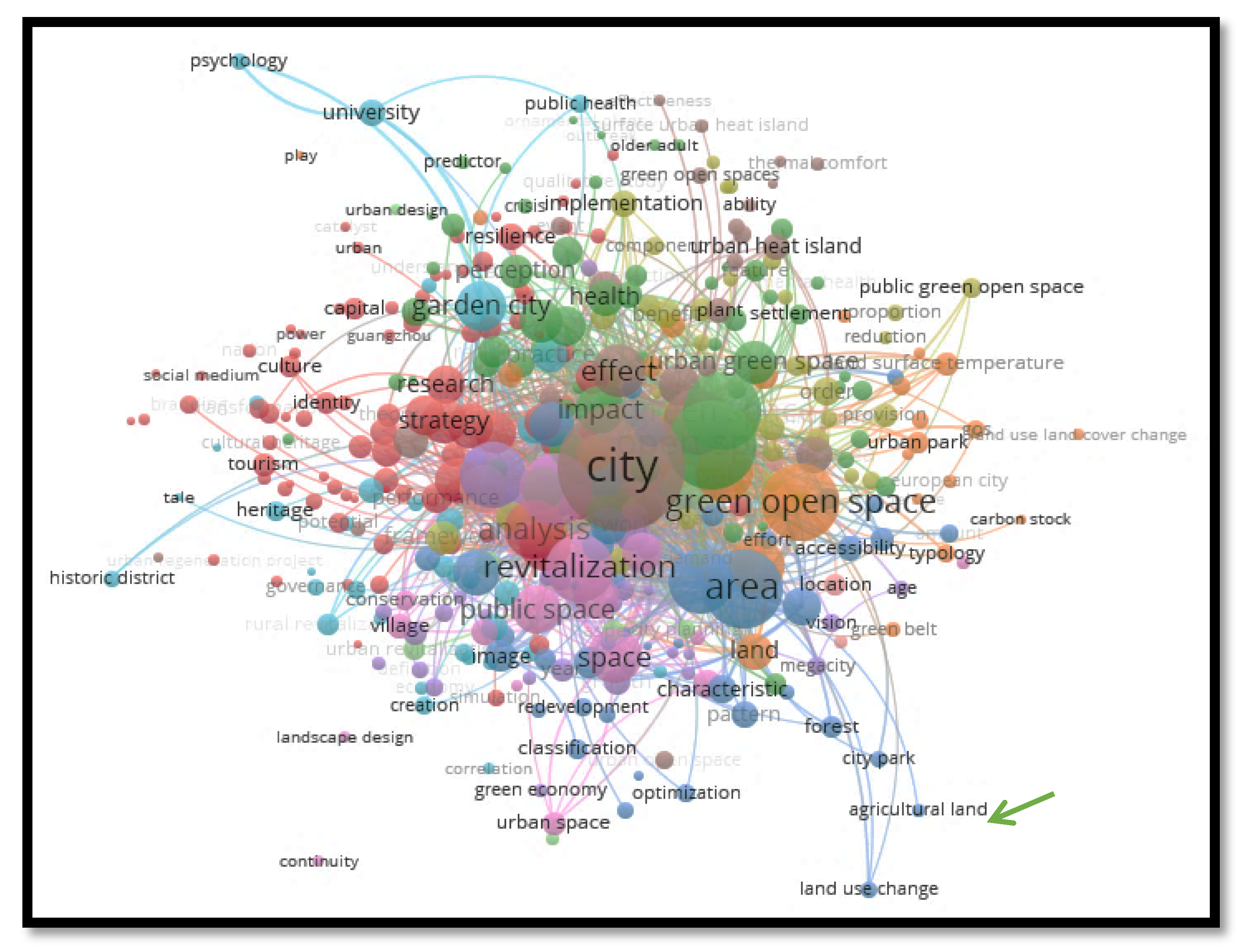
Figure 2.
Situation of the research area (source: processed and modified from Google Earth, 2023).
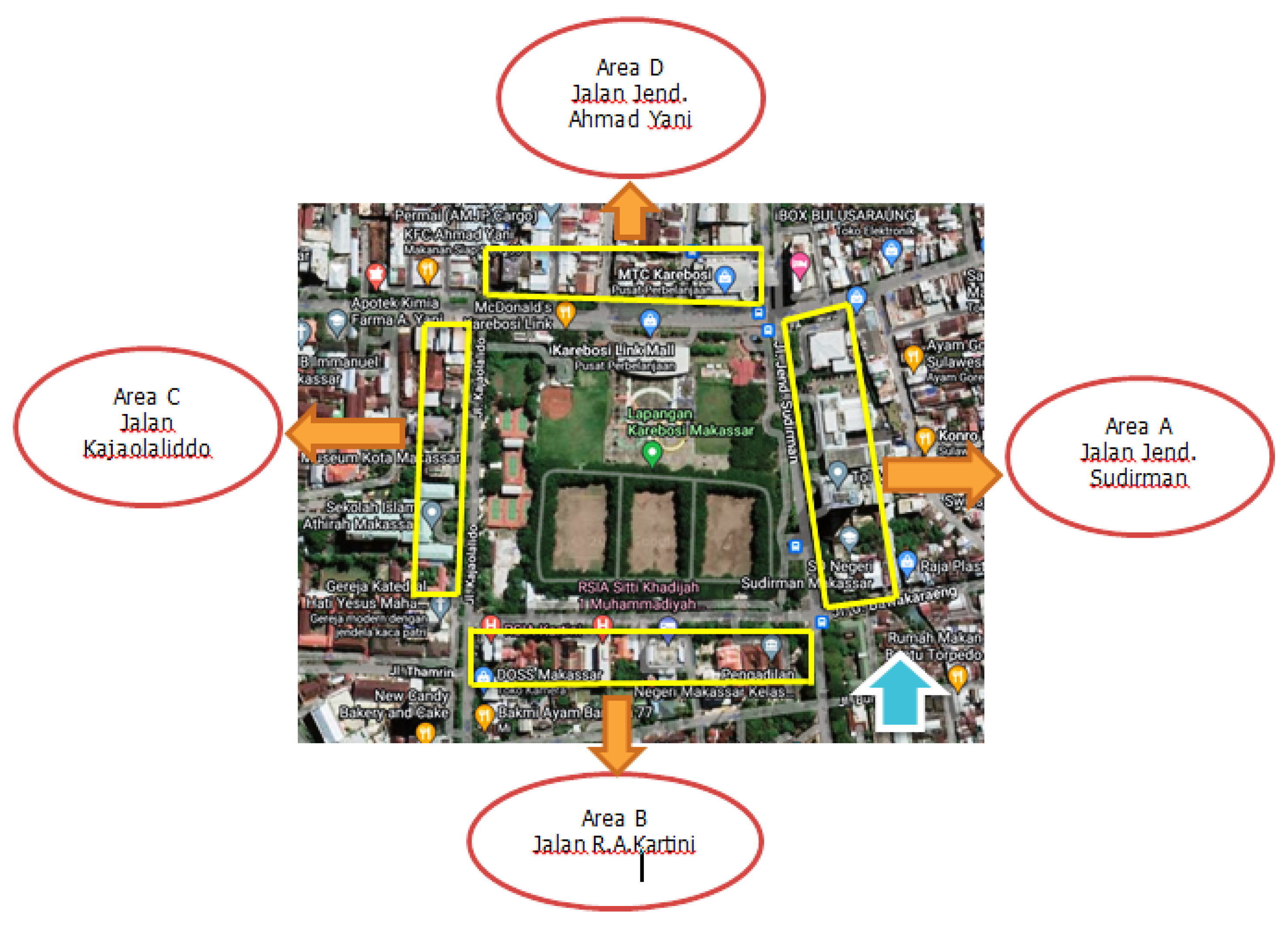
Figure 3.
20th Century Makassar City Map and Modifications. Source: Kitlv in (Kholifah, 2002).
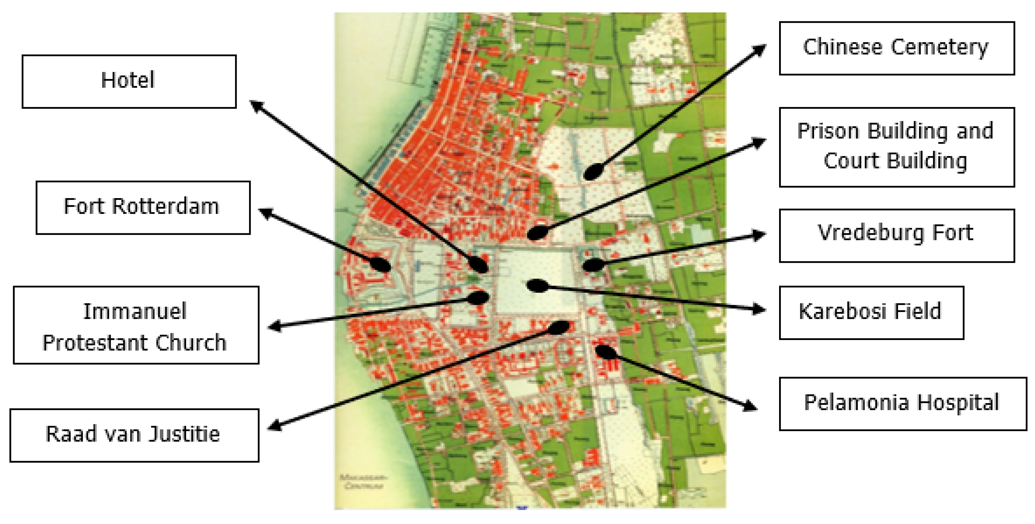
Figure 4.
Land Change Process in Area A. (Source: 2023 Survey Results). A1 = First change (Laboratory Building).
Figure 4.
Land Change Process in Area A. (Source: 2023 Survey Results). A1 = First change (Laboratory Building).
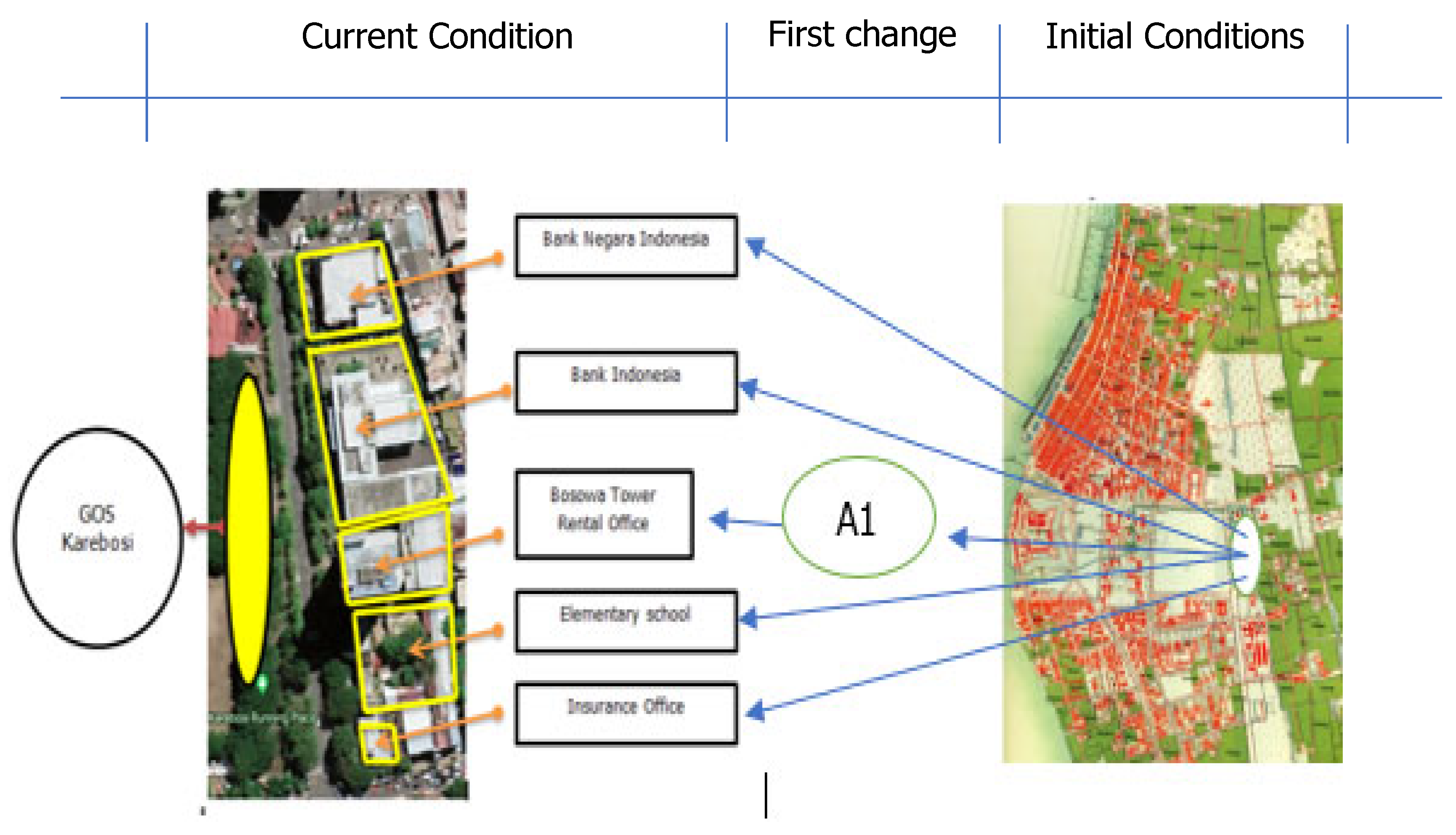
Figure 5.
Land Change Process in Area B. (Source: 2023 Survey Results). B1 = First change (Housing area).
Figure 5.
Land Change Process in Area B. (Source: 2023 Survey Results). B1 = First change (Housing area).
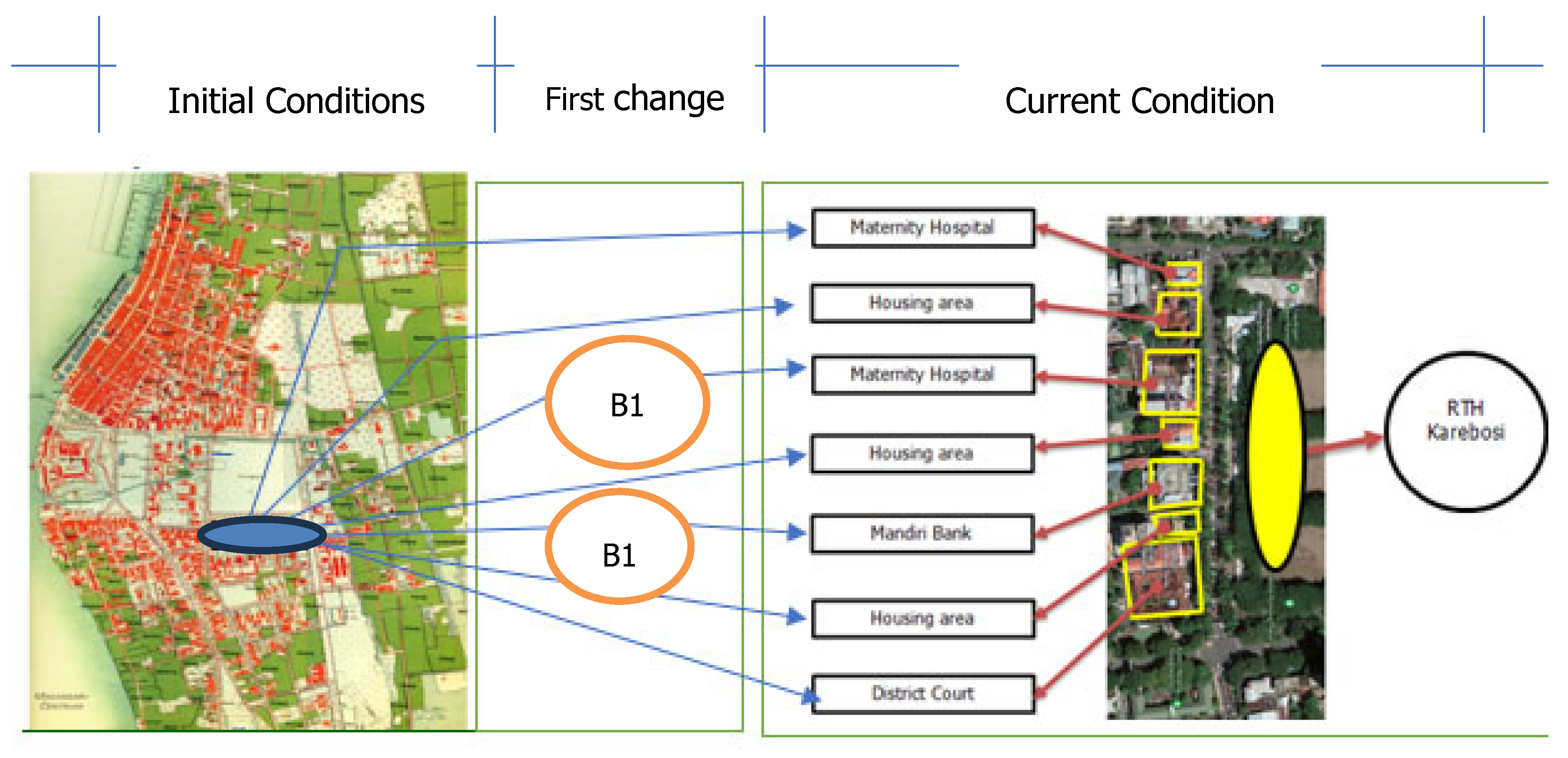
Figure 6.
Land Change Process in Area C. (Source: 2023 Survey Results) C1 = First change (Air Force Office).
Figure 6.
Land Change Process in Area C. (Source: 2023 Survey Results) C1 = First change (Air Force Office).
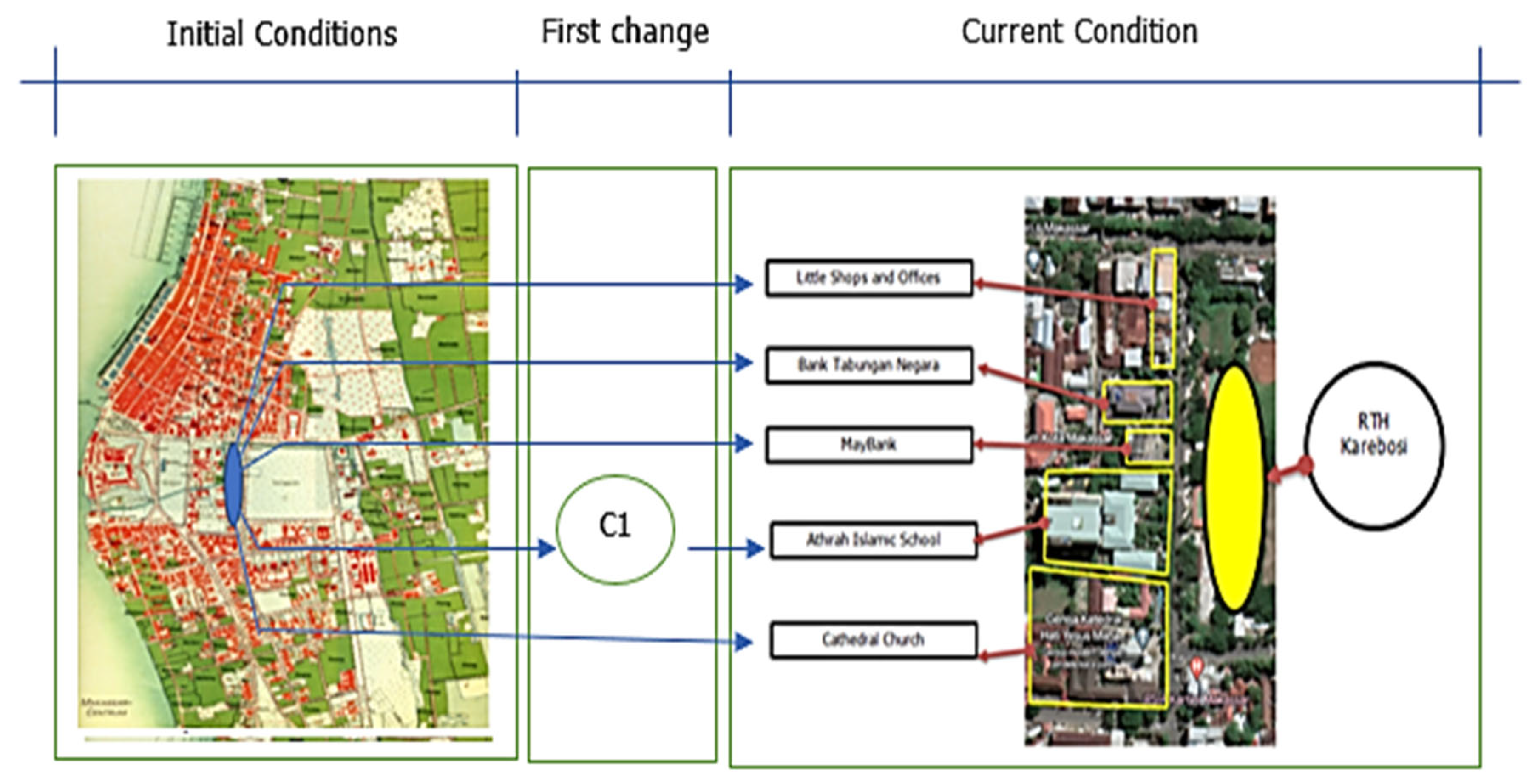
Figure 7.
Land Change Process in Area D. (Source: 2023 Survey Results). D1 = First change (Army Office). D2 = First change (Pulmonary Hospital).
Figure 7.
Land Change Process in Area D. (Source: 2023 Survey Results). D1 = First change (Army Office). D2 = First change (Pulmonary Hospital).
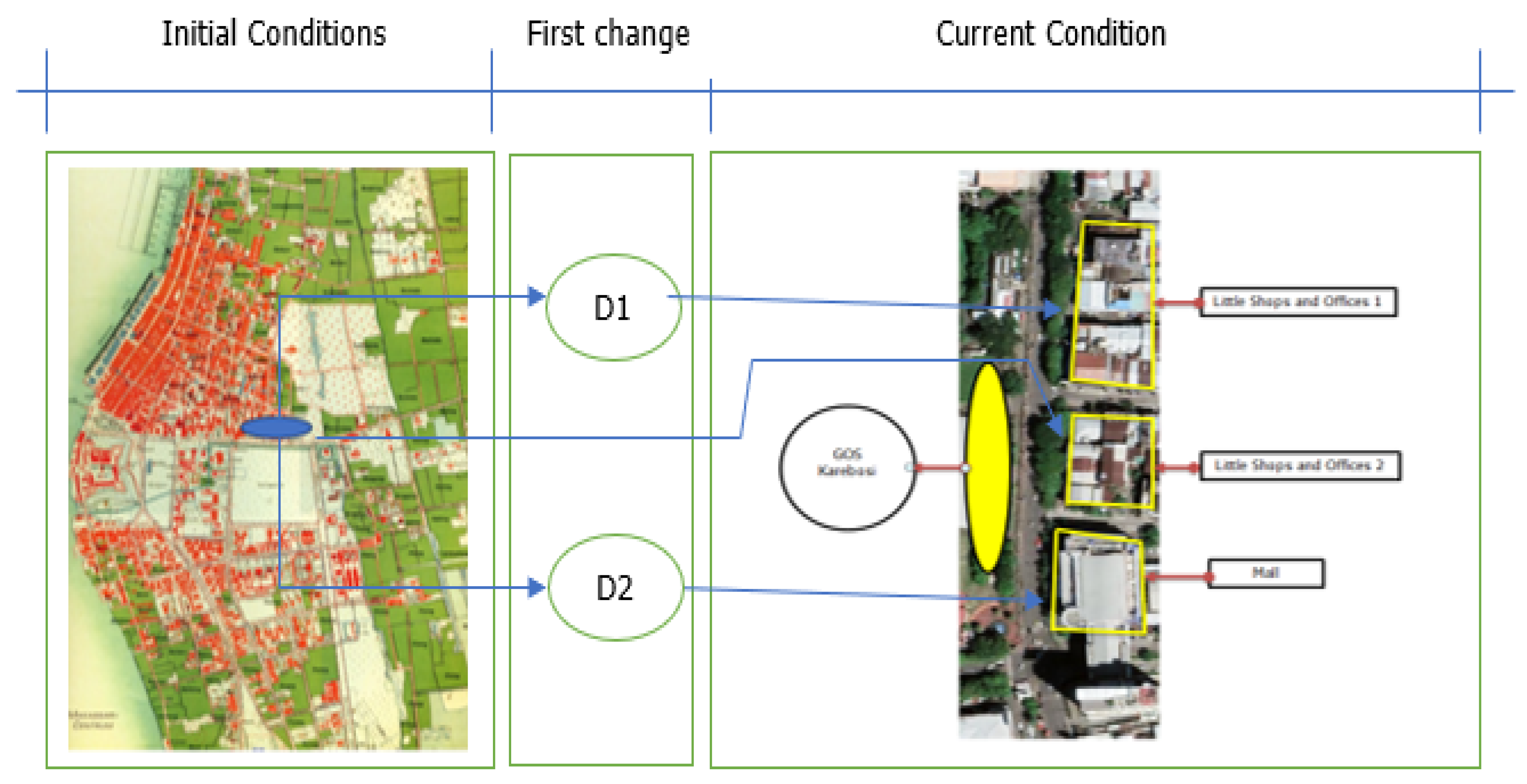

Table 1.
Grouping of topics by class
| Clusters | Consep Names | Total |
| Clusters 1 | adoption, analysis, availability, behavior, bibliometric analysis, branding, capital, case, catalyst, characteristics, circular economy, city branding, community, communication, comparative study, comparison, conceptual framework, concern, context, critical review, cultural ecosystem services, cultural heritage, cultural policy, culture, determinant, education, efficiency, empirical study, field, figure, gap, green spaces, Guangzhou, history gardens, identity, industry, influence, influencing factor, innovation, institution, intention, investigation, knowledge, link, management, meaning, methodology, model, nation, open green spaces, outcomes, overtourism, pandemic, participation, path, performance, perspective, post covid, potential, power, promotion, prospect, renewal, research, research agenda, residential area, resilience, resources, review, role, rural area, scoping review, Shenzen, simulation, social medium, sport, strategy, student, systematic literature review, technology, theory, tool, tools, tourism, town, transformation, trend, urban, urban green infrastructure, urban green spaces, urban regeneration, urban regeneration project, urban renewal, word. | 94 |
| Clusters 2 | access, association, child, crisis, death, density, difference, distance, district, element, environment, experience, factor, feature, green space, ornamental plant, outbreak, park area, perception, person, physical activity, population, predictor, preference, preservation, qualitative study, quality, resident, risk, sample, settlement, size, soil, spatial distribution, stress, systematic review, tourist, treatment, understanding, urban green space, urban planning, use, women. | 62 |
| Clusters 3 | accessibility, agricultural land, amount, approach, area, central business district, characteristic, city park, classification, crime, deep learning, distribution, driver, effort, Europe, forest, form, function, GIS, guideline, history, image, land use change, landscape architect, mapping, network, open area, optimization, park, pattern, policy, public open space, race, redevelopment, remote sensing, safety, selection, square, term, type, urban sprawl, user. | 43 |
| Clusters 4 | Application, barrier, benefit, biodiversity, climate change, climate change adaptation, component, conflict, construction, demand, diversity, ecosystem service, framework, goal, green infrastructure, green roof, home, implementation, improvement, lesson, mitigation, open space planning, order, park space, plan, priority, process, proportion, provision, public, green open space, recovery, recreation, reduction, society, solution, street, tree, urban forest, value, vegetation, water, wellbeing, work | 43 |
| Clusters 5 | Age, art, artificial intelligence, bag data, comparative analysis, country, definition, development, dimension, economy, food, future, green, green economy, growth, indicator, issue, low, light, megacity, observation, patient, position, relation, response, search, smart city, social capital, social sustainability, source, sustainability, sustainable city, sustainable development, transport, urban development, vision, welwyn garden city, year, | 38 |
| Clusters 6 | Attitude, Chinese city, community garden, correlation, creation, economic development, evidence, evolution, facility, garden city, gentrification, geography, governance, heritage, historic district, mechanism, mediating role, politic, practice, psychology, public health, regeneration, region, rural revitalization, rural settlement, site, spatial pattern, state, sustainable development, sustainable urban development, tale, transition, university, urban form, urbanization, view. | 36 |
| Clusters 7 | Adaptation, carbon stock, challenge, change, climate change mitigation, estimation, European city, focus, GIS, green belt, green open space, infrastructure, land, land surface temperature, land use, land use land cover change, leisure, literature review, opportunity, park, part, place, play, relationship, sense, service, set, typology, urban green open space, urban park. | 30 |
| Clusters 8 | Ability, assessment, building, city, effect, effectiveness, evaluation, event, formation, green city, green open spaces, green synthesis, historical city, lack, landscape architecture, plant, problem, remote sensing data, structure, study, surface urban heat island, technique, thermal comfort, urban area, urban heat island, urban heat island effect, urban open space, utilization | 28 |
| Clusters 9 | Aesthetic, architecture, case study, concept, condition, conservation, continuity, garden, green area, public space, revitalization, space, urban landscape, village, estimation, European city, focus, green belt, green open space | 19 |
| Clusters 10 | Agriculture, contribution, gardening, location, system, urban agriculture, urban environment, urban sustainability. | 8 |
| Clusters 11 | Aspect, city planning, combination, planning, survey, urban design, urban revitalization. | 7 |
Source: vosviewer analysis.
Table 2.
The Process of Land Change Around GOS Karebosi from the Early 20th Century – 2022.
| No | Region | Initial Conditions | First change | Second change | Information |
| 1 | A | Vredeburg Fort and Hospital | Bank Negara Indonesia, Bank Indonesia, Chemical Analysis Building, Elementary School, Office | Bank Negara Indonesia, Bank Indonesia, Bosowa Tower, Elementary School, Office | |
| 2 | B | Raad Van Jastitie and Around | Raad Van Jastitie, Housing | Pengadilan Negeri, Bank Mandiri, Hospital, Housing, Maternity Hospital | |
| 3 | C | Immanuel Protestant Church and Hotel | Immanuel Protestant Church, Air Force Headquarters, Shops | Immanuel Protestant Church, Athirah Islamic School, Banks, Shops | |
| 4 | D | Prison Building and Court Building | Lung Hospital, Prison, Army Headquarters. |
Shopping Malls, Shops |
Source: 2023 Observations.
Disclaimer/Publisher’s Note: The statements, opinions and data contained in all publications are solely those of the individual author(s) and contributor(s) and not of MDPI and/or the editor(s). MDPI and/or the editor(s) disclaim responsibility for any injury to people or property resulting from any ideas, methods, instructions or products referred to in the content. |
© 2026 by the authors. Licensee MDPI, Basel, Switzerland. This article is an open access article distributed under the terms and conditions of the Creative Commons Attribution (CC BY) license (http://creativecommons.org/licenses/by/4.0/).
Copyright: This open access article is published under a Creative Commons CC BY 4.0 license, which permit the free download, distribution, and reuse, provided that the author and preprint are cited in any reuse.


