Submitted:
18 February 2026
Posted:
27 February 2026
You are already at the latest version
Abstract
Cultural heritage sites in arid regions are often underestimated in terms of flood risk; however, the increasing frequency and intensity of extreme precipitation events under climate change have significantly amplified threats to these fragile environments. Taking the Xixia Imperial Tombs in China as a case study, this research investigates strategies for flood hazard prevention and control for cultural heritage in arid areas. By situating the study within the broader context of climate change and global heritage conservation, the paper examines the impacts of flooding on heritage sites and the historical evolution of flood control measures. It further integrates an analysis of the site’s geographical characteristics, traditional flood management structures, and contemporary conservation practices.
The study systematically elucidates the compound risks of “drought–desertification–sudden flooding” faced by cultural heritage in arid landscapes. The findings suggest that heritage protection should transition from reactive, post-disaster restoration to-ward proactive preventive conservation. This shift requires the integration of both engineering and non-engineering measures, supported by technology-based systems such as environmental monitoring and early warning platforms, to establish a comprehensive risk management framework. The research highlights that overcoming the prevailing misconception that “arid regions are free from flood risks,” embedding heritage flood management into regional planning, and ensuring legal, financial, and interdisciplinary cooperation are essential for the long-term safeguarding of cultural heritage in arid environments. This study offers practical insights and a transferable reference for the protection of heritage sites in similar climatic and geographical contexts worldwide.
Keywords:
Xixia Imperial Tombs
; cultural heritage protection
; arid regions
; flood risk management
; preventive conservation
; climate change adaptation
1. Introduction
Climate change and governance have become central of global attention. Rising global temperatures have led to changes in air humidity, extreme weather events, hurricanes, floods, and a range of other meteorological phenomena. At the same time, the vulnerability and irreversibility of damage to cultural heritage have brought heritage protection to the forefront of international cultural agendas. In 2019, the ICOMOS Climate and Heritage Working Group published a report based on expert consultations, summarizing key climate factors, their mechanisms and their impacts, thereby further underscoring the importance of environmental and climate governance research for cultural heritage protection. (ICOMOS, 2019)
According to the latest statistics from UNESCO, the World Heritage List contains 1,248 properties from 170 contracting States Parties, including 972 cultural heritage sites and 235 natural heritage sites (UNESCO, 2025). Both indoor and outdoor cultural heritage are increasingly exposed to risks of deterioration, making the development of targeted and effective protection measures both urgent and necessary. Due to its geographical specificity, outdoor heritage is particularly influenced by regional topography, environmental conditions, climate factors, and human activities; therefore, the protection of outdoor cultural heritage must place special emphasis on regional environmental governance.
Floods are among the most frequent natural disasters worldwide, with Asia being the most seriously affected continent (Nobile et al., 2025). With the accelerating impacts of climate change and urbanization, both the frequency and intensity of extreme precipitation and flood events in Asia continue to increase. Despite this growing risk, research on flood-induced damage to cultural heritage in arid regions remains notably limited, as does research on flood prevention and mitigation strategies. In the context of China in particular, studies integrating flood risk management with the protection of local cultural heritage are still scarce, revealing a significant gap between disaster risk research and heritage conservation practice.
In July 2025, the Xixia Imperial Tombs were nominated for inscription in the World Heritage List under criteria (ii) and (iii) as defined by the Operational Guidelines for the Implementation of the World Heritage Convention (2023 edition). The nominated property encompasses an extensive area, incorporating not only the Imperial Tombs themselves but also the broader historical environment, including surrounding mountains, Gobi landscapes, and the inherent spatial relationships between the tombs and the natural terrain. In addition, in anticipation of the potential development pressures from surrounding urban areas, the nomination delineates a sufficiently large area to ensure the comprehensive protection of all attributes conveying the Outstanding Universal Value of the Xixia Imperial Tombs and their environmental setting.
Against this background, this study aims to identify and analyze specific flood risk prevention and mitigation measures at the Xixia Imperial Tombs through case-based analysis and consideration of regional environmental characteristics. By doing so, it seeks to reframe the understanding of flood risk management in cultural heritage contexts and to propose targeted control strategies and recommendations addressing flood-related damage to cultural heritage in arid regions.
2. Climate Change and Global Cultural Heritage
The intensification of natural disasters and the expansion of human activities pose increasing threats to regional cultural heritage. According to ICOMOS (2010), disaster risks to cultural heritage can be categorized into predictable deterioration and unpredictable disasters, the latter of which include events caused by natural phenomena as well as human behavior.
Sesana et al. (2021) highlights the critical importance of cultural heritage and the growing risks posed by climate change. Through a systematic literature review of studies published between 1999 and 2020, the author classifies existing research into three main categories: outdoor heritage, indoor heritage and the natural physical environment. Regarding outdoor heritage, Sesana argues that gradual climate changes accelerate long-term degradation processes, while sudden climatic stressors—such as extreme precipitation, flooding, and strong winds—can cause abrupt damage and further intensify deterioration. The study also emphasizes the synergistic effects of multiple climate factors and significant regional differences in vulnerability. Climate change is shown to have widespread impacts on cultural heritage, with risks varying considerably across different climate regions. Consequently, the author stresses the necessity of developing preventive conservation measures and adaptive management strategies in response to climate change. The review concludes that although existing research adopts a global perspective, it is heavily concentrated in Europe, with relatively limited studies focusing on regions such as Asia and Africa.
Orr et al. (2021) also employed a systematic literature review to examine research on climate change and cultural heritage published between 2016 and 2020. Findings indicate that although this field has expanded rapidly, significant limitations remain in terms of geographical coverage, heritage types, and research methodologies. Studies addressing specific heritage categories—such as underwater cultural heritage and heritage located in arid regions—are notably scarce. Existing research is largely concentrated within disciplines such as climate science, archaeology, and architecture, while interdisciplinary collaboration remains limited. The study further underscores the urgent need for enhanced global cooperation and knowledge exchange to advance research on climate change and impacts and adaptive strategies for cultural heritage.
According to the data from UNESCO World Heritage Center, as of December 2025, there were 1,248 World Heritages properties inscribed on the World Heritage List, spanning 170 countries, of which the majority are cultural properties. Among these, cultural heritage sites accounted for approximately 77.8%, while natural heritage made up about 18.8%, and mixed properties (both cultural and natural) represented about 3.3% of the total. Europe and North America together host around half of all heritage sites, with countries such as Italy (61), Germany (55), France (54) and Spain (50) featuring particularly high numbers of cultural properties. In contrast, Asia’s share of cultural heritage sites is lower in absolute terms, with 306 cultural sites--approximately half the number found in Europe and North America--although the region ranks among the top in terms of mixed heritage properties. This uneven distribution highlights geographical imbalances in World Heritage inscriptions.
Although catastrophic events resulting from increasingly severe meteorological and environmental challenges occur frequently, such disasters cannot be understood in isolation, as they are influenced by social, economic, historical, political, and cultural factors. The International Council on Monuments and Sites (ICOMOS) advocates that heritage conservation should adhere to the principle of “minimum intervention to significant fabric and use,” emphasizing that heritage protection seeks to maintain a balance between safety and heritage value (Bosher et al., 2020). Consequently, the formulation of appropriate disaster risk reduction and mitigation strategies is essential for effective heritage conservation.
In Europe, the flood management strategies have evolved from a singular focus on “flood control” toward a more comprehensive approach to “risk management”, with the European Union’s Floods Directive serving as a central framework. According to Directive 2007/60/EC on the assessment and management of flood risks, flood risk management should address not only prevention and protection measures, but also the safeguarding of vulnerable communities, economic activities, and cultural heritage (Directive 2007/60/EC, Art. 7).
3. Flood Risk and Cultural Heritage Protection: From Response to Prevention
Existing studies demonstrate that flood risk poses a pervasive and often irreversible threat to cultural heritage (Vojinovic et al., 2016), requiring governance approaches that move beyond post-disaster response toward preventive and integrated risk management. In Italy, a country that possesses one of the world’s largest concentrations of cultural heritage and has been repeatedly affected by severe flooding, has a long history of flood-related disasters, dating back to the Polesine flood in 1951. Following the catastrophic Florence flood in 1966, Italy began to formulate flood management standards and policies in response to flood-prone areas. Mysiak et al. (2013) evaluated the existing conditions and challenges of flood risk management in Italy and proposed a set of joint recommendations to reform the national governance model, taking advantage of the opportunities offered by the European Union’s Floods Directive. They characterize Italy’s flood risk management approach as largely “disaster-driven”, arguing that its legal and policy frameworks have predominantly emerged as reactive responses to major flood events rather than from forward-looking and systematic planning. This reactive orientation has resulted in a strong emphasis on emergency response while comparatively neglecting risk prevention and mitigation. Consequently, the study advocates for a paradigm shift in Italy’s flood risk management—from a passive and response-oriented model to a modern governance framework that is proactive, preventive, and strongly oriented toward public participation.
A similar limitation in existing flood governance frameworks is identified in the Czech Republic. Holický and Sýkora (2010) evaluated and analyzed flood risk to cultural heritage sites in the Czech Republic and proposed an operational assessment framework for heritage protection in flood-prone areas from an event-based perspective. Their study identifies inadequate structural performance and insufficient communication among stakeholders—particularly in relation to geotechnical engineering—as primary causes of damage to heritage sites in Prague following major flood events. Furthermore, the authors clearly demonstrate that, at the time of their study, the European Union Floods Directive and related guidelines did not sufficiently account for the specific vulnerabilities and conservation requirements of cultural heritage.
In contrast, research from Taiwan places stronger emphasis on preventive and spatially integrated approaches. Wang (2014) explored the application of flood risk maps for cultural heritage protection using Xinbei City as a case study. By employing Geographic Information System (GIS) techniques, the study overlaid 113 local cultural heritage sites with flood simulation maps under multiple rainfall scenarios, enabling the identification of at-risk heritages assets prior to flood events. A key contribution of this study lies in its explicit linkage between climate change, increasing flood frequency, and the irreversible nature of heritage loss, reinforcing the necessity of preventive conservation. Wang further proposes a non-engineering disaster risk reduction strategy that utilizes urban parks as temporary flood retention and discharge areas, thereby redirecting floodwaters away from heritage sites and integrate cultural heritage protection into broader urban green infrastructure and flood management planning.
Recent scholarship has increasingly focused on improving flood risk assessment methodologies and integrating advanced digital technologies into cultural heritage protection. Nobile et al. (2025) investigated the applicability of flood disaster maps with varying spatial resolutions for assessing flood risks to cultural heritage and proposed a cross-national, standardized risk assessment approach. By combining existing semi-quantitative risk assessment frameworks, the authors developed a model that is largely independent of regional characteristics. Their findings reveal significant uncertainties in the application of large-scale flood maps for cultural heritage protection, highlighting the need for finer-scale modeling and improved data integration. In particular, the study emphasizes that the spatial distribution of cultural heritage assets must be explicitly incorporated into flood risk mapping to avoid the omission of culturally significant but spatially dispersed sites. While traditional engineering measures such as dams and canals remain intuitive and effective flood control solutions, their limitations have become increasingly evident under the intensifying impacts of climate change. Climate change is expected to lead to more frequent extreme rainfall events and increased peak river flows, thereby challenging the reliability of conventional flood protection infrastructure (Arnbjerg-Nielsen et al., 2013; Pelling, 2011).
In the context of outdoor tangible cultural heritage, technical conservation solutions are relatively mature, with approximately 92% of proposed interventions already implemented (Mendoza et al., 2023). At the same time, emerging digital technologies are expanding the scope of heritage management and protection. Augmented reality (AR), for instance, has been demonstrated to be an effective tool for cultural heritage documentation, monitoring, and public engagement (Boboc et al., 2022).
Beyond technical tools, recent studies stress the importance of integrating social and participatory dimensions into heritage protection strategies. Trček (2022) explored the application of blockchain technology in cultural heritage protection, emphasizing the intrinsic relationship between heritage and tourism. The study argues that effective heritage protection requires the joint consideration of technical and social factors. Due to its decentralized, tamper-proof, and transparent characteristics blockchain technology is presented as a promising solution for coordinating multiple stakeholders. Denis proposes a novel blockchain architecture optimized for mobile devices, based on the principle of “contribution ware,” in which tourists participate in maintaining the blockchain through their mobile phones, thereby fostering a synergistic relationship between heritage protection and tourism.
Similarly, Laguna-Palma et al. (2024) examined the application of remote sensing and digital technologies in cultural heritage protection in northeastern North Africa. Focusing on the Mare region of Marica, the study identifies dual threats to cultural heritage arising from human activities—such as urban expansion and agricultural intensification—and natural factors, including erosion and climate change. By integrating historical maps, aerial photographs and multi-time series satellite imagery, the author systematically identified, recorded and mapped archaeological sites. On this basis, they established a comprehensive database incorporating a risk assessment framework that quantifies and classifies threats, resulting in detailed “digital records” for endangered heritage sites.
Taken together, these studies indicate a clear shift in flood risk management for cultural heritage—from reliance on single-purpose engineering solutions toward comprehensive risk governance approaches that integrate risk management, monitoring, early warning systems, and adaptive planning. Flooding remains one of the most significant threats to cultural heritage worldwide: approximately 21% of cultural heritage sites have been affected by floods, and around 2% are exposed to the risk of extreme flooding (Arrighi et al., 2023). Within this context, the concept of “preventive conservation” has emerged as a foundational principle for risk mitigation. Effective cultural heritage protection therefore requires the implementation of flood management strategies through a combination of structural and non-structural measures, supported by interdisciplinary collaboration across engineering, environment science, digital technology, governance, and heritage studies.
4. Protection of Cultural Heritage and Flood Control in Arid Areas
In arid regions, flood risks are often overlooked due to the long-term drought conditions. Consequently, when extreme precipitation and other weather events occur, they tend to cause more severe damage, posing a significant threat to fragile cultural heritage. In this light, Berenfeld (2008) examines the concrete and imminent risks to cultural heritage worldwide arising from global climate instability and calls for new, cooperative response strategies in the field of heritage conservation. By translating climate change from an abstract concept into a tangible and operational challenge for heritage practitioners, the study advocates for a fundamental shift in both conceptual frameworks and practical approaches to heritage protection. Berenfeld’s research documents a wide range of local case studies, including the Chinguetti Mosque in Mauritania and stone heritage sites in Senegal, which face serious threats from desert expansion, intense rainfall, and soil erosion. In the case of the Chinguetti Mosque, the deterioration of building materials is driven by prolonged desertification combined with sudden flood events. When rare but heavy rainfall occurs, the arid soil--hardened by long-term drought--cannot absorb water efficiently, causing rapid surface runoff that develops into flash floods and impacts earthen and soil-based architectural structures. Scholars have increasingly recognized that cultural heritage in arid and desertifying regions is subject to a compound risk in which drought and rainfall-induced erosion coexist. However, despite this recognition, clear and systematic solutions or adaptive strategies tailored to such compound hazards remain largely underdeveloped.
In arid and desert regions, the impacts of climate change are not singular but cumulative. A destructive cycle of drought-desertification-sudden flooding has emerged, jointly acting upon fragile cultural heritage sites. Climate change is systematically destabilizing heritage assets that have survived for millennia within relatively stable environmental conditions through a series of interconnected physical processes. Qu et al. (2014) examined desertification control measures at the Mogao Grottoes and Crescent Spring in Dunhuang, China, illustrating the unintended consequences of large-scale environmental interventions at heritage sites.
To combat desertification, extensive afforestation programs have been implemented in Dunhuang since the 1950s. However, irrigation of shelterbelts has increased soil moisture and ambient humidity within the grottoes, exacerbating salt efflorescence, microbial growth, and the peeling of murals at the Mogao Grottoes. Simultaneously, excessive groundwater extraction has led to a significant decline in the water level of Crescent Spring. While shelterbelts reduce wind velocity, they also altered sand dune dynamics, increasing the risk of sand burial at the site. Moreover, expanded vegetation has introduced biological threats, including insects, birds, and rodents, which directly damages the heritage fabric. Qu et al. (2014) argue that, in the absence of a comprehensive understanding of ecosystem complexity, maintaining the original environmental state may constitute the most effective conservation strategy. This study serves as a cautionary reminder that cultural heritage is often preserved within highly specific environmental equilibria, and artificial environmental modification must therefore be approached with exceptional care.
Building on this environmental perspective, Rössler and Lin (2018) elaborate on UNESCO’s conceptual framework and practical approaches to cultural landscape protection, with particular attention to the distinct challenge faced in Asia. The study notes that cultural landscapes worldwide are increasingly threatened by infrastructure expansion, rapid urbanization, and climate change, pressures that are especially pronounced in fast-developing Asian regions. In response, UNESCO promotes a territorial and holistic approach that integrates culture, history, and nature. Cases studies from Bhutan, the Bamiyan Valley in Afghanistan, and the Silk Road Heritage Corridor demonstrate that effective conservation management depends on placing local communities at the center of governance, fostering inclusive decision-making, and embedding heritage protection within broader territorial and development planning. The authors further emphasize the need for future research and policy efforts in Asia to strengthen regional and national legal frameworks for landscape protection and to enhance interdisciplinary cooperation.
5. Materials and Methods
As outlined above, the primary objective of this study is to collect and analyze data related to flood control projects and cultural heritage protection, with a particular focus on identifying and evaluating flood risk management measures at the Xixia Imperial Tombs. Through this analysis, the study seeks to reconstruct and critically examine prevailing perceptions of flood risk management in arid-area cultural heritage sites.
The research adopts a qualitative, multi-method approach. First, archival research was conducted using historical documents, technical reports, photographs, and planning materials housed at the Xixia Imperial Tombs Museum and the Ningxia Institute of Archaeology. Only materials approved for public or academic use by the relevant cultural heritage authorities were examined. These sources were systematically reviewed to trace the historical evolution, objectives, and implementation processes of flood control interventions at the site.
Second, fieldwork was undertaken through targeted on-site observation. The author conducted multiple site visits to the Xixia Imperial Tombs, documenting the physical condition of the heritage remains and the performance of existing flood control infrastructure through direct observation and photographic recording. Field observation enabled a detailed assessment of flood-related damage patterns as well as the effectiveness and limitations of current flood mitigation measures.
Finally, the collected archival and field data were subjected to comparative and thematic analysis. By triangulating documentary evidence with on-site observations, the study identifies key challenges and implications of flood risk management in arid-area heritage contexts. This analytical process led to the formulation of three central research questions: (1) Why is flood control and risk management critically important for the Xixia Imperial Tombs? (2) What broader implications does flood risk management hold for cultural heritage in arid and desert environments? And (3) How might flood control strategies and risk governance at the Xixia Imperial Tombs evolve in the future?
6. Historical Background of Xixia Imperial Tombs
Xixia Imperial Tombs constitute the royal mausoleum group of Xixia Dynasty (11th to 13th century A.D.) and represent the largest, highest-ranking, and best-preserved archaeological site from the Xixia period (UNESCO, 2025). The site is located on an alluvial fan at the eastern foothills of the Helan Mountain, approximately 35km west of Yinchuan City in the Ningxia Hui Autonomous Region, China. Extending from Quanqigou in the north to the Yinba Highway in the south, the tomb complex spans approximately 10km from north to south and a width of 4km from east to west, covering an area of nearly 40 km2 (Figure 1). The Imperial Tombs area comprises 9 imperial mausoleums and 271 associated subordinate burials, occupying a core area of approximately 5.03 hectares, and is supported by 32 flood control structures (UNESCO, 2025). In addition, numerous kiln sites used for firing bricks and ceremonial objects are distributed across the eastern sector of the cemetery.
Although the Xixia Imperial Tombs were largely destroyed by the Mongol forces following the collapse of the Xixia Dynasty in the early thirteenth century, leaving only remnants of walls and architectural ruins, the original scale and ceremonial order of the complex remain evident. The spatial layout, monumental earth mounds, and axial organization of the cemetery convey the former grandeur of the above-grounds structures (Figure 2). As with most imperial mausoleums in traditional China, the construction of the Xixia Imperial Tombs reflects cosmological principles rooted in the balance of Yin and Yang and practice of Fengshui. The selection of the burial site was based on the belief that harmony between natural forces would ensure the eternal preservation of the ruler’s spirit and the continuity of the landscape. Consequently, the cemetery was deliberately located on gently sloping terrain, backed by prominent mountains that were regarded as “sacred mountains” imbued with spiritual significance (WANG, 1985). During his lifetime, the Xixia ruler would use the Helan Mountains as a royal hunting and ceremonial ground, where activities such as hunting expeditions, banquets, and court assemblies were held (Xu & Wang, 1986). After death, the monarch was symbolically returned to this sacred landscape, reinforcing the enduring connection between royal authority, natural geography, and mortuary practice in Xixia culture.
The heritage site is mainly divided into four zones based on the clustering and distribution of tombs. As illustrated in Figure 3, Aera I comprises two principal imperial mausoleums (LM1 and LM2), 66 associated subordinate burials (MI-001 to MI-066), three flood control wall structures (QI-01 to QI-03), and two flood discharge channels (GI-01 to GI-02). Area II contains two principal mausoleums (LM3 and LM4), 67 subordinate burials (MII-001~MII-067), eight flood control wall structures (QII-01 to QII-08) and four flood discharge channels (GII-01 ~ GII-04). Area III comprises two principal imperial mausoleums (LM5 and LM6), 118 subordinate burials (MIII-001 to MIII-118), and 15 flood control wall structures (QIII-01 to QIII-15). Area IV includes three principal imperial mausoleums (LM7, LM8 and LM9), 20 subordinate burials (MIV-001 to MIV-020), and the Northern Architectural Complex Site (F). At present, Areas I and II are open to the public, whereas Areas III and IV are subject to restricted access and remain under conservation-focused protection.
7. Protection of Rammed Earth Sites
The Xixia Imperial Tombs’ primary architectural structures are constructed using rammed earth technology. The conservation of rammed earth heritage is widely recognized as a global challenge. Although rammed earth construction techniques emerged as early as the Neolithic period and were extensively employed in ancient architecture, it is relatively rare for such structures to remain in a comparatively intact state after centuries or millennia of exposure to wind, rain, and other environmental stressors.
At the Xixia Imperial Tombs, the stratified construction of rammed earth is clearly visible in both the surviving walls and the tall mausoleum towers (Figure 4), reflecting a typical ancient building practice in which soil was compacted layer by layer through repeated ramming (Meng, 2012). Archaeological investigations have further revealed that, in the mausoleum tower of No.3, carefully selected white lime and gravel were mixed into the rammed earth in specific proportions. This compositional refinement significantly enhanced the compressive strength and durability of the earthen structures, demonstrating a high level of technical knowledge in Xixia construction practices.
Despite these material and technological advantages, the Xixia Imperial Tombs are inevitably subject to natural aging processes. Located within an arid to semi-arid climatic zone, the site faces multiple environmental threats, including flood-induced gully erosion, drought-related cracking, and progressive surface weathering. If left unaddressed, the cumulative effects of these processes can compromise the long-term structural stability of the monuments. Particularly severe is the combined impact of salt crystallization and flooding. Salts are transported into the earthen fabric by infiltrating water and subsequently crystallize as moisture evaporates, generating internal stresses through volumetric expansion (Meng, 2012). Repeated cycles of dissolution and crystallization gradually weaken the rammed earth, leading to loosening, flaking, and surface detachment. Under such conditions, sudden flash floods can trigger gully erosion that may cause rapid and irreversible damage to the earthen structures.
8. Sites Historical Flood Control Project of Xixia Imperial Tombs
Although the Xixia Imperial Tombs are in a desert region characterized by low annual precipitation, the risk posed by episodic and concentrated heavy rainfall during the summer season should not be underestimated. Vegetation cover on the Helan Mountains is sparse, and the tomb complex is situated on an alluvial fan at the mountain’s eastern foothills. These geomorphological conditions amplify the intensity and destructive potential of flash floods when they occur. In recognition of this environmental risk, flood control considerations were incorporated into the original construction of the Xixia Imperial Tombs. A system comprising flood drainage channels and flood control walls—amounting to a total of 32 identified flood control engineering structures—was designed to divert mountain torrents and safeguard the mausoleum complex (UNESCO, 2025).
Ancient flood control walls were typically constructed in areas characterized by elevated terrain and rapid water flow. Built primarily of stone and backfilled with loess, these structures were intended to enhance stability while effectively blocking, dissipating, and redirecting the force of mountain floods. Flood drainage channels, by contrast, were directly excavated into the ground and strategically aligned with natural topographic gradients to guide rainwater and surface runoff away from the protected core areas of the mausoleum complex (Meng, 2012). Together, these hydraulic engineering elements and the mausoleum architecture form an integrated landscape system, constituting valuable material evidence for the study of ancient water management and disaster prevention technologies.
Despite their significance, these flood control facilities—constructed precisely in areas subject to severe erosion—received limited attention during the early stages of archaeological research at the Xixia Imperial Tombs. As a result, many flood control walls and drainage channels fell into a state of deterioration, gradually losing their defensive function against flooding (Figure 5).
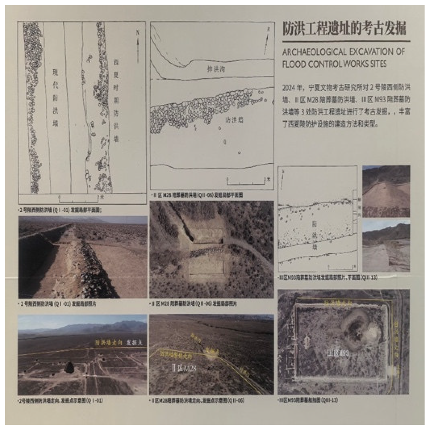
In 2024, the Ningxia Institute of Cultural Relics and Archaeology carried out archaeological excavations at three flood control engineering sites within the Xixia Imperial Tombs, including the flood control wall located on the western side of mausoleum No.2 and the flood control wall associated with the M93 subordinate burial in Area II. As shown in Figure 6, the flood control wall adjacent to the west side of Mausoleum No.2 dates to the Xixia period but has suffered significant deterioration due to its long exposure and historical use.
In accordance with the conservation principle of minimum intervention and respect for site authenticity, a new flood control wall constructed adjacent to the original structure. This intervention aimed to restore the functional capacity of the flood control system while preserving the original appearance and spatial integrity of the heritage site to the greatest extent possible (Ningxia Institute of Cultural Relics and Archaeology, 2024).
In 2020, an intense rainfall event triggered a sudden flash flood in the Helan Mountains, resulting in extensive damage to both natural ecosystems and cultural heritage sites in the region. In particular, the rock art sites of the Helan Mountains suffered severe damage. Owing to their unique geological and material characteristics, these rock paintings are inherently irreplaceable, and the flood caused irreversible losses, including surface rupture, exfoliation, and partial disappearance. Beyond the substantial economic damage, the event highlighted the vulnerability of outdoor cultural heritage to extreme hydrological hazards and the permanent nature of such losses.
Although the Xixia Imperial Tombs were not directly affected by this flash flood—largely due to the presence of flood control canals and flood control walls—the event nevertheless underscores the limitations of relying solely on engineering measures for cultural heritage protection. This emergency serves as a critical reminder for local authorities to confront the growing influence of extreme and largely uncontrollable climate-related factors on outdoor heritage sites. It further emphasizes the need to integrate engineering solutions with broader, context-sensitive environmental governance strategies. By aligning flood risk management with local climatic and environmental conditions and adopting multi-channel, interdisciplinary approaches, more resilient and adaptive frameworks for the protection of cultural heritage can be developed.
9. The Establishment and Application of a Protection System
9.1. The Concept of “Preventive Conservation”
UNESCO has emphasized that disaster risks to cultural heritage arise from both external and internal factors. External factors include sudden destructive events such as typhoons, tsunamis, and armed conflict, which can directly damage heritage assets. Internal factors, by contrast, relate to the inherent fragility of heritage structures and materials, as well as their sensitivity to environmental conditions (Wang, 2015).
The Xixia Imperial Tombs and the Mogao Grottoes in Dunhuang are both located in northwestern China and are exposed to comparable environmental pressures, including sandstorms, precipitation, intense solar radiation, and large temperature fluctuations. As a result, these two sites share important commonalities and potential complementarities in terms of conservation philosophy, technical approaches, and management strategies. The Dunhuang Academy has long maintained international cooperation with the Getty Research Institute in the field of heritage conservation and has played a pioneering role in introducing and advancing the concept of “preventive conservation” in China. This approach shifts the focus away from passive, post-damage restoration toward proactive, continuous monitoring and environmental control aimed at slowing the deterioration of cultural heritage.
At the Xixia Imperial Tombs, the core conservation challenge lies in the coexistence of a long-term arid climatic background and episodic but severe flood hazards, combined with the extreme fragility and non-renewable nature of the heritage fabric. In response and informed by the preventive conservation practices developed at Dunhuang, the protection strategy for the Xixia Imperial Tombs has gradually evolved from a predominantly rescue-oriented model to one centered on prevention, risk anticipation, and long-term environmental management.
9.2. Intelligent Monitoring System Empowered by Science and Technology
Since 2017, conservation efforts at the Xixia Imperial Tombs have entered a new phase in which “preventive conservation” has been adopted as the core strategic principle. As part of this shift, a dynamic site information, monitoring and early warning system was gradually introduced into the management of the site. In 2024, this system was comprehensively upgraded to the Xixia Imperial Tombs Heritage Monitoring and Early Warning Platform, significantly enhancing the precision of site protection and strengthening preventive conservation capacities through the application of advanced technologies.
Recent reports indicate that the monitoring and early warning platform integrates various technologies such as the Internet of Things (IoT), unmanned aerial vehicles (UAVs), satellite remote sensing, manual inspection, and mobile applications, establishing a comprehensive monitoring network that covers the heritage structures. This system enables closed-loop management, from continuous monitoring and risk identification to proactive prevention (Xinhua News Agency, 2023). This “preventive conservation” paradigm reflects the mainstream shift in the international field of cultural heritage risk management from passive response to active intervention (ICOMOS, 2010) and serves as a concrete example of how digital technologies are empowering heritage conservation to move beyond documentation towards intelligent risk management (Mendoza et al., 2023). Using satellite remote sensing and three-dimensional modeling technologies, the platform conducts comprehensive monitoring of the 9 imperial mausoleums, 271 subordinate burials, and associated heritage features.
Beyond documenting gradual deterioration processes—such as weathering, erosion, and surface denudation of mausoleum towers—the system integrates environmental data to support accurate disaster early warning. By combining heritage condition monitoring with meteorological and soil-related parameters, the platform establishes a complete “monitoring–early warning–response” cycle. Real-time data updates include structural parameters (e.g., soil temperature, soil moisture content, displacement, and settlement) as well as environmental indicators such as air temperature, precipitation, and wind speed. When monitored values exceed predefined thresholds, alerts are automatically transmitted to conservation personnel via the mobile application, enabling timely intervention and adaptive management.
The Xixia Imperial Tombs have established a comprehensive protection system that integrates traditional conservation approaches with modern management and technological innovation. In terms of legal and institutional frameworks, a three-tier protection mechanism—encompassing the state, the Ningxia Hui Autonomous Region, and Yinchuan City—has been formed. Key regulatory and planning documents, including the Regulations on the Protection of the Xixia Imperial Tombs in Yinchuan and the Protection Plan for the Xixia Imperial Tombs (2019–2035), provide a clear legal basis and long-term strategic guidance for conservation practice.
At the administrative level, the Yinchuan Xixia Imperial Tombs Management Office was established, supported by a professional conservation team of more than 160 staff members. The management body has also engaged in sustained technical cooperation with leading national heritage institutions, such as the Dunhuang Academy and the Palace Museum, to strengthen conservation capacity and knowledge exchange. Regarding the protection of the heritage fabric, temporary structural support measures have been implemented since 1986 in areas exhibiting severe deterioration, particularly in unstable rammed earth structures, alongside the construction and reinforcement of flood control facilities. Between 2000 and 2017, 9 imperial mausoleums and 44 subordinate burials were structurally reinforced. For example, Mausoleum No. 3 was stabilized using anchor rod reinforcement, while Mausoleum No. 6 was protected through masonry-based stabilization techniques. (Xixia Mausoleum Conservation Plan (2019–2035), 2020).
Since 2018, a preventive conservation system driven by scientific and technological innovation has been progressively developed. In 2024, the new Xixia Imperial Tombs Monitoring Center was completed and put into operation. This facility enables real-time monitoring of 99 key indicators, including parameters related to weathering, humidity, temperature, and precipitation. In parallel, the digitization of movable and immovable cultural relics has been advanced, with three-dimensional data collected for 380 registered cultural relics. Importantly, flood control measures within the mausoleum complex have been systematically integrated with Yinchuan’s urban flood control system, enhancing the site’s overall resilience to hydrological risks.
In terms of financial guarantee, sustained funding has been provided through special allocations from the central government, the autonomous regional government, and Yinchuan City. Notably, the Regulations on the Protection of the Xixia Imperial Tombs in Yinchuan formally incorporate conservation funding into the municipal fiscal budget, ensuring long-term financial stability and institutional support for ongoing and future protection efforts.
10. Discussion
The findings of this study underscore the critical importance of integrating flood risk management into the conservation strategies for cultural heritage in arid regions, particularly in the context of increasing climate variability. The Xixia Imperial Tombs serve as a compelling example of how traditional flood control infrastructure, while historically effective, must now be augmented with modern risk governance approaches to address the intensifying threats posed by climate change.
The research highlights a persistent gap in both perception and practice regarding flood risks in arid environments. The misconception that arid regions are immune to flooding has led to inadequate preparedness and reactive rather than proactive conservation measures. This study demonstrates that the compound risk of “drought–desertification–sudden flooding” necessitates a holistic and interdisciplinary response, combining engineering solutions with environmental monitoring, early warning systems, and adaptive management frameworks.
Furthermore, the shift toward “preventive conservation” represents a significant evolution in heritage protection philosophy, aligning with global best practices and technological advancements. The integration of IoT, remote sensing, and digital documentation into the conservation workflow at the Xixia Imperial Tombs illustrates how technology can enhance both the precision and timeliness of heritage risk management. However, technological solutions alone are insufficient; they must be embedded within robust legal, financial, and institutional frameworks to ensure long-term sustainability.
The case of the Xixia Imperial Tombs also reveals the importance of aligning heritage conservation with broader regional planning and climate adaptation strategies. By integrating site-specific flood control measures into Yinchuan’s urban flood management system, the protection of the tombs becomes part of a larger resilience-building effort, benefiting both cultural heritage and local communities.
11. Conclusions
Flood control infrastructure and risk management are of critical importance to the conservation of the Xixia Imperial Tombs. Although the site is located in an arid desert region, its position on an alluvial fan at the eastern foothills of the Helan Mountains exposes it to significant risks from sudden mountain torrents during the summer rainy season. This vulnerability is further intensified by the rammed earth construction of the mausoleums, which is highly susceptible to irreversible damage caused by the combined effects of salt crystallization and flood erosion. The 32 flood control structures constructed during the Xixia period embody the historical ingenuity of ancient water management practices; however, under contemporary conditions, these traditional engineering measures must be complemented by systematic risk management approaches that integrate monitoring, early warning, and adaptive response mechanisms to address the increasing frequency and intensity of extreme climate events.
For cultural heritage located in arid and semi-arid regions, flood risk management requires a fundamental reassessment of the common misconception that drought-prone environments are inherently free from flood hazards. This study demonstrates that cultural heritage in arid areas is subject to a compound threat characterized by the interaction of drought, desertification, and sudden flooding. Such complexity necessitates a shift in conservation strategies from passive, post-disaster repair toward proactive and preventive conservation. Effective heritage protection therefore depends on multidisciplinary integration and management frameworks grounded in a comprehensive understanding of regional ecosystem dynamics.
Looking ahead, flood protection at the Xixia Imperial Tombs is expected to continue evolving toward science- and technology-enabled, systematically coordinated governance. By strengthening an intelligent “monitoring–early warning–response” system and combining engineering with non-engineering measures, flood risk management for the site can be fully integrated into broader regional flood control and climate adaptation planning. As extreme weather events become more frequent under climate change, greater emphasis should be placed on adaptive strategies, including ecological interventions such as vegetation-based sand stabilization, enhanced community participation, and expanded international cooperation. At the same time, strong institutional frameworks and stable financial mechanisms—exemplified by the Regulations on the Protection of the Xixia Imperial Tombs—provide a solid foundation for the long-term conservation of this irreplaceable heritage. The experience of the Xixia Imperial Tombs thus offers a valuable reference for the protection of cultural heritage in arid and flood-prone environments both within China and globally.
11. Patents
This section is not applicable.
Author Contributions
Conceptualization, R.Z. and C.K.; methodology, R.Z.; investigation, R.Z.; resources, R.Z.; data curation, R.Z.; writing—original draft preparation, R.Z.; writing—review and editing, C.K.; visualization, R.Z.; supervision, C.K. All authors have read and agreed to the published version of the manuscript.
Funding
This research received no external funding.
Data Availability Statement
No new data were created or analyzed in this study. Data sharing is not applicable to this article.
Acknowledgments
The authors thank the Xixia Imperial Tombs Museum and the Ningxia Institute of Archaeology for providing access to archival materials. During the preparation of this manuscript, the authors used ChatGPT for English language editing. The authors have reviewed and edited the output and take full responsibility for the content of this publication.
Conflicts of Interest
The authors declare no conflicts of interest.
Abbreviations
The following abbreviations are used in this manuscript:
| ICOMOS | International Council on Monuments and Sites |
| UNESCO | United Nations Educational, Scientific and Cultural Organization |
| GIS | Geographic Information System |
| IoT | Internet of Things |
| UAV | Unmanned Aerial Vehicle |
| AR | Augmented Reality |
References
- ICOMOS Climate Change and Cultural Heritage Working Group. The Future of Our Pasts: Engaging Cultural Heritage in Climate Action; ICOMOS: Paris, France, 2019. [Google Scholar]
- UNESCO. XIXIA IMPERIAL TOMBS; Nomination Dossier for Inscription on the World Heritage List; UNESCO World Heritage Centre: Paris, France, 2025. [Google Scholar]
- Nobile, E.G.L.; Figueiredo, R.; Arrighi, C.; Romão, X.; Martina, M.L.V. Flood Risk Assessment of Cultural Heritage across Countries and Spatial Scales. Int. J. Disaster Risk Reduction. 2025, 118, 105236. [Google Scholar] [CrossRef]
- World Heritage Centre. The Operational Guidelines for the Implementation of the World Heritage Convention; UNESCO: Paris, France, 2025. [Google Scholar]
- International Council on Monuments and Sites. Guidelines on Risk Management for Cultural Heritage; ICOMOS: Paris, France, 2010. [Google Scholar]
- Sesana, E.; Gagnon, A.S.; Ciantelli, C.; Cassar, J.; Hughes, J.J. Climate Change Impacts on Cultural Heritage: A Literature Review. WIREs Clim. Chang. 2021, 12, e710. [Google Scholar] [CrossRef]
- Orr, S.A.; Richards, J.; Fatorić, S. Climate Change and Cultural Heritage: A Systematic Literature Review (2016–2020). Hist. Environ. Policy Pract. 2021, 12, 434–477. [Google Scholar] [CrossRef]
- Bosher, L.; Kim, D.; Okubo, T.; Chmutina, K.; Jigyasu, R. Dealing with Multiple Hazards and Threats on Cultural Heritage Sites: An Assessment of 80 Case Studies. Disaster Prev. Manag. 2020, 29, 109–128. [Google Scholar] [CrossRef]
- European Parliament and Council of the European Union. Directive 2007/60/EC of the European Parliament and of the Council of 23 October 2007 on the Assessment and Management of Flood Risks. Off. J. Eur. Union 2007, L 288, 27–34. [Google Scholar]
- Vojinovic, Z.; Hammond, M.; Golub, D.; Hirunsalee, S.; Weesakul, S.; Meesuk, V.; Medina, N.; Sanchez, A.; Kumara, S.; Abbott, M.B. Holistic Approach to Flood Risk Assessment in Areas with Cultural Heritage: A Practical Application in Ayutthaya, Thailand. Nat. Hazards 2016, 81, 589–616. [Google Scholar] [CrossRef]
- Mysiak, J.; Testella, F.; Bonaiuto, M.; Carrus, G.; De Dominicis, S.; Ganucci Cancellieri, U.; Firus, K.; Grifoni, P. Flood Risk Management in Italy: Challenges and Opportunities for the Implementation of the EU Floods Directive (2007/60/EC). Nat. Hazards Earth Syst. Sci. 2013, 13, 2883–2890. [Google Scholar] [CrossRef]
- Holický, M.; Sýkora, M. Assessment of Flooding Risk to Cultural Heritage in Historic Sites. J. Perform. Constr. Facil. 2010, 24, 432–438. [Google Scholar] [CrossRef]
- Wang, J.-J. Flood Risk Maps for Cultural Heritage: Measures and Process. J. Cult. Herit. 2015, 16, 210–220. [Google Scholar] [CrossRef]
- Arnbjerg-Nielsen, K.; Willems, P.; Olsson, J.; Beecham, S.; Pathirana, A.; Bülow Gregersen, I.; Madsen, H.; Nguyen, V.-T.-V. Impacts of Climate Change on Rainfall Extremes and Urban Drainage Systems: A Review. Water Sci. Technol. 2013, 68, 16–28. [Google Scholar] [CrossRef] [PubMed]
- Pelling, M. Adaptation to Climate Change: From Resilience to Transformation; Routledge: London, UK, 2011. [Google Scholar]
- Mendoza, M.A.D.; De La Hoz Franco, E.; Gómez Gómez, J.E. Technologies for the Preservation of Cultural Heritage—A Systematic Review of the Literature. Sustainability 2023, 15, 1059. [Google Scholar] [CrossRef]
- Boboc, R.G.; Băutu, E.; Gîrbacia, F.; Popovici, N.; Popovici, D.-M. Augmented Reality in Cultural Heritage: An Overview of the Last Decade of Applications. Appl. Sci. 2022, 12, 9859. [Google Scholar] [CrossRef]
- Trček, D. Cultural Heritage Preservation by Using Blockchain Technologies. Herit. Sci. 2022, 10, 6. [Google Scholar] [CrossRef]
- Laguna-Palma, D.; Toscano, M.; Rodríguez-Rellán, C. The Role of Aerial Prospection for Monitoring and Preserving Cultural Heritage in Northeastern Africa. Heritage 2024, 7, 652–666. [Google Scholar] [CrossRef]
- Arrighi, C.; Ballio, F.; Simonelli, T. A GIS-Based Flood Damage Index for Cultural Heritage. Int. J. Disaster Risk Reduct. 2023, 90, 103654. [Google Scholar] [CrossRef]
- Berenfeld, M.L. Climate Change and Cultural Heritage: Local Evidence, Global Responses. Georg. Wright Forum 2008, 25, 66–82. [Google Scholar]
- Qu, J.; Cao, S.; Li, G.; Niu, Q.; Feng, Q. Conservation of Natural and Cultural Heritage in Dunhuang, China. Gondwana Res. 2014, 26, 1216–1221. [Google Scholar] [CrossRef]
- Rössler, M.; Lin, R.C.-H. Cultural Landscape in World Heritage Conservation and Cultural Landscape Conservation Challenges in Asia. Built Herit 2018, 2018, 39–50. [Google Scholar] [CrossRef]
- Wang, Y.M. The Geographical Basis of the Xixia Dynasty’s Establishment of Capital at Xingqing Prefecture. In Studies on Ancient Chinese Capitals; Zhejiang People’s Publishing House: Hangzhou, China, 1985. [Google Scholar]
- Xu, Z.; Wang, Y. Xixia Royal Hunting Activities in Helan Mountains. J. Northwest Univ. Natl. 1986, 2, 45–52. [Google Scholar]
- Meng, F. Research on the Layout and Form of the Xixia Imperial Tombs. Palace Mus. J. 2012, 1, 56–95. [Google Scholar]
- Ningxia Institute of Cultural Relics and Archaeology. Archaeological Excavation Brief of Flood Control Works Sites at the Xixia Imperial Tombs; Unpublished Report; Ningxia Institute of Cultural Relics and Archaeology: Yinchuan, China, 2024. [Google Scholar]
- Xinhua News Agency. Technology Helps Millennial Xixia Imperial Tombs Stay “Young”. 2023. Available online: https://www.news.cn/politics/2023-08/xx/c_1129xxxxxxx.htm (accessed on 10 January 2026).
- Chinese Institute of Architectural Design & Research Co., Ltd.—Institute of Architectural History; Yinchuan Xixia Mausoleum Area Management Office; Ningxia Hui Autonomous Region Institute of Cultural Relics and Archaeology. Xixia Mausoleum Conservation Plan (2019–2035); Planning Document. 2020.
Figure 1.
Topographic Map of Xixa Imperial Tombs and Surrounding Areas. (Source: XIXIA IMPERIAL TOMBS, 2025).
Figure 1.
Topographic Map of Xixa Imperial Tombs and Surrounding Areas. (Source: XIXIA IMPERIAL TOMBS, 2025).
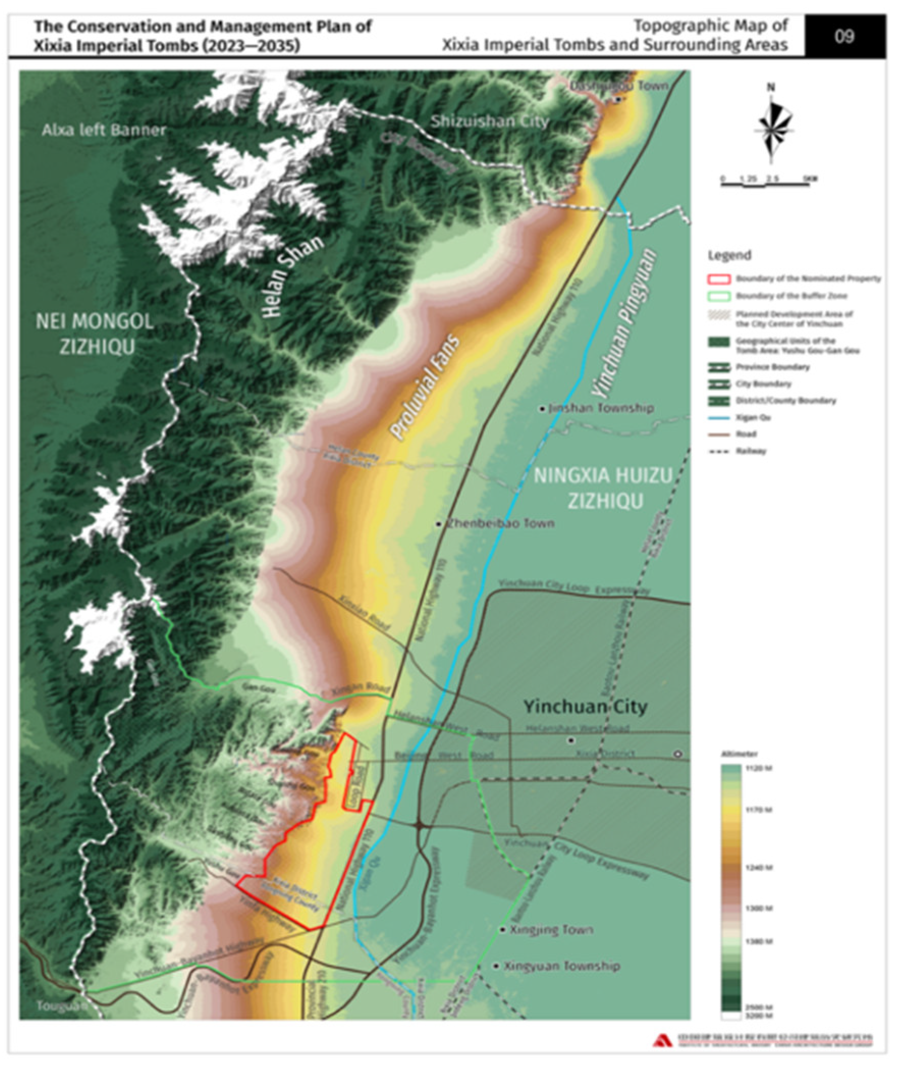
Figure 2.
The aerial view of Mausoleum No.3 at the Xixia Imperial Tombs. (Source: XIXIA IMPERIAL TOMBS, 2025).
Figure 2.
The aerial view of Mausoleum No.3 at the Xixia Imperial Tombs. (Source: XIXIA IMPERIAL TOMBS, 2025).
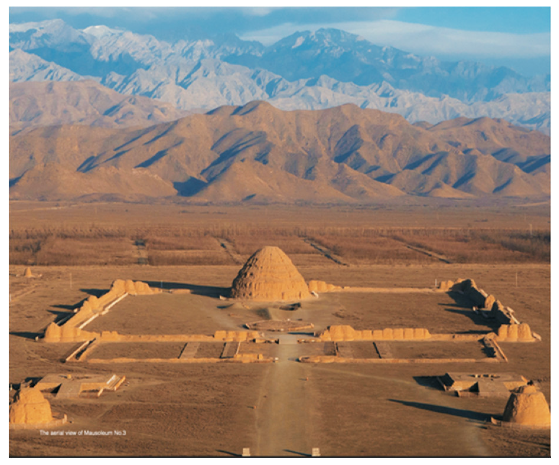
Figure 3.
Map showing the distribution of remains of Xixia Imperial Tombs. (Source: XIXIA IMPERIAL TOMBS, 2025).
Figure 3.
Map showing the distribution of remains of Xixia Imperial Tombs. (Source: XIXIA IMPERIAL TOMBS, 2025).
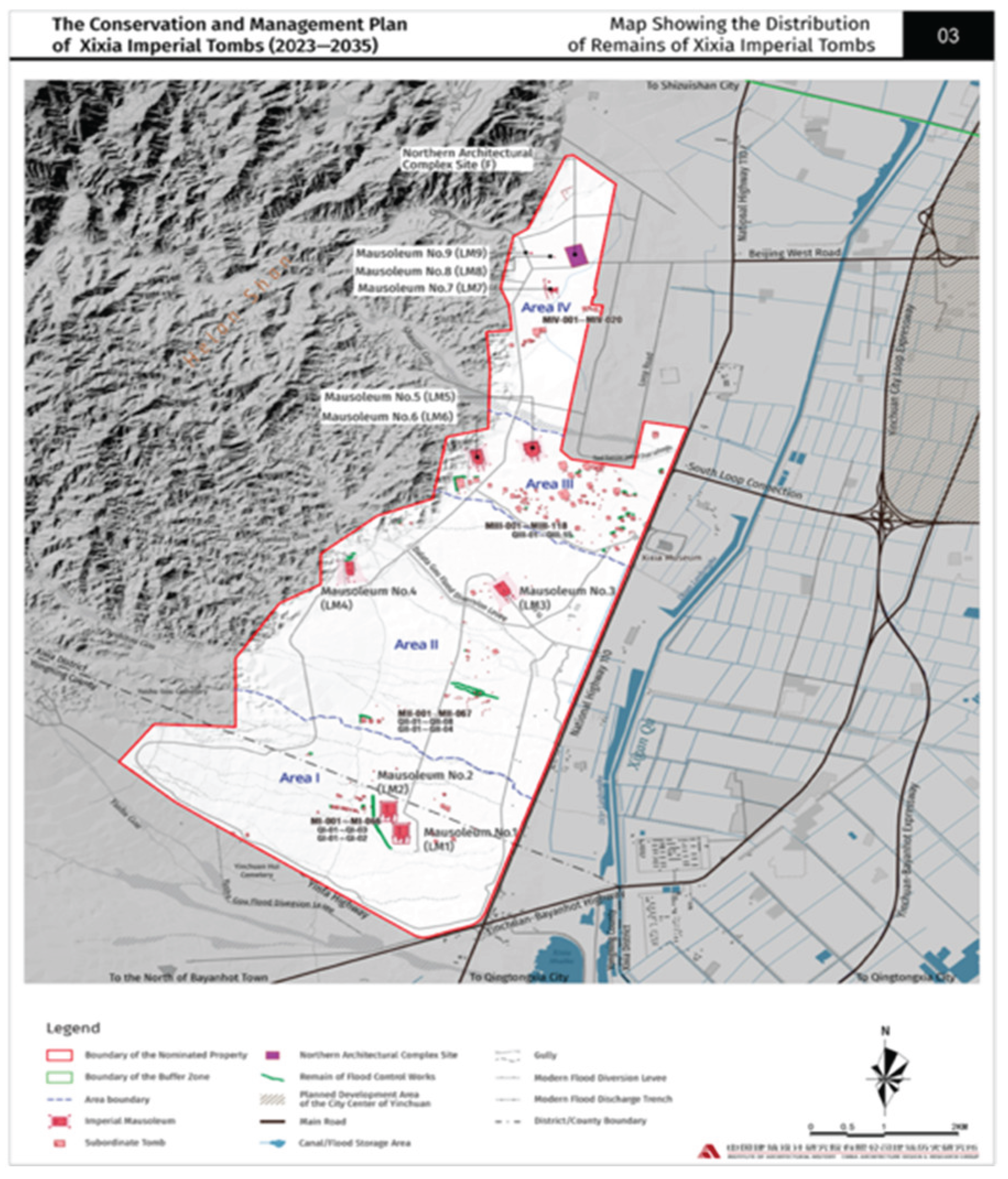
Figure 4.
(a) Overall picture of rammed earth building of No.3 Mausoleum Tower. (b) Local detail of rammed soil layer in No.3 Mausoleum. (photo by author).
Figure 4.
(a) Overall picture of rammed earth building of No.3 Mausoleum Tower. (b) Local detail of rammed soil layer in No.3 Mausoleum. (photo by author).
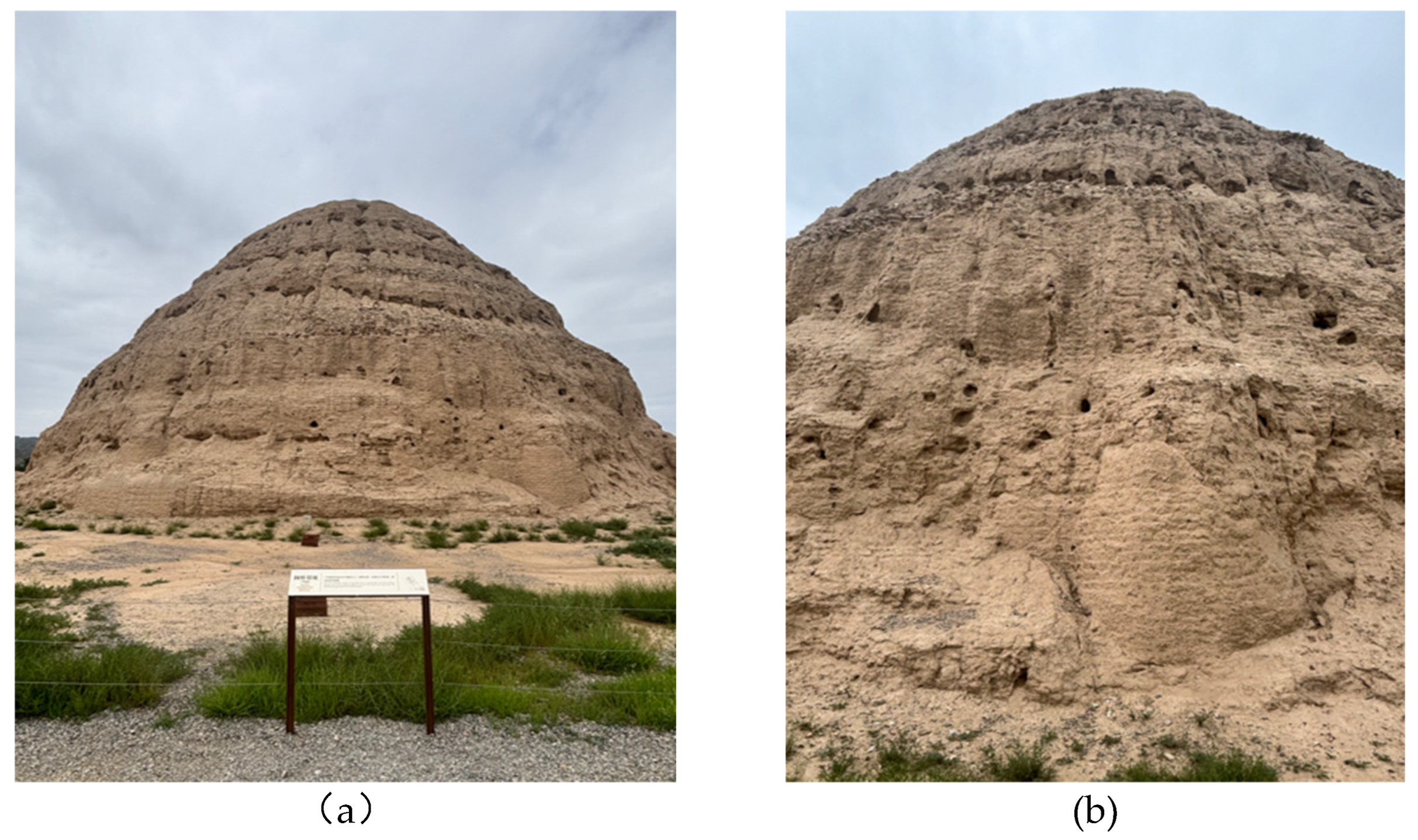
Figure 5.
Section of Original (Xixia-period) Flood Drainage Ditch at the Xixia Imperial Tombs. (Photo by author).
Figure 5.
Section of Original (Xixia-period) Flood Drainage Ditch at the Xixia Imperial Tombs. (Photo by author).
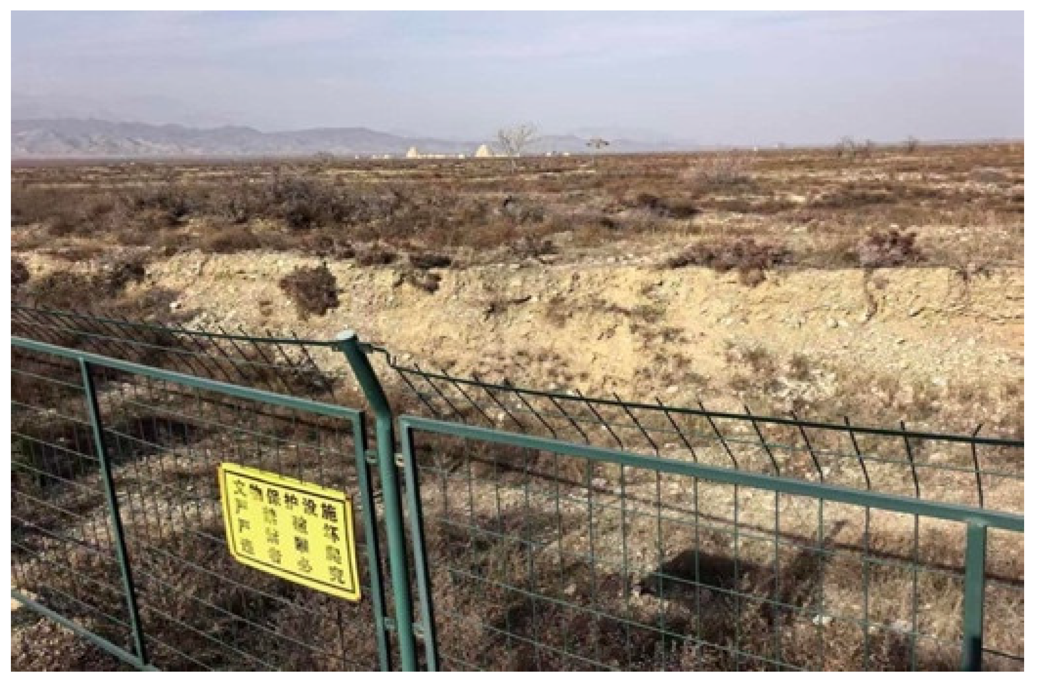
Figure 6.
Archaeological Excavation of Flood control Works Sites. (Source: Ningxia Institute of Cultural Relics and Archaeology, 2024).
Figure 6.
Archaeological Excavation of Flood control Works Sites. (Source: Ningxia Institute of Cultural Relics and Archaeology, 2024).
Disclaimer/Publisher’s Note: The statements, opinions and data contained in all publications are solely those of the individual author(s) and contributor(s) and not of MDPI and/or the editor(s). MDPI and/or the editor(s) disclaim responsibility for any injury to people or property resulting from any ideas, methods, instructions or products referred to in the content. |
© 2026 by the authors. Licensee MDPI, Basel, Switzerland. This article is an open access article distributed under the terms and conditions of the Creative Commons Attribution (CC BY) license (http://creativecommons.org/licenses/by/4.0/).
Copyright: This open access article is published under a Creative Commons CC BY 4.0 license, which permit the free download, distribution, and reuse, provided that the author and preprint are cited in any reuse.


