Submitted:
24 February 2026
Posted:
25 February 2026
You are already at the latest version
Abstract
The Santorini volcano, Greece, attracts global scientific interest and constitutes a top tourist destination. The 17th century BCE eruption, known as the Minoan event, was likely the largest ever occurred in the Holocene. The evaluation of an enriched collection of documentary sources combined with scientific observations showed that during historical times 14 small-to-moderate eruptive episodes were reported from the 2nd century BCE up to 1950 CE. Among them two little-known episodes occurring in 1667 CE and 1773 CE were uncovered and analyzed based on European documentary sources. For the first time a reliability score has been assigned to each one of the 14 episodes. The completeness of the recorded eruption history after the 14th century CE looks like ten times higher than in the previous period but it remains unclear whether this reflects real eruption rate or reporting incompleteness. The eruptions occurring after the 17th century CE are characterized by lower size, in terms of Volcanic Explosivity Index (VEI), than in the previous period. However, this may be due to the incomplete record of earlier eruptions of low VEI magnitude.
Keywords:
Santorini volcano
; Aegean Sea
; historical eruptions
; eruptions of 1667 and 1773 CE
; historical record reliability
; Volcanic Explosivity Index
1. Introduction
The Santorini volcano, south Aegean Sea, Greece (Figure 1), attracts global geoscientific interest. The 17th century BCE eruption, known as Minoan event, was likely the largest ever experienced in Holocene [1]. Geological and archaeological evidence supports that the Minoan eruption was associated with significant tephra falls, earthquakes, and tsunamis drastically influencing eastern Mediterranean civilizations [1,2,3,4,5,6]. Comparative studies indicate great similarity between Santorini and Krakatoa volcano in Sunda Strait [5], but the Minoan eruption exceeded in size the 1883 CE Krakatoa eruption.
During historical times the volcanic cycle in Santorini restarted with eruptions of small-to-moderate size and associated with magma emplacement in the caldera. In this way the so-called Kamenae (Burned) islands were shaped [2,6], exactly as happened in the Krakatoa caldera with the post-1883 generation of the Anak (Child) island. After several eruptive episodes documented from the 2nd century BCE up to the first half of the 20th century, Santorini has remained dormant since 1950.
In February-March 2025 a cluster consisting of thousands of earthquakes, with maximum magnitude 5.3 and sources located at distances of 20-40 km to the east of Santorini Island, caused extensive social anxiety but no eruptive activity was noted, e.g. [7,8].
Santorini constitutes a top tourist destination because of its unique volcanic landscape. The total number of annual visitors has been estimated to exceed three million in the last years. Therefore, the assessment and public communication of the volcanic and associated hazards in Santorini, including earthquakes, tsunamis and landslides, is a must not only for the local people but also for the visitors who arrive οn the island all year round. The recorded history of previous eruptions and the associated phenomena is one of the most important components involved in hazard assessments. However, the record of eruptions throughout the entire historical period is very likely incomplete and, in several cases, uncertain.
In this study, the historical volcanic eruptions in Santorini are re-examined based mainly on a compilation of documentary sources, which are enriched with respect to previous compilations. Two little-known episodes not listed so far, that occurred in the Santorini caldera in 1667 CE and 1773 CE, are also analyzed based on contemporary European documentary sources. In addition, published scientific observations are available for some of the eruptions examined, while a field inspection that I performed in the area offers useful insights. These scientific observations have also been considered in the present examination.
Re-examination of historical eruptions focuses for the first time on the quantification of the eruption’s reliability based on a reliability index used in the past for historical earthquakes and tsunamis. The completeness of the eruption reporting is also examined, while the eruptions sizes are estimated in terms of the Volcanic Explosivity Index (VEI) magnitude scale [9]. To better understand the phenomena described in the documentary and scientific sources, the volcanic and geographical setting of the area is first reviewed briefly.
2. Volcanic and Geographical Setting
In the Late Bronze Age era, a giant caldera-forming eruption of Plinian-type occurred in Santorini volcano at around 1613 BCE [2]. The size of the so-called Minoan eruption was estimated as high as at least VEI=7 [1] at an 8-grade scale [9]. The Santorini caldera formed after the Minoan event is of elliptical shape with diameter 11 km in the N–S direction and 7.5 km in the W–E direction [6] (Figure 1). The three islands of Santorini (or Thera), Therasia and Aspronisi, that remained after the volcanic cone collapse, surround as a ring the caldera (Figure 1). The Santorini caldera cliffs are quite steep and rise to a height of up to ~300 m above sea level although the elevation varies across the island’s edge. Tephra layers that overtop the three islands consist mainly by pumice with thickness up to ~30 m.
With the Minoan eruption a volcanic cycle was completed and a new cycle started with the occurrence of small-to-moderate eruptions in the caldera during historical times. From documentary sources it has been supported that volcanic episodes occurred in the caldera in 197 BCE, 19 CE, 46, 726, 1457 or 1458, 1572, 1707–1711 and 1866–1870 [2,6,10]. During the 20th century the eruptions of 1925–1926, 1928, 1939–1941 and 1950 are very well documented [2,6]. The volcano remains in a dormant state from February 1950 up to now.
Historical eruptions generated several new volcanic islands in the caldera. The islands existing today are the Palaia (Old) Kameni and Nea (New) Kameni. Palaia Kameni, that was likely generated by eruptions preceding the 1572 CE one, was unified with an earlier islet named Hiera (Figure 2) that probably was formed by the 197 BCE eruption. During the 1572 CE eruption lava effusions shaped the island of Mikri (Lesser) Kameni, being of ~600 m in length and of ~250 m in width in the N–S and E–W directions, respectively [11]. The eruptive activity of 1707-1711 CE generated the island of Megali (Large) Kameni between Palaia Kameni and Mikri Kameni. Megali Kameni grew up during post-1711 eruptions and eventually unified with the Mikri Kameni. In this way the Nea Kameni was created, which today constitutes the largest island existing in the caldera. A map constructed in the field and published by Olivier [12], a French diplomat who visited the Greek islands, nicely illustrate the islands existing in the caldera by the late 18th century (Figure 2). This map is consistent with the one published by Comte de Choisel-Gouffier [13] who also visited Santorini by the end of 18th century. The last map was recently republished by Papadopoulos [11].
In 1650 CE a powerful eruption, accompanied by earthquakes and tsunamis [2,6,14,15], occurred at the Kolumbo polygenetic submarine volcano, situated about 15 km from the centre of Santorini’s caldera to the NE direction (Figure 1).
From the geographical point of view, of special interest to our investigation are the historical settlements of Apanomeria, modern Oia, which is situated at the northern side of Santorini Island, as well as of the medieval town in the Castle of Skaros at the south of Apanomeria (Figure 2).
3. Research Methods and Information Sources
3.1. Research Methods
The post-Minoan eruptive history in the Santorini island complex is documented by a variety of documentary sources. To re-examine the Santorini eruption history, I collected a set of classical texts, books, articles, letters, travelogues, maps, newspaper reports and eyewitnesses accounts for the eruptions that occurred before the 20th century. Collections and quotations of such documentary sources can be found in several publications of modern authors [2,6,10,15,16,17,18,19]. I also examined little-known documents referring to two episodes occurring in 1667 CE and 1773 CE, which have not been considered so far in the volcanological tradition. The eruptions occurring during the 20th century are very well documented by a series of scientific publications and, therefore, they were briefly reviewed.
One important issue is the incompleteness of the volcanic record before the 20th century as the gradual reveal of new documentary sources indicates. The documents about the episodes of 1667 CE and 1773 CE examined in this paper constitute an example. Another example regards the volcanic episode that supposedly occurred in 1570 or in 1573 CE, which was re-examined very recently by Papadopoulos (2025) [11] based on a little-known manuscript. The examination of this document not only showed that the eruption occurred in 1572 CE but also helped in better understanding the explosivity and duration of the eruption as well as the impacts on the people and cultivation in Santorini.
Of importance is also the reliability of the documentary sources. For example, contradictory information is frequently provided by different sources referring to a single eruptive episode. This is an issue well known from historical seismicity studies. In addition, some sources cast doubts whether a reported episode was really an eruption or not. On the other hand, one should carefully discriminate between original documents based on eyewitnesses’ accounts and second-hand sources produced by authors who recollected material from previous sources. Important lessons about this issue have also been learnt from the study of historical earthquakes, e.g. [20]. In the last years, our knowledge about some historical eruptions in Santorini were complemented by scientific observations which are helpful in better understanding at least two eruption episodes [21,22]. A field inspection that I performed in the island of Palaia Kameni proved also helpful for the examination of the questionable eruption of 1457 CE.
The documentary sources compiled were critically evaluated and cross-checked as for their completeness and reliability. Based on the evaluation’s findings a supposed eruptive episode was characterized by a reliability score, R, as if it was a real eruption or not. The assignment of R has been done on a 4-degree reliability scale applied in the past for the reliability characterization of historical earthquakes and tsunamis in Japan and in the Mediterranean region [23,24,25,26]. The reliability scale ranges from improbable (R=1) to questionable (R=2), probable (R=3) and definite (R=4). Although such a characterization is susceptible to subjectivity it has been done based on the next criteria: (1) a single source referring to a single eruption is considered as less reliable than a set of more than one sources which are consistent but independent each other; (2) consistency of a source’s content with the volcanological, chronological and geographical contexts of the area, increases reliability; (3) reliability increases also if the content of a documentary source is supported by scientific observations.
The VEI magnitude of an eruption was assigned according to the 8-grade scale introduced by Newhall and Self (1982) [9]. To such assignments I considered the documentary and scientific material collected as well as the VEI assignments to Santorini eruptions that can be found in the Global Volcanism Program [27] (https://volcano.si.edu/volcano.cfm?vn=212040; last access 9 February 2026) and in other studies, e.g. [15,21,28]. The VEI estimation of an eruption is based on the ejecta volume, plume height and duration of the main eruptive phase. Secondary criteria may include the eruption type, e.g., Plinian, Strombolian etc., as well as eruption characterizations like small, large etc. A routine practice followed by previous authors has been to assign a single VEI value to a single eruption. However, because of the many uncertainties involved in the sources examined, I preferred to estimate the VEI of an eruption not as a single value but as the possibility of two consecutive values, i.e. either VEI or VEI+1, e.g. 3 or 4, conventionally written as 3-4. For the 20th century eruptions, the VEIs provided by the Global Volcanism Program [27] were adopted.
3.2. Information Sources
3.2.1. Historical Eruptions
In the next lines original and second-hand documentary sources referring to the Santorini volcanic eruptions occurring before the 20th century are examined and cross-checked. The examination of some eruption cases is supported by scientific observations which have also been considered. The examination proceeds in chronological order. Dates after the 16th century CE are according to the New Style (N.S., Gregorian) calendar unless otherwise indicated, e.g., the Old Style (O.S., Julian) calendar. Excerpts of documentary sources have been inserted, if needed, as short explanations in the form [explanation].
197/196 BCE
The earlier source for this eruption is a set of various fragments of the ancient Greek writer Posidonius (135 BCE-51 CE). These fragments survived through subsequent classic authors including Strabo and Seneca, while Pliny the elder, Plutarch and Justinus, provided relevant information. Summarizing those authors, we may conclude that an eruption occurred between Thera and Therasia during the fourth year of the 145th Olympiad, i.e. during 197/196 BCE. Fires broke from the sea and lasted for four days, so that the entire sea boiled and brazed. An island with an estimated circumference of about 2 km emerged from the sea as if by burning materials. Several sources confirmed that this island was called Hiera-The Holy- and was likely the first shaped in the caldera after the Minoan eruption (Figure 2).
19 CE
Pliny the elder reported that an island called Thia (Theia)-The Godly- appeared in the neighbourhood of Hiera in the year 19 CE [2,6]. However, this is not mentioned by other sources and very probably is based on a transcription error [2]. For this reason, the 19 CE eruption has been considered as a discredited event [2,27].
46 July 6
This eruption was reported by several authors including Seneca, Dio Cassius and Aurelius Victor. Correlation with historical events leads to date the eruption in 46 CE. Further correlation with a moon eclipse makes 6 July 46 CE as the most likely eruption date [19]. During this eruption the island of Thia very likely was born with a circumference of about 5.6 km. Fouqué (1879) [29] suggested that Thia is the present Palaia Kameni and that Hiera is the shallow Banco, which at that time emerged above sea level, but afterwards disappeared.
In a passage of his book Life of Apollonius of Tyana, Flavius Philostratus writes that while Apollonius was at Leben, a port situated on the southern coast of Crete, an earthquake occurred, which was accompanied by sea retreat. In his narration he goes on to say [17]): …but a few days later some travellers arrived from Cydonia [modern Chania in NW Crete] and announced that on the very day on which this portent occurred and just at the same hour of midday, an island rose out of the sea in the firth between Thera and Crete. After careful inspection and review of many documentary sources and geological evidence, Papadopoulos (2011) [26] concluded that there was a strong tsunamigenic earthquake of tectonic origin that very likely occurred around 66 (±1 year) CE in southwest Crete having no association to activity in Santorini volcano.
725/726
A new eruption between Thera and Therasia was reported by Byzantine authors, like Theophanes (752-818), Patriarch Nicephoros (758-823) and Cedrenos (11th century), as well as by Michael the Syrian (1126–1199), Patriarch of Syria [2,6,19,30]. From the evaluation of these sources, it comes out that the eruption occurred in the year a.M. (Anno Mundi) 6218, i.e. between September 725 CE and August 726 CE. The ejected lava likely resulted in the enlargement of the island of Hiera. The paroxysm lasted about three days, but the eruptive episode continued perhaps for more than a month. A great quantity of pumice erupted and transported by the sea over a large area, reaching coastal sites in the North Aegean Sea, like Lesvos Island, Avydos near Dardanelles, and the coasts of Asia Minor and Macedonia. We may add the island of Samothraki where pumice was also observed in coastal sites [31].
Valuable results about this eruption were obtained by Preine et al. (2024) [21] based on high-resolution seismic reflection data with cored lithologies at four sites. Their shore-crossing analysis revealed the deposits of a submarine explosive eruption that produced up to 3.1 km3 of pumice and ash, which they related to the historical eruption in 726 CE. VEI=5 was estimated by Preine et al. (2024) [21] but the Global Volcanism Program [27] assigned VEI=4(?).
1457 November 25
An eruption likely occurred in the Santorini caldera, although the available documents do not help clearly understand what exactly happened. First evidence comes from the Latin text on an inscription carved beside the portal of Skaros castle [2,19,32,33,34]. The text says that the event happened on the 25th of November 1457. The translation of the rest part of the Latin text reads as next [2]: …with a great rumble, immense Thererinus [the sea around Therasia] tore enormous rocks from Kameni, and with a groan, a crag appeared from the depths of the waves bringing with it a great and memorable portent. A similar translation was adopted by Ambraseys [19] who dated the event on 25 November 1455. Friedrich [2] noted that this text is unclear but seems to state that an island either disappeared or appeared at that time.
The Florentine monk Cristoforo Buondelmonte travelled in Greek islands from 1414 to 1420 CE. Around 1420 CE he circulated his first travelogue manuscript titled Liber Insularum Archipelagi [32]. Maps of several islands, including Thera and Therasia, were also included in the travelogue. A later version of the manuscript, dated from the year 1465 to 1466 CE, contains the same schematic drawing of Thera and Therasia plus a short text saying that eight years earlier, i.e. in 1457 or 1458 CE, an island appeared there [32]. The length of the island was equal to that of one galley, i.e. of ~160 m. It is not clear if the short text was added by Buondelmonte himself or by one of the manuscript editors. In any case, we may not exclude that the text added in the map was based on the Latin text carved beside the portal of Skaros.
The emergence of an island is referred to by Suriano [18], a Venetian nobleman and traveler who writes that: …The following year [1463] in the archipelago, there was such a terrible earthquake that the islands of Chio [perhaps Scio=Ios] and Santorini and nearby islands shook so much that they could not remain standing; and the islanders say that they thought it was the end of the world. And in the morning, they saw that an island five miles long had been created nearby, and they called it Chaimeni [Kameni]. Ambraseys [19] believes that this episode is a duplication of the volcanic activity that according to his opinion occurred in 1455 CE. However, the reported length of five miles of the emerging island is very likely an exaggeration if not completely erroneous.
In his pilgrimage to Jerusalem, the Catholic nobleman Pietro Casola from Italy (1427–1507), narrates that [18]…very late on Saturday, the 27th of September [1494], the captain [of the galley] would gladly have approached an island called Santurin. And there was a great dispute in consequence between the captain and the comito and the pilot, who said to the captain that it was not a suitable place to stop at—that is, to cast the anchor. The next paragraph of Casola’s narration is of particular interest to the examination of the 1457 eruption:…The captain maintained that on other occasions he had anchored there; and he related that one time when he was in the Canal of Santurin with several galleys, a storm arose in the West which continued for the space of three days, and was not only violent but very terrible—great thunder, great flashes of lightning, and noises as if there had been battle chargers there; and all on board the galleys were so terrified that they did not know what world they were in. On the morning of the third day an island as black as coal made its appearance; and the aforesaid captain said that they made every effort to approach it, but could never discover the bottom, and that he had never been able to anchor there since.
The last passage implies that in some unidentified time before 1494 a black island emerged likely at the west side of the caldera, i.e. near the place of Palaia Kameni. This event was preceded by three days of great thunder, flashes of lightning, and noises. The captain’s narration makes no clear whether an eruption occurred or a rock reef broke away from the cliffs of Palea Kameni, which is one of the possibilities discussed by Friedrich [2]. The significant time distance of 37 years between the event of 1457 CE and 1494 CE makes it hard to correlate the island in the captain’s narration with the one that supposedly emerged in 1457 CE, although one may not rule such a possibility.
The story about the possible eruption occurring in 1457 CE is further complicated by the presence of a conspicuous rock failure on the northeastern side of Palaia Kameni. This is a fault scarp or rock detachment as illustrated in Figure 3 taken during my field inspection on the island. One gets the impression that Palaia Kameni is the remaining of an island, the other part of which disappeared into the sea. However, the causative mechanism remains unknown. One possibility is that the rock failure was caused by dynamic shaking during an earthquake or a volcanic eruption.
Another explanation could be that a gravitative landslide of a fractured rock mass was produced without shaking. This scenario excludes the possibility of an eruption even of small size. There is no evidence about the event dating, although it looks like that happened in historical times. According to Friedrich [2], a possibility would be that Palaia Kameni appeared in 1457 CE rather than in 726 CE and was enlarged by the younger blocky lava now seen on the flatter part of the island. Then, the occurrence of a possible eruption is assumed, and the rock failure could have happened during that eruption in spite of the fact that this episode is not included in the list of the Global Volcanism Program [27].
1572 spring-summer
Regarding this eruption, until recently only little information was recollected from local memory and it was considered occurring either in 1570 or in 1573 or from 1570 to 1573 CE [33,34]. Papadopoulos (2025) [11] brought to light a very little-known but reliable manuscript of a Greek traveler, which is dated in 1588 CE, and reveals that the eruption occurred in 1572 CE between Santorini Island and Palaia Kameni. The manuscript makes clear that “fire, smoke, and stones” were coming out between the two islands and a new volcanic island named Mikri Kameni -The Lesser- was born (Figure 2).
According to the manuscript, the floating pumice was transported by the sea as far as to Thessaloniki and Constantinople, resembling pumice transportation in the North Aegean Sea after the 725/726 CE eruption. Smoke and heat destroyed the vineyards and the planting on Santorini, which implies that very likely the eruption occurred in spring-summer season. Residents of Santorini were forced to move to nearby islands very likely because of sulfurous gases released. The duration of the eruption was estimated at ~1yr but the fire and smoke disappeared suddenly.
1650 October 9
Kolumbo is a submarine polygenetic volcano situated off northern Santorini Island (Figure 1). The only known historical eruption occurred at the central Kolumbo volcano during 1650 CE. The eruption and its associated phenomena are documented by many original information sources [2,6,14,15,16,19,26].
From the documentary sources available we learn that intense seismic activity was noted from March 1650 CE, but the eruption occurred from September to December with the paroxysmal phase taking place on 29 September (O.S.)/9 October (N.S.) with a likely Plinian-style rhyolitic explosive eruption. The eruption was accompanied by important phenomena such as damaging earthquakes, tephra falls, deadly gas discharge and a powerful tsunami that hit violently Santorini, nearby islands and north Crete. It has been estimated that about 50 deaths were caused in Santorini, nearly all due to suffocation caused by the release of poisonous gases very likely containing H2S. The Global Volcanism Program [27] assigned VEI=4(?) but VEI=5 was estimated by others [15].
1667 February
Monsignor Giuseppe di Santa Maria Sebastiani was a Carmelite monk who traveled around with Italian missions in the Greek islands in 1666-1667 CE and published an extensive travelogue [35]. Although the travelogue chronology is not detailed, I was able to identify that Sebastiani arrived on the island of Syros on the 19th of January 1667. By the beginning of February, he sailed from the island of Ios to Santorini. Although his destination was the Castle of Skaros, he disembarked along with his company at Santorini’s headland called Apanomeria (Figure 2), modern Oia, at the northern side of Santorini Island.
The narration of Sebastiani goes on as follows: We landed with our belongings. The shore at that point was all sand and flat but no wider than 10 yards [I assume it was the small bay today called Ammoudi, Figure 3]. From it rise very high rocks, so high a straight that they look like built with plumb lines. While we were making a little collection, near a small opening in the middle of the height of the said rocks, a whirlwind or rather a furious wind came from a small mouth in the middle of the height of the said rocks, which vomited upon us a great quantity of white pumice stones. It stopped suddenly and after some time it made the same indentation and did the third time to our amazement and fear and it increased even more when in a time that when no light breeze was blowing, we saw the sand moving on that perfectly flat shore. However, we intended to leave that island. And a small boat came to use from a village called St. Nicolas [very likely situated in Apanomeria].
Sebastiani’s narration is not clear as for the nature of the phenomenon described. Was it a gas discharge along with pumice material from an opening at the caldera cliff? One may not exclude the occurrence of a local landslide in three sequential episodes. Ambraseys (2009) [19] suggested that it was a minor eruption together with what may have been a slight earthquake. Then, may not rule out the occurrence of a phreatic eruption. However, one may wonder if it is possible for an even small eruption to occur at the caldera cliffs.
1707 May-1711 September
The series of eruptions, which started in May 1707 and lasted until September 1711, are well documented. Detailed descriptions can be found in the publications by the eyewitnesses Jesuit Fathers Goree (1712) [36] and Turillon (1714) [37] as well as by the traveler Aubry de la Motraye’s (1723) [38]. A relevant map of the Santorini island complex (Figure 4), which is included in the publication by Father Goree (1712) [36] is helpful to better understand the evolution of this eruptive episode.
The testimonies about this eruption phase are summarized as follows. By the end of May 1707, a White island (Figure 4) consisting of pumice and some black lavas was seen uplifting to the west of Mikri Kameni. On the 5th of June fire was set, and a new Black island was formed north of the island of white pumice (Figure 4). By September 1707 the Black island was so large that it united with the White one; in this way the island of Nea Kameni was born. Explosions and ash eruptions continued until September 1711. Ross (1840) [30], who visited Santorini in 1836 and 1839 noted that fishermen had observed that not far from Nea Kameni a sharp reef had started to rise from the sea and grows more every year.
1773 January 10
A correspondence of the Spanish newspaper El Mercurio Histórico y Político (1773) [40] says that: From a ship which left the Archipelago we learn that on Santorini and in adjacent islands, on 10 January of this year [1773], an earthquake was felt, accompanied by a low but continuous roar, and whirlwinds of smoke and flames. When this calmed down, it was noticed that the lands of Santorini had extended around half a mile northward. Between this island and Megali [the Grand], a strait was formed, which could provide a new route for ships to enter and leave the port of Santorini.
This is a puzzling description which needs authentication [19]. According to the press correspondence, three main phenomena occurred on that date: (i) an earthquake that was presumably strong enough because it was felt not only in Santorini but also in other islands; (ii) accompanying roar, whirlwinds of smoke and flames, which imply the possible occurrence of an eruption; (iii) the lands of Santorini were extended half a mile northward, indicating the generation of a new island close to Megali, which was a predecessor of Nea Kameni.
But what was the new island that reportedly emerged in 1773? To respond to that question, we should have a clear picture of the landscape in the caldera after the supposed eruption of 1773. To this aim I considered detailed maps prepared in the field after 1773 and published a few years later. The first map, that was prepared by Comte de Choisel-Gouffier [13] and re-published recently [11], illustrates three islands existing in the caldera: (1) Grande Cameni-anciennem Hiera (Large Kameni-ancient Hiera), i.e. the Palaia Kameni, (2) Petite Cameni (Lesser or Mikri Kameni), and (3) L’ Ile Nouvelle (New Island or Nea Kameni). Similar is the landscape in the caldera illustrated in the map (Figure 2) published by Olivier [12] who traveled in Greek islands by the end of the 18th century. It is noticeable that Mikri Kameni was a smaller island that was generated by the 1572 eruption [11], while Nea Kameni was born nearby during the 1707-1711 eruption as described by eyewitnesses. According to the Spanish correspondence a strait was formed between the new island and Megali (Nea Kammeni). Bearing in mind the landscape illustrated in contemporary maps mentioned earlier, a realistic suggestion would be that the island that appeared during the 1773 episode could be a northward extension of Mikri Kameni. This is consistent with the narration that a strait was formed between the new island and Megali. That the lands were reportedly extended half a mile northward may imply lava flow to that direction.
Although the newspaper report has not been verified by other documentary sources, my explanation is supported by the results of an investigation with a high-resolution merged LiDAR-bathymetry grid [22]. This enabled detailed mapping of both onshore and offshore historical lava flows of the Kameni islands, allowing the identification of new submarine lava flows. One of them, which is located north of Nea Kameni, appears to predate the 1925–1928 lava flows but was emplaced after the 1707–1711 lava flows. I suggest that the extension of lands northwards, that reportedly happened very likely at Mikri Kameni, could be the new lava flow mapped with LiDAR bathymetry techniques.
1866 January-1870 October
This eruption phase is very well documented because of the existence of many detailed eyewitness accounts, field observations, photos and drawings collected and published by many authors. Compilations of relevant documents can be found in several review publications [2,6,29].
Volcanic activity started at the end of January and the beginning of February 1866 with submarine effusion of lava. Explosions started a few days later. The volcanic activity continued with effusive and explosive episodes up to 15 October 1870. During this period several volcanic centers and domes were generated, thus increasing the size of the Nea Kameni Island [2,6]. After the end of the eruptions the activity remained at a solfataric stage.
3.2.2. Eruptions During the 20th Century
Four main eruption phases occurred during the 20th century, all taking place in Nea Kameni and between this island and Mikri Kameni. Many scientific publications and documentation by photos are available. Details about the eruptions and relevant references can be found in review publications [2,6,16].
1925 August-1926 January
This eruption phase started on 11 August 1925. After numerous explosions and submarine effusion of lava, the Mikri Kameni and Nea Kameni united on 12 August 1925. The activity lasted until mid-January 1926.
1928 January-March
After the rest of 20 months a new activity phase started on 23 January and ended on 17 March 1928. Several explosions were accompanied by the effusion of lava, and a new small dome was created. Solfataric activity followed until the next phase.
1939 August-1941 July
This eruption phase was subdivided into five episodes with eruptions, effusions and generation of new small domes. The activity started on 20 August 1939 and ended in the first days of July 1941.
1950 January-February
An epigenetic eruption began on 10 January 1950. The activity lasted only 24 days, i.e. until 2 February, with explosions accompanied by effusions and the formation of a small dome. Afterwards the volcano got in a stage of solfataric and fumarolic activity, which lasts until now.
4. Results
The examination of many documentary sources and scientific observations indicates that after the giant pre-historic Minoan eruption, a series of 14 historical eruptions occurred in the Santorini island complex. The recorded eruption history covers the time span from 197/196 BCE up to the present. No evidence has been found for historical eruptions occurring before 197/196 BCE. Table 1 lists dates, reliability, VEI and main volcanic landscape changes associated with the 14 eruptions. The eruption that allegedly occurred in 19 CE is not included in the list of Table 1 because it is discredited for reasons analyzed earlier.
Table 1 indicates that the completeness of the eruption historical record is doubtful. From 1457 CE up to the present the recorded eruption rate is ~2 eruptions/century, which looks like more complete as compared to the pre-1457 time interval. To estimate the recorded eruption rate for the pre-1457 CE time interval, I considered that the historical period counts from around 500 BCE when the historical earthquake record in Greece started. Then, the pre-1457 CE rate of eruption record was found ~0.2 eruptions/century. However, it remains questionable if this very low eruption rate is true or reflects an artificial result because of record incompleteness. It is of interest that incompleteness before the 16th century CE has also been noted in the recorded history of earthquakes and tsunamis in Greece [40].
5. Conclusions
The evaluation of an enriched compilation of many historical documents and scientific sources showed that 14 eruption episodes have been recorded in the Santorini island complex in the historical period: 197/196 BCE, 46 CE, 725/726, 1457, 1572, 1650, 1667, 1707–1711, 1773, 1866–1870, 1925–1926, 1928, 1939–1941 and 1950. The two episodes of 1667 and 1773 remained little-known so far and are added in the list for the first time. From 1457 CE onwards the eruption record looks like more complete as compared to the pre-1457 time interval which is likely due to lack of documentary evidence.
The eruptions examined are characterized by reliability ranging from 2 to 4 in a reliability scale from minimum 1 to maximum 4. The size assigned to the eruptions, in terms of the 8-grade scale of Volcanic Explocivity Index (VEI) magnitude, ranges from VEI=2-3 at minimum to VEI=4-5 at maximum. At all indications the largest eruptions in the entire historical period were those of 725/726 CE in the caldera and of 1650 CE in the submarine Kolumbo volcano. However, eruptions of lower size have systematically reported after 1650 CE. This is, however, a challenging point in the sense that low magnitude eruptions perhaps escaped recording before the 15th or 16th centuries.
Funding
This research received no external funding.
Institutional Review Board Statement
Not applicable.
Informed Consent Statement
Not applicable.
Data Availability Statement
All data sources are reported in the text.
Acknowledgments
Figure 1 was constructed with the use of GMT 5 software [41].
Conflicts of Interest
The author declares no conflict of interest.
References
- Johnston, E.N.; Sparks, R.S.J.; Phillips, J.C.; Carey, S. Revised estimates for the volume of the Late Bronze Age Minoan eruption, Santorini, Greece. Journal of the Geological Society 2014, 171(4), 583–590. [CrossRef]
- Friedrich, W.L. Fire in the Sea. Cambridge University Press, 2000, UK, 258 pp.
- Novikova, T., Papadopoulos, G.A., McCoy, F.W. Modeling of Tsunami Generated by the Giant Late Bronze Age Eruption of Thera, South Aegean Sea, Greece. Geophys. J. Int. 2011. [CrossRef]
- Athanassas, C.D.; Modis, K.; Alçiçek, M. C.; Theodorakopoulou, K. Contouring the Cataclysm: A Geographical Analysis of the Effects of the Minoan Eruption of the Santorini Volcano. Environmental Archaeology 2018, 23(2), 160–176. [CrossRef]
- Hédervári, P. Some comparisons between Santorini and Krakatau volcanoes. In: S.S. Augustithis (Ed.), International Congress on Thermal Waters, Geothermal Energy & Vulcanism of the Mediterranean area, Athens, October 1976, 3, 63-75.
- Georgalas, G.C. Catalogue of the active volcanoes of the world including solfatara fields, Part X, Greece. Int. Assoc. of Volcanology 1962, 1-40.
- Triantafyllou, I.; Papadopoulos, G.A.; Siettos, C.; Spiliotis, K. Real-Time Foreshock–Aftershock–Swarm Discrimination During the 2025 Seismic Crisis near Santorini Volcano, Greece: Earthquake Statistics and Complex Networks. Geosciences 2025, 15, 300. [CrossRef]
- Briole, P.; Ganas, A.; Serpetsidaki, A.; Beauducel, F.; Sakkas, V.; Tsironi, V.; Elias, P. Volcano-tectonic interaction at Santorini. The crisis of February 2025. Constraints from geodesy, Geophys. J. Internat. 2025, 242(3). [CrossRef]
- Newhall, C. G.; Self, S. The volcanic explosivity index (VEI): an estimate of explosive magnitude for historical volcanism. J. Geophys. Res. 1982, 87(C2), 1231–1238. [CrossRef]
- Bocchini, G.M.; Brüstle, A.; Becker, D.; Meier, T.; van Keken, P.E.; Ruscic, M.; Papadopoulos, G.A.; Rische, M.; Friederich, W. Tearing, segmentation, and backstepping subduction in the Aegean: New insights from seismicity. Tectonophysics 2018, 734–735, 96–118.
- Papadopoulos, G.A. The 1572 CE Santorini Eruption from Little-Known Historical Documents. GeoHazards 2025, 6, 76. [CrossRef]
- Olivier, G.A., 1801. Travels in the Ottoman Empire, Egypt, and Persia. Translated from the French, Printed for T.N. Longman & O. Rees, v. II, London, 252 pp.
- Comte de Choisel-Gouffier, M. Voyage pittoresque de la Grèce. 1782. v.1, Paris.
- Dominey-Howes, D.T.M.; Papadopoulos, G.A.; Dawson, A.G. Geological and historical investigation of the 1650 Mt. Columbo (Thera Island) eruption and tsunami, Aegean Sea, Greece. Nat Hazards 2000, 21, 83-96.
- Tadini, A.; Cerminara, M.; Paris, R. et al. Scenario-based tsunami hazard assessment at Kolumbo submarine volcano. Bul.l Volcanol. 2025, 87, 52. [CrossRef]
- Fytikas, M.; Kolios, N.; Vougioukalakis, G. Post Minoan volcanic activity of the Santorini volcano. Volcanic hazard end risk. Forecasting possibilities. In: Hardy D.A. (ed). Thera and the AEGEAN World III, 1990, 2, 183–198.
- Guidoboni, E., Comastri, A., Traina, G., 1994. Catalogue of ancient earthquakes in the Mediterranean area up to the 10th century. Storia Geofisica Ambiente, Bologna, 504 pp.
- Guidoboni, E., Comastri, A., 2005. Catalogue of earthquakes and tsunamis in the Mediterranean area, 11th - 15th century. Istituto Nazionale di Geofisica e Vulcanologia, Rome, 1037 pp.
- Ambraseys, N.N. Earthquakes in the Mediterranean and Middle East, A Multidisciplinary Study of Seismicity up to 1900; Cambridge University Press, 2009, Cambridge, UK, 947 pp.
- Triantafyllou, I. Revision of the Allegedly Deadly and Tsunamigenic 1843 Earthquake at Chalke Island, South Aegean Sea, Greece. Seismol. Res. Lett. 2026, 20, 1–10. [CrossRef]
- Preine, J., Karstens, J., Hübscher, C., et al. Hazardous explosive eruptions of a recharging multi-cyclic island arc caldera. Nat. Geosci. 2024, 17, 323–331. [CrossRef]
- Nomikou, P.; Parks, M.M.; Papanikolaou, D.; Pyle, D.M.; Mather, T.A.; Carey, S.; Watts, A.B.; Paulatto, M.; Kalnins, M.L.; Livanos, I., et al. The emergence and growth of a submarine volcano: The Kameni islands, Santorini (Greece). Geo. Res. J., 2014, 1–2, 8-18. [CrossRef]
- Iida, K. Catalog of tsunamis in Japan and its Neighbouring Countries, Department of Civil Engineering, Aichi Institute of Technology. 1984, Japan, 52 pp.
- Tinti, S.; Maramai, A. Catalogue of tsunamis generated in Italy and in Cote d’Azur, France: a step towards a unified catalogue of tsunamis in Europe. Ann. di Geofisica, 1996, 39, 1253–1299.
- Papadopoulos, G.A. Tsunami hazard in the Eastern Mediterranean: strong earthquakes and tsunamis in the Corinth Gulf, Central Greece. Natural Hazards 2003, 29, 437-464.
- Papadopoulos, G.A. A Seismic History of Crete-The Hellenic Arc and Trench: Earthquakes and Tsunamis, 2000 BC-AD 2011. 2011, Ocelotos Publications, Athens, 415 pp.
- Global Volcanism Program. Department of Mineral Sciences, National Museum of Natural History, Smithsonian Institution, https://volcano.si.edu/.
- Papadopoulos, G.A.; Orfanogiannaki, K. Long-term prediction of the next eruption in Thera Volcano from conditional probability estimates. In: M. Fytikas & G.E. Vougioukalakis (Eds.), The South Aegean Active Volcanic Arc: Present Knowledge and Future Perspectives, Elsevier Book Series. Developments in Volcanology 2005, 7, 211-216.
- Fouqué, F. Santorin et ses éruptions. Masson & Cie, 1879, Paris.
- Ross, L. Reisen auf den griechischen Inseln des ägäiachen Meeres. 1840, v.1, Stuttgart.
- Christomanos, A.Κ. The island of Samothraki and the earthquake of 28 January/9 February 1893. Parnassos 1899, 193-237, Athens (in Greek).
- Hiller von Gaertringen, F. Die Insel Thera in Altertum und Gegenwart. 1899, Reimer Verlag, Berlin 537 pp.
- Richard, F. Relation de ce qui s’est passé de plus remarquable a Sant-Erini isle de l’Archipel, Depuis l’établissement des Peres de la Compagnie de Jesus en icelle. Avec la declaration de plusieurs choses memorables touchant le rit et la creance des Grecs de ce temps, et touchant les feux sous-terrains qui sortirent du fond de la mer l’an 1650 avec plusieurs prodigies. 1657, XXVI, 408–426, Paris.
- Kircher, A. Mundus subterraneus. J. Jansson and E. Weyerstraet, 1665, Amsterdam.
- Sebastiani, F. Giuseppe di S. Maria. Viaggio, e nauigatione di monsignor dell’ordine de’Carmelitani Scalzi: nell’andare, tornare dall’ archipelago. 1687, Domenico Ant. Ercole, Rome, 152 p.
- Goree, Father. A relation of a new island, which was raised up from the bottom of the sea, on the 23rd of May 1707in the Bay of Santorini, in the archipelago. Philos. Trans. 1712, 27, 354-375.
- Tarillon, Father. Lettres Édifiantes Et Curieuses: Écrites Des Missions. 1714, 1, Lyon, 507pp.
- Aubry de la Motraye. Travels through Europe, Asia, and into part of Africa; with proper Cutts and maps. Containing a great variety of geographical, topographical, and political observations. 1723, 1, London, 440 pp.
- El Mercurio Histórico y Político. April 1773, 311 pp.
- Papadopoulos, G.A. Statistics of historical earthquakes and associated phenomena in the Aegean and surrounding regions. In: P. Marinos & G. Koukis (Eds.), Proc. Intern. Symp. on Engin. Geology as Related to the Study, Preservation & Protection of Ancient Works, Monuments & Historical Sites, Athens, Sept., Balkema, 1988, 3, 1279-1283.
- Wessel, P., Smith, W. H. F., Scharroo, R., Luis, J., & Wobbe, F. GMT 5: Generic Mapping Tools: Improved Version Released. EOS, Transactions American Geophysical Union 2013, 94(45), 409–410. [CrossRef]
Figure 1.
(a) Geodynamic setting of the broad Aegean Sea region. The Mediterranean or Nubian lithosphere moves from about SW to NE and subducts beneath the Aegean Sea at the southern Eurasian plate margin along the Hellenic Trench system, e.g., [10]; PTT, PLT and ST represent the Ptolemy, Pliny and Strabo trenches, respectively. Arrows show the directions of lithospheric plate motions. There are five main volcanic centers (triangles) situated along the South Aegean Volcanic Arc above the seismic isodepth of ~150 km: Methana (Me), Milos (Mi), Thera or Santorini (Th), Nisyros (Ni) and Kolumbo (for the last, see the position in Figure 1b). Box illustrates the study area shown in (b). To the northeast of Santorini, the 9 July 1956 large tectonic earthquake of Mw=7.7 ruptured the submarine trough between the islands of Amorgos (Am) and Astypalaia (As). (b) Volcanotectonic sketch map in Santorini volcano. Figure redrafted from [11].
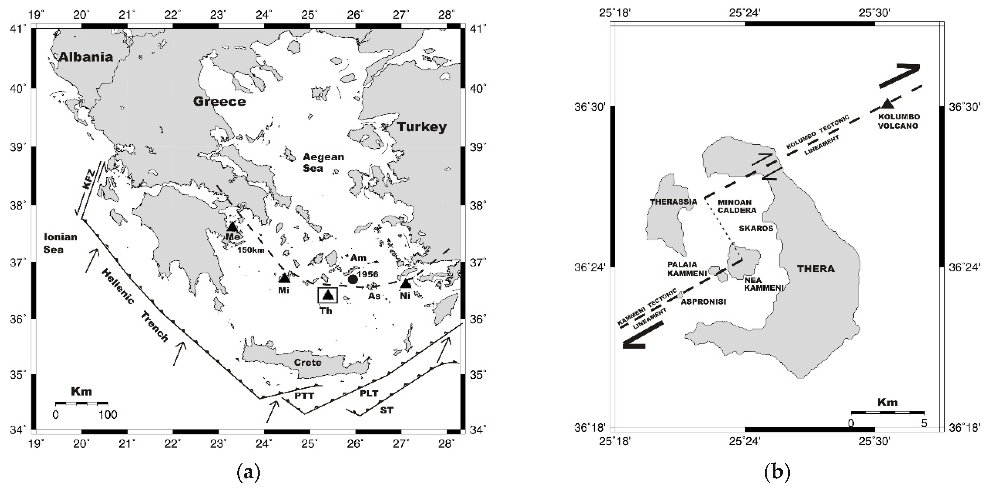
Figure 2.
Landscape of Santorini island complex as prepared in the field by Olivier [12]. In the caldera three smaller islands were illustrated in a quite similar placement as they were independently illustrated by Comte de Choisel-Gouffier [13]: Hiéra (Palaia Kameni), Nea Kameni and Mikri Kameni. Arrow shows the position of Ammoudi bay which is of interest to the analysis of the 1667 CE episode. Scauro is the Skaros promontory, which is also of interest for the examination of some eruptions.
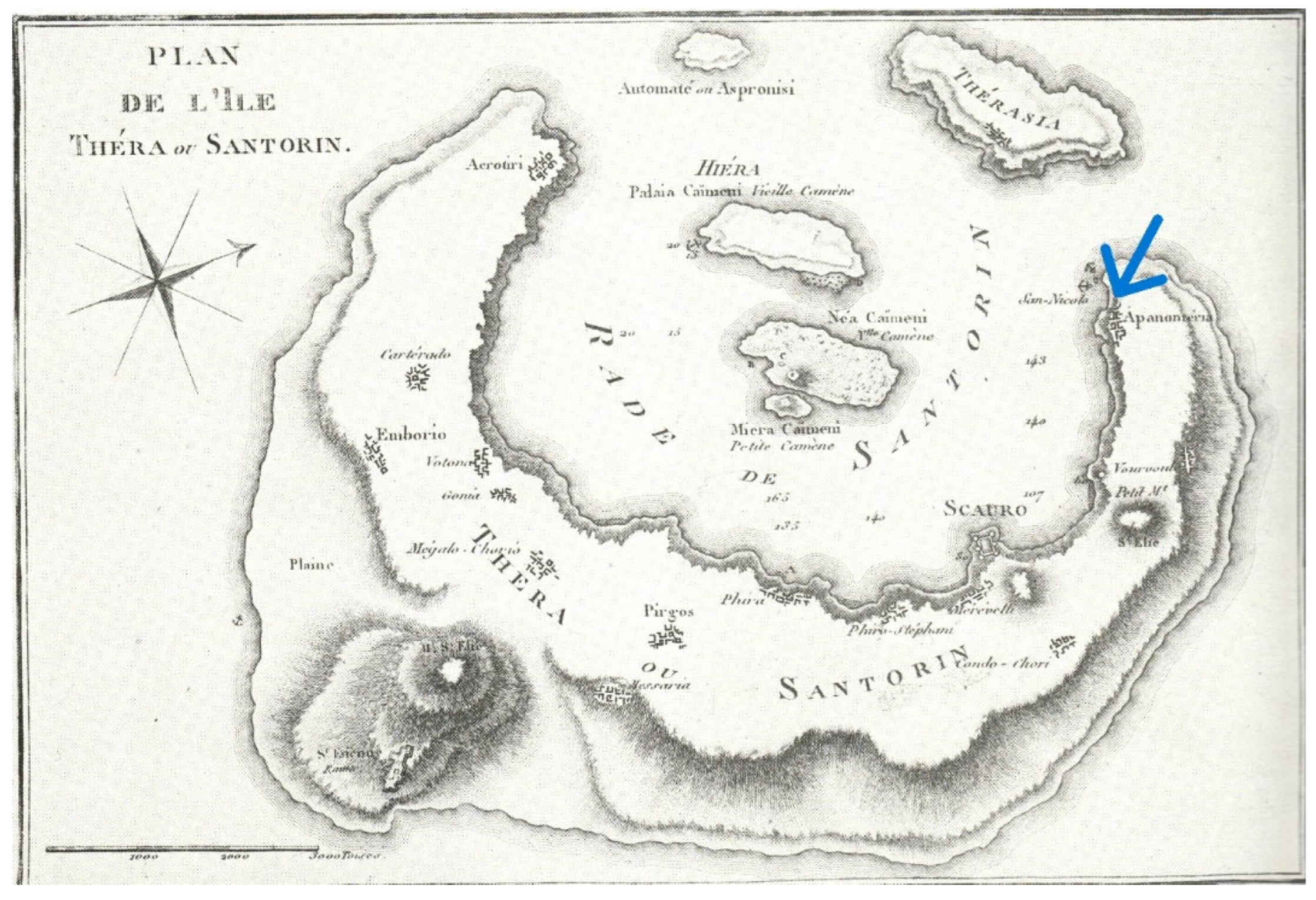
Figure 3.
The fault scarp or detachment (a), visible on the northeastern side of Palaia Kameni (b) (photo courtesy of G.A. Papadopoulos). From the documentary sources available the mechanism that caused this failure is not clear: earthquake, volcanic eruption or gravitative landslide?
Figure 3.
The fault scarp or detachment (a), visible on the northeastern side of Palaia Kameni (b) (photo courtesy of G.A. Papadopoulos). From the documentary sources available the mechanism that caused this failure is not clear: earthquake, volcanic eruption or gravitative landslide?
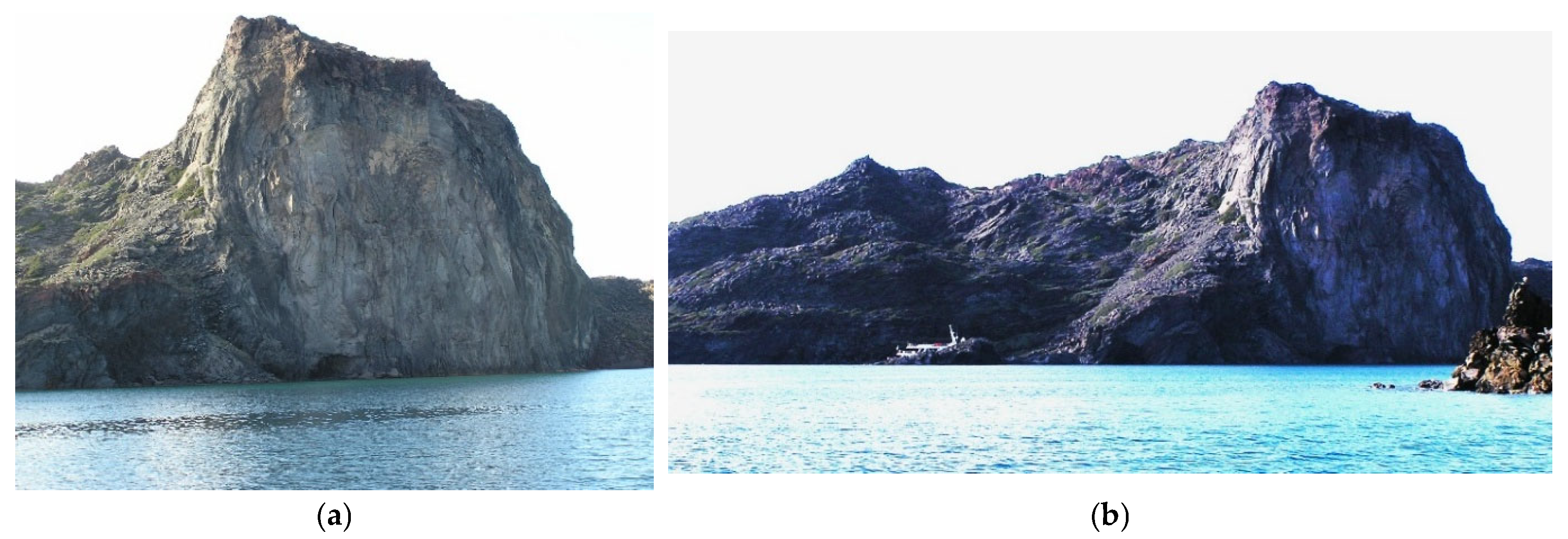
Figure 4.
Landscape of Santorini island complex roughly mapped by Goree (1712) [36] in the aftermath of the 1707-1711 eruption. The caldera is surrounded by Santorini, with the Skaros promontory in the middle, Aspronisi at the NW and Therasia at N. In the caldera the next islands are shown from east to west: Lesser (Mikri) Kameni; the New or Black Island, the largest one; the small White Island in a bay at the south of Black Island; Great (Palaia) Kameni to the west of Black Island.
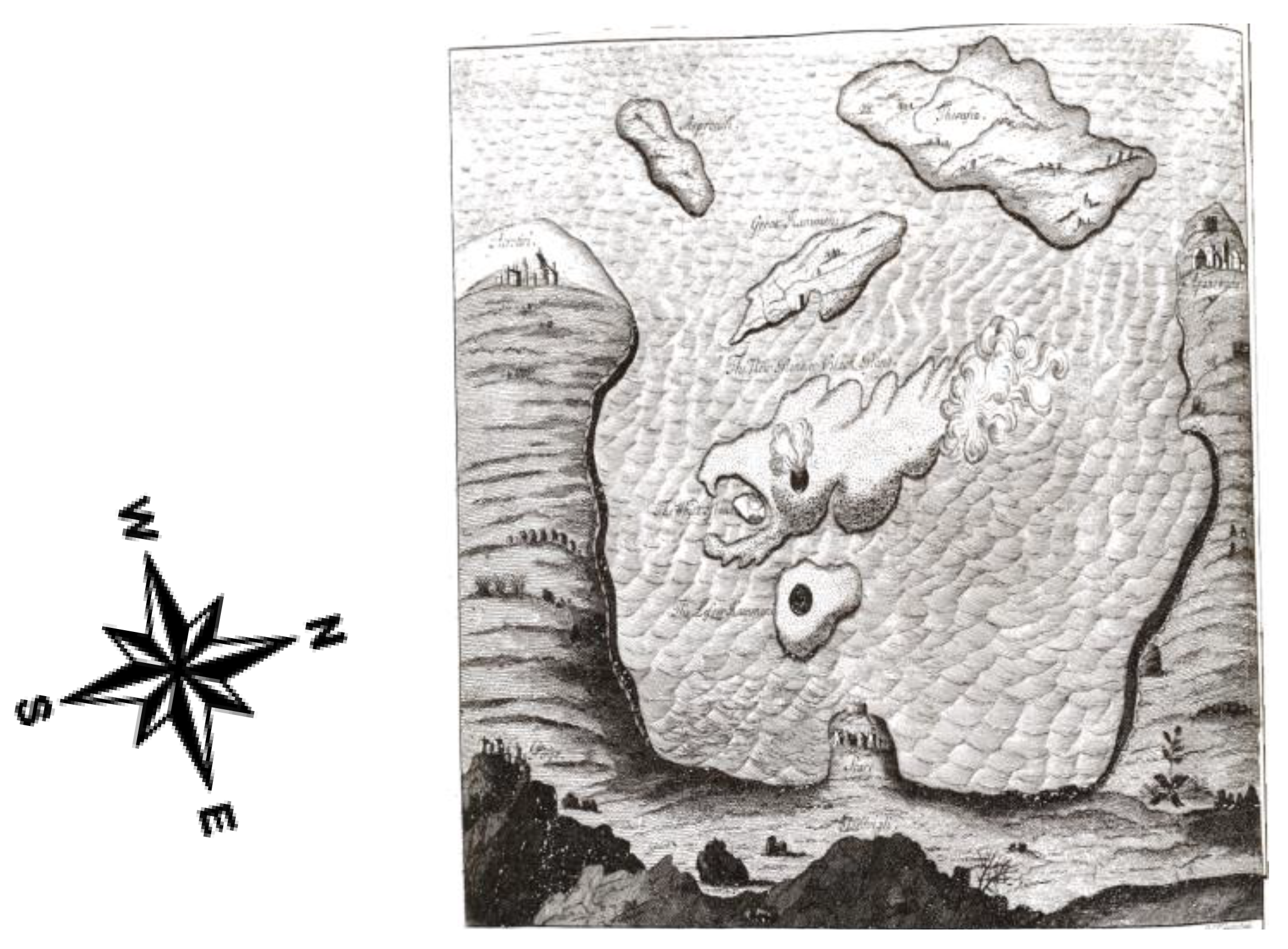

Table 1.
Main features of the 14 historical eruptions identified in the Santorini area.
| Date | Reliability | VEI | Main volcanic landscape changes |
|---|---|---|---|
| 197/196 BCE | 4 | 2-3 | Hiera Island emerged |
| 46 July 6 CE | 4 | 2-3 | Thia (Palaia Kameni) Island emerged |
| 725/726 | 4 | 4-5 | Hiera increased |
| 1457 Nov. 25 | 2 | ? | ? |
| 1572 spring-summer | 4 | 3-4 | Mikri Island emerged |
| 1650 Oct. 9 | 4 | 4-5 | Submarine Kolumbo cone collapsed |
| 1667 Feb. | 2 | ? | ? |
| 1707 July-1711 Sept. 3 | 4 | 3-4 | White and Black Islands emerged; generation of Nea Kameni Island |
| 1773 Jan. 10 | 3 | 2-3 | Mikri Kameni extented northward |
| 1866 Jan.-1870 Oct. 2 | 4 | 2-3 | Nea Kameni increased |
| 1925 Aug.-1926 Jan. | 4 | 2 | Mikri and Nea Kameni united |
| 1928 Jan.-March | 4 | 2 | A new small dome at Nea Kameni |
| 1939 Aug.-1941 July | 4 | 2 | New small domes at Nea Kameni |
| 1950 Jan.-Feb. | 4 | 2 | A new small dome at Nea Kameni |
Disclaimer/Publisher’s Note: The statements, opinions and data contained in all publications are solely those of the individual author(s) and contributor(s) and not of MDPI and/or the editor(s). MDPI and/or the editor(s) disclaim responsibility for any injury to people or property resulting from any ideas, methods, instructions or products referred to in the content. |
© 2026 by the authors. Licensee MDPI, Basel, Switzerland. This article is an open access article distributed under the terms and conditions of the Creative Commons Attribution (CC BY) license (http://creativecommons.org/licenses/by/4.0/).
Copyright: This open access article is published under a Creative Commons CC BY 4.0 license, which permit the free download, distribution, and reuse, provided that the author and preprint are cited in any reuse.


