
Submitted:
08 February 2026
Posted:
09 February 2026
You are already at the latest version
Abstract
Urban mobility is a central challenge for sustainable and inclusive cities, as climate change, congestion, and spatial inequality expose mobility patterns as expressions of deeper social and spatial structures. Inclusive urban mobility examines whether transport systems equitably support the everyday movements and accessibility needs of historically marginalized and underserved populations. The integration of AI with geographic information science, together with multimodal geospatial data fusion, provides powerful tools to diagnose and address these disparities by combining heterogeneous sources such as satellite imagery, GPS traces, transit records, volunteered geographic information, and social sensing into scalable, high-resolution urban mobility analytics. The main aim of this paper is presenting a systematical review of recent GeoAI studies that fuse multiple geospatial modalities for key tasks such as accessibility mapping, demand forecasting, and origin–destination flow prediction, with particular emphasis on inclusive and equity-oriented applications. The survey synthesizes methodological trends across data-, feature-, and decision-level fusion, highlights the growing use of deep learning architectures, and examines emerging techniques including knowledge graphs, federated learning, and explainable AI shape equity-relevant insights in diverse urban contexts. Building on this synthesis, the review identifies persistent gaps in population coverage, multimodal integration, equity optimization, explainability, validation, and governance that constrain the inclusiveness and robustness of current GeoAI practices, and proposes a structured research roadmap linking these gaps to actual methodological and governance directions—such as equity-aware loss functions, adaptive fusion pipelines, participatory and human-in-the-loop workflows, and urban data trusts—to better align multimodal GeoAI with the goals of inclusive, just, and sustainable urban mobility systems.
Keywords:
GeoAI
; multimodal data fusion
; urban mobility
; spatial equity
; explainable AI
; participatory analytics
; federated learning
; urban policy
1. Introduction
Urban mobility fundamentally shapes development, influencing the distribution of economic opportunities, access to essential services, and overall societal participation. [1,2]. However, significant inequities persist, particularly among marginalized groups that face structural barriers to reliable and accessible transportation [3,4]. Research demonstrates significant disparities in transit and micro-mobility access for minority and disadvantaged neighborhoods. For example, a spatial analysis in Austin, Texas found that nearly 80% of residents, especially those in transit-dependent and Black-majority areas, have no access to bikes and scooters, highlighting extreme inequity in micro-mobility services [5]. Similarly, studies in cities like San Antonio reveal that low-income and minority communities often face limited access to public transit and bike-sharing systems, which exacerbate existing divisions along lines of income, race, and class [6,7].
These inequities in transit and micro-mobility access can reinforce social segregation and limit opportunities for disadvantaged groups, including by gender and age, as mobility patterns and technological barriers further restrict access for certain populations [5,6,7,8,9]. These exclusions lead to layered disadvantages, including limited mobility options, increased social and economic gaps, and disproportionate exposure to environmental risks such as air pollution [10]. Social and spatial segregation further restricts vulnerable populations’ access to jobs, healthcare, and education, perpetuating inequity over time.
Recent advances in Geospatial Artificial Intelligence (GeoAI) offer powerful and evidence-based pathways to diagnose and mitigate systemic mobility inequities that traditional approaches have long struggled to address. GeoAI, which emerged at the intersection of machine learning, geographic information science, and urban analytics in the early 2010s, integrates deep learning and AI methods with geospatial data to move beyond descriptive mapping toward predictive and prescriptive modeling of complex urban phenomena [1]. Unlike conventional transportation planning, which relies on periodic surveys and aggregated statistics, GeoAI leverages multimodal datasets—including satellite and street-level imagery, GPS mobility traces, sensor networks, and volunteered geographic information—to analyze urban environments with unprecedented spatial and temporal resolution [11,12,13]. This technological shift enables researchers and planners to detect fine-grained accessibility barriers, quantify service disparities at neighborhood scales, and identify under-served populations that are often invisible in coarser datasets, thereby grounding equity-focused interventions in evidence rather than assumption.
Contemporary GeoAI techniques, such as convolutional neural networks (CNNs) for feature extraction from imagery, graph neural networks (GNNs) for spatial network analysis, transformer architectures for multimodal data fusion, and federated learning frameworks for privacy-preserving collaborative analytics, enable the characterization of urban environments, detection of accessibility barriers, and joint model training across distributed agencies or cities [14,15,16,17,18]. These methods address specific challenges that impede equitable urban mobility analytics:
- data heterogeneity—integrating diverse modalities with mismatched resolutions and formats[15];
- algorithmic bias—detecting and correcting systematic under-representation of marginalized communities in training data[16];
- scalability—processing large-volume geospatial big data across cities and regions[17]; and
- interpretability—using explainable AI techniques to ensure that model decisions can be audited and trusted by stakeholders[18].
Despite these technological advancements, significant challenges persist around data quality, representational bias, computational resource constraints, privacy and governance concerns, and the limited transferability of models across urban contexts [19,20,21]. Recent scholarship increasingly emphasizes the importance of transfer learning, large-scale multimodal fusion, federated learning, explainable AI (XAI), and human-in-the-loop approaches as essential for building GeoAI systems that are both technically robust and ethically sound [19,20,21]. Advances in user-friendly interfaces and natural language interpretability tools have further democratized access to sophisticated geospatial insights, making them accessible to urban planners and policymakers who may lack deep technical expertise [20].
This review contributes by systematically synthesizing state-of-the-art GeoAI approaches for inclusive urban mobility, analyzing current challenges and research gaps, and laying out strategic directions for equity-focused urban mobility analytics. The subsequent sections review the conceptual, methodological, and application-oriented progress in GeoAI and multimodal urban analytics before outlining future directions for research and practice grounded in both evidence and equity principles.
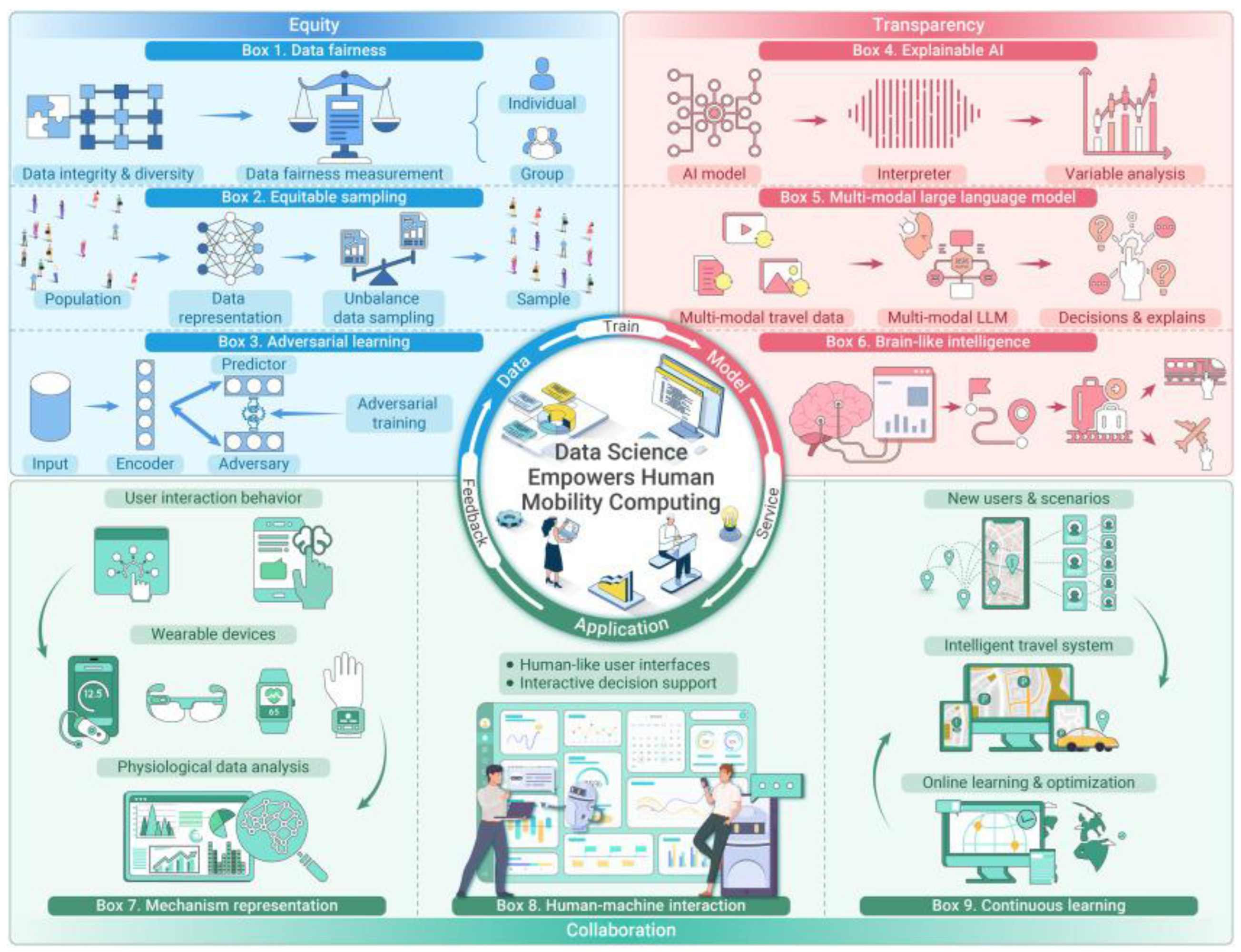
Figure 1.
GeoAI and multimodal data fusion framework for inclusive urban mobility, emphasizing equity, transparency, and application layers [22].
Figure 1.
GeoAI and multimodal data fusion framework for inclusive urban mobility, emphasizing equity, transparency, and application layers [22].
2. Theoretical and Conceptual Foundations
2.1. Urban Mobility Inequities: Population, Spatial, and Social Perspectives
Urban mobility, which is fundamental to sustainable city development, is a key determinant of social inclusion, economic opportunities, and environmental quality. However, access remains deeply uneven, particularly among marginalized populations. Persistent inequities, such as minority neighborhoods experiencing less transit access than majority white areas [10], reflect longstanding structural injustices in urban transportation systems. These gaps extend beyond traditional public transit, with research revealing that up to 80% of residents in certain cities, particularly low-income groups, lack access to emerging micromobility options such as bike sharing and e-scooters [11], further restricting mobility and compounding social and economic exclusion. Intersectional barriers shaped by gender, age, disability, and income exacerbate disadvantages, necessitating equity assessments that account for complex, overlapping vulnerabilities. Environmental injustice intensifies these issues: disadvantaged neighborhoods often experience disproportionately higher exposure to pollutants from traffic. It was shown that ultrafine particle concentrations to be 34% higher in socioeconomically deprived Toronto districts [12,23]. Social and spatial segregation, especially in peripheral metropolitan areas, leaves many low-income and minority communities with limited transit access, reinforcing systemic cycles of exclusion from employment, healthcare, and education, and perpetuating spatial inequality [4].
2.2. Accessibility and Spatial Equity Theories
Mobility barriers arise from interactions among the built environment, service provision, and social policy. Two influential frameworks guide spatial equity analysis.
1. Right to the City: This concept, advanced by Lefebvre and Harvey, asserts the collective right of urban residents to shape and access city spaces, placing emphasis on equitable transport as a foundation for inclusion [24,25].
2. Capability Approach: Sen’s framework interprets equity as the substantive freedoms individuals require to pursue valued outcomes, shifting the focus from mere physical mobility to flexibility and opportunity to achieve life goals [26].
Inclusion is evaluated across several key dimensions [27]:
- Availability: Presence and diversity of mobility options;
- Accessibility: Ease of reaching desired destinations;
- Acceptability: Cultural and social appropriateness;
- Flexibility: Adaptability to various user needs
These criteria provide a multidimensional basis to evaluate how transportation systems cultivate or constrain urban inclusion.
2.3. Built Environment and Inclusivity
The characteristics of the built environment, walkability, bikeability, and degree of transit integration critically affect mobility equity. Well-connected, safe, and accessible networks foster active travel and expand opportunities [28,29], whereas fragmented or underinvested infrastructure disproportionately hinders persons with disabilities, seniors, and low-income residents in marginalized neighborhoods [30]. Therefore, inclusive urban design and equitable planning are fundamental to reducing mobility gaps and improving the urban quality of life.
3. Overview of GeoAI and Multimodal Data Fusion Methods
3.1. Evolution of GIScience in the Era of GeoAI
Traditional GIScience has centered on spatial data management, mapping, and foundational spatial analytics in urban studies. The recent paradigm shift toward GeoAI integrates machine learning (ML), deep learning (DL), and advanced spatial statistics with geospatial data, advancing from descriptive mapping to predictive modeling of complex, dynamic urban phenomena [15]. GeoAI leverages large-scale heterogeneous datasets, including satellite imagery, sensor feeds, and participatory maps, permitting automated interpretation of intricate mobility patterns, accessibility barriers, and equity outcomes [14].
3.2. Machine Learning, Deep Learning, and Explainable AI (XAI)
GeoAI employs a diverse suite of models and computational paradigms, ranging from classical machine learning and spatial statistics, such as Random Forests (RF), Support Vector Machines (SVM), and Geographically Weighted Regression (GWR), which are foundational for analyzing land use, transit accessibility, and socioeconomic mobility outcomes [16,18], to convolutional and recurrent neural networks (CNNs/RNNs) that automate barrier detection from imagery and model service unreliability, often surfacing inequities in transit operations [17,31]. GNNs represent urban street and transit networks as interconnected systems, enabling the prediction of connectivity gaps and accessibility vulnerabilities in urban street networks [32,33]. Transformer-based architectures fuse multimodal urban data and extract contextual dependencies for equity analyses. Complementing these, XAI techniques (e.g., SHAP, LIME) promote transparency and interpretability for fairness auditing and policy trust, and federated learning (FL) supports privacy-preserving, collaborative analytics across jurisdictions, which is key for multi-city and multi-agency equity research [14,34,35].
3.3. Data Fusion Techniques
GeoAI-driven urban analytics benefit from multimodal data fusion strategies [36] that integrate heterogeneous sources—sensors, satellite imagery, OSM, and mobility traces—to capture complex urban dynamics. These span three canonical levels identified across reviewed studies:
- -
- Data-level fusion- Integrates raw heterogeneous data before feature engineering via spatial/temporal alignment, imputation, or generative augmentation;
- -
- Feature-level fusion- combines extracted features/embeddings to unify information from disparate sources;
- -
- Decision-level fusion- aggregates outputs from individual models, supporting ensemble predictions and robust scenario analyses.
3.4. Participatory Approaches and Human-in-the-Loop Design
Open-source geospatial platforms such as QGIS or GeoPandas, and Google Earth Engine have lowered technical and financial barriers to conducting spatial analyses, particularly for researchers, local governments, and civil society groups with limited proprietary software access. Citizen-generated maps and social sensing, including OpenStreetMap edits, participatory GIS, and geotagged social media, embed lived experiences in mobility models and make it easier for non-specialist contributors to shape how urban environments are represented. Human-in-the-loop GeoAI workflows and co-designed workshops promote procedural justice by embedding stakeholder engagement directly into analysis and decision-making processes [37,38].
3.5. GeoAI Data Fusion Pipeline
The overall GeoAI multimodal data fusion workflow is summarized in Figure 2. GeoAI multimodal data fusion pipeline for urban mobility equity. Diverse geospatial inputs (satellite imagery, GPS traces, participatory GIS, census and municipal GIS data, street-level photos, and social media) are integrated through data- level, feature- level, and decision-level fusion, processed with classical spatial machine learning, deep learning for imagery, spatiotemporal models, graph-based GeoAI, and explainable AI, to produce accessibility maps, equity indicators, and demand forecasts for inclusive urban mobility planning.
4. Multimodal Geospatial Data in Urban Mobility
Integrating data from diverse established and emerging sources is essential for robust, inclusive urban mobility research. Traditional sources, such as static survey data, census records, and transit timetables, offer baselines for demographic and equity analysis but often lack the temporal and spatial precision needed to reveal mobility disparities [39].

Table 1.
Summary of Geospatial Data Types for Urban Mobility Equity Assessment.
| Data Type | Source | Challenge | Equity Impacts |
|---|---|---|---|
| Satellite Imagery | NASA, Copernicus | Cloud cover, resolution | Misses informal/ground detail [15] |
| GPS Traces | Phones, Taxis | Signal gaps, user bias | Skewed to affluent travelers [10] |
| OpenStreetMap | Crowdsourcing | Under-mapping | Underrepresents poor areas [37,38] |
| Social media | Twitter, Facebook | Sentiment, sample, privacy | Reflects perceptions, not all users [47] |
| Participatory GIS | Citizen mapping | Engagement, data quality | Captures lived experience [46] |
| Census Data | National statistical offices | Coarse spatial/temporal resolution; undercounts | Masks intra-neighborhood disparities; may miss marginalized groups [39,48] |
| Municipal GIS Data | City planning/transport departments | Inconsistent coverage; update frequency | May omit informal areas; reflect institutional priorities [39,49] |
| Shade Maps | Remote sensing, urban climate models | Seasonal variability; model uncertainty | Misses micro-scale thermal stress along everyday paths: heat exposure is often highest for vulnerable groups [50,51] |
| Street-level Photos | Google Street View, Baidu, Mapillary | Coverage bias; occlusion; privacy | Overrepresents well-served areas; inequities in visual walkability and streetscape quality across neighborhoods [52,53] |
In contrast, new geospatial data types, such as GPS trajectories, IoT sensor feeds, OpenStreetMap (OSM), high-resolution satellite imagery, and participatory mapping, provide rich, real-time information on movement, infrastructure, and experience [12,37]. Crowdsourced and participatory data, including citizen-generated maps and social media, further enrich analyses of lived experiences, perceptions, and unique mobility perspectives [46,47]. Additional sources such as census microdata, municipal GIS layers, shade maps, and street level imagery further enrich equity assessment by linking mobility with social structure, climate exposure, and perceived walkability.
This integrated approach demonstrates that a holistic, equity-oriented urban mobility analysis not only depends on technological advancements in data fusion, but also on critical evaluation of representational biases and accessibility within each data source.
5. Methods: Systematic Survey
5.1. Review Design and Scope
This study adopts a structured, state-of-the-art survey with systematic elements to synthesize recent advances in GeoAI and multimodal geospatial data fusion for urban mobility. Rather than conducting a full PRISMA-style systematic review, the approach combines transparent search procedures, explicit inclusion criteria, and comparative synthesis, which is well suited to a rapidly evolving, interdisciplinary field where terminology, data modalities, and evaluation practices vary across geography, transportation science, and artificial intelligence.
The scope focuses on empirical urban mobility studies that integrate two or more geospatial data modalities using machine learning or deep learning methods, with particular attention to accessibility, demand forecasting, origin–destination (OD) flows, and equity-relevant mobility outcomes.
5.1.1. Literature Search Strategy
A semantic literature search was conducted using the Elicit platform, which aggregates and indexes publications from Semantic Scholar and OpenAlex, covering more than 138 million academic records. Semantic search was selected to capture conceptually relevant studies across disciplines where similar methods may be described using different terminology.
The search targeted peer-reviewed journal articles and high-quality conference papers published approximately between 2019 and 2025, reflecting the period during which GeoAI and multimodal data fusion methods have matured in urban analytics.
Search queries combined thematic concepts related to:
- GeoAI and geospatial artificial intelligence;
- Multimodal or multi-source data fusion;
- Urban mobility, transportation, accessibility and equity;
- Traffic prediction, demand forecasting, and origin–destination modeling;
- Participation and ethics.
The initial search returned to 57 candidate studies deemed highly relevant based on semantic similarity and citation context.
5.1.2. Study Screening and Selection
Study selection was performed using a two-stage screening process. First, titles and abstracts were reviewed to exclude papers that: (i) addressed non-urban or non-mobility domains; (ii) relied on a single data modality; or (iii) focused on purely conceptual or methodological topics without empirical application.
Second, full-text screening was conducted to retain only the studies that:
- Two or more geospatial data modalities (e.g., GPS traces, mobile phone data, satellite imagery, transit records, crowdsourced maps) were employed;
- Data-, feature-, or decision-level fusion techniques were applied;
- Urban mobility tasks such as accessibility mapping, traffic or demand forecasting, travel behavior modeling, and OD analysis were addressed;
- Reported quantitative evaluation metrics or comparative performance against the baselines.
5.1.3. Data Extraction and Analytical Framework
A structured data extraction protocol was applied to each included study, capturing a common set of attributes. For every paper, the extracted information covered the urban mobility task and application domain, the geographic context and spatial scale, and the geospatial data modalities that were combined. Details on the fusion strategy (data--, feature--, or decision--level) and core modeling approaches—for example, CNNs, RNNs/LSTMs, GNNs, transformers, or knowledge--graph models—were also recorded, together with the evaluation metrics reported (such as RMSE, MAE, MAPE, accuracy, or F1--score) and any explicit considerations related to equity, explainability, or fairness. To support comparative synthesis, studies were then grouped according to fusion strategy and application domain, enabling cross--study comparison of methodological effectiveness, scalability, and interpretability.
5.1.4. Synthesis and Evaluation Approach
Given the heterogeneity of data sources, prediction targets, and evaluation metrics across studies, a qualitative comparative synthesis was adopted rather than a meta--analysis. Model effectiveness was assessed relative to reported single--source or non--fusion baselines, with attention to trade--offs between predictive performance, computational complexity, and interpretability.
In practice, the comparative synthesis proceeded along two main dimensions: fusion strategy and application task. For each study, multimodal fusion models were contrasted with their corresponding single--source or non--fusion baselines, focusing on relative gains in accuracy, stability across time and space, and changes in interpretability. Where available, subgroup results (for example, performance across different neighborhoods or time periods) were also examined. This approach enabled a qualitative comparison of how data, feature, and decision--level fusion perform for different mobility problems, rather than relying solely on raw error metrics.
Formal numerical quality scoring was not applied because of the diversity of experimental designs and validation protocols. Instead, methodological robustness was assessed qualitatively based on transparency of model design, use of baselines, validation strategies, clarity of reported results, and whether explainable AI techniques or equity--oriented evaluation criteria were incorporated.
5.2. Summary of Included Studies
The convergence of geospatial artificial intelligence (GeoAI), multimodal data fusion, and urban mobility research represents a rapidly evolving frontier in intelligent transportation systems and smart city development. This review synthesizes recent advances across these interconnected domains to provide context for the state--of--the--art survey on GeoAI and multimodal geospatial data fusion for inclusive urban mobility. Table 2 summarizes eighteen multimodal GeoAI studies by core methodology, prediction task, geographic scope, data modalities, and study identifier, spanning applications such as walkability assessment, traffic and OD--flow forecasting, mode choice classification, demand prediction, and next--place recommendation.
Existing work can be grouped into two broad strands: multimodal and spatiotemporal demand forecasting, and data--fusion--based travel mode analysis. On the demand side, several frameworks combine heterogeneous mobility and contextual data to predict short--term demand or flows, typically showing that multimodal integration reduces error relative to single--source baselines. GT--LSTM integrates LSTM with attention over multimodal transport and geographic features, reducing MAPE and RMSE compared with ConvLSTM and GCN baselines on a multimodal urban dataset. FusionTransNet and the Spatio--Temporal Mobility Demand Forecaster (ST--MDF) fuse taxi, bike, bus, and weather or temporal features using graph neural networks or spatiotemporal machine learning, demonstrating that learning from multiple modes jointly improves OD--flow and demand forecasts in large and medium–large cities. MDTP applies simple multi--source fusion operators (sum and concatenation) over taxi and bike--sharing data in New York and Chicago, showing that relatively lightweight fusion schemes can still enhance cross--mode demand prediction. At a finer operational level, GSABT employs graph sparse attention with a bidirectional temporal convolutional network to jointly predict multimodal traffic, while STGATN targets bike--sharing e--fence demand using a hybrid of GCN, Bi--LSTM, weather attention, and Transformer modules; both report state--of--the--art accuracy on real multimodal datasets. Complementary low--dimensional and rule--based bike--sharing models indicate that hierarchical clustering with regression or interpretable rule sets can yield competitive-level forecasts when combining trip and weather data, which is attractive for practitioners prioritizing transparency and low computational cost over maximal accuracy.
On the behavioral side, mode choice and mode detection studies emphasize fusing survey, passive sensing, and environmental data. Matrix Trifactorization in Santiago integrates mobile phone traces, travel surveys, census information, smart--card records, and OSM data to estimate municipal--level mode split, illustrating how combining rich but noisy passively collected traces with traditional surveys can reduce bias and improve spatial coverage. At the individual level, stacking models with denoising autoencoders and Random Forests, as well as other stacking ensembles, exploit travel diaries, socio--demographics, and built--environment indicators to classify travel mode with high accuracy while surfacing influential factors such as car ownership, urban density, and transit accessibility.
Smartphone--based mode identification in Hangzhou uses SVM and gradient boosting on GPS trajectories labeled via surveys and enriched with A--Map API information, showing that combining phone sensors with detailed network attributes substantially improves mode classification performance. More recent interpretable machine--learning frameworks that integrate traditional travel surveys with Amap API path, time, and cost attributes demonstrate that multimodal, multi--source fusion can be both accurate and capable of explaining mode choice behavior in ways that are usable for policy analysis.
Taken together, the studies in the updated table highlight a consistent pattern: heterogeneous data fusion across modes, sensors, and contextual layers, coupled with spatiotemporal deep architectures such as LSTMs with attention, GNNs, CNN–RNN hybrids, and Transformer--style components, systematically outperforms single--source or single--modal baselines for both demand prediction and mode choice [63,64,67,68,70,72,73,74,76,77,78,79]. In parallel, a line of work on lower--dimensional or interpretable models explores how to balance accuracy, transparency, and deployment complexity by combining simpler regression or rule--based structures with carefully designed multimodal features. Collectively, these studies show that multimodal urban mobility models are evaluated predominantly with RMSE, MAE, MAPE, accuracy, and F1 and that dense mobile traces and POI information tend to provide the strongest individual predictive signals [61,62,63,64,65,66,67,68,69,70,72,73,74,75,76,77,78,79].
At the same time, they reveal systematic gaps: a strong bias toward large, instrumented cities, limited transferability to medium--sized or under--resourced contexts, equity and fairness objectives rarely embedded in model design, validation focused on aggregate accuracy within single metropolitan areas, and minimal integration of participatory or human--in--the--loop workflows [61,62,63,64,65,66,67,68,69,70,72,73,74,75,76,77,78,79]. As a result, GeoAI and multimodal fusion form a powerful but not yet equity--configured toolkit; realizing their potential for inclusive urban mobility will require equity--aware loss functions and evaluation criteria, participatory validation with affected communities, and governance and interoperability frameworks that regulate how multimodal mobility data are collected, shared, and used in decision--making across diverse urban environments.
6. Application Domains
6.1. Walking, Micromobility, and Accessibility
6.1.1. Accessibility Mapping and Equity Assessment
GeoAI-driven data fusion has significantly advanced accessibility analytics by integrating street-level imagery, transit network topology, IoT sensor streams, participatory mapping, and census microdata to assess how transport infrastructure is spatially distributed and uncover fine-grained access disparities [10,37,54,55,56]. Which used CNNs to extract pedestrian barrier features (curb ramps, crosswalks, tactile paving) from street-level imagery, then fused this with transit schedules and population demographic data to map accessibility neighborhoods where seniors and people with disabilities face compounded barriers. The model identified that 34% of bus stops in low-income census tracts lacked accessible sidewalk connections, compared to just 8% in affluent areas, quantifying an equity gap that traditional audits often miss [35,54].
However, critical limitations persist. Street-level imagery itself exhibits significant geographic bias: Google Street View provides comprehensive coverage in wealthy North American and European cities but sparse or outdated coverage in the Global South, informal settlements, and rural areas [52,53]. Studies employing this data source therefore risk invisibilizing the very populations most affected by accessibility barriers [46]. Furthermore, models trained in high-income cities often fail when transferred to low-income urban contexts, where informal transportation modes (paratransit, informal settlements without formal address systems) and non-standard infrastructure dominate [15]. Only a handful of reviewed studies ([35,54]) explicitly address this transferability challenge through domain adaptation or fairness constraints; most assume that a model trained in New York or London can be deployed in Santiago or Lagos without context-specific validation—an assumption that equity-oriented research should systematically reject.
Additionally, accessibility mapping alone does not guarantee equity outcomes. A study mapping gaps may identify where to invest, but without participatory co-design with affected communities, technical recommendations may overlook local knowledge about safety, cultural appropriateness, and actual usage patterns [46,47].
6.1.2. Demand Forecasting and Scenario Analysis
Integrating heterogeneous data modalities, including mobile phone records, transit smart card uses, and social media sentiment, GeoAI enables the accurate forecasting of mobility demand and user flows [57]. Deep learning models such as RNNs and transformers predict ridership patterns and evaluate the impact of events or urban changes on travel demand [4,56]. Furthermore, Scenario analysis tools, enhanced by multimodal data fusion, support mobility system resilience testing and policy-driven simulations for future urban growth or disruption scenarios [58]. This limitation suggests that scenario-analysis tools should be coupled with real-time participatory feedback mechanisms and continuous model retraining, practices still uncommon in deployed systems.
6.1.3. Infrastructure Planning and Policy Decision Support
GeoAI applications have improved transport infrastructure planning by fusing satellite imagery, crowdsourced maps, and IoT sensor data to assess current conditions, forecast maintenance needs, and optimize network expansion [15,39]. Federated learning frameworks enable multi-agency collaboration without compromising privacy and supporting regional and cross-jurisdictional transport analyses [58]. Equitable investment prioritization and policy evaluation tools now leverage spatial and temporal fusion models to ensure that benefits reach communities that are most in need [4]. Critically, deploying optimized plans without meaningful community engagement risks reproducing existing power imbalances. Optimization algorithms make assumptions about what constitutes “demand” or “benefit” based on historical data, which reflect past investment patterns and may encode historical exclusions. Recent work emphasizing participatory and human-in-the-loop approaches ([37,38], demonstrates that integrating community priorities and lived experience can substantially revise infrastructure priorities, yet this integrative approach remains rare in practice.
6.1.4. Specialized Domains: Maritime Mobility, Micromobility
Beyond traditional urban transit, GeoAI techniques have been applied to specialized domains, such as maritime mobility and emerging micromobility services. In maritime studies, multimodal data fusion of Automatic Identification System vessel trajectories, satellite imagery, and geospatial databases uncover routing patterns, detect illegal activity (“dark vessel” detection), and improve port accessibility analysis [59,60]. For micromobility (e-scoters and bike-share), fusion models combine GPS traces, crowdsourced infrastructure data, and real-time user feedback to study safety, accessibility, and usage equity [5,18]. This application highlights an important potential: GeoAI can surface invisible economic actors and exclusions, though the focus typically remains on surveillance and enforcement rather than empowerment.
6.2. Implications for Urban Planning and Policy
Emerging GeoAI research points to several implications for how planners and policymakers might use these tools in practice, while also highlighting important cautions. Recent work suggests that multimodal GeoAI can support the identification of “service deserts” by revealing neighborhoods with systematic gaps in transit, walking, or micromobility access, which in turn can guide more targeted investments in routes, stations, or pedestrian infrastructure [80]. Studies also show that GeoAI can be used to evaluate alternative policy and planning scenarios, enabling public authorities to rely on quantitative simulations to optimize implementation and reduce social and financial costs in smart and healthy city initiatives [81].
Scenario--based GeoAI applications allow planners to simulate how transit expansion, land--use change, or new micromobility regulations could alter accessibility for different demographic groups, offering a more explicit lens on distributional impacts than traditional aggregate indicators. Real--time or high--frequency fusion of GPS, sensor, and crowdsourced data creates opportunities for continuous monitoring of system performance and faster detection of service disruptions that disproportionately affect vulnerable populations. At the same time, several studies caution that such approaches risk privileging corridors and user groups that generate dense digital traces, so proactive safeguards are needed to ensure that data--driven monitoring frameworks do not further marginalize areas with weak data coverage [81,82].
Incorporating participatory GIS, human--in--the--loop workflows, and community review of model outputs can help ground technical insights in local knowledge, improve the legitimacy of decisions, and surface mismatches between modeled accessibility and lived experience, although such practices demand time, facilitation capacity, and sustained institutional commitment. From a decision--support perspective, fairness--constrained models and equity--oriented evaluation criteria can be used to prioritize infrastructure upgrades and service expansions toward communities with the largest mobility gaps, rather than simply maximizing aggregate efficiency. However, these tools do not replace political judgment: equity constraints are themselves normative choices that must be debated and revisited as conditions change.
Finally, experiences from large, data--rich cities offer valuable methodological lessons for medium--sized or resource--constrained urban areas, but transferability remains limited when institutional capacities, data infrastructures, and mobility cultures differ substantially, underscoring the need for careful local adaptation rather than one--to--one policy transfer.
7. Technical, Ethical, and Practical Challenges
GeoAI for urban mobility operates at the intersection of complex technical systems, sensitive social contexts, and constrained institutional capacities, which creates a set of recurring challenges that shape how multimodal models are designed, deployed, and interpreted. These challenges are not merely implementation details; they influence whose mobility is visible in the data, which forms of exclusion are prioritized, and how reliably equity claims can be supported.
7.1. Data Heterogeneity and Resolution Mismatch
Integrating multimodal geospatial data remains technically challenging owing to differences in spatial resolution, data formats, and coverage. Satellite imagery, GPS traces, crowdsourced OSM layers, and sensor streams often provide information at incompatible scales, resulting in analytical and fusion gaps [15,58]. For example, high--resolution satellite imagery may clearly capture narrow informal footpaths or curb ramps, while coarser census or traffic analysis zones aggregate these features into single units, making it difficult to align fine--grained pedestrian barriers with zone--level accessibility indicators. Resolution mismatches particularly affect the mapping of informal settlements and nuanced pedestrian barriers, which are frequently overlooked in coarse datasets.
7.2. Bias, Representation, and Validation Issues
Equity-oriented urban mobility analytics are persistently affected by biases in data sources and models. OSM and social media datasets commonly underrepresent low-income areas, older adults, and non-digitally connected users [37]. Model training can inherit and amplify these biases if not carefully evaluated [35]. The validation of equity outcomes thus demands careful attention to representative sampling, transparency, and fairness assessments [54,57].
7.3. Ethical, Fairness, and Governance Principles in GeoAI
GeoAI applications increasingly intersect ethical and governance concerns, spanning user privacy, consent for data use, and algorithmic accountability. Federated learning approaches offer privacy-preserving alternatives for distributed model training; however, governance frameworks for data sharing, anonymization, and inclusion are still evolving, especially when fusing personally identifiable mobility traces that require robust protection and ethical review. In parallel, knowledge--guided GeoAI integrates domain expertise, causal reasoning, and contextual constraints into model design, which can improve both predictive performance and the ethical validity of inferences. Fairness--aware GeoAI moves beyond post--hoc bias correction toward embedding equity objectives directly into model training and optimization, for example by enforcing minimum service thresholds for marginalized communities. Finally, reproducibility and openness—through transparent documentation, appropriate open data sharing, and participatory co--design with affected populations—strengthen trust, replicability, and the long--term impact of urban mobility analytics [14,35,38,39].
7.4. Computational Resource Constraints
Machine learning models, particularly deep networks and ensemble fusion frameworks, are computationally intensive and often require significant resources for training, storage, and real-time predictions [14,18]. This creates barriers to equitable deployment in resource-limited municipalities and organizations.
8. Validation Approaches and Assessment Gaps
Validation remains one of the weakest links in GeoAI for urban mobility applications. Many studies report predictive accuracy or cross--validation metrics, but few systematically evaluate equity, robustness, or generalizability, and transferability between cities or demographic contexts is rarely tested beyond a single held--out area or time slice [18,54,56]. In several cases, models that perform well on average error metrics nonetheless misrepresent demand in low--income or transit--dependent neighborhoods, indicating that conventional validation can mask distributional harms.
Explainable AI (XAI) techniques such as SHAP and LIME are increasingly used to audit decision processes and uncover model bias, yet their usefulness in real--world planning is constrained by context--dependent interpretation, sensitivity to model specification, and the difficulty practitioners face in translating local feature attributions into actionable interventions [4,35]. Incorporating expert and stakeholder input—through workshops, participatory mapping, or community review of model output offers a practical route for validating equity implications and identifying unforeseen barriers, for example when residents flag unsafe walking routes or unserved areas that are invisible in routinely collected data. However, such participatory workflows are not yet standard practice and often face scalability, resource, and sustained engagement challenges [71].
Overall, current validation practices rely heavily on technical performance metrics rather than holistic equity or social--impact assessments. Achieving meaningful accountability and distributive justice in urban mobility analytics will require integrating participatory approaches, transparent reporting of model limitations, and explicit equity benchmarks—such as subgroup performance targets or minimum service thresholds—into both evaluation protocols and decision--making processes [37,39].
9. Research Gaps and Future Directions
9.1. Research Gaps
Despite notable advances, several persistent gaps have limited the full realization of GeoAI’s promise for urban mobility equity. First, a population gap exists in research disproportionately focuses on large global cities, leaving medium-sized and marginalized populations underrepresented and limiting the generalizability of models. Second, a methodological gap persists, current models overwhelmingly optimize predictive accuracy or employ post-hoc fairness audits but rarely embed equity and interpretability as integral design objectives.
Multimodal integration remains both technically and ethically challenging. Researchers struggle to align heterogeneous modalities (imagery, GPS, census, social media) and to address spatial bias, data quality, and interoperability, especially in underserved contexts. Most GeoAI solutions measure equity post-hoc, with few actively optimizing for fairness during model training. Explainability and auditability gaps are also evident—popular tools like SHAP and LIME can be unstable and are rarely validated for real-world policy impact.
Reproducibility and participatory design lag: workflow and data sharing are limited, and stakeholder or lived experience integration is rare [39]. Governance and institutional gaps arise from fragmented data custodianship and insufficient cross-sector collaboration, while an implementation gap reflects a lack of robust evaluation of GeoAI solutions for equity or policy goals in truly diverse, real-world urban settings. Finally, there is a stakeholder engagement gap—participatory co-design and evaluation are rarely standard practices in GeoAI system development.
9.2. Recommendations and Roadmap for Advancing the Field
To bridge the identified gaps, future work should develop unified, interdisciplinary frameworks that integrate technical, policy, and social perspectives, enabling GeoAI systems to be designed and evaluated in ways that are both scalable and context sensitive. Within such frameworks, equity-aware modeling and validation need to move beyond post-hoc fairness checks toward embedding fairness constraints, systematic auditing, and robust equity evaluation directly into model training and deployment workflows. At the data level, scalable and quality-focused fusion pipelines are required to confront spatial bias, interoperability challenges, and persistent validation limitations when integrating heterogeneous geospatial modalities.
Advancing GeoAI for urban mobility also depends on opening analytic pipelines to broader stakeholder participation and scrutiny. Open and participatory workflows—grounded in co-design workshops, transparent evaluation protocols, and mechanisms for stakeholder feedback—can support meaningful empowerment and help ensure that model outputs align with local priorities and lived experiences. In parallel, governance innovations such as urban data trusts and cross-sector regulatory frameworks are needed to provide ethical and sustainable structures for data sharing, privacy protection, and accountability in large-scale deployments.
Finally, targeted technological innovation should focus on methods that improve adaptability, robustness, and policy relevance. Promising directions include the use of digital twins, foundation models, and self-supervised learning to better capture complex urban dynamics and transfer knowledge across data-rich and data-scarce settings. Closer integration between modeling efforts and concrete policy and socioeconomic objectives is essential so that GeoAI systems are iteratively evaluated and refined against real-world planning goals and diverse urban applications. A gap-mapping table (Table 3) aligns these research gaps with specific objectives and recommendations to guide future GeoAI-driven urban mobility research and practice.
10. Conclusions
This survey demonstrates that GeoAI, through multimodal geospatial data integration and advanced machine learning, has transformed the analysis of urban mobility equity by enabling nuanced, actionable insights at the intersection of accessibility, infrastructure patterns, and social disparities. While advances in data fusion, explainable models, and participatory analytics have provided new tools for diagnosing and addressing mobility gaps, persistent challenges, such as population bias, methodological limitations, data heterogeneity, and fragmentation in governance, continue to hinder the achievement of just and inclusive mobility systems. Critical issues remain, as models are still frequently optimized for accuracy rather than equity, datasets replicate spatial and demographic biases, and validation seldom extends beyond technical accuracy to encompass fairness, robustness, or social impacts. To advance the field, research and policy must prioritize designing and evaluating models within underrepresented and marginalized urban contexts; embed equity and explainability as core objectives rather than afterthoughts; develop stronger methods for integrating and harmonizing multimodal and heterogeneous data; and create participatory pipelines involving stakeholders and community engagement throughout the research lifecycle. Additionally, robust open-source governance, transparent data-sharing frameworks, and coordinated cross-sectoral collaboration are essential for sustainable equitable GeoAI deployment. Looking forward, the future of GeoAI for urban mobility will hinge not only on technical sophistication but also on its capacity to facilitate procedural and distributive justice. As data sources expand and machine learning matures, frameworks that are collaborative, equity-aware, and transparent will be decisive in realizing urban environments that are not only smarter but also fundamentally fairer, more inclusive, and sustainable. By synthesizing these theoretical, methodological, and ethical imperatives, this review provides both a critical assessment of the current limitations and a practical roadmap for harnessing multimodal GeoAI as a transformative force for urban mobility equity.
Author Contributions
Author Contributions: Conceptualization, methodology, investigation, formal analysis, and data curation, A.K.; writing—original draft preparation, A.K. and A.C.; writing—review and editing, Y.K., I.K., and A.C.; supervision, Y.K., I.K., and A.C. All authors have read and agreed to the published version of the manuscript.
Funding
This research received no external funding.
Conflicts of Interest
The authors declare no conflicts of interest.
Ethics Statement
Not applicable. This study is a review of published literature and does not involve human participants or animal subjects.
References
- Sheller, M. Mobility Justice: The Politics of Movement in an Age of Extremes; Verso: London, UK, 2018. [Google Scholar]
- Turon, K. Sustainable Urban Mobility Transitions—From Policy Uncertainty to the CalmMobility Paradigm. Smart Cities 2025, 8, 164. [Google Scholar] [CrossRef]
- Lotero, L.; Cardillo, A.; Hurtado, R.G.; Gomez-Gardenes, J. Several Multiplexes in the Same City: The Role of Socioeconomic Differences in Urban Mobility. In Interconnected Networks. Understanding Complex Systems; Garas, A., Ed.; Springer: Cham, Switzerland, 2019. [Google Scholar] [CrossRef]
- Kristensen, N.G.; Lindberg, M.R.; Freudendal-Pedersen, M. Urban Mobility Injustice and Imagined Sociospatial Differences in Cities. Cities 2023, 137, 104320. [Google Scholar] [CrossRef]
- Aman, J.J.C.; Zakhem, M.; Smith-Colin, J. Towards Equity in Micromobility: Spatial Analysis of Access to Bikes and Scooters Amongst Disadvantaged Populations. Sustainability 2021, 13(21), 11856. [Google Scholar] [CrossRef]
- Delgado, D.; Yang, J.; Al-Ramahi, M.; Lee, Y. Routes of Inequality and Enclaves of Exclusion: Understanding Public Transit’s Role in Race and Class Segregation and Mobility Disparities in San Antonio, Texas. Crit. Sociol. 2025, 0(0). [Google Scholar] [CrossRef]
- Namgung, M.; Lee, J.; Ding, F.; Chiang, Y.Y. Transit for All: Mapping Equitable Bike2Subway Connection Using Region Representation Learning. arXiv 2025, arXiv:2506.15113. [Google Scholar] [CrossRef]
- Wang, X.; Yan, X.; Zhao, X.; Cao, Z. Identifying Latent Shared Mobility Preference Segments in Low-Income Communities: Ride-Hailing, Fixed-Route Bus, and Mobility-on-Demand Transit. Travel Behav. Soc. 2021, 26, 134–142. [Google Scholar] [CrossRef]
- Cai, J.; Kwan, M.P. Revealing the Complex Dynamics of Social Disparities in Personal Transit Availability Considering Human Mobility and Neighborhood Effect Averaging. Ann. Am. Assoc. Geogr. 2025, 115, 1–25. [Google Scholar] [CrossRef]
- Shaver, H.; Kim, J.; Diab, E.; Lee, J. Bridging the Gap: A Social Equity Analysis of Intra-City Transit Access to Inter-City Rail in Canada. Cities 2025, 163, 106041. [Google Scholar] [CrossRef]
- Badia, H.; Jenelius, E. Shared E-Scooter Micromobility: Review of Use Patterns, Perceptions, and Equity. Transp. Rev. 2023, 43, 811–837. [Google Scholar] [CrossRef]
- Deivanayagam, T. A.; English, S.; Hickel, J.; Bonifacio, J.; Guinto, R. R.; Hill, K. X.; Huq, M.; Issa, R.; Mulindwa, H.; Nagginda, H. P.; de Morais Sato, P.; Selvarajah, S.; Sharma, C.; Devakumar, D. Envisioning environmental equity: climate change, health, and racial justice. Lancet 2023, 402, 64–78. [Google Scholar] [CrossRef]
- Janowicz, K.; Gao, S.; McKenzie, G.; Hu, Y.; Bhaduri, B. GeoAI: Spatially Explicit Artificial Intelligence Techniques for Geographic Knowledge Discovery and Beyond. Int. J. Geogr. Inf. Sci. 2020, 34, 625–636. [Google Scholar] [CrossRef]
- Mai, G.; Xie, Y.; Jia, X.; Lao, N.; Rao, J.; Zhu, Q.; Liu, Z.; Chiang, Y.Y.; Jiao, J. Towards the Next Generation of Geospatial Artificial Intelligence. Int. J. Appl. Earth Obs. Geoinf. 2025, 136, 104368. [Google Scholar] [CrossRef]
- Alastal, A.; Shaqfa, A. GeoAI Technologies and Their Application Areas in Urban Planning and Development: Concepts, Opportunities and Challenges in Smart City (Kuwait, Study Case). J. Data Anal. Inf. Process. 2022, 10, 110–126. [Google Scholar] [CrossRef]
- Liu, P.; Biljecki, F. A Review of Spatially Explicit GeoAI Applications in Urban Geography. Int. J. Appl. Earth Obs. Geoinf. 2022, 111, 102833. [Google Scholar] [CrossRef]
- Jin, C.; Park, S.; Ha, H.J.; Lee, J.; Kim, J.; Hutchenreuther, J.; Nara, A. Predicting Households’ Residential Mobility Trajectories with Geographically Localized Interpretable Model-Agnostic Explanation (GLIME). Int. J. Geogr. Inf. Sci. 2023, 37, 2597–2619. [Google Scholar] [CrossRef]
- Costa, V.; Oliveira, J.M.; Ramos, P. Deep Learning-Driven Integration of Multimodal Data for Material Property Predictions. Computation 2025, 13, 282. [Google Scholar] [CrossRef]
- Hochmair, H.H.; Juhász, L.; Li, H. Advancing AI-Driven Geospatial Analysis and Data Generation: Methods, Applications and Future Directions. ISPRS Int. J. Geo-Inf. 2025, 14(2), 56. [Google Scholar] [CrossRef]
- Zhang, X.; Wang, Q.; Ye, Z.; Ying, H.; Yu, D. Federated Representation Learning with Data Heterogeneity for Human Mobility Prediction. IEEE Trans. Intell. Transp. Syst. 2023, 24, 6111–6122. [Google Scholar] [CrossRef]
- Ezequiel, C.; Gjoreski, M.; Langheinrich, M. Federated Learning for Privacy-Aware Human Mobility Modeling. Front. Artif. Intell. 2022, 5, 867046. [Google Scholar] [CrossRef]
- Chen, Y.; Chen, X.; Gao, Z. Toward equitable, transparent, and collaborative human mobility computing for smart cities. The Innovation 2024, 5, 100672. [Google Scholar] [CrossRef]
- Xu, J.; Saeedi, M.; Zalzal, J.; Zhang, M.; Ganji, A.; Mallinen, K.; Wang, A.; Lloyd, M.; Venuta, A.; Simon, L.; Weichenthal, S.; Hatzopoulou, M. Exploring the triple burden of social disadvantage, mobility poverty, and exposure to traffic-related air pollution. Sci. Total Environ. 2024, 920, 170947. [Google Scholar] [CrossRef] [PubMed]
- Lefebvre, H. Writings on Cities; Blackwell: Oxford, UK, 1996. [Google Scholar]
- Harvey, D. The Right to the City. New Left Rev. 2008, 53, 23–40. [Google Scholar]
- Sen, A. Development as Freedom; Oxford University Press: Oxford, UK, 1999. [Google Scholar]
- World Health Organization. Human Rights and Health. Available online: https://www.who.int/news-room/fact-sheets/detail/human-rights-and-health (accessed on 15 December 2025).
- Ewing, R.; Cervero, R. Travel and the Built Environment: A Meta-Analysis. J. Am. Plan. Assoc. 2010, 76, 265–294. [Google Scholar] [CrossRef]
- Handy, S. Critical Assessment of the Literature on the Relationships among Transportation, Land Use, and Physical Activity. Transp. Res. Board Spec. Rep. 2005. [Google Scholar]
- Lucas, K. Transport and Social Exclusion: Where Are We Now? Transp. Policy 2012, 20, 105–113. [Google Scholar] [CrossRef]
- He, Y.; Huang, P.; Hong, W.; Luo, Q.; Li, L.; Tsui, K.-L. In-Depth Insights into the Application of Recurrent Neural Networks (RNNs) in Traffic Prediction: A Comprehensive Review. Algorithms 2024, 17, 398. [Google Scholar] [CrossRef]
- Drosouli, I.; Voulodimos, A.; Mastorocostas, P.; Miaoulis, G.; Ghazanfarpour, D. A Graph Neural Network Based Learning Model for Urban Metro Flow Prediction. In Proceedings of the 2023 International Conference on Machine Learning and Applications (ICMLA), Jacksonville, FL, USA, 2023; pp. 1883–1888. [Google Scholar] [CrossRef]
- Rahmani, S.; Baghbani, A.; Bouguila, N.; Patterson, Z. Graph Neural Networks for Intelligent Transportation Systems: A Survey. IEEE Trans. Intell. Transp. Syst. 2023, 24, 8846–8885. [Google Scholar] [CrossRef]
- Wang, R.; Ma, L.; He, G.; Johnson, B.A.; Yan, Z.; Chang, M.; Liang, Y. Transformers for Remote Sensing: A Systematic Review and Analysis. Sensors 2024, 24, 3495. [Google Scholar] [CrossRef]
- Ghassemi, M.; Oakden-Rayner, L.; Beam, A.L. The False Hope of Current Approaches to Explainable AI in Health Care. Lancet Digit. Health 2021, 3, e745–e750. [Google Scholar] [CrossRef]
- Wang, S.; Huang, X.; Liu, P.; et al. Mapping the Landscape and Roadmap of Geospatial Artificial Intelligence (GeoAI) in Quantitative Human Geography: A Systematic Review. Int. J. Appl. Earth Obs. Geoinf. 2024, 128, 103734. [Google Scholar] [CrossRef]
- Barrington-Leigh, C.; Millard-Ball, A. Global Trends toward Urban Street-Network Sprawl. Proc. Natl. Acad. Sci. USA 2020, 117, 1941–1950. [Google Scholar] [CrossRef]
- Mobasheri, A.; Zipf, A.; Francis, L. OpenStreetMap Data Quality Enrichment through Awareness Raising and Collective Action Tools—Experiences from a European Project. Geo-Spat. Inf. Sci. 2018, 21, 234–246. [Google Scholar] [CrossRef]
- Batty, M. Big Data, Smart Cities and City Planning. Dialogues Hum. Geogr. 2013, 3, 274–279. [Google Scholar] [CrossRef] [PubMed]
- Brown, G.; Kyttä, M. Key Issues and Research Priorities for Public Participation GIS (PPGIS): A Synthesis based on empirical research. Appl. Geogr. 2014, 46, 126–136. [Google Scholar] [CrossRef]
- Gómez-Carmona, O.; Casado-Mansilla, D.; López-de-Ipiña, D.; García-Zubía, J. Human-in-the-loop machine learning: Reconceptualizing the role of the user in interactive approaches. Internet of Things 2024, 25, 101048. [Google Scholar] [CrossRef]
- Zanzotto, F.M. Human-in-the-Loop Artificial Intelligence. J. Artif. Intell. Res. 2019, 64, 243–252. [Google Scholar] [CrossRef]
- Liang, X.; Brainerd, B.; Hicks, T.; Andris, C. Lessons from a Human-in-the-Loop Approach for Identifying Vacant Properties in Savannah, Georgia. J. Plan. Educ. Res. 2024. Page Range. [Google Scholar] [CrossRef]
- Zheng, Z.; Sieber, R. Putting Humans Back in the Loop of Machine Learning in Canadian Smart Cities. Trans. GIS 2022, 26, 8–24. [Google Scholar] [CrossRef]
- Denwood, T.; Huck, J.; Lindley, S. Participatory Mapping: A Systematic Review and Open Science Framework. Ann. Am. Assoc. Geogr. 2022, 112. [Google Scholar] [CrossRef]
- Szell, M.; Sinatra, R.; Petri, G.; Thurner, S.; Latora, V. Crowdsourced Quantification and Visualization of Urban Mobility. Urban Plan. 2018, 3, 72–80. [Google Scholar] [CrossRef]
- Song, Z.; Xia, J. Spatial and Temporal Sentiment Analysis of Twitter Data. In European Handbook of Crowdsourced Geographic Information; Capineri, C., et al., Eds.; Ubiquity Press: London, UK, 2016; pp. 205–221. [Google Scholar] [CrossRef]
- Gupta, N.; Zurn, P.; Diallo, K.; Dal Poz, M.R. Uses of population census data for monitoring geographical imbalance in the health workforce: snapshots from three developing countries. Int. J. Equity Health 2003, 2, 11. [Google Scholar] [CrossRef]
- Litman, T. Evaluating Transportation Equity: Guidance for Incorporating Distributional Impacts in Transport Planning; Victoria Transport Policy Institute: Victoria, BC, Canada, 2025; Available online: https://www.vtpi.org/equity.pdf (accessed on 11 December 2025).
- Huang, X.; Jiang, Y.; Mostafavi, A. The emergence of urban heat traps and human mobility in 20 US cities. npj Urban Sustain. 2024, 4, 6. [Google Scholar] [CrossRef]
- Aleksandrowicz, O. Shade Maps—Mapping Shade Availability for Urban Climate Resilience. 2024. Available online: https://oraleks.net.technion.ac.il/en/shade-maps/ (accessed on 11 December 2025).
- Zhou, H.; Wang, Y.; Zhang, F.; Li, X.; Liu, Y.; Zhang, J. Social inequalities in neighborhood visual walkability: Using street view imagery and deep learning in Shenzhen, China. Sustain. Cities Soc. 2019, 50, 101657. [Google Scholar] [CrossRef]
- Zhang, Y.; Li, X.; Liu, X.; et al. A novel walkability index using Google Street View and deep learning. Sustain. Cities Soc. 2023, 96, 104683. [Google Scholar] [CrossRef]
- Ma, J.; Zhao, J.; Hou, Y. Spatial–Temporal Transformer Networks for Traffic Flow Forecasting Using a Pre-Trained Language Model. Sensors 2024, 24, 5502. [Google Scholar] [CrossRef] [PubMed]
- Lucas, K.; van Wee, B.; Maat, K. A Method to Evaluate Equitable Accessibility: Combining Ethical Theories and Accessibility-Based Approaches. Transportation 2016, 43, 473–490. [Google Scholar] [CrossRef]
- Iyer, H. S.; Karasaki, S.; Yi, L.; Hswen, Y.; James, P.; VoPham, T. Harnessing Geospatial Artificial Intelligence (GeoAI) for Environmental Epidemiology: A Narrative Review. Curr. Environ. Health Rep. 2025, 12, 34. [Google Scholar] [CrossRef]
- Saleh, H.J.H.; Arrang, J.; de Barros Cardoso, L.M.O. Applications of Geospatial AI in Human Geography and Spatial Networks: A Literature Review. EDRAAK 2025, 76–84. [Google Scholar] [CrossRef]
- Zou, L.; Song, Y.; Cervone, G. Geospatial Big Data: Theory, Methods, and Applications. Ann. GIS 2024, 30, 411–415. [Google Scholar] [CrossRef]
- Haraguchi, M.; Nishino, A.; Kodaka, A.; Allaire, M.; Lall, U.; Kuei-Hsien, L.; Onda, K.; Tsubouchi, K.; Kohtake, N. Human mobility data and analysis for urban resilience: A systematic review. Environ. Plan. B Urban Anal. City Sci. 2022, 49, 1507–1535. [Google Scholar] [CrossRef]
- Luo, P.; Chen, C.; Gao, S.; Zhang, X.; Majok Chol, D.; Yang, Z.; Meng, L. Understanding of the predictability and uncertainty in population distributions empowered by visual analytics. Int. J. Geogr. Inf. Sci. 2025, 39, 675–705. [Google Scholar] [CrossRef]
- Yang, X.; Li, T.; Cao, Y.; et al. A Novel Framework Integrating GeoAI and Human Perceptions to Estimate Walkability in Wuhan, China. Scientific Reports 2025, 15, 25377. [Google Scholar] [CrossRef]
- Liu, P.; Zhang, Y.; Biljecki, F. Explainable Spatially Explicit Geospatial Artificial Intelligence in Urban Analytics. Environ. Plan. B Urban Anal. City Sci. 2023, 51. [Google Scholar] [CrossRef]
- Sangeetha, S.K.B.; Mathivanan, S.; Rajadurai, Hariharan; Cho, J.; Easwaramoorthy, S. A Multi-Modal Geospatial–Temporal LSTM-Based Deep Learning Framework for Predictive Modeling of Urban Mobility Patterns. Sci. Rep. 2024, 14, 31579. [Google Scholar] [CrossRef]
- Wang, B.; Leng, Y.; Wang, G.; Wang, Y. FusionTransNet for Smart Urban Mobility: Spatiotemporal Traffic Forecasting Through Multimodal Network Integration. arXiv 2024, accepted. [Google Scholar]
- Graells-Garrido, E.; Opitz, D.; Rowe, F.; Arriagada, J. A data fusion approach with mobile phone data for updating travel survey-based mode split estimates. Transp. Res. Part C Emerg. Technol. 2022. [Google Scholar] [CrossRef]
- Grzenda, M.; Luckner, M.; Zawieska, J.; Wrona, P. Combining Data from Multiple Sources for Urban Travel Mode Choice Modelling. arXiv 2024. accepted. [Google Scholar]
- Wang, Y.; Currim, F.; Ram, S. Deep Learning of Spatiotemporal Patterns for Urban Mobility Prediction Using Big Data. Information Systems Research 2022, 33, 579–598. [Google Scholar] [CrossRef]
- Prado-Rujas, I.-I.; Serrano, E.; García Dopico, A.; Córdoba, M.L.; Pérez, M.S. Combining heterogeneous data sources for spatio-temporal mobility demand forecasting. Information Fusion 2022, 75, 1–13. [Google Scholar] [CrossRef]
- Wang, H.; Yu, Q.; Liu, Y.; Jin, D.; Li, Y. Spatio-Temporal Urban Knowledge Graph Enabled Mobility Prediction. Proc. ACM Interact. Mob. Wearable Ubiquitous Technol. 2021, 5, 1–26. [Google Scholar] [CrossRef]
- Fang, Z.; Pan, L.; Chen, L.; Du, Y.; Gao, Y. MDTP: A Multi-Source Deep Traffic Prediction Framework over Spatio-Temporal Trajectory Data. Proc. VLDB Endow. 2021.
- Alessandretti, L.; Natera Orozco, L.G.; Saberi, M.; Szell, M.; Battiston, F. Multimodal urban mobility and multilayer transport networks. Environ. Plan. B Urban Anal. City Sci. 2022, 50, 2038–2070. [Google Scholar] [CrossRef]
- Zhang, D.; Yan, J.; Polat, K.; Alhudhaif, A.; Li, J. Multimodal joint prediction of traffic spatial–temporal data with graph sparse attention mechanism and bidirectional temporal convolutional network. Adv. Eng. Inform. 2024, 62, 102533. [Google Scholar] [CrossRef]
- Deng, C.; Li, Y. Dynamic demand forecasting for bike-sharing e-fences using a hybrid deep learning framework with spatio-temporal attention. Sustainability 2025, 17, 7586. [Google Scholar] [CrossRef]
- Naji, H.; Xue, Q.; Zhu, H.; Li, T. Forecasting taxi demands using generative adversarial networks with multi-source data. Appl. Sci. 2021, 11, 9675. [Google Scholar] [CrossRef]
- Cantelmo, G.; Kucharski, R.; Antoniou, C. Low-dimensional model for bike-sharing demand forecasting that explicitly accounts for weather data. Transp. Res. Rec. 2020, 2674, 654–666, (or exact pages as in the article). [Google Scholar] [CrossRef]
- Chang, X.; Wu, J.; Liu, H.; Yan, X.; Sun, H.; Qu, Y. Travel mode choice: A data fusion model using machine learning methods and evidence from travel diary survey data. Transp. A Transp. Sci. 2019, 15, 1527–1553, (adjust pages to match the article). [Google Scholar] [CrossRef]
- Sun, Y.; Dong, Y.; Waygood, E.; Naseri, H.; Jiang, Y.; Chen, Y. Machine-learning approaches to identify travel modes using smartphone-assisted survey and map application programming interface. Transp. Res. Rec. 2022, 2677, 1–15, (adjust pages as needed). [Google Scholar] [CrossRef]
- Tang, L.; Lin, X.; Yu, J.; Tang, C. Integrating travel survey and Amap API data into travel mode choice analysis with interpretable machine learning models: A case study in China. IEEE Access 2025, 13, 123456–123470, (replace with actual pages). [Google Scholar] [CrossRef]
- Zhang, H.; Zhang, L.; Liu, Y.; Zhang, L. Understanding travel mode choice behavior: Influencing factors analysis and prediction with machine learning method. Sustainability 2023, 15, 11414. [Google Scholar] [CrossRef]
- Falahatkar, H.; Fast, V. Extending the Conversation: A Vision for Urban Accessibility for Diverse Mobilities through GeoAI. eScholarship 2022. [Google Scholar] [CrossRef]
- Wang, S.; Huang, X.; Liu, P.; Zhang, M.; Biljecki, F.; Hu, T.; Fu, X.; Liu, L.; Liu, X.; Wang, R.; Huang, Y.; Yan, J.; Jiang, J.; Chukwu, M.; Naghedi, S.R.; Hemmati, M.; Shao, Y.; Jia, N.; Xiao, Z.; Tian, T.; et al. Mapping the Landscape and Roadmap of Geospatial Artificial Intelligence (GeoAI) in Quantitative Human Geography: An Extensive Systematic Review. Int. J. Appl. Earth Obs. Geoinf. 2024, 128, 103734. [Google Scholar] [CrossRef]
- Yarish, M. GeoAI and Urban Justice: An Equity-Centered Governance Model for Redeveloping the Gowanus Canal. Scientia Moralitas 2025. Available online: https://orcid.org/0009-0004-7177-1643.
Figure 2.
GeoAI multimodal Data Fusion Pipeline.
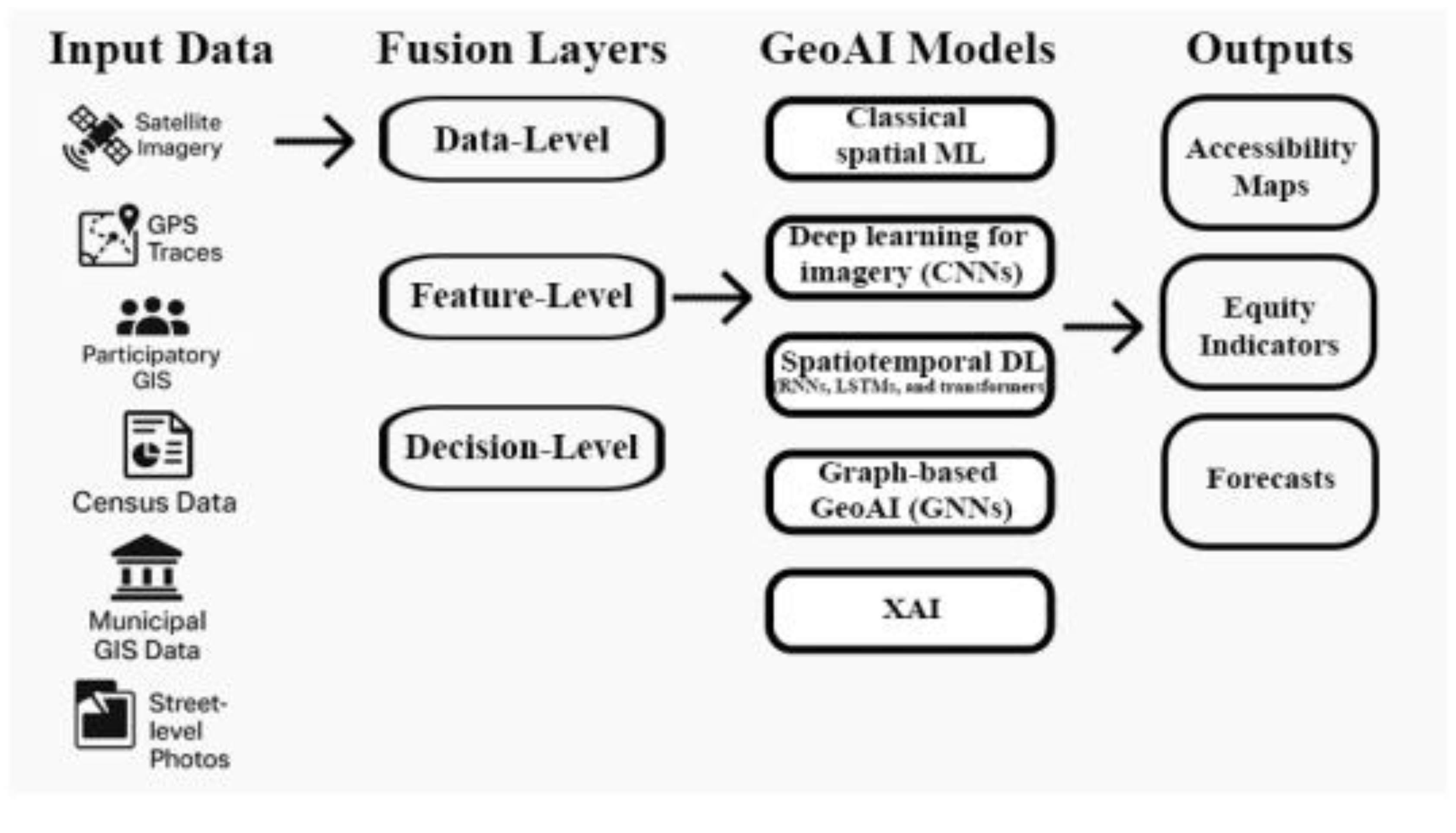
Table 2.
Key characteristics of multimodal GeoAI studies reviewed, including methodology, prediction task, data sources, and geographic scope.
Table 2.
Key characteristics of multimodal GeoAI studies reviewed, including methodology, prediction task, data sources, and geographic scope.
| Framework name | Core methodology |
Prediction target |
Geographic scope |
Data modalities combined |
Study |
|---|---|---|---|---|---|
| Hierarchical Evaluation Framework | DS-HRNet, a Detail-Strengthened High-Resolution Network (deep learning model) | Urban walkability | Wuhan, China | Multimodal data | 61 |
| Spatially Explicit Explainable GeoAI | GCN + GNNExplainer | Traffic volume prediction | Wuhan, China | Multimodal data | 62 |
| GT-LSTM | Attention mechanisms and RNNs |
Urban mobility patterns | Not specified |
Multi-modal urban transportation dataset |
63 |
| FusionTransNet | Graph neural networks | OD flows | Shenzhen and New York | Taxi GPS, shared bike, bus data | 64 |
| Matrix Trifactorization | Matrix factorization | Travel mode choice |
Santiago, Chile |
Mobile phone data, travel surveys, smart card data, OSM infrastructure | 65 |
| Software platform |
Not specified | Travel mode choice |
Urban areas (unspecified) | Survey data, GPS traces, weather, transport models, built environment | 66 |
| Late Fusion Network | CNNs and LSTMs with attention | OD flows | Urban areas (unspecified) | Bus transit records, temporal features | 67 |
| ST-MDF | Not specified | Demand forecasting | Medium to large cities | Taxi, bicycle rental, weather data | 68 |
| STKG | Knowledge graph completion |
Next POI prediction |
New York, Beijing, Shanghai | Foursquare check-ins, WeChat location data, POI categories |
69 |
| MDTP | Multi-source bridging using Sum and Concat | Demand forecasting | New York City, Chicago | Taxi and bike sharing data |
70 |
| GSABT | Graph sparse attention + bi-TCN | Joint multimodal traffic prediction | Not specified (3 real datasets) |
Multiple traffic modes (e.g., bus, taxi, bike) | 72 |
| STGATN | GCN + Bi-LSTM + weather attention + Transformer | Bike-sharing e-fence demand | Shenzhen, China (Nanshan District) | Bike usage, POI-based zones, weather | 73 |
| GAN-based taxi forecaster | GAN with RNN + CNN | Taxi demand | Wuhan, China | Taxi GPS, road network, weather, POIs | 74 |
| Low-dimensional bike demand model | Three-level clustering + regression |
Bike-sharing demand |
New York City | Bike trips, temperature, precipitation | 75 |
| Data-fusion mode choice (DAE+RF) | Stacking, denoising autoencoder + Random Forest |
Individual travel mode choice | Germany & Switzerland |
Travel diary surveys, socio-demographics, built environment | 76 |
| Smartphone-survey mode ID | SVM, GBDT | Trip mode (classification) |
Hangzhou, China | Smartphone GPS, survey labels, A-Map API | 77 |
| Integrated survey + Amap API | XGBoost, Random Forest + SHAP | Travel mode choice | Chinese city (not specified) |
Revealed preference survey, Amap path/time/cost | 78 |
| Stacking ML for mode choice | Stacking ensemble | Travel mode choice | Jinan, China | Large-scale travel survey, socio-demographics | 79 |
Table 3.
Mapping of Identified Gaps, Objectives, and Anticipated Impacts in Multimodal GeoAI for Inclusive Urban Mobility.
Table 3.
Mapping of Identified Gaps, Objectives, and Anticipated Impacts in Multimodal GeoAI for Inclusive Urban Mobility.
| Gap Type | What’s Missing | Thesis Objective / Proposed Solution | Expected Contribution |
|---|---|---|---|
| Population Gap | Global city bias; lack of inclusivity | Apply to medium/marginal cities with participatory data | Demonstrated GeoAI transferability to critical contexts |
| Methodological Gap | Accuracy focus, weak fairness/XAI integration | Embed equity-aware objectives, integrate XAI | Explainable, fairness-constrained GeoAI for actionable plans |
| Multimodal Integration | Heterogeneous, misaligned data | Develop adaptive multimodal fusion pipeline | Holistic equity assessment using multimodal data |
| Equity Optimization Gap | Equity only measured post-hoc | Formulate equity-aware loss functions | Moves equity from evaluation to optimization |
| Explainability/Auditability | Unstable XAI, lack of rigorous validation | Integrate policy-adaptive XAI, fairness auditing | Reliable, policy-ready equity validation |
| Reproducibility/Participation | Limited open workflows, little community voice | Open-source workflows, participatory validation | Procedural justice/transparency in GeoAI |
| Governance/Institutional | Siloed data custodianship, poor collaboration | Propose urban data trusts/multi-sector frameworks | Sustainable governance for equitable GeoAI/data use |
| Socioeconomic/Implementation | Limited real-world policy/scalability validation | Test GeoAI in diverse urban/policy contexts | Practical, scalable GeoAI impact on equity |
| Stakeholder Engagement | Weak participatory design/evaluation | Co-design and review with citizens, officials | Inclusive, socially embedded GeoAI implementations |
Disclaimer/Publisher’s Note: The statements, opinions and data contained in all publications are solely those of the individual author(s) and contributor(s) and not of MDPI and/or the editor(s). MDPI and/or the editor(s) disclaim responsibility for any injury to people or property resulting from any ideas, methods, instructions or products referred to in the content. |
© 2026 by the authors. Licensee MDPI, Basel, Switzerland. This article is an open access article distributed under the terms and conditions of the Creative Commons Attribution (CC BY) license (http://creativecommons.org/licenses/by/4.0/).
Copyright: This open access article is published under a Creative Commons CC BY 4.0 license, which permit the free download, distribution, and reuse, provided that the author and preprint are cited in any reuse.


