
Submitted:
02 February 2026
Posted:
03 February 2026
You are already at the latest version
Abstract
Submarine canyon-channel system plays a critical role as potential conduit for warm water upwelling in Antarctica, thereby influencing ice sheet stability. In this study, we identify 29 canyon-channel systems along the Adélie Land margin and conduct sys-tematic morphometric analysis of their length, width, depth, width-to-depth (W/D) ratio, and sinuosity. The results reveal pronounced differences in the distribution and morphological evolution of canyon–channel systems between the Adélie Depression and the Adélie Bank. We propose that these differences are primarily controlled by the shelf-slope topography, sediment supply, and ice sheet dynamic process. As the main catchment area of the Wilkes Subglacial Basin (WSB), the Adélie Depression is fed by a focused, high-flux supply of glacial debris, leading to the development of large-scale progradation wedges and mass transport deposits. These conditions promote the formation of extensive canyon–channel systems with elongated, tortuous, and dendritic morphologies. In contrast, canyon–channel systems on the Adélie Bank are smaller, more isolated, and irregularly distributed, reflecting dispersed and episodic sediment supply combined with strong bottom-current reworking. This study eluci-dates how canyon-channel system morphology responds to the topography, sedi-mentation, and ice dynamics in high-latitude glaciated margins, providing important constraints on sediment transport pathways and ice-sheet–ocean interactions in Antarctica.
Keywords:
canyon-channel system
; sediment supply
; topography
; Adélie Land
1. Introduction
Submarine canyon-channel systems serve as critical conduits for sediment transport and heat exchange along high-latitude continental margins[3,4,23]. Deeply incised into the Antarctic shelf and slope, these systems are particularly well-developed along the margins of Wilkes Land and Adélie Land [23].
Submarine canyon-channel system represent the primary pathways for downslope transport of glacial sediments, exerting a first-order control on continental-margin stratigraphy [42]. In addition, canyons incising the continental shelf facilitate the cascading of dense shelf water (DSW), which contributes to the formation and export of Antarctic Bottom Water [4,30]. Crucially, these systems also act as topographic corridors that enable the on-shelf transport of modified Circumpolar Deep Water (MCDW) toward ice-covered regions, enhancing basal melting of ice shelves and potentially destabilizing ice-sheet dynamics through the delivery of oceanic heat [32,37,42].
The East Antarctic Ice Sheet stores a sea-level equivalent of approximately 52 m [18,37,40]. Its vulnerability is strongly influenced by the geometry of subglacial basins and the configuration of submarine canyon-channel system that incise the continental shelf and slope [40]. As the largest marine-based catchment in East Antarctica, the WSB lies mainly below sea level, in contrast to other regions of the ice sheet[1,2] (Figure 1). This configuration renders it highly susceptible to warm-water intrusion and potential ice-sheet instability [25,46]. However, the geomorphic processes that control ocean connectivity to the basin remain poorly understood. In particular, a systematic analysis of morphometric variability and its genetic controls is lacking for the submarine canyon-channel system along the Adélie Land continental margin, which serves as the primary drainage conduit for ice streams from the WSB.
This study presents a detailed geomorphic analysis of the submarine canyon channel system along the Adélie Land continental margin, with a comparative focus on the contrasting domains of the Adélie Depression and the Adélie Bank. By integrating the IBCSO v2 bathymetric compilation [24], and seismic profiles from the WEGA project, we aim to: (a) quantify key morphometric param, such as canyon length, incision depth, width, width-to-depth (W/D) ratio, and sinuosity; (b) compare the scale and cross-sectional geometries of canyon-channel systems originating from the front of the Adélie Depression with those incising the front of the Adélie Bank; and (c) evaluate the role of glacial dynamics and sediment supply in driving the observed geomorphic differences, supported by regional seismic data, drill-site information, and topographic constraints.
2. Geological Setting
The Wilkes Land margin formed during the Jurassic/Cretaceous period as a result of extensional deformation during the rifting between Australia and Antarctica [10,20,22]. Superimposed on regional post-rift subsidence, late-stage extensional deformation formed a series of longitudinal troughs [1,2]. The Adélie Depression, located seaward of the Mertz Glacier Tongue, incises the continental shelf to depths exceeding 1,000 m and serves as the primary conduit for transporting ice stream from the WSB to the ocean [12] (Figure 1). Its southeastern flank is bounded by the Adélie Bank, a structural high composed of thinned continental crust that experienced mild flexural uplift during serpentinization of the continent-ocean transition zone [49].
The sedimentary sequence of the Adélie Land continental margin is a dual archive of both tectonic and climatic evolution [44]. These sedimentary layers are distinctly divided into syn-rift and post-rift sequences by major unconformities, recording the growth process of the continental margin [13,14]. Following the rift phase, the region entered a prolonged period of stable thermal subsidence, during which it received extensive hemipelagic turbidite deposits [21,43,48]. Since the gradual formation and expansion of the Antarctic ice sheet from the Eocene onwards, sedimentation has been primarily governed by glacial activity [14,47,48]. The repeated advances and retreats of Antarctic ice sheet have left a complex stratigraphic record on the shelf and continental slope, dominated by glacial deposits and gravity flow deposits [8,20].
The Adélie Bank is characterized by strata that are flat or very gently seaward-dipping (Eittreim et al., 1995; Figure 1), which are areas bypassed by the most recent ice streams and where grounded ice has been slow moving or relatively immobile [17,26]. The Adélie Depression, with water depths exceeding 800 m and located in front of the Mertz Glacier, provides a favorable site for the accumulation of highly MCDW and DSW [23]. The underlying saline water mass can overflow through canyons on the continental slope, merging into the deep circulation of the Australian-Antarctic Basin and becoming an important component of Antarctic bottom current within the global circulation [10,14]. Moreover, calving events of the adjacent Mertz Glacier Tongue can significantly alter the local hydrological structure and circulation patterns, further highlighting the sensitivity of ice-ocean processes in this region (Bijl et al., 2018).
3. Data and Methods
The geomorphological analyses in this study is based on the International Bathymetric Chart of the Southern Ocean Version 2 (IBCSO v2, with a spatial resolution of 500 m × 500 m; Arndt et al., 2022). Subglacial topographic data were obtained from the MEaSUREs BedMachine Antarctica, Version 3 [40] (also at a 500 m × 500 m spatial resolution). The seismic reflection data were acquired in SEG-Y format from the Antarctic Seismic Data Library System (SDLS; accessible at http://sdls.ogs.trieste.it).
A submarine canyon-channel system is here defined as an elongate, negative topographic feature that incises the continental shelf/slope, extends to the abyssal plain, and exceeds 10 km in total length. Systems were initially identified using the automated watershed delineation tool in Global Mapper, followed by manual refinement. A systematic morphometric analysis was performed on canyon-channel systems within the Adélie Bank and Adélie Depression regions. The measured parameters include: : (a) length, defined as the actual meandering distance of the channel; (b) straight length, representing the linear distance between the channel's head and terminus; (c) sinuosity index, calculated as the ratio of the system's actual length to its straight-line length; (d) width and depth, measured at cross-sections located at the head, middle, and lower sections of each system; and (e) width-to-depth (W/D) ratio, derived from the width and depth values obtained at each respective section. In addition, to comprehensively analyze the differences in the distribution of submarine canyon-channel systems, the slope of Adélie Land is calculated by the QGIS software. Seismic interpretation was conducted using Petrel software (Schlumberger), utilizing amplitude, internal seismic facies, reflection terminations, and geometry to identify sedimentary features and stratigraphic relationships.
4. Results
4.1. The Morphology of Canyon-Channel Systems
A total of 29 submarine canyon-channel systems were identified within the study area (16 in the Adélie Depression region and 13 in the Adélie Bank region, Table 1, Figure 2, Figure 3 and Figure 4). On average, the canyon-channel systems of the Adélie Depression are longer (mean:73.4 ± 68.7km, Table 1, Figure 2) and exhibit higher sinuosity (mean sinuosity index: 1.07± 0.05, Table 1, Figure 2). In contrast, those in the Adélie Bank are shorter (average: 62.1 km) and straighter (mean sinuosity index: 1.05). Moreover, systems in the Adélie Bank are consistently wider than those in the Depression across all segments (upper, middle, and lower), with the most pronounced difference occurring in the lower segment (mean width: 11.9 km vs. 8.7 km).
Following the classification of Harris and Whiteway (2011)[33], these systems are categorized into two confinement types: slope-confined, which are restricted to the continental slope (20 in total), and shelf-incised types, which cut into the continental shelf (9 in total). Based on length, we further classify them into three scales: Type 1 (> 100 km), Type 2 (> 40 km), and Type 3 (< 40 km). The detailed morphometric characteristics of the canyon channel systems in both regions are described below.
4.1.1. Canyon-Channel Systems at the Mouth of Adélie Depression
16 submarine canyon-channel systems were identified at the mouth of Adélie Depression (Figure 3, Table 1). These systems typically form a dendritic transport network, where smaller, upstream canyons (e.g., slope-confined types such as C1 and C2)—predominantly developed on the continental slope with lengths under 50 km—converge downstream into larger shelf-incised or slope-confined systems. Type 1 canyon-channel systems (C7, C9, C11, C13) range in length from 157 to 198 km (Table 1). Their widths measure 8–15 km at the head, 16–30 km in the middle, and 9–22 km in the lower section. Head incision depths vary substantially from 22 to 367 m and decrease markedly downstream; for example, in C7, depth declines from 367 m to 58 m. Sinuosity indices range from 1.04 to 1.15. The width-to-depth (W/D) ratio also varies considerably along the thalweg: except for C9, which shows a decrease from 0.36 to 0.14, all other systems exhibit a pronounced increase in W/D. Notably, C13 transitions from a V- to a U-shaped cross-section as its W/D ratio rises from 0.07 at the head to 0.38 in the lower section. Type 2 canyon-channel systems (C3, C6, C10, C12, C14, C15) range in length from 44 to 60 km. Head incision depths range widely from 22 to 345 m and follow divergent downstream trends: C14 deepens from 35 m to 80 m, whereas C6 shallows markedly from 345 m to 32 m. Sinuosity varies from 1.03 to 1.12. Changes in W/D ratio and cross-sectional shape are not uniform: in C15 the ratio decreases from 0.20 to 0.15, while in C6 it increases sharply from 0.02 to 0.19. Type 3 systems (C1, C2, C4, C5, C8, C16) range in length from 21.5 to 39 km, primarily developing on the upper continental slope (Table 1 and Figure 3). Head incision depths range from 23 to 192 m, with generally limited variation along the thalweg. Sinuosity is consistently low (1.03–1.09). Downstream changes in W/D ratio are modest: C2 increases from 0.07 to 0.20, while C16 remains stable around 0.14.
4.1.2. Canyon-Channel Systems in Front of Adélie Bank
Morphometric analysis of the Adélie Bank region identified 13 major submarine canyon-channels (C17–C29, Figure 4, Table 1). Most systems are single-branched; only three dendritic networks are present: one formed by C17, C18, and C19; another by C23, C24, and C26; and a third by C28 and C29 (Figure 4).
Type 1 canyon-channel systems (C19, C21, and C24) measure between 138 and 183 km in length. Their widths range from 10–17 km at the head, 8–29 km in the middle section, and 18–30 km toward the lower section (Figure 4, Table 1). Head incision depths vary from 69 to 169 m, and longitudinal depth profiles are complex, C21 deepens initially from 69 m to 141 m before shallowing to 46 m, whereas C24 deepens continuously along its thalweg from 133 m to 394 m and then to 111.6 m (Figure 4, Table 1). The sinuosity index of this group falls between 1.01 and 1.10. Downstream trends in the width-to-depth ratio also differ, as C19 and C24 show gradual increases, from 0.10 to 0.11 and from 0.08 to 0.16 respectively, while C21 exhibits a pronounced rise from 0.16 to 0.52. Type 2 canyon-channel systems (C20, C23, and C28) range from 40.4 to 71 km in length (Figure 4, Table 1). Their widths vary between 8–14 km at the head, 6–16 km in the midsection, and 6–12 km in the lower section. Head depths range from 34 to 189 m, and the down-canyon depth profiles differ markedly. For example, C28 deepens continuously from 34 m to 105 m and then to 207 m, whereas C20 shallows progressively from 120 m to 93 m and then to 36 m (Table 1). Sinuosity indices lie between 1.05 and 1.18. Down-canyon trends in W/D ratio also vary (Figure 4, Table 1).Type 3 canyon-channel systems (C17, C18, C22, C25, C26, C27, C29) have lengths ranging from 15.8 to 37.2 km, with widths of 4–8 km at the head, 5–14 km in the midsection, and 5–12 km in the lower section. The sinuosity indices of this group are very close to 1, ranging from 1.01 to 1.05. As in the other types, both incision depths and W/D ratios show diverse along-thalweg trends (Table 1).
4.2. Difference in Continental Margin Morphology Between the Adélie Depression and the Adélie Bank
Bathymetric data and seismic profiles (Figure 4 and Figure 5) reveal distinct topographic and sedimentary characteristics between the continental margins of the Adélie Depression and the Adélie Bank. The Adélie Depression region is characterized by a large-scale depression, with a maximum depth of approximately 340 m near the shelf edge (Figure 5d). The depression extends about 130 km parallel to the shelf edge and shows a clear trend of shallowing seaward (Figure 5d). The shelf break in this area is steep, with local slopes reaching up to 12° (Figure 5f). More notably, the continental slope fronting the depression is exceptionally steep, with the upper slope exceeding 7.62° (Figure 5c). This steep gradient produces a sharp transition in water depth from the shelf edge to the deep basin (Figure 5c), resulting in highly rugged and variable topography. In contrast, the Adélie Bank (corresponding to the profile areas shown in Figure 5b,e) exhibits a gentler morphology. Slopes at the shelf break are significantly lower than those in the depression, with a maximum of only ∼8° (Figure 5e). The continental slope fronting the bank is broadly gradual, and the maximum gradient on the upper slope is merely 1.99° (Figure 5b). As shown in the profile in Figure 5b, water depth increases gradually from the shelf edge to the deep basin, with minimal topographic variation, forming a wide and uniformly gentle slope.
Based on seismic reflection data and drilling data from the region in Integrated Ocean Drilling Program Expedition 318 [27], three discontinuities are identified in the Adélie Land continental margin: WL-U3, WL-U5, WL-U8, along with various types of sedimentary features. In Profile TH93-17SMG (refer to your figures), we observe a distinct progradation wedge above WL-U8 (CDP 3001-4001), and significant channel erosion is noted in the lower slope to continental rise area, mainly occurring above the WL-U5 discontinuity. Additionally, above the WL-U5 discontinuity, Mass Transport Deposits (MTDs) are prominently developed in the lower slope/rise region. These deposits appear as broadly tabular to lens-shaped bodies, with internally chaotic to semi-transparent structures, underlain by high-amplitude reflectors corresponding to strongly erosional surfaces. The largest MTD measures 400 ms TWT in thickness and 18 km in width, while the smallest is 500 ms TWT thick and 4 km wide (Figure 6). Additionally, an elongated drift deposit with an asymmetrically mounded geometry and laterally inclined edges is identified in the lower slope area, situated between two canyon-channel systems (Figure 6). In Profile TH93-08SMG, landward-migrating sediment waves are clearly developed above the WL-U8 interface in the continental rise area (CDP 1297–2200). The reflection structure is primarily parallel and wavy, with a thickness of 600 ms (TWT) and a width of 10 km. Significant slump deposits were observed on the slope (CDP 3000-3500), with small MTDs found at the lower end of the slump (~thickness of 300 ms and width of 4 km). Additionally, multiple phases of channel burial and migration are observed above the WL-U8 discontinuity in the lower slope to continental rise area (near CDP 2592 and 649).
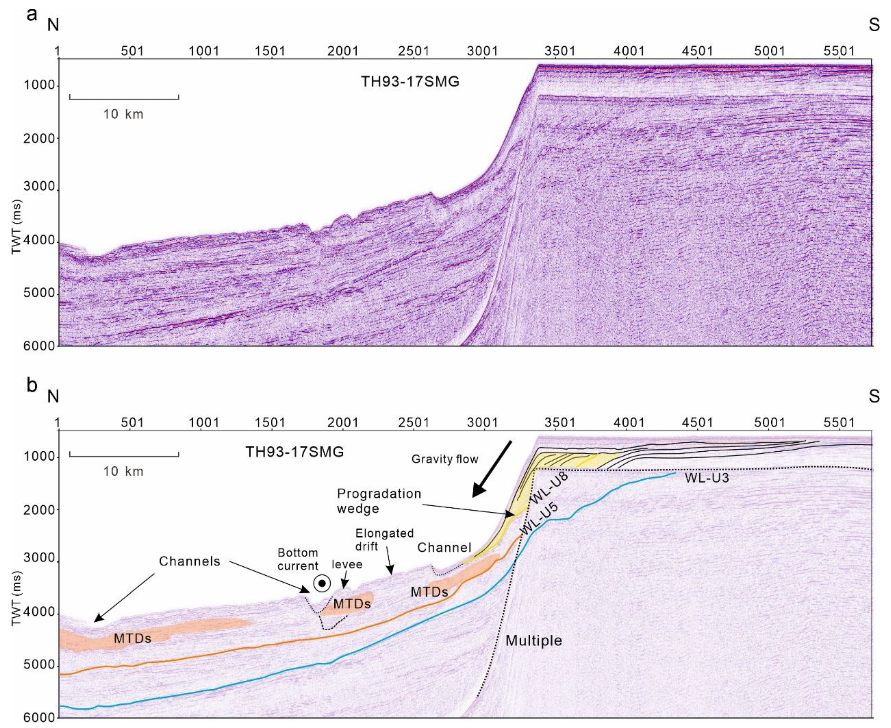
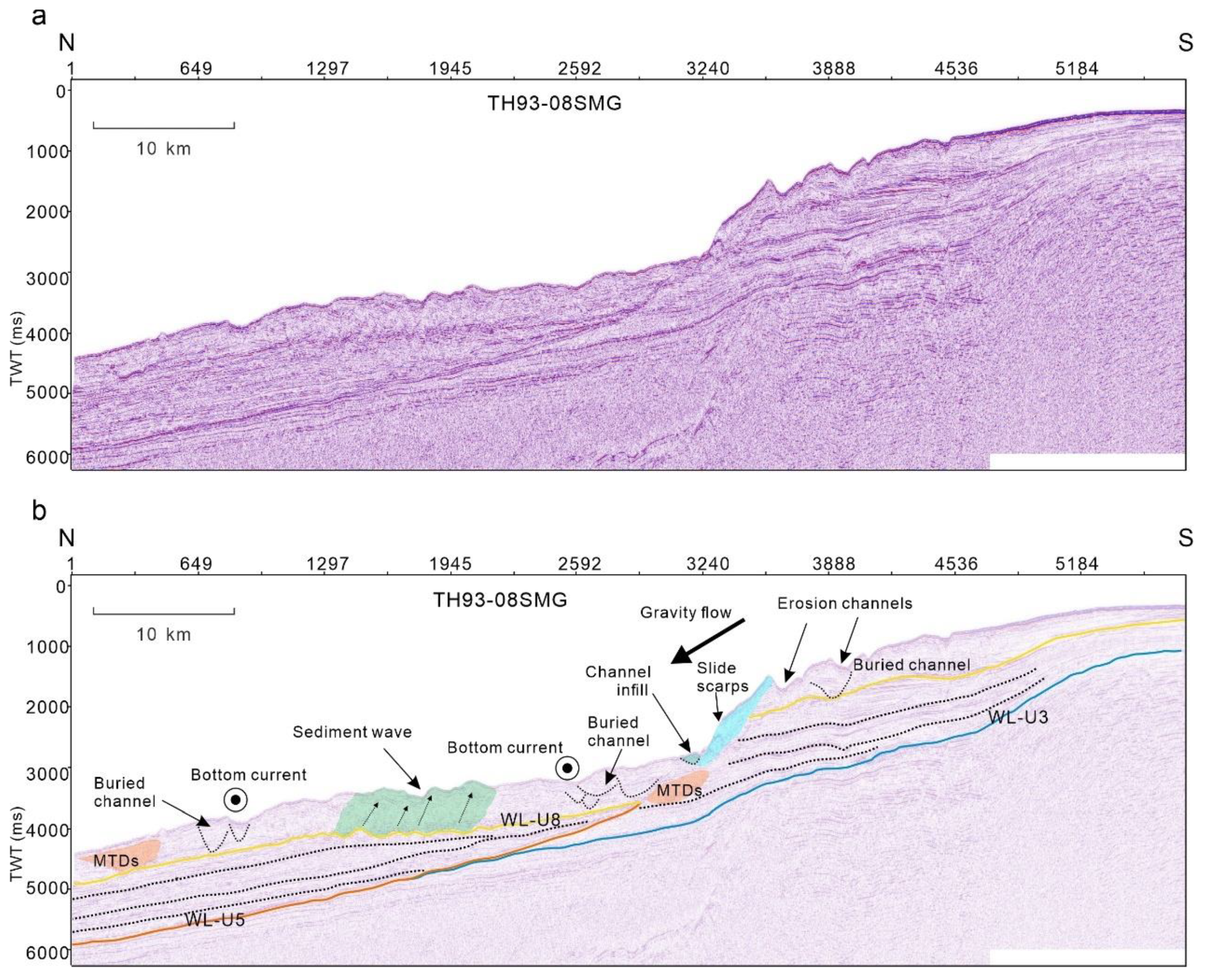
Figure 6.
Seismic profile and interpretation showing major Unconformity, channels, mass transport deposits (MTDs), progradation wedge, elongated drift, and direction of Bottom water and gravity flow. The location of this seismic line is displayed in Figure 1a. TWT, two-way travel time.
Figure 6.
Seismic profile and interpretation showing major Unconformity, channels, mass transport deposits (MTDs), progradation wedge, elongated drift, and direction of Bottom water and gravity flow. The location of this seismic line is displayed in Figure 1a. TWT, two-way travel time.
Figure 7.
Seismic profile and interpretation showing major Unconformity, channels, sediment waves, mass transport deposits (MTDs), drift, slide scarps, channels, channel infill, and direction of Bottom water and gravity flow. The location of this seismic line is displayed in Figure 1a. TWT, two-way travel time.
5. Discussion
5.1. Influence of Shelf-Slope Topography on Submarine Canyon-Channel Systems
The continental shelf and slope of the Adélie Depression and the Adélie Bank exhibit significant morphological differences (Figure 1 and Figure 6, Table 1). The shelf in the depression is characterized by glacially excavated troughs, while the bank forms a relatively elevated shallow platform. Correspondingly, the slope of the depression is notably steeper, with a more pronounced gradient change at the shelf edge. These topographic differences are reflected in the morphology of the submarine canyon-channel systems developed in each region (Figure 2, Figure 3, Figure 4 and Figure 8, Table 1). The canyon-channel systems formed within the Adélie Depression typically exhibit a more dendritic structure and greater longitudinal extent (Figure 8). In these systems, the W/D ratio of the main trunk canyon-channel generally shows an increasing trend from upstream to downstream (Table 1). In contrast, the canyon-channel systems located at the front of the Adélie Bank are more isolated. They are characterized by shorter lengths, and the W/D ratio within individual systems fluctuates irregularly along their thalwegs (Figure 4 and Figure 8, Table 1).
The morphological differences along the continental margin likely explain the divergent development of submarine canyon-channel systems in the two regions. The deep glacial trough developed in Adélie Depression forms a convergent sediment feeder trough [15,29]. And its steep continental slope provides substantial potential energy for gravity flows [31]. This topographic setting directly facilitates the development of extensive, dendritic canyon-channel networks. Large canyons formed under these conditions (e.g., C7, C13) reach lengths of 185–198 km, and their width-to-depth (W/D) ratios show a systematic and marked downstream increase (e.g., C13 from 0.07 to 0.38), indicating a pronounced widening and shallowing trend. This morphological evolution corresponds with the large-scale mass-transport deposits (MTDs) identified in seismic data downslope (Figure 6). These deposits record the process of high-energy gravity flows losing energy abruptly at the base of the steep slope, resulting in deposition accompanied by lateral accretion, consistent with the typical gravity-flow-dominated model [7] (Figure 8a). In contrast, the shallow bank and gentle slope topography at the front of the Adélie Bank result in dispersed sediment supply and lower energy of gravity flows (Figure 8b). Consequently, canyon-channel systems here are smaller in scale, dominated by relatively isolated, small- to medium-sized canyons, and lack well-developed dendritic networks (Figure 8b). Their morphological param, particularly the along-path variation in W/D ratios, exhibit high diversity (e.g., C21 shows a significant increase while C28 decreases sharply), with no uniform trend. This reflects that, in the gentle slope setting, canyon-channel system morphology is more controlled by local factors [16,35] (such as the intensity of bottom-current reworking and original micro-topography). Their formation process results from the interplay or superimposed modification by various actions of gravity flows and bottom currents [34]. Ultimately, differences in shelf-slope topography, by controlling the concentration of sediment supply and the initial energy of gravity flows, fundamentally determine the distribution and evolution of submarine canyon-channel systems.
5.2. Ice-Sheet Dynamics and Sediment Supply on the Evolution of Submarine Canyon-Channel Systems
Adélie Land is situated at the forefront of the WSB, the largest marine-based ice sheet catchment in East Antarctica [18]. The substantial ice melt and ice stream discharge in this region generate dense downslope flows along the continental margin [5]. These dense turbidity currents are likely responsible for the formation of the submarine canyon-channel systems observed on the Adélie Land continental margin [30]. Due to contrasts in topography and setting, sediment sources and supply rates along the Adélie Depression and the Adélie Bank exhibit significant variations due to differences in topography and location [10,20] (Figure 8), potentially leading to diverse morphological characteristics of submarine canyon-channel systems, such as length, width, and W/D ratios [6,7,33].
The progradation pattern of glaciated margins is typically associated with sediment supplied by ice sheets or ice streams during glacial maxima [38]. A distinct progradation wedge is observed in the upper slope area of Adélie Depression, providing direct evidence of concentrated sediment supply and the episodic, large-scale seaward progradation of deposits [9] (Figure 4 and Figure 5, Figure 8c). The channel-levee depositional system at the front of Adélie Depression is primarily formed by sediment transport via downslope turbidity currents and is subsequently reworked by weak to moderate bottom currents [39,51] (Figure 6, Figure 8c). During deglacial and interglacial periods, the rapid retreat or rebound of ice sheets alter pressure fields and hydrology, triggering massive block slides of glacial till and the formation of large-scale MTDs [34]. The emplacement of MTDs initially creates negative topography or slump scars on the continental slope. Along these weak zones flow sustained, high-frequency, and high-density turbidity currents generated by meltwater and sediment resuspension [19,41]. With erosive power far exceeding that of normal sedimentation, these currents intensely scour the valley floor and sidewalls through headward and lateral incision, with erosion being particularly pronounced along the steep discontinuities formed by the MTDs themselves [45]. This process ultimately leads to the formation of large, extensive canyon-channel systems (e.g., C7 extends 198 km, and C9 extends 181 km).
In contrast to Adélie Depression, the Adélie Bank lacks a concentrated and abundant sediment supply, which is sourced from extensive bank, resulting in a dispersed, multi-point input [27,50] (Figure 8d). These discrete source areas deliver sediments of varying grain sizes and volumes, leading to differences in the properties and fluxes of material entering individual canyon-channel systems [11,50]. Furthermore, the landslides and MTDs observed in in the profile TH93-08MSG indicate that sediments may be introduced through various mechanisms (Figure 7), such as small-scale landslides, intermittent meltwater runoff, or suspension transport by currents [5,28,36]. This discontinuous, pulsed supply causes alternating periods of depositional events and erosional events within the canyon-channel systems over time and space. Additionally, the presence of extensive landward-migrating sediment waves indicates that bottom currents play a dominant role in current activity in this area (Figure 7), interacting with gravity flows along the margin of the Adélie Bank [34,44]. Different processes may temporarily dominate in various canyon-channel system sections, creating differentiated erosion-deposition balances that lead to irregular fluctuations in W/D ratios along the thalweg (Figure 8d).
6. Conclusions
Based on the integrated bathymetric data and seismic profiles, this study systematically analyzes the significant differences in morphology, distribution, and genetic mechanisms of submarine canyon-channel systems between the Adélie Depression and the Adélie Bank. The main conclusions are as follows:
(a) The canyon systems in the Adélie Depression are generally longer, more sinuous, and exhibit dendritic networks, with width-to-depth ratios typically increasing downstream. In contrast, canyon systems on the Adélie Bank are shorter, straighter, predominantly consist of isolated single branches, and show irregular along-channel variations in width-to-depth ratios. (b) The steep continental slope (with gradients >12°) in the Depression favor the acceleration of gravity flows and enhance incision, promoting the development and elongation of large canyon systems. In comparison, the gentle slope of the Bank (maximum gradient ~1.99°) and uniform topography restrict channel convergence and longitudinal extension. (c) As the primary outlet of the subglacial basin, the Depression receives concentrated and sustained glacial sediment input. During deglacial periods, frequent mass failures and high-density turbidity currents shape large canyon-channel systems. Conversely, sediment supply to the Bank is dispersed, dominated by small-scale landslides, intermittent meltwater runoff, and suspended transport. Depositional processes here are significantly reworked by bottom currents, leading to the development of extensive landward-migrating sediment waves. This study underscores the critical control exerted by shelf-slope topography and sediment supply on high latitude canyon channel evolution, providing key insights into glacial marine sedimentation and ice sheet–ocean interactions in Antarctica.
Author Contributions
Conceptualization, methodology, and software, Hua Huang; formal analysis, writing—original draft preparation, Hua Huang; writing—review and editing, Fanchang Zeng; visualization, supervision, project administration and funding acquisition, Xiaoxia Huang. All authors have read and agreed to the published version of the manuscript.
Funding
This research was funded by The National Natural Science Foundation of China (42476270), and the International Partnership Program of Chinese Academy of Sciences (120GJHZ2022039FN), and Pioneer Hundred Talents Program (Y910091001) Chinese Academy of Sciences (CAS).
Data Availability Statement
The bathymetric data used for channel identification in the study is available through Dorschel et al., 2022 (The International Bathymetric Chart of the Southern Ocean Version 2, https://doi.org/10.1038/s41597-022-01366-7.) Seismic-reflection profiles that were used in this study are available from the Antarctic Seismic Data Library System (SDLS) in SEG-Y format (http://sdls.ogs.trieste.it). The data of submarine channel morphometric parameters supporting this study is available in the supporting information during peer review. Upon acceptance, the complete dataset will be permanently archived in Zenodo (https://zenodo.org/) with a persistent DOI.
Acknowledgments
We thank the finance supports of The National Natural Science Foundation of China (42476270), and the International Partnership Program of Chinese Academy of Sciences (120GJHZ2022039FN), and Pioneer Hundred Talents Program (Y910091001) Chinese Academy of Sciences (CAS).
Conflicts of Interest
All authors have contributed significantly and have read and approved the submitted version. We declare no competing financial interests or personal relationships that could have influenced this work.
References
- Aitken, A.R.A.; Li, L.; Kulessa, B.; Schroeder, D.; Jordan, T.A.; Whittaker, J.M.; Anandakrishnan, S.; Dawson, E.J.; Wiens, D.A.; Eisen, O.; Siegert, M.J. Antarctic Sedimentary Basins and Their Influence on Ice-Sheet Dynamics. Reviews of Geophysics 2023, 61(3), e2021RG000767. [Google Scholar] [CrossRef]
- Aitken, A.R.A.; Young, D.A.; Ferraccioli, F.; Betts, P.G.; Greenbaum, J.S.; Richter, T.G.; Roberts, J.L.; Blankenship, D.D.; Siegert, M.J. The subglacial geology of Wilkes Land, East Antarctica. Geophysical Research Letters 2014, 41(7), 2390–2400. [Google Scholar] [CrossRef]
- Almeida, N.M.D.; Vital, H.; Gomes, M.P. Morphology of submarine canyons along the continental margin of the Potiguar Basin, NE Brazil. Marine and Petroleum Geology 2015, 68, 307–324. [Google Scholar] [CrossRef]
- Amblas, D.; Dowdeswell, J.A. Physiographic influences on dense shelf-water cascading down the Antarctic continental slope. Earth-Science Reviews 2018, 185, 887–900. [Google Scholar] [CrossRef]
- Behrens, B.; Miyairi, Y.; Sproson, A.D.; Yamane, M.; Yokoyama, Y. Meltwater discharge during the Holocene from the Wilkes subglacial basin revealed by beryllium isotope analysis of marine sediments. Journal of Quaternary Science 2019, 34(8), 603–608. [Google Scholar] [CrossRef]
- Bernhardt, A.; Schwanghart, W. Where and Why Do Submarine Canyons Remain Connected to the Shore During Sea-Level Rise? Insights From Global Topographic Analysis and Bayesian Regression. Geophysical Research Letters 2021, 48(10), e2020GL092234. [Google Scholar] [CrossRef]
- Bernhardt, A.; Schwanghart, W. Seafloor slopes control submarine canyon distribution: A global analysis. Science Advances 2025. [Google Scholar] [CrossRef]
- Bijl, P.K.; Houben, A.J.P.; Hartman, J.D.; Pross, J.; Salabarnada, A.; Escutia, C.; Sangiorgi, F. Paleoceanography and ice sheet variability offshore Wilkes Land, Antarctica: Part 2. Insights from Oligocene-Miocene dinoflagellate cyst assemblages. Climate of the Past 2018, 14(7), 1015–1033. [Google Scholar] [CrossRef]
- Bührig, L.H.; Colombera, L.; Patacci, M.; Mountney, N.P.; McCaffrey, W.D. A global analysis of controls on submarine-canyon geomorphology. Earth-Science Reviews 2022, 233, 104150. [Google Scholar] [CrossRef]
- Caburlotto, A.; De Santis, L.; Zanolla, C.; Camerlenghi, A.; Dix, J.K. New insights into Quaternary glacial dynamic changes on the George V Land continental margin (East Antarctica). Quaternary Science Reviews 2006, 25(21–22), 3029–3049. [Google Scholar] [CrossRef]
- Caburlotto, A.; Lucchi, R.G.; De Santis, L.; Macrì, P; Tolotti, R. Sedimentary processes on the Wilkes Land continental rise reflect changes in glacial dynamic and bottom water flow. International Journal of Earth Sciences 2010, 99(4), 909–926. [Google Scholar] [CrossRef]
- Carr, S.A.; Orcutt, B.N.; Mandernack, K.W.; Spear, J.R. Abundant Atribacteria in deep marine sediment from the Adélie Basin, Antarctica. Frontiers in Microbiology 2015, 6, 872. [Google Scholar] [CrossRef] [PubMed]
- Close, D.I.; Stagg, H.M.J.; O’Brien, P.E. Seismic stratigraphy and sediment distribution on the Wilkes Land and Terre Adélie margins, East Antarctica. Marine Geology 2007, 239(1–2), 33–57. [Google Scholar] [CrossRef]
- Close, D.I.; Watts, A.B.; Stagg, H.M.J. A marine geophysical study of the Wilkes Land rifted continental margin, Antarctica. Geophysical Journal International 2009, 177(2), 430–450. [Google Scholar] [CrossRef]
- Cofaigh, C.Ó.; Taylor, J.; Dowdeswell, J.A.; Pudsey, C.J. Palaeo-ice streams, trough mouth fans and high-latitude continental slope sedimentation. Boreas 2003, 32(1), 37–55. [Google Scholar] [CrossRef]
- Conte, R.; Rebesco, M.; De Santis, L.; Colleoni, F.; Bensi, M.; Bergamasco, A.; Kovacevic, V.; Gales, J.; Zgur, F.; Accettella, D.; De Steur, L.; Ursella, L.; McKay, R.; Kim, S.; Lucchi, R.G. Bottom current control on sediment deposition between the Iselin Bank and the Hillary Canyon (Antarctica) since the late Miocene: An integrated seismic-oceanographic approach. Deep Sea Research Part I: Oceanographic Research Papers 2021, 176, 103606. [Google Scholar] [CrossRef]
- Contreras, L.; Pross, J.; Bijl, P.K.; Koutsodendris, A.; Raine, J.I.; van de Schootbrugge, B.; Brinkhuis, H. Early to middle Eocene vegetation dynamics at the Wilkes Land margin (Antarctica). Review of Palaeobotany and Palynology 2013, 197, 119–142. [Google Scholar] [CrossRef]
- Cook, C.; van de Flierdt, T.; Williams, T.; Hemming, S.R.; Pierce, E.L.; Escutia, C.; González, J.J.; Jimenez-Espejo, F.J.; Mckay, R.M.; Patterson, M.O.; Passchier, S.; Tauxe, L. and the IODP Expedition 318 Scientists Ice sheet dynamics in the vicinity of the Wilkes subglacial basin during the Pliocene. 2011 American Geophysical Union Fall Meeting, San Francisco, CA, 2011, December 5. [Google Scholar]
- Corella, J.P.; Loizeau, J.-L.; Kremer, K.; Hilbe, M.; Gerard, J.; Le Dantec, N.; Stark, N.; González-Quijano, M.; Girardclos, S. The role of mass-transport deposits and turbidites in shaping modern lacustrine deepwater channels. Marine and Petroleum Geology 2016, 77, 515–525. [Google Scholar] [CrossRef]
- Crotti, I.; Quiquet, A.; Landais, A.; Stenni, B.; Wilson, D.J.; Severi, M.; Mulvaney, R.; Wilhelms, F.; Barbante, C.; Frezzotti, M. Wilkes subglacial basin ice sheet response to Southern Ocean warming during late Pleistocene interglacials. Nature Communications 2022, 13(1), 5328. [Google Scholar] [CrossRef]
- Donda, F.; Brancolini, G.; O’Brien, P.E.; De Santis, L.; Escutia, C. Sedimentary processes in the Wilkes Land margin: A record of the Cenozoic East Antarctic Ice Sheet evolution. Journal of the Geological Society 2007, 164(1), 243–256. [Google Scholar] [CrossRef]
- Donda, F.; O’Brien, P.E.; De Santis, L.; Rebesco, M.; Brancolini, G. Mass wasting processes in the Western Wilkes Land margin: Possible implications for East Antarctic glacial history. Palaeogeography, Palaeoclimatology, Palaeoecology 2008, 260(1–2), 77–91. [Google Scholar] [CrossRef]
- Donda, F.; Rebesco, M.; Kovacevic, V.; Silvano, A.; Bensi, M.; De Santis, L.; Rosenthal, Y.; Torricella, F.; Baradello, L.; Gei, D.; Leventer, A.; Post, A.; Leitchenkov, G.; Noble, T.; Zgur, F.; Cova, A.; O’Brien, P.; Romeo, R. Footprint of sustained poleward warm water flow within East Antarctic submarine canyons. Nature Communications 2024, 15(1), 6028. [Google Scholar] [CrossRef] [PubMed]
- Dorschel, B.; Hehemann, L.; Viquerat, S.; Warnke, F.; Dreutter, S.; Tenberge, Y.S.; Accettella, D.; An, L.; Barrios, F.; Bazhenova, E.; Black, J.; Bohoyo, F.; Davey, C.; De Santis, L.; Dotti, C.E.; Fremand, A.C.; Fretwell, P.T.; Gales, J.A.; Gao, J.; Arndt, J.E. The International Bathymetric Chart of the Southern Ocean Version 2. Scientific Data 2022, 9(1), 275. [Google Scholar] [CrossRef] [PubMed]
- Duncan, B.; McKay, R.; Levy, R.; Naish, T.; Prebble, J.G.; Sangiorgi, F.; Krishnan, S.; Hoem, F.; Clowes, C.; Dunkley Jones, T.; Gasson, E.; Kraus, C.; Kulhanek, D.K.; Meyers, S.R.; Moossen, H.; Warren, C.; Willmott, V.; Ventura, G.T.; Bendle, J. Climatic and tectonic drivers of late Oligocene Antarctic ice volume. Nature Geoscience 2022, 15(10), 819–825. [Google Scholar] [CrossRef]
- Escutia Dotti, C.; Brinkhuis, H.; Dunbar, R.; Klaus, A. and the IODP Wilkes Land Expedition 318 Science Party Team Cenozoic ice sheet history from sediments recovered from the Wilkes Land margin: IODP Expedition 318. 2010 Scientific Committee on Antarctic Research Open Science Conference, Buenos Aires, Argentina, 2010, August 3. [Google Scholar]
- Expedition 318 Scientists. Wilkes Land Glacial History: Cenozoic East Antarctic Ice Sheet evolution from Wilkes Land margin sediments. Integrated Ocean Drilling Program Preliminary Report 2010, 318. [Google Scholar] [CrossRef]
- Gales, J.A.; Leat, P.T.; Larter, R.D.; Kuhn, G.; Hillenbrand, C.-D.; Graham, A.G.C.; Mitchell, N.C.; Tate, A.J.; Buys, G.B.; Jokat, W. Large-scale submarine landslides, channel and gully systems on the southern Weddell Sea margin, Antarctica. Marine Geology 2014, 348, 73–87. [Google Scholar] [CrossRef]
- Gales, J.; Hillenbrand, C.-D.; Larter, R.; Laberg, J.S.; Melles, M.; Benetti, S.; Passchier, S. Processes influencing differences in Arctic and Antarctic trough mouth fan sedimentology. Geological Society, London, Special Publications 2019, 475(1), 203–221. [Google Scholar] [CrossRef]
- Gales, J.; Rebesco, M.; De Santis, L.; Bergamasco, A.; Colleoni, F.; Kim, S.; Accettella, D.; Kovacevic, V.; Liu, Y.; Olivo, E.; Colizza, E.; Florindo-Lopez, C.; Zgur, F.; McKay, R. Role of dense shelf water in the development of Antarctic submarine canyon morphology. Geomorphology 2021, 372, 107453. [Google Scholar] [CrossRef]
- Gordon, A.L.; Orsi, A.H.; Muench, R.; Huber, B.A.; Zambianchi, E.; Visbeck, M. Western Ross Sea continental slope gravity currents. Deep Sea Research Part II: Topical Studies in Oceanography 2009, 56(13–14), 796–817. [Google Scholar] [CrossRef]
- Greenbaum, J.S.; Blankenship, D.D.; Young, D.A.; Richter, T.G.; Roberts, J.L.; Aitken, A.R.A.; Legresy, B.; Schroeder, D.M.; Warner, R.C.; Van Ommen, T.D.; Siegert, M.J. Ocean access to a cavity beneath Totten Glacier in East Antarctica. Nature Geoscience 2015, 8(4), 294–298. [Google Scholar] [CrossRef]
- Harris, P.T.; Whiteway, T. Global distribution of large submarine canyons: Geomorphic differences between active and passive continental margins. Marine Geology 2011, 285(1–4), 69–86. [Google Scholar] [CrossRef]
- Huang, X.; Bernhardt, A.; De Santis, L.; Wu, S.; Leitchenkov, G.; Harris, P.; O’Brien, P. Depositional and erosional signatures in sedimentary successions on the continental slope and rise off Prydz Bay, East Antarctica– implications for Pliocene paleoclimate. Marine Geology 2020, 430, 106339. [Google Scholar] [CrossRef]
- Huang, X.; Stärz, M.; Gohl, K.; Knorr, G.; Lohmann, G. Impact of Weddell Sea shelf progradation on Antarctic bottom water formation during the Miocene: MIOCENE ANTARCTIC BOTTOM WATER FORMATION. Paleoceanography 2017, 32(3), 304–317. [Google Scholar] [CrossRef]
- Jaijel, R.; Biton, E.; Weinstein, Y.; Ozer, T.; Katz, T. Observations of turbidity currents in a small, slope-confined submarine canyon in the Eastern Mediterranean Sea. Earth and Planetary Science Letters 2023, 604, 118008. [Google Scholar] [CrossRef]
- Lin, Y.; Yang, Q.; Shi, Q.; Nakayama, Y.; Chen, D. A Volume-Conserved Approach to Estimating Sea-Ice Production in Antarctic Polynyas. Geophysical Research Letters 2023, 50(4), e2022GL101859. [Google Scholar] [CrossRef]
- Liu, S.; Yang, C.; Yin, S.; Zhuo, H.; Su, M.; Luo, K.; Xu, Z.; Zhu, R.; Liang, Z. Deep-water sedimentary systems and tectono–sedimentary interactions on the oblique convergent margin in Antarctica. Sedimentology 2023, 70(5), 1353–1378. [Google Scholar] [CrossRef]
- Michels, K.H.; Kuhn, G.; Hillenbrand, C.-D.; Diekmann, B.; FÜtterer, D.K.; Grobe, H.; Uenzelmann-Neben, G. The southern Weddell Sea: Combined contourite-turbidite sedimentation at the southeastern margin of the Weddell Gyre. Geological Society, London, Memoirs 2002, 22(1), 305–323. [Google Scholar] [CrossRef]
- Morlighem, M.; Rignot, E.; Binder, T.; Blankenship, D.; Drews, R.; Eagles, G.; Eisen, O.; Ferraccioli, F.; Forsberg, R.; Fretwell, P.; Goel, V.; Greenbaum, J.S.; Gudmundsson, H.; Guo, J.; Helm, V.; Hofstede, C.; Howat, I.; Humbert, A.; Jokat, W.; Young, D.A. Deep glacial troughs and stabilizing ridges unveiled beneath the margins of the Antarctic ice sheet. Nature Geoscience 2020, 13(2), 132–137. [Google Scholar] [CrossRef]
- Nwoko, J.; Kane, I.; Huuse, M. Mass transport deposit (MTD) relief as a control on post-MTD sedimentation: Insights from the Taranaki Basin, offshore New Zealand. Marine and Petroleum Geology 2020, 120, 104489. [Google Scholar] [CrossRef]
- O’Brien, P.E.; Post, A.L.; Edwards, S.; Martin, T.; Caburlotto, A.; Donda, F.; Leitchenkov, G.; Romeo, R.; Duffy, M.; Evangelinos, D.; Holder, L.; Leventer, A.; López-Quirós, A.; Opdyke, B.N.; Armand, L.K. Continental slope and rise geomorphology seaward of the Totten Glacier, East Antarctica (112°E-122°E). Marine Geology 2020, 427, 106221. [Google Scholar] [CrossRef]
- Passchier, S.; Ciarletta, D.J.; Henao, V.; Sekkas, V. Sedimentary processes and facies on a high-latitude passive continental margin, Wilkes Land, East Antarctica. Glaciated Margins; the Sedimentary and Geophysical Archive 2018, 475(1), 181–201. [Google Scholar] [CrossRef]
- Presti, M.; Barbara, L.; Denis, D.; Schmidt, S.; De Santis, L.; Crosta, X. Sediment delivery and depositional patterns off Adélie Land (East Antarctica) in relation to late Quaternary climatic cycles. Marine Geology 2011, 284(1–4), 96–113. [Google Scholar] [CrossRef]
- Qin, Z.; Wu, S.; Wang, D.; Li, W.; Gong, S.; Mi, L.; Spence, G. Mass transport deposits and processes in the north slope of the Xisha Trough, northern South China Sea. Acta Oceanologica Sinica 2015, 34(9), 117–125. [Google Scholar] [CrossRef]
- Naish, T.R.; Duncan, B.; Levy, R.; M McKay, R.; Escutia, C.; De Santis, L.; Colleoni, F.; G.W. Gasson, E.M.; DeConto, R.; Wilson, G. Antarctic Ice Sheet dynamics during the Late Oligocene and Early Miocene: Climatic conundrums revisited. In Antarctic Climate Evolution; Elsevier, 2022; pp. 363–387. [Google Scholar] [CrossRef]
- Sangiorgi, F.; Bijl, P.K.; Passchier, S.; Salzmann, U.; Schouten, S.; McKay, R.; Cody, R.D.; Pross, J.; van de Flierdt, T.; Bohaty, S.M.; Levy, R.; Williams, T.; Escutia, C.; Brinkhuis, H. Southern Ocean warming and Wilkes Land ice sheet retreat during the mid-Miocene. Nature Communications 2018, 9(1), 317. [Google Scholar] [CrossRef] [PubMed]
- Santis, L.D.; Brancolini, G.; Donda, F. Seismo-stratigraphic analysis of the Wilkes Land continental margin (East Antarctica): Influence of glacially driven processes on the Cenozoic deposition. Deep Sea Research Part II: Topical Studies in Oceanography 2003, 50(8–9), 1563–1594. [Google Scholar] [CrossRef]
- Tauxe, L.; Sugisaki, S.; Jiménez-Espejo, F.; Escutia, C.; Cook, C.P.; van de Flierdt, T.; Iwai, M. Geology of the Wilkes Land sub-basin and stability of the East Antarctic ice sheet: Insights from rock magnetism at IODP Site U1361. Earth and Planetary Science Letters 2015, 412, 61–69. [Google Scholar] [CrossRef]
- Tooze, S.; Halpin, J.A.; Noble, T.L.; Chase, Z.; O’Brien, P.E.; Armand, L. Scratching the Surface: A Marine Sediment Provenance Record From the Continental Slope of Central Wilkes Land, East Antarctica. Geochemistry, Geophysics, Geosystems 2020, 21(11), e2020GC009156. [Google Scholar] [CrossRef]
- Yin, S.; Hernández-Molina, F.J.; Miramontes, E.; Shen, Z.; Yang, C.; Gao, J.; Liu, S.; Li, J. Sequential bedform development in mixed turbidite–contourite systems: An example from the Cosmonaut Sea, East Antarctica. Geomorphology 2022, 410, 108287. [Google Scholar] [CrossRef]
Figure 1.
Study area. (a) The bathymetry map and (b) subglacial topography of the Adélie Land. (c) the location of study area in Antarctica (red tangle). (d) slope map of Adélie land.
Figure 1.
Study area. (a) The bathymetry map and (b) subglacial topography of the Adélie Land. (c) the location of study area in Antarctica (red tangle). (d) slope map of Adélie land.
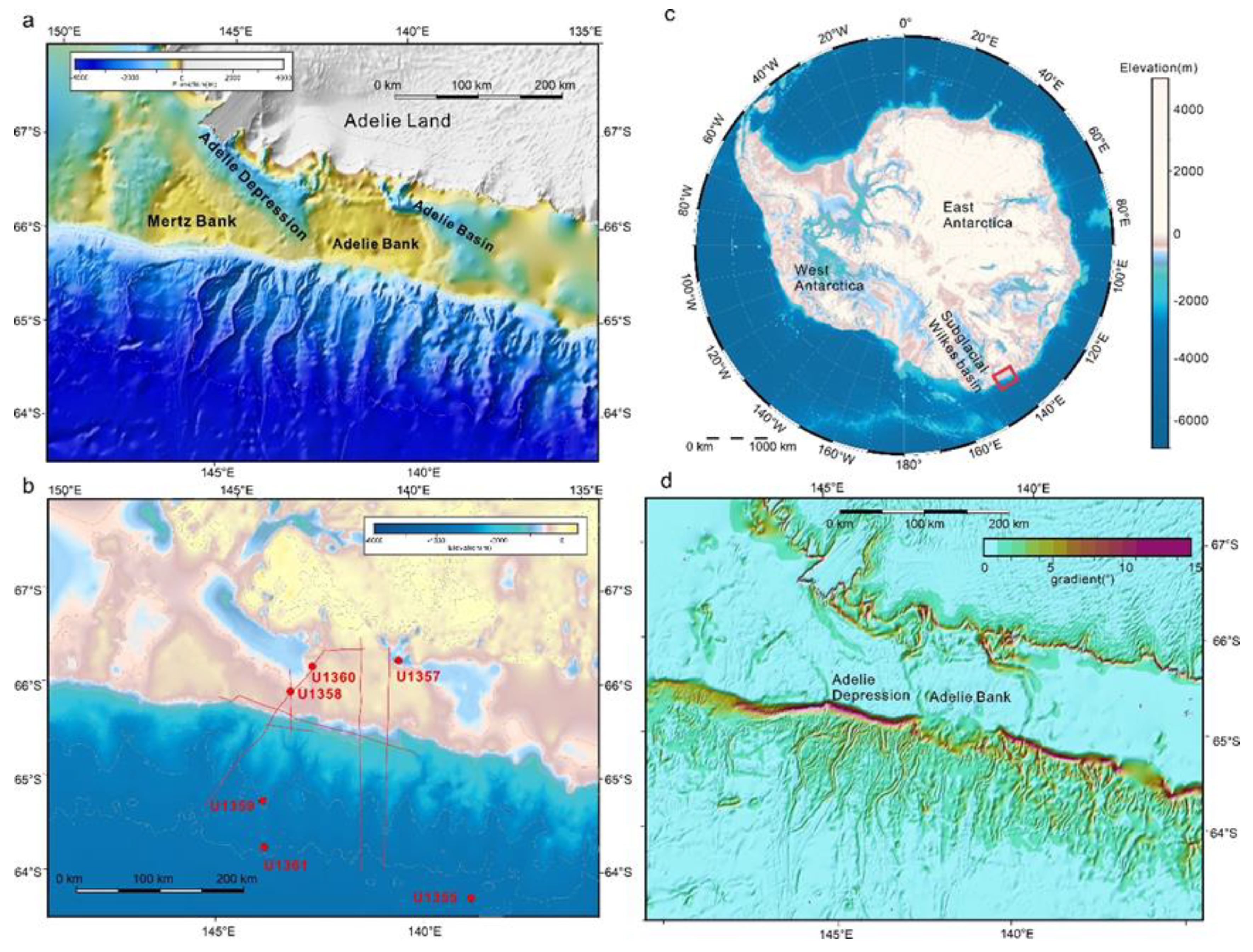
Figure 2.
(a) average canyon-channel system length, (b) sinuosity index, (c) W/D ratio, (d) depth, (e) width and (e) canyon-channel type distribution on the Adélie Depression region and Adélie Bank region.
Figure 2.
(a) average canyon-channel system length, (b) sinuosity index, (c) W/D ratio, (d) depth, (e) width and (e) canyon-channel type distribution on the Adélie Depression region and Adélie Bank region.
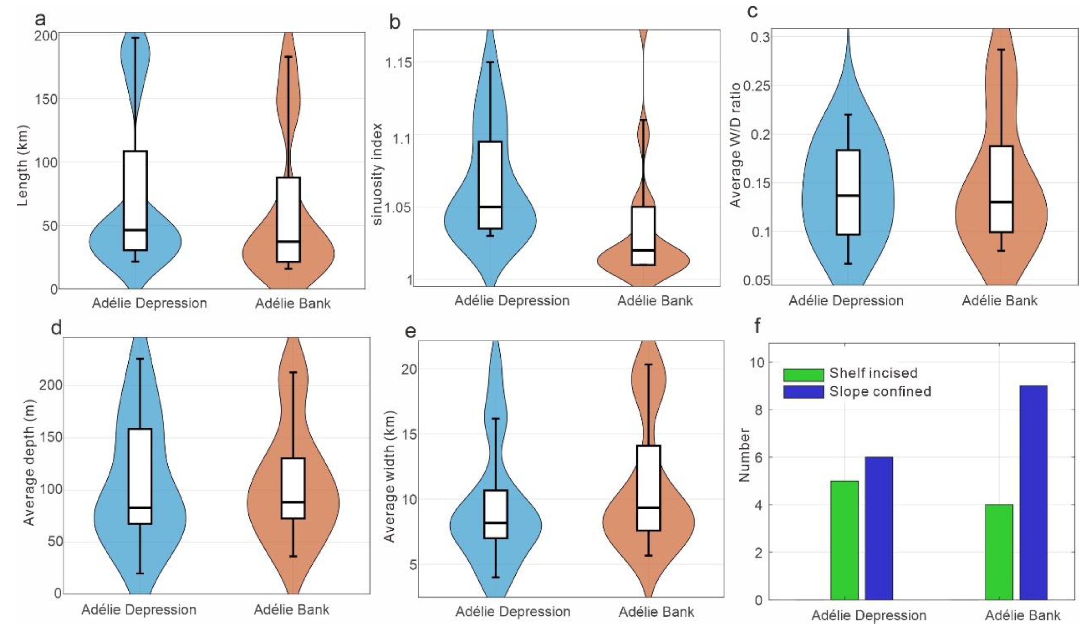
Figure 3.
The distribution of canyon-channel systems at the front of Adélie Depression, (b) canyon-channel systems map on the bathymetry map and (c) slope map of Adélie Depression area, (a, d, e, f, g, h) the cross-section profiles of the different sections of canyon-channel system.
Figure 3.
The distribution of canyon-channel systems at the front of Adélie Depression, (b) canyon-channel systems map on the bathymetry map and (c) slope map of Adélie Depression area, (a, d, e, f, g, h) the cross-section profiles of the different sections of canyon-channel system.
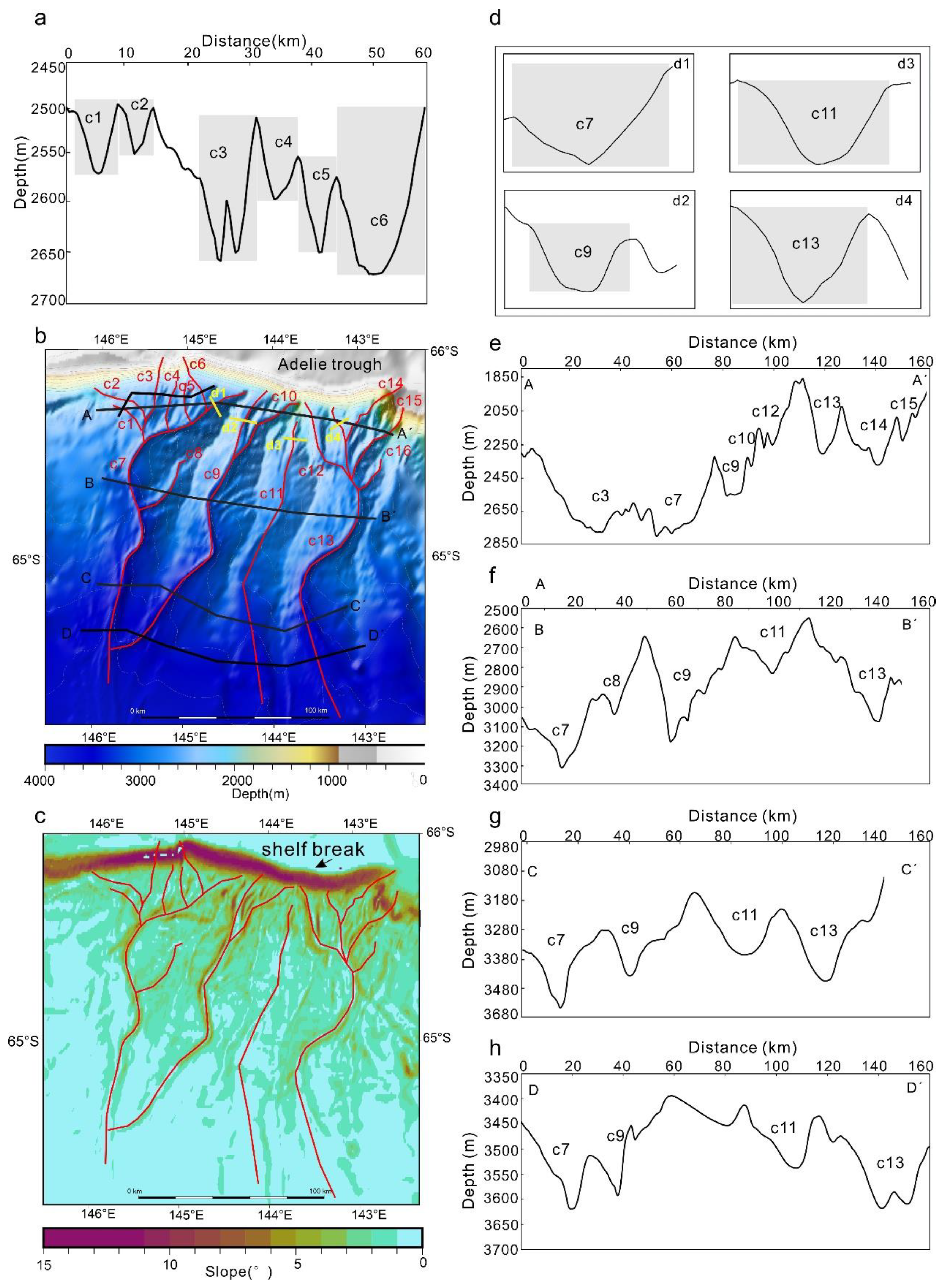
Figure 4.
The distribution of canyon-channel systems on the Adélie Bank margin, (b) canyon-channel systems map on the bathymetry map and (c) slope map of Adélie Bank area, (a, d, e, f) the cross-section profiles of the different sections of canyon-channel systems.
Figure 4.
The distribution of canyon-channel systems on the Adélie Bank margin, (b) canyon-channel systems map on the bathymetry map and (c) slope map of Adélie Bank area, (a, d, e, f) the cross-section profiles of the different sections of canyon-channel systems.
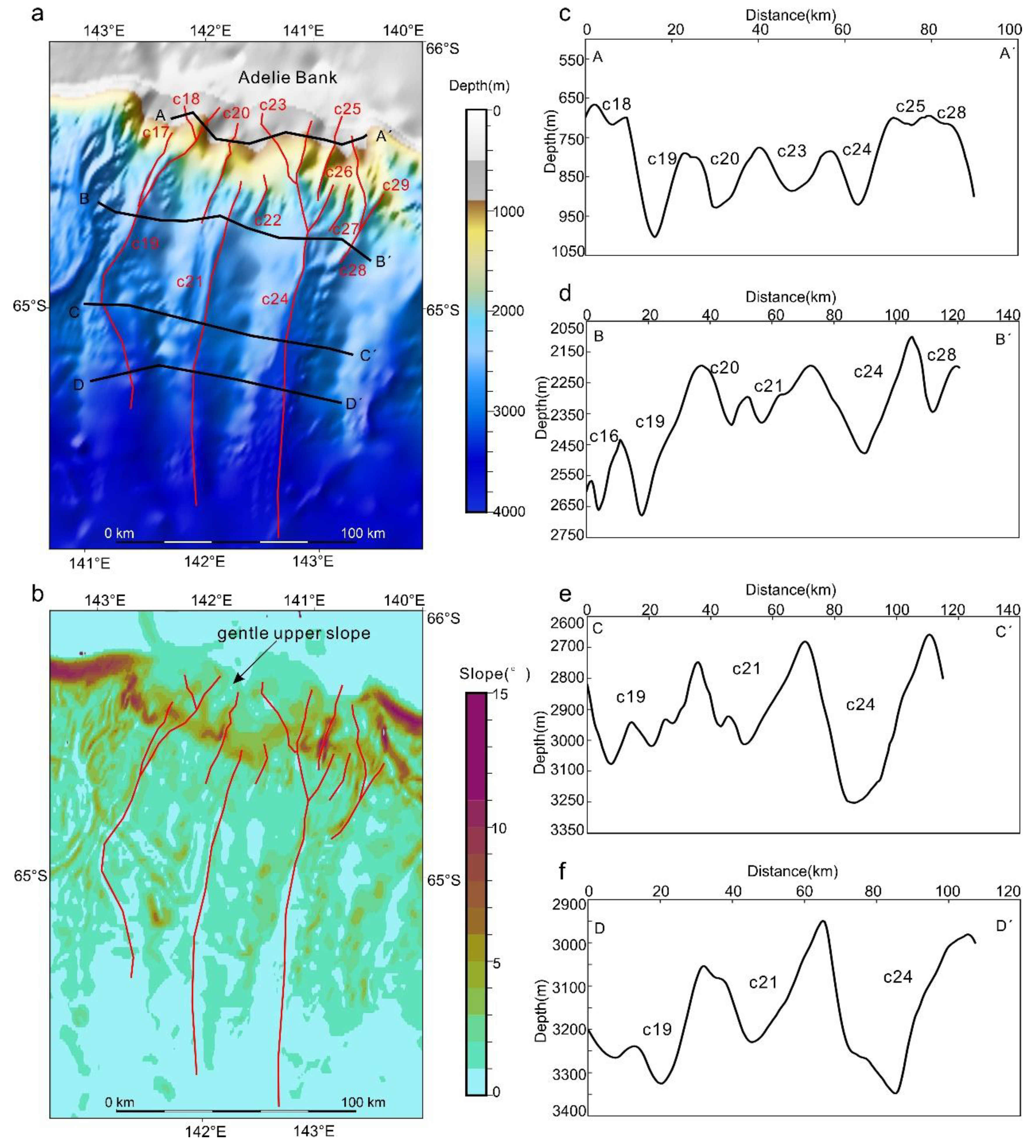
Figure 5.
Cross-section along continental margin of Adélie Depression and Adélie Bank region. (a) the location of cross-section profile, (b, c) the depth of these profiles extracted from bathymetry map, (d) The cross section across the outer continental shelf and (e, f) slope profile along the continental slope extracted from slope map.
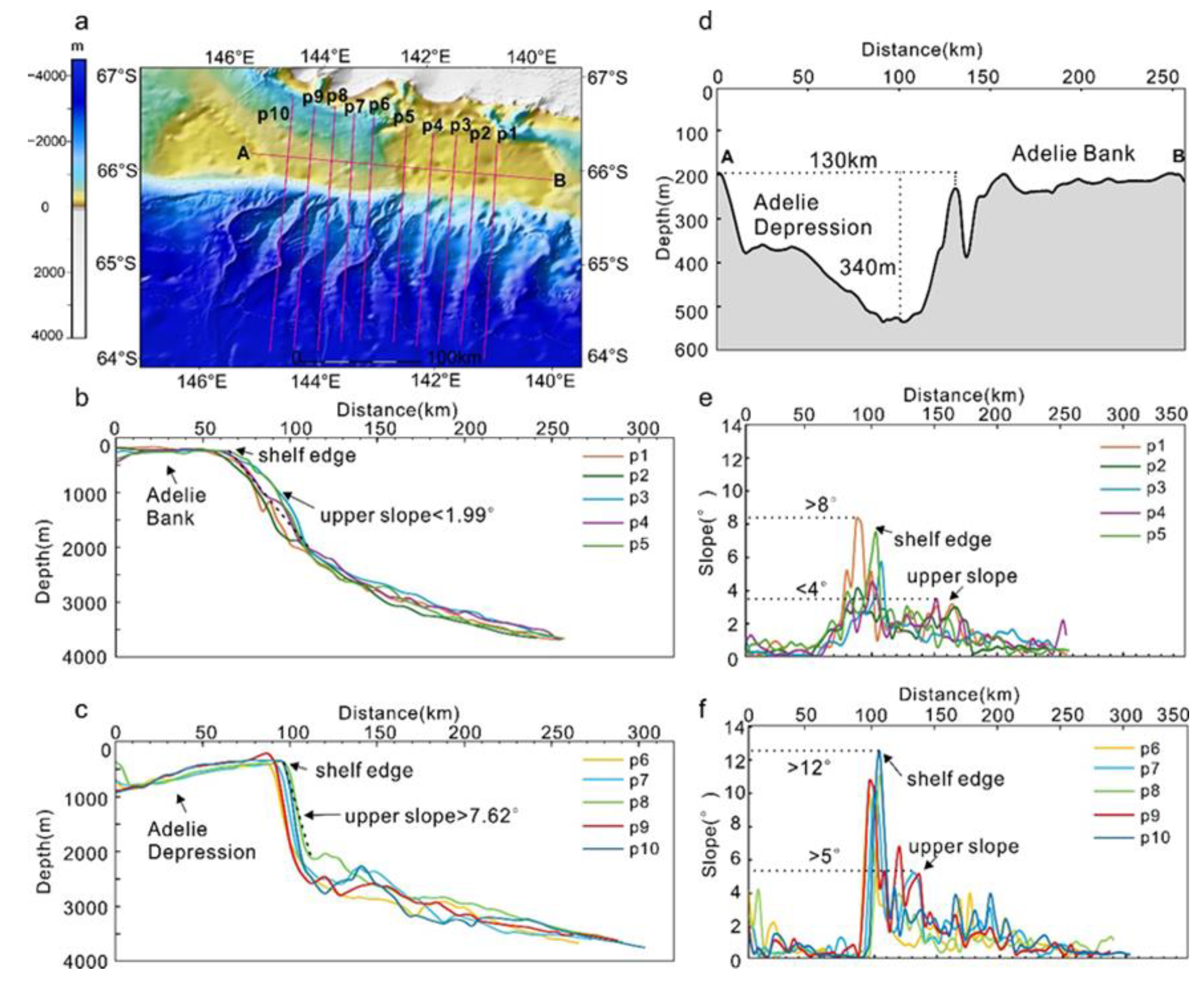
Figure 8.
Conceptual model of controlling factors on submarine canyon-channel system morphology along the Adélie Land margin, East Antarctica. Adélie Depression: extensive dendritic canyon-channel systems, Adélie Bank: separated single-branch canyon-channel system. (a-b) Shelf-Slope control on canyon-channel development, (c, d) Ice-sheet dynamics and sediment supply on the evolution of submarine canyon-channel systems.
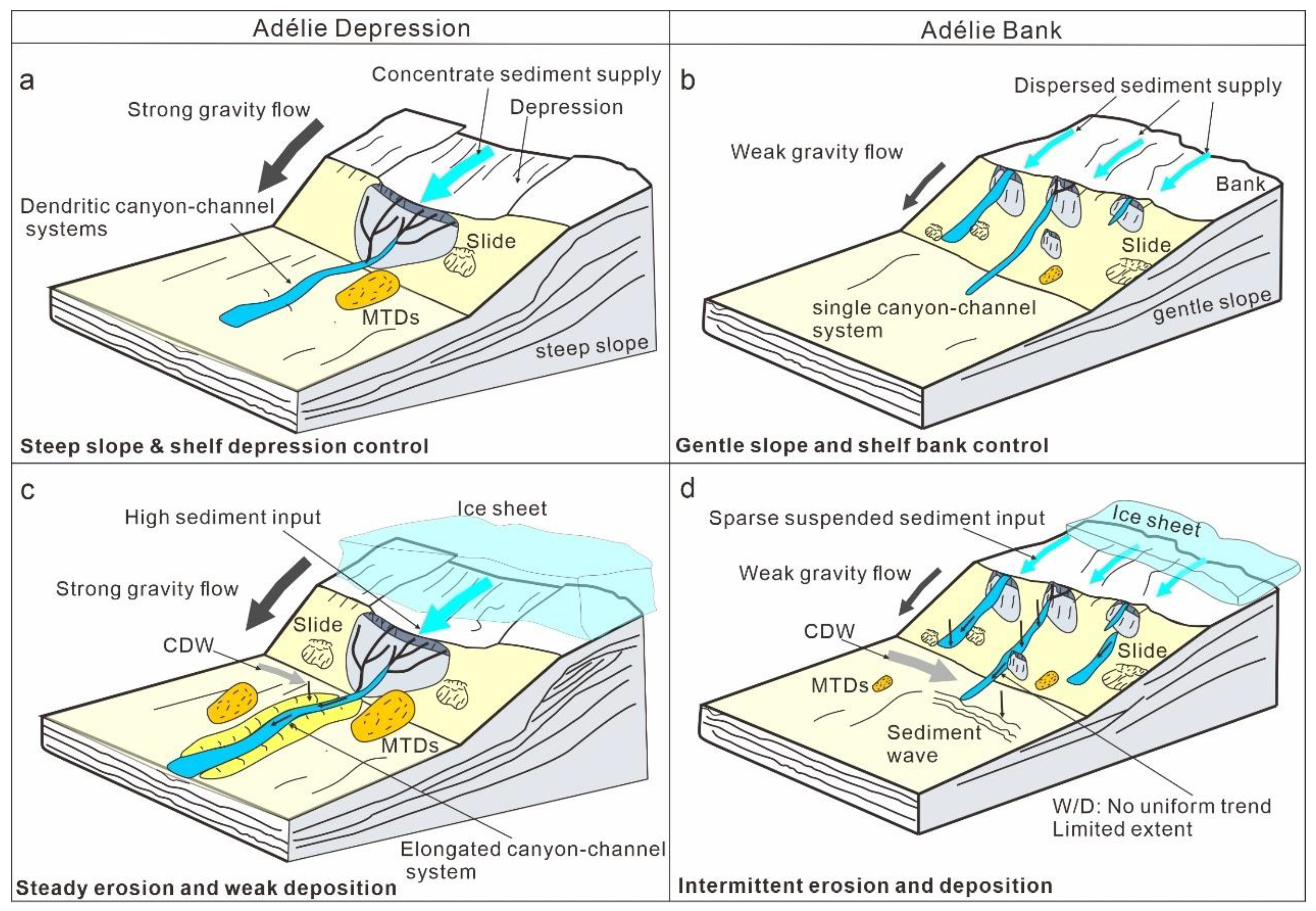

Table 1.
Param of canyon-channel systems at the front of Adélie Depression and Adélie Bank
| Area | Name | Type | Length | Straight | Sinuosity | Width (km) | Depth(m) | W/D ratio | ||||||
|---|---|---|---|---|---|---|---|---|---|---|---|---|---|---|
| (km) | Length | index | ||||||||||||
| (km) | Head | middle | lower | Head | middle | lower | Head | middle | lower | |||||
| Adélie Depression | C1 | slope confine | 21.5 | 20.5 | 1.05 | 7.0 | 9.0 | 4.0 | 37 | 135 | 89 | 0.19 | 0.07 | 0.04 |
| C2 | slope confine | 35.7 | 32.9 | 1.09 | 14.0 | 6.0 | 5.0 | 192 | 19 | 25 | 0.07 | 0.32 | 0.20 | |
| C3 | shelf-incised | 48.6 | 47.4 | 1.03 | 6.0 | 6.0 | 4.0 | 68 | 40 | 89 | 0.09 | 0.15 | 0.04 | |
| C4 | slope confine | 28.3 | 27.3 | 1.04 | 4.0 | 5.0 | 3.0 | 23 | 23 | 14 | 0.17 | 0.22 | 0.21 | |
| C5 | slope confine | 22.8 | 22.1 | 1.03 | 4.0 | 4.0 | 4.0 | 34 | 62 | 18 | 0.12 | 0.06 | 0.22 | |
| C6 | shelf-incised | 32.5 | 31.6 | 1.03 | 8.0 | 8.0 | 6.0 | 345 | 108 | 32 | 0.02 | 0.07 | 0.19 | |
| C7 | slope confine | 198 | 172.1 | 1.15 | 15.0 | 18.0 | 16.0 | 367 | 253 | 58 | 0.04 | 0.07 | 0.28 | |
| C8 | slope confine | 39 | 35.6 | 1.10 | 7.0 | 8.0 | 9.0 | 48 | 140 | 20 | 0.15 | 0.06 | 0.45 | |
| C9 | shelf-incised | 181 | 170.4 | 1.06 | 8.0 | 16.0 | 9.0 | 22 | 205 | 65 | 0.36 | 0.08 | 0.14 | |
| C10 | slope confine | 48.6 | 47.1 | 1.03 | 9.0 | 8.0 | 8.0 | 68 | 105 | 293 | 0.13 | 0.08 | 0.03 | |
| C11 | slope confine | 157 | 151.4 | 1.04 | 10.0 | 25.0 | 13.0 | 137 | 180 | 61 | 0.07 | 0.14 | 0.21 | |
| C12 | shelf-incised | 60 | 53.7 | 1.12 | 9.0 | 8.0 | 10.0 | 140 | 265 | 88 | 0.06 | 0.03 | 0.11 | |
| C13 | slope confine | 185 | 165.0 | 1.12 | 8.0 | 30.0 | 22.0 | 112 | 427 | 58 | 0.07 | 0.07 | 0.38 | |
| C14 | shelf-incised | 44 | 42.0 | 1.05 | 12.0 | 5.0 | 6.0 | 35 | 57 | 80 | 0.34 | 0.09 | 0.08 | |
| C15 | slope confine | 50 | 48.0 | 1.04 | 10.0 | 9.0 | 12.0 | 49 | 81 | 81 | 0.20 | 0.11 | 0.15 | |
| C16 | slope confine | 22 | 20.6 | 1.07 | 9.0 | 7.0 | 8.0 | 65 | 111 | 56 | 0.14 | 0.06 | 0.14 | |
| mean | / | 73.4± 68.7 | 68.0 ± 63.1 | 1.07± 0.05 | 8.8± 3.8 | 109± 105.2 | 0.14± 0.09 | |||||||
| Adélie Bank |
C17 | slope confine | 34.4 | 34.1 | 1.01 | 8.0 | 5.0 | 9.0 | 88 | 91 | 86 | 0.09 | 0.05 | 0.10 |
| C18 | slope confine | 15.8 | 15.5 | 1.02 | 6.0 | 5.0 | 12.0 | 23 | 17 | 69 | 0.26 | 0.29 | 0.17 | |
| C19 | shelf-incised | 153 | 138.6 | 1.10 | 17.0 | 8.0 | 30.0 | 169 | 170 | 276 | 0.10 | 0.05 | 0.11 | |
| C20 | slope confine | 48 | 46.9 | 1.02 | 14.0 | 6.0 | 6.0 | 120 | 93 | 36 | 0.12 | 0.06 | 0.17 | |
| C21 | slope confine | 138 | 137.2 | 1.01 | 11.0 | 26.0 | 24.0 | 69 | 141 | 46 | 0.16 | 0.18 | 0.52 | |
| C22 | slope confine | 18 | 17.2 | 1.05 | 4.0 | 8.0 | 7.0 | 20 | 94 | 75 | 0.20 | 0.09 | 0.09 | |
| C23 | shelf-incised | 40.4 | 38.5 | 1.05 | 13.0 | 16.0 | 9.0 | 189 | 61 | 86 | 0.07 | 0.26 | 0.10 | |
| C24 | shelf-incised | 183 | 180.3 | 1.01 | 10.0 | 29.0 | 18.0 | 133 | 394 | 112 | 0.08 | 0.07 | 0.16 | |
| C25 | shelf-incised | 37.2 | 36.9 | 1.01 | 8.0 | 14.0 | 7.0 | 12 | 264 | 171 | 0.67 | 0.05 | 0.04 | |
| C26 | slope confine | 22.6 | 22.4 | 1.01 | 4.0 | 8.0 | 5.0 | 31 | 58 | 34 | 0.13 | 0.14 | 0.15 | |
| C27 | slope confine | 22 | 21.6 | 1.02 | 7.0 | 9.0 | 12.0 | 84 | 110 | 34 | 0.08 | 0.08 | 0.35 | |
| C28 | slope confine | 71 | 60.2 | 1.18 | 8.0 | 12.0 | 8.0 | 34 | 105 | 207 | 0.24 | 0.11 | 0.04 | |
| C29 | slope confine | 19 | 18.9 | 1.01 | 8.0 | 8.0 | 8.0 | 175 | 57 | 141 | 0.05 | 0.14 | 0.06 | |
| mean | / | 62.1± 63.4 | 59.2± 60.0 | 1.04± 0.05 | 11± 6.4 | 106.7± 78.2 | 0.15± 0.13 | |||||||
Disclaimer/Publisher’s Note: The statements, opinions and data contained in all publications are solely those of the individual author(s) and contributor(s) and not of MDPI and/or the editor(s). MDPI and/or the editor(s) disclaim responsibility for any injury to people or property resulting from any ideas, methods, instructions or products referred to in the content. |
© 2026 by the authors. Licensee MDPI, Basel, Switzerland. This article is an open access article distributed under the terms and conditions of the Creative Commons Attribution (CC BY) license (http://creativecommons.org/licenses/by/4.0/).
Copyright: This open access article is published under a Creative Commons CC BY 4.0 license, which permit the free download, distribution, and reuse, provided that the author and preprint are cited in any reuse.


