Submitted:
12 January 2026
Posted:
14 January 2026
You are already at the latest version
Abstract
Rural architectural systems in the Mediterranean reflect a long-term entanglement between human agency, material conditions, and environmental constraints. This study uses this framework to explore architectural continuity in settlements near ancient Phoenix in Türkiye. It aims to understand how rural building practices like stone masonry, traditional carpentry, and spolia reuse have persisted from antiquity. The methodology combines UAV photogrammetry, GIS analysis, and oral histories to reveal spatial patterns and craft traditions across generations. Findings show structures are transmitted through technical knowledge, with stone and timber co evolving with local livelihoods. The Aegean's technical traditions share heritage with the Dodecanese islands of Symi and Tilos, supported by fieldwork and literature comparing masonry and craft techniques. The work emphasizes the need for conservation strategies that connect digital documentation with community experience to preserve this cross-border cultural landscape amid environmental threats and declining craftsmanship.
Keywords:
architectural continuity
; craftsmanship
; masonry
; vernacular architecture
; entanglement
; Mediterranean architecture
1. Introduction
Rural architectural systems in the Mediterranean are linked to agricultural practices and ecological settings. Historically, patterns of production shaped not only economies but also settlement structures, spatial organisation, and construction techniques. As shown in the studies [1], from the Iron Age through the Medieval period, land-use systems determined building form, materials, and regional connectivity, thereby marking architecture as both a product and an expression of environmental interaction.
Across the study’s landscape, vernacular traditions consistently feature materials like stone, timber, clay, and reused architectural fragments (spolia). These elements reflect resource adaptation, besides the continuity of cultural knowledge passed through generations. On the Bozburun Peninsula (Figure 1), the spatial evolution of Taşlıca and Fenaket exemplifies these dynamics. Their construction methods and material choices align with broader Aegean patterns of architectural continuity and ecological adaptation, shaped by geography, topography, and microclimate [2,3].
Such rural environments are increasingly recognised as cultural landscapes which are defined as living systems where natural and human histories overlapping. As emphasised by UNESCO [4], and ICOMOS [5,6], cultural landscapes are not fixed monuments but evolving sites of memory, craftsmanship, and local agency. Policy frameworks such as the European Landscape Convention [7], and the ICOMOS-IFLA Principles [8], further advocate integrating community voices and valuing traditional skills in conservation planning [9,10].
This study investigates the historical continuity of vernacular construction systems (masonry, roof carpentry, and the reuse of spolia) in the rural settlements of Taşlıca, Büğüş and Fenaket, both of which are layered around the ancient city of Phoenix. These villages, shaped by environmental constraints and historical memory, offer a perspective on how building traditions persist, adapt, and connect with neighbouring Aegean settlements such as Simi and Tilos.
The theoretical framework draws on the principle of entanglement, as developed by Hodder [11], and Turner [12], to interpret how architecture and landscape co-evolve. In this view, the rural character of Taşlıca, Fenaket and Büğüş is not only a historical artifact but a living archive of knowledge, embedded in stone, timber, and spatial practice.
However, these transferred techniques face rapidly increasing threats such as population decline and drought, mass tourism, and unregulated construction. These pressures not only threaten the built heritage but also cause the disappearance of the cultural background that sustains it. Understanding this fragility is crucial for developing sustainable and community-focused conservation strategies [13].
The main objective of this study is encapsulated in the research question: How do construction techniques mediate landscape continuity in Mediterranean cultural landscapes (Figure 2)? By analysing construction techniques, material continuity, and the reuse of stone, it attempts to define the relationship between physical tectonic traditions and ecological environments. Furthermore, through comparisons across the Aegean Region, the research aims to support broader frameworks for protecting rural heritage through locally-based, participatory approaches.
Vernacular architecture is increasingly recognised as cultural heritage shaped by the interplay of human behaviour, ecological adaptation, and material tradition. According to the perspectives, domestic architecture arises not solely from technical constraints but from social values, ritual norms, and environmental relationships. In this view, In this view, buildings are cultural phenomena shaped by climate and social organization [14,15]. Studies of historical centers in the Mediterranean demonstrate that the quality of residential heritage is inextricably linked to the preservation of these traditional spatial logics [16].
This transformation has been expanded upon by academics who reconceptualise local architecture as a living system of knowledge transfer [17,18]. Their work emphasises that these traditions encode concrete logic, collective identity, and social practices, sustaining their function and meaning across generations. Vernacular architecture is a field of practice where local knowledge is actively sustained and reshaped through craft practices and ecological interventions.
In the Mediterranean context, this cultural-environmental dialogue is especially evident. Studies of Crete, the Cyclades, and southwestern Anatolia show that rural communities share an "economy of means" approach to building dwellings with locally available materials using techniques of reuse, repair, and environmental adaptation [19]. These strategies demonstrate that vernacular systems are resource-efficient and resilient, based on a deep understanding of climate, topography, and seasonal cycles.
Despite this resilience, vernacular architecture now faces significant threats. Vellinga [20] and Mileto et al. [21] contend that depopulation, abandonment, and incompatible modernisation are undermining the intergenerational transmission of craft knowledge essential for vernacular continuity. Consequently, the documentation, reinterpretation, and community integration of these practices have become increasingly urgent in the Bozburun Peninsula, where vernacular forms persist yet remain vulnerable to loss.
1.1. Material and Construction Traditions: Stonework, Roof Systems, and Earthen Techniques
The practices in the construction materials lie at the core of Mediterranean vernacular continuity, where building systems reflect not only environmental adaptation but also embedded cultural values. An essential element of this tradition is the reuse of architectural elements or spolia that serve both practical and symbolic purposes. Brilliant and Kinney's work Reuse Value [22] reframes spolia not only as remains of the past but as active actors in the creation of meaning. Following Esch's fundamental concept of “a form of new life” [23], reuse is reimagined as renewal rather than decay. In Taşlıca, Büğüş and Fenaket, the integration of carved stones and column drums into the new structure exemplifies this principle. Here, spolia is not simply material recycling, but also a cultural orientation towards time, memory, and identity (Figure 3).
Additionally, the use of wooden element systems complements the stone tradition and incorporates a similarly adaptable architectural principle. Research conducted in Rhodes, Simi, and Bozburun reveals the consistent use of pine and cypress wood in the beams, columns, and joists of the structures [24,25]. These wooden structures combine structural efficiency with material availability in response to environmental conditions such as seismic activity and seasonal loads. The repetition of these structures throughout the region reflects the transmission of building knowledge through shared craftsmanship and families [26].
Recent studies have highlighted earth techniques as a vital yet often disregarded component of the Mediterranean local heritage. Mousourakis et al. [27] documented adobe, wattle-and-daub, and earth-filled systems in rural settlements in Greece, observing their continuity from antiquity to the modern era. These methods demonstrate a complementary material system in which stone, wood, and earth function within a unified architectural logic of repair, flexibility, and cyclical renewal [26,27,28]. The continuity here is based on monumentality and permanence, as well as on maintenance, care, and community participation. These overlapping construction traditions support a holistic view of local resilience.
1.2. Cultural Landscape, Entanglement, and Heritage as Process
The concept of the cultural landscape provides a critical interpretive framework for connecting architecture, environment, and social practice. According to UNESCO [4] and the European Landscape Convention [9], landscapes are defined as dynamic systems continuously shaped by the interaction of nature, culture, and human activity. From this perspective, characterise landscapes as palimpsests, or multi-layered terrains where historical traces coexist with ongoing practices. This perspective situates architectural heritage within a dynamic continuum, rather than conceptualising it as a static remnant of the past [29,30].
Building on this foundation, entanglement theory [11,12] further refines the analysis by highlighting the shared relationships among people, nature, and materials. In this framework, built environments are not merely passive outcomes of human intent; rather, they act as active participants in shaping cultural memory and behaviour. DeSilvey's [31] concept of "curated decay" offers a valuable framework for understanding heritage as a process of transformation, representing an ongoing negotiation between material persistence and cultural reinterpretation. From this perspective, change is not in opposition to conservation; rather, it is a natural aspect of conservation practices [3].
This paradigm shift towards traditional heritage has brought vernacular conservation to the forefront of recent discussions. Harney [32] posits that the preservation of vernacular architecture is inherently linked to the maintenance of the social and ecological practices that imbue it with significance. This encompasses craft knowledge, resource cycles, and community agency, situating conservation within living systems of care rather than static preservation. These frameworks complement entanglement theory by suggesting that heritage endures not through immobilisation but through ongoing enactment, a phenomenon clearly observed in the construction material practices and continuity present in Taşlıca and Fenaket.
This approach is supported by empirical evidence. Castrorao Barba et al. [33] show that resilience in Mediterranean cultural landscapes is rooted in adaptive reorganisation rather than permanence, using GIS-based settlement analysis in Sicily's Sicani Mountains. Their concept of "continuity through change" closely parallels the construction logics observed in Taşlıca and Fenaket, where spolia, hybrid techniques, and repair practices reflect a long-standing tradition of adapting materials to social and ecological changes.
However, these living systems are vulnerable. Gómez Martínez et al. [34] emphasise how the loss of rural residents affects the passing of traditional skills from one generation to the next, thereby jeopardising the cultural practices and the knowledge they represent. As communities decrease in population or age, previously resilient architectural systems become fragile and fall into disrepair. These dynamics strongly resonate with the current conditions in Taşlıca and Fenaket, where demographic decline endangers the cultural transmission embedded in dry-stone techniques and timber carpentry.
Recognising continuity as a dynamic process within construction techniques emphasises the necessity of heritage strategies that prioritise community vitality alongside material preservation. In this context, cultural landscapes must be understood as ecologies of knowledge where architecture, the environment, and social life remain mutually entangled, not as static artifacts.
1.3. The Historical Evolution of Phoenix: Built-Environment and Social Values
The rural settlement of Phoenix, located on the Bozburun Peninsula (Figure 4), offers a distinctive case study of architectural and socio-economic transformation. These transformations have been shaped by successive political regimes and environmental adaptation. From the Late Classical period through the Republican era, the region underwent significant transformations in governance, marked by the transition from Rhodian hegemony to Ottoman administration and the subsequent development of modern nation-building. These historical shifts left enduring imprints on the region's built environment and settlement patterns [35].
In the Late Classical and Early Hellenistic periods, Phoenix was a compact fortified settlement organised around an acropolis, as described by Strabo [36] and Pliny [37]. Archaeological remains, including inscriptions related to a temple of Dionysos [38] (Figure 4).
The Hellenistic reorganisation under Rhodian rule introduced a deme-based administrative system, thereby restructuring local identity through integration into broader Aegean political networks [38,39]. This transition coincided with three major developments: agricultural intensification, terrace construction, and demographic expansion [41]. These changes transformed Phoenix from a compact settlement into a dispersed rural landscape adapted to specialised production, notably viticulture [42].
During the periods of Roman and Byzantine governance, while the broader coastal region of Caria experienced decline [43], the city of Phoenix maintained its strategic significance. As evidenced by the transformation of temples into churches and the repurposing of necropolises for residential use in rural settings [44] (Figure 5), a clear demonstration emerges of spatial and material continuity. This phenomenon, characterised by the convergence of sacred and domestic architectures, signifies an inaugural manifestation of spolia-based adaptation strategies.
The Turkish and Ottoman periods introduced novel demographic and spatial logics. The Menteşe Beyliği established Tarahya (formerly Phoenix) as a semi-nomadic hub [45], where ancient ruins provided materials for emerging village structures. The Ottoman records document a structured rural economy tied to imperial land allocation systems, while the area's designation as a kaza and unit of agricultural measurement reflects its administrative centrality.
The Republican era was marked by significant demographic shifts, particularly with the 1923 Population Exchange [46]. The mass population exchange of Greeks (Rum) populations resulted in a diminution of the region's skilled labour base. However, oral histories indicate that Greek craftsmanship, particularly from the nearby island of Symi (known locally as Sömbeki), was maintained and incorporated by Turkish builders. This knowledge transfer played a crucial role in preserving the cultural heritage of vernacular stonework traditions, particularly in the context of demographic shifts [47]. The consolidation of the settlement into Taşlıca in 1968 formalised the spatial transition from dispersed to nucleated settlements.
In essence, Phoenix, also referred to as Tarahya, Fenaket, and Taşlıca, exemplifies the manner in which historical transformations in power, population, and production have given rise to a multifaceted architectural and cultural landscape (Figure 6). Its continuity is not rooted in architectural permanence; rather, it is sustained by the adaptive reuse of space, material, and memory across political regimes. This finding aligns with the broader argument posited in the studay, which asserts that cultural landscapes endure through negotiated entanglements between environment, governance, and vernacular knowledge.
The scholarly investigation of Phoenix and the Bozburun Peninsula has evolved from early exploratory travel writing into a focused, interdisciplinary research tradition. Initial references to ancient settlements such as Phoenix can be traced back to the fragmented observations of nineteenth-century travellers, including Leake [48], Spratt and Forbes [49] and Bent [50]. The epigraphic notes of the latter two laid the preliminary foundation for locating and contextualising the site. While their accounts were impressionistic, they nevertheless initiated avenues for systematic study within the scholarly domain.
A more coherent research framework emerged with Fraser and Bean's The Rhodian Peraea and Islands [51], which synthesised epigraphic and topographic data across the region. This seminal publication formally positioned Phoenix within the broader political geography of the Rhodian Peraea, thereby establishing its administrative significance and settlement logic. The work of these scholars remains a cornerstone in understanding regional integration under Rhodian control.
By the late twentieth century, archaeological research had expanded both in scope and precision. Systematic surveys conducted by Held (2000-2009) [39,40,41,42,43,44,45,46,47,48,49,50,51,52,53] at proximate locations such as Bybassos and Loryma elucidated defensive systems and rural spatial organisation, thereby offering comparative insights that facilitate comprehension of Phoenix's own layout. The Hellenistic reorganization under Rhodian rule structured local identity through integration into broader Aegean political and epigraphical networks [54,55] which have deepened the analysis of civic identity through inscriptions, thus contributing to a more nuanced reading of Phoenix's urban and social fabric.
Meanwhile, site-specific studies across the peninsula (e.g., Gürbüzer at Amos, Kuban and Saner at Kıran Gölü, and work at Kastabos) have enriched our knowledge of the region's archaeological diversity, highlighting cross-site continuities in construction and settlement form. It is noteworthy that Özberk's [56] master's thesis represented a methodological shift by documenting the vernacular architecture of seasonal settlements such as Fenaket, thereby bridging the disciplines of archaeology and rural architectural heritage.
During the 2010s, the application of Geographic Information Systems (GIS) by Oğuz-Kırca [57] added a contemporary dimension to regional interpretation. The spatial reconstructions of Phoenix's urban layout and territorial extents offered hypothetical models of demographic structure and land use, enabling evidence-based theorisation of landscape evolution. The integration of field data from PAP with historical and spatial analysis contributes a new interpretive layer to the study of Phoenix, centring the cultural landscape not only as an object of excavation, but also as a living archive of building knowledge, material reuse, and intergenerational adaptation.
2. Materials and Methods
The present study investigates the evolving relationship between building form, environment, and cultural practice in the Phoenix cultural landscape. The research design is interdisciplinary and multi-scalar, integrating tools from architecture, archaeology, and digital humanities to trace the continuity of vernacular construction. Each discipline contributes distinct insights: Architectural analysis provides a comprehensive understanding of structural evolution; archaeology unveils historical contexts and layers; and digital humanities incorporate advanced technologies like UAV photogrammetry and GIS mapping, which reveal spatial patterns invisible to other methods, such as oral testimony. This hybrid approach ensures methodological rigor and a holistic perspective on the cultural landscape.
The research is grounded in the Entanglement Framework [11,12] and conceptualises Fenaket–Taşlıca as a living cultural landscape, i.e., a space shaped by reciprocal interactions among human agency, ecological conditions, and material persistence. This theoretical foundation informed the integration of archival material, field documentation, and digital technologies to assess the continuity of craftsmanship over time [58].
The present study combines traditional architectural survey techniques with contemporary tools such as UAV photogrammetry, GIS mapping, and 3D modelling. This hybrid approach enabled both quantitative spatial analysis and qualitative interpretation of local construction systems. Of particular significance is the methodological model it provides, which supports community-based heritage documentation grounded in lived experience.
The present study benefits from reports and archives from the Phoenix Archaeological Project (PAP). This approach reflects a complementary utilisation of existing resources, with PAP materials serving as contextual references rather than as primary data. The methodological stance adopted in this study aligns with Harney's [32] conceptualisation of heritage as a process of care, emphasising continuity through practice rather than preservation alone.
2.1. Data Collection
Oral History and Local Knowledge
Oral history constituted a central component of the research, aimed at documenting the transmission of traditional building knowledge and interpreting architecture as a living cultural process. Ten semi-structured interviews were conducted with residents of Fenaket and Taşlıca, aged 29 to 65. The participants were selected based on their expertise in construction, agriculture, and domestic spatial practice, comprising five males and five females. Participants were identified and recruited using snowball sampling, initiated by recommendations from community leaders in the villages. This approach was chosen to ensure the inclusion of individuals with significant traditional knowledge and involvement in local practices, thereby enhancing the reliability and representativeness of the oral history data.
One illustrative question posed to female participants, particularly focusing on repair rituals, was: 'Can you describe a specific repair ritual that is important in maintaining your home, and how this knowledge was passed down to you?' This question further highlighted the depth of gendered knowledge and showcased how repair practices are interlinked with cultural identity and memory.
The following topics will be covered in this section:
The identification of construction techniques and the acquisition of knowledge regarding materials, including quarrying sites, dry-stone techniques, lime-burning, timber treatment and roof design.
Spatial and Social Transformations: the phenomenon of seasonal migration, the establishment of production zones, and the relocation of settlements due to the influence of tourism and improved access to water.
The focus of this study is on the concept of craftsmanship and its intergenerational transmission, with specific attention paid to the roles of master and apprentice, communal labour, and gendered practices of repair. The transcribed interviews were then subjected to thematic coding, with motifs such as "the language of stone", "living houses", and "from flat roofs to pitched tiles" being identified. These oral narratives provided a cultural context for physical transformations, revealing that spolia reuse, natural wood preservation, and lime-clay mortars persist through non-written, embodied knowledge.
It is important to note that these testimonies highlighted the significant emotional and mnemonic value of abandoned structures. Some families continue to occupy ancestral houses seasonally, perceiving them as repositories of memory rather than ruins. This perspective is consistent with the entanglement theory's emphasis on material–human–memory relationships, thereby supporting the interpretation of architecture as an active archive.
Architectural Survey
The architectural survey was conceived to evaluate the morphological evolution and the continuity of building techniques across temporal and settlement layers. The research focused on residential architecture in Lower and Upper Fenaket, Büğüş, and Taşlıca. A three-phase documentation strategy was employed:
- Preliminary assessment: general condition and accessibility.
- Mapping and Delimitation: GPS marking of structures, settlement boundary definition.
- The collection of architectural data encompasses the documentation of photographs, sketches, typological inventories, and the recording of construction details.
This methodological approach facilitated typological classification, identification of spatial hierarchies, and mapping of wall systems. These findings contributed to the development of digital reconstructions and facilitated cross-temporal comparisons.
Digital Documentation and Analysis
To ensure the highest possible spatial accuracy, aerial photogrammetry was carried out using DJI Mavic 3 and Phantom 4 Pro drones at a flight height of 50–70 metres. The ground control points were georeferenced using GPS. The images were processed in Agisoft Metashape to produce dense point clouds and surface meshes, integrating both aerial and terrestrial datasets (Figure 7 and Figure 8).The outputs were subsequently utilised to facilitate the generation of the following:
- 2D architectural plans (AutoCAD)
- Wall section analyses (Photoshop)
- Restitution modelling (SketchUp)
Subsequently, all data were imported into a Geographic Information System (GIS) environment, thereby enabling the linkage of typologies to topography, orientation, and elevation. This workflow provided a technical basis for damage mapping, material analysis, and conservation planning.
2.2. Data Analysis
The scope and logic of architectural continuity were interpreted through the integration of data analysis, spatial documentation and oral history. The application of Geographic Information System (GIS)-based visualisation techniques has yielded insights into the correlations between settlement layout, environmental conditions, and building form. In addition, three-dimensional (3D) models have been employed to highlight patterns of spolia reuse, roof transformations, and wall repairs.
A comparative analysis between Fenaket, Büğüş and Taşlıca demonstrated that continuity is not static reproduction but rather a pattern of adaptation, shaped by local knowledge and ecological responsiveness. Within the entanglement framework, built forms were interpreted as co-evolved outcomes of cultural memory, ecological constraint, and social agency. However, the study has certain limitations that must be acknowledged. The sample size of the oral interviews was relatively small, and the research was subject to seasonal constraints that may have limited the scope of fieldwork observations. Additionally, there are potential data gaps, particularly in historical records, which may impact the completeness of the findings. Nonetheless, this integrated approach has two principal benefits. Firstly, it reveals the resilience of vernacular systems. Secondly, it offers a replicable heritage method. The study demonstrates that sustainability and identity in cultural landscapes are contingent on documenting living knowledge rather than solely on architectural form (Table 1).
3. Results and Discussion
This section presents and interprets the findings derived from field documentation, oral history interviews, and digital analyses conducted in Fenaket, Büğüş, and Taşlıca. The objective of this study is to elucidate how material practices, spatial organisation, and local knowledge collectively contribute to the perpetuation of architectural continuity within the cultural landscape of the Bozburun Peninsula. The discussion evolves from a descriptive account of building typologies to an examination of the dynamic relationship between people, materials, and environment. This elucidates how these interactions embody the principles of entanglement and cultural landscape. The section's linkage of empirical evidence to theoretical interpretation situates the Phoenix settlements within broader Mediterranean patterns of resilience, adaptation, and continuity.
3.1. Spatial Continuity and Settlement Patterns
The cultural landscape of the Bozburun Peninsula displays a complex pattern of continuity, whereby settlements have evolved in close relation to agricultural systems and environmental conditions. The guiding question of this section, namely "What factors determine the architectural continuity of Taşlıca?", is approached through a combination of spatial analysis, oral testimony, and archaeological documentation. The results demonstrate that the spatial and material logic of the historical settlements (Fenaket, Büğüş and Taşlıca) is rooted in the dual relationship between landscape productivity and social organisation.
The Fenaket settlements (Lower and Upper Fenaket), located in the vicinity of the Acropolis of ancient Phoenix, exhibit a persistent vernacular order shaped by topography and water sources. The arrangement of dwellings along terraces, the proximity to cisterns and streams, and the evidence of ancient workshops and presses indicate that agriculture and animal husbandry were the principal drivers of settlement morphology since the Hellenistic period. The adaptation of necropolis terraces for habitation during the Byzantine and Medieval periods reflects a significant transformation in the cultural landscape—from collective sacred use to individualised domestic occupation (Figure 9).
Lower Fenaket developed along terraced slopes with access to agricultural plains, while Upper Fenaket adapted to higher elevations, emphasising water-collection systems and storage structures. The Büğüş Plain, situated north of Taşlıca, serves as an active landscape of human activity from antiquity to the present, featuring ancient road traces and agricultural terraces that align with the broader Phoenix cultural landscape. Like the Fenaket settlements, the Büğüş houses are aligned on the southern slopes of hills (specifically Akçaasar Hill), oriented toward agricultural plains and terraces. The settlement period in Büğüş, confirmed by oral history and a tombstone dated 1854–1918, mirrors the 19th-century occupation layers found in Fenaket and Taşlıca.
The endurance of these infrastructural logics, subsequently reflected in Taşlıca, stresses the region's ongoing commitment to terrestrial productivity and seasonal mobility. These findings confirm that the evolution from Fenaket to modern Taşlıca was not a rupture but a gradual reorganisation within the same spatial logic, aligning with the entanglement principle [11] in which human settlements and their environmental frameworks co-evolve through reciprocal adaptation.
3.2. Architectural Typologies and Material Culture
Architectural documentation of Fenaket and Taşlıca reveals that, despite differing temporal layers, the settlements demonstrate a coherent vernacular grammar. The typical house is single-storey, comprising one to three rooms, and is characterised by simple rectangular or square floor plans and flat earthen roofs (Figure 10). In Fenaket, walls were constructed from local limestone and fieldstone, bound with a mixture of lime mortar and red soil. Additionally, spolia from ancient structures, including inscriptions, tomb blocks, and architectural fragments, were reused in thresholds and facades.
The field survey identified 44 buildings in Lower Fenaket and 38 in Upper Fenaket. Many of these structures were found to have retained their intact masonry. The consistent use of rubble-stone infill and double-wythe wall systems (60–80 cm thick) indicates a localised construction tradition (Figure 11).
The presence of hearths, wall niches, and semi-open forecourts suggests continuity of domestic practices and gendered spatial functions. Document 17 identified architectural structures and building foundations too. Büğüş provides clear evidence of the courtyard-centered plan. Residences consist of rooms defining a semi-open space known as a "hayat". The construction in Büğüş utilizes a unique local variation: rubble stone walls reinforced with lime mortar made from Taşlıca’s distinctive red soil and completed with ceramic fragments. Survey results explicitly link the house plans of Büğüş to those recorded in Lower and Upper Fenaket, confirming a shared regional construction logic (Figure 12).
In contrast, in Taşlıca Village, traditional masonry techniques are still employed, though they now coexist with modern materials such as reinforced concrete. Historical dwellings are distinguished by their flat earthen roofs and courtyard-centred plans, while post-1980 constructions adopt pitched tile roofs. The juxtaposition of these forms symbolises the ongoing conflict between architectural continuity and modernisation, demonstrating that traditional morphological structures endure through hybrid adaptations rather than replication [26]. This phenomenon has been observed in other Mediterranean contexts, including Rhodes and Symi [59,60].
3.3. Craftsmanship and Transmission of Knowledge
Oral history interviews with ten local residents were conducted to provide crucial insight into the transmission of construction knowledge and craftsmanship. Testimonies indicate that Greek masons operating during the late Ottoman period played a significant role in shaping the local building tradition. Following the 1923 population exchange, Turkish settlers benefited from these practices, which they adapted by learning directly from craftsmen from Symi, according to interviewers.
Male participants placed significant emphasis on the continuity of techniques, encompassing stone dressing, lime preparation, and wood treatment. In contrast, female participants offered detailed accounts of maintenance rituals, seasonal roof repairs, and the preparation of binding soils and mortars. Such oral testimonies illustrate that the persistence of architectural forms is underpinned by intangible heritage processes involving labour division, memory, and gendered participation in craft. These accounts embody the "human–material–memory" triad central to the entanglement framework and confirm that continuity in construction is not only a technical phenomenon but a cultural practice of care [32].
3.4. Material Procurement and the Practice of Spolia
Material sourcing strategies in the region demonstrate how construction was directly dictated by the availability of local resources, particularly stone and timber. The stone was sourced from agricultural fields and outcrops, shaped on-site, and reused cyclically over generations. According to oral tradition, these are called 'field stones and memory stones'. These stones are materials from older buildings that have been incorporated into new dwellings, symbolising both resource efficiency and ancestral continuity (Figure 13).
The use of spolia is a defining characteristic of the region's architectural identity. Ancient tomb blocks from the necropolis were repurposed for use as door jambs or wall cores, while inscribed stones from the acropolis were incorporated into domestic facades (Figure 14). This layered reuse is consistent with Mediterranean patterns of adaptive appropriation [22], reflecting both pragmatic and symbolic dimensions: material endurance and cultural remembrance [61].
As revealed in the oral interviews, wooden elements were sourced from almond, linden, and gum trees, selected for their availability and strength. Vertical timber posts, typically positioned on stone plinths, supported beams in semi-open hayat (forecourt) spaces, thereby enabling larger interior spans. Timber lintels and horizontal tie-beams (hatıl) were integrated into the walls to bind the double-wythe masonry, forming a flexible framework that absorbed seismic energy (Figure 15).
Furthermore, oral histories have been instrumental in identifying a specific clay known as "sky soil (göktoprak in Turkish)”, which was used for roof waterproofing. This clay was procured from a singular deposit located in proximity to the settlement (Figure 16). In a similar manner, lime was produced in communal kilns, where builders would take turns in maintaining the fire. This practice revealed cooperative production networks embedded within rural architecture.
3.5. State of Conservation and Risks
The Fenaket settlements, now largely abandoned, are deteriorating further due to a combination of natural and anthropogenic factors. The following natural threats have been identified:
- Vegetation overgrowth
- Root-induced wall separation
- Heavy winter rainfall leading to mortar erosion
- Seismic activity is causing wall collapse.
Cattle in extensive grazing systems, which have historically been central to local husbandry, exacerbate this decay by rubbing against walls, dislodging loose stones and disturbing ground foundations. The deterioration of the environment is further exacerbated by human factors. The extraction of wooden beams and stone blocks for subsequent reuse in other locations, combined with the waning of local craftsmanship, has accelerated irreversible loss. The designation of Fenaket as a protected zone in 1980, though well-intentioned, inadvertently reduced local stewardship by restricting property rights and discouraging maintenance. While Fenaket was designated a protected zone in 1980, the Büğüş Plain currently has no official site protection status, despite containing 17 documented historical structures. The abandoned settlement in Büğüş faces similar risks of mortar erosion and material loss, necessitating the "restitution studies" and "simple reconstructions" modeled in the survey. In Taşlıca, unregulated modern construction and concrete extensions have had a detrimental effect on the historical fabric, eroding the settlement's visual and material integrity. These observations underscore the urgent need for sustainable conservation strategies that integrate local participation, craft revival, and adaptive reuse policies, rather than relying solely on preservation-focused interventions [62].
3.6. Interpretive Synthesis: Continuity, Adaptation, and Resilience
The combined results illustrate that architectural continuity in the Phoenix landscape is the result of a combination of material persistence, social adaptation, and environmental negotiation. Fenaket and Taşlıca serve as exemplars of a living continuum in which rural architecture evolves within the framework of ecological constraints and collective memory.
The persistence of earthen roofs, spolia integration, and masonry typologies demonstrates a resilient architectural grammar that can absorb transformation without losing identity. However, this resilience is fragile, contingent on the survival of traditional skills and local participation. The oral histories reveal that continuity is maintained not by monumental preservation but by everyday practices, including seasonal maintenance, cooperative building, and the ritual of re-roofing.
The technical traditions of the Aegean region reveal a shared heritage, with cultural parallels being drawn to the neighboring Dodecanese islands of Symi, Karpathos, and Tilos. These connections are confirmed by recent restoration studies in the region, which directly compare masonry techniques and the revival of abandoned rural settlements [56,57,58,59,60,61,62,63,64]. This phenomenon of 'continuity through change' has been observed in various Mediterranean contexts where historical dwellings endure through hybrid adaptations [59,60,61,62,63].
From a broader Mediterranean perspective, the Phoenix settlements align with cross-Aegean typologies that integrate reuse, adaptation, and vernacular pragmatism. This paradigm can be defined as "continuity through change", and it asserts that cultural landscapes persist when human-environment relationships remain dialogic, adaptive and community-driven.
4. Conclusions
The study of the Phoenix cultural landscape, encompassing Fenaket, Bugus, and Taşlıca, demonstrates that architectural continuity in rural Mediterranean contexts emerges not as a static inheritance but as an evolving process of interaction between people, materials, and environment. Through the integration of field documentation, oral testimonies, and digital analysis, the research identified how local building traditions have persisted and adapted across centuries, shaped by ecological constraints, socio-economic change, and collective memory. The settlements examined demonstrate a distinctive cultural ecology, in which construction systems, spatial organisation, and craftsmanship continue to embody the principles of adaptation and resilience.
The findings demonstrate that the evolution of building craftsmanship was driven by geographic interaction, leading to adaptation to local environments. The region produced its own craftsmen, influenced by topography, available resources, and travelling experts from Symi, thereby sustaining construction traditions over generations. Since antiquity, dressed stone walls and cut blocks have been superseded by rubble masonry, supported by lime mortar and earthen roof systems.
Spatial analyses indicate that spolia blocks were concentrated in the vicinity of the ancient city centre of Phoenix and gradually diminished with distance, suggesting a deliberate recycling of architectural materials across the landscape. The transportation of these stones and their subsequent integration into subsequent structures serve to illustrate how the landscape itself functioned as a living archive of memory and technique.
Phoenix and Fenaket, as multi-layered archaeological and rural settlements, preserve the authenticity and integrity of their cultural landscapes. According to the criteria established by UNESCO in 2024, the following sites have been identified as significant:
(ii) manifest a topography that has been shaped by human interaction over an extended period of time.
(iii) act as a living testament to past civilisations.
It is imperative to illustrate the unique rural and archaeological architectural fabric.
(v) Provide an illustration of a conventional human settlement and land-use model characterised by transhumance and dual agricultural systems.
The presence of traditional stone houses, which have remained mainly intact, safeguards ancestral construction knowledge and land-use practices, thereby ensuring their transmission over time. The ancient city of Phoenix, once a centre of agriculture and maritime trade, flourished during the Hellenistic and Roman periods, with sanctuaries and workshops. Subsequently, it evolved into a rural production centre in the Byzantine and Ottoman eras. This cultural continuity has resulted in a layered cultural landscape, in which architecture, belief systems, and craftsmanship have converged to establish a shared heritage [64].
Collective documentation of this continuum of making, encompassing inscriptions, architectural remnants, and oral narratives, provides evidence of a process wherein construction techniques and local practices are embedded within a dynamic socio-environmental system. These attributes render Phoenix and its surrounding settlements vital reference points for understanding Mediterranean rural heritage as a holistic form of living culture.
Nevertheless, the research also highlights an escalating risk to this continuity. The structural and visual integrity of the settlements is under threat from natural deterioration, uncontrolled vegetation, seismic activity and unregulated modern construction. Furthermore, the diminishing number of skilled stonemasons poses a significant threat to the transmission of intangible knowledge of craftsmanship, thereby weakening the social fabric that sustains material culture. The study thus affirms that conservation cannot rely solely on protection status; it requires community-based participation and inclusive strategies that merge traditional knowledge with new technologies.
In view of these findings, the following recommendations are put forward:
- Local knowledge must be integrated into conservation planning. The revitalisation of community participation and the recognition of local craftsmen as stakeholders are pivotal to the sustainable protection of heritage.
- Establishing a digital heritage archive is imperative. The photogrammetric models, GIS data, and oral histories collected in this study should be preserved in an open-access archive for education, tourism, and interdisciplinary research. The digital archive is currently under development, with plans to make it accessible to academic researchers and the public via an online portal. The archive will provide unrestricted access to registered users, facilitating both scholarly collaboration and public engagement.
- The promotion of cross-border cooperation is of paramount importance. Fenaket and Taşlıca can serve as reference landscapes for international collaboration, especially with Greece and the Dodecanese Islands, aligning with the European Landscape Convention [7] and Florence Declaration principles [65].
- The establishment of interdisciplinary field schools is to be encouraged. The establishment of partnerships between universities and municipalities has been demonstrated to facilitate the transfer of skills in stonemasonry and roof-building techniques, thereby nurturing a new generation of conservation practitioners.
- It is imperative to advocate for adaptive reuse and low-impact tourism. The potential exists to restore abandoned structures in Fenaket as interpretive sites or eco-tourism centres, with the objective of integrating cultural heritage into sustainable development strategies.
- The development of a risk management framework is imperative. It is imperative that vegetation control, hydrological assessment and seismic monitoring be integrated into future conservation and restoration planning.
The Phoenix landscape, therefore, serves as a paradigm of continuity, representing an ongoing and dynamic process of interaction between material, social and ecological systems. By maintaining traditional land-use practices while adapting to contemporary conditions, Taşlıca and Fenaket serve as a testament to the resilience of Mediterranean cultural landscapes, as outlined in the European Landscape Convention's call for transboundary cooperation. The present study adopts a novel approach to the conservation of cultural heritage, eschewing the conventional static preservationist paradigm in favour of a dynamic, living process of care. This research contributes a methodological and conceptual framework that integrates vernacular knowledge, digital documentation, and community participation, thereby offering a sustainable vision for conserving rural heritage in Türkiye and the wider Mediterranean region.
Author Contributions
Conceptualization, M.R.Ç., E.K. and A.Y.; methodology, M.R.Ç. and E.K.; software, M.R.Ç.; validation, M.R.Ç., E.K. and A.Y.; formal analysis, M.R.Ç.; investigation, M.R.Ç.; resources, A.Y. and E.K.; data curation, M.R.Ç.; writing-original draft preparation, M.R.Ç.; writing-review and editing, M.R.Ç., E.K. and A.Y.; visualization, M.R.Ç.; supervision, E.K. and A.Y.; project administration, A.Y. AND E.K.; funding acquisition, M.R.Ç. All authors have read and agreed to the published version of the manuscript.
Funding
The oral history and fieldwork components of this research were supported by a PhD fellowship from the American Research Institute in Turkey (ARIT). This support was granted for the research project titled A Journey into the Memory of Rural Settlements: Space and Human in Taşlıca.
Data Availability Statement
The data presented in this study are available on request from the corresponding author. The data are not publicly available due to privacy and ethical restrictions related to the oral history interviews conducted with local participants.
Acknowledgments
The authors would like to express their gratitude to the American Research Institute in Turkey (ARIT) for their valuable contribution and financial support through the PhD fellowship program. We also thank the local residents of Taşlıca for their participation in the oral history interviews. We would like to express our sincere gratitude to the esteemed members of the Phoenix Archaeology Project team for their unwavering support in the realization of this study. We are grateful for the guidance, knowledge sharing, and collaboration they provided throughout our work. This article includes studies to determine the architectural heritage of local communities within the scope of the "Documentation and Conservation of Rural Architecture" program, coordinated by the corresponding author.
Conflicts of Interest
The authors declare no conflicts of interest. The funders had no role in the design of the study; in the collection, analyses, or interpretation of data; in the writing of the manuscript; or in the decision to publish the results.
Abbreviations
The following abbreviations are used in this manuscript:
| PAP | Phoenix Archaeology Project |
References
- Laiou, E.A. The Byzantine Village (5th–14th Century). In Les villages dans l’Empire byzantine IVe–IXe siècle; Lefort, J., Morrison, C., Sodini, J.P., Eds.; Lethielleux: Paris, France, 2005; pp. 5–54. [Google Scholar]
- Barroso, C.E.; Riveiro, B.; Ramos, L.F.; Oliveira, D.V.; Barros, F.C.; Lourenço, P.B. Construção em falsa cúpula na região transfronteiriça Gerês-Xurés: Metodologias e caracterização. Conserv. Património 2018, 28, 39–48. [Google Scholar] [CrossRef]
- Tricaud, P.M. Agricultural Landscapes in a World Heritage Context. World Heritage 2013, 69, 60–62. [Google Scholar]
- UNESCO. The Budapest Declaration on World Heritage. Available online: https://whc.unesco.org/en/documents/1334 (accessed on 07 January 2026).
- ICOMOS. The Paris Declaration on Heritage as a Driver of Development. Available online: https://www.icomos.org (accessed on 07 January 2026).
- ICOMOS. The Burra Charter: The Australia ICOMOS Charter for Places of Cultural Significance 2013; Australia ICOMOS Incorporated: Burwood, Australia, 2013. [Google Scholar]
- Council of Europe. European Landscape Convention. Available online: https://www.coe.int/en/web/landscape (accessed on 07 January 2026).
- ICOMOS. ICOMOS-IFLA Principles Concerning Rural Landscapes as Heritage. Available online: https://www.icomos.org (accessed on 07 January 2026).
- ICOMOS. Charter on the Built Vernacular Heritage. Available online: https://www.icomos.org/images/DOCUMENTS/Charters/vernacular_e.pdf (accessed on 07 January 2026).
- Council of Europe. European Convention on the Protection of the Archaeological Heritage (Revised). Available online: https://www.coe.int/en/web/culture-and-heritage/valletta-convention (accessed on 07 January 2026).
- Hodder, I. Entangled: An Archaeology of the Relationships between Humans and Things; Wiley-Blackwell: Malden, MA, USA, 2012. [Google Scholar]
- Turner, S. Historic Landscape Characterisation: A Landscape Archaeology for Research, Management and Planning. Landsc. Res. 2006, 31, 385–398. [Google Scholar] [CrossRef]
- Harvey, D. Landscape and Heritage: Trajectories and Consequences. Landsc. Res. 2015, 40, 911–924. [Google Scholar] [CrossRef]
- Rapoport, A. House Form and Culture; Prentice-Hall: Englewood Cliffs, NJ, USA, 1969. [Google Scholar]
- Antrop, M. Why Landscapes of the Past are Important for the Future. Landsc. Urban Plan. 2005, 70, 21–34. [Google Scholar] [CrossRef]
- Argiolas, C.; Meloni, R. Quality Evaluation of Residential Buildings of Historical Centres of the Mediterranean. In Regional Architecture in the Mediterranean Area; Bucci, A., Mollo, L., Eds.; Alinea Editrice: Florence, Italy, 2010; pp. 45–58. [Google Scholar]
- Oliver, P. (Ed.) Encyclopedia of Vernacular Architecture of the World; Cambridge University Press: Cambridge, UK, 1997. [Google Scholar]
- Smith, L. Uses of Heritage; Routledge: London, UK, 2006. [Google Scholar]
- Vitti, P.; La Rocca, E. Building Roman Greece; L'Erma di Bretschneider: Roma, Italy, 2016. [Google Scholar]
- Vellinga, M. The noble vernacular. J. Archit. 2013, 18, 570–590. [Google Scholar] [CrossRef]
- Mileto, C.; Vegas, F.; García Soriano, L.; Cristini, V. (Eds.) Vernacular Architecture: Towards a Sustainable Future; CRC Press: London, UK, 2014. [Google Scholar]
- Brilliant, R.; Kinney, D. (Eds.) Reuse Value: Spolia and Appropriation in Art and Architecture from Constantine to Sherrie Levine; Routledge: London, UK, 2011. [Google Scholar]
- Esch, A. Spolien: Zur Wiederverwendung antiker Baustücke und Skulpturen im mittelalterlichen Italien. Arch. für Kulturgeschichte 1969, 51, 1–64. [Google Scholar] [CrossRef]
- Tzortzi, J.N.; Theodoridou, S.; Koukosoula, S. Reviving the Practices of Transhumance in a Forgotten Settlement in Mainland Greece. Heritage 2024, 7, 5932–5962. [Google Scholar] [CrossRef]
- Yaman, A.; Konuk, K.; Sitz, A.M. Preliminary Report on the 2021 Fieldwork at Phoenix. Anatolia Antiq. 2022, 30, 247–266. [Google Scholar]
- Çakan, M.R.; Kishalı, E.; Yaman, A. An Evaluation of the Traditional Buildings of Taşlıca Village at Risk and the Continuity of Wood Elements. In Proceedings of the IIWC 2025 Annual Meeting and 27th Symposium Proceeding Book; Samsun, Turkey, Koç, S., Zıvalı, T., Eds.; 2025; pp. 19–20. [Google Scholar]
- Mousourakis, A.; Arakadaki, M.; Kotsopoulos, S.; Sinamidis, I.; Mikrou, T.; Frangedaki, E.; Lagaros, N.D. Earthen Architecture in Greece: Traditional Techniques and Revaluation. Heritage 2020, 3, 1237–1268. [Google Scholar] [CrossRef]
- Rajič, G.; Andrić, D. Traditional Herzegovinian Residential Architecture of Gornji Crnač. Prostor 2025, 33, 184–195. [Google Scholar] [CrossRef]
- Harrison, R. Heritage: Critical Approaches; Routledge: London, UK, 2013. [Google Scholar]
- Scazzosi, L. Reading and Assessing the Landscape as Cultural and Historical Heritage. Landsc. Res. 2004, 29, 335–355. [Google Scholar] [CrossRef]
- DeSilvey, C. Curated Decay: Heritage Beyond Saving; University of Minnesota Press: Minneapolis, MN, USA, 2017. [Google Scholar]
- Harney, M. Conservation as Experience. In Proceedings of the Conservation/Consumption: Preserving the Tangible and Intangible Values, EAAE Transactions on Architectural Education no. 66, 2019; pp. 271–278. [Google Scholar]
- Castrorao Barba, A.; Aleo Nero, C.; Battaglia, G.; Zambito, L.; Virga, L.; Messina, A.; Cangemi, M.; Bazan, G. Continuity, Resilience, and Change in Rural Settlement Patterns from the Roman to Islamic Period in the Sicani Mountains. Land 2024, 13, 400. [Google Scholar] [CrossRef]
- Gómez Martínez, V. Vernacular Architecture and Cultural Identity in Shrinking Rural Settlements. ACE Archit. City Environ. 2022, 17, 11389. [Google Scholar] [CrossRef]
- Crumley, C. Historical Ecology: Integrated Thinking at Multiple Temporal and Spatial Scales. In The World System and the Earth System; Hornborg, A., Crumley, C., Eds.; Routledge: New York, NY, USA, 2010; pp. 15–28. [Google Scholar]
- Strabo. The Geography of Strabo; Jones, H.L., Translator; Harvard University Press: Cambridge, MA, USA, 1917. [Google Scholar]
- Pliny. Natural History, Volume II: Books 3-7; Rackham, H., Translator; Harvard University Press: Cambridge, MA, USA, 1942. [Google Scholar]
- Fraser, P.M. Rhodian Funerary Monuments; Clarendon Press: Oxford, UK, 1977. [Google Scholar]
- Held, W. Loryma ve Karia Chersonesos’unun Yerleşim Sistemi. Olba 2005, 12, 86–87. [Google Scholar]
- Bresson, A. Recueil des inscriptions de la Pérée Rhodienne (Pérée intégrée); Les Belles Lettres: Paris, France, 1991. [Google Scholar]
- Dürrbach, F.; Radet, G.A. Inscriptions de la Péréé Rhodienne. Bull. Corresp. Hellénique 1886, 10, 252–258. [Google Scholar] [CrossRef]
- Archibald, Z.H.; Davies, J.K.; Gabrielsen, V. The economies of Hellenistic societies, third to first centuries BC; Oxford University Press: Oxford, UK, 2011. [Google Scholar]
- Ramsay, W.M. The historical geography of Asia Minor; John Murray: London, UK, 1890. [Google Scholar]
- Yaman, A.; Konuk, K.; Sitz, A.M. A Preliminary Report on the 2022 Fieldwork at Phoenix. Anatolia Antiq. 2023, 31, 277–297. [Google Scholar] [CrossRef]
- Mete, Z. XV. ve XVI. Yüzyıllarda Muğla ve Yöresi. PhD Thesis, Istanbul University, Istanbul, Turkey, 2004. [Google Scholar]
- Hirschon, R.; Ed. Crossing the Aegean: An Appraisal of the 1923 Compulsory Population Exchange between Greece and Turkey; Berghahn Books: New York, NY, USA, 2008. [Google Scholar]
- Kırımlı, H. Türkiye’deki Kırım Tatar ve Nogay Köy Yerleşimleri; Tarih Vakfı Yurt Yayınları: İstanbul, Turkey, 2012. [Google Scholar]
- Leake, W.M. Journal of a Tour in Asia Minor; John Murray: London, UK, 1824. [Google Scholar]
- Spratt, T.A.B.; Forbes, E. Travels in Lycia, Milyas, and the Cibyratis. van Voorst: London, UK, 1847; Vol. 1. [Google Scholar]
- Bent, J.T. Discoveries in Asia Minor. J. Hell. Stud. 1888, 9, 82–87. [Google Scholar] [CrossRef]
- Fraser, P.M.; Bean, G.E. The Rhodian Peraea and islands; Oxford University Press: Oxford, UK, 1954. [Google Scholar]
- Held, W. Forschungen in Loryma 1998. Araştırma Sonuçları Toplantısı 2000, 17, 295–306. [Google Scholar]
- Held, W. Die Karer und die Rhodische Peraia. In Die Karer und die Anderen; Rumscheid, F., Ed.; Habelt: Berlin, Germany, 2009; pp. 127–138. [Google Scholar]
- Blümel, W. Addenda und Corrigenda zu IK 38 (Rhodische Peraia). Epigr. Anatol. 2016, 49, 85–105. [Google Scholar]
- Chaviaras, M. Epigraphai ek Karpathou [Inscriptions from Karpathos]. Archaiol. Ephemeris 1913, 89, 157–200. [Google Scholar]
- Özberk, B. The Evolution and Evaluation of the Fenaket Megaroid Dwellings: A Seasonal Hamlet in Western Bozburun Peninsula. Master’s Thesis, Middle East Technical University, Ankara, Turkey, 2004. [Google Scholar]
- Oğuz-Kırca, E.D. The Rural Settlement Pattern in Bozburun Peninsula during Classical and Hellenistic Periods. Doctoral Dissertation, Middle East Technical University, Ankara, Turkey, 2013. [Google Scholar]
- Cissé, L. The Strength of a Cultural System: Cliff of Bandiagara (Land of the Dogons), Mali. In World Heritage: Benefits Beyond Borders; Galla, A., Ed.; Cambridge University Press: Cambridge, UK, 2012; pp. 188–199. [Google Scholar]
- Fafouti, A.E.; Vythoulka, A.; Delegou, E.T. Designing Cultural Routes as a Tool of Responsible Tourism and Sustainable Local Development in Isolated and Less Developed Islands. Land 2023, 12, 1590. [Google Scholar] [CrossRef]
- Mpatis, N. Sustainable Enhancement, Utilization, and Protection of Traditional Settlements and Cultural Heritage in the Framework of the Circular Economy for the Island of Chalki. Master’s Thesis, National Technical University of Athens, Athens, Greece, 2022. [Google Scholar]
- Sitz, A.M. Pagan Inscriptions, Christian Viewers: The Afterlives of Temples and Their Texts in the Late Antique Eastern Mediterranean; Oxford University Press: Oxford, UK, 2023. [Google Scholar]
- Grimwade, G.; Carter, B. Managing Small Heritage Sites with Interpretation and Community Involvement. Int. J. Herit. Stud. 2000, 6, 33–48. [Google Scholar] [CrossRef]
- Vidaki, E.M. Restoration and Revival of the Historic Settlement Mikro Chorio, Tilos. Master’s Thesis, Aristotle University of Thessaloniki, Thessaloniki, Greece, 2023. [Google Scholar]
- Yaman, A.; Konuk, K.; Sitz, A.M. Preliminary Report on the 2024 Fieldwork at Phoenix. Anatolia Antiq. 2025, 33. in press. [Google Scholar]
- ICOMOS. Florence Charter on Historic Gardens. Available online: https://www.icomos.org/charters/gardens_e.pdf (accessed on 07 January 2026).
- Kiepert, R. Karte von Kleinasien in 24 Blatt; Reimer: Berlin, 1908. [Google Scholar]
- Vrients, J.B.; Graecia. Sophiani [Map], David Rumsey Map Collection. 1592. 2025. Available online: https://www.davidrumsey.com/luna/servlet/detail/RUMSEY8127587090048684 [Accessed: 22.02.2025].
- Janssonius, J. Hessas seu Graecia Universa [Map], David Rumsey Map Collection. 1650. 2025. Available online: https://www.davidrumsey.com/luna/servlet/detail/RUMSEY8128647690059001 [Accessed: 22.02.2025].
Figure 1.
The Location of Taslica Village. (1) Türkiye, (2) Muğla Province (3) Administrative boundary of Taslica Village on the Bozburun Peninsula.
Figure 1.
The Location of Taslica Village. (1) Türkiye, (2) Muğla Province (3) Administrative boundary of Taslica Village on the Bozburun Peninsula.
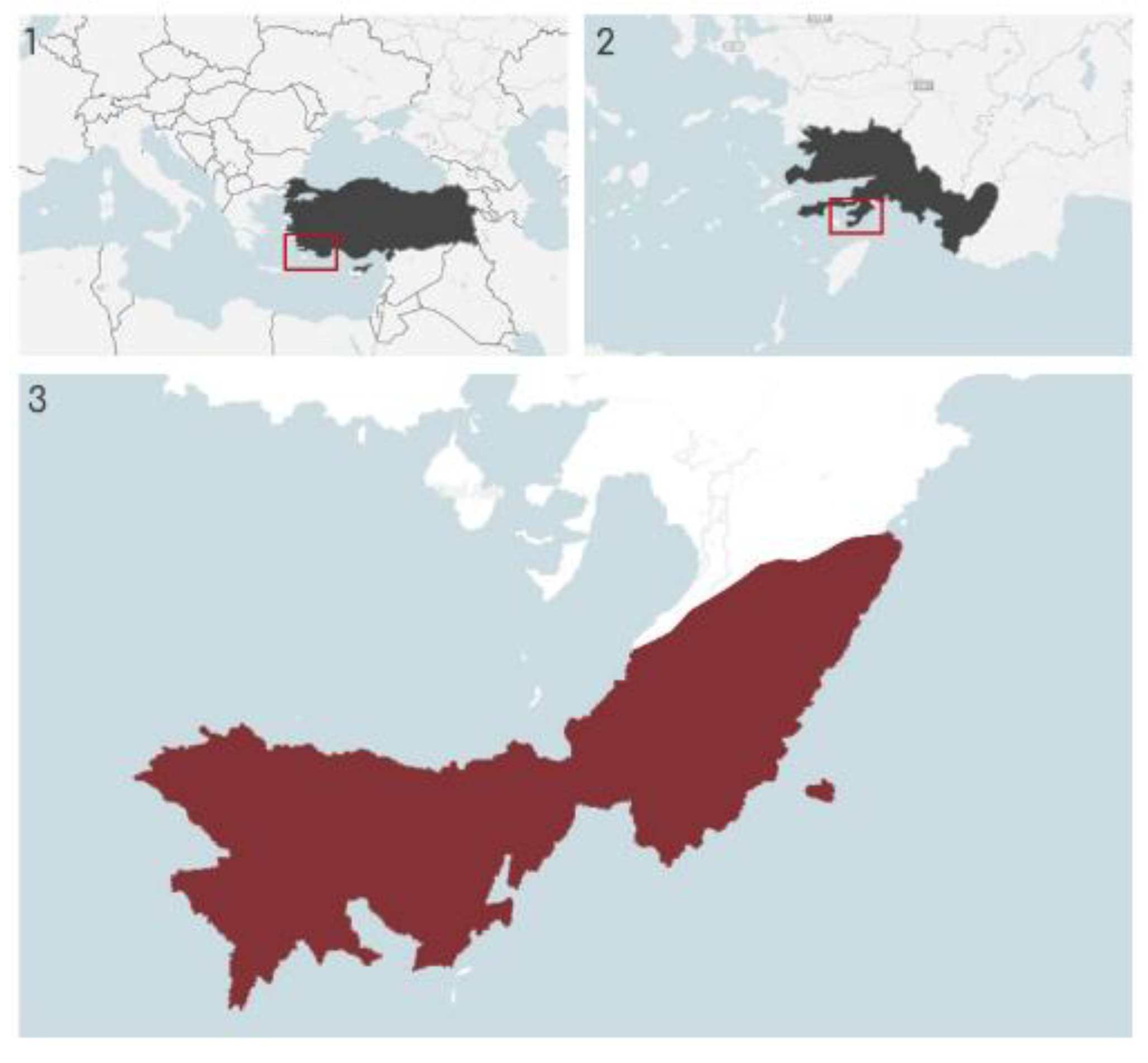
Figure 2.
View of the Sindilli Plain where Fenaket settlements are located from the Phoenix Acropolis.
Figure 2.
View of the Sindilli Plain where Fenaket settlements are located from the Phoenix Acropolis.
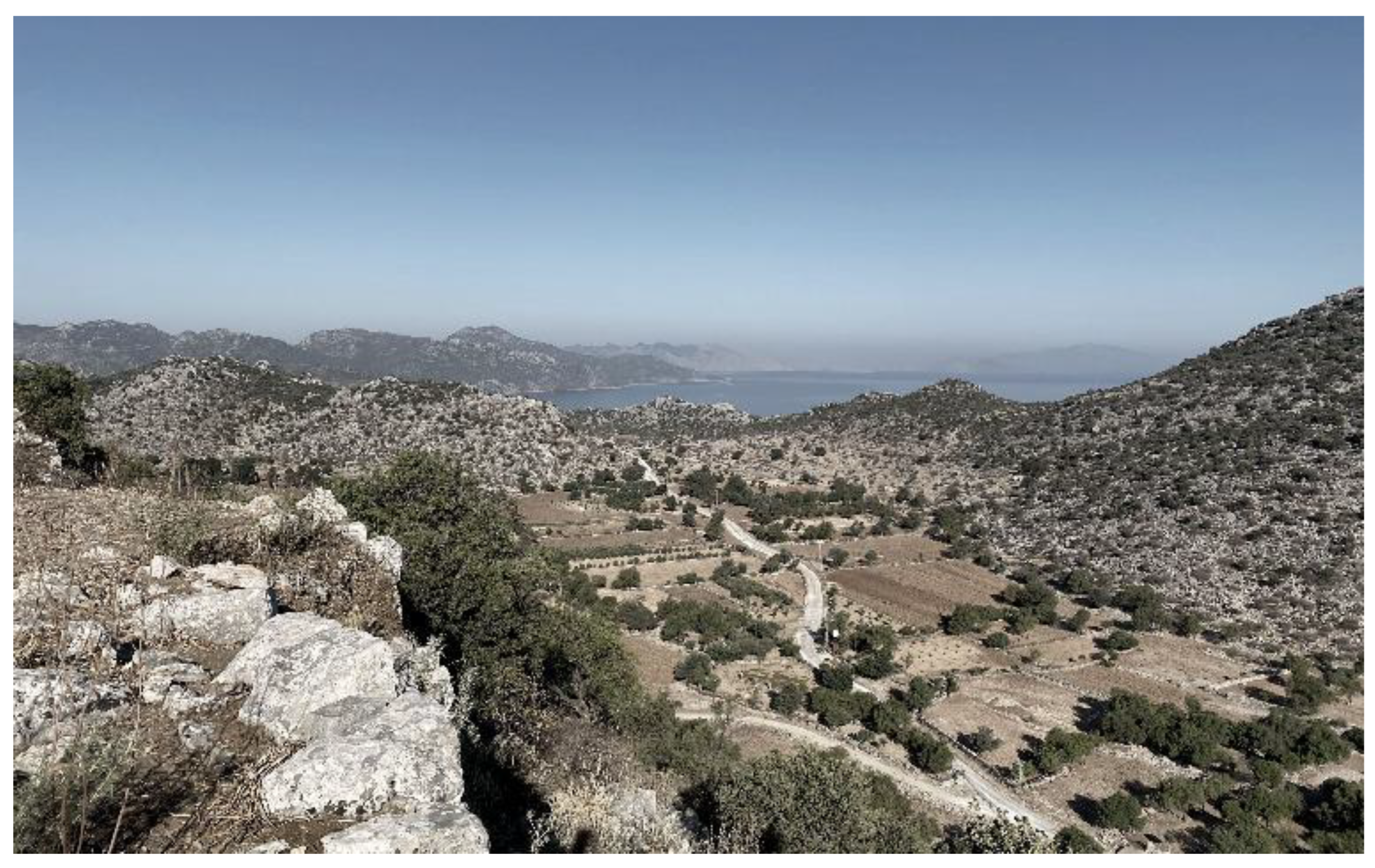
Figure 3.
Representation of the settlement periods and names mentioned in the study on the map.
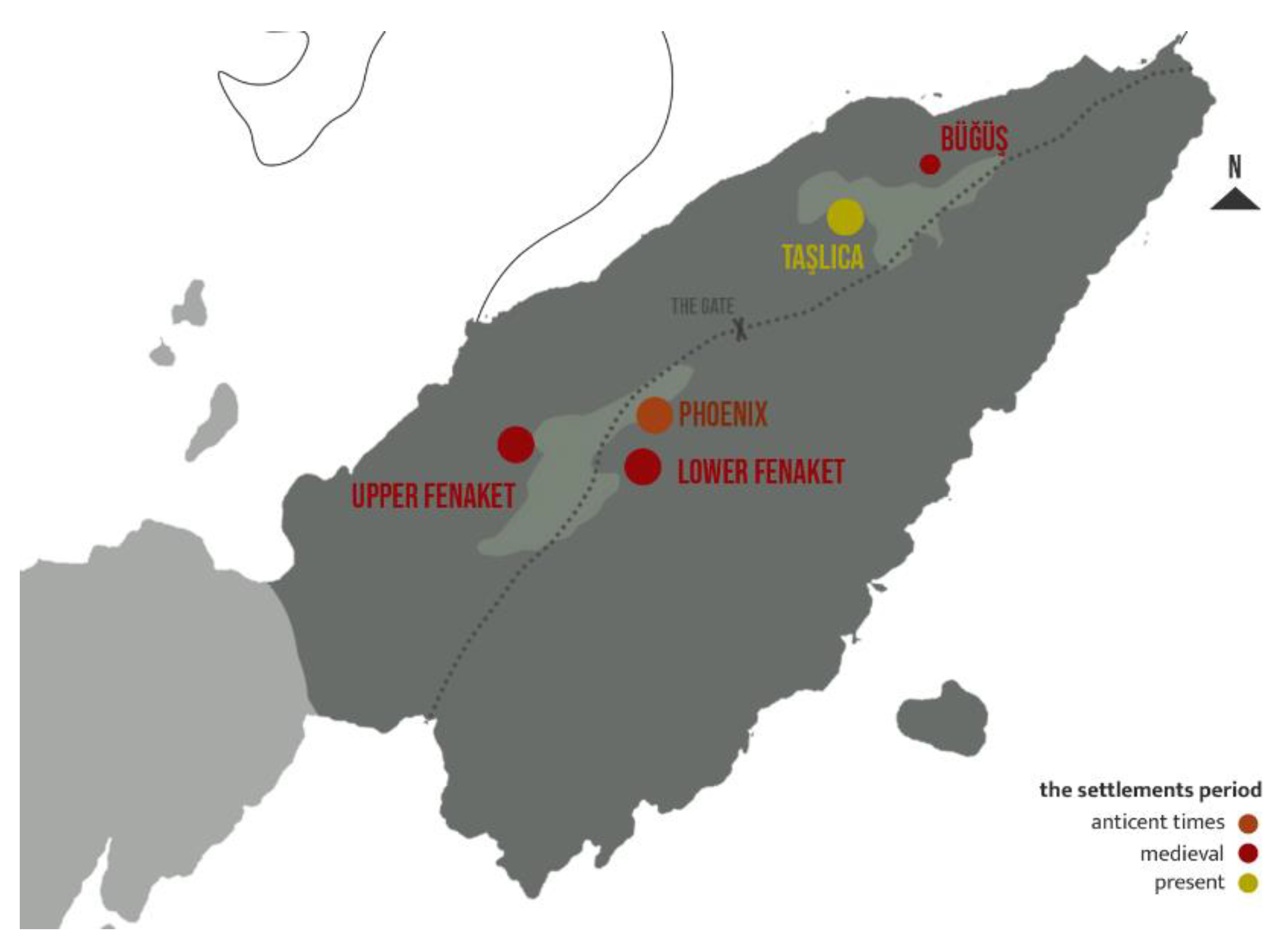
Figure 4.
Display of the mentioned settlements on the map. The historical maps: (1) Kiepert (1908) [66], (2) Vrients (1545) [67], (3) Jansson (1650) [68].
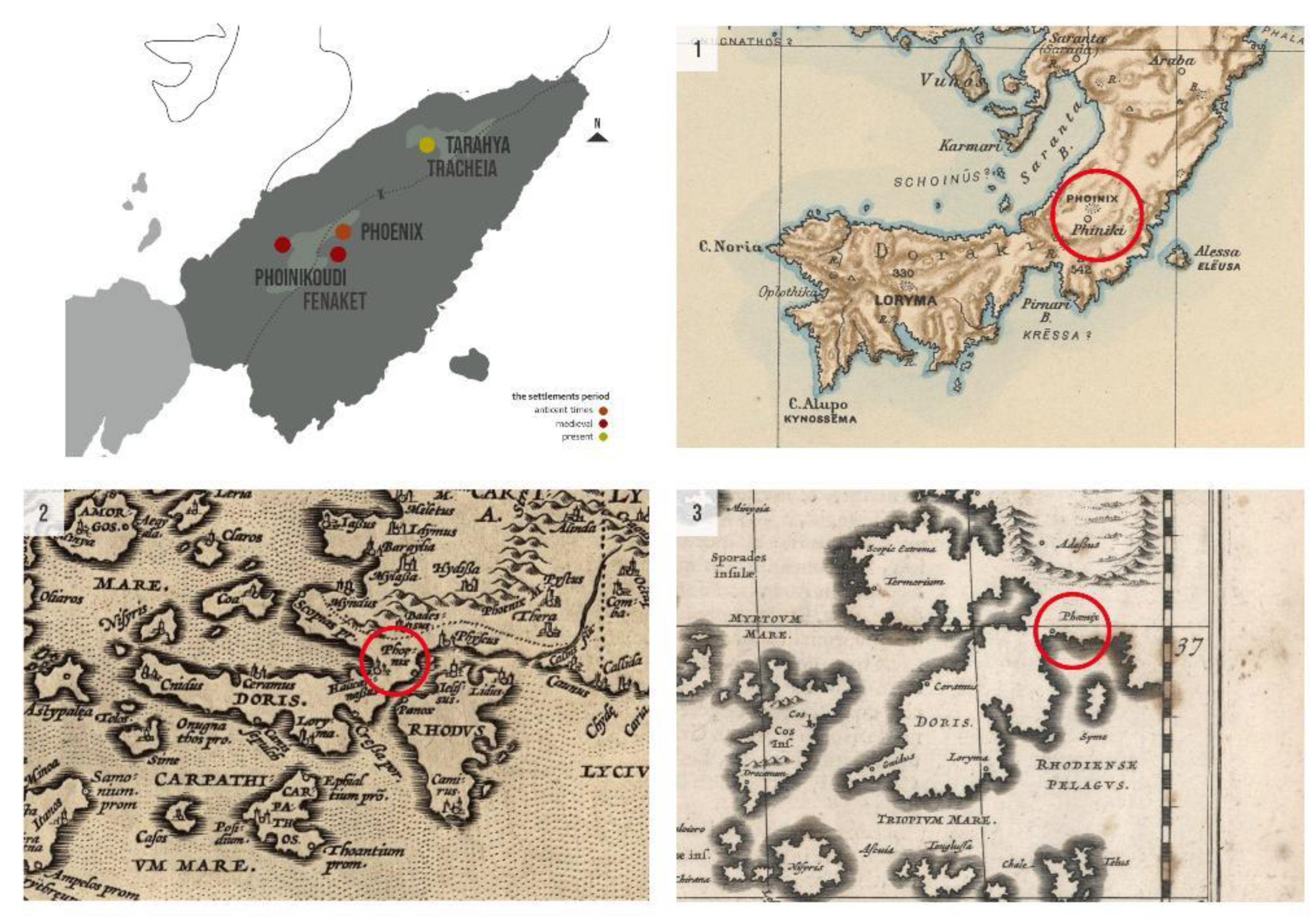
Figure 5.
Sanctuary of Apollon and Eileithyia.
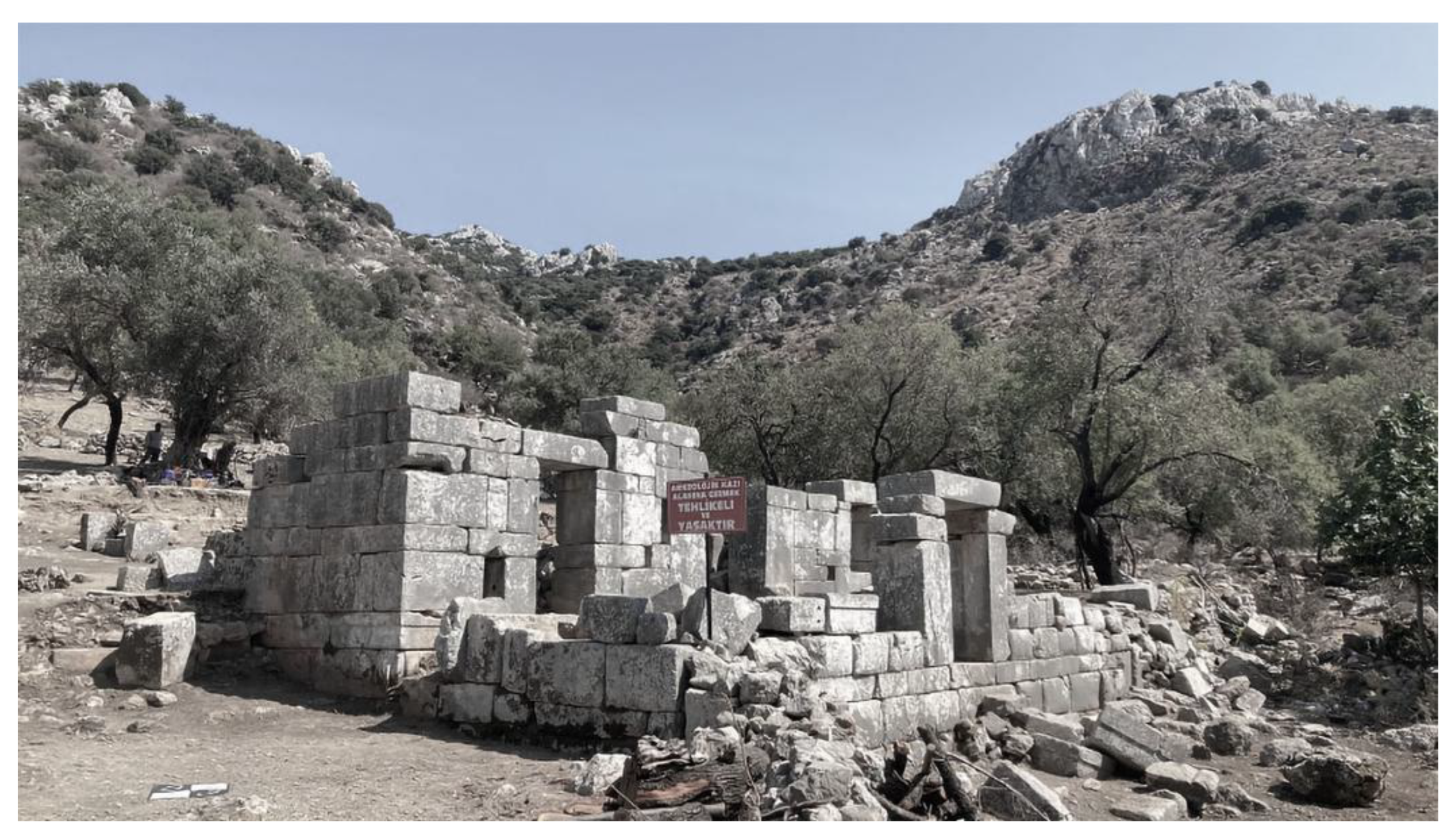
Figure 6.
Timeline of Phoenix Settlements.
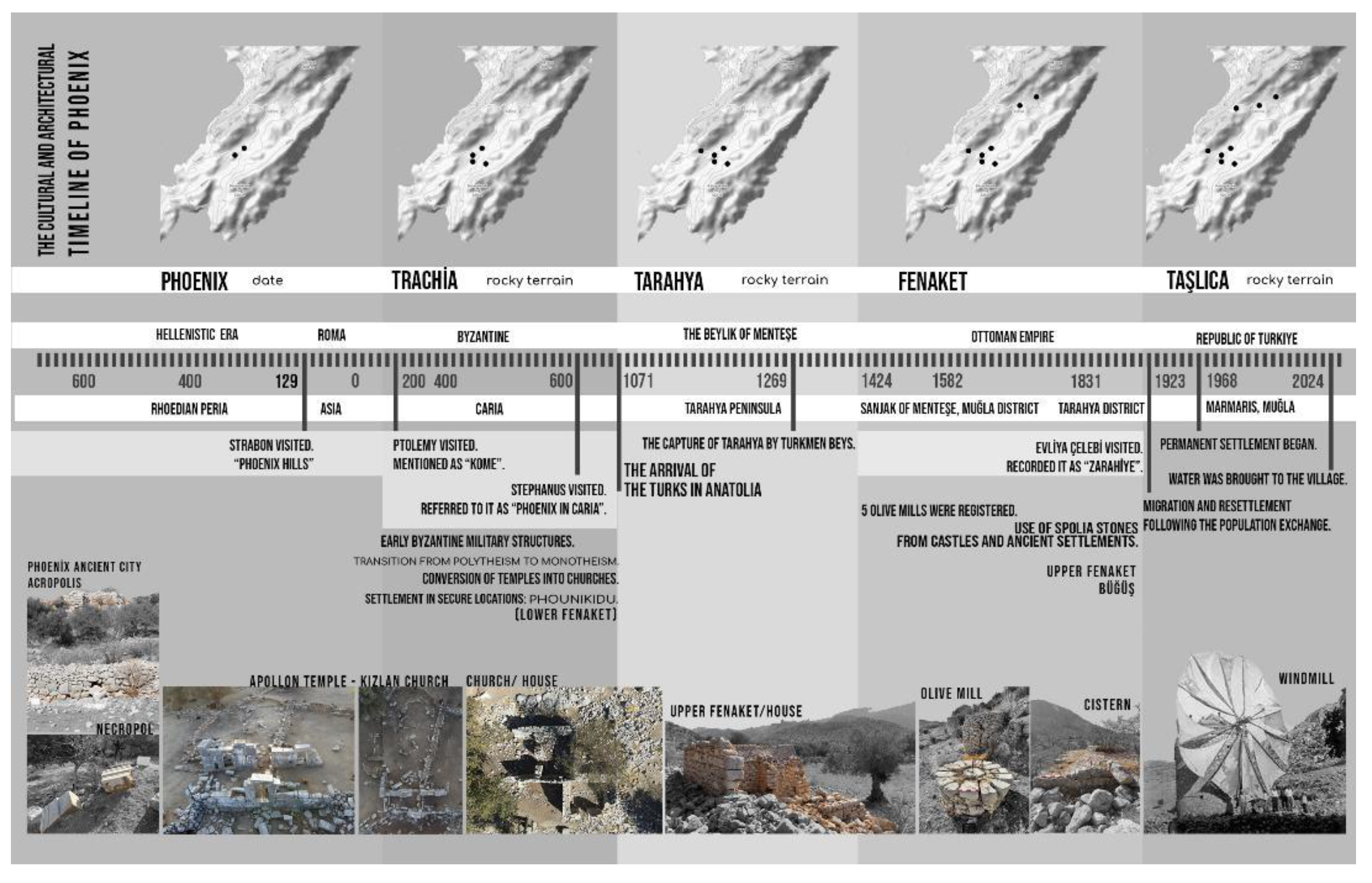
Figure 7.
(a) Orthophoto and Autocad drawing example, (b) digital elevation model example.
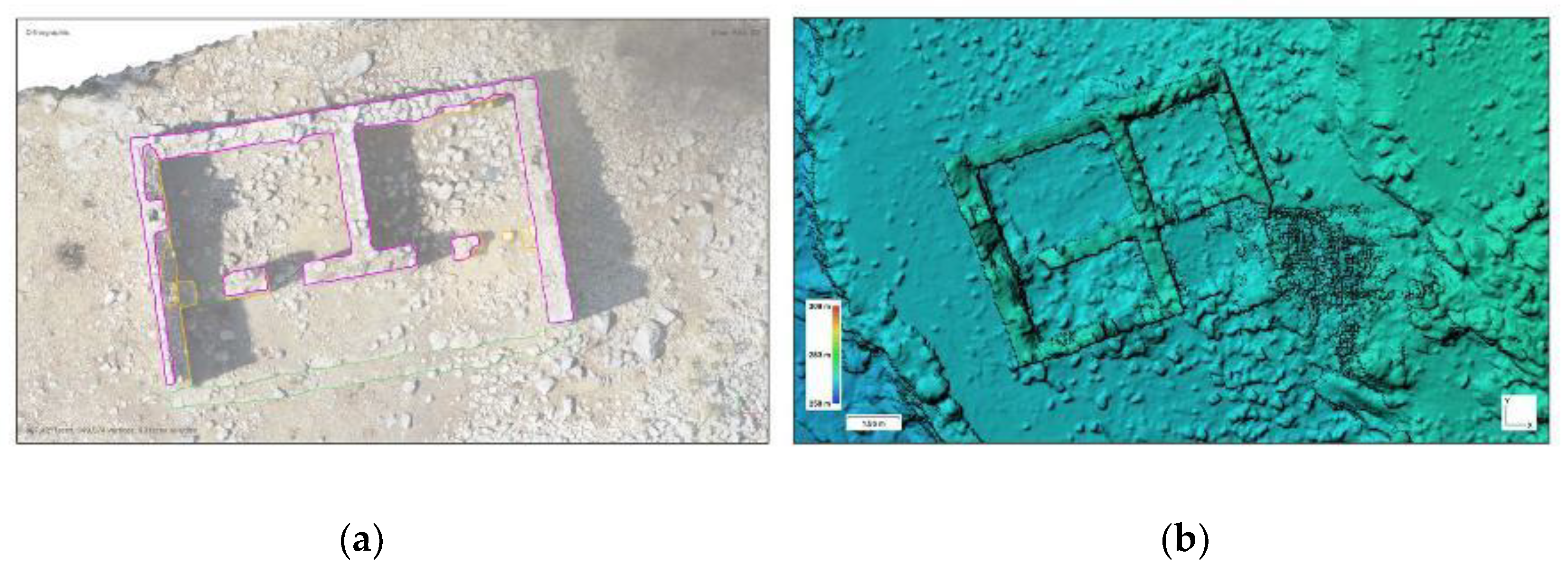
Figure 8.
An example of transferring a 3D Model to a drawing.
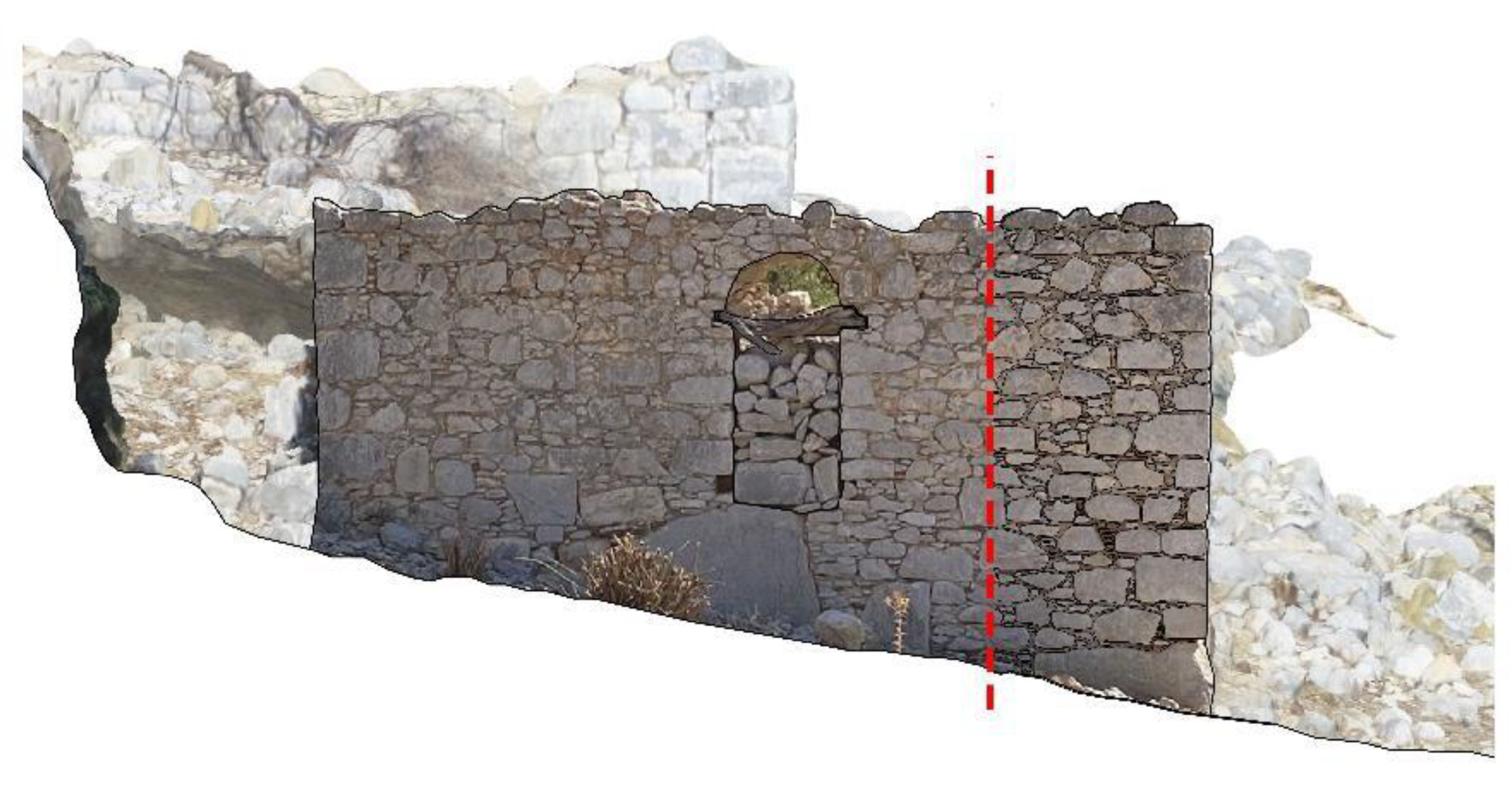
Figure 9.
An example of ruined house from Upper Fenaket and its landscape.
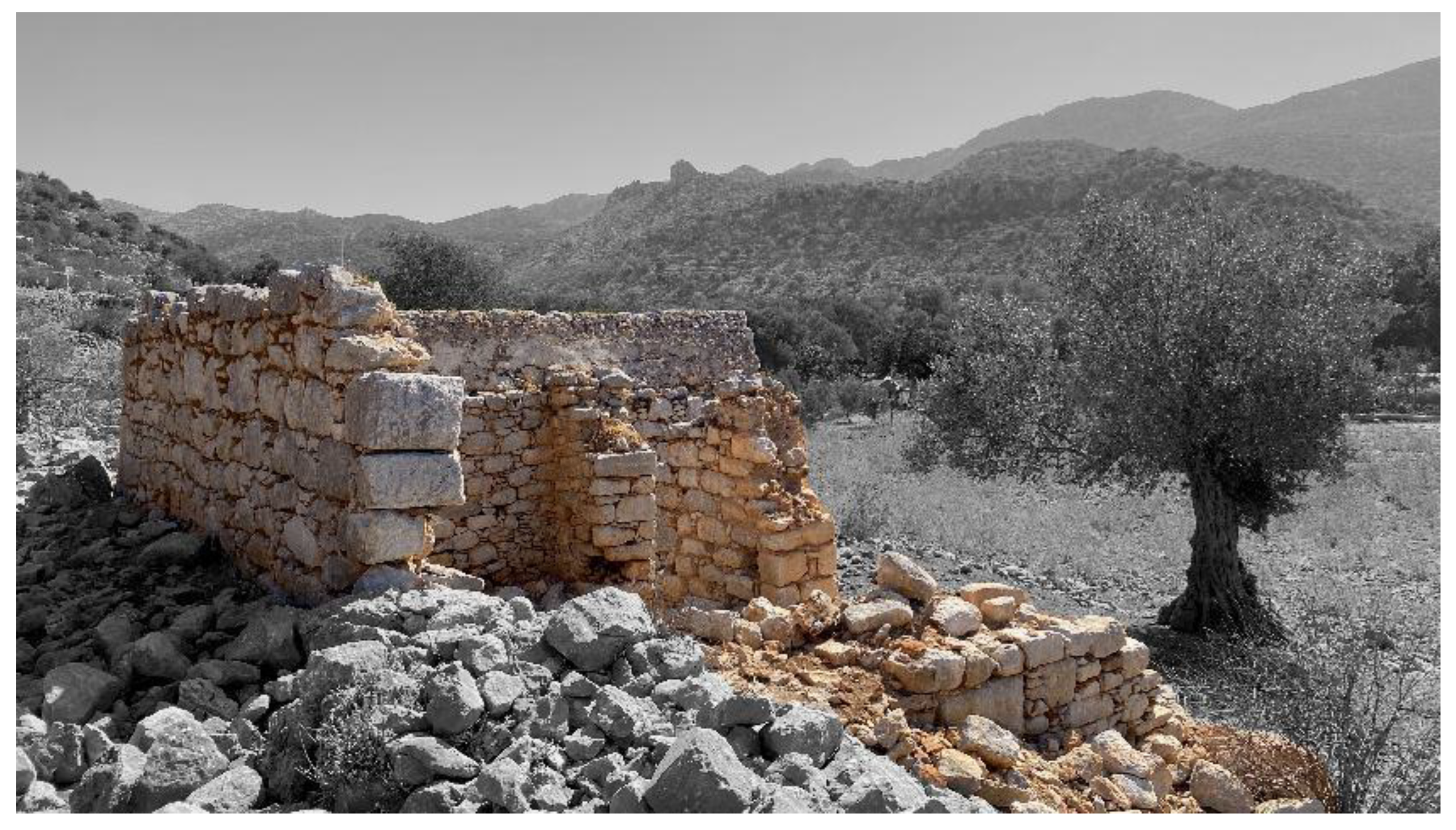
Figure 10.
General floor plans illustrating spatial organization and functional layout of vernacular dwellings in Lower Fenaket and Büğüş.
Figure 10.
General floor plans illustrating spatial organization and functional layout of vernacular dwellings in Lower Fenaket and Büğüş.
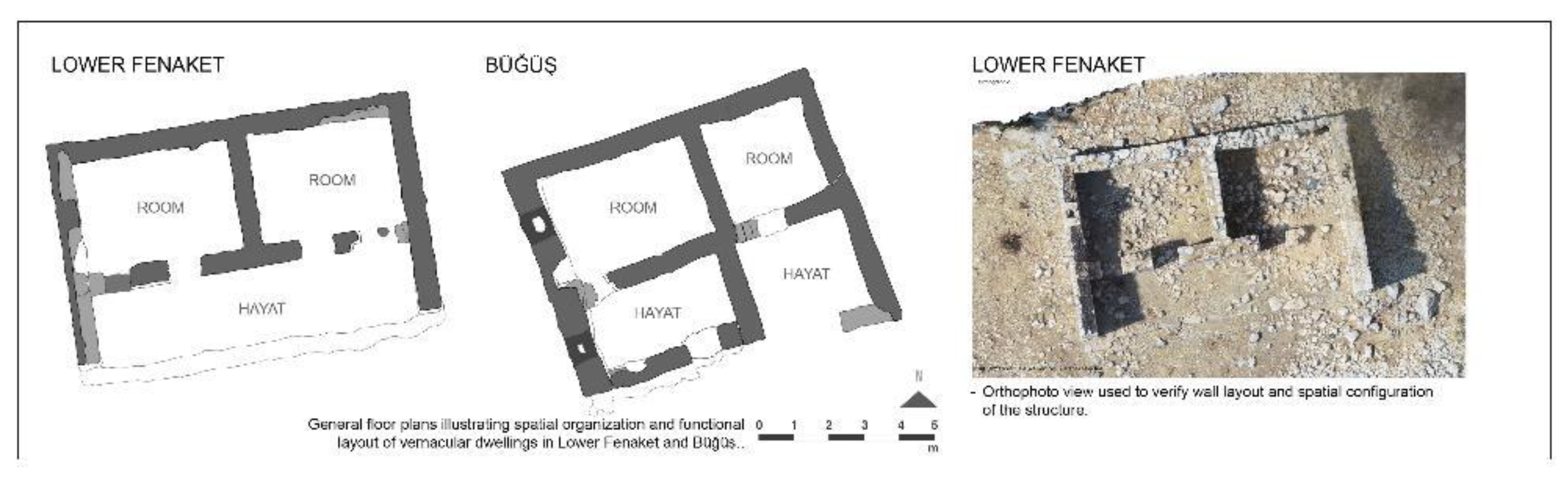
Figure 11.
Stone arrangement corresponding to wall core shown in detailed plan.
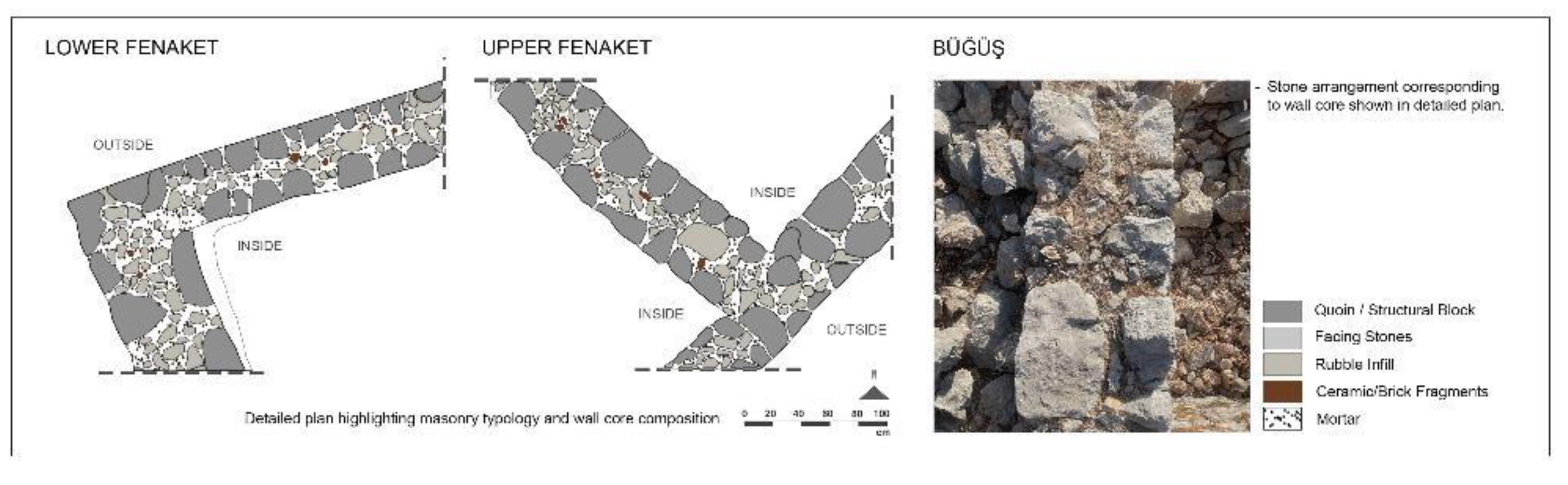
Figure 12.
Elevations with selected detail zones; (a) general 2D elevation, the photogrammetry aligned on the background, (b) detailed and colored wall-corner masonry. (c) detailed and colored an opening, the wedge-shaped voussoirs forming the segmental arch rest on the impost stones.
Figure 12.
Elevations with selected detail zones; (a) general 2D elevation, the photogrammetry aligned on the background, (b) detailed and colored wall-corner masonry. (c) detailed and colored an opening, the wedge-shaped voussoirs forming the segmental arch rest on the impost stones.
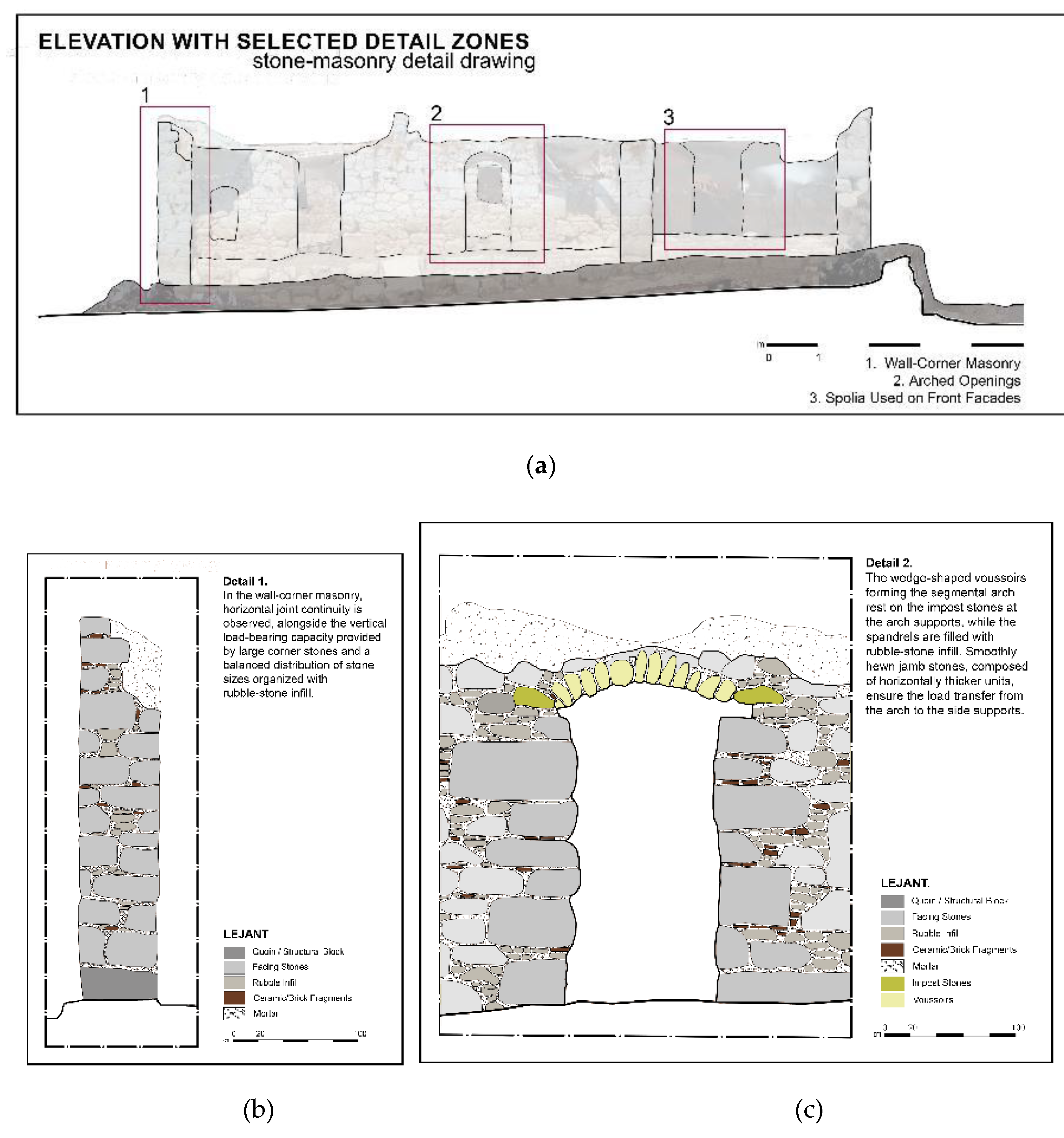
Figure 13.
Versions of the pyramidal tomb block belonging to the ancient period: (a) Monument on the tomb terrace, (b) Use as a wall element in Upper Fenaket, (c) Use as a wall element in Taşlıca.
Figure 13.
Versions of the pyramidal tomb block belonging to the ancient period: (a) Monument on the tomb terrace, (b) Use as a wall element in Upper Fenaket, (c) Use as a wall element in Taşlıca.
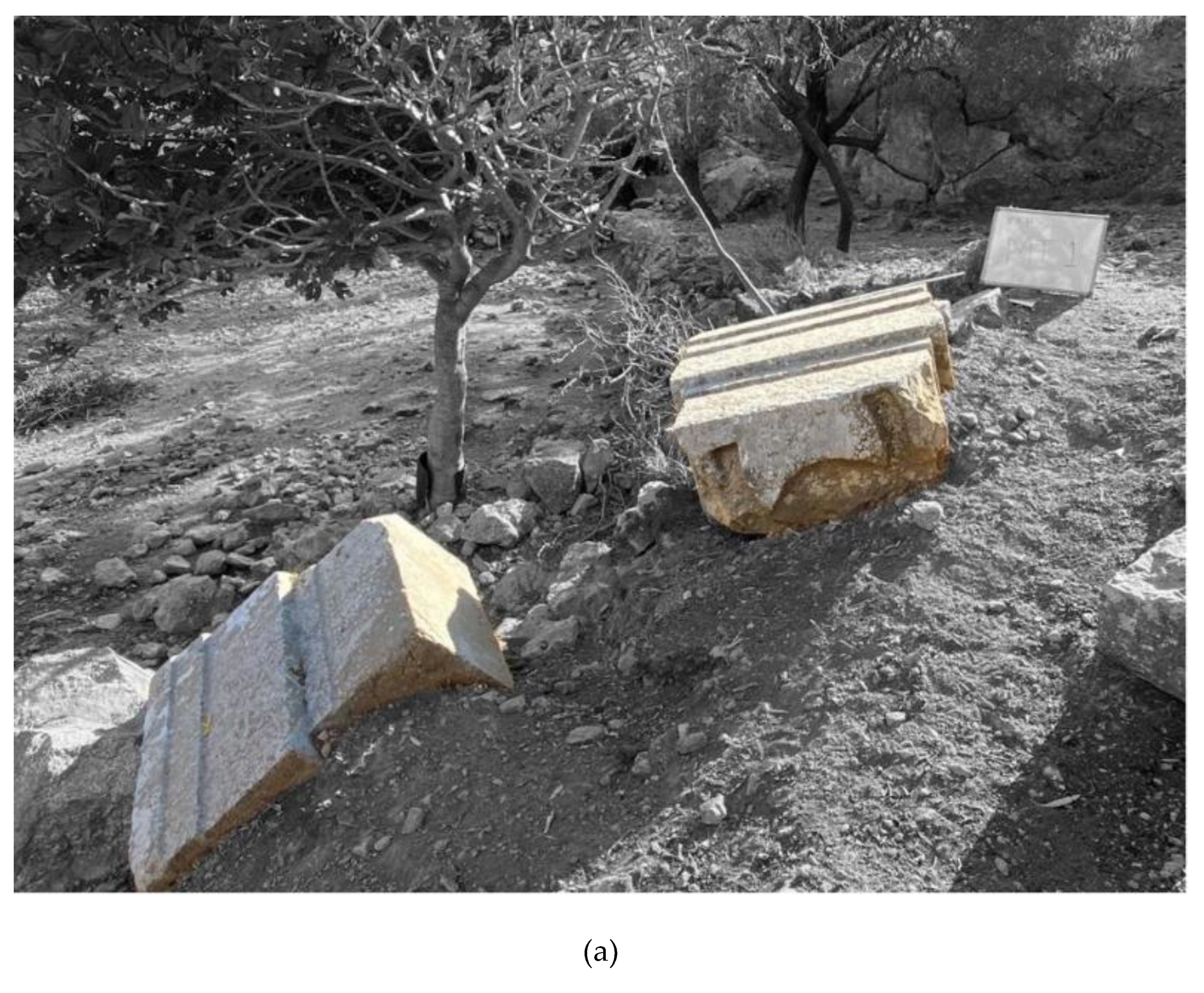
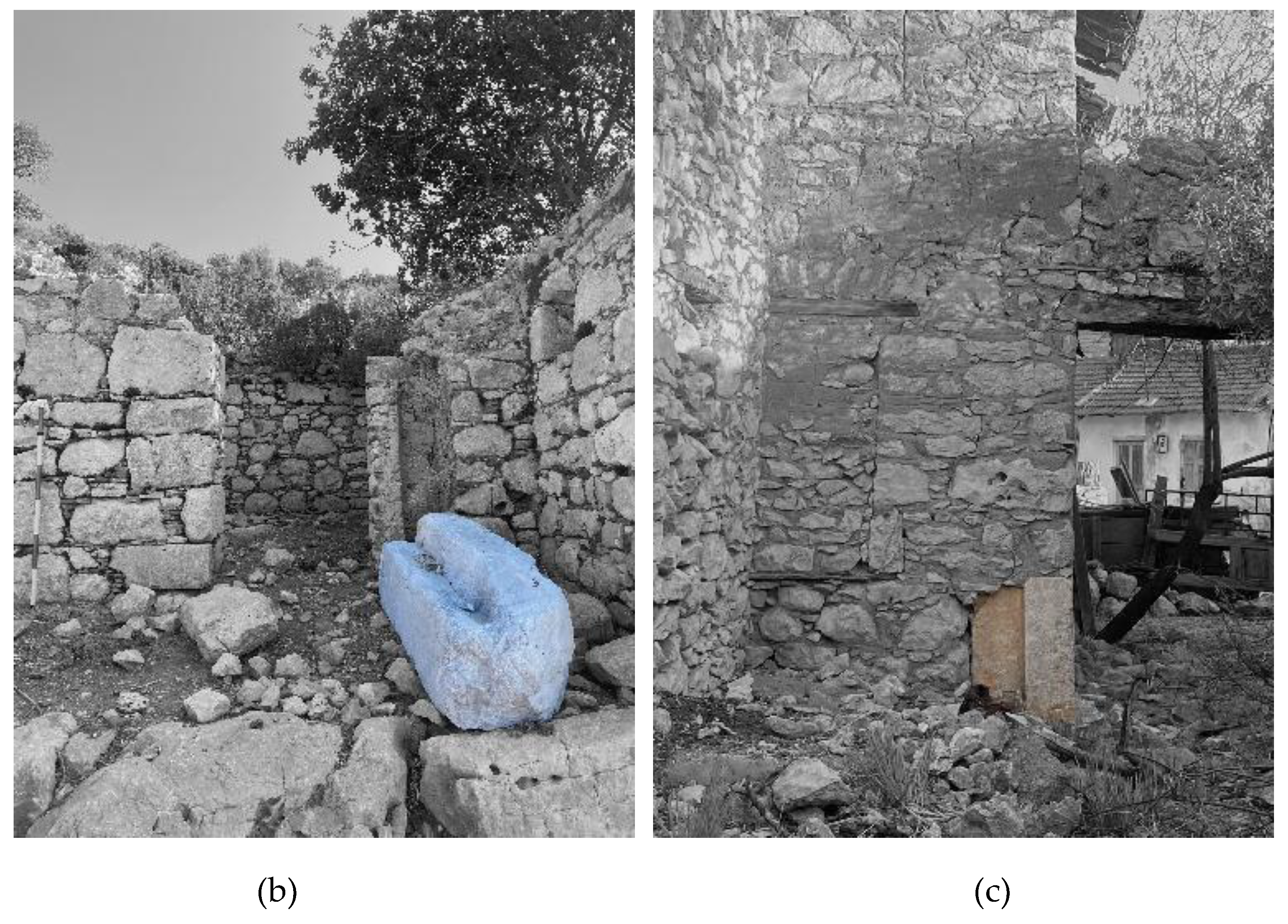
Figure 14.
Spolia using on the façade.
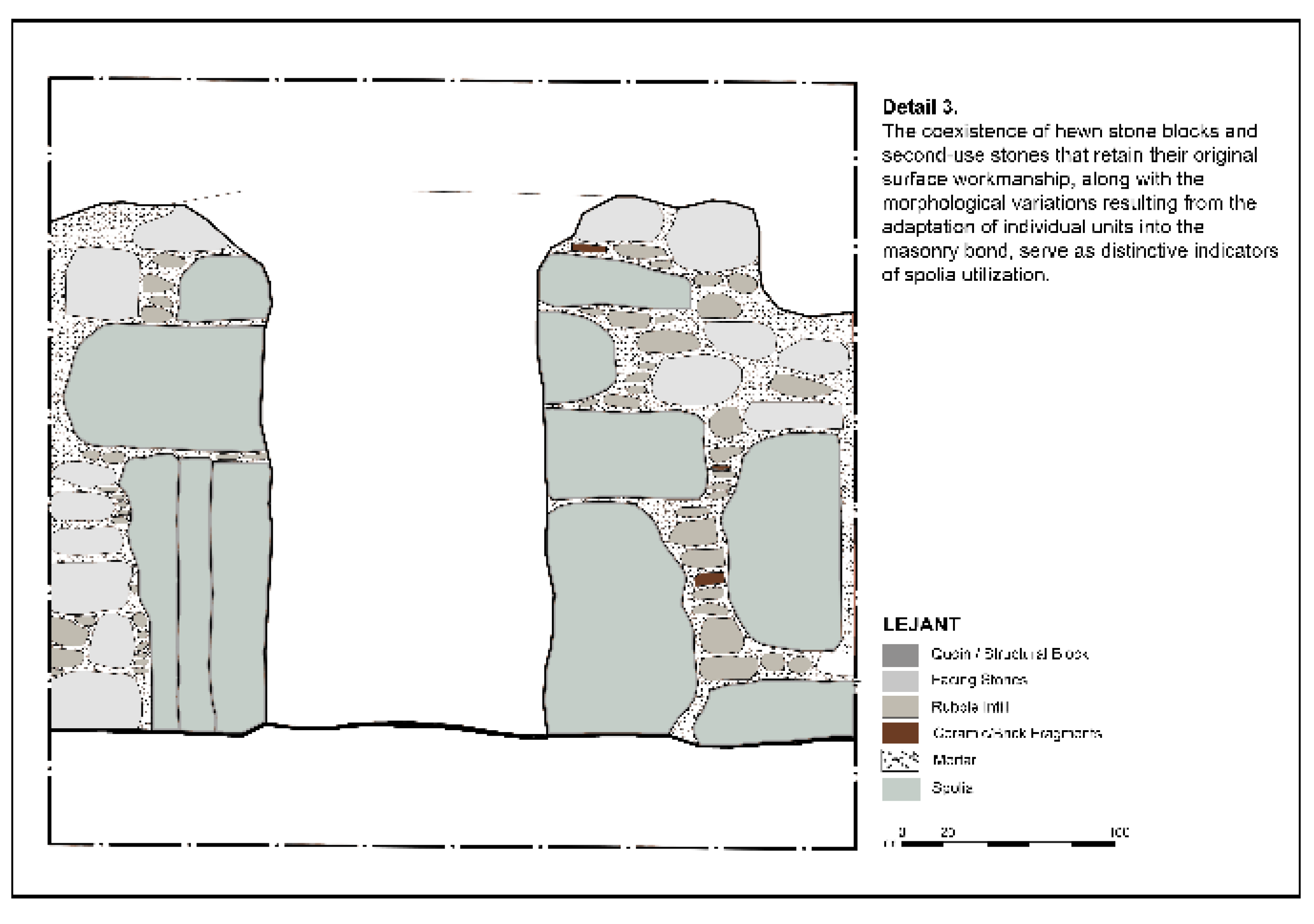
Figure 15.
Wooden elements on a house in Taşlıca. (1) structural elements (2) hatıl for openings. (3) opening frames.
Figure 15.
Wooden elements on a house in Taşlıca. (1) structural elements (2) hatıl for openings. (3) opening frames.
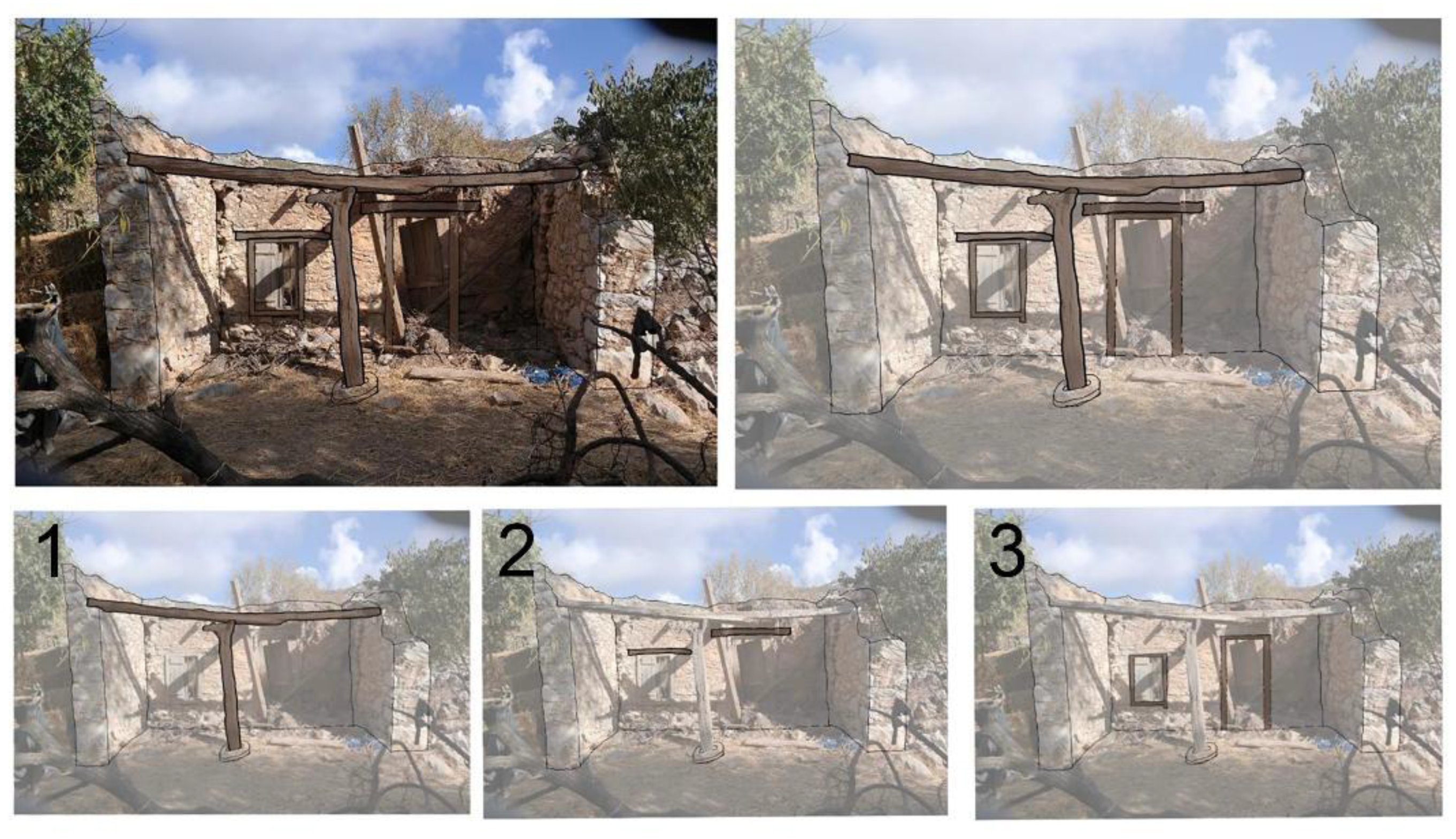
Figure 16.
The source of the sort of earth ‘göktoprak’. (a) The location of the lime wells. (on the left map), (b) Number 1 shows the source the sort of earth ‘sky soil’ – göktoprak.
Figure 16.
The source of the sort of earth ‘göktoprak’. (a) The location of the lime wells. (on the left map), (b) Number 1 shows the source the sort of earth ‘sky soil’ – göktoprak.
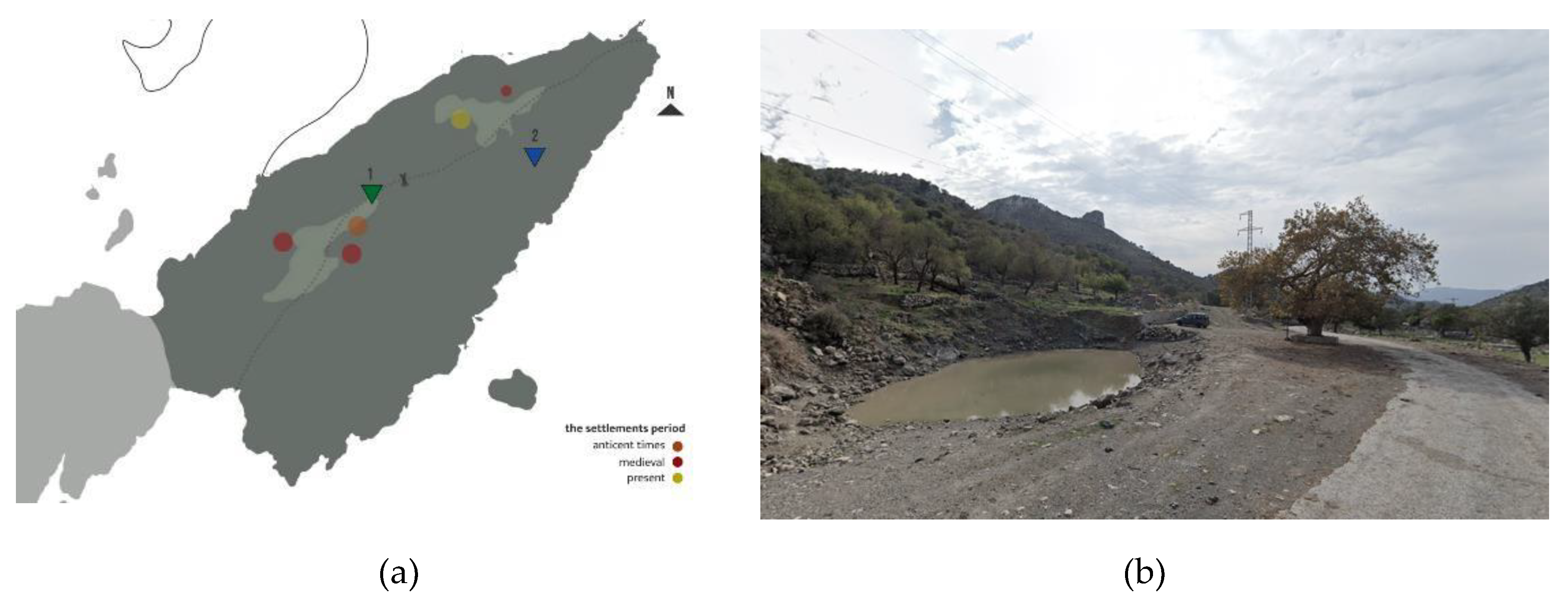

Table 1.
Summarize the methodology.
| Component | Goal/Focus | Methods/Tools/Conceptual Base | Key Outputs/Contribution |
|---|---|---|---|
| A. Research Framework | Examine physical & spatial transformations through the interaction of natural and cultural processes. | Theoretical Base: Cultural Landscape & Entanglement (Hodder, 2012; Turner, 2006). Disciplines Integrated: Architecture, Archaeology, Engineering. Data Sources: Literature review, pre-PAP surveys, post-2020 digital documentation. | Holistic Analytical Framework combining spatial and social dimensions. |
| B. Data Collection | |||
| 1. Oral History & Local Knowledge (Qualitative) | Understand Socio-cultural continuity, the human–construction material–memory triad. | Period: 2023–2024. Participants: 10 ethod: Semi-structured interviews (45–60 min). Themes: Construction & materials, spatial/social change, craft transmission & gendered roles. Tools: Audio recording, Transcription, Thematic coding. |
Documentation of socio-cultural continuity, craft transmission, and gendered roles. |
| 2. Architectural Survey (Quantitative + Qualitative) | Focus on Residential typologies and wall system documentation. | Sites: Upper & Lower Fenaket, Büğüş, Taşlıca. Phases: Preliminary assessment, Mapping & GPS marking, Data collection (photos, sketches, measures). |
Typological Inventory, detailed wall system documentation. |
| 3. Digital Documentation & Analysis (Technological) | Generate precise 3D models, 2D plans, and enable advanced typological analysis. | Tools: DJI Mavic 3, Phantom 4 Pro, GPS. Softwares: Agisoft Metashape, AutoCAD, Photoshop, SketchUp GIS. |
Accurate 3D models, 2D plans, restitution proposals, and typological analysis. |
| C. Data Integration & Analysis | Understand the co-evolution of humans, materials, and the environment via Entanglement. | Integration: Quantitative (spatial) + Qualitative (oral) data. Analysis: Comparative analysis (Fenaket, Büğüş & Taşlıca), GIS & photogrammetry (typology–topography relations), Thematic synthesis (spolia reuse & building continuity). Conceptual Lens: Entanglement. | Spatially and socially contextualized findings on typology–topography relations and building continuity. |
| D. Outputs & Contribution | Provide a replicable model and contribute to rural heritage studies. | Replicable Model for integrating digital documentation + community knowledge. Contribution: Sustainability (material continuity), Identity (craft-based local meaning), Resilience (adaptive reuse and social memory). | |
Disclaimer/Publisher’s Note: The statements, opinions and data contained in all publications are solely those of the individual author(s) and contributor(s) and not of MDPI and/or the editor(s). MDPI and/or the editor(s) disclaim responsibility for any injury to people or property resulting from any ideas, methods, instructions or products referred to in the content. |
© 2026 by the authors. Licensee MDPI, Basel, Switzerland. This article is an open access article distributed under the terms and conditions of the Creative Commons Attribution (CC BY) license.
Copyright: This open access article is published under a Creative Commons CC BY 4.0 license, which permit the free download, distribution, and reuse, provided that the author and preprint are cited in any reuse.


