
Submitted:
06 November 2025
Posted:
07 November 2025
You are already at the latest version
Abstract
The industrial city of Brno is the second largest city in the Czech Republic (402,739 permanent residents as of 31 December 2024) and the core of the country’s third largest metropolitan area, following Prague and the industrial region of Ostrava. Brno has had a metropolitan character since the High Middle Ages, and experienced extraordinary development during the Industrial Revolution in the second half of the 19th century. From a medieval core of just over 1 km², the city expanded in multiple stages to its current area of nearly 230 km². During this expansion, Brno absorbed smaller towns as well as numerous rural municipalities. As a result, large tracts of forest and agricultural land became part of the city. Land adjacent to the historic core was often converted, while the central parts of the incorporated villages retained a relatively rural appearance. Former agricultural plots in these areas were gradually transformed into residential quarters, consisting of villas or apartment buildings. Under state socialism, large housing estates of prefabricated blocks were constructed on the city’s inner periphery. At the same time, farmland was nationalised and consolidated into large-scale cooperative fields. This pattern persisted even after the political changes of 1989. Nevertheless, within the administrative boundaries of Brno, remnants of very old rural landscapes survived, often preserving the parcel structure of medieval small-scale agriculture. These areas are today largely maintained by gardening associations and individual gardeners. Between 2016 and 2020, these remnants were inventoried and classified. A total of 34 sites of varying size were identified. Based on their state of preservation, they were divided into two groups: (1) relatively well-preserved and (2) heavily degraded, through comparison with the situation around 1830, when detailed cadastral mapping was conducted. Well-preserved segments of the pre-industrial landscape were analysed and evaluated in GIS. Their survival has been influenced by natural factors (geological substrate, slope, exposure, elevation, topoclimatic conditions, soil quality), location (distance from the city centre, proximity to forests), land ownership (private, municipal, state), as well as the personal and recreational interests of residents. Interestingly, more remnants of the old landscape have been preserved inside Brno than in its rural surroundings, largely due to the role of urban gardening. Finally, the study assesses the prospects for the continued existence of these landscape relics. From the perspective of city administration and developers, they represent land reserves for other uses. Brno also hosts numerous modern allotment colonies, established either on former agricultural land or on abandoned and degraded sites (e.g. quarries, devastated or reclaimed areas) to meet the recreational needs of the urban population.
Keywords:
rural landscape within the city
; landscape heritage
; pre-industrial segments
; assessment
; classification
; threat
1. Introduction
Accelerated territorial growth of cities has been a characteristic feature of European landscapes since the Industrial Revolution. Urban expansion has taken very diverse forms depending on the economic situation of the country, the region, and the city itself, as well as on local natural conditions, demographic dynamics, political frameworks, and many other factors. This growth has always involved the absorption of rural land previously influenced by the city only indirectly, primarily through economic relations between town and countryside.
Former rural areas became integrated into the city mainly through residential development, transport networks, and technical infrastructure. Yet incorporation does not necessarily mean that no traces of the rural landscape remain once it becomes part of the city. In developed countries, the process of urban expansion is regulated and controlled in various ways. The key instrument is the urban plan, which predetermines how different parts of the incorporated rural landscape will be used. This process, however, requires that incorporation be addressed primarily at the administrative level.
Today, we increasingly observe the opposite phenomenon: suburbanisation, which brings urban features into the countryside without administrative annexation. In such cases, a rural municipality may become “urbanised” in terms of its built environment (construction of urban-type housing and infrastructure), its technological connections (linking local utilities to city networks), and even its population psychology (a growing share of residents tied economically and socially to a nearby city).
During the Industrial Revolution—particularly after 1850 in the Czech lands—urban growth occurred largely through administrative measures that annexed rural municipalities to medieval-founded cities. Until the 1950s, rural settlements were characterised by finely divided plots of agricultural land, including arable fields, orchards, meadows, vineyards in favourable conditions, and forests. Under state socialism, collectivisation transformed these smallholdings into vast cooperative fields cultivated by machinery. However, certain pockets of small-scale parcel structures survived, usually in areas where natural conditions limited mechanised farming, or where consolidation pressures had already been met and some land was left with its original owners.
The fate of such rural land-use structures differed markedly between municipalities that were annexed to cities. In Brno, the persistence of segments of rural landscapes offers an opportunity to examine the reasons for their survival and to assess the risks threatening their continued existence. It should be emphasised that many formerly rural plots underwent partial conversion yet retained agricultural functions within the city. In some cases, they were transformed into allotment colonies, which represent a continuity of rural land use, unlike modern recreational gardening sites.
This paper focuses on urban gardening carried out on areas originally used for agriculture before they were surrounded by urban development. As Brno expanded, it absorbed parts of the rural landscape with a land-parcel structure distinct from that of the city. These remnants survive today, serving both food production and ornamental gardening, and have variously resisted urbanisation. Their preservation has been influenced by natural conditions (slope, aspect, soil quality, topoclimate, geological suitability for construction) as well as by the protective role of gardening associations. By leasing and intensively using such land, these associations not only maintained its rural character but also ensured its recognition as part of the city’s green infrastructure.
2. Materials and Methods
2.1. Urban Gardening as a Specific Form of Land Use in Cities
Gardening within urban settlements is not a new phenomenon. Gardens have accompanied human habitation since antiquity. From the early Middle Ages onwards, monasteries and noble residences were surrounded by gardens. Their functions were not solely aesthetic: they also supplied vegetables, fruit, and medicinal herbs (e.g., Zeven, 1994; Hunt, 1994; Thacker, 1985; Carroll, 2003; Hunt, 2014; Uglow, 2012). A significant milestone in the spread of allotment colonies was the 19th century, when gardening also became common among the middle classes (e.g., Constantine, 1981; Appel et al., 2011; Bell, Fox-Kämper, Keshavarz, Drilling, Noori, 2016).
The establishment of allotment colonies increased substantially during the Industrial Revolution, when large numbers of rural inhabitants moved into cities. Gardens were typically located near working-class districts and served not only for subsistence vegetable production but also as an important social and community-building space (Tóth, Duží, Vávra et al., 2018). With the expansion of urban construction, many such colonies disappeared, though some still exist today—for example in Leipzig (Germany), Lviv (Ukraine), and Ljubljana (Slovenia), where they are recognised as part of cultural heritage (Jakše, Alič & Jereb-Bolka, 2011). The significance of gardening for both self-sufficiency and social life is also confirmed by recent research (Bell, Fox-Kämper, Keshavarz, Benson, Caputo, Noori, Voigt, eds., 2016; Cabannes & Raposo, 2013; Beyer et al., 2014).
The current popularity of urban gardening in Western cities is reflected in the abundance of dedicated websites. A common justification for these initiatives is the ambition to “help nature return to the city” (Hoegl, Leisure trend Gardening, 2025). Yet this is more of a marketing slogan than a reality, since “nature” in its ecological complexity never existed in cities. Rather, what lies behind this trend is a desire for greenery and for productive activity with both practical and aesthetic outcomes. The practical outcomes are represented by the cultivation of home-grown fruit and vegetables (Huertocity. Greening la Ciudad, 2025; British Academy of Garden Design, 2025; Gardeningknowhow, 2025), while the aesthetic side relates to the growing and arrangement of flowers and shrubs (Urban Garden Tour, 2025), contributing to stress relief (Serena Lee, Living & mothering in line with nature, 2025).
A distinctive feature of modern urban gardening is the creation and care of gardens in very limited spaces: in front of houses, backyards, balconies, rooftops, or in hanging containers (Will, 2025). Such “miniaturisation” can be achieved in multiple ways (Quora, 2025):
1. container gardening, 2. tiered or vertical stands, 3. community gardens, 4. rooftop gardens, 5. hydroponics and aquaponics (soil-free systems), 6. miniature garden beds divided into sectors for individual plants, 7. balcony flower boxes,, 8. microgreens and sprouts grown on window sills, 9. intercropping and companion planting (combining fast- and slow-growing species).
The theoretical inspiration for greening cities derives from Ebenezer Howard’s concept of the Garden City, which envisioned human life in harmony with nature (European Heritage Days, 2025). Whether public or private, the “Green City” concept essentially rests on artificially reintroducing elements of nature into an already built or planned urban fabric.
Numerous studies have addressed urban gardens and gardening, though they have generally approached the subject from historical, architectural, health-related (e.g., Unruh, 2002; Soga et al., 2017a; Soga, Gaston & Yamaura, 2017), or sociological perspectives (e.g., Kiesling & Manning, 2010; Firth et al., 2011). More recently, studies have examined gardening within the broader framework of urban agriculture (e.g., Duží & Frantál, 2017; Rojo, 2017; Koopmans et al., 2017; Pölling et al., 2017; Teixeira, 1993; Veenhuizen, 2006). Among the currently fashionable trends are so-called community gardens, which are predominantly interpreted as a sociological phenomenon (Firth, 2011; Soga et al., 2017a).
The aim of this study was to investigate the reasons why certain areas of ancient, pre-industrial rural agricultural landscape larger than 10 ha have survived within Brno. These areas were already in existence in the mid-19th century, during the first comprehensive land-use mapping in the Czech lands—the so-called Stable Cadastre. A further objective was to assess their present state, in which they predominantly serve the needs of urban gardening.
A related aim was to evaluate the current condition of these areas, identify the factors threatening them, document the processes leading to their transformation or destruction, and assess the role of urban gardening in their preservation or decline.
2.2. Brno City: Historical Development Data
Brno is the second-largest city in the Czech Republic, with a population fluctuating around 400,000 since the 1990s. The city lies at the interface between the Hercynian Bohemian Massif and the Tertiary Western Carpathians. About three-quarters of Brno’s territory is situated in the hilly terrain of the Brno Highlands (part of the Bohemian Massif) to the north, northwest, west, and southwest. The remaining quarter, in the south and southeast, consists of flat lowlands belonging to the Dyje–Svratka Valley, a unit of the Outer Western Carpathian depressions. The city’s elevation ranges between 190 and 497 m a.s.l. (Figure 1).
Within Brno’s territory, several major European natural regions converge along a northwest–southeast transect: geological structures (the Paleozoic Bohemian Massif and the Tertiary Alpine system), landforms (Variscan Bohemian Highlands and Pre-Carpathian Lowlands), soils (Hercynian Cambisols and Danubian Mollisols), and biota (Hercynian mixed deciduous forests and Pannonian steppe/forest-steppe). The city also lies on an important climatic boundary between relatively humid, moderately warm-to-cool conditions and relatively dry, warm conditions.
Human settlement in the Brno area dates back to the Neolithic. The medieval core of the city (141 ha) was established on a hill above wetlands (“brna” in Czech language) at the confluence of the Svratka, Ponávka, and Svitava rivers. The first written record of Brno dates to 1091. Between 1231 and 1237, four independent settlements merged to form a town, later fortified with walls. In 1243, the Czech king granted Brno the status of a royal town. During the Middle Ages, Brno shared the role of Moravian metropolis with Znojmo and Olomouc, later only with Olomouc. From 1642 until 1918, Brno was the sole capital of Moravia within the Czech Crown Lands and the Habsburg Monarchy, and later in interwar Czechoslovakia (1918–1939). During the Nazi occupation (1939–1945), it was the administrative centre of Moravia within the Protectorate of Bohemia and Moravia. Following administrative reforms in 1948, Brno has permanently held the status of a regional capital, although regional boundaries have changed several times.
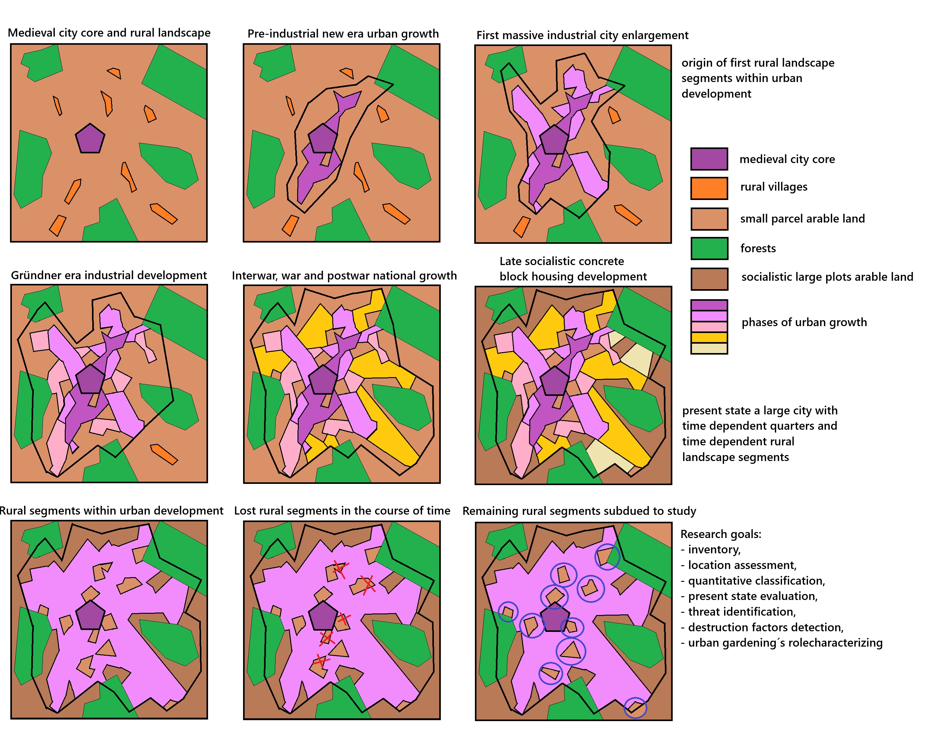
Throughout its history, Brno has expanded territorially (Figure 2), annexing rural municipalities. Most of their original cadastral territories have since been built over, but some preserved their rural land structure and patterns of use. Because these segments date from before the main wave of the Industrial Revolution in Moravia (after 1850), they represent relics of pre-industrial landscapes within the city.
In the second half of the 19th century, Brno became one of the most important industrial cities of Austria-Hungary. Its territorial growth reflected its increasing administrative and economic importance. The first annexation in 1850 incorporated nine suburban municipalities into the historic centre (1.19 km2), expanding the city to 21.36 km2 with about 70,000 inhabitants. These suburbs had a characteristic strip-like parcel division. Only two areas of rural land from this annexation have survived in relatively unchanged form, while most agricultural land was later replaced by residential, administrative, transport, or commercial development.
A major expansion occurred in 1919, when 23 municipalities, including two towns, were annexed. This nearly doubled the city’s area to 124.33 km2 and raised the population from 130,000 to approximately 222,000. Twelve preserved segments with a near pre-industrial land-use structure survive from this annexation, while four more show partial survival, having since been subdivided or redeveloped into residential or recreational allotment colonies.
During the German occupation, the town of Líšeň was annexed in 1944, increasing Brno’s area to 139.93 km2. Líšeň contained large industrial facilities and extensive small fields. One segment has remained relatively intact; two others underwent destructive change—plots were subdivided into small gardens or became overgrown on steep slopes.
Further expansion occurred in 1960 under state socialism, raising Brno’s area to 179.80 km2. Only three cadastral areas were affected: a small agricultural area to the south and extensive forests, recreational zones around the Brno Reservoir, and farmland to the northwest. By then, arable land had already been consolidated into large cooperative fields. Only gardens adjacent to built-up areas retained their old land-use structure. Large areas were later covered by housing estates, especially after 1970.
Two further expansions in 1971 (to 228.48 km2) and 1980 (to 229.64 km2) brought more land, mostly forests to the north and west (important for recreation) and flat farmland in the south (designated for industrial development). Again, most arable land was consolidated into large uniform fields, while older orchard, vineyard, and allotment areas continued to preserve the appearance and use of rural landscapes.
Land use within Brno’s current boundaries is highly diverse, reflecting the city’s size and significance (Table 1, Figure 3). Gardens cover 8.96% of the city’s area, or 27% of its agricultural land. The majority of these gardens are located on former rural parcels with historic small-scale land division.
Brno has a long tradition of gardening. Through territorial growth, it absorbed areas of rural landscape with preserved structures and garden-linked development, but also open farmland in both flat and hilly terrain. Particularly in southeastern districts with favourable conditions (e.g., Líšeň, Tuřany, annexed in the early 20th century), gardens supplied fresh vegetables not only for home consumption but also for sale at local markets. The best-known marketplace, the Zelný trh (“Cabbage Market”), still functions today. Small fruit was also sold for industrial processing. More recently, produce has found outlets at farmers’ markets.
Over the last 30 years, gardening has shifted from a primarily productive function to a recreational and leisure activity, with production taking a secondary role. Nonetheless, in the context of “greening” everyday life and the growing demand for healthy food, productive functions have been regaining importance. Fresh vegetables and fruit are now cultivated not only for ecological reasons but increasingly also for economic ones.
2.3. Inventory of Pre-Industrial Rural Landscape Remnants
The rural landscape areas that have since been largely transformed into gardens have undergone dynamic development over time. Where such plots are located within built-up districts of family houses—as private gardens—or in inner courtyards of residential blocks, their current parcel distribution usually bears no visible connection to the former rural field structure. The same applies to allotment colonies created through detailed redistribution of land owned by the city.
In contrast, gardens have been preserved on a larger scale in peripheral districts, particularly where the terrain was and remains unsuitable for efficient agricultural production. However, in some locations (e.g., the Vinohrady district), even such parcels were expropriated in the second half of the 20th century and built over with prefabricated housing estates. Organisationally, today’s allotment colonies may take the form of private ownership, allotments organised under a gardeners’ union, or various associations (Keshavarz & Bell, 2016). Many of these sites adjoin forests or actively managed farmland. Two relatively well-preserved localities with historic field divisions are situated directly within compact urban development.
A specific segment of pre-industrial landscape in Brno can therefore be defined as an area that currently displays: 1. a land-holding structure similar to that before 1850, i.e., prior to the main wave of the Industrial Revolution in the Czech lands, 2. a comparable pattern of land use to that of the same period, 3. a visual appearance broadly consistent with the mid-19th century landscape.
The criterion of “similarity” refers to the persistence of parcel size, shape, and location. While the use of individual plots may have changed, and some parcels have been consolidated or subdivided within “local size norms,” the overall composition and mosaic of land use has remained intact.
It can be assumed that such pre-industrial segments reflect a relatively uninterrupted technical, socio-economic, and cultural development since the post-White Mountain battle era (after 1620), shaped by local natural conditions and the effects of early-modern agricultural innovations. These areas, often relegated to the periphery of subsequent urban development, thus became relics of secondary landscape structures from earlier periods. They largely escaped the deep socio-economic transformations that reshaped the wider rural environment.
The identification of pre-industrial segments followed a sequence of steps (Figure 4). This is followed by a purposeful evaluation of the identified and confirmed segments of the pre-industrial landscape. The process is carried out gradually for individual cadastral areas due to the archiving of old maps according to the cadastral division of the area of interest (Domaas, Austad, Timberlid, Norderhaug, 2003).
Preliminary (on-screen) analysis involved selecting candidate sites through inspection of contemporary orthophotos, focusing on areas characterised by fine-grained parcel mosaics. These were then compared with historical cartographic materials documenting the pre-industrial situation, especially the Stable Cadastre and its derivatives—cadastral sketches and the Second Military (Franciscan) Survey from the first half of the 19th century. Each identified site was subsequently subjected to two stages of evaluation:
Quantitative assessment (1)—classification into three size categories:
A—pre-industrial landscape site (10–50 ha),
B—pre-industrial landscape district (50–100 ha),
C—local pre-industrial landscape (>100 ha).
Qualitative assessment (2)—classification into four preservation categories:
1—Exceptionally well preserved: more than three-quarters of the original field structure and at least half of the historical land uses (including boundaries) remain, with only minor deviations from cadastral maps.
2—Well preserved: more than three-quarters of the field structure survive, though historical land uses have been altered (e.g., arable land converted to meadows, orchards, or vineyards). Boundaries have become overgrown, but the landscape character remains largely unchanged.
3—Satisfactorily preserved: at least half of the field structure persists, though some parcels have been merged. A portion of original land uses survives, but new forms (orchards, vineyards, garden cottages) have been introduced, alongside numerous threats.
X—Without historical value: areas with small-scale division but with fundamentally altered field structures and dominant new land uses (e.g., cottages, swimming pools, sports fields, ornamental gardens) inconsistent with 19th-century maps.
This classification, applied across the historical region of Moravia in eastern Czechia, was based on expert judgement following a unified scheme.
Some localities in category A/1 would merit recognition as cultural heritage; however, none of this quality survive within Brno’s administrative boundaries. Sites in category B/2, while less intact, still retain clear rural features and therefore deserve attention from both the public and city administration. All such sites are, however, under varying levels of threat.
In addition to the 34 historically documented large-scale allotment areas identified in this study, Brno contains numerous other allotment colonies established in the first half of the 20th century (e.g., Kraví hora I and II) as well as many smaller allotment sites scattered across nearly all districts, except in the compactly built-up city centre. These modern colonies were not included in this study, as they do not constitute pre-industrial heritage.
3. Results
3.1. Segments of the Original Rural Landscape within the Current Metropolitan Area
Today, Brno encompasses 48 cadastral units. Analysis of recent colour orthophotos revealed 34 areas of varying size, all characterised by a fine-grained parcel structure typical of the pre-industrial landscape as documented in the Stable Cadastre from the first half of the 19th century. Seventeen of these 34 areas, however, have undergone significant transformations. They retain only partial traces of historical land-use patterns, and many were restructured into small plots with seasonal or permanent housing, falling into the qualitative category “X”.
The Brno metropolitan area expanded through successive annexations, occupying and building over all suitable land. Pre-industrial rural parcels and forested areas thus remained outside the built-up zone. While residential construction dominated the hilly periphery in an arc from the southwest through west and north to the east, industrial and commercial development concentrated in the south and southeast. Steep or rocky terrain largely remained forested, or preserved remnants of rural land division.
Since the transition to a market economy in 1990, these trends have intensified. Although residential construction slowed in scale, it continued primarily in peripheral districts. Commercial and industrial development spread to smaller sites around the inner city, typically on the most accessible and fertile soils. New construction has so far avoided large-scale destruction of fine-grained parcel mosaics. Nevertheless, conversion is taking place in a more subtle, gradual manner, as garden cottages are rebuilt into seasonal or permanent housing.
Currently, 11 of the 17 relatively well-preserved rural segments are located adjacent to forests (see Figure 3), which makes them attractive targets for residential development. Since their soils are of lower agricultural quality, they are less strictly protected under national regulations, making them vulnerable to building pressure despite formal restrictions. As a result, besides forests (legally protected from conversion), large arable fields (prohibited for development), and brownfields (often in unsuitable valley-bottom locations with poor ventilation; cf. Frantál et al., 2015), these rural remnants represent the last major land reserve for potential construction in Brno.
The natural environment of Brno is well represented in a synthetic map of natural landscape units (NLUs), which integrate geology, relief, soil, topoclimate, and hydrological conditions. This map was compiled by the authors from available analytical datasets (www.geology.cz, www.cuzk.cz, http://mapserver-slp.mendelu.cz/). Comparative analysis (Table 2) of the share of each NLU within the city, their proportion of preserved rural segments, and their current degree of urbanisation allows for a qualified assessment of both the reasons behind their survival and their vulnerability to future development.
The conditions responsible for the survival of pre-industrial landscape segments within Brno can be derived from Table 2 (Figure 5). Attention must be directed in particular to those values that reach at least minimal significance. As a conventional threshold, a 5% share may be applied in three respects: (1) the proportion of a given natural environment type within the city’s total area, (2) the share of preserved pre-industrial segments within that environment type, and (3) the proportion of urban development within that type, indicating its attractiveness for construction. For forest cover, the opposite criterion applies: types with at least 50% forest cover are of interest, since this limits their usability for other human activities (except recreation).
In order to evaluate the relationship between natural environment types and the occurrence of preserved pre-industrial landscape segments in Brno, pairs of conditions were established. These pairs (in grey in Table 2) consist of:
- Environment types covering at least 5% of the city’s total area, combined with the occurrence of preserved segments regardless of their proportional share, or
- Environment types in which preserved segments make up at least 5% of the total area of that environment type, regardless of its areal representation within Brno, and
- Environment types that simultaneously meet both conditions, with at least 5% representation of each characteristic (highlighted in grey in Table 2; see figure above).
The tabular overview shows that the preservation of old rural landscapes has been most strongly favoured by:
gentle loess slopes with luvisols and chernozems (17.03% of Brno’s territory, with 16.09% of preserved segments, however, with high competition from development as a threat, row 8),
gentle granite slopes with cambisols (14.01% vs. 17.00%, with high competition from the forest as a barrier to spread, row 11), and
steep granite slopes with shallow cambisols and leptosols (10.47% vs. 18.40%, with extremely high forest competition, row 20).
By contrast, flat relief—plateaus and plains—does not support the survival of old landscapes, usually due to development pressure. The presence of remnants there is significantly lower than the share of flat terrain in Brno’s area (rows 1, 14, 22), because it represents suitable development areas. An interesting case is the concentration of remnants on gentle and steep metabasic slopes with relatively fertile cambisols (rows 13 and 21), although this is likely related to the frequent occurrence of such terrain close to the city centre (Figure 5).
When climatic conditions are considered (Figure 6), a clear preference for relatively warmer positions emerges. On one hand, this reflects the advantage of more favourable temperature regimes; on the other hand, cooler areas were historically forested. In higher and colder elevations, farmland was scarce, and consolidation into large cooperative blocks had occurred earlier (often before annexation to Brno) and more radically. In lower and warmer positions, pressure for consolidation was weaker, most likely due to the far greater supply of agricultural land available for collectivisation.
Within the very warm climatic zone (mean annual temperature up to 10 °C), nine preserved segments occur wholly or partly. The warm climatic zone (8.1–9.0 °C) contains 13 segments. Only four segments extend marginally into the moderately warm zone (Ta < 8 °C), typically at shaded footslopes of valleys.
It is evident that the very warm flatlands close to the historical urban core no longer host preserved pre-industrial landscape segments, as they were lost to intensive urbanisation. By contrast, very warm slopes extend into higher elevations, where steep terrain and less favourable soils made development less attractive, thus enabling remnants of old rural parcels to survive.
The identified segments of the rural pre-industrial landscape serving contemporary urban gardening essentially represent almost every cadastral area of the city.
For analytical purposes, the 34 identified localities were divided into two categories (Figure 3):
- Relatively well-preserved segments—with parcel division and land use comparable to that documented in 19th-century cadastral maps (Table 3).
- Severely degraded segments—where original parcel structures have been almost completely destroyed by re-parcelling, new construction, or abandonment (Table 4).
Relatively well-preserved remnants of rural landscape within the metropolis represent a valuable subject of study, useful for demonstrating the geographical conditions under which they originated and in which they have been preserved to the present day. Many of these very conditions also explain why they have, to some extent, escaped the pressures of urbanisation.
3.2. Examples of Identified Segments of Pre-Industrial Landscape Within the Urban Development
The presented case studies illustrate preserved fragments of the ancient pre-industrial rural agricultural landscape within the Inner City of Brno. These areas represent characteristic examples of landscape heritage that continue to serve urban gardening purposes today.
The locality of Staré Brno, covering 20 hectares, is situated in the city centre on the southern slopes of Žlutý kopec hill. It lies adjacent to the historic settlement of Staré Brno (urbanized since the 12th century) and to the Brno Exhibition Grounds, in close proximity to the medieval urban core (Figure 7). The area was incorporated into the city during its first expansion in 1850.
In the mid-19th century, the land was cultivated in the form of narrow vineyard plots, with smaller areas used as arable fields interspersed with trees. Today, the site is a mosaic of private gardens and allotment colonies, established on leased land owned by the City of Brno and the Heineken brewery. The surrounding urban development dates from the late 19th century and the first half of the 20th century. In the current master plan, however, the area is designated for public amenities and residential development, which puts its continued existence at risk.
The segment of ancient landscape at Židenice–Vinohrady forms a complex of gardens located within the cadastral districts of the Židenice and Vinohrady quarters, on the southwestern and southern slopes of a hill at the edge of the extended inner city. The area was annexed during the most extensive phase of Brno’s expansion in 1919. It covers an area of 43 hectares (Figure 8).
In the mid-19th century, this landscape consisted of a mixture of narrow orchard parcels, meadows, arable fields, and vineyards. Today, it is still composed of privately owned gardens with a similar structure of land use, although the vineyards have largely disappeared while the original plot pattern has been preserved. The locality is bordered on the south and west by a mix of residential buildings of various ages (with many dating to the turn of the 19th and 20th centuries), and on the north and northeast by housing estates of prefabricated apartment blocks constructed in the 1980s. The main threat to this landscape lies in the increasing construction of permanent housing within the area itself, as well as the encroachment of large-scale development projects expanding from its edges.
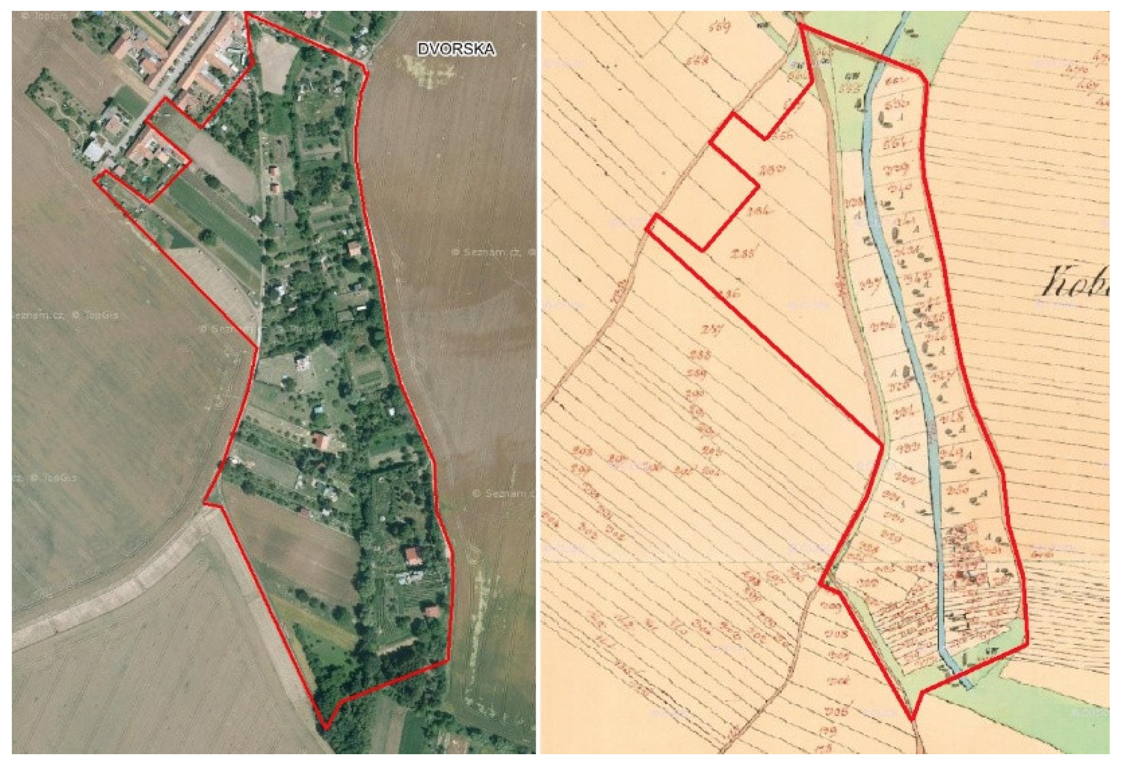
The preserved remnant of the traditional rural cultural landscape of Dvorska is located on the southeastern edge of Brno, within the cadastral district of the same name, which was incorporated into the metropolitan area in 1971. The segment, situated in gently undulating terrain, covers an area of 10.01 hectares. The village itself was established at the end of the 18th century on redistributed lands of a dissolved manorial estate.
In 1835, plots of various sizes sloping gently toward a stream were used predominantly as arable land, while the parcels oriented to the southwest were rich in fruit trees. The original land division has survived to the present day. However, owners now manage their parcels in diverse ways, which is visually reflected in the mosaic of land use. The proportion of arable fields has declined significantly in favour of grass-covered areas. The number of fruit trees and shrubs has increased, and riparian vegetation has developed along the stream. Residential construction has already cut into the northwestern edge of the original farmland, and several houses have been built within the segment itself. Extremely small, fragmented parcels in the southern part have been merged.
Figure 9.
Dvorska. Segment of rural landscape on the outer periphery of Brno, south of the original village, surrounded by large-scale agricultural land. Left: orthophoto from 2015; right: cadastral map from 1835. Source: Mapy.cz, www.mza.cz.
Figure 9.
Dvorska. Segment of rural landscape on the outer periphery of Brno, south of the original village, surrounded by large-scale agricultural land. Left: orthophoto from 2015; right: cadastral map from 1835. Source: Mapy.cz, www.mza.cz.
4. Discussion
A key indicator of risk for the survival of these historical landscape segments is the combination of preserved land-use patterns, forest cover, and urban development within a given natural environment. In other words, the particular mix of these factors can create a critical vulnerability.
The main threat to the persistence of remnants of the old rural landscape (even when transformed into garden plots) is the expansion of built-up areas—primarily residential, and in flat terrain also commercial. In the Czech Republic, forests are legally protected, and obtaining an exemption for permanent forest removal to allow construction is virtually impossible. This means that land currently covered by forest cannot serve as a reserve for relocating garden plots.
The greatest hypothetical risk therefore occurs where three conditions coincide: a high proportion of existing built-up areas (indicating strong developer interest), a high proportion of forest (which blocks relocation options but simultaneously increases the area’s attractiveness for housing), and a sufficiently large share of landscape segments (indicating an area sizeable enough for redevelopment). The presence of such combinations also requires that the given natural environment type is adequately represented within Brno to make large-scale construction feasible. Risk-prone combinations of these factors can be identified in Table 2, for example in row 8 (gentle loess slopes with fertile soils), row 11 (gentle granite slopes with cambisols). Similar effects may occur on loess plateaus with chernozems and phaeozems (row 1, where forest plays only a minor role and threats from development target landscape remnants directly), on gentle slopes over metabasic rocks with relatively fertile cambisols (row 13, though these areas are rare in Brno), and on steep slopes over metabasic rocks with relatively fertile cambisols and shallow rankers (row 21, which are even less represented). The locations most at risk are highlighted in the accompanying map (Figure 5).
In 2022, Brno adopted a new territorial (development) plan, which acknowledges: “Areas designated for housing are largely exhausted, so there is no space left for new apartments.” (Burian, 2022). The new plan identifies nine development zones, three of which directly threaten the survival of five relatively well-preserved segments of the old rural landscape within Brno. Although these represent a lower qualitative category of landscape remnants, they still sustain a relatively balanced coexistence between cultural landscape heritage and urban gardening.
The territorial growth of cities has historically always taken place through incorporation of the surrounding rural environment. The only exceptions are those cities that created their own expansion space, typically at the expense of water bodies, mined or otherwise degraded land, or underused/unused marginal areas. Brno, as an inland city, expanded exclusively at the expense of neighbouring rural communities. From these villages, Brno absorbed (Table 5):
a) the original built-up cores, b) privately owned plots of smallholders, c) public (municipal) lands—usually meadows and forests, less frequently water bodies and wetlands, d) properties of large owners and users (including areas held by the state).
From the original open countryside, the territory of Brno has preserved to this day essentially intact forest lands, large monocultural fields of arable land, and remnants of fine-grained parcel patterns. Of the original mosaic of narrow strips of arable land, meadows, and permanent crops, only a very small portion has survived in a form resembling the state of about 200 years ago.
Urbanization (and economic) pressures largely bypassed these sites due to more complex natural conditions—typically slope gradients, often combined with poorer soil quality or, in places, the disadvantageous (northern) exposure of the local topoclimate. Peripheral location also played an important role, but only relative to the “inner-city periphery.” From the 1960s onwards, urban development extended far beyond these areas toward the outer boundaries of the city as a whole. By integrating data on urban growth, natural conditions, land use, and spatial expansion, these facts can be clearly demonstrated.
Of the 34 localities of original rural landscape that were incorporated into Brno during its territorial (and administrative) expansion, only half have been preserved in good condition. Symbolically, the area of Staré Brno, directly adjacent to the historic core, is also included among the preserved segments, since it has “survived” every attempt at redevelopment under all political regimes that have come and gone in the city over the past 200 years. In terms of its current condition, however, it lies at the threshold of what can still be considered a “preserved segment of ancient rural landscape” in the city centre.
All 34 segments of the old rural landscape predominantly serve as sites of urban gardening. In 17 cases, however, the land use has shifted toward permanent residential construction (housing), subdivision into small garden plots (often on municipally owned sites, typically with terraced slopes), or the establishment of recreational facilities (pools, small sports grounds), storage spaces, and similar uses. In the better-preserved segments, private ownership predominates. Strips of privately owned plots have retained both their original geometric patterns and their modes of use more effectively. Even where municipal land is present (usually recognizable by subdivision into numerous small parcels characteristic of urban gardens), these areas are more resistant to redevelopment.
By contrast, sites under municipal or state ownership (many acquired after the confiscation of property belonging to the former Jewish community or to Germans expelled after World War II), despite retaining to some degree their original land-use patterns, are increasingly treated as reserve areas for future construction—much to the concern and opposition of their current tenants. Forest and large-scale agricultural lands are better protected by law against development, although the level of legislative protection declined somewhat after partial privatization in 1989.
It is therefore unsurprising that the territorial expansion of built-up areas will almost certainly proceed first into relatively well-preserved landscape segments with fewer individual owners—who, by definition, cannot form a strong community capable of resisting urbanization pressures. In contrast, those segments of the old rural landscape that have been subdivided into small gardens and associated with recreational functions (cottages, swimming pools, playgrounds, “party corners,” terraced slopes, fruit tree and shrub planting, etc.) often create well-organized communities that are more resilient to development pressures. This is true, however, only when the users are also landowners. Where the users are merely tenants of land owned by the municipality, the state, corporations, or a few large landowners, such communities and their sites are far more vulnerable. Lease contracts can simply be terminated, and the land becomes available to developers.
Where the land is owned by the state or the municipality, elected representatives (including those representing the tenants themselves) can play an important role in deciding the future of these segments. Once such areas are exhausted, the currently still relatively prosperous remaining remnants of Brno’s rural landscape will come under direct threat.
5. Conclusion
It is a notable peculiarity that the concentration of preserved remnants of ancient rural landscapes within the territory of Brno is higher than in its wider surroundings, as demonstrated by the inventory of such segments across the historical region of Moravia (the eastern third of the Czech Republic). In the more rugged terrain forming a semicircle north of the city, stretching from west to east within a 15 km radius, no segments of old rural landscape have survived at all. To the south, within a similar distance, only a handful can be found. Their occurrence becomes more frequent only in the cooler plateaus of the northern highlands and at the foothills of the younger Carpathian uplifts to the south.
This heterogeneous distribution pattern of preserved rural landscape segments around Brno suggests the presence of a difficult-to-define “big city factor,” closely linked with the popularity of urban gardening. Around other (and always smaller) Moravian towns, a comparable situation has hardly developed. It seems that the population of the metropolis (in this case Brno) exerted sufficient political pressure—perhaps justified by the recreational needs of its inhabitants—to ensure that suitable rural landscape segments within reach of the city centre were retained, at least to a fluctuating degree. Even if they have gradually transformed into garden plots primarily serving leisure purposes, they have nonetheless survived. It is possible that this effect will continue into the future, contributing to the attractiveness of the metropolis itself, despite the increasing mobility of its population. While greater mobility enables access to recreational areas over a much larger radius, these are typically less suitable for gardening (mainly due to insufficient levels of supervision and security).
Based on experience in Brno, urban gardening exerts a paradoxical influence on rural landscape heritage. It acts as a protector primarily in peripheral parts of the city, where larger private plots have been preserved. Although some visual fragmentation occurs here (often through subdivision and rental of parts of larger plots), other owners maintain arable land use. As a result, the original parcel structure has been relatively well preserved, along with partial continuity of traditional land-use forms.
In contrast, within the inner city, urban gardening has often led to extreme fragmentation of land, even if still within the framework of the original parcel system. As users shifted entirely toward recreational uses—abandoning even the forms of “recreational agriculture”—this heritage was effectively destroyed. What remains are only the basic contours of the original land division, now fragmented into small to miniature plots dominated by leisure facilities, ornamental plants, and paved surfaces.
The “phenomenon of urban gardening” can therefore be regarded only with caution as a factor protecting the remnants of ancient rural landscapes absorbed by the expanding metropolis.
Author Contributions
Conceptualization, Jaromir Kolejka; Methodology, Jaromir Kolejka; Formal Analysis, Jana Zapletalova; Jaromir Kolejka;Investigation, Jana Zapletalova; Jaromir Kolejka;Resources, Eva Novakova, Jaromir Kolejka;Data Curation, Eva Novakova; Writing—Original Draft Preparation, Jaromir Kolejka, Jana Zapletalova;Writing—Review & Editing, Jaromir Kolejka, Eva Novakova;Visualization, Jaromir Kolejka, Eva Novakova; Supervision, Jaromir Kolejka, Jana Zapletalova;Project Administration, Jaromir Kolejka; Funding Acquisition, Jaromir Kolejka.
Acknowledgments
The inventory and research of segments of the pre-industrial landscape of Moravia took place within the project “Inventory of the pre-industrial landscape of Moravia and ensuring public awareness of its existence as a cultural heritage” supported by the Ministry of Culture of the Czech Republic under No. DG16P02B042.
Conflicts of Interest
All three authors do not have any conflicts of interests, that may be perceived as influencing the representation or interpretation of reported research results.
References
- Appel, I.; Spitthöver, M. (Eds.) Aktuelle Garteninitiativen: Kleingärten und Neue Gärten in Deutschen Großstädten; Kassel University Press GmbH: Kassel, Germany, 2011. [Google Scholar]
- Bell, S.; Fox-Kämper, R.; Keshavarz, N.; Benson, M.; Caputo, S.; Noori, S.; Voigt, A. (Eds.) Urban Allotment Gardens in Europe; Routledge: London, UK, 2016. [Google Scholar]
- Beyer, K.M.; Kaltenbach, A.; Szabo, A.; Bogar, S.; Nieto, F.J.; Malecki, K.M. Exposure to neighbourhood green space and mental health: Evidence from the survey of the health of Wisconsin. Int. J. Environ. Res. Public Health 2014, 11, 3453–3472. [Google Scholar] [CrossRef] [PubMed]
- British Academy of Garden Design. Building Your Own Vegetable Garden at Home. 2025. Available online: https://www.gardendesignacademy.co.uk/blog/how-to-build-an-urban-vegetable-garden-at-home (accessed on 20 August 2025).
- Burian, R. Nový územní plán je hotov. Teď ho projednají zastupitelé. Brněnský Metrop. 2022, 11, 19–21. [Google Scholar]
- Cabannes, Y.; Raposo, I. Peri-urban agriculture, social inclusion of migrant population and Right to the City. City Anal. Urban Trends Cult. Theory Policy Action 2013, 17, 235–250. [Google Scholar] [CrossRef]
- Carroll, M. Earthly Paradises: Ancient Gardens in History and Archaeology; Getty Publications: Los Angeles, CA, USA, 2003. [Google Scholar]
- Constantine, S. Amateur gardening and popular recreation in the 19th and 20th centuries. J. Soc. Hist. 1981, 14, 387–406. [Google Scholar] [CrossRef]
- Domaas, S.T.; Austad, I.; Timberlid, J.A.; Norderhaug, A. Historical cadastral maps as a tool for valuation of today’s landscape elements. In Landscape Interfaces; Springer: Dordrecht, The Netherlands, 2003; pp. 221–236. [Google Scholar]
- Duží, B.; Frantál, B.; Rojo, M.S. The geography of urban agriculture: New trends and challenges. Morav. Geogr. Rep. 2017, 25, 130–138. [Google Scholar] [CrossRef]
- European Heritage Days. Urban Gardening: Harvest Time in the City. 2025. Available online: https://www.europeanheritagedays.com/Story/Urban-gardening-Harvest-time-in-the-city-1 (accessed on 1 September 2025).
- Firth, C.; Maye, D.; Pearson, D. Developing “community” in community gardens. Local Environ. Int. J. Justice Sustain. 2011, 16, 555–568. [Google Scholar] [CrossRef]
- Frantál, B.; Greer-Wootten, B.; Klusáček, P.; Krejčí, T.; Kunc, J.; Martinát, S. Exploring Spatial Patterns of Urban Brownfields Regeneration: The Case of Brno, Czech Republic. Cities 2015, 44, 9–18. [Google Scholar] [CrossRef]
- Hoegl, Leisure Trend Gardening. Urban Gardening: A Leisure Trend that is Bringing Nature into the City. 2025. Available online: https://hoegl.com/cz-en/urban-gardening (accessed on 10 April 2025).
- Huertocity. Greening la Ciudad. 2025. Available online: https://huertocity.com/urban-vegetable-gardens/ (accessed on 7 May 2025).
- Hunt, J.D. Gardens and the Picturesque: Studies in the History of Landscape Architecture; Mit Press: Cambridge, MA, USA, 1994. [Google Scholar]
- Keshavarz, N.; Bell, S. A history of urban gardens in Europe. In Urban Allotment Gardens in Europe; Routledge: London, UK, 2016; pp. 30–54. [Google Scholar]
- Kiesling, F.M.; Manning, C.M. How green is your thumb? Environmental gardening identity and ecological gardening practices. J. Environ. Psychol. 2010, 30, 315–327. [Google Scholar] [CrossRef]
- Koopmans, M.E.; Keech, D.; Sovová, L.; Reed, M. Urban agriculture and place-making: Narratives about place and space in Ghent, Brno and Bristol. Morav. Geogr. Rep. 2017, 25, 154–165. [Google Scholar] [CrossRef]
- Pölling, B.; Prados, M.J.; Torquati, B.M.; Giacchè, G.; Recasens, X.; Paffarini, C.; Alfranca, O.; Lorleberg, W. Business models in urban farming: A comparative analysis of case studies from Spain, Italy and Germany. Morav. Geogr. Rep. 2017, 25, 166–180. [Google Scholar] [CrossRef]
- Quora. How can People Grow Vegetables in an Urban Area Where There is a Lack of Space? 2025. Available online: https://www.quora.com/How-can-people-grow-vegetables-in-an-urban-area-where-there-is-a-lack-of-space (accessed on 7 May 2025).
- Serena Leeliving & Mothering in Line with Nature. Urban Vegetable Gardening: Fruit & Veg in Bloom (May). 2025. Available online: https://serenalee.co.uk/blog/urban-vegetable-gardening-may (accessed on 14 August 2025).
- Soga, M.; Cox, D.T.; Yamaura, Y.; Gaston, K.J.; Kurisu, K.; Hanaki, K. Health benefits of urban allotment gardening: Improved physical and psychological well-being and social integration. Int. J. Environ. Res. Public Health 2017, 14, 71. [Google Scholar] [CrossRef] [PubMed]
- Soga, M.; Gaston, K.J.; Yamaura, Y. Gardening is beneficial for health: A meta-analysis. Prev. Med. Rep. 2017, 5, 92–99. [Google Scholar] [CrossRef] [PubMed]
- Teixeira, M. (1993): A história urbana em Portugal. Desenvolvimentos recentes. Análise Social, XXVIII: 371–390.
- Thacker, C. (1985): The history of gardens. University of California Press.
- Tilley, N. Being an Urban Gardener: Creating a City Vegetable Garden. In Gardening. Know How. 2025. Available online: https://www.gardeningknowhow.com/special/urban/creating-city-vegetable-garden.htm (accessed on 1 September 2025).
- Tóth, A.; Duží, B.; Vávra, J.; Supuka, J.; Bihuňová, M.; Halajová, D.; Martinát, S.; Nováková, E. Changing Patterns of Allotment Gardening in the Czech Republic and Slovakia. Nat. Cult. 2018, 13, 161–188. [Google Scholar] [CrossRef]
- Tzoulas, K.; Korpela, K.; Venn, S.; Yli-Pelkonen, V.; Kaźmierczak, A.; Niemela, J.; James, P. Promoting ecosystem and human health in urban areas using Green Infrastructure: A literature review. Landsc. Urban Plan. 2007, 81, 167–178. [Google Scholar] [CrossRef]
- Uglow, J. (2012): A little history of British gardening. Random House.
- Unruh, A.M. (2002): The meaning of gardens and gardening in daily life: A comparison between gardeners with serious health problems and healthy participants. In XXVI International Horticultural Congress: Expanding Roles for Horticulture in Improving Human Well-Being and Life Quality 639 (pp. 67–73).
- Vadnal, K.; Jakše, M.; Alič, V.; Jereb-Bolka, D. Multifunctional role of Krakovo gardens as legally protected entity of urban agriculture-the stakeholders’ view. Acta Agric. Slov. 2011, 97, 39–51. [Google Scholar]
- Veenhuizen, R.V. (2006): Introduction, Cities Farming for the Future. Cities Farming for the Future, Urban Agriculture fr Green and Productive Cities. RUAF Foundation; IIRR; IDRC.
- Will, M.J. My City Garden: Front Yard Vegetable Garden. Fruits, & Flowers. 2021. Available online: https://empressofdirt.net/urban-garden-tour/ (accessed on 10 April 2025).
- Zeven, A.C. On the history of vegetable gardens in North-West Europe. Bot. J. Scotl. 1994, 46, 605–610. [Google Scholar] [CrossRef]
- Český úřad zeměměřický a katastrální (ČÚZK), Souhrnné přehledy o půdním fondu z údajů katastru nemovitostí České republiky (2020). Praha, Land use statistical data, Available at: https://www.cuzk.cz/Periodika-a-publikace/Statisticke-udaje/Souhrne-prehledy-pudniho-fondu/Rocenka_pudniho_fondu_2020.aspx.
- Mapy.cz, recent aerial orthophoto maps. Mapy.cz.
- Moravský zemský archiv (MZA), Old cadastral maps, www.mza.cz.
- Česká geologická služba (ČGS), geological maps, Scale 1:50 000, www.geology.cz.
- Český úřad zeměměřický a katastrální (ČÚZK), old cadastral and topographic maps, www.cuzk.cz.
- Mendelova univerzita v Brně, detail forest maps, http://mapserver-slp.mendelu.cz/.
Figure 1.
Relief of Brno with the localisation of relatively well-preserved segments of historic rural cultural landscape.
Figure 1.
Relief of Brno with the localisation of relatively well-preserved segments of historic rural cultural landscape.
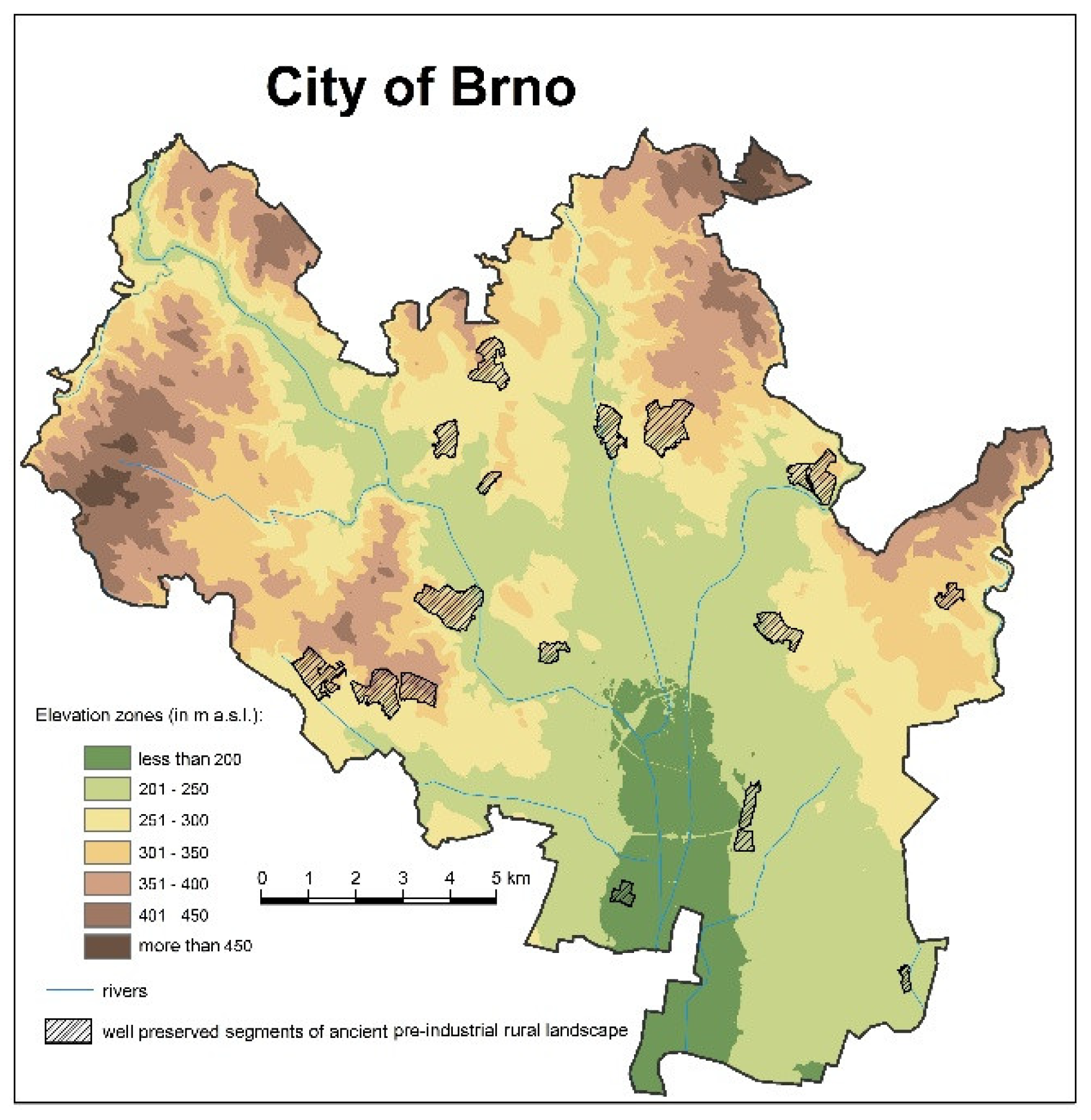
Figure 2.
Territorial growth of Brno and distribution of two groups of pre-industrial rural landscape segments (standard digits—relatively well preserved, italics—heavily degraded).
Figure 2.
Territorial growth of Brno and distribution of two groups of pre-industrial rural landscape segments (standard digits—relatively well preserved, italics—heavily degraded).

Figure 3.
Land use in Brno, 2018 (CORINE LC 2018, simplified, adapted, and supplemented).
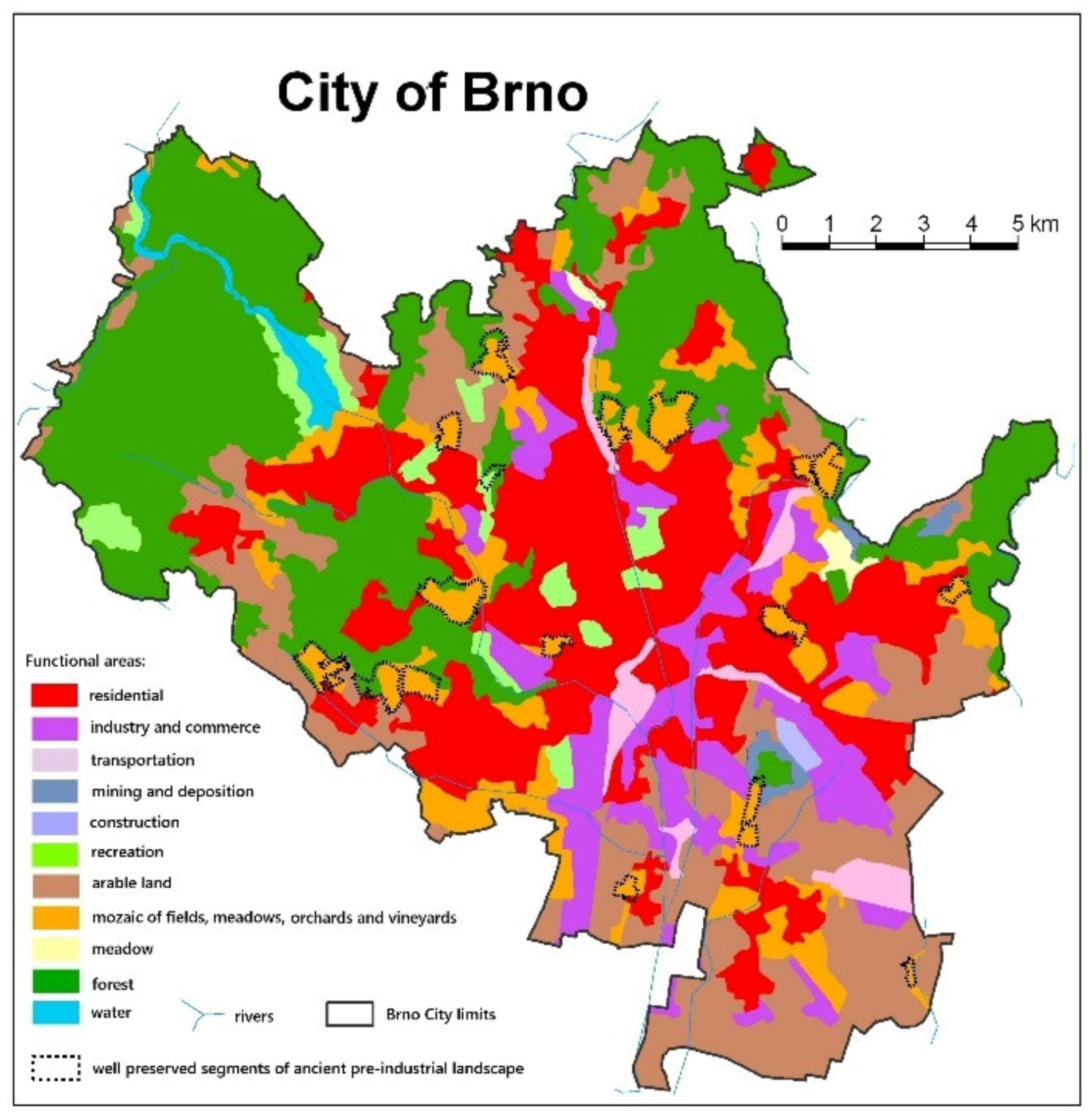
Figure 4.
Schematic procedure of the inventory of old rural cultural landscape remnants applied within Brno.
Figure 4.
Schematic procedure of the inventory of old rural cultural landscape remnants applied within Brno.
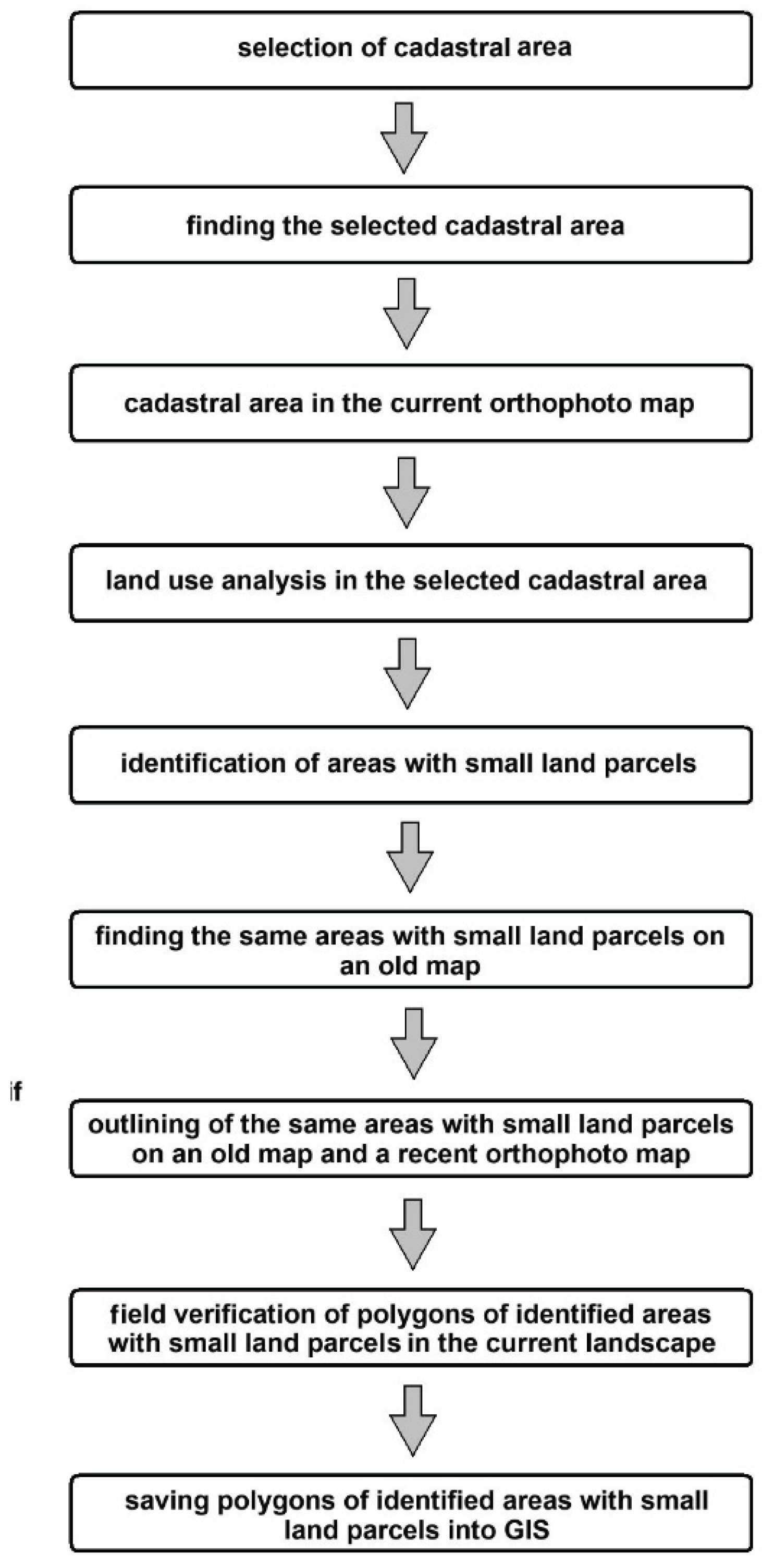
Figure 5.
Location of relatively well-preserved segments of historic rural cultural landscape, with identification of those most threatened by construction activities.
Figure 5.
Location of relatively well-preserved segments of historic rural cultural landscape, with identification of those most threatened by construction activities.

Figure 6.
Climatic regions within the territory of Brno Source: own data processing.
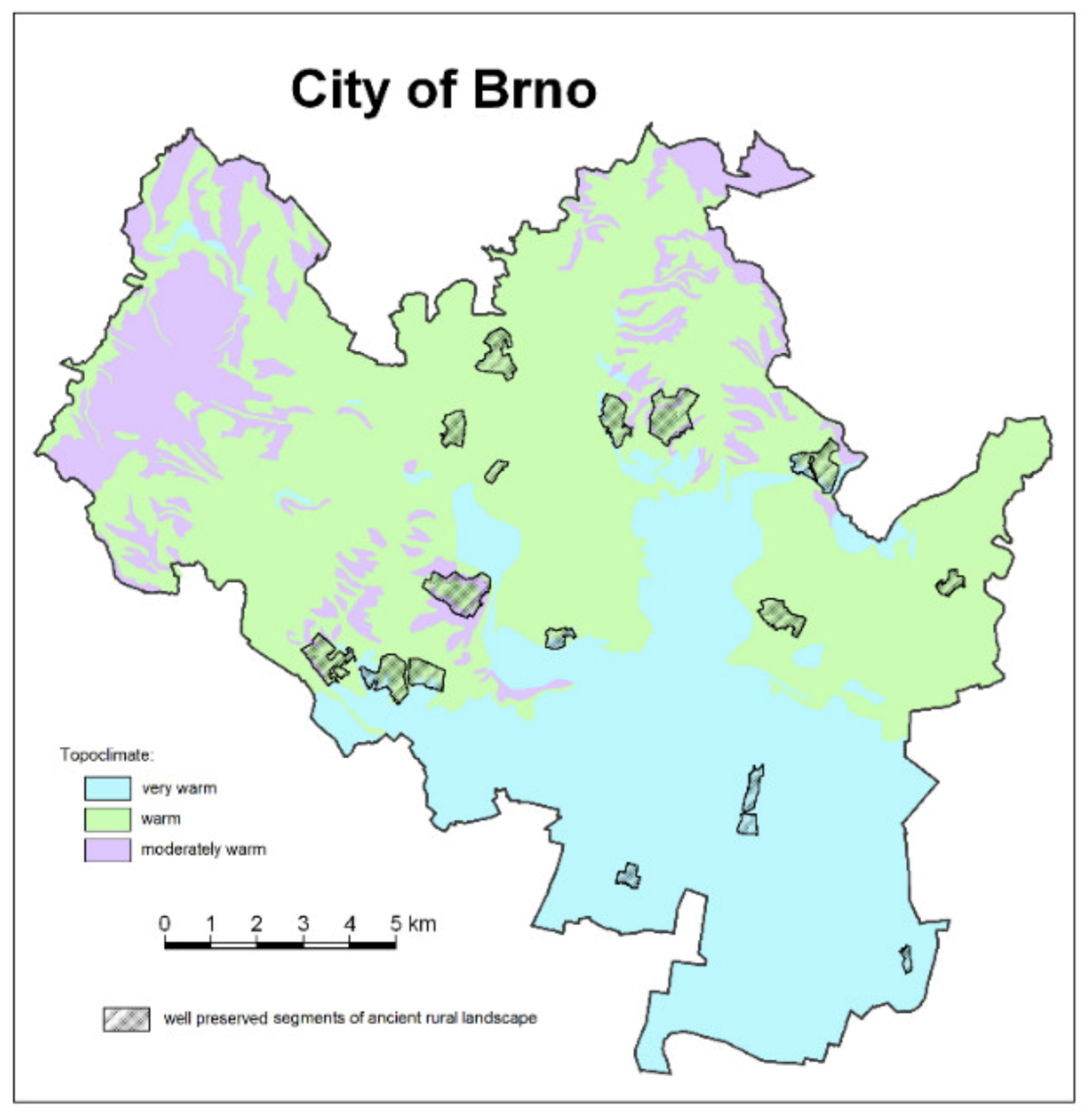
Figure 7.
Staré Brno. Surviving ancient land parcel patterns within dense urban fabric near the medieval core—shown on an orthophoto from 2015 (left) and the cadastral map of 1825. Source: Mapy.cz, www.mza.cz.
Figure 7.
Staré Brno. Surviving ancient land parcel patterns within dense urban fabric near the medieval core—shown on an orthophoto from 2015 (left) and the cadastral map of 1825. Source: Mapy.cz, www.mza.cz.
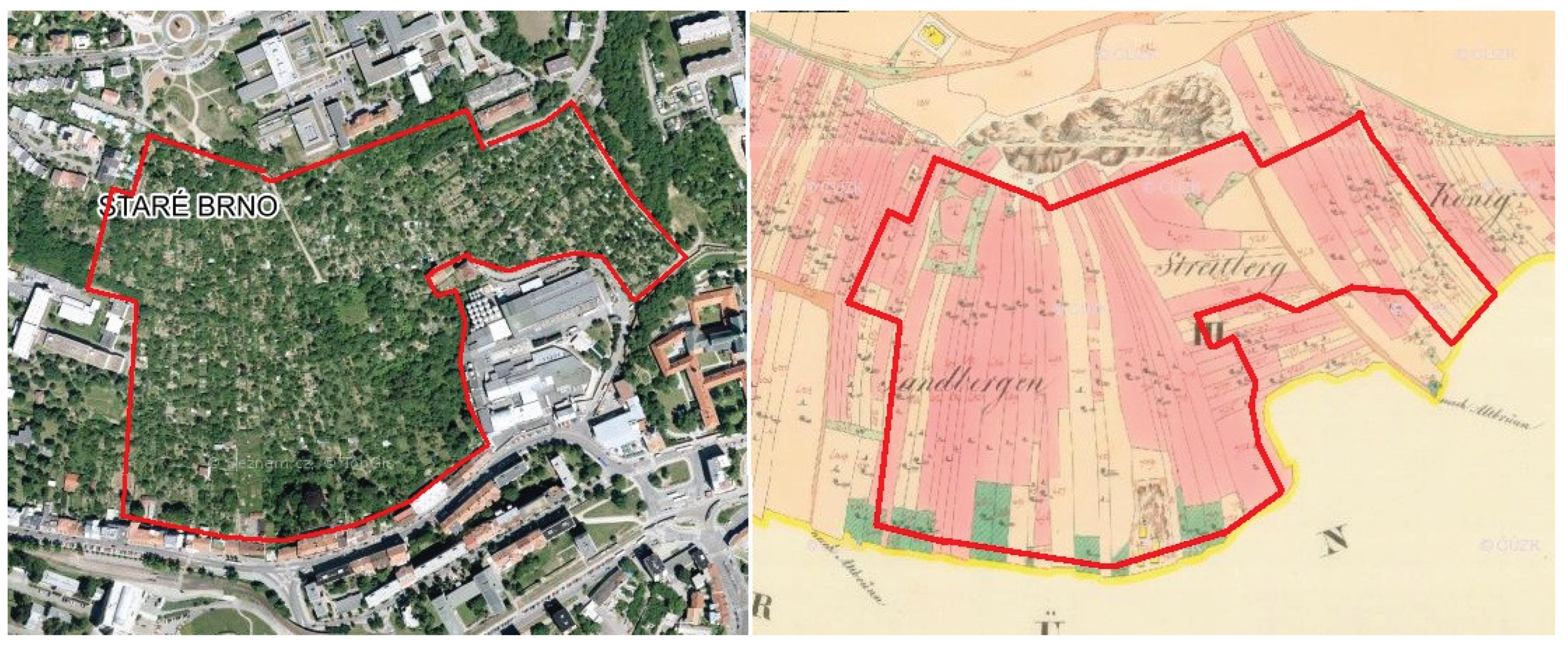
Figure 8.
Židenice–Vinohrady. Segment of rural landscape enclosed within Brno’s peripheral urban fabric, divided by a modern boundary between city districts. Left: orthophoto from 2015; right: cadastral map from 1826. Source: Mapy.cz, www.mza.cz.
Figure 8.
Židenice–Vinohrady. Segment of rural landscape enclosed within Brno’s peripheral urban fabric, divided by a modern boundary between city districts. Left: orthophoto from 2015; right: cadastral map from 1826. Source: Mapy.cz, www.mza.cz.
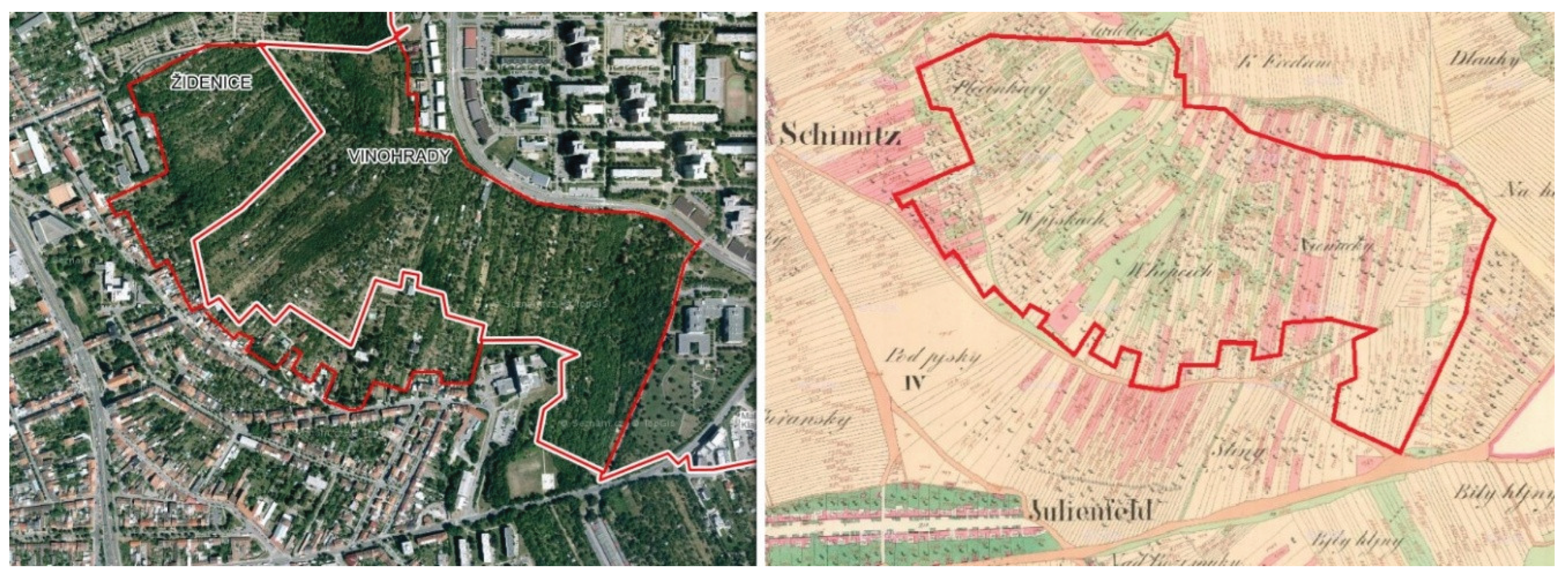

Table 1.
Land use in Brno as of 30 December 2019.
| land use type | area (ha) | % of total |
|---|---|---|
| agricultural land | 7634 | 33.2 |
| -of which gardens) | (2061) | (27.0) |
| forest | 6396 | 27.8 |
| water bodies | 452 | 1.9 |
| built-up areas | 2111 | 9.2 |
| other land | 6425 | 27.9 |
| total | 23,015 | 100 |
Source: Summary of land resources from the Czech Real Estate Cadastre (ČÚZK), 2020.
Table 2.
Representation of natural landscape units, occurrence of segments of old rural cultural landscape in them and their relationship to the limiting roles of forest and development in the territory of the city of Brno.
Table 2.
Representation of natural landscape units, occurrence of segments of old rural cultural landscape in them and their relationship to the limiting roles of forest and development in the territory of the city of Brno.
| No. | Natural environment class | NEC share within Brno City area (in %) |
ALS share in NEC (in %) |
Forest share within NEC (in %) as limiting factor | Development share within NEC (in %) as endangering factor—location preference |
|---|---|---|---|---|---|
| 1 | loess plateaus with luvisols and chernozems | 18.19 | 8.39 | 1.03 | 42.77 |
| 2 | granite plateaus with cambisols | 2.84 | 2.43 | 55.90 | 19.95 |
| 3 | sandstone plateaus with cambisols | 0.10 | 1.03 | 5.64 | 0.00 |
| 4 | plateaus on metabasic rocks with cambisols | 0.43 | 0.02 | 18.35 | 60.00 |
| 5 | plateaus on Neogene deposits with luvisols and chernozems | 2.53 | 2.44 | 0.00 | 15.63 |
| 6 | limestone plateaus with rendzic leptosols | 0.87 | 0.00 | 52.10 | 1.89 |
| 7 | gentle slopes on Devonian conglomerates with cambisols | 0.20 | 0.77 | 0.00 | 60.82 |
| 8 | gentle slopes on loess with luvisols and chernozems | 17.02 | 16.09 | 13.21 | 44.73 |
| 9 | gentle slopes on Neogene deposits with luvisols and chernozems | 2.37 | 1.66 | 9.08 | 24.17 |
| 10 | gentle limestones slopes on with rendzic leptosols | 0.63 | 0.00 | 66.59 | 0.25 |
| 11 | gentle granite slopes on granite with cambisols | 14.01 | 17.00 | 70.07 | 11.17 |
| 12 | gentle sandstone slopes with cambisols | 0.64 | 1.11 | 55.50 | 2.09 |
| 13 | gentle slopes on metabasic rocks with cambisols | 3.70 | 20.02 | 54.99 | 16.60 |
| 14 | fluvial sandy terraces with arenosols and chernozems | 7.16 | 0.70 | 2.40 | 15.53 |
| 15 | steep limestone slopes with rendzic leptosols | 0.66 | 0.00 | 84.04 | 1.14 |
| 16 | steep slopes on Devonian conglomerates with cambisols | 0.09 | 0.00 | 24.92 | 43.68 |
| 17 | steep loess slopes with luvisols and chernozems | 0.33 | 1.41 | 32.97 | 12.79 |
| 18 | steep slopes on Neogene deposits with luvisols and chernozems | 0.15 | 1.08 | 29.39 | 14.73 |
| 19 | steep sandstone slopes with haplic leptosols and cambisols | 0.51 | 0.03 | 82.64 | 0.37 |
| 20 | steep granite slopes with haplic leptosols and cambisols | 10.47 | 18.40 | 82.42 | 3.62 |
| 21 | steep slopes on metabasite rocks with haplic leptosols and cambisols | 1.42 | 5.16 | 75.09 | 11.67 |
| 22 | alluvial plains with fluvisols and gleyic chernozems | 15.65 | 2.27 | 10.13 | 24.67 |
| ∑ | total | 100.00 | 100.00 |
Explanations: natural environment classes (NEC), ancient landscape segment (ALS), solid thick outlining (widely extensive preferred environment type for abundant ALS conservation), dashed thick outlining (widely extensive environment type widely used for development limits the occurrence of ALS), dashed thin outlining (widely insignificant environment type favorable for the occurrence of ALS). Source: own data processing
Table 3.
Recorded relatively well-preserved segments of old rural landscape within the City of Brno and their current threats.
Table 3.
Recorded relatively well-preserved segments of old rural landscape within the City of Brno and their current threats.
| No. | Well preserved (size/quality class) | Threats |
|---|---|---|
| 1 | Bosonohy_1 (B/2) | Reduction of arable land, forest encroachment, cottage development, residential construction |
| 2 | Bosonohy_2 (B/3) | Removal of arable land, forest encroachment, cottage development, suburban housing growth, residential construction |
| 3 | Brněnské Ivanovice (A/2) | Reduction of arable land, overgrowth by woody vegetation, cottage development |
| 4 | Černovice (A/3) | Removal of arable land, overgrowth by woody vegetation, cottage development |
| 5 | Dvorska (A/2) | Reduction of arable land, overgrowth by woody vegetation, cottage development, expansion of built-up area |
| 6 | Kohoutovice (B/3) | Removal of arable land, penetration of residential development, cottage development |
| 7 | Komín (B/3) | Reduction of arable land, cottage development, invasion of residential housing |
| 8 | Královo Pole (A/3) | Removal of arable land, overgrowth by woody vegetation, invasion of residential housing |
| 9 | Líšeň_1 (A/2) | Reduction of forest and arable land strips, renewed overgrowth by woody vegetation, parcel amalgamation, cottage development, expansion of residential housing |
| 10 | Medlánky-Řečkovice (A/3) | Reduction of arable land, parcel amalgamation, cottage development, expansion of residential housing, apartment construction |
| 11 | Nový Lískovec (A/3) | Removal of arable land, overgrowth by woody vegetation; in the upper part expansion of residential and cottage housing, in the lower part apartment construction |
| 12 | Obřany (B/3) | Removal of arable land, overgrowth by woody vegetation, cottage development |
| 13 | Přízřenice (A/2) | Reduction of arable land, expansion of residential housing, commercial and industrial construction |
| 14 | Sadová (B/3) | Removal of arable land, overgrowth by woody vegetation, cottage development |
| 15 | Staré Brno (A/3) | Removal of arable land, overgrowth by woody vegetation, expansion of residential and cottage housing |
| 16 | Žabovřesky (A/3) | Removal of arable land, overgrowth by woody vegetation, cottage development |
| 17 | Židenice (A/3) | Reduction of arable land, forest encroachment, cottage development, residential construction |
Source: own data processing.
Table 4.
Severely degraded segments of pre-industrial old rural cultural landscape within the City of Brno and causes of their degradation.
Table 4.
Severely degraded segments of pre-industrial old rural cultural landscape within the City of Brno and causes of their degradation.
| No. | Severely damaged (quality class “X”) |
Destruction factors |
|---|---|---|
| 1 | Bohunice-Pisárky | extreme fragmentation of parcels many garden cottages |
| 2 | Bystrc NW | extreme fragmentation of parcels many clusters of garden cottages |
| 3 | Bystrc E | dense residential development |
| 4 | Černovice S | extreme fragmentation of parcels many garden cottages, many abandoned parcels |
| 5 | Horní Heršpice | extreme fragmentation of parcels, many garden cottages |
| 6 | Chrlice E | parcels heavily combined |
| 7 | Líšeň N | paddocks, fragmentation of parcels, residential development |
| 8 | Líšeň W | extreme fragmentation of parcels many garden cottages |
| 9 | Maloměřice NE | parcels heavily combined |
| 10 | Maloměřice SE | extreme fragmentation of parcels, area split by trolleybus route, many garden cottages |
| 11 | Mokrá Hora | paddocks, extreme fragmentation of parcels |
| 12 | Obřany W | extreme fragmentation of parcels many garden cottages |
| 13 | Přízřenice-Dolní Heršpice | extreme fragmentation of parcels many garden cottages |
| 14 | Soběšice | extreme fragmentation of parcels, residential development |
| 15 | Štýřice | extreme fragmentation of parcels many garden cottages |
| 16 | Tuřany | mostly paddocks, large plots with islands of different owners |
| 17 | Žebětín | residential development, extreme fragmentation of parcels many garden cottages, ornamental gardens |
Source: own data processing.
Table 5.
Conversion of non-forest rural landscape following incorporation into the City of Brno.
| No. | Type of Original Rural Land (Excluding Forests) | Classes of Visual Transformation of Rural Space within the City | ||
|---|---|---|---|---|
| partial | deep | total | ||
| 1. | Original village cores | Retention of single-storey rural character | Isolated multi-storey construction | Only the street floor plan has been preserved after the complete reconstruction of the buildings |
| 2. | Private plots of smallholders | Some retained by small-scale builders or owners | Re-parcelled and built by developers for housing | Meadows merged for industrial development |
| 3. | Public (municipal) lands | Re-parcelled for small-scale builders, users and owners | Re-parcelled and built by developers for housing | Re-parcelled for industrial, service and transport development |
| 4. | Properties of large landowners and users | Re-parcelled for small-scale builders, users and owners | Re-parcelled and built by developers for housing | Re-parcelled for industrial, service and transport development |
Source: Author’s qualified estimate; precise statistics will be the outcome of further research.
Disclaimer/Publisher’s Note: The statements, opinions and data contained in all publications are solely those of the individual author(s) and contributor(s) and not of MDPI and/or the editor(s). MDPI and/or the editor(s) disclaim responsibility for any injury to people or property resulting from any ideas, methods, instructions or products referred to in the content. |
© 2025 by the authors. Licensee MDPI, Basel, Switzerland. This article is an open access article distributed under the terms and conditions of the Creative Commons Attribution (CC BY) license (http://creativecommons.org/licenses/by/4.0/).
Copyright: This open access article is published under a Creative Commons CC BY 4.0 license, which permit the free download, distribution, and reuse, provided that the author and preprint are cited in any reuse.


