Submitted:
05 November 2025
Posted:
05 November 2025
You are already at the latest version
Abstract
Water is fundamental to the economy of Pakistan, and to many of the county’s 250 million people. Increasing groundwater use in Pakistan is occurring against a backdrop of climate change, dwindling surface water, and human population growth. Historically there has been little groundwater resource management in the country, and that little has mainly related to its use, that is to demand side management. There is some potential for Managed Aquifer Recharge (MAR) to contribute to groundwater supplies, that is, to supply side management. MAR is a complex process which to be effective requires consideration of social, institutional, environmental, technical, financial, and economic parameters. This paper introduces a methodology that has been developed to assess and sum the effect of multiple parameters into single numerical value, to enable the feasibility of proposed MAR projects; the “Managed Aquifer Recharge Feasibility Index (MARFI)”. MARFI was developed using a case study of an MAR project currently being implemented by the Punjab Irrigation Department in the bed of Old Mailsi Canal. MARFI is a suitable tool for examining the pre-project feasibility of any MAR scheme for contributing to wise investment decision making.
Keywords:
1. Introduction
2. Methods
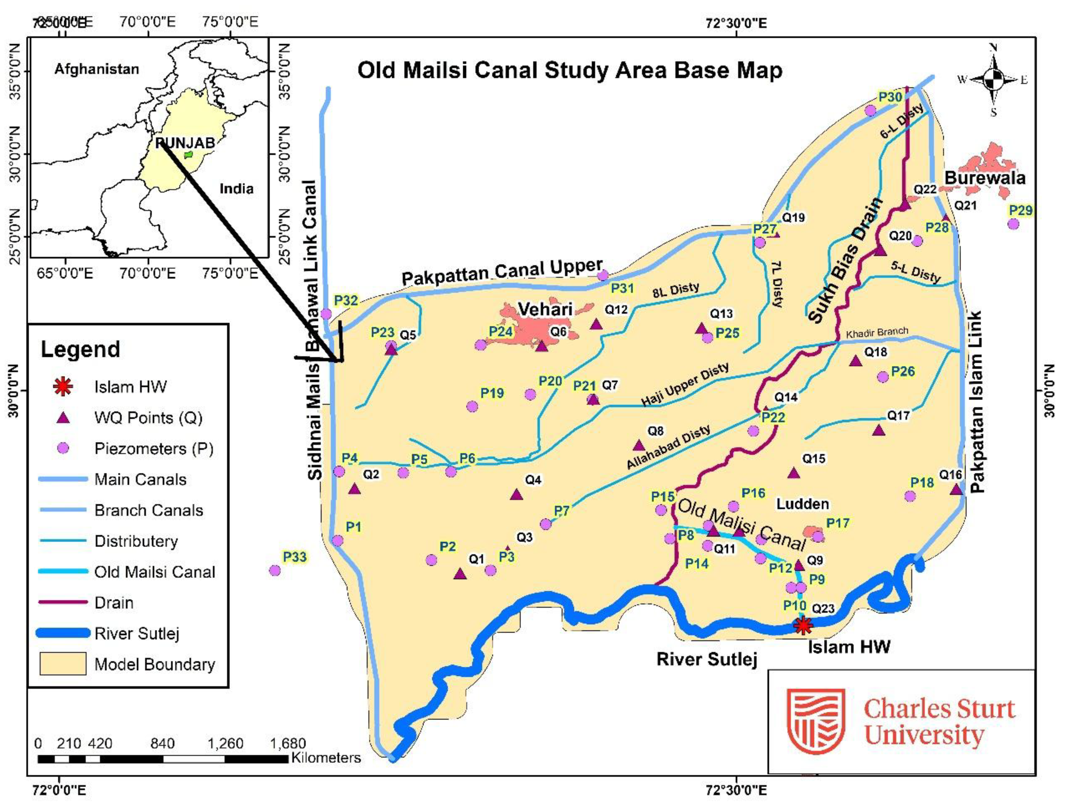
2.1. Study Site
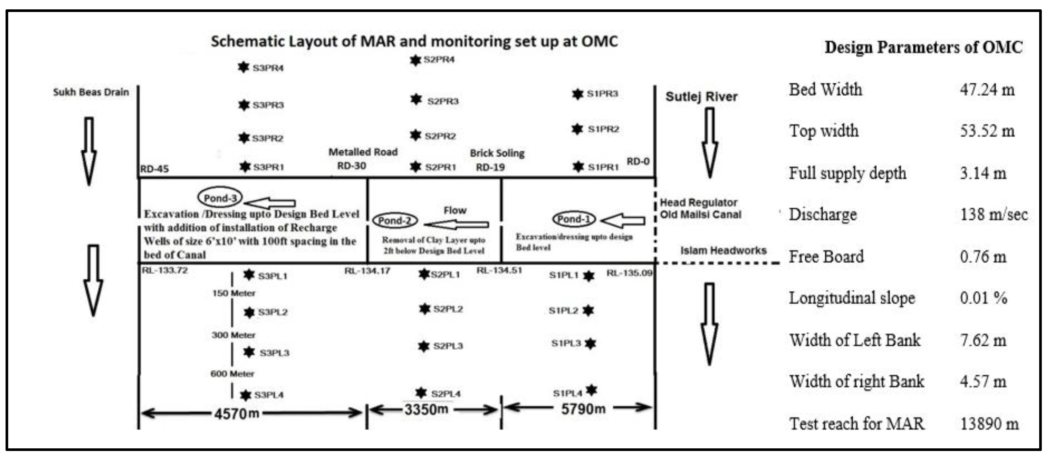
2.2. Experimental Layout of MAR Site
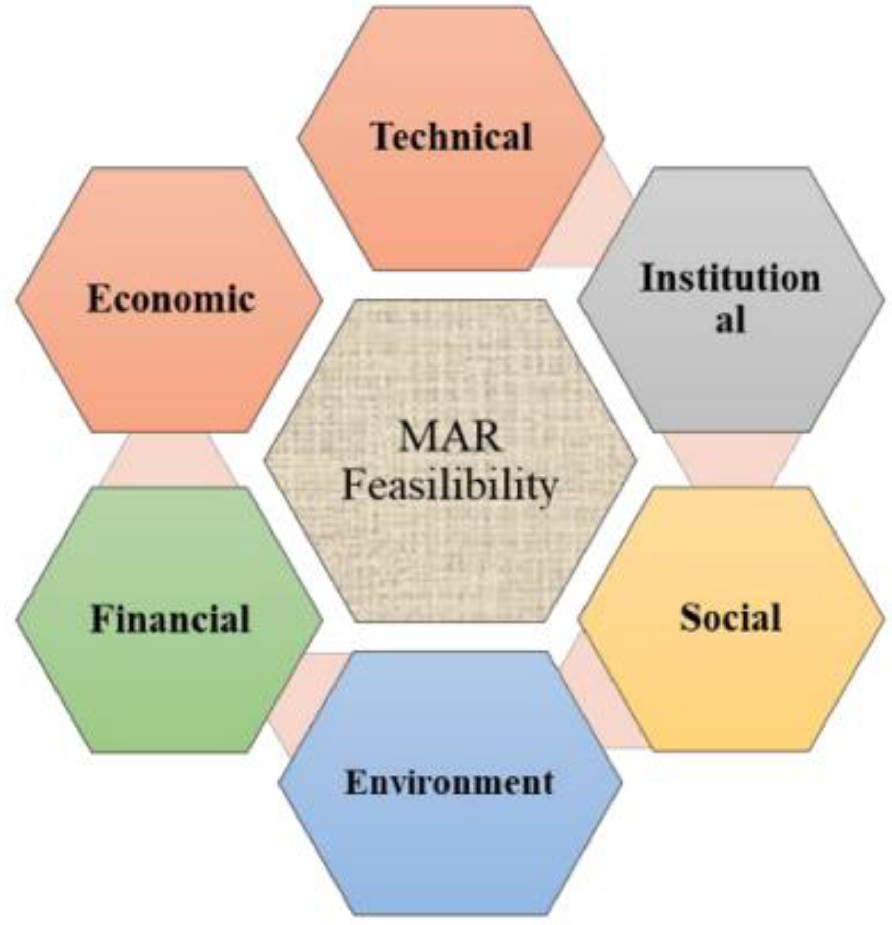
2.3. Developing MARFI
Technical/Physical Parameters
Social Considerations
Economic Feasibility
Financial Analysis
Environmental Aspects
Institutional Arrangements
2.4. The Design of MARFI
3. Results and Discussions
4. Conclusions and Recommendations
Data Availability Statement
Acknowledgments
Conflicts of Interest
Note
References
- Ahirwar, S., M. S. Malik, R. Ahirwar, and J. P. Shukla. 2020. Identification of suitable sites and structures for artificial groundwater recharge for sustainable groundwater resource development and management. Groundwater for Sustainable Development 11, 100388. [Google Scholar] [CrossRef]
- Arshad, M., J. Guillaume, and A. Ross. 2014. Assessing the Feasibility of Managed Aquifer Recharge for Irrigation under Uncertainty. Water 6, 9: 2748–2769. [Google Scholar] [CrossRef]
- Ashraf, M. 2022. Delineating Climatic Causes of Floods 2022: The Way Forward. Hilal. Available online: https://www.hilal.gov.pk/eng-article/detail/NjY1MA==.html.
- Becker, H. A. 2001. Social impact assessment. European Journal of Operational Research 128, 2: 311–321. [Google Scholar] [CrossRef]
- Bhatti, M. T., A. A. Anwar, and M. Aslam. 2017. Groundwater monitoring and management: Status and options in Pakistan. Computers and Electronics in Agriculture 135, 143–153. [Google Scholar] [CrossRef]
- Dashora, Y., P. Dillon, B. Maheshwari, P. Soni, H. K. Mittal, R. Dashora, and P. Katara. 2019. Hydrologic and cost benefit analysis at local scale of streambed recharge structures in Rajasthan (India) and their value for securing irrigation water supplies. Hydrogeology journal 27, 6: 1889–1909. [Google Scholar] [CrossRef]
- Diedhou, M., S. Ndoye, H. Celle, S. Faye, S. Wohnlichs, and P. Le Coustumer. 2023. Hydrogeochemical Appraisal of Groundwater Quality and Its Suitability for Drinking and Irrigation Purposes in the West Central Senegal. Preprints, 2023020013. [Google Scholar] [CrossRef]
- Dillon, P., P. Stuyfzand, T. Grischek, M. Lluria, R. D. G. Pyne, R. C. Jain, and M. Sapiano. 2018. Sixty years of global progress in managed aquifer recharge. Hydrogeology journal 27, 1: 1–30. [Google Scholar] [CrossRef]
- El Moneam, M. A. 2022. Review of artificial recharge prospects for augmentation of groundwater in Egypt: A case study of El Bustan extension area. Ain Shams Engineering Journal. [Google Scholar] [CrossRef]
- Fatima, S., I. Hussain, A. Rasool, T. Xiao, and A. Farooqi. 2018. Comparison of two alluvial aquifers shows the probable role of river sediments on the release of arsenic in the groundwater of district Vehari, Punjab, Pakistan. Environmental Earth Sciences 77, 10. [Google Scholar] [CrossRef]
- Gehman, J., L. M. Lefsrud, and S. Fast. 2017. Social license to operate: Legitimacy by another name? Canadian Public Administration 60, 2: 293–317. [Google Scholar] [CrossRef]
- Giordano, M. 2009. Global Groundwater? Issues and Solutions. Annual Review of Environment and Resources 34, 1: 153–178. [Google Scholar] [CrossRef]
- Glaude, R., N. Simon, P. Orban, and S. Brouyère. 2023. Chemical characterization of urban waters aimed for managed aquifer recharge in the Hesbaye chalk aquifer (Liège, Belgium). EGU General Assembly 2023, Vienna, Austria, 24–28 April. EGU23-2642. [Google Scholar] [CrossRef]
- GoP. 2018a. National Water Policy 2018: Ministry of Water Resources, Government of Pakistan. Islamabad: Available online: https://mowr.gov.pk/SiteImage/Misc/files/National%20Water%20Policy.pdf.
- GOP. 2018b. Pakistan Bureu of Statisctics, Governmnet of Pakistan. Available online: www.pbs.gov.pk/.
- GoP_BoS. 2019. Vehari district at a glance: Pakistan Bureu of Statistiics, Govt of the Pakistan. Islamabd, Pakistan. [Google Scholar]
- GoP_EPA. 1997. Pakistan Environmental Protection Act (PEPA) 1997. Retrieved from. [Google Scholar]
- GoPb_P, D. 2009. Multiple Indicator Cluster Survey (MICS) Punjab 2007-8, Volume 25-District Vehari. Planning and Dvelopment Deptt, Bureu of Statistics, Govt of the Punjab, Lahore, Pakistan.
- GoPb_PID. 2018. Punjab Water Policy; December 2018: Irrigation Department, Govt of the Punjab, Lahore, Pakistan. Available online: https://irrigation.punjab.gov.pk/.
- Govt of Australia. 2008. The feasibility of managed aquifer recharge (MAR) for agriculture: Waterlines Occasional Paper, National Water Commission, Govt of Australia, Retrieved from.
- Halytsia, O., M. Vrachioli, K. Janik, S. Sitek, G. Wojtal, A. Imig, and J. Sauer. 2022. Assessing Economic Feasibility of Managed Aquifer Recharge Schemes: Evidence from Cost-benefit Analysis in Poland. Water Resources Management. [Google Scholar] [CrossRef]
- Hassan, G. Z., G. Shabir, and F. R. Hassan. 2016. Groundwater management through artificial recharge - a potential for jobs: pp 87-108, on World Water Day. Pakistan Engineering Congress, Lahore, Pakistan. [Google Scholar]
- IRI. 2009. Research Studies on Artificial Recharges of Aquifer in Punjab: Research Report No IRR-Phy/552, Irrigation Research Institute (IRI) Government of the Punjab, Irrigation Department. Lahore, Pakistan. [Google Scholar]
- IRI. 2015. PC-1 on Recharge of aquifer for groundwater management in Punjab: Irrigation Research Institute (IRI). Punjab Irrigation Deptt: Lahore, Pakistan. [Google Scholar]
- IRI. Recharge of aquifer for groundwater management in Punjab (2016-2019): Report No IRR-GWMC/121, Groundwater Management Cell, Irrigation Reserach Institute (IRI), Irrigation Department, Lahore, Pakistan. Retrieved from.
- IRI. 2023. Sedimnet study at Islam Headworks: IRI Report No. IRI/Phy/SM/167 March 2023.
- Khair, S., M. Ashfaq, A. Ali, S. Akhtar, T. Mangan, and C. Allan. 2021. Participatory Rural Appraisal: starting the co-inquiry into groundwater and livelihoods: Report No 148, Institute for Land Water and Society, Charles Sturt University, Albury, NSW 2640, Australia. Available online: https://www.csu.edu.au/research/ilws/publications/ilws-reports/2021-reports/PRA-ACIAR-Report-148.pdf https://www.csu.edu.au/research/ilws/publications/ilws-reports/2021-reports/PRA-ACIAR-Report-148.pdf.
- Khalid, S., M. Shahid, Natasha, A. H. Shah, F. Saeed, M. Ali, and C. Dumat. 2020. Heavy metal contamination and exposure risk assessment via drinking groundwater in Vehari, Pakistan. Environ Sci Pollut Res Int 27, 32: 39852–39864. [Google Scholar] [CrossRef] [PubMed]
- Madhavan, S., S. R. Kolanuvada, V. Sampath, P. D. Roy, P. Moorthy, L. Natarajan, and L. Chokkalingam. 2023. Assessment of groundwater vulnerability using water quality index and solute transport model in Poiney sub-basin of south India. Environ Monit Assess 195, 2: 272. [Google Scholar] [CrossRef]
- Maheshwari, B. 2023. Edited by H. Ojha and et al. Managing the Invisible Under Changing Climate: A Participatory Approach for Sustaining Groundwater Use. In Climate Risks to Water Security; Palgrave Studies in Climate Resilient Societies. Springer International Publishing: pp. 61–87. [Google Scholar] [CrossRef]
- Maliva, R. 2014. Economics of Managed Aquifer Recharge. Water 6, 5: 1257–1279. [Google Scholar] [CrossRef]
- Mitchell, M., C. Allan, J. F. Punthakey, C. M. Finlayson, and M. R. Khan. 2021. Edited by M. A. Watto, M. Mitchell and S. Bashir. Improving water management in Pakistan using social-ecological systems research. In Water resources of Pakistan: Issues and impacts. Cham: Springer: pp. 249–271. [Google Scholar] [CrossRef]
- Mondal, M., G. S. Bhunia, and P. K. Shit. 2012. Vulnerability analysis of embankment breaching – a case study of Moyna drainage basin in Purba Medinipur West Bengal India. International Journal of Geology, Earth and Environmental Sciences 2, 3: 89–102. [Google Scholar]
- Mukherji, A., and T. Shah. 2005. Groundwater socio-ecology and governance: a review of institutions and policies in selected countries. Hydrogeology journal 13, 1: 328–345. [Google Scholar] [CrossRef]
- Muzammil, M., A. Zahid, and L. Breuer. 2020. Water Resources Management Strategies for Irrigated Agriculture in the Indus Basin of Pakistan. Water 12, 1429. [Google Scholar] [CrossRef]
- Noshin, S., M. Alam, S. Sadiq, and S. J. Mandokhail. 2018. Stability Analysis of Flood Bunds: A Study on Geotechnical Health Evaluation of Embankments. IOP Conf. Ser.: Mater. Sci. Eng. 414, 012035. [Google Scholar] [CrossRef]
- Pahl-Wostl, C., C. Vörösmarty, A. Bhaduri, J. Bogardi, J. Rockström, and J. Alcamo. 2013. Towards a sustainable water future: shaping the next decade of global water research. Current Opinion in Environmental Sustainability. [Google Scholar]
- Punthakey, J. F., M. Khan, R. Niaz Ahmad, M. Riaz, M. Javed, G. Z. Hassan, and J. Blackwell. 2016. Optimising canal and groundwater management to assist water user associations in maximizing crop production and managing salinisation in Australia and Pakistan: Australian Centre for International Agricultural Research (ACIAR); Research Out put. In Charles Sturt University, Australia. Retrieved from. [Google Scholar]
- Qureshi, A. S. 2015. Improving food security and livelihood resilience through groundwater management in Pakistan. Global Advanced Research Journal of Agricultural Science: Vol. 4, 10, pp. 687–710. Available online: http://garj.org/garjas/home.
- Qureshi, A. S. 2018. Edited by A. Mukherjee. Challenges and Opportunities of Groundwater Management in Pakistan. In Groundwater of South Asia. pp. 735–757. [Google Scholar]
- Qureshi, R. H., and M. Ashraf. 2019. Water security issues of agriculture in Pakistan: Pakistan Academy of Sciences (PAS). Islamabad, Pakistan: pp. 41., pp. 41. [Google Scholar]
- Reinecke, R., A. Wachholz, S. Mehl, L. Foglia, C. Niemann, and P. Doll. 2020. Importance of Spatial Resolution in Global Groundwater Modeling. Ground Water 58, 3: 363–376. [Google Scholar] [CrossRef]
- RockstrÖm, J., W. Steffen, K. Noone, Å. Persson, S. F. Chapin, E. F. Lambin, and U. Svedin. 2009. A safe operating space for humanity. Nature Vol 461. [Google Scholar] [CrossRef] [PubMed]
- Sindhu, A. S. 2010. District Vehari: Hazard, vulnerability and development profile. : Rural Development Policy Institute (RDPI): Islamabad, Pakistan. [Google Scholar]
- Singh, L. K., M. K. Jha, and V. M. Chowdary. 2017. Multi-criteria analysis and GIS modeling for identifying prospective water harvesting and artificial recharge sites for sustainable water supply. Journal of Cleaner Production 142, 1436–1456. [Google Scholar] [CrossRef]
- Tiwari, S., and B. K. Yadav. 2023. Edited by M. Sherif, V. P. Singh, A. Sefelnasr and M. Abrar. Factors Influencing the Site Selection Criteria for Efficient Aquifer Storage and Recovery (ASR) System in Saline Regions. In Water Resources Management and Sustainability: Solutions for Arid Regions. Cham: Springer Nature Switzerland: pp. 219–229. [Google Scholar]
- Ulibarri, N., N. Escobedo Garcia, R. L. Nelson, A. E. Cravens, and R. J. McCarty. 2021. Assessing the Feasibility of Managed Aquifer Recharge in California. Water Resources Research 57, 3: e2020WR029292. [Google Scholar] [CrossRef]
- Vaddadi, N., C. Vansarochana, and V. Raghavan. 2023. Identification of Potential Groundwater Recharge Zones Using GIS Based Multi-Criteria and AHP Technique: A Case Study of Pune City, Western Maharashtra. Environment and Natural Resources Journal 21, 3: 1–13. [Google Scholar] [CrossRef]
- WAPDA. 2009. Feasibility report for underground storage of flood water: Water and Power Development Authority (WAPDA), Lahore, Pakistan. Retrieved from. [Google Scholar]
- Watto, M. A., and A. W. Mugera. 2016. Groundwater depletion in the Indus Plains of Pakistan: imperatives, repercussions and management issues. International Journal of River Basin Management 14, 4: 447–458. [Google Scholar] [CrossRef]
- WB. 1962. Indus Waters Treaty 1960-An agrement between India and Pakistan: United Nations-Treat Series No 6030: The World Bank Retrieved from. Available online: https://www.worldbank.org/en/region/sar/brief/fact-sheet-the-indus-waters-treaty-1960-and-the-world-bank.
- WB. 2019. Opportunities-for-a-Clean-and-Green-Pakistan-A Country Environmental-Analysis: The World Bank, Washington DC 20433. Retrieved from. [Google Scholar]
- WMO. 2007. Economic Aspects of Integrated Flood Management: World Meteorological Organization, Switzerland. Available online: https://www.floodmanagement.info/floodmanagement/wp-content/uploads/2020/06/Economic_Aspects_of_IFM_En.pdf.
- Zakir-Hassan, G. 2023. Improving Sustainable Groundwater Management: A Case Study of Managed Aquifer Recharge in Punjab Pakistan. PhD thesis, 2023, School of Agricultural, Environmental, and Veterinary Sciences Charles Sturt University, Australia. [Google Scholar]
- Zakir-Hassan, G., S. Akhtar, J. F. Punthakey, and G. Shabir. 2022. Assessnment of groundwater potential and threats for its sustainable use, case study of Greater Thal Canal area from Punjab Pakistan. Water Productivity Journal 2, 4: 53–71. [Google Scholar] [CrossRef]
- Zakir-Hassan, G., C. Allan, J. F. Punthakey, L. Baumgartner, and M. Ahmad. 2023. Edited by M. Ahmad. Groundwater Governance in Pakistan: An Emerging Challenge. In Water Policy in Pakistan: Issues and Options. Cham: Springer International Publishing: pp. 143–180. [Google Scholar]
- Zakir-Hassan, G., L. Baumgartner, C. Allan, J. F. Punthakey, and H. Rasheed. 2025. Risk Assessment of Heavy Metals in Groundwater for a Managed Aquifer Recharge Project. Water 17, 21. [Google Scholar] [CrossRef]
- Zakir-Hassan, G., A. Hassan, and G. Shabir. 2022. Evaluation of Impact of Soil Properties on Strength of Flood Levees in Indus River Basin of Pakistan. Australian Journal of Engineering and Innovative Technology 4, 3: 52–64. [Google Scholar] [CrossRef]
- Zakir-Hassan, G., J. F. Punthakey, C. Allan, and L. Baumgartner. 2025. Integrating Groundwater Modelling for Optimized Managed Aquifer Recharge Strategies. Water 17, 14. [Google Scholar] [CrossRef]
- Zakir-Hassan, G., J. F. Punthakey, G. Shabir, and F. R. Hassan. 2024. Assessing the potential of underground storage of flood water: A case study from Southern Punjab Region in Pakistan. Journal of Groundwater Science and Engineering 12, 4: 387–396. [Google Scholar] [CrossRef]
- Zakir-Hassan, G., G. Shabir, and S. Akhtar. 2023. Precision Agriculture and Groundwater- Challenges and Options for Sustainability in Indus Basin of Pakistan. Paper presented at the Internnational Conference on Precision and Sustainable Agriculture under Climate change, (IPSAC-2023), Khawja Fareed University of Engineering and Information Technology; Rahim Yar Khan Pakistan. [Google Scholar]
- Zakir-Hassan, G., G. Shabir, F. R. Hassan, and S. Akhtar. 2022. Groundwater-food security nexus under changing climate-historical prospective of Indus basin irrigation system in Pakistan. Int. J. Social Science Humanities Research 5, 10: 28–38. [Google Scholar] [CrossRef]
- Zakir-Hassan, G., G. Shabir, F. Yasmeen, and F. R. Hassan. 2025. Assessment of Groundwater quality- A case study of a groundwater recharge project in Vehari Pakistan. ICON Journal of Engineering Applications of Artificial Intelligence 1, 3: 27–38. [Google Scholar]
- Zakir-Hassan, G., G. Shabir, F. Yasmin, and M. A. Ghaffar. 2022. Environmental challenges for groundwater-irrigated agriculture in Punjab Pakistan. Paper presented at the International Conference on Recent Trends in Environmental Sustainability, 21-23 February. [Google Scholar]


| MARFI Value | Class of MAR |
|---|---|
| 400-500 | Highly Feasible |
| 200-400 | Feasible |
| 100-200 | Low feasible |
| 10-100 | Not feasible |
| ID | Factor/parameter (F) with description |
Ranks (R) (Most important-R=5; least important-R =1) |
Weights (W) Maximum = 100 Minimum = 10 |
Weights assigned for OMC MAR project. |
|---|---|---|---|---|
| F1 | Geophysical Conditions (Land slope, topography-flow possible under gravity or required lift, infrastructure, site accessibility) | 4 |
|
90 |
| F2 | Subsurface Lithology/ Soil Texture and structure (Texture -sandy, clayey, silty, mixed; infiltration rate-low or high; structure- well graded or poorly graded) |
4 |
|
80 |
| F3 | Aquifer Parameters/type (Aquifer type, transmissivity, porosity) |
3 |
|
70 |
| F4 | Water Availability (Historic surplus water, quantity, frequency, duration, Source of water rainfall, floodwater, wastewater, seawater) |
5 |
|
90 |
| F5 | Water Recovery (Option for aquifer storage and recovery) |
2 |
|
80 |
| F6 | Suitable Recharge Method (Infiltration, injection, spreading) |
1 |
|
70 |
| F7 | Sediments (Physical and chemical properties like, suspended load in source water, chances of clogging, sediment load, concentration, sediment size, sediment type, turbidity level) |
3 |
|
70 |
| F8 | Underground Storage Potential (How much water can be stored in aquifer) |
5 |
|
100 |
| F9 | Groundwater Depletion Rate (Historical water table depletion trends, annual depletion rates) |
4 |
|
100 |
| F10 | Climatic Conditions (Rainfalls, floods, droughts) |
2 |
|
|
| F11 | Quality of Source Water (Quality of source water to be recharged into the aquifer- chemical, biological, physical) |
4 |
|
90 |
| F12 | Quality of Sink/target Water (What is quality of host water in the aquifer- physical, chemical, and biological quality for different uses) |
4 |
|
80 |
| F13 | Resultant Water Quality (Quality of water in aquifer after recharge- Physical, chemical, biological quality for different uses) |
3 |
|
70 |
| F14 | Environmental Impacts (Rehabilitation of wetlands, groundwater dependent ecosystems, improvement in value of the place, improved landscape, cutting of trees, temperature controlled, new plants, greenery, temperature control, Recreational value addition, EIA, IEE, loss of flora and fauna, improvement of Aesthetic value of place) |
4 |
|
80 |
| F15 | Soil Chemistry (Chemistry of soil /vadose zone through which recharge water will flow before reaching the saturated zone/groundwater. It might be saline, sodic, or good soil. For example, soil pH, Ec) |
3 |
|
80 |
| F16 | Monitoring System for MAR (Monitoring system is in place or not- as no management without monitoring, pre and post monitoring) |
3 |
|
60 |
| F17 | Organizational Capacity (Capacity of agencies for implementation, adequate HRs) |
4 |
|
60 |
| F18 | Policy and Legal Support (Legal aspects including policy, regulatory framework, Laws, Rules, supporting MAR). b |
3 |
|
70 |
| F19 | Social Aspects (Social license, cultural/social considerations, improved livelihood; displacement of people, plants, animals; alternate land for community, livelihood, water is life, business of opportunities, creation of jobs, drinking water for animals,) Increase Crop Production Opportunities for increasing area under high value cash crops. |
4 |
|
90 |
| F20 | Demand for Groundwater (Irrigation, and others- like drinking, livestock, industries, aquaculture) |
3 |
|
90 |
| F21 | Economic Analysis Cost Benefit Analysis (CBA), anticipated returns on the investment (ROI), Economic internal rate of return-EIRR and other parameters, increase in cropped area, more crops, manpower required, economic value of water through MAR0, Contribution to GDP) |
5 |
|
70 |
| F22 | Financial Viability (Cost benefit ratio-CBR, Financial internal rate of return-FIRR, reduction in pumping cost,) |
5 |
|
70 |
| F23 | Site/Land Availability (Land for construction of recharging system, Alternate use of land) |
5 |
|
90 |
| F24 | Funding (Priority of the Govt for funding, funds available or not) |
2 |
|
60 |
| Factor ID | Old Mailsi Canal Ranks (R) | Old Mailsi Weights (W) | R x W |
|---|---|---|---|
| F1 | 4 | 90 | 360 |
| F2 | 4 | 80 | 320 |
| F3 | 3 | 70 | 210 |
| F4 | 5 | 90 | 450 |
| F5 | 2 | 80 | 160 |
| F6 | 1 | 70 | 70 |
| F7 | 3 | 70 | 210 |
| F8 | 5 | 100 | 500 |
| F9 | 4 | 100 | 400 |
| F10 | 2 | 90 | 180 |
| F11 | 4 | 80 | 320 |
| F12 | 4 | 70 | 280 |
| F13 | 3 | 70 | 210 |
| F14 | 4 | 80 | 320 |
| F15 | 3 | 80 | 240 |
| F16 | 3 | 60 | 180 |
| F17 | 4 | 60 | 240 |
| F18 | 3 | 70 | 210 |
| F19 | 4 | 90 | 360 |
| F20 | 3 | 90 | 270 |
| F21 | 5 | 70 | 350 |
| F22 | 5 | 70 | 350 |
| F23 | 5 | 90 | 450 |
| F24 | 2 | 60 | 120 |
| Sum | 6760 | ||
| n = | 24 | ||
| MARFI = | 282 |
Disclaimer/Publisher’s Note: The statements, opinions and data contained in all publications are solely those of the individual author(s) and contributor(s) and not of MDPI and/or the editor(s). MDPI and/or the editor(s) disclaim responsibility for any injury to people or property resulting from any ideas, methods, instructions or products referred to in the content. |
© 2025 by the authors. Licensee MDPI, Basel, Switzerland. This article is an open access article distributed under the terms and conditions of the Creative Commons Attribution (CC BY) license (https://creativecommons.org/licenses/by/4.0/).


