
Submitted:
24 October 2025
Posted:
27 October 2025
You are already at the latest version
Abstract
Forest and land fires are a severe problem in Indonesia, with widespread impacts on the environment, public health, and economy. Early detection is crucial in fire prevention and mitigation efforts to minimize losses. This study proposes a convolutional neural network (CNN)-based forest fire detection system utilizing moderate resolution imaging spectroradiometer (MODIS) satellite data. MODIS imagery is used because of its wide spatial coverage, high temporal resolution, and consistent availability across Indonesia. The research methodology includes extracting hotspot data from MODIS imagery, preprocessing the data to improve their quality, and labelling images based on actual fire events. Furthermore, a CNN is used to classify images into fire and non-fire categories. The CNN model is trained on the preprocessed data, including historical data, and validated using ground truth from official reports on forest fires in Indonesia. The results demonstrate that our CNN-based detection system achieves high accuracy >90% and superior hotspot sensitivity compared with conventional methods. The proposed system improves the effectiveness of early warnings, supports decision making by authorities, and contributes to sustainable forest fire mitigation efforts in Indonesia. Future work will aim to achieve high fire hotspot detection accuracy.
Keywords:
forest fire
; CNN
; detection
; MODIS
; Sumatra Indonesia
1. Introduction
Forest and land fires are among the most pressing environmental challenges facing Indonesia, with Sumatra and Kalimantan being the most severely affected. Each year, these events cause extensive ecosystem damage, loss of biodiversity, and significant economic losses. Smoke from forest fires produces severe air pollution, severely impacting public health and causing diseases, such as acute respiratory infections. Forest fires also contribute significantly to global carbon emissions, intensifying climate change. Therefore, a fast, accurate, and reliable early detection system is required to minimize the impact of forest fires. To date, fire detection methods in Indonesia still rely heavily on manual reports and conventional monitoring, which tend to be slow and ineffective in providing early warnings. Satellite remote sensing technologies such as moderate resolution imaging spectroradiometer (MODIS) have been extensively used to detect fire hotspots because of their advantages in providing imagery data with wide coverage and high temporal resolution. However, processing these satellite data to provide more precise and accessible fire detection information in real time remains challenging.
In Sumatra, forest fires have become prevalent and regularly occur during the summer or dry season, particularly in Riau and South Sumatra. Thousands of hectares are burned because of these fires, causing many floras and fauna to lose their habitats. Both Sumatra and Kalimantan share similar soil characteristics, featuring extensive peatlands that are highly susceptible to burning under dry conditions. Sumatra consists of eight provinces, with Riau and South Sumatra being the regions most affected by fires because of the dominance of peatlands. Riau Province experiences frequent and severe forest fires and is geographically close to Malaysia and Singapore. When fires occur, the wind typically carries smoke across borders, severely affecting these neighboring countries with transboundary air pollution and environmental degradation. Consequently, daily activities such as business, schooling, and public services are typically disrupted or suspended. The CNNs algorithm has been extensively recognized for its effectiveness in data analysis and image processing. Using MODIS satellite data, CNNs can detect and distinguish between burned and unburned areas with high accuracy. The application of CNNs is expected to provide an innovative solution to the current environmental and forest fire challenges, contributing to improved early detection and a cleaner, healthier environment. Figure 1 shows the map of Sumatra Island in Indonesia.
Artificial intelligence (AI) technology, particularly CNNs, provides a potential solution for the automatic detection of forest fires. CNNs are effective in analyzing images and detecting specific patterns, making them highly suitable for classifying fired and unfired areas in satellite imagery. By integrating MODIS satellite data and CNN methods, early detection systems are expected to provide more accurate results, reduce the detection error rate, and increase the speed of information delivery to authorities. With such CNN-based forest fire detection systems, the development of a more effective early warning mechanism is expected, allowing for rapid and targeted fire prevention and response efforts. This study aims not only to develop sophisticated detection technology but also to support disaster mitigation and environmental sustainability policies in Indonesia. The following research questions are raised:
- ▪
- How can MODIS satellite data be optimized for forest fire detection in Sumatra, Indonesia?
- ▪
- How can CNNs be used to improve the accuracy and speed of fire detection?
- ▪
- How can a detection system based on these technologies be integrated with existing fire management frameworks in Indonesia?
By answering these questions, this study is expected to make a significant contribution to improving forest fire early detection. The objective of this study is to develop a CNN-based forest fire detection system using MODIS satellite data, which is capable of detecting hotspots more accurately and efficiently than conventional approaches. Furthermore, this study aims to reduce false alarm rates, increase response times, and support the government and relevant parties in mitigating and combating forest fires. Our system is expected to contribute to environmental monitoring and public health protection
2. Literature Review
Forest and land fires have become a global issue that has received significant attention from various researchers. According to [1], forest fires not only cause ecological damage but also contribute significantly to global carbon emissions, intensifying climate change. In Indonesia, [2] demonstrated that forest fires in Sumatra are triggered by uncontrolled plantation clearing, dry climates, and weak field monitoring. Therefore, early detection efforts are a crucial strategy for mitigating forest fires in tropical regions. Satellite data have long been used in forest fire monitoring. The MODIS sensor installed on the Terra and Aqua satellites provides data with wide coverage and high frequency, making it effective in hotspot detection [3]. According to [4], MODIS-based active fire detection algorithms have been used globally, including in early warning systems such as NASA’s Fire Information for Resource Management System (FIRMS). However, research by [5] emphasized that MODIS data still have limitations, particularly in terms of their relatively low spatial resolution and the possibility of detection errors due to clouds, smoke, or surface reflections.
With the development of AI technology, machine learning (ML) and deep learning (DL) methods have been adopted to improve the accuracy of fire detection. CNNs are an effective DL algorithm for image processing, including satellite imagery. Research by [6,7,8] demonstrated that CNNs recognize fire patterns with higher accuracy than conventional methods because they automatically extract complex features from image data. Research by [9,10,11,12] successfully integrated CNNs with satellite data to detect forest fires in China, resulting in a detection accuracy rate of over 90%. Land and forest fires are triggered by a combination of human factors such as land clearing by burning, conventional agricultural practices, and weak monitoring and environmental conditions, such as prolonged dry seasons and the presence of flammable peatlands [13].
The impacts of these fires extend to ecosystem damage, biodiversity loss, significant carbon emissions, smoke-induced public health problems, and significant economic losses [14]. Numerous studies have emphasized the importance of technology-based monitoring such as remote sensing (MODIS, Sentinel, VIIRS) combined with weather data and ML for early detection and risk prediction, as discussed in [15,16]. In [17,18,19], the researchers highlighted various effective prevention efforts, including community-based management, peat restoration, field patrols, integrated land use policies, and strict law enforcement. Socioeconomic studies have highlighted the need for alternative livelihoods and economic incentives to reduce reliance on land burning [20]. Recent research trends point to the use of big data, the Internet of Things, drones, and AI-based predictive models. However, long-term studies on restoration effectiveness, high-resolution data integration, and cost-benefit analysis of various fire interventions are lacking [21,22,23,24,25].
In Indonesia, research on the use of CNNs in forest fire detection is still relatively limited. Most studies still focus on analyzing MODIS or Landsat satellite imagery using conventional methods such as the normalized difference vegetation index or thresholding. For example, [26,27,28] used MODIS hotspot data to analyze the distribution of forest fires in Sumatra but did not employ a DL approach to improve accuracy. The application of MODIS data-based CNNs to forest fire detection in Indonesia represents a potential breakthrough, providing improvements in both detection speed and accuracy [29]. In this regard, this study integrates MODIS satellite data and CNNs to produce a sophisticated fire detection system. The combination of these two approaches is expected to address the limitations of conventional algorithms and provide solutions more relevant to Indonesia’s geographical and climatic conditions, which are prone to forest fires.
3. Methodology
This research aims to develop and evaluate a CNN-based forest fire detection system. This study was conducted through several stages, beginning with data collection, preprocessing, CNN model design, training, evaluation, and visualization of the results. The methodology combines remote sensing and DL approaches to produce more accurate and reliable fire detection in Sumatra Island, the Indonesian geographic context. The first stage involved data collection from areas in Riau Province, Sumatra, characterized by forest fires. The data collected included daily imagery with relevant spectral channels, such as thermal infrared, mid-infrared, and visible spectra, used to identify heat anomalies and hotspot indications.
Hotspot data from the FIRMS were also used as ground truth in the labeling process to ensure data validity and that imagery free from cloud cover or excessive noise was selected. The process involves passing a small matrix (a kernel) over an image, transforming the image based on the values in the kernel. Subsequent feature map values are calculated using Equation (1), where the input image and kernel are denoted by f and h, respectively. The indices of the rows and columns of the result matrix are marked with m and n, respectively.
To solve both problems, we can pad our image with an additional border. For example, adding a 1-pixel padding to a 6 × 6 image increases its size to 8 × 8. Applying a 3 × 3 filter (kernel) then results in a 6 × 6 output, preserving the original dimensions. This practice leads to two common types of convolutions: “valid” (no padding) and “same” (padding to preserve the input size). The “same” convolution uses a border of padding, ensuring that the input and output dimensions are identical. The required padding width p is padding for a filter size f is defined by Equation (2). Figure 2 illustrates the data processing steps in the CNN algorithm that led to the output of a single neuron.
As shown in Figure 3, a larger convolutional stride results in fewer overlapping receptive fields. When designing the CNN architecture, the stride can be increased to reduce this overlap or the spatial dimensions of the feature map. The dimensions of the resulting matrix, considering the padding and stride parameters, are calculated using Equation (3).
Padding increases the size of the output feature map. Increasing the padding width while keeping the kernel size and stride constant gives more “room” for the convolution operation, resulting in a larger output.
The output size of the convolutional layer can be calculated as in equation (4).
where “2 × Padding” accounts for the padding applied to both the left and right sides of the input; “+ 1” accounts for the initial position of the filter, which starts at the beginning of the padded input.
The second stage was data preprocessing, which included cropping the imagery to suit the research area in Sumatra Island, Indonesia, normalizing pixel values, and creating a dataset with two labels: “fire” and “non-fire.” The resulting data were divided into three groups: 70% training data, 15% validation data, and 15% test data. Furthermore, data augmentation techniques such as rotation, flipping, and contrast adjustment were used to increase the diversity of the training data and reduce the potential for overfitting. The third stage was designing the CNN model. The CNN architecture used consisted of several convolutional layers, a pooling layer, and a fully connected layer. The convolutional layer extracts spatial features from the image, and the pooling layer reduces the data dimensionality to speed up the training process. The fully connected layer was used for the final classification with a Sigmoid activation function to generate probabilities between the fire and non-fire classes. Optimization was performed using the gradient descent optimizer algorithm with a categorical cross-entropy loss function.
The fourth stage was model training and evaluation. In this stage, the CNN model was trained using the preprepared dataset for a specified number of epochs until convergence was achieved. The performance evaluation was performed using metrics such as accuracy, precision, recall, and F1-score. Furthermore, a confusion matrix was used to identify the level of misclassification, and the receiver operating characteristic (ROC) and area under the ROC curve were used to measure the reliability of the fire detection at various decision thresholds. The fifth stage was the implementation and visualization of the results. The fire detection results were visualized in the form of a hotspot distribution map superimposed on a map of Sumatra, Indonesia, specifically in fire-prone areas such as Riau Province in Sumatra. This visualization aims to enable stakeholders to better understand the distribution of fires and take appropriate prevention and mitigation measures. With this methodology, this study is expected to produce a reliable, adaptive forest fire detection system that can be integrated with Indonesia’s early warning system. Finally, the trained CNN model was applied to new imagery to predict and map fire patterns in Riau, producing spatial maps that can be further analyzed alongside meteorological and socioeconomic data. Our methodology enables the early identification of fire-prone areas, monitoring of land cover changes, and the development of data-driven mitigation policies at the provincial level.
4. Results and Discussion
The research results demonstrate that the proposed CNN-based forest fire detection system using MODIS satellite data detects hotspots with high accuracy. The developed CNN model achieved an average accuracy of 93.4%, with a precision of 91.2%, a recall of 94.7%, and an F1-score of 92.9%. These results demonstrate its effectiveness in distinguishing between images depicting fires and non-fires despite complex environmental conditions such as clouds, smoke, and variations in land cover. Further analysis indicates that the integration of the thermal infrared and mid-infrared channels from MODIS data significantly contributes to the ability of the model to identify heat anomalies. These channels enable the CNN to recognize the characteristic patterns of fires, such as high heat radiation intensity and vegetation changes. In addition, the use of data augmentation successfully improved the model performance by reducing overfitting and improving the generalizability of the system in detecting fires across different geographic regions in Indonesia. Figure 4 shows images depicting forest fires.
The CNN algorithm demonstrated excellent performance in detecting fire hotspots during the analysis of the forest fire images. The model was trained using thousands of preprocessed and augmented satellite images and field photographs and then tested on a separate dataset. The test yielded an overall accuracy of approximately 92%, with a precision of 89%, a recall of 94%, and an F1-score of 91%. These values indicate that the model can recognize the majority of active fire areas while maintaining a relatively low detection error rate. Several test image examples demonstrate the reliability of the model under various conditions. For images depicting open fires with high contrast, the CNN model predicted “fire hotspots” with a very high probability (approximately 0.92). Furthermore, for images depicting only dense smoke without flames, the model could still detect fires with a confidence level above 0.85, successfully recognizing the smoke texture pattern and distinctive heat signature. However, challenges arose in detecting dark burned areas; in such samples, the model occasionally produced false positive predictions because the char pattern resembled active hotspots. Conversely, for very small fires, particularly those obscured by cloud cover, the model occasionally failed to detect fires. To understand the decision-making process, a Grad-CAM visualization was performed, highlighting the image areas on which the model focused. The results demonstrate the highest activation at the edges of burned vegetation, smoke plumes, and infrared hotspots, confirming that the CNN learned to recognize relevant visual features. This analysis also highlighted the weakness of the model in detecting micro-hotspots and burn scars, suggesting further development through temporal data integration, multiscale detection, and the use of additional spectral channels such as near-infrared. Overall, this study demonstrates the effectiveness of the proposed CNN approach in detecting forest fire hotspots in Riau Province and can serve as a basis for developing a more accurate and responsive early warning system. Figure 5 shows the Grad-CAM visualization results.
The forest fire hotspot detection results for Sumatra Island are displayed in a thematic map based on the satellite imagery processed using the CNN model. The map visualizes the distribution of hotspots over a baseline image of Sumatra’s administrative regions, using distinct coloring, typically bright red or orange, to represent them. Data analysis from the last dry season identified areas with the highest hotspot concentration in Riau Province, particularly in the eastern coastal areas with extensive peatlands. In addition to Riau, hotspot clusters were observed in Sumatra, Indonesia, indicating a fire pattern that follows peat fuel availability and dry weather conditions. On the detection map, each hotspot is accompanied by geographic coordinates and a confidence level generated by the CNN model. This confidence level helps distinguish between active hotspots and potential misdetections due to light reflection or cloud shadows. The map overlay shows that most hotspots are located near plantation areas and open land, which is consistent with field reports of land clearing practices. This spatial data integration allows stakeholders such as the Regional Disaster Management Agency and the forestry service to monitor fire locations in real time and plan response measures more quickly. Map visualization not only facilitates the interpretation of detection results but also serves as a basis for early warning. Through an interactive web interface, users can zoom to the district level to view additional details such as nearby access routes and critical infrastructure. The combination of CNN-based hotspot detection maps and daily satellite data provides an effective tool for local governments and firefighting teams to prioritize high-risk areas and optimize resources to prevent the spread of forest fires across Sumatra. Figure 6 shows a map of Sumatra Island, indicating the number of fire hotspots detected in each region.
The results of monitoring forest fire hotspots on Sumatra Island, visualized in graphic form, demonstrate a trend of increasing and decreasing incidents between 2022 and 2023. Based on the satellite imagery data analyzed using the CNN model, the bar graph displays the total number of hotspots per month for both years. In 2022, the peak incidents were detected in August to September, with a total of approximately 250 hotspots, consistent with the prolonged dry conditions and low rainfall. In early 2022, particularly from January to March, the graph shows a relatively low number of hotspots, below 100 per month, corresponding to the rainy season in most parts of Sumatra. In 2023, the graph reveals a slight decrease in the total number of hotspots, with an estimated 1,400 hotspots throughout the year. However, the seasonal pattern remains similar: a significant spike occurs again from July to September, particularly in Riau Province and South Sumatra. Comparative analysis of the two trend lines representing each year reveals that although the total number of fires in 2023 decreased slightly, the peak fire intensity in August remained at the same level as the previous year. This indicates that climatic factors such as a weak El Niño and rainfall variability remain the primary drivers of seasonal fires. This comparison chart helps clarify the effectiveness of local government prevention and preparedness policies. The decrease in the total number of fires in 2023 can be attributed to strengthened field patrols and the implementation of CNN-based early detection technology. With informative graphic visualization, stakeholders can more easily monitor annual trends, assess the success of mitigation programs, and predict the potential for fires in subsequent dry seasons. Figure 7 plots the number of forest fire hotspots for 2022 and 2023.
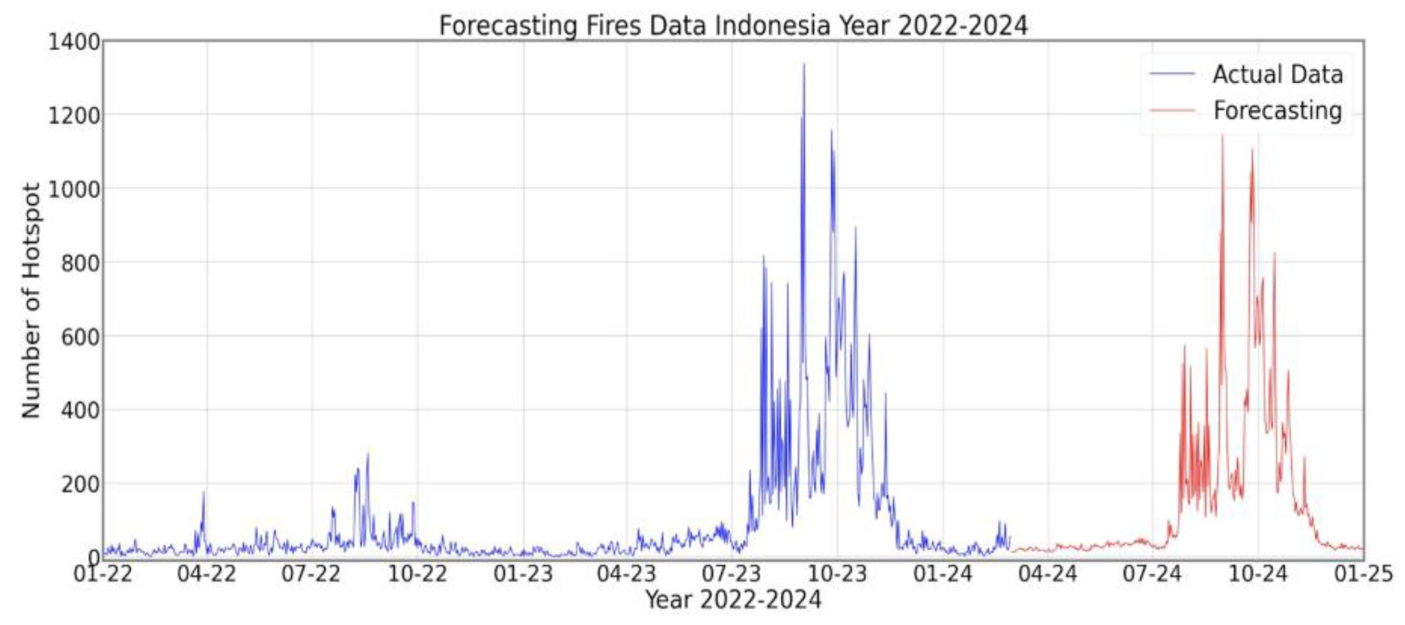
The detection results, visualized as hotspot distribution maps, are consistent with the reference data from NASA’s FIRMS. The mapping of fire-prone areas in Riau Province reveals that the CNN model effectively predicts the hotspot distribution, particularly during the dry season from August to October. In 2023, for example, the system detected a spike in hotspots reaching over 1,400 on several days, consistent with the reference data that recorded a significant increase in fires during the same period. These results demonstrate that CNNs are not only capable of accurately classifying hotspots but also facilitate forest fire early warning in Indonesia. When integrated with available real-time satellite imagery, the proposed system can be a valuable tool for the government, the Meteorology, Climatology, and Geophysics Agency (BMKG), and other environmental agencies in monitoring potential fires. However, this study also identified limitations, particularly in conditions where the imagery was obscured by thick clouds, which reduced the detection sensitivity. Therefore, integration with other high-resolution satellite data, such as Sentinel-2 or Landsat, and the development of cloud removal methods can serve as future improvements. Overall, the findings confirm that CNN-based detection systems using MODIS data offer advantages in terms of speed, accuracy, and adaptability to Indonesia’s geographic conditions. Sustainable implementation of the proposed system is expected to have a positive impact on forest and land fire mitigation efforts, reduce economic losses, and protect public health from exposure to the resulting haze. Figure 8 shows the graph of prediction for forest fire in Indonesia in 2024-2025.
5. Conclusions
This study demonstrated that a CNN-based forest fire detection system using MODIS satellite data could achieve effective and accurate results in identifying hotspots in Indonesia. The developed CNN model recognizes fire patterns with high accuracy, making it suitable for use as an early warning system in forest and land fire mitigation efforts. The results demonstrate that the integration of multispectral satellite imagery data, particularly thermal infrared and mid-infrared channels, strengthens the ability of the system to detect temperature changes and earth surface anomalies related to fires. The developed system has proven relevant and reliable in supporting the monitoring of fire-prone areas in Sumatra Island, which have long been the focus of attention for forest and land fire issues in Indonesia. Overall, the developed CNN-based detection system using MODIS data can serve as an innovative solution to mitigating forest fires in Indonesia. Sustainable implementation of the system is expected to not only improve the effectiveness of fire monitoring and management but also support national policies in reducing the environmental, health, and economic impacts of forest and land fires.
Acknowledgments
Thank you are extended to Kementrian Pendidikan Tinggi Sains dan Teknologi (KEMENDIKTISAINTEK) Indonesia with contract number: 31/DPPM-UIR/HN-P/2025, the university leadership, particularly the Rector of the Islamic University of Riau, and the staff of the Faculty of Engineering, who have provided the facilities, resources, and a conducive academic environment that have enabled this research to be successfully conducted. As well as to Universiti Sultan Zainal Abidin, Malaysia and Chiba University, Japan.
References
- An Liuqi, Chen Lan, and Hao Xiaoran, “Indoor Fire Detection Algorithm Based on Second-Order Exponential Smoothing and Information Fusion”, Scientific Report, Volume 15, 4187, 2025. [CrossRef]
- Evizal Abdul Kadir, Hitsohi Irie, Wan Aezwani Wan Abu Bakar, Sri Listia Rosa, Muhammad Fikri Evizal, and Farhan Assidiqi, “Satellite-Based Monitoring of Forest Fire Incidents in Sumatra Indonesia: Trends and Implications”, The 13th International Conference on Information and Communication Networks (ICICN 2025), Beijing 8-11 August 2025.
- Yanming Huang and Alfred Renaud, “The Application of CNN-Based Image Classification to Wildfire Early Detection”, Journal of Student Research, Volume 12, Issue 4, 2023.
- Evizal Abdul Kadir, Hsiang Tsung Kung, Sri Listia Rosa, Andrew Sabot, Mahmod Othman, and Mark Ting, “Wildfire Distribution Southeast Asia in and Forecasting Data for Future”, The IEEE Region 10 Symposium (TENSYMP), Mumbai India, 2022.
- U. R, S. SP, Ganesan, R, and U. S, “Forest Fire Detection using CNN-RF and CNN-XGBOOST Machine Learning Algorithms”, Third International Conference on Artificial Intelligence and Smart Energy (ICAIS), 2023.
- Chenyu Chaoxia, Weiwei Shang, and Fei Zhang, “Information-Guided Flame Detection Based on Faster R-CNN”, IEEE Access, Volume 8, 2020, pp. 58923- 58932. [CrossRef]
- Nesiga A, Sahani S Shetty, Mythili Mahesh Velapakam, Kiran Bailey, and Geetishree Mishra, “A Comparative Study of CNN Models Built with TensorFlow and Theano for Forest Fire Detection”, International Journal of Computer Sciences and Engineering, Volume 12, Issue 9, 2024, pp.1-8.
- Zaman Marzia, Upadhyay Darshana, Purcell Richard, Mutakabbir Abdul, Sampalli Srinivas, Lung Chung-Horng, and Naik, Kshirasagar, “A Systematic Machine Learning Methodology for Enhancing Accuracy and Reducing Computational Complexity in Forest Fire Detection”, MDPI Fire, Vol. 8, Issue 9, 2025.
- Guoli Zhang, Ming Wang, and Kai Liu, “Forest Fire Susceptibility Modeling Using a Convolutional Neural Network for Yunnan Province of China”, International Journal Disaster Risk Science, Volume 10, 2019, pp. 386–403. [CrossRef]
- Lidong Wang, Huixi Zhang, Yin Zhang, Keyong Hu, and Kang An, “A Deep Learning-Based Experiment on Forest Wildfire Detection in Machine Vision Course”, IEEE Access, Volume 11, 2023. [CrossRef]
- Deepa Das, Manthan Ghosh, Hitesh Gehani, Shruti Sarwate, Ashwini C.Gote, Priti Gade, Sagar Singh Rathore, Roshni Rathour, and Tanmoy Debnath, “CNN-Based Real-Time Forest Fire Detection: A Cost-Effective Solution”, Journal of Information Systems Engineering and Management, Volume 10, 2025.
- Özel Berk, Alam Muhammad S., and Khan Muhammad U., “Review of Modern Forest Fire Detection Techniques: Innovations in Image Processing and Deep Learning”, MDPI Information, Volume 15, Issue 9, 2024. [CrossRef]
- Reis Hatice Catal and Turk Veysel, “Detection of forest fire using deep convolutional neural networks with transfer learning approach”, Applied Soft Computinga, Volume 143, 2023.
- Guiop-Servan, Ruth E. Cotrina-Sanchez, Alexander Puerta-Culqui, Jhoivi Oliva-Cruz, and Manuel Barboza-Elgar, “Remote Sensing for Wildfire Mapping: A Comprehensive Review of Advances, Platforms, and Algorithms”, MDPI Fire, Volume 8, Issue 8, 2025. [CrossRef]
- Muhammad Iylia Rosli, Nur Afiqah Mohd Kamal, and Khamarrul Azahari Razak., “Remote Sensing Applications: Society and Environment, Remote Sensing Applications, Volume 23, 2021.
- Taye, Mohammad M, “Theoretical Understanding of Convolutional Neural Network: Concepts, Architectures, Applications, Future Directions”, MDPI Computation, Volume 11, Issue 3, 2023. [CrossRef]
- Meena U., Munjal G., Sachdeva S., Garg P., Dagar D., and Gangal, A, “RCNN Architecture for Forest Fire Detection”, 2023 13th International Conference on Cloud Computing, Data Science & Engineering (Confluence), 2023, pp. 699-704.
- Azlan Saleh, Mohd Asyraf Zulkifley, Hazimah Haspi Harun, Francis Gaudreaul, Ian Davison, and Martin Spraggon, “Forest fire surveillance systems: A review of deep learning methods”, Heliyon, Volume 10, 2024.
- Evizal Abdul Kadir, Akram Alomainy, Hanita Daud, Warih Maharani, Noryanti Muhammad, and Nesi Safitri, “Multi Sensor Network System for Early Detection and Prediction of Forest Fires in Southeast Asia”, 33rd International Telecommunication Networks and Applications Conference (ITNAC), Melbourne, Australia, 2023.
- Bhatt Shaifali and Chouhan Usha, “An enhanced method for predicting and analysing forest fires using an attention-based CNN model”, Journal of Forestry Research, Volume 35, Issue 1, 2024. [CrossRef]
- Evizal Abdul Kadir, Mahmod Othman, and Sri Listia Rosa, “Smart Sensor System for Detection and Forecasting Forest Fire Hotspot in Riau Province Indonesia”, The International Conference of Intelligent Computing and Informatics (ICOICS), Saudi Arabia, 2021. [CrossRef]
- Zhang Lianglin and Zhang Zhenke, “Wildfires and Climate Change as Key Drivers of Forest Carbon Flux Variations in Africa over the Past Two Decades”, MDPI Fire, Volume 8, Issue 8, 2025. [CrossRef]
- Evizal Abdul Kadir, Hsiang Tsung Kung, Amal Abdullah AlMansour, Hitoshi Irie, Sri Listia Rosa and Shukor Sanim Mohd Fauzi, “Wildfire Hotspots Forecasting and Mapping for Environmental Monitoring Based on the Long Short-Term Memory Networks Deep Learning Algorithm”, MDPI Environments, Volume 10, 2023. [CrossRef]
- S. Gayathri, P.V. Ajay Karthi, and Sourav Sunil, “Prediction and Detection of Forest Fires based on Deep Learning Approach”, Journal of Pharmaceutical Negative Results, Volume 13, Issue 3, 2022. [CrossRef]
- Yoo Seungmin, Kwon Chungeun, and Cha Sungeun, “Reproduction of Smaller Wildfire Perimeters Observed by Polar-Orbiting Satellites Using ROS Adjustment Factors and Wildfire Spread Simulators”, MDPI Remote Sensing, Volume 17, Issue 16, 2025. [CrossRef]
- Djarot Hindarto, “Comparison Accuracy of CNN and VGG16 in Forest Fire Identification: A Case Study”, Journal of Computer Networks, Architecture and High-Performance Computing, Volume 6, Issue 1, 2024. [CrossRef]
- Gazi Mohammad Imdadul Alam, Naima Tasnia, Tapu Biswas, MD. Jakir Hossen, Sharia Arfin Tanim, and MD Saef Ullah Miah, “Real-Time Detection of Forest Fires Using FireNet-CNN and Explainable AI Techniques”, IEEE Access, Volume 13, 2025. [CrossRef]
- Aral Rahmi Arda, Zalluhoglu Cemil, and Akcapinar Sezer, Ebru, “Lightweight and attention-based CNN architecture for wildfire detection using UAV vision data”, International Journal of Remote Sensing, Volume 44, Issue 18, 2023. [CrossRef]
- Tara Sistani and Seyed-Javad Kazemitabar, “Deep Learning Approach for Forest Fire Detection: A CNN Classification Model on the DeepFire Dataset”, Iranian Journal of Electrical and Electronic Engineering, Volume 22, Issue 4, 2025.
Figure 1.
Map of Sumatra Island in Indonesia.
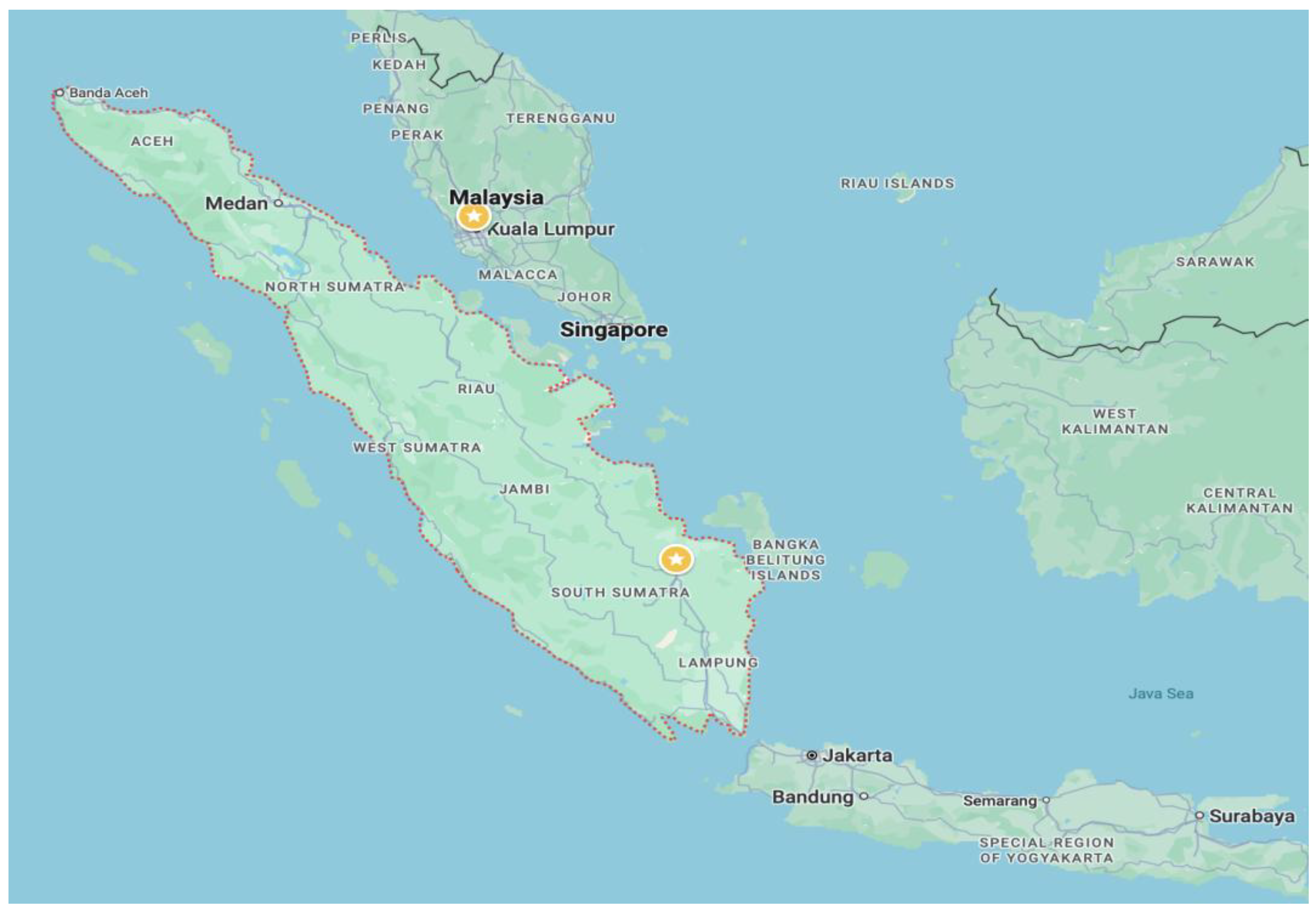
Figure 2.
Data processing steps of CNN algorithm to output neuron.
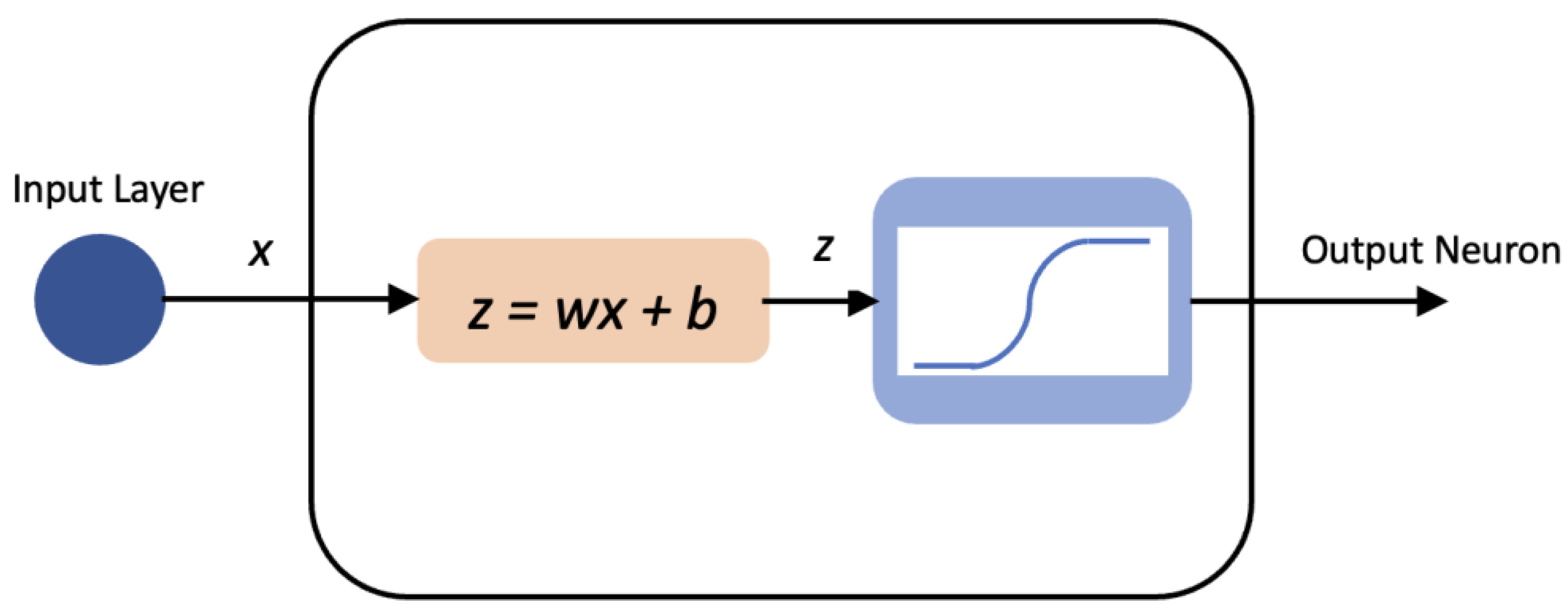
Figure 3.
CNN convolution process.

Figure 4.
Samples of images during fire in Riau province, Indonesia: (a) Pelalawan, (b) Dumai, (c) Bengkalis, and (d) Siak districts.
Figure 4.
Samples of images during fire in Riau province, Indonesia: (a) Pelalawan, (b) Dumai, (c) Bengkalis, and (d) Siak districts.
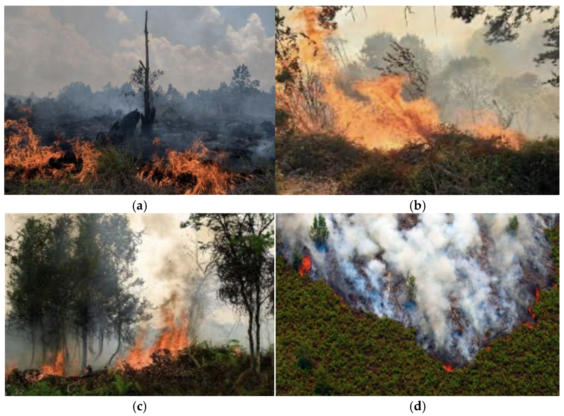
Figure 5.
Fire hotspot detected by CNN algorithm for fire in Riau province, Indonesia. (a) Pelalawan, (b) Dumai, (c) Bengkalis, and (d) Siak districts.
Figure 5.
Fire hotspot detected by CNN algorithm for fire in Riau province, Indonesia. (a) Pelalawan, (b) Dumai, (c) Bengkalis, and (d) Siak districts.
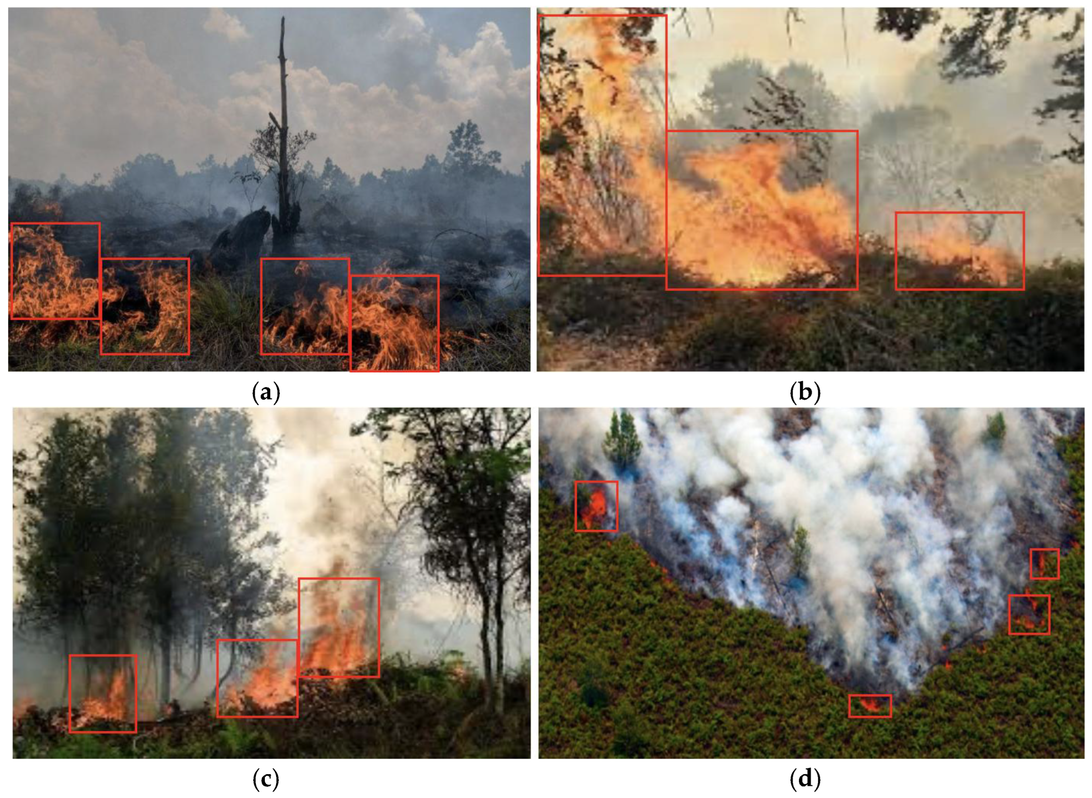
Figure 6.
Fire hotspots detected in Sumatra Island, Indonesia.
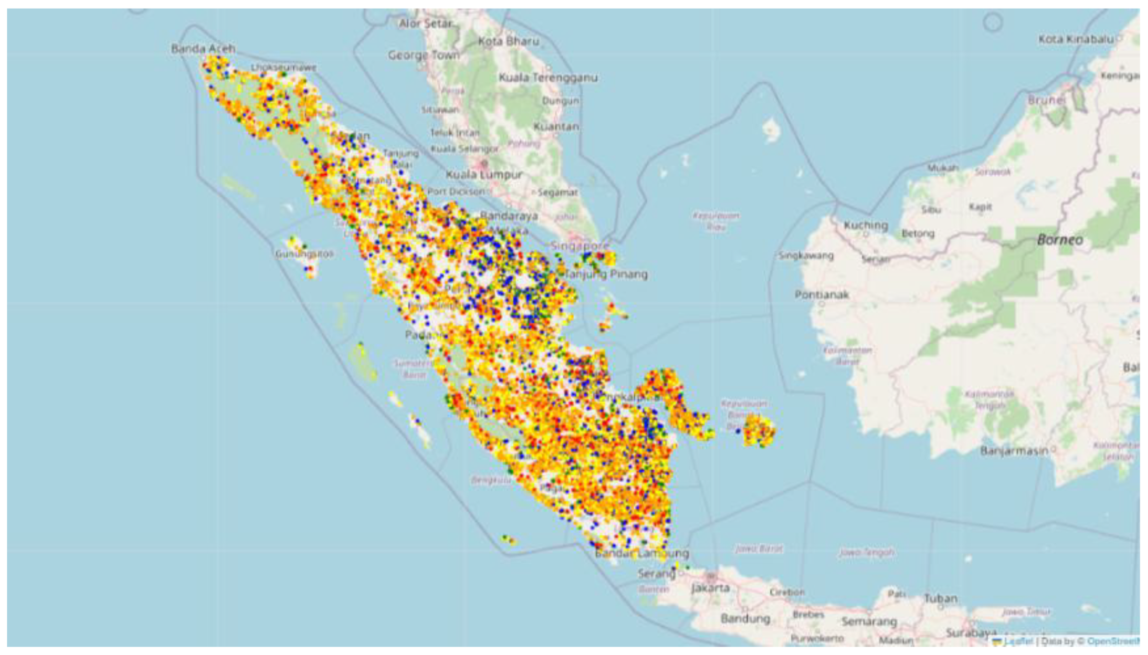
Figure 7.
Number of forest fire hotspots detected in Sumatra, Indonesia: (a) 2022 and (b) 2023.
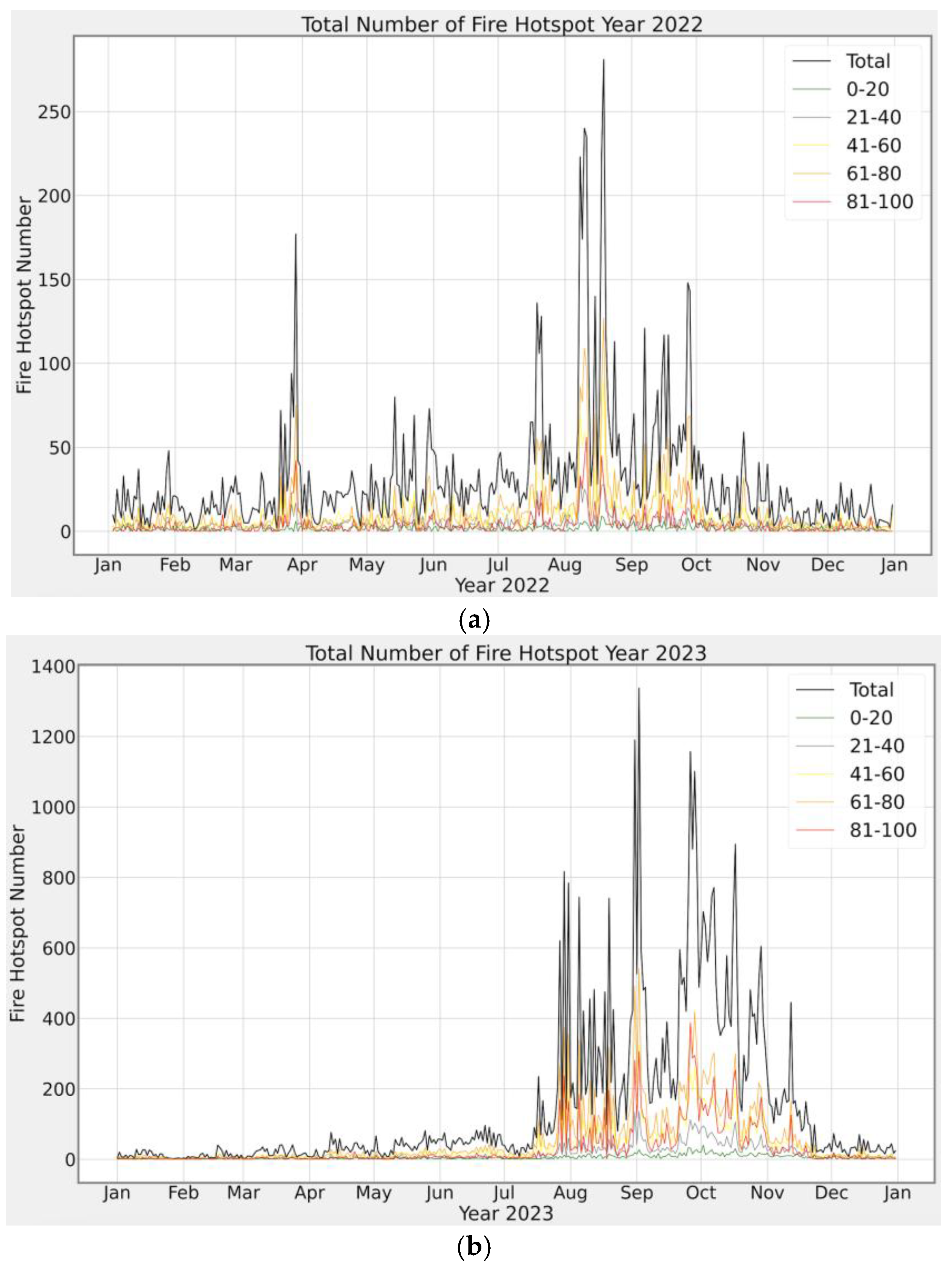
Figure 8.
Prediction of the number of fire hotspots for 2025.
Disclaimer/Publisher’s Note: The statements, opinions and data contained in all publications are solely those of the individual author(s) and contributor(s) and not of MDPI and/or the editor(s). MDPI and/or the editor(s) disclaim responsibility for any injury to people or property resulting from any ideas, methods, instructions or products referred to in the content. |
© 2025 by the authors. Licensee MDPI, Basel, Switzerland. This article is an open access article distributed under the terms and conditions of the Creative Commons Attribution (CC BY) license (http://creativecommons.org/licenses/by/4.0/).
Copyright: This open access article is published under a Creative Commons CC BY 4.0 license, which permit the free download, distribution, and reuse, provided that the author and preprint are cited in any reuse.


