Submitted:
10 October 2025
Posted:
14 October 2025
You are already at the latest version
Abstract
A recent comprehensive study, considered as important for the geodynamic, crustal and lithospheric geological structures and active tectonics in Vrancea, presented geological updates based on geophysical and geological data interpretation: a) Wrench tectonics system, crossing NE-SW the Romanian territory; b) Romanian Trough, interpreted as the prolongation of the Polish Trough beneath the East Carpathians; c) Volcanism and intrusive processes in the Vrancea area; d) Geophysical and tectonic model for the Vrancea seismic zone. When interpreting causes of Vrancea zone crustal seismicity, they are here considered to be associated at crustal depths with active normal faults situated within a graben geological structure, in an extensional regime. At lithospheric level the causes of high magnitude seismicity are related to strike-slip movements of a regional transcurrent fault, in a transtensional regime. High magnitude seismic events are considered to be located at the junction of the WT Southern Fault with a NW-SE trending strike-slip regional fault system, namely the Peceneaga-Camena, Capidava-Ovidiu and Mangalia faults.
Keywords:
1. Introduction
2. Seismicity of the Vrancea area
3. Regional Geodynamics
- Adriatic Sea: past subduction and subsequent collision related to the WSW-ENE directed compressional regime determined by the Apulia microplate. High seismicity occurring in the Durres-Shkoder zone;
- East Carpathians: NNW-SSE migrating subduction areas related to the eastward tectonic lateral escape, determined by the collision between Apulia microplate and Europe during the Miocene. The high compressional regime had as consequence the displacement of the Tisza-Dacia tectonic block toward the East European Platform. The subductions and collision processes, directed NE-SW, E-W and finally SE-NW, led to Neogene-Quaternary volcanism in the Calimani-Gurghiu-Harghita magmatic belt and high seismicity in the Vrancea zone;
- Hellenic Arc: present day subduction processes caused by the S-N displacement of the African Plate beneath the Eurasian Plate in the region of the Aegean Sea, volcanism occurring in several Aegean islands and seismicity in Greek islands and continental Greece.
4. Geology, Tectonics and Volcanism
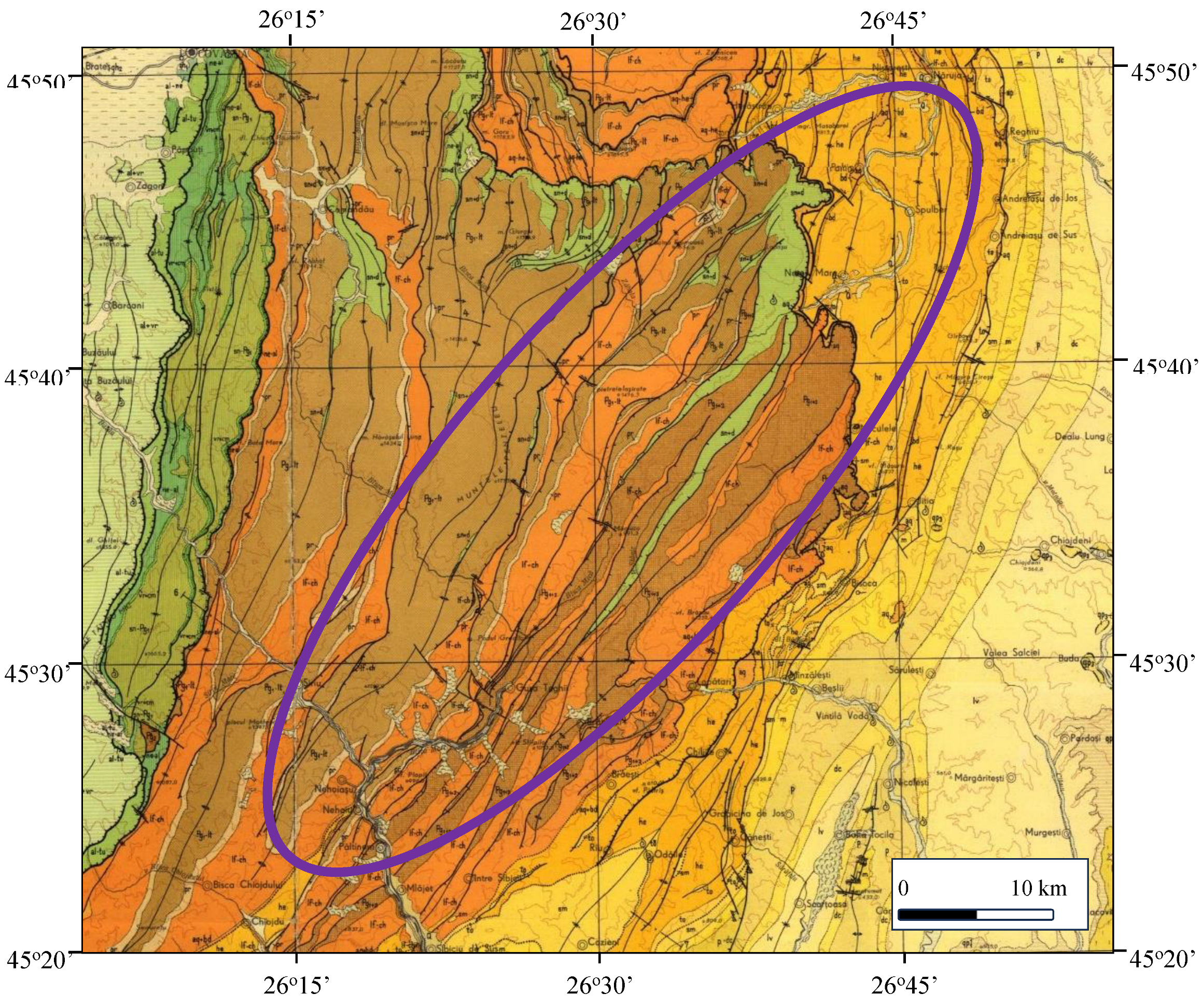
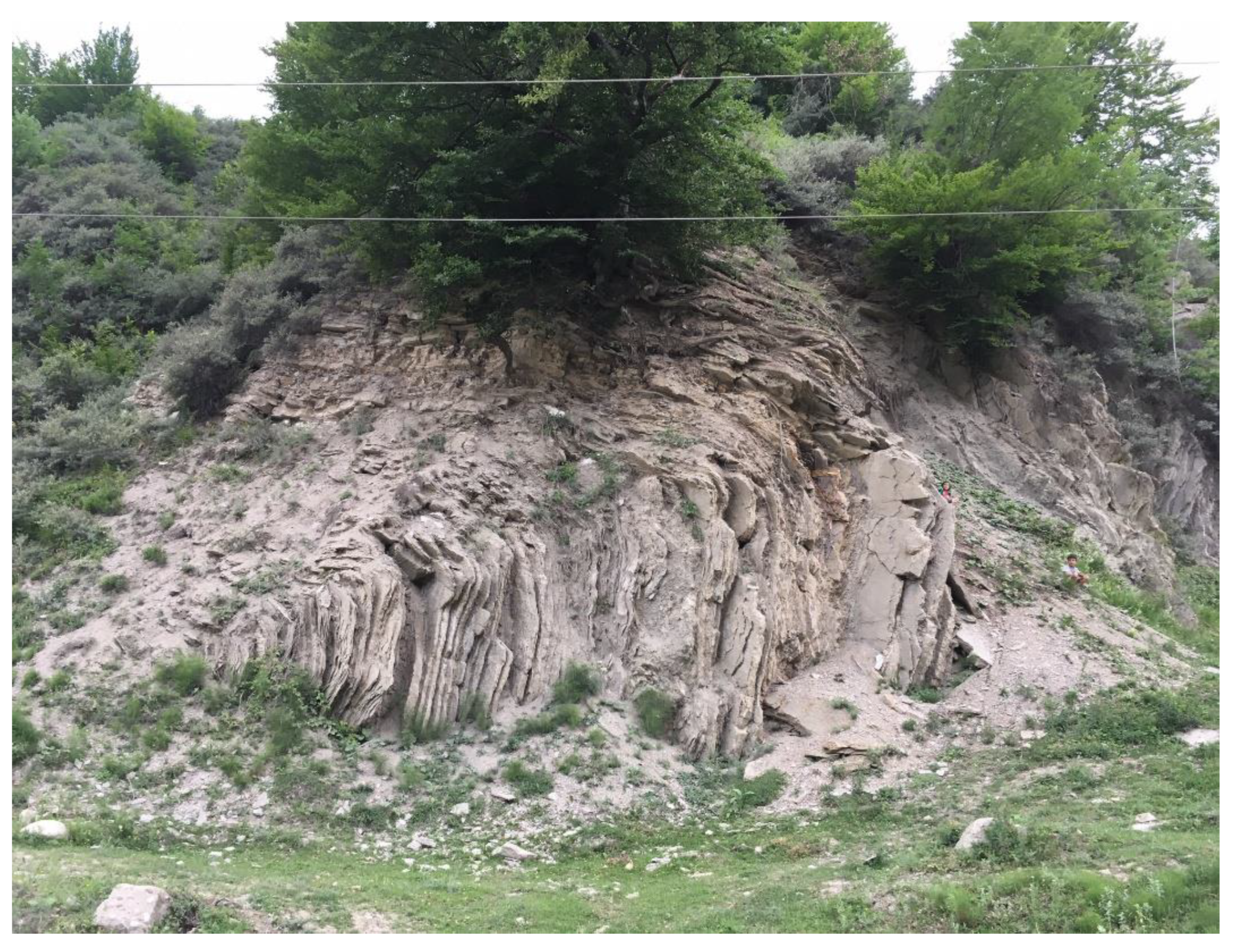
4.1. Geology of the Vrancea Seismic Area
4.2. Tectonics in and Around the Vrancea Seismic Zone
- a)
- Moesian Platform was considered as being eligible since its eastern compartment is situated beneath the Vrancea zone;
- b)
- East European Platform was considered a good candidate since it was involved in subduction along the East Carpathians, being developed at crustal and lithospheric depths beneath this mountainous chain. Numerous scientific projects and published scientific papers discussing subduction and post-subduction collision processes in the Vrancea zone interpreted that the East European Platform has been involved in regional tectonic processes of this kind.
4.3. Fault Systems
- a)
- the intermediate-depth high magnitude earthquakes occur many times deeper than 100 km depth;
- b)
- the western European scientists which studied Vrancea high seismicity within geological and geophysical projects, especially carried out during the 1990, built tectonic models upon their previous experience, using subduction and continent collision processes, and oceanic slab suite of oceanic lithosphere subduction or continental lithosphere delamination.
4.4. Volcanism in the Vrancea Zone
- a)
- aeromagnetic anomaly in the Vrancea zone;
- b)
- hydrothermal genesis of the Jitia metallic sulphides;
- c)
- hydrogeological observations.
5. Causes of High Magnitude Earthquakes in Vrancea
5.1. Crustal and Lithospheric Seismicity
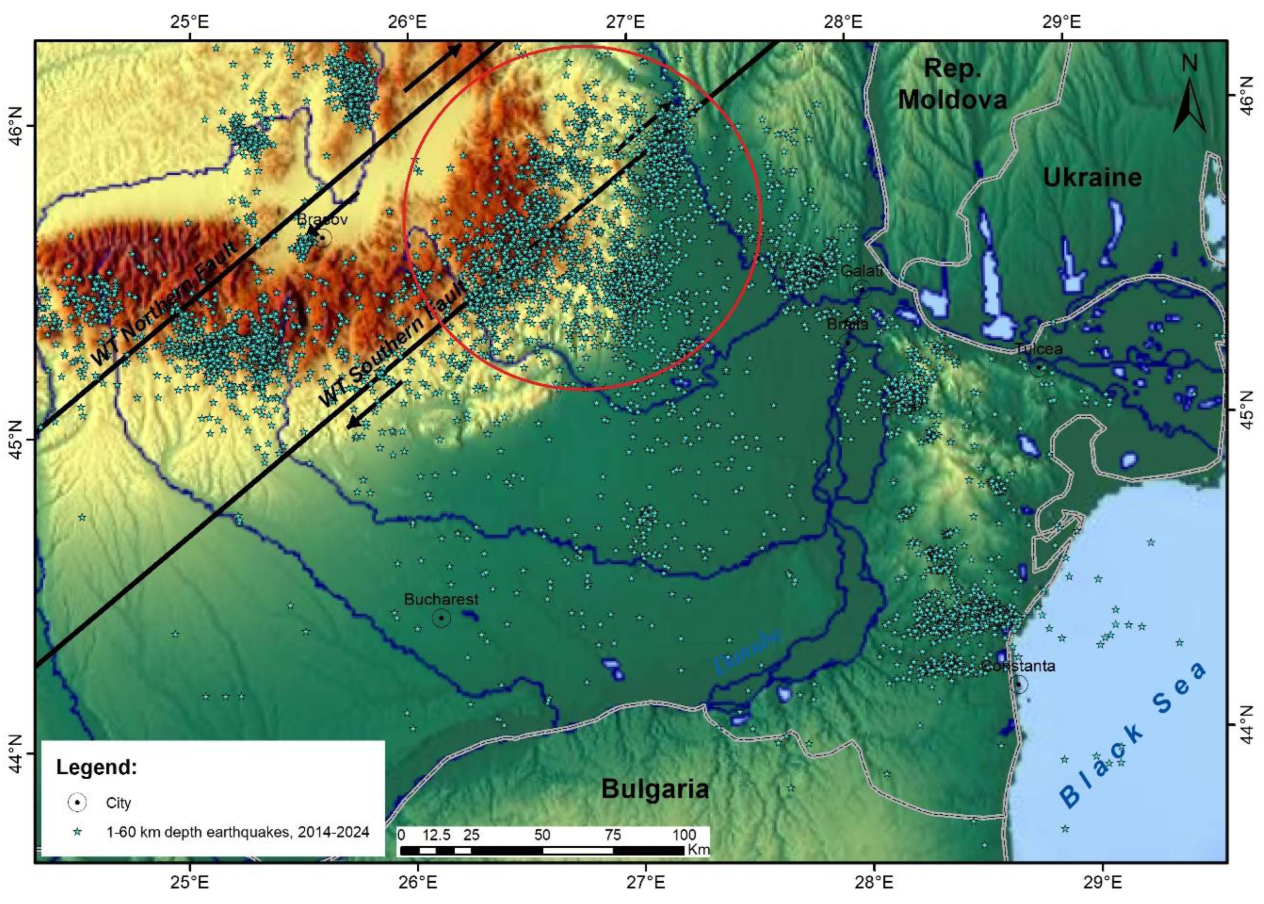
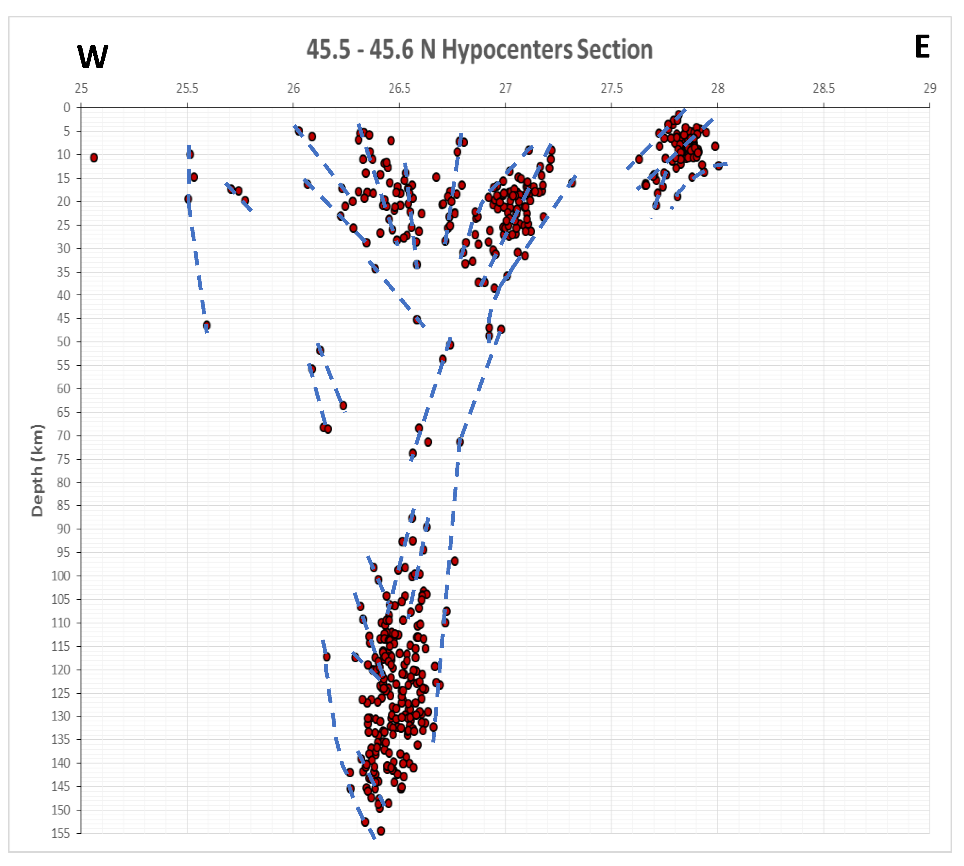
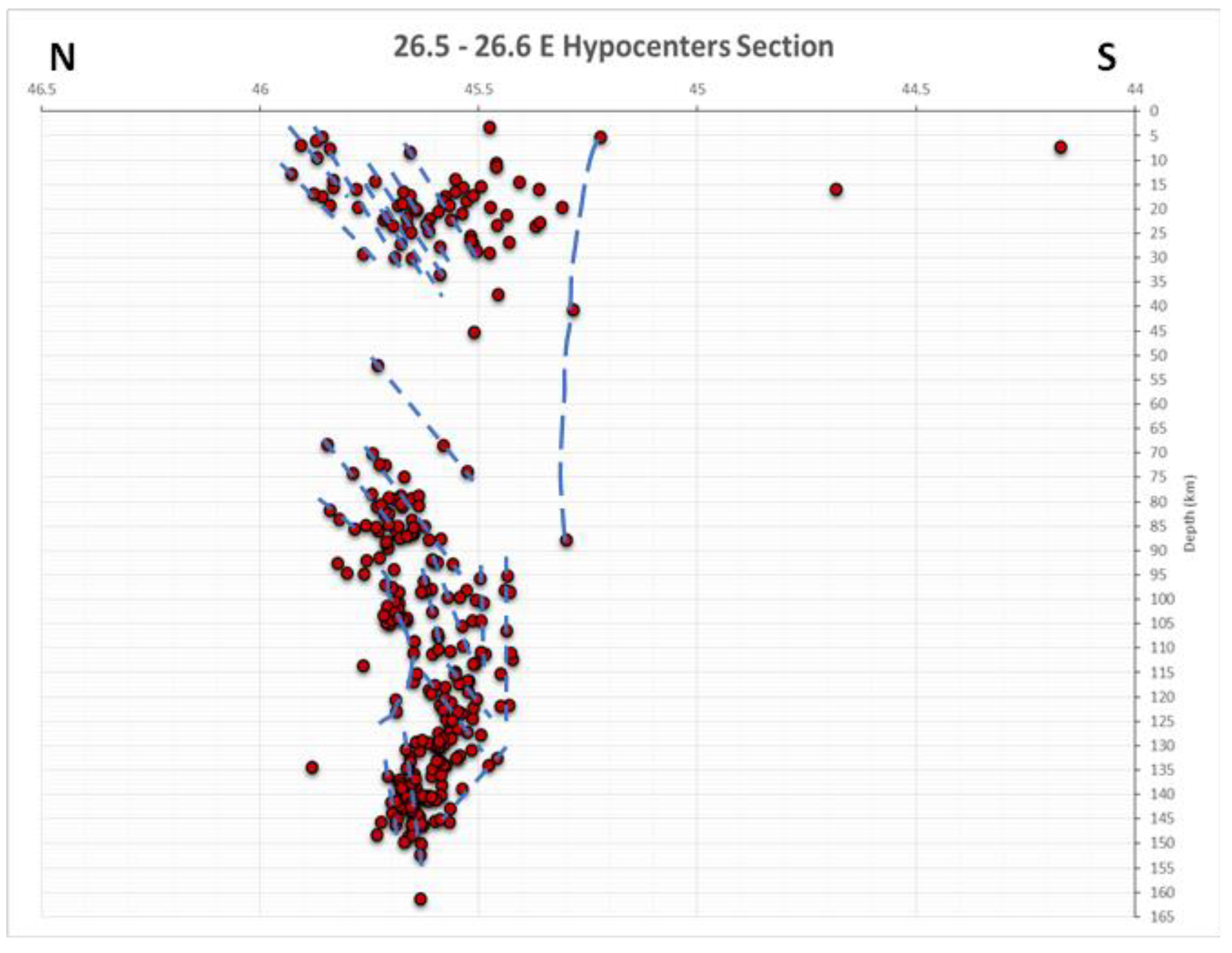
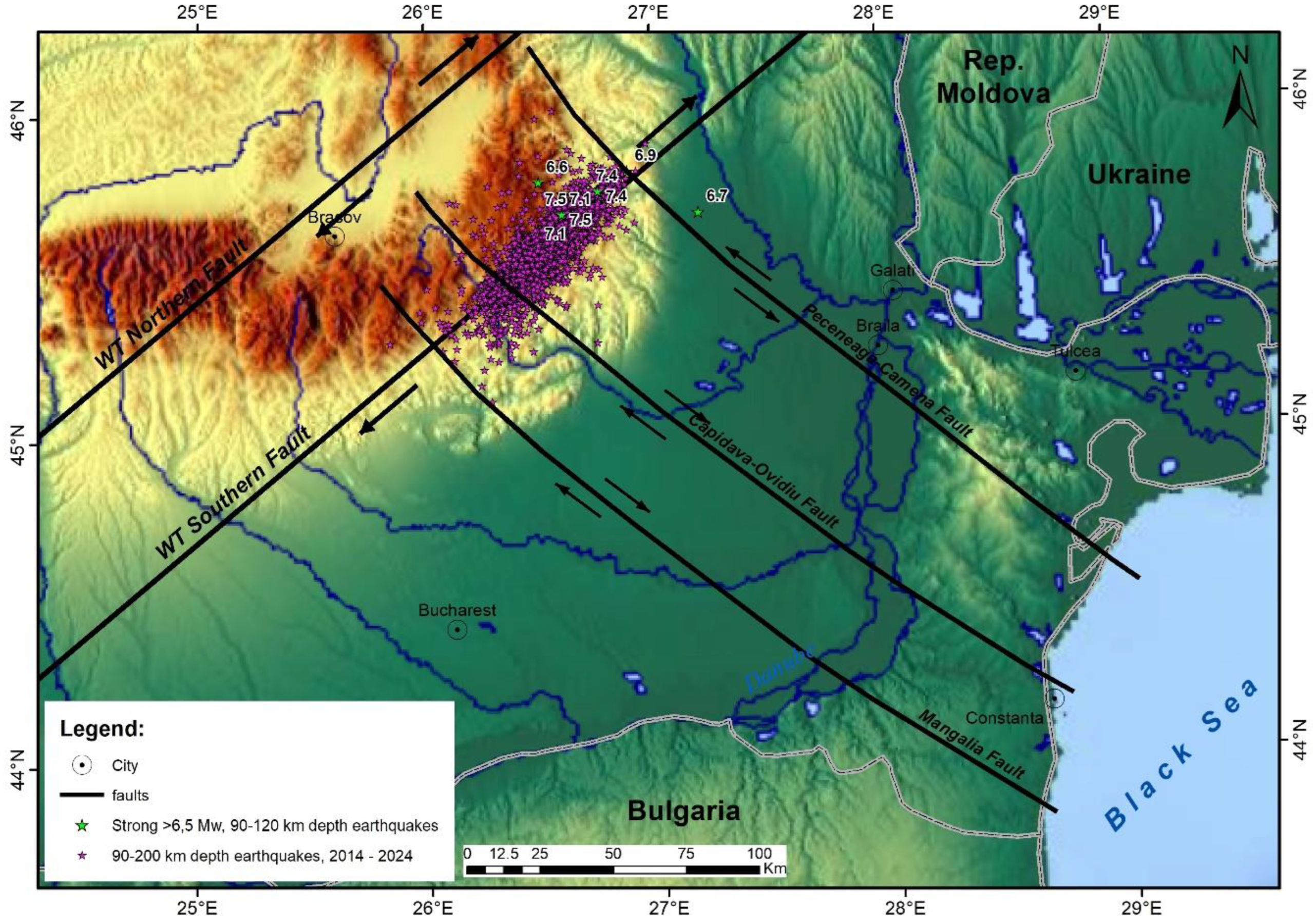
- the highest seismicity in Vrancea has been observed at the intersection zone between WT Southern Fault, trending NE-SW, and the NW-SE trending fault system, all faults being active and having strike-slip characteristics. At crustal depths the graben geological structure, detected by refraction seismic and illustrated by high seismicity till 60 km depth (Figure 2), has been reactivated by SE directed extensional tectonic processes, partly determined by geodynamic processes related to the eastward displacements of the northern compartment along the North Anatolian Fault.
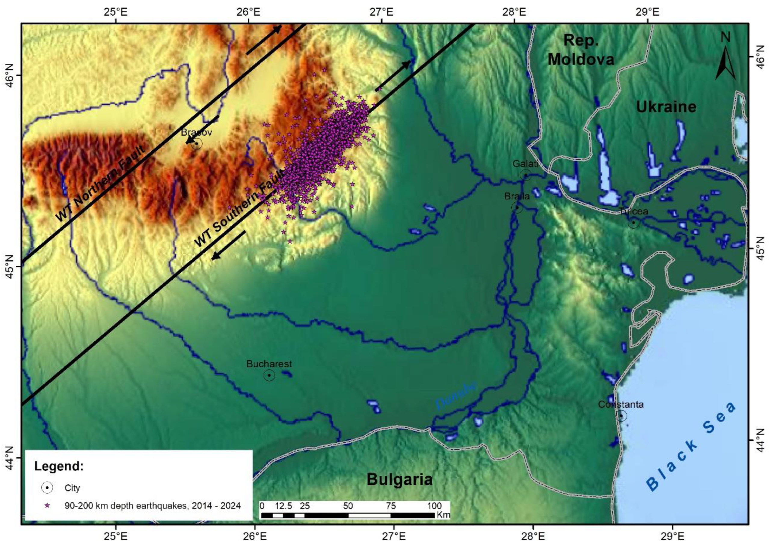
- seismicity sections, built till 160 km depth in Vrancea zone, may be interpreted as being associated with active extensional tectonics especially at crustal depths. At the deepest lithospheric depths the main tectonic processes, leading to intermediate-depth high magnitude earthquakes, are related to transtensional processes along the WT Southern transcurrent fault (Figure 7 and Figure 8) [3].
5.2. Causes of High Magnitude Earthquakes in Vrancea Seismic Zone
6. Conclusions
- crustal seismicity, determined by normal faults associated with the reactivated crustal graben-like structure, interpreted on refraction seismic, situated between 1 and 60 km depth;
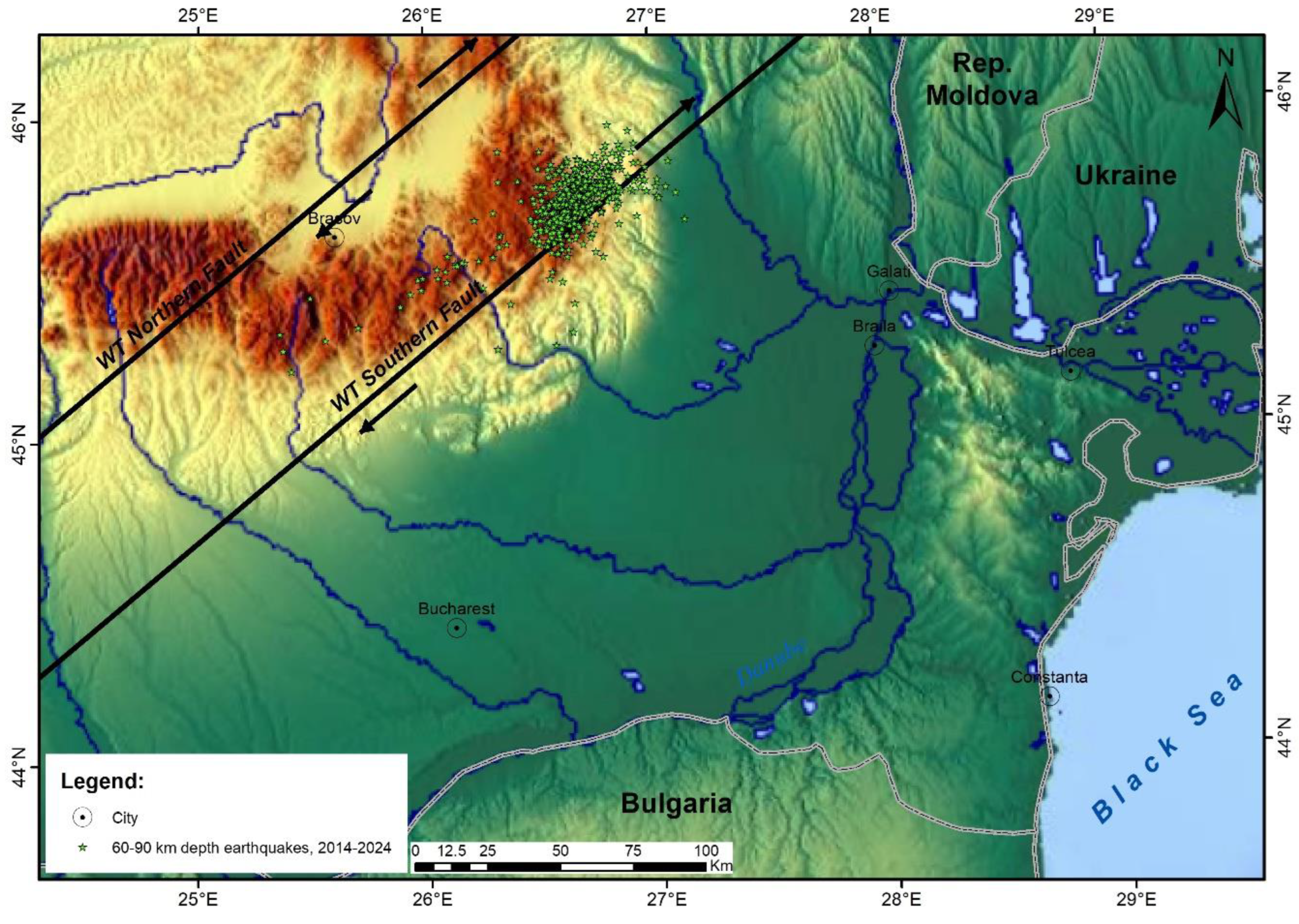
- seismicity recorded between 60 and 90 km depth, considered to be associated to the dynamics of the dioritic batholith, along the inner part of strike-slip WT Southern Fault and part of the Tisza-Dacia tectonic block, in collision with the East European Platform along the Casin-Bisoca Fault. It is likely that the surface expression of the Peceneaga-Camena crustal fault is here represented by the Casin-Bisoca Fault, acting as a tectonic contact. The seismic cluster located between 60 and 90 km depth shows that there is no vertical gap in the Vrancea seismicity;
- high magnitude seismic events, situated between 90 and 200 km depth, are mainly associated with the wrench tectonics system southern transcurrent fault, the horizontal displacements occurring along this regional strike-slip fault being associated with normal faulting in a transtensional regime.
Author Contributions
Funding
Data Availability Statement
Acknowledgments
Conflicts of Interest
References
- Braxmeier, H. Maps-For-Free. Available online: https://maps-for-free.com/ (accessed on 19 July 2025).
- Ioane, D.; Stanciu, I. Vrancea Seismic Zone - A New Geophysical Model Based on Wrench Tectonics, Volcanism and Regional Geodynamics. Rev. Roum. Géophys. / Rom. Geophys. J. 2021, 65, 3–47. [Google Scholar] [CrossRef]
- Ioane, D.; Stanciu, I.M. Extensional tectonics in Vrancea zone (Romania) interpreted on recent seismicity, geophysical and GPS data. In Proceedings of the 18th Int. Multidiscipl. Scient. GeoConf. Earth & Geosciences – SGEM2018, Albena, Bulgaria, Vol. 18, Issue 1.1, Applied and Environmental Geophysics, 2-8 July 2018; pp. 787–794. [Google Scholar]
- Ioane, D.; Stanciu, I. Tectonic and geodynamic model for the Vrancea seismic zone. Proceedings of Geosciences in the 21st century, Bucharest, Romania, Bucharest, Romania, 2019, 22 October 2019; GeoEcoMar Publishing House; Seghedi, A., Mocanu, V., Ilinca, G., Eds.; pp. 91–95, https://www.fluvimar.ro/Abstracte%20Conferinta/GEOSCIENCES%20IN%20THE%2021st%20CENTURY.pdf. [Google Scholar]
- Hauser, F.; Raileanu, V.; Fielitz, W.; Dinu, C.; Landes, M.; Bala, A.; Prodehl, C. Seismic crustal structure between the Transylvanian Basin and the Black Sea, Romania. Tectonophysics 2007, 430, 1–25. [Google Scholar] [CrossRef]
- Ioane, D.; Stanciu, I. Active Tectonics, Transcurrent Faults and High Magnitude Seismicity Zones: Durres (Albania) and Vrancea (Romania). Rev. Roum. Géophys. / Rom. Geophys. J. [CrossRef]
- Radu, C. Le regime seismique de la region de Vrancea. Rev. Roum. Géophys. 1965, 9, 49–64. [Google Scholar]
- Petrescu, L.; Enescu, B. Seismicity of a relic slab: space–time cluster analysis in the Vrancea Seismic Zone. Earth, Planets and Space 2025, 77, 6. [Google Scholar] [CrossRef]
- Romanian Earthquake Catalogue – ROMPLUS. Available online: https://www.infp.ro/index.php?i=romplus (accessed on day month year).
- Ioane, D. , Pantia, A.I., Stanciu, I. The Trans-European Suture Zone in Romania. In Extended Abstracts Volume of GEOSCIENCE 2019 Symposium, Bucharest, Romania, . https://appliedgeophysics.ro/GEOSCIENCE%202019_A3/. 22 November 2020. [Google Scholar]
- Dewey, J.F.; Pitman, C.W.; Ryan, F.B.; Bonnin, J. Plate tectonics and the evaluation of the Alpine system. Geol. Soc. Am. Bull. 1973, 84, 3137–3180. [Google Scholar] [CrossRef]
- van der Meer, D.G.; Hinsbergen, D.J.J.; Spakman, W. Atlas of the underworld: Slab remnants in the mantle, their sinking history, and a new outlook on the lower mantle viscosity. Tectonophysics 2018, 723, 309–448. [Google Scholar] [CrossRef]
- Hefty, J. Geokinematical modelling and strain analysis. In Proceedings of the 3rd CERGOP-2 Conference, Sofia, Bulgaria, Sep. 30-Oct. 1, 2004. Reports on Geodesy 2004, 4, 39–42. [Google Scholar]
- Munteanu, L. The kinematics of the tectonic blocks in the Vrancea area using modern high-precision satellitetechnology. In Researches on the Romanian earthquakes’ disaster management; Marmureanu, G., Ed.; Tehnopress, Iasi, Romania, 2009; pp. 482–546. (in Romanian)
- Sandulescu, M. Geotectonics of Romania. Technical Publishing House, Bucharest, Romania, 1984; 334 p. (in Romanian)
- Dumitrescu, I. , Sandulescu, M., Bandrabur, T. (1970), Geological map sheet 29 (Covasna), scale 1: 200,000. Geological Institute, Bucharest. Maps-For-Free. Available online: https://geo-spatial.
- Ioane, D.; Caragea, I. Western boundary of the East European Platform in Romania as interpreted on gravity and magnetic data. In Proceedings of the 8th Congress of the Balkan Geophysical Society, Chania, Greece, 4-8 October 2015. [Google Scholar] [CrossRef]
- Ioane, D.; Ion, D. , A 3D crustal gravity modeling of the Romanian territory. Journal Balkan Geophysical Society 2005, 8, 189–198. [Google Scholar]
- Fan, G.; Wallace, T.C.; Zhao, D. Tomographic imaging of deep velocity structure beneath the Eastern and Southern Carpathians, Romania: implications for continental collision. Journ. Geophys. Res. 1998, 103, 2705–2723. [Google Scholar] [CrossRef]
- Wortel, M.J.R.; Spakman, W. Subduction and Slab Detachment in the Mediterranean-Carpathian Region. Science 2000, 290, 1910–1917. [Google Scholar] [CrossRef] [PubMed]
- Constantinescu, L.; Constantinescu, P.; Cornea, I.; Lazarescu, V. Recent seismic information on the lithosphere in Romania. Rev. Roum. Géophys. 1976, 20, 33–49. [Google Scholar]
- Cornea, I.; Lazarescu, V. Geology and seismotectonics of Romania. In The earthquake of March 4, 1977 in Romania, Balan, S., Cristescu, V., Cornea, I., Eds.; Romanian Academy Publishing House, Bucharest, Romania, 1982; pp. 19–35. (in Romanian)
- Ioane, D.; Nutu-Dragomir, M.-L.; Diacopolos, C.; Stochici, R.; Stanciu, I.M. Looking for regional faults crossing Vrancea seismogenic zone. In Extended Abstracts Volume of GEOSCIENCE 2018 Symposium, Bucharest, Romania, . https://www.researchgate. 16 November 3290. [Google Scholar]
- Le Pichon, X.; Francheteau, J.; Bonnin, J. Plate Tectonics, Developments in Geotectonics, 6; Elsevier, Amsterdam, Netherlands, 1973; 300p.
- Kearey, P.; Klepeis, K.; Vine, F. Global Tectonics, 3rd ed.; Wiley-Blackwell Publishing House, Chichester, U.K. 2009. Available online: https://www.geokniga.org/bookfiles/geokniga-global-tectonics.pdf (accessed on 19 July 2025).
- Roman, C. Seismicity in Romania – evidence for a sinking lithosphere. Nature 1970, 228, 1176–1178. [Google Scholar] [CrossRef] [PubMed]
- Cristescu, Tr.; Stefanciuc, Al. Aeromagnetic surveys in Pannonian Depression, Apuseni Mts., East Carpathians, South Carpathians, Moesian Platform, Dobrogea, Transylvanian Depression, Moldavian Platform, Prospectiuni S.A. Archive, 1962-1968, Bucharest, Romania. (in Romanian)
- Cioflica, G.; Atanasiu, N.; Berbeleac, I.; Bita, I. Genesis of sulphide mineralization related to the Miocene molasse at Jitia (East Carpathians). Rev. Roum. Geol. 1986, 30, 3–20. [Google Scholar]
- Bandrabur, T.; Ghenea, C.; Ghenea, A. Craciun, P. Map of mineral and geothermal groundwater in Romania, scale 1: 1,000,000. Institute of Geology and Geophysics, Bucharest, Romania, 1981. (in Romanian)
- Gavat, I. , Airinei, S., Botezatu, R., Socolescu, M., Stoenescu, S.,The deep structures of the Romanian territory interpreted on recent geophysical data (gravity and magnetics). Stud. Cerc. Geofiz. 1963, 1, 7–30. (in Romanian). [Google Scholar]
- Visarion, M. , Sandulescu, M., Stanica, D., Veliciu, S., Contributions a la connaissance de la structure profonde de la plateforme Moesienne en Roumanie. Studii Tehnice si Economice 1978, 15, 211–222. [Google Scholar]
- Visarion, M. , Besutiu, L., Transcrustal faults on the Romanian territory. Studii si Cercetari, Geofizica 2001, 39, 15–33. [Google Scholar]
- Paraschiv, D.; Danet, N.; Popescu, M.; Dumitrescu, V. The present stage of pre-Jurassic deposits knowledge in South Dobrogea. Annuaire de l’Institut de Geologie et de Geophysique 1983, 59, 29–37. [Google Scholar]
Disclaimer/Publisher’s Note: The statements, opinions and data contained in all publications are solely those of the individual author(s) and contributor(s) and not of MDPI and/or the editor(s). MDPI and/or the editor(s) disclaim responsibility for any injury to people or property resulting from any ideas, methods, instructions or products referred to in the content. |
© 2025 by the authors. Licensee MDPI, Basel, Switzerland. This article is an open access article distributed under the terms and conditions of the Creative Commons Attribution (CC BY) license (http://creativecommons.org/licenses/by/4.0/).


