
Submitted:
01 October 2025
Posted:
02 October 2025
You are already at the latest version
Abstract
The collection of various agro-meteorological data is useful for a variety of studies. The purpose of this work is to find correlations between large data sets recorded by meteorological stations. These stations record various measurements (temperature, humidity, etc.) and are installed at various points across the wider plateau of Tripoli and the Peloponnese via the Sodasense digital platform. Our goal is to find correlations in order to draw useful conclusions.
Keywords:
Sodasense
; agrometeorological data
; data analysis
; correlations
1. Introduction
In this age of technology, much of what was true in the past has changed significantly in the modern era. The rapid development of technology and the spectacular increase in the use of digital media have contributed greatly to this.
As a result of the rapid development of technology, the science of Data Analysis could be considered relevant to the modern era. At the same time, it is particularly important that, over time, the functioning of many entities in the external environment is becoming increasingly complex. This means that more and more data is available. For this reason, there is a need to analyze this data [1].
The science of data analysis can help many businesses and organizations quickly analyze data and convert it into useful information. In most cases, the information obtained from data analysis can provide useful guidance, trends, and conclusions to businesses, organizations, and any entity operating in the external environment.
In addition, the science of data analysis can contribute to improved decision making, the optimization of many processes, and the creation of new opportunities related to the data being analyzed. It is a set of processes that could be said to have several advantages.
Firstly, it is particularly important that, through the data analysis process, raw data can be turned into useful information [2].
This information can be used to conclusions are drawn that improve a set of processes, extract various insights, aid in decision-making, create new standards depending on the industry to which the analysis relates, and give researchers the opportunity to draw various conclusions each time. In this way, one of the conclusions that emerges for the science of data analysis is that it helps researchers advance all kinds of research [2].
In this light, the research to be carried out as part of my thesis, entitled "Agrometeorological Data and Correlations between Data from the Sodasense Digital Platform," is evolving.
For the past year, I have been attending the Master's Program in Computer Science at the University of the Peloponnese and the School of Informatics and Telecommunications. As part of my postgraduate studies, I decided to proceed with this thesis, as Data Analysis is one of the subjects in Computer Science that interests me.
Thus, under the guidance of my supervisor, Mr. Wallace, I decided to proceed with the analysis of the data provided by the Sodasense platform.
Specifically, this platform is part of a funded project implemented under the "Peloponnese" program. It has been funded by the NSRF 2021-2027 and the European Union. The exact title of the program is "Sodasense: Advanced big data management with applications in transportation, climate, and agriculture." The aim of this program is to strengthen the competitiveness, attractiveness, and extroversion of the Peloponnese Region. This project also aims to strengthen quality entrepreneurship and the operation of small and medium-sized enterprises [3].
Numerous actions have been carried out as part of this program's effort to strengthen the Peloponnese Region, increase its attractiveness, and strengthen entrepreneurship. The most important of these, on which my thesis will be based, concerns the sensors that have been installed as part of this program at various locations in the Peloponnese. These sensors collect various types of data that can be linked to the microclimate of the region, agriculture, and weather conditions [3].
2. Dataset Description
The research i am conducting is based on data collected by sensors installed in the Peloponnese region and around the city of Tripoli regarding the microclimate and weather conditions of the area. Specifically, my thesis, taking into account the rules dictated by the science of data analysis, will proceed to analyze the data provided by sensors and meteorological stations in the Peloponnese Region and around the city of Tripoli.
The purpose of my research will be to analyze how the data obtained from these meteorological stations can be linked together.
In order to make the subject of my thesis more understandable, it is first necessary to refer to the locations where the sensors that will be used in my thesis have been installed, the parameters they study, as well as the time intervals that will concern the data to be analyzed in my research. The sensors gather a variety of agro-meteorological data, such as ambient temperature (usually between -5°C and 40°C), relative humidity (20–100%), rainfall (0–200 mm per day in extreme situations), sun radiation, wind speed (0–20 m/s), and atmospheric pressure. The SodaSense platform receives measurements that are sampled every ten minutes. The temperature, humidity, and pressure sensors have an accuracy of ±0.5°C, ±3%, and ±0.2 hPa, respectively over 1 million records were gathered from the seven stations [3].
First, it should be noted that my thesis has collected and will analyze data concerning the following time periods:
- 1/1/2023 – 30/6/2023
- 1/7/2023 – 31/12/2023
- 1/1/2024 – 30/6/2024
when the collection of data used in my thesis ends.The data collected by the sensors will cover the above time periods. The locations of the sensors from which the data will be collected are as follows:
- Ancient Nemea
- Nestani
- Zevgolatio
- Kamari
- Agios Georgios
- Chania Skopi
- Lake Taka
Measurements have been taken in these seven areas by two satellite stations and three main measuring stations.
The first and second satellite stations collect climate data from the above-mentioned points, such as:
- Leaf moisture
- Atmospheric temperature
- Atmospheric humidity
- Dew point and
- Thermohygrometer
The first main measuring station collects the following data:
- Wind direction
- Solar radiation
- Wind speed
- Wind gust
The second main measuring station collects the following data:
- Atmospheric temperature
- Atmospheric humidity
- Dew point and
- Thermohygrometer
The third main measuring station collects the following data:
- Atmospheric pressure
- Rainfall
The exact coordinates of the weather stations are:
Meteoshop 01: Ancient Nemea Latitude: 37.80762o Longitude: 22.70668o
Meteoshop 02: Nestani Latitude: 37.613963o Longitude: 22.465867o
Meteoshop 03: Zeugolation Latitude: 37.518o Longitude: 22.44117o
Meteoshop 04 Kamari Latitude: 37.44004o Longitude: 22.41246o
Meteoshop 05 Agios Georgios Latitude: 37.53042o Longitude: 22.37762o
Meteoshop 06 Chania Skopis Latitude: 37.55143o Longitude: 22.3983o
Meteoshop 07 Lake Taka Latitude: 37.4347o Longitude:22.37153o
The geographical distribution of meteorological stations, as shown on the map below [3]:
Figure 1.
Map of Meteorological Stations.
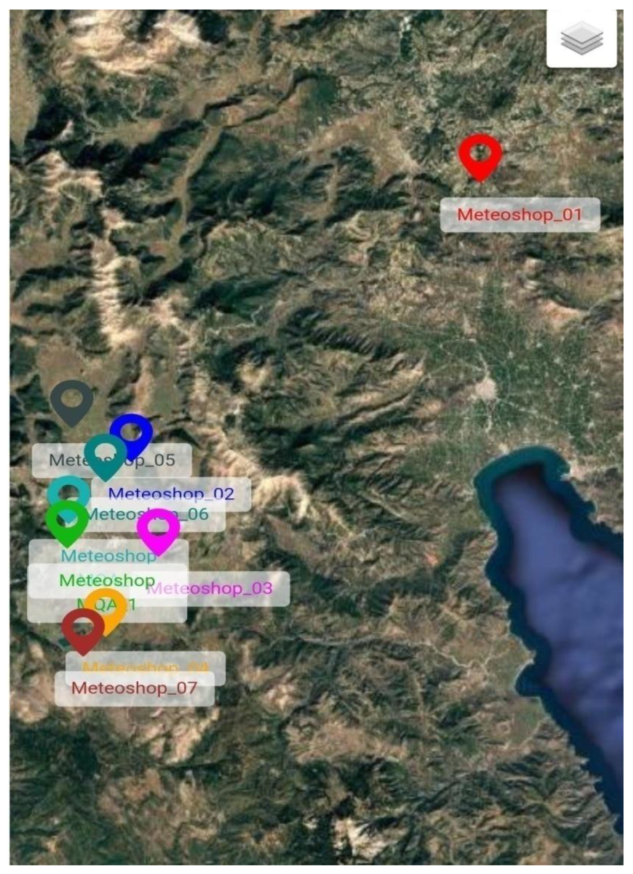
As shown on the map, almost all meteorological stations are concentrated on the Tripoli plateau, except for one located in the area of Ancient Nemea a place with significant lower altitude. (Meteoshop_01).
As a result of the difference in altitude, we can easily notice some differences between the area of ancient Nemea and the other areas located on the Tripoli plateau, both in terms of atmospheric pressure, as shown in the first graph, and in terms of mm of rainfall, as shown in the second graph.
In Figure 2 we notice the differences in atmospheric pressure between ancient Nemea and other stations on the Tripoli plateau
In Figure 3 we also notice different level of mm of rainfall between ancient Nemea and three stations on the Tripoli plateau
In Figure 4 we compare the meteorological station of Arch Nemea (Meteoshop01) with that of Nestani (Metroshop02) in terms of drew point, and we observe a clear difference in temperature between the two stations, but also a significantly greater variation in the values of Nestani compared to Arch Nemea.
3. Preliminary Results
There are obvious climate differences between Ancient Nemea and the sites on the Tripoli plateau, according to preliminary analysis of the data gathered. Because Nemea is lower in height, its atmospheric pressure values are consistently lower, but its rainfall patterns are more erratic than those of the plateau stations. Comparisons of the dew points in Nemea and Nestani show that Nestani has more fluctuations, which suggests that the local humidity dynamics are stronger. These findings demonstrate how microclimatic behavior is influenced by local terrain and altitude.
In order to investigate correlations between variables, we calculated pairwise correlations among a few chosen parameters. A summary of the findings is provided in Table 1. The investigation confirms the inverse association predicted in Mediterranean climates by demonstrating a high negative correlation between temperature and humidity (r = -0.72) [4]. While there is a high positive link between dew point and both humidity (r = 0.88) and temperature (r = 0.81), rainfall and humidity have a modest correlation (r = 0.54). These results show how the dataset may be used analytically and demonstrate its consistency.
4. Discussion
The results support the hypothesis that geographic location and elevation significantly influence climatic variables such as temperature, pressure, and humidity. According to the data gathered, Ancient Nemea shows different patterns than regions of the Tripoli plateau because of its higher elevation.
Agricultural planning (e.g., crop selection based on microclimate) can benefit from such knowledge.
Strategies for adapting to climate change and regional weather forecasting improvements.
In the fields of agriculture and the environment, data analysis can be used to uncover hidden patterns and trends that provide direction for both scientific study and real world decision making.
5. Conclusion
Finding relationships in the agrometeorological data gathered by the Sodasense digital platform in the Peloponnese region was the aim of this thesis. Analyzing the data revealed notable differences in the atmospheric conditions in various locations.
The results emphasize how crucial localized data collection and analysis are to comprehending and forecasting climate behavior. By supporting the objectives of the Sodasense project and the larger Peloponnese program, this research helps to integrate technology into regional development and create better informed environmental strategies. [5].
In the future, the dataset may be expanded to include more current or real-time data, and machine learning approaches for predictive analysis and uncover deeper correlations, may be integrated [6].
References
- M. Minelli, M. Chambers, and A. Dhiraj, Big Data, Big Analytics :Emerging Business Intelligence and Analytic Trends for Today's Businesses. Wiley, 2013.
- T. C. Redman and R. S. Kenett, The Real Work of Data Science: Turning Data into Information, Better Decisions, and Stronger Organizations. Wiley, 2019.
- P.Raftopoulou,S.Skiadopoulos,C.Tryfonopoulos,andC.Vasilakis,“SodaSense: Advanced big data management for mobility, micro-climate, and agriculture,” University of Peloponnese, 3-Oct-2024.
- L. Velea, T. Chronis, E. Anagnostou, and A. Papadopoulos,“Comparative analysis of humidity characteristics for open-sea andcoastal areas in the Mediterranean,” EMS Annual Meeting Abstracts,vol. 7, p. 434, 2010. [CrossRef]
- S. Kalogiannidis, D. Kalfas, O. Papaevangelou, F. Chatzitheodoridis,K.-N. Katsetsiadou, and E. Lekkas, “Integration of climate change strategies into policy and planning for regional development: A case study of Greece,” Land, vol. 13, no. 3, p. 268, 2024. [CrossRef]
- J. Šuljug et al., “A comparative study of machine learning models for predicting meteorological and agricultural applications,” Electronics, vol. 13, no. 16, p. 3284, 19-Aug-2024. [CrossRef]
Figure 2.
Atmospheric Pressure.
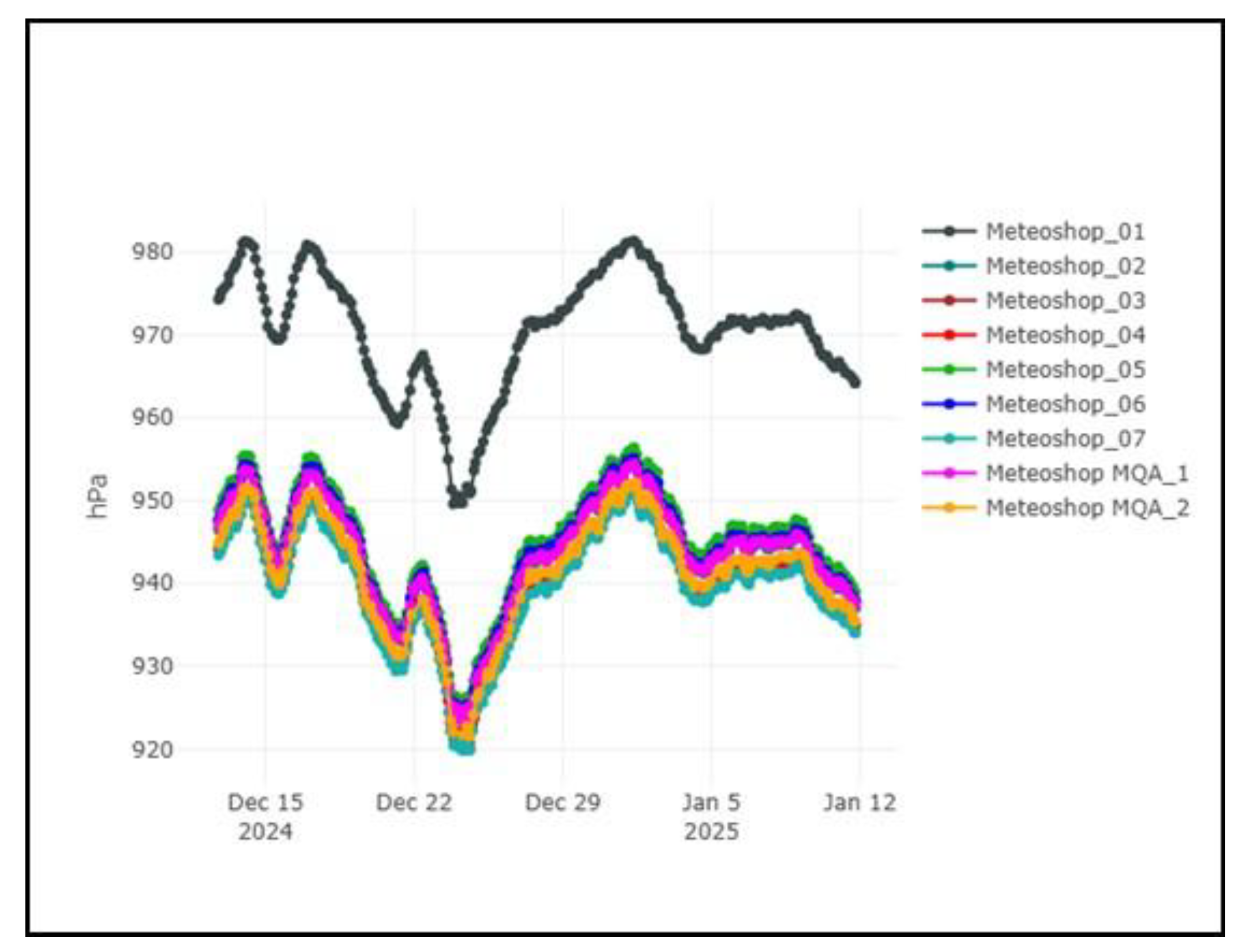
Figure 3.
Rainfall.
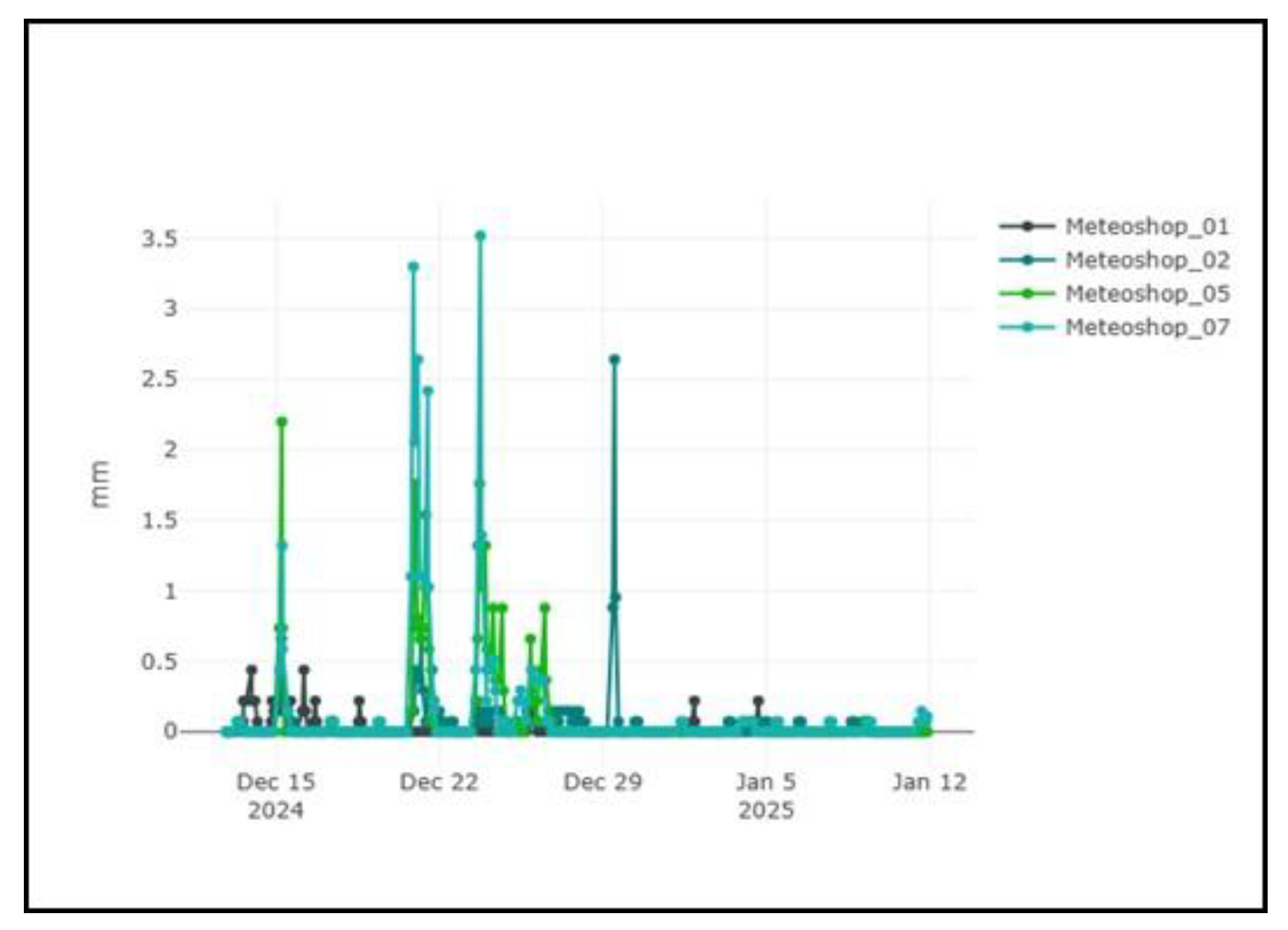
Figure 4.
Drew Point.
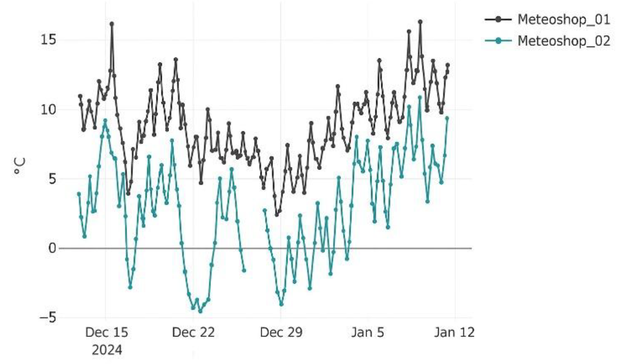

Table 1.
Caption.
| Parameter | Temperature | Humidity | Rainfall | Drew Point |
|---|---|---|---|---|
| Temperature | 1.00 | -0.72 | -0.35 | 0.81 |
| humidity | -0.72 | 1.00 | 0.54 | 0.88 |
| rainfall | -0.35 | 0.54 | 1.00 | 0.42 |
| drew Point | 0.81 | 0.88 | 0.42 | 1.00 |
Disclaimer/Publisher’s Note: The statements, opinions and data contained in all publications are solely those of the individual author(s) and contributor(s) and not of MDPI and/or the editor(s). MDPI and/or the editor(s) disclaim responsibility for any injury to people or property resulting from any ideas, methods, instructions or products referred to in the content. |
© 2025 by the authors. Licensee MDPI, Basel, Switzerland. This article is an open access article distributed under the terms and conditions of the Creative Commons Attribution (CC BY) license (http://creativecommons.org/licenses/by/4.0/).
Copyright: This open access article is published under a Creative Commons CC BY 4.0 license, which permit the free download, distribution, and reuse, provided that the author and preprint are cited in any reuse.


