Submitted:
15 August 2025
Posted:
18 August 2025
Read the latest preprint version here
Abstract
In post-disaster search and rescue (SAR) operations, unmanned aerial vehicles (UAVs) are essential tools, yet the large volume of raw visual data often overwhelms human operators by providing isolated, context-free information. This paper presents an innovative system with a cognitive-agentic architecture that transforms the UAV into an intelligent and proactive partner. The proposed modular architecture integrates specialized software agents for reasoning, coordinated by a large language model (LLM) acting as an orchestrator to handle high-level reasoning, logical validation, and self-correction feedback loops. A visual perception module based on a custom trained YOLO11 model feeds the cognitive core, enabling a complete perception–reasoning–action cycle. The system also incorporates a physical payload delivery module for first-aid supplies, reducing operator cognitive load and accelerating victim assistance through prioritized, actionable recommendations. This work, therefore, presents the first developed LLM-driven architecture of its kind that transforms a drone from a mere data-gathering tool into a proactive reasoning partner, demonstrating a viable path toward reducing operator cognitive load in critical missions.
Keywords:
UAV
; SAR
; cognitive architecture
; agentic AI
; decision support system
; LLM
1. Introduction
The first hours and days following a disaster — whether an earthquake, flooding or another natural or man-made disaster — are critical for saving lives. This initial phase is characterized by chaos, destruction and compromised infrastructure, creating extreme risk conditions that significantly hinder the rapid deployment of search and rescue teams. Reduced visibility, inaccessible terrain and, most importantly, a lack of accurate information about the extent of the damage and the location of victims, pose major obstacles to rescue operations. A prerequisite for crisis management is that critical decisions are largely based on the availability, accuracy and timeliness of information provided to decision-makers [3]. In these emergency situations, a fast response and the ability to obtain a reliable overview are crucial for maximizing the chances of survival for those who are trapped or missing.
In addition to physical obstacles, the deployment of human resources across multiple locations presents a logistical challenge that is often impossible to overcome [4], and the success of operations depends critically on the ability to overcome these logistical barriers [5]. In this context, unmanned aerial vehicles (UAVs) have emerged as an indispensable tool for conducting search and rescue missions in the early stages of disasters. Recent simulations have demonstrated the potential of drones, with over 90% of survivors located in less than 40 minutes in disaster scenarios [6]. Other studies have demonstrated similar success rates through multi-UAV collaboration [7], further enhancing the efficiency of these systems.
Although unmanned vehicles have transformed the way data is collected in disaster areas by generating impressive volumes of real-time video and sensory information, this abundance of data presents its own challenges. Human operators are still overwhelmed by the task of constantly monitoring video streams and identifying critical information, such as immediate risks. This information overload is a well-known issue that can lead to high cognitive load, causing operators to overlook relevant information [8,9]. Although existing computer vision systems, such as those based on YOLO (You Only Look Once) [10], can detect people, they often provide information that is isolated and lacks semantic context or state assessment. The major challenge is that detecting an object (a person) is insufficient. Future systems must enable a semantic understanding of the situation to support decision-making processes [11]. The current reliance on raw information places a significant cognitive burden on rescue teams, consuming time and increasing the risk of errors in decision-making. Therefore, there is a need to move beyond simple data collection towards contextual understanding and intelligent analysis, which could significantly ease the work of intervention teams [12].
To overcome these limitations and capitalize on the convergence of these fields, we propose a cognitive-agentic architecture that will transform drones from simple observation tools into intelligent, proactive partners in search and rescue operations. Our work’s key contribution lies in its modular agentic approach, where specialized software agents manage perception, memory, reasoning and action separately. At the heart of this architecture is the integration of a large language model (LLM) acting as an orchestrator agent — a feature that enables the system to perform logical validation and self-correction via feedback loops. To enable this reasoning, we have developed an advanced visual perception module based on YOLO11, which has been trained on a composite dataset. This module can perform detailed semantic classification of victims’ status, going beyond simple detection. This approach is necessary because accurately assessing disaster scenarios requires the semantic interpretation of aerial images, beyond simple detection [13]. Finally, we present a fully integrated cycle of perception, reasoning and action by incorporating a physical module for the delivery of first aid kits, thereby closing the loop from analysis to direct intervention. Using drones to rapidly deliver first aid supplies to disaster-stricken areas where access is difficult can have a significant impact on survival rates [14]. This integrated system’s main objective is to drastically reduce the cognitive load on human operators and accelerate the process of locating and assisting victims by providing clear, contextualized, actionable information.
This paper is structured as follows: Section 2 presents an analysis of relevant works in the field of UAVs for disaster response and AI-based SAR systems. Section 3 details the architecture and key components of the proposed cognitive approach, including the data-collecting hardware. Section 4 describes the implementation of the person detection module, including data acquisition, model training, and performance evaluation. Section 5 presents the algorithms used to map detected persons and assign them GPS coordinates to facilitate rescue. Section 6 describes every component of the cognitive-agentic architecture system. Section 7 presents the results of the feedback loop of cognitive architecture. Finally, Section 8 concludes the paper and presents future research directions.
2. Related Works
The field of unmanned aerial vehicle (UAV) use in SAR operations has evolved rapidly, progressing from basic remote sensing platforms to increasingly autonomous systems. To contextualize our contribution, we analyze the literature from three complementary perspectives: specialized UAV systems for SAR sub-tasks; cognitive architectures for situational awareness; and, most importantly, the emerging paradigm of agentic robotic systems based on large language models (LLMs).
This paper [15] proposes an innovative method of locating victims in disaster areas by detecting mobile phones that have run out of battery power. The system uses a UAV equipped with wireless power transfer technology to temporarily activate these devices and enable them to emit a signal. The drone then uses traversal graph and clustering algorithms to optimize its search path and locate the signal sources, thereby improving the efficiency of search operations in scenarios where visual methods are ineffective.
The issue of how to plan drone routes for search and rescue missions is dealt with in article [16]. The authors propose a genetic algorithm-based algorithm that aims to minimize total mission time while simultaneously considering two objectives: achieving complete coverage of the search area and maintaining stable communication with ground personnel. The innovation lies in evaluating flexible communication strategies (e.g., ‘data mule’, relay chains), which allow the system to dynamically adjust the priority between searching and communicating. Through simulations, the authors demonstrate a significant reduction in mission time.
In [17], the authors focus on the direct interaction between the victim and the rescue drone. The proposed system uses a YOLOv3-Tiny model to detect human presence in real time. Once a person has been detected, the system enters a phase of recognizing gestures, thus enabling effective non-verbal communication. The authors created a new dataset comprising rescue gestures (both body and hand), which enables the drone to initiate or cancel interaction and overcome the limitations of voice communication in noisy or distant environments.
Article [18] proposes a proactive surveillance system that uses UAVs. This system is designed to overcome the limitations of teleoperated systems by exhibiting human-like behavior. The main innovation lies in the use of two key components: Semantic Web technologies for the high-level description of objects and scenarios and a Fuzzy Cognitive Map (FCM) model to provide cognitive capabilities for the accumulation of spatial knowledge and the discernment of critical situations. The system integrates data to develop situational awareness, enabling the drone to understand evolving scenes and make informed decisions rather than relying solely on simple detection.
Unlike previous approaches, which focused on isolated tasks, our fundamental contribution is a cognitive-agentic system based on a proactive cognitive-agentic architecture. The main innovation is the use of large language models (LLM) as specialized agents capable of logical validation and self-correction via feedback loops. This surpasses the flexibility of traditional cognitive models.
Powered by an advanced perception module that provides a detailed semantic understanding of victims’ conditions, our system can deliver first aid packages, closing the full cycle from analysis to direct intervention. This transforms the drone into a proactive partner, drastically reducing the cognitive load on operators and accelerating the process of assisting victims.
3. Materials and Methods Used for the Proposed System
This section outlines the key components and methodological approaches of the intelligent system. The aim is to demonstrate how these components contribute to the system’s overall functionality and efficiency, enabling autonomous operation in complex disaster response scenarios.
The choice of unmanned aerial vehicle (UAV) platform is critical to the development of autonomous search and rescue systems, directly influencing their performance, cost and scalability. For this study, we chose a customized multi-motor drone that balances research and development requirements with operational capabilities. Table 1 compares the technical parameters of the proposed UAV platform with those of two representative commercial systems: The DJI Matrice 300 RTK is a multi-engine platform used in professional applications, while the other is a fixed-wing VTOL UAV.
We chose a custom-built model because while others might offer more performance at a lower cost, our model was more versatile in the development stage and even in repairs, while the commercial solutions are tied to their own branding of spare parts, our choice can be changed very easily to new parts.
To improve understanding of the system, Figure 1 illustrates the drone system architecture, showing how the modules (e.g., sensors, communication units, and control elements) interact. This modular design allows for the integration of functionalities such as navigation, data acquisition and victim detection, facilitating real-time processing and coordination.
The system operates via a continuous, integrated flow of data. It collects information from sensors and video streams via the ESP32S3 MPU, which is installed on board the drone. This data is then transmitted in real time to the ground command center via a secure connection using the 802.11 b/g/n standard (2.4 GHz Wi-Fi for the prototype phase).
Once received, the ground device directs the video stream to the YOLO11 module for preliminary identification of individuals. Both the processed and original video streams, along with the sensor data, are stored and transmitted to the command center for in-depth analysis and the generation of concrete recommendations.
The frequency at which our system acquires data is strategically configured to strike a balance between informational relevance and resource efficiency. Primary GPS location data is updated at a rate of 1 Hz. To improve the accuracy of distance measurements, values from the LiDAR sensor are acquired at 2 Hz. This enables two LiDAR readings to be taken for each GPS update, facilitating the calculation of a median value which contributes to noise filtering and providing more robust data for environmental assessment.
The system primarily uses standard commercial components. This approach was adopted to enable rapid development, facilitating concept validation and algorithm refinement in a controlled environment. While these components are not particularly robust, they are adequate for the prototyping phase. For operational deployment in the field, however, it is anticipated that a transition to professional-grade hardware specialized for hostile environments will be necessary.
The following sections will provide an overview of the platform’s capabilities by describing the main hardware and software elements, from data acquisition and processing to the analysis core.
3.1. Flight Module
The flight module is the actual aerial platform. It was built and assembled from scratch using an F450 frame and an FPV drone kit. This approach enabled detailed control over component selection and assembly, resulting in a modular, adaptable structure. The proposed drone is a multi-motor quadcopter, chosen for its stability during hovering flight and its ability to operate in confined spaces.
Figure 2 shows the physical assembly of the platform, which forms the basis for the subsequent integration of the sensor and delivery modules.
The drone is equipped with 920KV motors and is powered by a 2650mAh LiPo battery, ensuring a balance of power and efficiency. This hardware configuration gives the drone an estimated payload capacity of 500 g–1 kg. Based on this configuration, the estimated flight time is 12–15 minutes under optimal conditions. However, this can be directly influenced by the payload carried (especially the 300–700 g delivery package) and the flight style. These parameters are ideal for the small-scale laboratory and field tests required to validate cognitive architecture.
The drone is controlled via a radio controller and receiver to ensure a reliable command link. Under optimal conditions with minimal interference, the estimated range of the control system is 500 to 1,500 meters. The flight control board includes an STM32F405 microcontroller (MCU), a 3-axis ICM42688P gyroscope for precise stabilization, an integrated barometer for maintaining altitude and an AT7456E OSD chip for displaying essential flight data on the video stream. The motors are driven by a 55A speed controller (ESC). The flight controller supports power inputs from 3S to 6S LiPo. Additionally, it features an integrated ESP32 module through which we can configure various drone parameters via Bluetooth, enabling us to adjust settings at the last moment before a mission.
An important feature of the module is that the flight controller is equipped with a memory card slot. This allows continuous recording of all drone data, functioning similarly to an aircraft’s ‘black box’. Vital flight and system status information is saved locally and can be retrieved for analysis and for troubleshooting purposes.
3.2. Data Acquisition Module
The data acquisition module is designed as an independent, modular unit that acts as the drone’s sensory nervous system, collecting multi-modal information from the surrounding environment. It acts as a bridge between the physical world and cognitive architecture, playing a critical role in providing the necessary raw data (visual, positioning and proximity) for ground agents to build an overall picture of the situation.
The data acquisition module is designed to operate as a stand-alone unit, integrating multiple sensors:
- Main MPU: It features a 32-bit, dual-core Tensilica Xtensa LX7 processor that operates at speeds of up to 240 MHz. It is also equipped with 8 MB of PSRAM and 8 MB of Flash memory, which provides ample storage for processing sensor data and managing video streams.
- Camera: Although the ESP32S3 MPU is equipped with an OV2640 camera sensor, a superior OV5640 camera module has been added to enhance image quality and transmission speed. This enables higher-resolution capture and faster access times, providing the analysis module with higher-quality visual data at a cost-effective price.
- Distance sensor (LIDAR): A TOF LIDAR laser distance sensor (VL53LDK) is used. It is important to note that this sensor has a maximum measurement range of 2 meters, with an accuracy of ±3%. The sensor has a maximum measurement range of up to 2 meters and an accuracy of ±3%. Although this sensor is not designed for large-scale mapping, it enables proximity awareness and estimation of the terrain profile immediately below the drone. This data is essential for low-altitude flight and for the victim location estimation algorithm.
- GPS module: A GY-NEO6MV2 module is integrated to provide positioning data with a horizontal accuracy of 2.5 meters (circular error probable) and an update rate of 1 Hz.
Integrating these components into a compact and efficient package is essential for the module’s functionality. Figure 3 shows how the acquisition system’s hardware is assembled, highlighting that the ESP32S3 MPU serves as the central processing unit to which the camera, LiDAR sensor and GPS module are directly connected. This minimalist configuration ensures low weight and optimized energy consumption, both of which are crucial for maintaining the drone’s flight autonomy.
These sensors were chosen based on the project’s specific objectives. GPS data enables the route to be recorded, and combining information from LiDAR and the camera facilitates victim positioning and awareness of nearby obstacles.
The ESP32S3 runs optimized code to streamline video transmission and ensure the best possible video quality in operational conditions. It also exposes specific endpoints, enabling detailed sensor data to be retrieved on demand. Data is transmitted via Wi-Fi (2.4 GHz, 802.11 b/g/n).
3.3. Delivery Module
In addition to its monitoring functions, the system includes an integrated package delivery module designed to provide immediate assistance to identify individuals. The release mechanism, which controls the opening and closing of the clamping system, is powered by a servo motor (e.g., SG90 or similar) that is directly integrated into the 3D-printed structure. The servo motor is remotely controlled and connected to the flight controller, enabling the human operator to operate it remotely based on decisions made in the command center, potentially with the assistance of recommendations from the cognitive architecture.
Figure 4 illustrates the modular design of the package’s fastening and release system, showing the 3D-printed conceptual components and an example package.
As shown in Figure 5, the drone can transport and release controlled first aid packages containing essential items such as medicine, a walkie-talkie for direct communication, a mini-GPS for location tracking and food rations. This module has an estimated maximum payload of 300–700 g, enabling critical resources to be transported. Integrating this module transforms the drone from a passive observation tool into an active system that can rapidly intervene by delivering critical resources directly to victims in emergency situations.
3.4. Drone Command Center
The drone command center, also known as the Ground Control Station (GCS), forms the operational and computational core of the entire system. Implemented as a robust web application with a ReactJS frontend and a Python backend, it ensures a scalable and maintainable client-server architecture.
The command center’s role goes beyond that of a simple visualization interface. It functions as a central hub for data fusion, intelligent processing, and decision support. Its main functionalities are:
- Human-Machine Interface (HMI): The front end gives the human operator complete situational awareness. A key feature is the interactive map, which displays the drone’s position in real time, the precise location of any detected individuals and other relevant geospatial data. At the same time, the operator can view the live video stream annotated in real time by the detection module which highlights victims and classifies their status (e.g., walking, standing, or lying down). Figure 6 shows the visual interface of the central application, which consolidates these data streams.
- 2.
-
Perceptual and cognitive processing: One of the fundamental architectural decisions behind our system is to decouple AI-intensive processing from the aerial platform and host it at the GCS level. The drone acts as an advanced data collection platform, transmitting video and telemetry data to the ground station. Here, the backend takes this data and performs two critical tasks:
- a.
- Visual detection: Uses the YOLO11 object detection model to analyze the video stream and extract semantic information. This off-board approach allows the use of complex, high-precision computational models, that would otherwise exceed the hardware capabilities of resource-limited aerial platforms.
- b.
- Agentic Reasoning: The GCS hosts the entire cognitive-agentic architecture. This architecture is detailed in Section 6. All interactions between AI agents, including contextual analysis, risk assessment and recommendation generation, take place at the ground server level.
This centralization of intelligence enables our system to surpass the standard AI functionalities integrated into commercial drones, which typically focus on flight optimization (e.g., AI Spot-Check or Smart Pin & Track). Our system offers a deeper reasoning and contextual analysis capabilities.
Furthermore, the command center is the interface point where prioritized recommendations generated by the cognitive-agentic architecture are presented to the operator. This centralization of raw data, processed information (via YOLO), and intelligent suggestions (from the agentic architecture) transforms GCS into an advanced decision support system, enabling human operators to efficiently manage complex disaster response scenarios.
4. Visual Detection and Classification with YOLO
Object detection is a fundamental task in computer vision, essential for enabling autonomous systems to perceive and interact with their environment [22]. In the context of SAR operations, the ability to quickly identify and locate victims is of critical importance. For real-time applications, such as analyzing video streams from drones, an optimal balance between speed and detection accuracy is required [23].
For our system, we chose a model from the YOLO (You Only Look Once) family due to its proven performance, flexibility, and efficiency [24], and we chose to train it with datasets specialized in detecting people in emergency situations. To ensure robust performance in the complex and unpredictable conditions of disaster areas, we adopted a training strategy focused on creating a specialized dataset and optimizing the learning process. In the following, we will focus on how the model was adapted and trained to recognize not only human presence, but also various actions and states (such as walking, standing, or lying down).
4.1. Construction of the Dataset and Class Taxonomy
To address the specifics of post-disaster operations and optimize processing, we implemented a model based on YOLOv11l, trained by us. We built a composite dataset by aggregating and adapting two complementary sources to maximize the generalization and robustness of the module used [25]:
- C2A Dataset: Human Detection in Disaster Scenarios [26] - This dataset is designed to improve human detection in disaster contexts.
- NTUT 4K Drone Photo Dataset for Human Detection [27] – It is a dataset designed to identify human behavior. It includes detailed annotations for classifying human actions.
Our objective goes beyond simply detecting human presence; we aim to achieve a semantic understanding of the victim’s condition, which is vital information for the cognitive-agentic architecture. Consequently, the model has been trained to recognize a detailed taxonomy of classes, including:
- States/Actions: person, push, riding, sit, stand, walk, watchphone
- Visibility/Occlusion: block25 (25% occlusion), block50 (50% occlusion), block75 (75% occlusion).
The final dataset, consisting of 5773 images, was randomly divided into training (80%), validation (10%), and testing (10%) sets. This division ensures that the model is evaluated on a set of completely unseen images, providing an unbiased assessment of its generalization performance.
4.2. Data Preprocessing and Hyperparameter Optimization
To maximize the model’s potential and create a dynamic detector, we applied two types of optimizations:
- Data augmentation: The techniques applied consisted exclusively of fixed rotations at 90°, random rotations between -15° and +15°, and shear deformations of ±10°. The purpose of these transformations was to artificially simulate the variety of viewing angles and target orientations that naturally occur in dynamic landscapes filmed by a drone, forcing the model to learn features that are invariant to rotation and perspective.
- Hyperparameter optimization: Through a process of evolutionary tuning consisting of 100 iterations, we determined the optimal set of hyperparameters for the final training. This method automatically explores the configuration space to find the combination that maximizes performance. The resulting hyperparameters, which define everything from the learning rate to the loss weights and augmentation strategies, are shown in Figure 7.
4.3. Experimental Setup and Validation of Overall Performance
When developing an artificial intelligence model for visual tasks, such as object detection, demonstrating functionality is not enough; an objective, standardized evaluation based on quantitative indicators is required. Graphically represented performance metrics provide a clear quantification of the model’s precision, accuracy, and efficiency, facilitating the identification of strengths and limitations, as well as informing optimization decisions. The graph in Figure 8 highlights four key indicators:
- Precision (0.9586 / 95.86%) indicates the proportion of correct detections out of the total number of detections performed. The high value reflects a low probability of erroneous predictions and high confidence in the model’s results.
- The Recall (0.4025 / 40.25%) expresses the ability to identify objects present in the image. The relatively low value suggests the omission of about 60% of objects. This is explained by the increased complexity of the training set due to the concatenation of two datasets, which reduces raw performance but increases the generalization and versatility of the model.
- mAP@0.5 (0,6134 combines Precision and Recall, evaluating correct detections at an intersection over union (IoU) threshold of 50%. The result indicates balanced performance, despite the low Recall.
- mAP@0.5:0.95 (0,3539) measures the accuracy of localization at strict IoU thresholds (50%–95%). The value significantly lower than mAP@0.5 suggests that, although the model detects objects, the generated bounding boxes are not always well adjusted to their contours.
In conclusion, quantitative analysis shows that the trained model has the profile of a highly reliable but conservative system. It excels at avoiding classification errors (high accuracy), at the cost of omitting a considerable number of targets and imperfect border localization.
4.4. Granular Analysis: From Aggregate Metrics to Error Patterns
To understand the model’s behavior in depth, it is necessary to go beyond aggregate metrics and examine performance at the individual class level and the specific types of errors committed.
4.4.1. Classes Performance
The per-class performance analysis reveals a heterogeneous picture, highlighting an important compromise. On the one hand, the model achieves excellent Mean Average Precision (mAP) for distinct classes such as riding (97.8%), standing (96.4%), and sitting (90.5%), indicating that the detections made are extremely reliable. On the other hand, the recall (ability to find all instances) for these same classes is only moderate (stand: 48%, sit: 40%), which means that the model does not identify all existing targets.
The poor performance on underrepresented classes (block, push) confirms the negative impact of data imbalance, while the solid recall for the person class (72%) ensures robust basic detection. A detailed analysis of the performance for each class is presented in Figure 9.
4.4.2. Diagnosing Error Patterns with the Confusion Matrix
To gain a deeper understanding of inter-class relationships and classification errors, we present a normalized confusion matrix in Figure 10. This is the main tool for demonstrating whether the model has learned the semantic differences between the critical states of victims. The following analysis focuses on the application-specific implications of its errors, directly linking the model’s technical performance to its operational value in SAR scenarios.
The main diagonal of the matrix indicates the success rate (rappel) for each class. We observe robust performance for the generic class person (72%) and for the class riding (60%), which shows that the model has a solid ability to identify human presence in general. Performance for specific postural states, such as stand (48%), sit (40%), and walk (39%), is moderate. Although these values are not extremely high, they indicate a basic ability to discern these states, which can be amplified by the cognitive-agentic architecture through temporal analysis.
- A.
- Analysis of Semantic Confusion and Critical Distinctions
The evaluation of a model intended for critical applications, such as SAR, transcends statistical error analysis and requires a contextual interpretation of errors. In this section, we analyze the types of semantic confusion to determine whether the errors made by the model affect the system’s ability to make correct operational decisions.
A first observation concerns semantic confusion between classes that are visually similar from an aerial perspective. The confusion matrix shows, for example, that 11% of walk instances are misclassified as stand, and 14% are simplified to the generic class person. These distinctions can be subtle in individual frames, and for the cognitive system, these errors are considered of minor importance. The reason is that all these classes (walk, stand, person) indicate a conscious and mobile person, who, in the first instance, does not represent an urgent medical priority.
In contrast, the most important aspect for the operational validation of the model is its ability to separate mobile states from immobile states, which signal high risk. The confusion matrix successfully validates this fundamental objective. There is minimal confusion between the high-priority sit state (which in the dataset also includes lying victims) and mobile states; only 2% of sit instances are misclassified as walk. This clear semantic separation between a “potentially endangered victim” and a “mobile person” is the most important evidence of the model’s usefulness. It ensures that the downstream cognitive-agentic architecture receives reliable data to correctly and efficiently prioritize rescue efforts.
Thus, even if the absolute accuracy of posture recognition is moderate, the robust separation between immobile victims and mobile people reduce the risk of errors, maximizing the efficiency of SAR operations.
- B.
- Performance vs. Background
Analysis of the model’s interaction with the background highlights a fundamental trade-off. On the one hand, the model has a high false negative rate—a significant number of real instances, especially from the walk class (47%), are omitted and misclassified as background. This trend directly explains the relatively low overall recall value.
On the other hand, the model shows remarkable robustness in terms of false positive rates: 85% of regions labeled as background are correctly identified, generating a low number of false alarms from non-human objects. This indicates a good ability to separate relevant targets from visual noise specific to disaster scenarios.
Under controlled validation conditions, the model proved to be operationally adequate. Its main value lies in the reliable separation of critical (immobile) states from non-critical (mobile) ones, a distinction that is essential for SAR missions. This performance, the result of careful data selection and hyperparameter optimization, fulfills the main objective of the current stage: the development of a functional perception module capable of providing consistent data to the cognitive architecture for feasibility tests, without yet being exhaustively optimized for all detection metrics.
5. Geolocation of Detected Targets
Once a victim has been detected and classified by the YOLO-based visual perception module, establishing their precise location becomes the next critical priority. These geographical coordinates are essential input for the perception agent (PAg) and subsequently for the entire cognitive architecture’s decision-making chain. Without accurate geolocation, the system’s ability to assess risks and generate actionable recommendations can be severely compromised.
5.1. Methodology for Estimating Position
To estimate the actual position of a person detected in the camera image, we implemented a passive, monocular geolocation method that merges visual data with drone telemetry [28].
The mathematical model uses the following input parameters to calculate the geographical coordinates of the target (P) based on the drone’s position (D):
- ): The geographical coordinates (latitude, longitude) of the drone, provided by the GPS module;
- : Height of the drone above the ground;
- : The vertical deviation angle, representing the angle between the vertical axis of the camera and the line of sight to the person. This is calculated based on the vertical position of the person in the image and the vertical field of view (FOV) of the camera;
- : This value is provided by the magnetometer integrated into the flight controller’s inertial measurement unit (IMU) and is crucial for defining the projection direction of the visual vector [29];
- : The estimated geographical coordinates of the person are the final result of the calculation.
First, the horizontal distance (d) from the drone’s projection on the ground to the target is determined using simple trigonometry, according to Equation (1):
Once the starting point (GPS coordinates of the drone), distance (d), and direction (azimuth ) are known, the geographical coordinates of the target can be calculated. To do this, the spherical cosine law formulas are used, which model the Earth as a sphere to ensure high accuracy over short and medium distances. The estimated coordinates of the person are calculated using Equations (2) and (3):
where, is the angular distance, and R is the mean radius of the Earth (approximately 6,371 km).
We chose this method because of its computational efficiency. Error analysis shows that, for a FOV of 120° and a maximum flight altitude of 120 m, the localization error is approximately 1 meter, a margin considered negligible for intervention teams [30].
The angle crucial for correctly positioning the person in the global coordinate system, as it indicates the direction in which the drone is facing. In the context of Figure 11, the angle is not explicitly visible, as the figure simplifies the projection to illustrate our additional calculation compared to the classical equations.
To illustrate the method, consider a practical scenario in which the drone identifies a target on the ground. The flight and detection parameters at that moment are:
- Flight height (h): 27 m;
- GPS position of the drone ): (45.7723°, 22.144°);
- Drone orientation (): 30° (azimuth measured from North);
- Vertical deviation angle (): 25° (calculated from the target position in the image).
Using Equation (1), the horizontal distance (d) is:
To convert this distance into a geographical position, Equations (2) and (3) are applied, first converting the values into radians:
- Earth’s radius (R): 6,371,000 m;
- Angular distance (): ;
- Azimuth (): ;
- Drone latitude ): ;
- Drone longitude .
Applying the equations, the estimated coordinates of the person are obtained:
These precise geographical coordinates are transmitted to the perception agent (PAg) to be integrated into the cognitive model of the system and subsequently displayed on the interactive map of the command center to visually identify the location and status of the target in the context of the mission.
6. Cognitive Agent Architecture
To function effectively in complex and dynamic environments such as search and rescue scenarios after disasters, an autonomous system requires not only perception and action capabilities, but also superior intelligence for reasoning, planning, and adaptation [31]. Traditional, purely reactive systems, which only respond to immediate stimuli, are inadequate for these challenges [32,33]. To overcome these limitations, we propose an agentic cognitive architecture inspired by human thought processes. This architecture provides a structured framework for organizing perception, memory, reasoning, and action modules [34].
This work’s fundamental contribution lies in its proposed modular architecture, the main innovation of which is the use of a large language model (LLM) as the Orchestrator Agent. The Orchestrator Agent is responsible for complex reasoning, logical data validation, and initiating feedback loops for self-correction [35,36]. These functionalities are detailed in the following sections. This approach transforms the drone from a simple data collection tool into an intelligent, proactive partner [37]. The system thus gains the ability to process heterogeneous information [38], transform raw data into usable knowledge [39], priorities tasks and assess the operational context to make optimal decisions in conditions of uncertainty and limited resources.
This chapter details the proposed cognitive-architecture system, presenting its architecture and defining the roles of its specialized agents. It also describes the inter-agent communication flow that enables the complete perception-reasoning-action cycle to be closed [40].
6.1. Components of the Proposed Cognitive-Agentic Architecture
As illustrated in Figure 12, the system architecture is designed as a complete cognitive flow, orchestrating the processing of information from data acquisition to decision consolidation for the command team. It is based on a modular, interconnected model in which each module acts as a specialized software agent.
The agents are built for implementation using Google’s Agent Development Kit (ADK) [41]. The cognitive core of the system is an LLM (large language model), specifically Gemma 3n E4b, which is integrated to enhance complex reasoning, contextual evaluation, and decision-making capabilities. Agents communicate with each other through a Shared Session State mechanism, which acts as a centralized working memory to ensure data consistency throughout the decision-making cycle.
6.1.1. Integration of External Data Into the Cognitive-Agentic System
In cognitive architecture, the perception agent (PAg) acts as an intelligent interface between perceptual data sources and the system’s rational core. Its primary role is to aggregate heterogeneous, partially processed data, such as visual detections, GPS locations, associated activities and drone telemetry data, and convert it into a standardized, coherent internal format. This is essential for ensuring interoperability between specialized cognitive modules.
This process involves validating data integrity, normalizing format variations (for example, standardizing the representation of GPS coordinates) and creating a synthetic representation of the perceived state of the environment. The result is an internal object (e.g., a JSON structure) which is essential for the cognitive cycle. It provides the necessary context for reasoning, planning and decision-making agents. Therefore, PAg acts as a semantic adapter, converting a stream of disparate data into contextualized knowledge ready for higher-stage analysis and intelligent action.
The fundamental instruction, or “prompt,” for the perception agent to function as the system’s primary data ingest and standardization gateway. The agent is tasked with continuously listening to multiple, heterogeneous data streams—including telemetry, GPS, and visual detections—and transmuting them from their raw, disparate formats into a single, coherent, and validated data structure. The expected output is a canonical JSON object, representing a complete and self-contained snapshot of the perceived environment, ready to be consumed by the reasoning and decision-making agents in the next stage of the cognitive cycle.
6.1.2. MAg–Memory Agent
The proposed cognitive-agentic architecture incorporates an advanced memory system modelled on the way the human brain functions. This system is structured into two key components: short-term memory and long-term memory.
In the context of an AI agent based on a large language model (LLM), working memory is implemented via the context window mechanism. This acts as a temporary storage space where relevant information, such as real-time perceived data (e.g., YOLO detections, drone position), current mission status, message exchanges between sub-agents and recent decision-making steps, are stored and processed during an active session. However, this memory is volatile and information that leaves the context window is ‘forgotten’ by the agent.
To overcome this limitation, the system includes a Memory Agent (MAg), which contains a multitude of storage and retrieval functions for the system. It consists of long-term memory based on persistent external components. This acts as a distributed knowledgebase for the long-term storage of valuable information such as 3D maps generated from LIDAR and GPS data, flight rules, mission history, intervention protocols and previous experiences.
This dynamic interaction between working memory and long-term memory forms the basis of the system’s cognitive abilities. It enables the system to integrate sensory perception with accumulated knowledge, generating coherent, contextualized decisions that can be adapted to unpredictable scenarios in the field.
For example, during a surveillance mission, the drone detects a person (P1). This information, along with the current GPS location and mission objective, is stored in the cognitive agent’s working memory. To assess the context, the agent consults its long-term memory and queries the database to check whether the location is classified as dangerous. The system indicates that the person is in Restricted Area A, and this information is integrated into the working memory. With all the relevant data now available, the agent can identify the situation as dangerous and automatically trigger an appropriate response, such as alerting the operator or drastically changing the proposed recommendations.
The Memory Agent is not prompted with a single, linear task but is mandated to operate as the system’s persistent knowledge repository, functioning on a query-response basis. Its operational directive has two primary facets. First, it is tasked to accept and durably store significant information, such as validated mission histories, intervention protocols, and geospatial data like risk maps. Second, its main “prompts” are on demand queries received from other cognitive agents. For example, it must be able to answer specific questions like, “What is the stored risk classification for coordinates (X, Y)?” or “Retrieve the protocol for a ‘Medical Hazard’.” The expected output for any given query is a precise piece of information from its long-term database, which is then fed back into the requesting agent’s volatile working memory (context window) to enrich its current reasoning process.
6.1.3. RaAg–System Reasoning
The Reasoning Agent (RaAg) is the system’s primary semantic abstraction component, responsible for transforming raw sensory streams into structured, contextualized representations. Receiving pre-processed inputs from the Perception Agent (PAg), including GPS coordinates, timestamps and categories of detected entities, it correlates these with related knowledge from long-term memory (MAg), such as maps of risk areas and operational constraints.
Through the fusion mechanism, RaAg generates contextualized facts. For example, reporting a person’s coordinates triggers an inter-query in MAg to determine their membership of a predefined area. The result is a semantic structure present in Figure 13
The Reasoning Agent is mandated to perform the first layer of intelligent analysis by transforming the standardized perceptual data from the PAg into a contextualized factual report. Its core “prompt” is to take a given set of perceptual inputs (such as an entity’s GPS location and category) and enrich it by fusing it with relevant information from the long-term memory. The agent is instructed to actively query the MAg to answer questions like, “Does this location fall within a predefined risk area?” or “Are there any operational constraints associated with this entity?”. The expected output is a new, structured representation that objectively describes the situation (e.g., “Person P1 is located inside hazardous Zone B”) without making any judgment on the level of danger.
This objective representation, created without an initial risk assessment, forms the basis of the Risk Assessment Agent’s (RAsAg) decision-making process, as outlined in Section 6.1.4.
6.1.4. RAsAg–Risk Assessment Agent
The Risk Assessment Agent (RAsAg) takes the contextualized report from RaAg and assigns operational significance in terms of danger. The agent’s significant role is to convert objective facts (e.g., ‘Person in Zone A’) into quantitative assessments and risk prioritizations.
To achieve this, RAsAg uses a set of rules, heuristics and risk scenarios that are stored in its long-term memory of the MAg. This model is composed of a set of production rules. Each rule is defined as a tuple, structured to map specific conditions from the factual report of RAsAg to a structured and quantifiable risk report.
Rule R is formally defined as a 4-element tuple: R = (Rule_ID, Condition, Action, Severity) where:
- Rule_ID: A unique identifier for traceability (e.g., R-MED-01).
- Condition (C): The description of the rule prerequisites it to act.
- Action (A): The process of generating the structured risk report, specifying the Type, Severity, and Justification.
- Severity (S): A numerical value that dictates the order of execution in case multiple rules are triggered simultaneously. A higher value indicates a higher priority.
Some examples are present in Table 2.
Based on these rules, the agent analyses the factual report and generates a risk report. This report contains:
- Type of risk
- Severity level: a numerical value, where 1 means low risk and 10 means high risk
- Entities involved: ID of the person or area affected or coordinates
- Justification: A brief explanation of the rules that led to the assessment
The Risk Assessment Agent is mandated to execute a critical evaluation function: to translate the objective, contextualized facts provided by RaAg into a quantifiable and prioritized assessment of danger. The agent is prompted to take the factual report as input and systematically compare it against a formalized set of rules, heuristics, and risk scenarios stored in the long-term memory (MAg). The core instruction is to find the rule whose conditions best match the current situation, using the rule’s Severity value to resolve any conflicts. The expected output is a new, structured risk report that must contain four distinct fields: the Type of risk, a numerical Severity level, the Entities involved, and a Justification explaining the rule that triggered the assessment.
The resulting report is forwarded to the Recommendation Agent and Orchestrator Agent for further action.
6.1.5. ReAg–Recommendation Agent
The agent receives the risk assessment report from RAsAg and queries a structured operational knowledge base containing response protocols for different types of hazards. Based on the risk’s severity, location and context, the agent generates one or more parameterized actions (e.g., alerting specific authorities or activating additional monitoring). The result is a set of actionable recommendations that provide the autonomous system or human operator with justified operational options for managing the identified situation.
6.1.6. Consolidate and Interpret (Orchestrator Agent)
The final stage of the cognitive cycle is powered by a central Orchestrator Agent (OAg), acting as an intelligent command center. Its role extends beyond making the final decision: it is also responsible for synthesizing and validating the entire flow of information. Operating at the highest level of abstraction, the Orchestrator Agent has a holistic view of the mission. It begins its process by integrating consolidated reports from specialized agents: the factual report from RaAg, the risk assessment from RAsAg and the recommendations from ReAg. This provides a complete, multifunctional picture of the operational situation.
This is where its superior supervisory capabilities come into play. Rather than passively accepting reports, the Orchestrator uses the LLM model’s complex reasoning capabilities to validate the logical consistency of this information. It can detect subtle anomalies or inconsistencies that specialized agents might overlook due to the narrow scope of their analysis. For instance, if RaAg reports ‘a single motionless person’ but RAsAg returns a ‘Low’ risk level, the Orchestrator can recognize this discrepancy based on the safety protocols stored in MAg. Rather than making a hasty decision, the agent initiates a feedback loop and sends a review request to the specific agent whose analysis is in question. This command might be “Inconsistency detected. Re-evaluate the risk for Entity P1 given the ‘motionless’ status for >3 minutes. Apply the medical emergency protocol’, ensures that the data is refined until a correct interpretation is obtained.
The Orchestrator Agent only proceeds to make the final decision once the information has been validated as consistent, either initially or following a cycle of self-correcting feedback. Using the ‘make_decision’ tool, it analyses the correct and complete synthesis to determine the most appropriate course of action. The resulting command, whether a critical alert for the human operator or autonomous activation of a delivery drone, is then delegated to the relevant systems. In this way, the architecture closes the perception-reasoning-action loop through a robust, iterative and self-correcting process.
The Orchestrator Agent (OAg) is mandated to act as the system’s ultimate cognitive authority and final decision-maker. Its prompt is a multi-stage process. First, it is instructed to ingest and synthesize the final reports from all specialized sub-agents (RaAg, RAsAg, ReAg) to form a complete, holistic understanding of the situation. Second, and most critically, it is tasked with performing a “meta-reasoning” validation, using the LLM’s capabilities to check for logical inconsistencies between the received reports and the master protocols stored in Mag. If a discrepancy is found, the agent is authorized to initiate a self-correcting feedback loop by issuing a new, corrective prompt to the agent in question. Only after achieving a fully coherent and validated state is the Orchestrator prompted to execute its final directive: to use the “make_decision” tool to determine and issue the single most appropriate command, thus closing the perception-reasoning-action loop.
6.1.7. Inter-agent Communication and Operational Flow
Inter-agent communication is the nervous system of the proposed cognitive-agentic architecture and is essential for the system’s coherence and agility. The architecture implements a hybrid communication model that combines passive data flow with active, intelligent control orchestrated by the LLM core. This model is based on three fundamental mechanisms, as shown in Figure 14.
Shared session state: This mechanism represents the sequential analysis flow column. It acts as a shared working memory, or ‘blackboard’, where specialized agents publish their results in a standardized format (e.g., JSON). The blackboard model is a classic AI architecture recognized for its flexibility in solving complex problems [42]. The flow is initiated by PAg, which writes the normalized perceptual data. Subsequently, RaAg reads this data and publishes the contextualized factual report, which RAsAg then takes over to add the risk assessment. Finally, ReAg adds recommendations for action to complete the status. This passive model decouples the agents and enables a clear, traceable data flow in which each agent contributes to progressively enriching situational understanding.
Control through tool invocation (LLM-driven tool calling): This active control mechanism means that the Orchestrator Agent is not just a reader of the shared state, but an active conductor. It treats each specialized agent (PAg, RaAg, RAsAg, MAg and ReAg) as a ‘tool’ that can be invoked via a specific API call. This approach is inspired by recent work demonstrating LLMs’ ability to reason and act using external tools. When a new task enters the input queue, the Orchestrator, guided by the LLM, formulates an action plan. Execution of this plan involves sequentially or in parallel invoking these tools to collect the necessary evidence to make a decision [42,43,44].
Feedback and Re-evaluation Loop: The architecture’s most advanced mechanism is the feedback loop, which provides robustness and self-correcting capabilities. After the Orchestrator Agent has collected information by calling tools, it validates it internally for consistency. If an anomaly or contradiction is detected (as described in Section 6.2.6), an iterative refinement cycle can be initiated, a process also known as self-reflection or self-correction in intelligent systems. The agent uses the same tool-calling mechanism to send a re-evaluation request to the responsible agent, specifying the context of the problem. This iterative refinement cycle ensures that the final decision placed in the output queue is based on a validated, robust analysis and not just the initial output of the process.
These three mechanisms work together to transform the system from a simple data processing pipeline into a collaborative ecosystem capable of reasoning, verification and dynamic adaptation to real-world complexity.
7. Results
7.1. Validation Methodology
Empirical validation of the cognitive-agentic architecture was performed through a series of synthetic test scenarios designed to reflect realistic situations in Search and Rescue missions. The main objective was to systematically evaluate the core capabilities of the architecture, focusing on four essential capabilities:
- Information Integrity: The ability to maintain the consistency and accuracy of data as it moves through the cognitive cycle (from PAg to the final report).
- Temporal Coherence (Memory): The effectiveness of the Memory Agent (MAg) in maintaining a persistent state of the environment to avoid redundant alerts and adapt to evolving situations.
- Accuracy of Hazard Identification: The accuracy of the system in identifying the most significant threat in a given context.
- Self-Correction Capability: The system’s ability to detect and rectify internal logical inconsistencies, a key feature of the Orchestrator Agent.
The input data for each scenario, comprising GPS location, camera detections, and drone telemetry, was formatted as a synthetic JSON object, simulating the raw output from the perception module of the ground control station.
7.2. First Scenario—Low Risk Situation
This scenario was designed to evaluate the system’s behavior in a situation without events, frequently encountered in monitoring missions: detecting a group of tourists on a marked mountain trail, with no signs of imminent danger.
7.2.1. Initial Data
The data stream received by the Perception Agent (PAg) included GPS location information, visual detections from the YOLO model, and UAV telemetry data. The structure of the raw data is shown in Figure 15.
PAg performed data standardization and filtering, removing irrelevant fields (e.g., the telemetry error field, which was empty). The objective was to reduce information noise and prepare a coherent set of inputs for the subsequent steps of the cognitive cycle.
7.2.2. Contextual Enrichment (RaAg)
Upon receiving the standardized data set, the Reasoning Agent (RaAg) triggered the contextual enrichment process. First, it retrieved the detections to store them in temporary memory. Then, it queried the long-term memory (MAg), which stores information about the terrain and past actions of the current mission.
The RaAg result included a specific finding: “A group of 3 people was detected: two people standing, one walking.” to which it added the geospatial context of the area where they were located: “The location (47.6571, 26.2458) is on the T1 Mountain Trail, an area with normal tourist traffic, according to the maps in MAg.”.
7.2.3. Risk Assessment (RAsAg)
The Risk Assessment Agent (RAsAg) analyzed the detections and geospatial context in relation to the set of rules stored in MAg. The main factors considered were location on a marked route, normal static/dynamic behavior of the group, absence of danger signs in telemetry data.
The result was a low risk assessment, quantified as 1/10 on the severity scale. This result is shown in Figure 16.
7.2.4. Determining the Response Protocol (ReAg)
Based on the assessment, the Response Agent (ReAg) consulted the operational knowledge base and selected the protocol corresponding to level 1/10, risk ID “risk_000”. The final recommendation was to continue the mission without further action, reflecting the absence of immediate danger.
7.2.5. Final Validation and Display in GCS
The orchestrator verified the logical consistency between:
- context: “group of people on a marked path”;
- assessment of “low risk (1/10)”;
- selected response protocol.
In the absence of any objections, the recommendation was approved. In the GCS interface:
- The pins corresponding to individuals were marked in green;
- The operator received an informative, non-intrusive notification.
7.3. Second Scenario – High risk and Self-correction
This scenario evaluated the system’s performance in a critical situation, specifically testing the accuracy of hazard identification and self-correction capabilities.
7.3.1. Description of the Initial Situation
During the initialization phase, the detection of a person in a “sitting” state was simulated, a class classified as important because it refers to people who are lying on the ground or who may not be able to move. The contextualization provided by the RaAg module immediately raised the alert level, transforming a simple detection into a potential medical emergency scenario, as the memory agent (MAg) reported that the same entity had been previously detected at approximately the same coordinates and the interval between detections exceeded 2 minutes, indicating possible prolonged immobility. The area in question was classified as dangerous, being located outside the marked routes, according to MAg data. The data provided by RaAg corresponding to this situation is presented in Figure 17.
7.3.2. Deliberate Error and System Response
To test the self-correction mechanism, an error was intentionally introduced into the RAsAg module, generating an erroneous risk assessment that directly contradicted the input data presented in Figure 18.
This assessment indicated a low risk (1/10), despite the fact that the input data described a static subject in a hazardous area for an extended period of time.
7.3.3. Self-Correcting Mechanism
The Orchestrator’s supervision function immediately detected a direct conflict between the factual data (static entity, in a dangerous area, time > 2 minutes) and the risk assessment (minimum score, no associated risk type).
In accordance with its architecture, the Orchestrator did not propagate the error but treated RAsAg as a tool that needed to be re-invoked with additional constraints. The message sent to RAsAg was: “Inconsistency detected. Re-evaluate the risk for Entity Person_01 given the ‘sit’ status for >2 minutes. Apply the medical emergency protocol.”.
Constrained by the new directive, RAsAg returned a correct assessment aligned with the high-risk rules, and the Orchestrator validated the report as consistent.
7.3.4. Final Result
After validation, the high-risk alert was propagated to the GCS, and the visible actions were:
- marking the victim on the interactive map with a red pin;
- displaying the detailed report in a prominent window;
- enabling immediate intervention by the operator.
Thus, this scenario confirms that the proposed architecture can detect internal errors and automatically correct them before they affect the decision chain, ensuring the robustness and reliability of risk assessment in critical situations.
7.4. Third Scenario – Demonstration of Adaptation
This scenario was designed to evaluate the long-term memory capacity of the system and the contextual adaptation ability of the MAg (Memory Agent) and Orchestrator components. Unlike previous tests, the focus was on temporal consistency and avoiding redundant alerts, which are key to reducing operator fatigue and increasing operational response efficiency.
Following Scenario 1, the MAg internal database already contained an active event (evt_001) associated with the detection of a group of people in an area of interest. After approximately 15 minutes, the PAg (Perception Agent) component transmitted a new detection: five people identified at the same GPS coordinates as in the previous event
The Orchestrator protocol stipulates that, before generating a new event, a query must be made in MAg to determine whether the reported situation represents:
- An update to an existing event
- A completely new situation
In this case, the check identified a direct spatial-temporal correlation with evt_001. Based on this analysis, the Orchestrator avoided creating a redundant event and instead initiated a procedure to update the existing record.
The instruction sent to MAg was explicitly worded: “Update event evt_001 with the new data received from PAg, maintaining the complete history of observations.”
This action resulted in the replacement of outdated information with the most recent data, while retaining the previous metadata for further analysis.
The test demonstrated the transition of the system from a purely reactive model to a proactive and contextually adaptive one, capable of constructing a persistent representation of the environment. The benefits of this approach include:
- Reducing operator cognitive fatigue by limiting unnecessary alerts
- Increasing operational accuracy by consolidating information
- Improving information continuity in long-term missions
7.5. Cognitive Performance Analysis
In addition to qualitative validation, key performance indicators (KPIs) were measured. The results, summarized in Table 3, quantify the efficiency and responsiveness of the architecture.
Analysis of these metrics reveals several key observations. As expected, decision time increased in the scenario that required self-correction, reflecting the computational cost of the additional validation cycle. We believe that this increase of ~4 seconds is a fully justified trade-off for the huge gain in reliability and for preventing critical errors of judgment.
To mitigate perceived latency in a real-world deployment, the architecture is designed for pipeline (concatenated) processing. Although a single complete reasoning thread takes 11–18 seconds, the system can initiate a new analysis cycle on incoming data streams at a high frequency (e.g., 1 Hz). This ensures a high refresh rate of situational awareness, delivering a fully reasoned output on dynamic events with a median delay, while continuously processing new information.
8. Discussion
It is important to note that the current validation of the system has focused on demonstrating technical feasibility and evaluating the performance of individual components and algorithms in a controlled laboratory environment. The system has not yet been tested in real disaster scenarios or with the direct involvement of emergency response personnel. Therefore, its practical usefulness, operational robustness, and acceptance by end users remain issues that require rigorous validation in the field. This stage of extensive testing, in collaboration with emergency responders and in environments simulating real disaster conditions, represents a crucial direction for future research, with the aim of optimizing the system for operational deployment and ensuring its practical relevance.
Our results demonstrate the viability of a multi-agent cognitive architecture, orchestrated by an LLM, to transform a drone from a simple sensor into a proactive partner in search and rescue missions. We were able to demonstrate the system’s ability to consume multi-modal information, analyze the context and present dangers, maintain temporal persistence of information, and self-correct in scenarios where erroneous elements appeared.
Unlike previous approaches that focus on isolated tasks, such as detection optimization or autonomous flight, our system proposes and implements a practical, holistic approach. By integrating a cognitive-agentic system, we have overcome the limitations of traditional systems that only provide raw or semi-processed data streams without a well-defined context. Our system goes beyond simple detection, assessing the status of people on the ground based on external contexts and geospatial data, an essential capability that we validated in scenario 2. This reasoning ability represents a future direction for a multitude of implementations where artificial intelligence becomes a collaborator in the field.
Validation was performed by injecting synthetic data, which demonstrates the logical consistency of the cognitive architecture, but does not take into account real-world sensor noise, communication packet loss, or the visual complexity of a real disaster.
Future directions will focus on overcoming the limitations outlined above. We will seek out small rescue teams to collaborate with in the rescue process, at least from a monitoring tool perspective. This also allows us to collect data from the field in order to further refine our system, including through optimized prompts and by transforming the video stream from the field into annotated images to enrich the dataset on which we will train the next YOLO model.
We will explore and update hardware components that will reduce latency and increase the quality of the information obtained, in which we will probably install a 3D LiDAR sensor, which allows us to scan an entire region, not just the distance to the ground, a more accurate GPS, and a digital radio transmission system for instant image capture from the drone.
In terms of cognitive systems, we will explore the increase in the number of agents, which will be more specialized, and the more concrete separation of agents on a single task, from data collection to correlation and concatenation of results. We will also explore the idea of developing edge computing on a development board capable of running multiple agents simultaneously on a portable system.
9. Conclusions
This paper demonstrates a viable path toward a new paradigm in human-robot collaboration for SAR operations. By elevating the UAV from a remote sensor to an autonomous reasoning partner, our LLM-orchestrated cognitive architecture directly addresses the critical bottleneck of operator cognitive overload. The system’s ability to autonomously synthesize, validate, and prioritize information transforms the human operator’s role from a data analyst to a strategic decision maker, ultimately accelerating the delivery of aid when and where it is most needed.
The cognitive overload of human operators in search and rescue missions with drones limits their effectiveness. In this article, we presented a solution in the form of a multi-agent cognitive architecture that transforms the drone into an intelligent partner.
The central contribution of this work is the realization of a cognitive system that goes beyond the classical paradigm of the drone as a simple surveillance tool. By orchestrating a team of advanced LLM agents, we have demonstrated the ability to perform complex contextual reasoning. Unlike conventional systems, which are limited to object detection, our architecture interprets the relationships between objects and their environment (e.g., a person in proximity to a hazard), providing a semantic understanding of the scene.
A key component ensuring the robustness of the system is the feedback loop and self-correction mechanism. We have experimentally demonstrated that the system can revise and correct its initial assessments when contradictory data arise, a functionality that is essential for critical missions where a single misinterpretation can have serious consequences.
The final result of this cognitive process is translated into clear reports, ranked according to urgency, which are delivered to the human operator. This intelligent filtering mechanism transforms raw data into actionable recommendations, exponentially increasing the efficiency and speed of the decision-making process. Our synthetic tests have successfully validated the integrity of this complex architecture, confirming that each module—from perception to reasoning and reporting—works coherently to achieve the ultimate goal.
This work not only provides a specific platform for SAR operations, but also paves the way for a new generation of autonomous systems capable of complex reasoning and robust collaboration with humans in critical environments. We believe that the future of artificial intelligence in robotics lies in such agentic architectures, capable of reasoning, acting, and communicating holistically.
Author Contributions
Conceptualization, N.C.G., B.I.B., C.U., and F.N.C.; software, N.C.G., B.I.B., C.U., and F.N.C.; data curation, N.C.G., B.I.B., C.U., and F.N.C.; writing—original draft preparation, N.C.G., B.I.B., C.U., and F.N.C.; writing—review and editing, N.C.G., B.I.B., C.U., and F.N.C. All authors have read and agreed to the published version of the manuscript.
Funding
This research received no external funding.
Data Availability Statement
Data are contained within the article.
Acknowledgments
This paper was supported by the North-East Regional Program 2021–2027, under Investment Priority PRNE_P1 – A More Competitive, More Innovative Region, within the call for proposals Support for the Development of Innovation Capacity of SMEs through RDI Projects and Investments in SMEs, Aimed at Developing Innovative Products and Processes. The project is entitled “DIGI TOUCH NEXTGEN”, Grant No. 740/28.07.2025, SMIS Code: 338580.
Conflicts of Interest
The authors declare no conflicts of interest.
References
- Sun, J.; Li, B.; Jiang, Y.; Wen, C.-y. A Camera-Based Target Detection and Positioning UAV System for Search and Rescue (SAR) Purposes. Sensors 2016, 16, 1778. https://doi.org/10.3390/s16111778.
- Pensieri, Maria Gaia, Mauro Garau, and Pier Matteo Barone. “Drones as an integral part of remote sensing technologies to help missing people.” Drones 4.2 (2020): 15.
- Ashish, Naveen, et al. “Situational awareness technologies for disaster response.” Terrorism informatics: Knowledge management and data mining for homeland security. Boston, MA: Springer US, 2008. 517-544.
- Kutpanova, Zarina, et al. “Multi-UAV path planning for multiple emergency payloads delivery in natural disaster scenarios.” Journal of Electronic Science and Technology 23.2 (2025): 100303.
- Kang, Dae Kun, et al. “Optimising disaster response: opportunities and challenges with Uncrewed Aircraft System (UAS) technology in response to the 2020 Labour Day wildfires in Oregon, USA.” International Journal of Wildland Fire 33.8 (2024).
- R. Arnold, J. Jablonski, B. Abruzzo and E. Mezzacappa, “Heterogeneous UAV Multi-Role Swarming Behaviors for Search and Rescue,” 2020 IEEE Conference on Cognitive and Computational Aspects of Situation Management (CogSIMA), Victoria, BC, Canada, 2020, pp. 122-128, doi: 10.1109/CogSIMA49017.2020.9215994.
- Alotaibi, Ebtehal Turki, Shahad Saleh Alqefari, and Anis Koubaa. “Lsar: Multi-uav collaboration for search and rescue missions.” Ieee Access 7 (2019): 55817-55832.
- Zak, Yuval, Yisrael Parmet, and Tal Oron-Gilad. “Facilitating the work of unmanned aerial vehicle operators using artificial intelligence: an intelligent filter for command-and-control maps to reduce cognitive workload.” Human Factors 65.7 (2023): 1345-1360.
- Zhang, Wenjuan, et al. “Unmanned aerial vehicle control interface design and cognitive workload: A constrained review and research framework.” 2016 IEEE international conference on systems, man, and cybernetics (SMC). IEEE, 2016.
- Jiang, Peiyuan, et al. “A Review of Yolo algorithm developments.” Procedia computer science 199 (2022): 1066-1073.
- Sapkota, Ranjan, Konstantinos I. Roumeliotis, and Manoj Karkee. “UAVs Meet Agentic AI: A Multidomain Survey of Autonomous Aerial Intelligence and Agentic UAVs.” arXiv preprint arXiv:2506.08045 (2025).
- Jones, Brennan, Anthony Tang, and Carman Neustaedter. “RescueCASTR: Exploring Photos and Live Streaming to Support Contextual Awareness in the Wilderness Search and Rescue Command Post.” Proceedings of the ACM on Human-Computer Interaction 6.CSCW1 (2022): 1-32.
- Volpi, Michele, and Vittorio Ferrari. “Semantic segmentation of urban scenes by learning local class interactions.” Proceedings of the IEEE Conference on Computer Vision and Pattern Recognition Workshops. 2015.
- Kutpanova, Zarina, et al. “Multi-UAV path planning for multiple emergency payloads delivery in natural disaster scenarios.” Journal of Electronic Science and Technology 23.2 (2025): 100303.
- M. Atif, R. Ahmad, W. Ahmad, L. Zhao and J. J. P. C. Rodrigues, “UAV-Assisted Wireless Localization for Search and Rescue,” in IEEE Systems Journal, vol. 15, no. 3, pp. 3261-3272, Sept. 2021, doi: 10.1109/JSYST.2020.3041573.
- S. Hayat, E. Yanmaz, T. X. Brown and C. Bettstetter, “Multi-objective UAV path planning for search and rescue,” 2017 IEEE International Conference on Robotics and Automation (ICRA), Singapore, 2017, pp. 5569-5574, doi: 10.1109/ICRA.2017.7989656.
- Liu, C.; Szirányi, T. Real-Time Human Detection and Gesture Recognition for On-Board UAV Rescue. Sensors 2021, 21, 2180. https://doi.org/10.3390/s21062180.
- D. Cavaliere, S. Senatore and V. Loia, “Proactive UAVs for Cognitive Contextual Awareness,” in IEEE Systems Journal, vol. 13, no. 3, pp. 3568-3579, Sept. 2019, doi: 10.1109/JSYST.2018.2817191.
- M. Yahya, M. A. Fattah, M. S. Saeed, Design and Analysis of a Hybrid VTOL-Fixed Wing UAV for Extended Endurance Missions, Engineering Science and Technology, an International Journal, Vol. 23, No. 6, pp. 1356–1365, 2020.
- T. Toschi et al., Evaluation of DJI Matrice 300 RTK Performance in Photogrammetric Surveys with Zenmuse P1 and L1 Sensors, ISPRS Archives, Vol. XLIII-B1-2022, pp. 339–346, 2022. https://doi.org/10.5194/isprs-archives-XLIII-B1-2022-339-2022.
- T. Toschi et al., Evaluation of DJI Matrice 300 RTK Performance in Photogrammetric Surveys with Zenmuse P1 and L1 Sensors, ISPRS Archives, Vol. XLIII-B1-2022, pp. 339–346, 2022. https://doi.org/10.5194/isprs-archives-XLIII-B1-2022-339-2022.
- Liang, Junbiao. “A review of the development of YOLO object detection algorithm.” Appl. Comput. Eng 71.1 (2024): 39-46.
- Wang, Xin, et al. “Yolo-erf: lightweight object detector for uav aerial images.” Multimedia Systems 29.6 (2023): 3329-3339.
- Terven, Juan, Diana-Margarita Córdova-Esparza, and Julio-Alejandro Romero-González. “A comprehensive review of yolo architectures in computer vision: From yolov1 to yolov8 and yolo-nas.” Machine learning and knowledge extraction 5.4 (2023): 1680-1716.
- Ragab, Mohammed Gamal, et al. “A comprehensive systematic review of YOLO for medical object detection (2018 to 2023).” IEEE Access 12 (2024): 57815-57836.
- NIHAL, Ragib Amin, et al. UAV-Enhanced Combination to Application: Comprehensive analysis and benchmarking of a human detection dataset for disaster scenarios. In: International Conference on Pattern Recognition. Cham: Springer Nature Switzerland, 2024. p. 145-162.
- https://www.kaggle.com/datasets/kuantinglai/ntut-4k-drone-photo-dataset-for-human-detection/data.
- Zhao, Xiaoyue, et al. “Detection, tracking, and geolocation of moving vehicle from uav using monocular camera.” IEEE Access 7 (2019): 101160-101170.
- Mallick, Mahendra. “Geolocation using video sensor measurements.” 2007 10th International Conference on Information Fusion. IEEE, 2007.
- Cai, Y.; Zhou, Y.; Zhang, H.; Xia, Y.; Qiao, P.; Zhao, J. Review of Target Geo-Location Algorithms for Aerial Remote Sensing Cameras without Control Points. Appl. Sci. 2022, 12, 12689. https://doi.org/10.3390/app122412689.
- Thrun, Sebastian. “Toward a framework for human-robot interaction.” Human–Computer Interaction 19.1-2 (2004): 9-24.
- Brooks, Rodney A. “Intelligence without representation.” Artificial intelligence 47.1-3 (1991): 139-159.
- Gat, Erann, R. Peter Bonnasso, and Robin Murphy. “On three-layer architectures.” Artificial intelligence and mobile robots 195 (1998): 210.
- Laird, John E., Christian Lebiere, and Paul S. Rosenbloom. “A standard model of the mind: Toward a common computational framework across artificial intelligence, cognitive science, neuroscience, and robotics.” Ai Magazine 38.4 (2017): 13-26.
- Karoudis, Konstantinos, and George D. Magoulas. “An architecture for smart lifelong learning design.” Innovations in smart learning. Singapore: Springer Singapore, 2016. 113-118.
- Webb, Taylor, Keith J. Holyoak, and Hongjing Lu. “Emergent analogical reasoning in large language models.” Nature Human Behaviour 7.9 (2023): 1526-1541.
- Cavaliere, Danilo, Sabrina Senatore, and Vincenzo Loia. “Proactive UAVs for cognitive contextual awareness.” IEEE Systems Journal 13.3 (2018): 3568-3579.
- Zheng, Yu, Yujia Zhu, and Lingfeng Wang. “Consensus of heterogeneous multi-agent systems.” IET Control Theory & Applications 5.16 (2011): 1881-1888.
- Russell, Stuart, Peter Norvig, and Artificial Intelligence. “A modern approach.” Artificial Intelligence. Prentice-Hall, Egnlewood Cliffs 25.27 (1995): 79-80.
- BOUSETOUANE, Fouad. Physical AI Agents: Integrating Cognitive Intelligence with Real-World Action. arXiv preprint arXiv:2501.08944, 2025.
- Romero, Marcos Lima, and Ricardo Suyama. “Agentic AI for Intent-Based Industrial Automation.” arXiv preprint arXiv:2506.04980 (2025).
- Weiss, Michael, and Franz Stetter. “A hierarchical blackboard architecture for distributed AI systems.” Proceedings Fourth International Conference on Software Engineering and Knowledge Engineering. IEEE, 1992.
- Yao, Shunyu, et al. “React: Synergizing reasoning and acting in language models.” International Conference on Learning Representations (ICLR). 2023.
- Wang, Lei, et al. “A survey on large language model based autonomous agents.” Frontiers of Computer Science 18.6 (2024): 186345.
- Park, Joon Sung, et al. “Generative agents: Interactive simulacra of human behavior.” Proceedings of the 36th annual acm symposium on user interface software and technology. 2023.
Figure 1.
Architecture of the system.
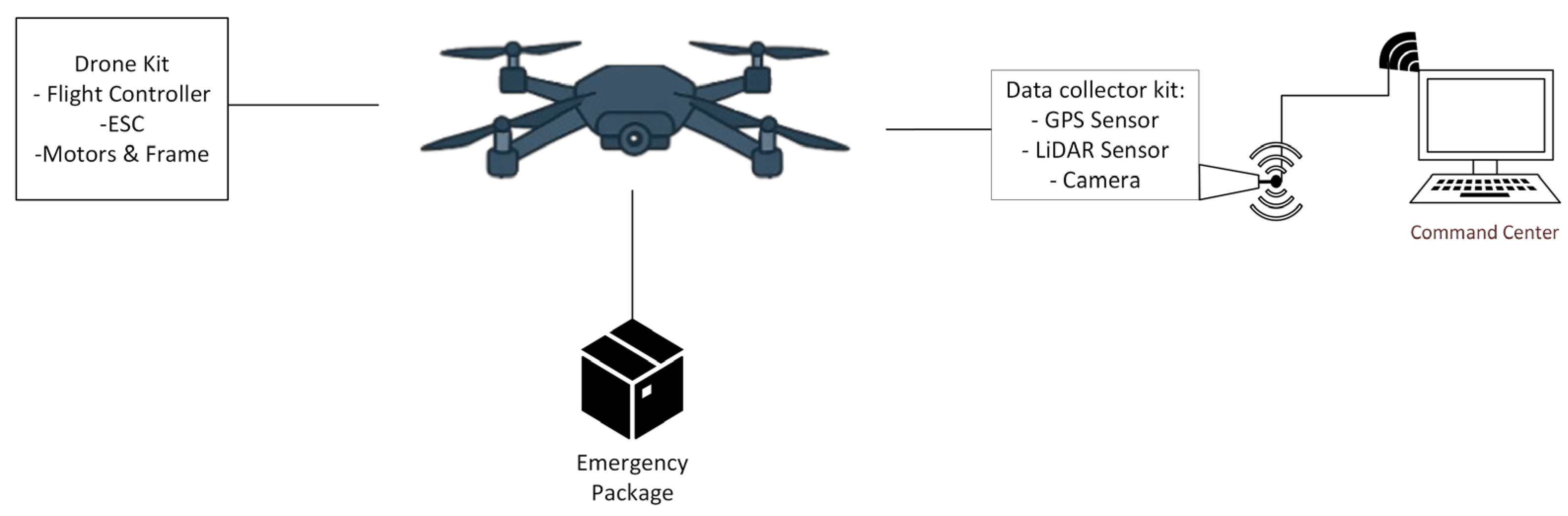
Figure 2.
Assembled drone kit, without sensors attached.
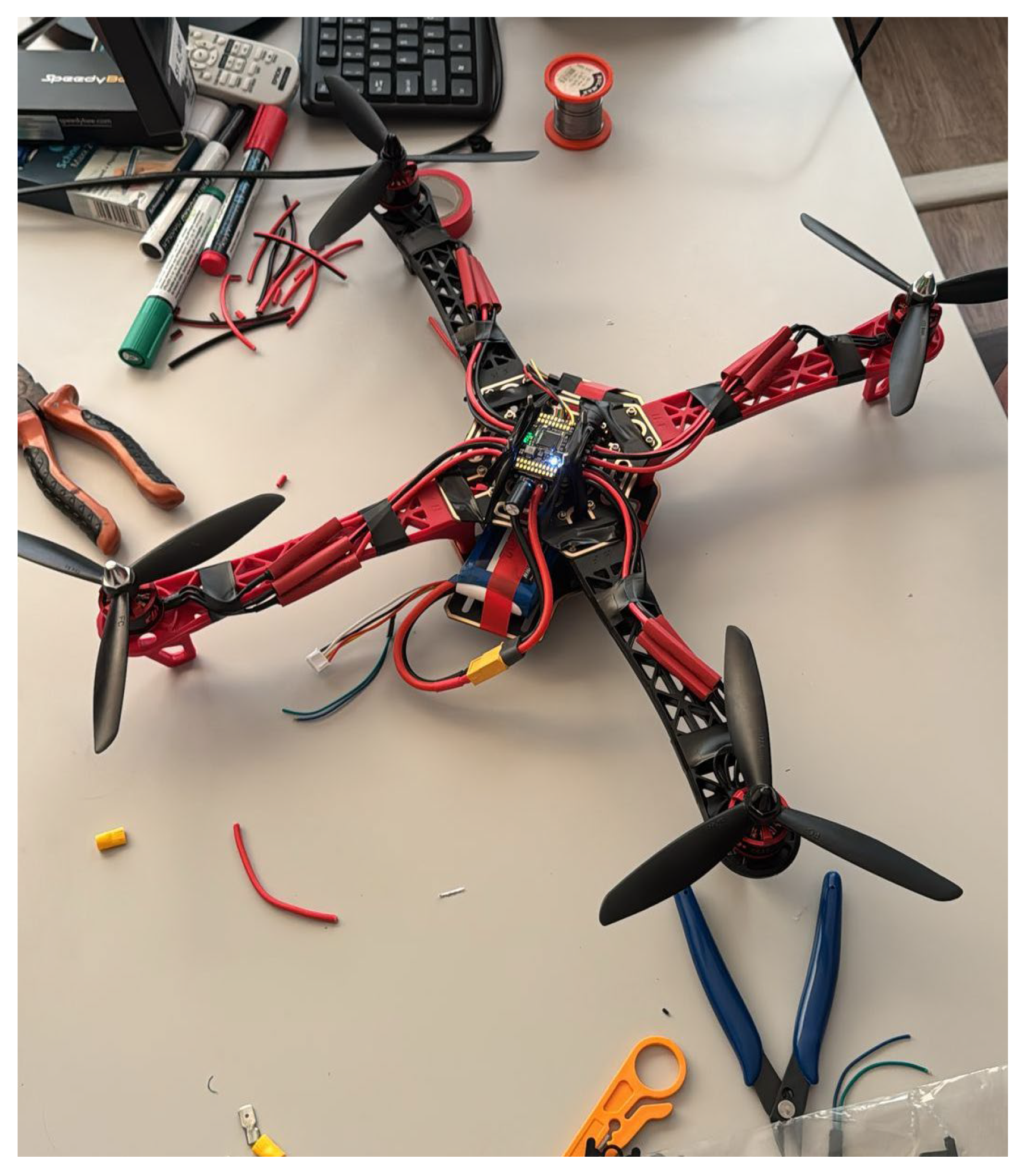
Figure 3.
Hardware system of the ESP32S3 with adjacent sensors.
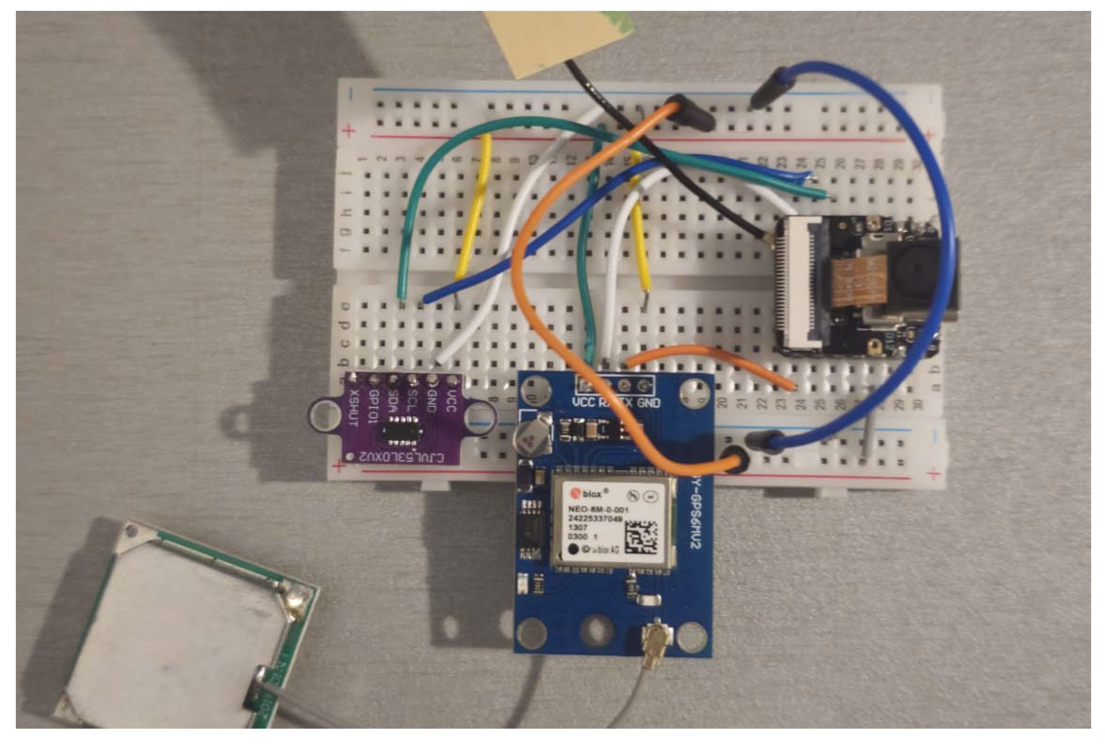
Figure 4.
Transport system of the package.
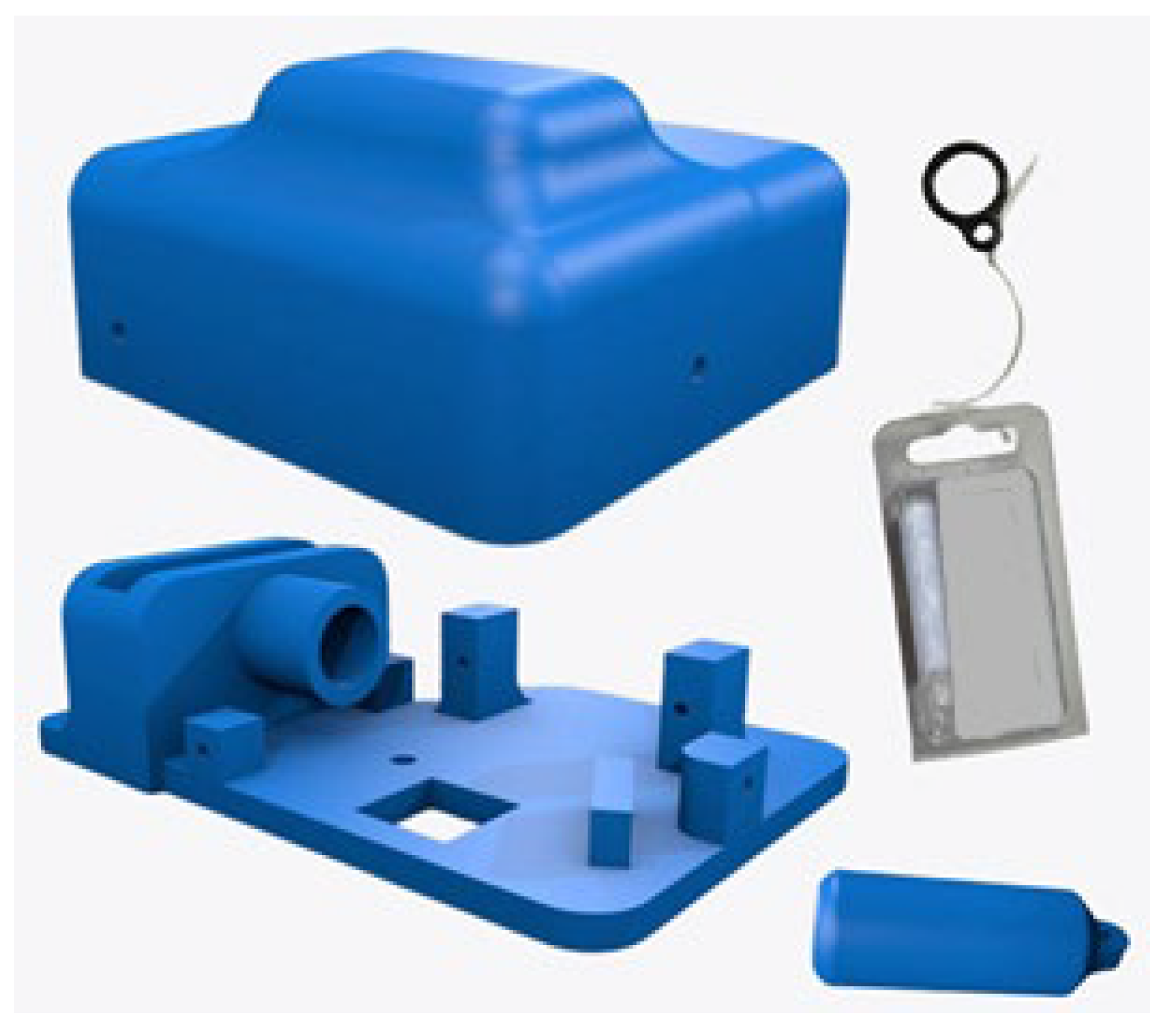
Figure 5.
Demonstration of the drone in flight with the delivery package.
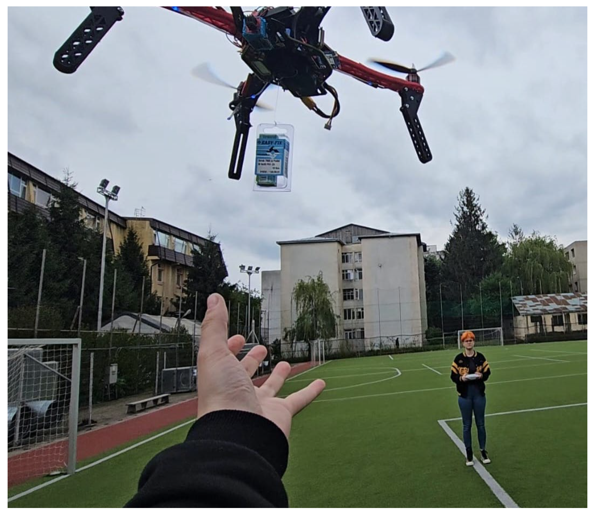
Figure 6.
The central application.
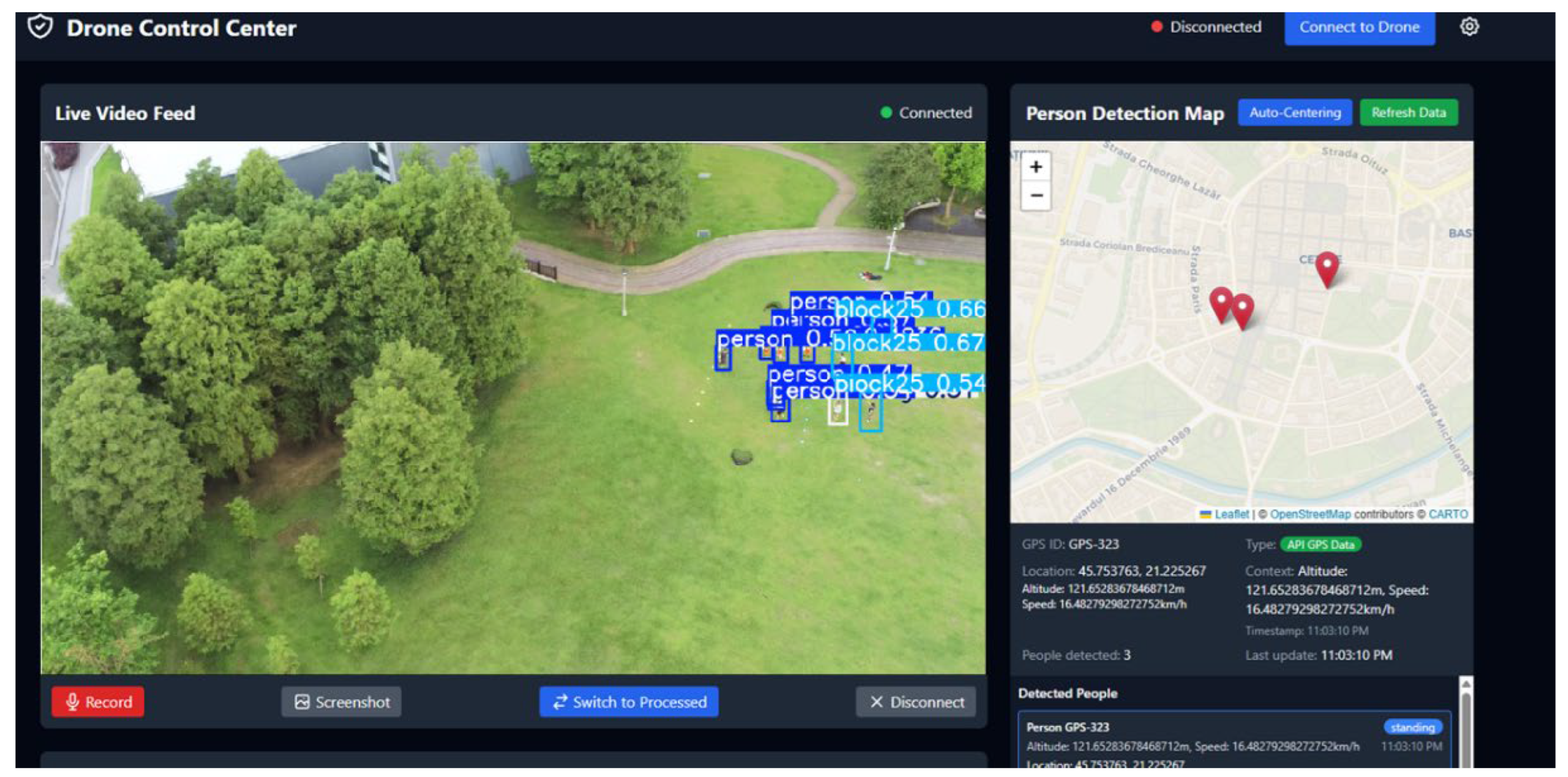
Figure 7.
Optimal hyperparameters determined following the evolutionary adjustment process.
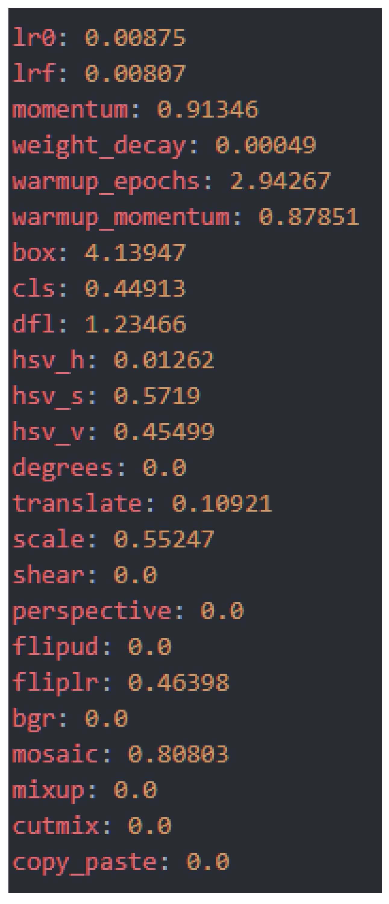
Figure 8.
Performance metrics.
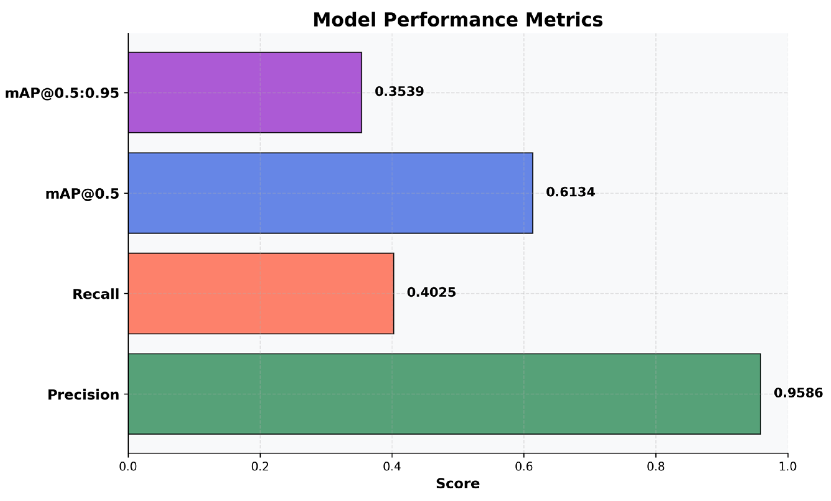
Figure 9.
Metrics ranking of all classes.
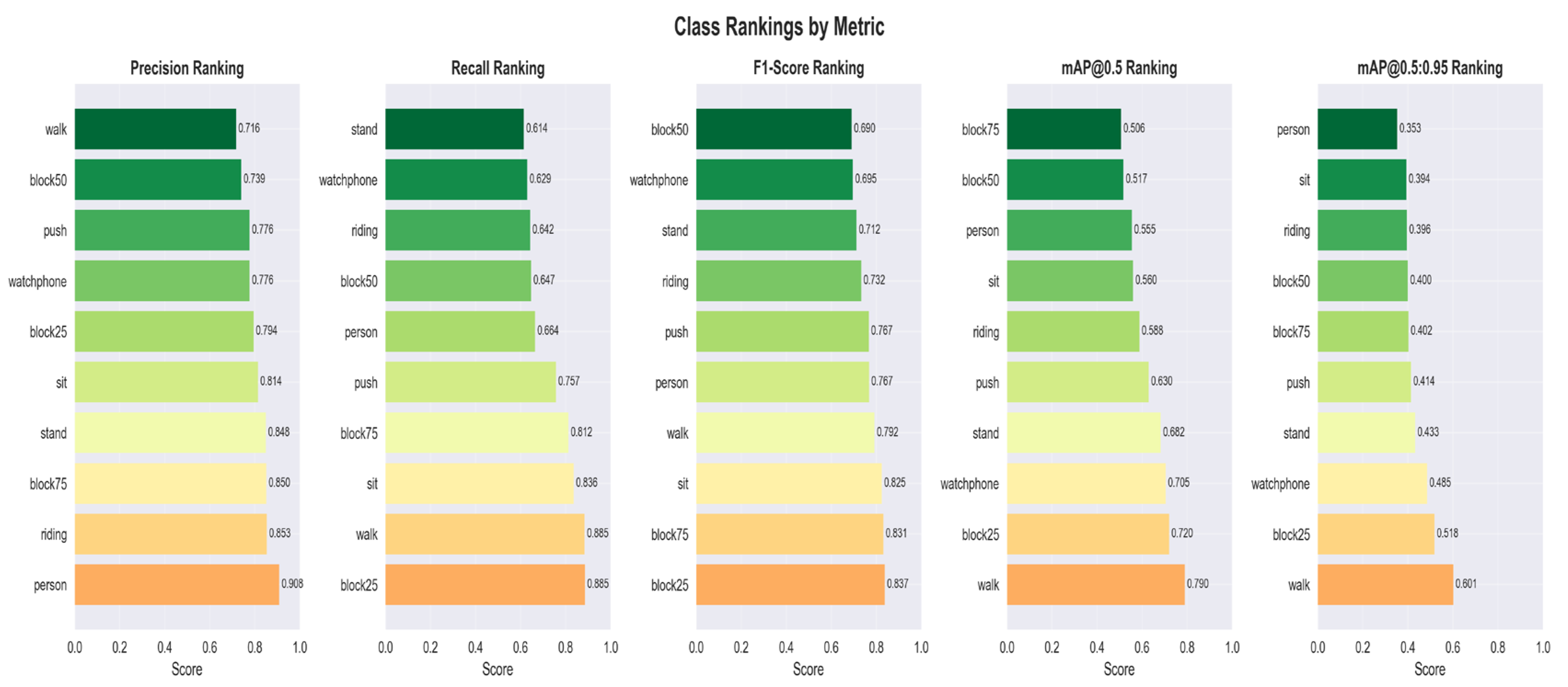
Figure 10.
Normalized Confusion Matrix of the YOLOv11l Model. The main diagonal represents the accuracy per class (Recall), and the values outside the diagonal indicate classification errors.
Figure 10.
Normalized Confusion Matrix of the YOLOv11l Model. The main diagonal represents the accuracy per class (Recall), and the values outside the diagonal indicate classification errors.
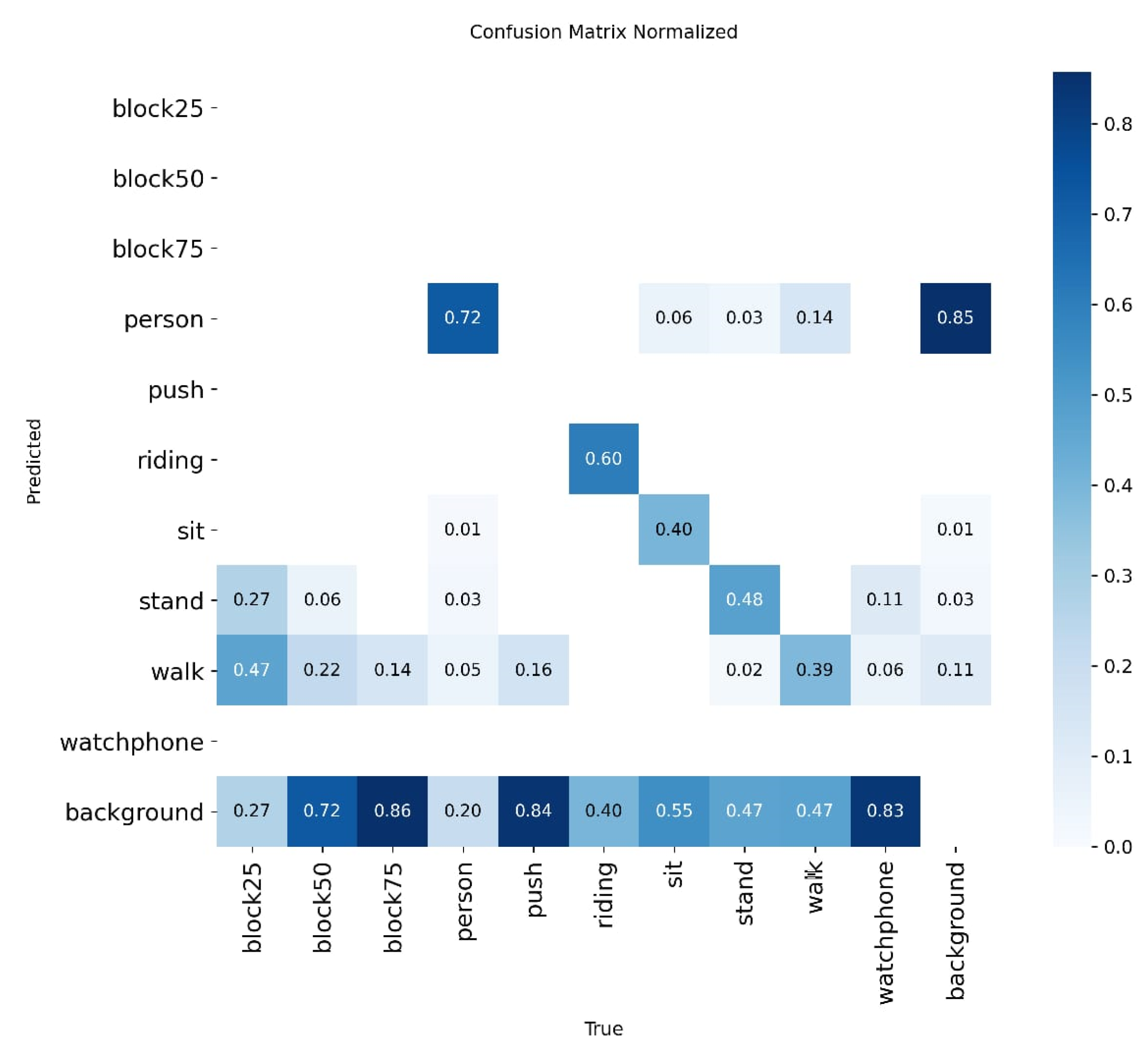
Figure 11.
Visual representation of the position estimation.
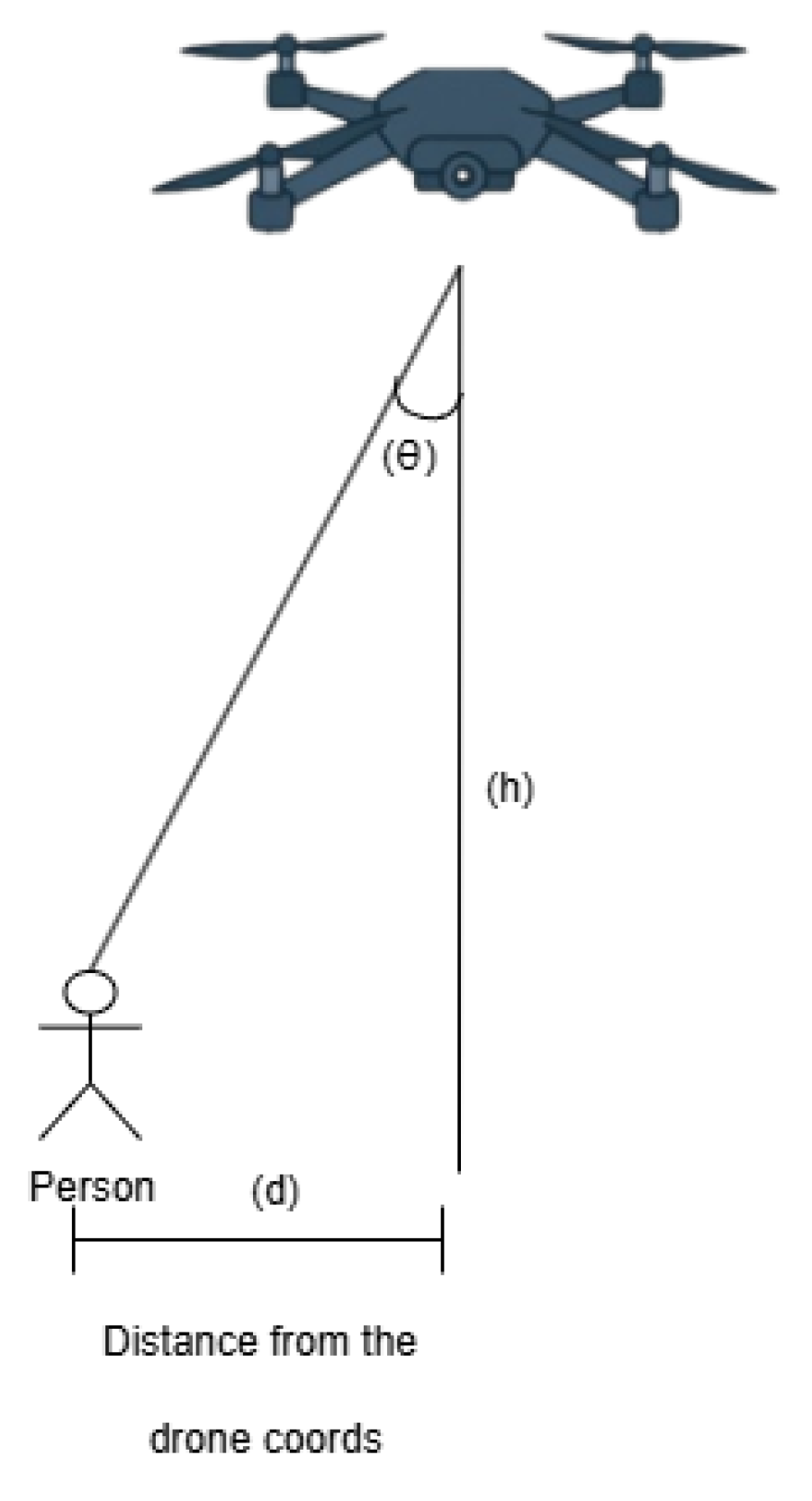
Figure 12.
Cognitive Recommendation Generation Unit.
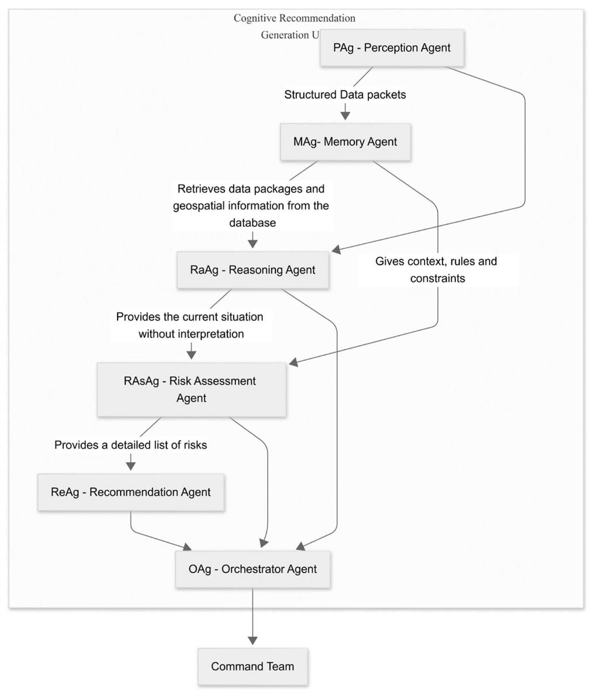
Figure 13.
Semantic structure resulted from RaAg.
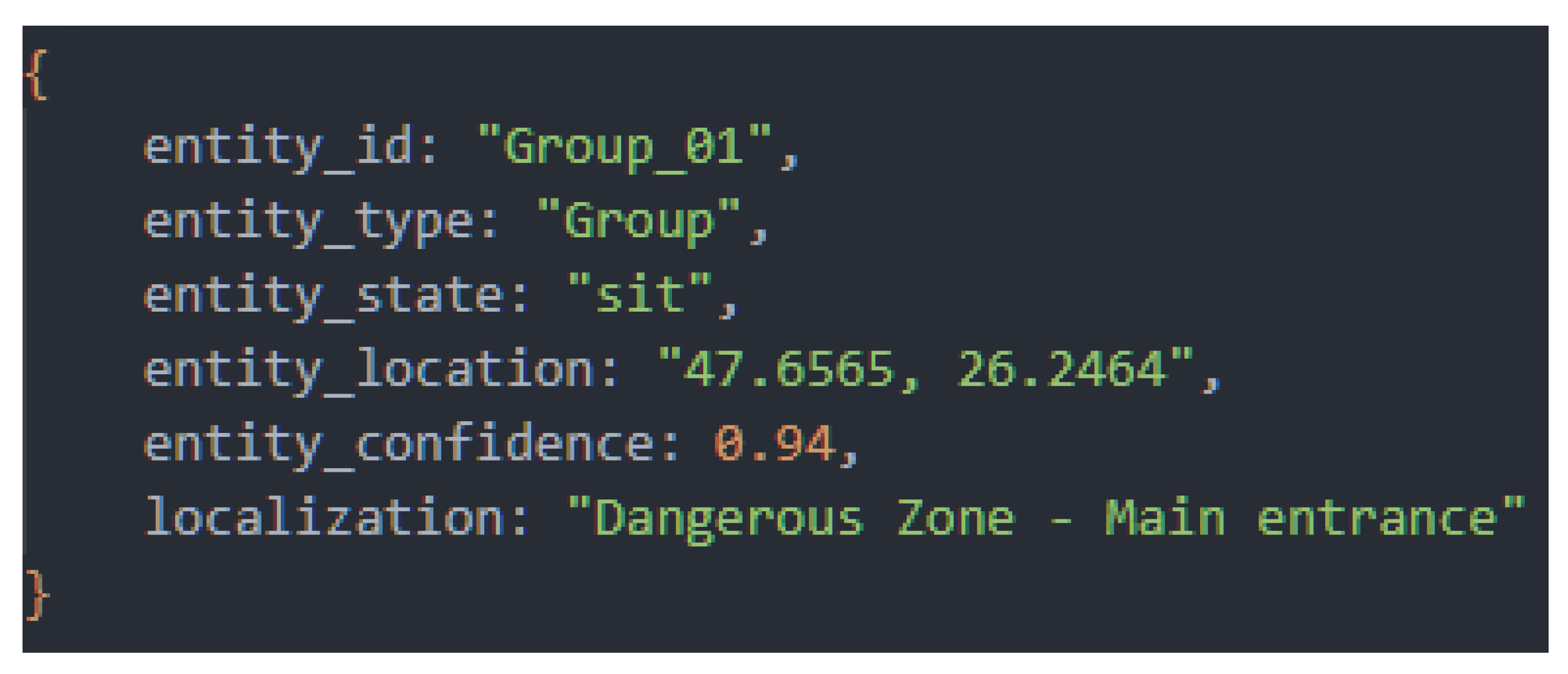
Figure 14.
Communication flow between agents.
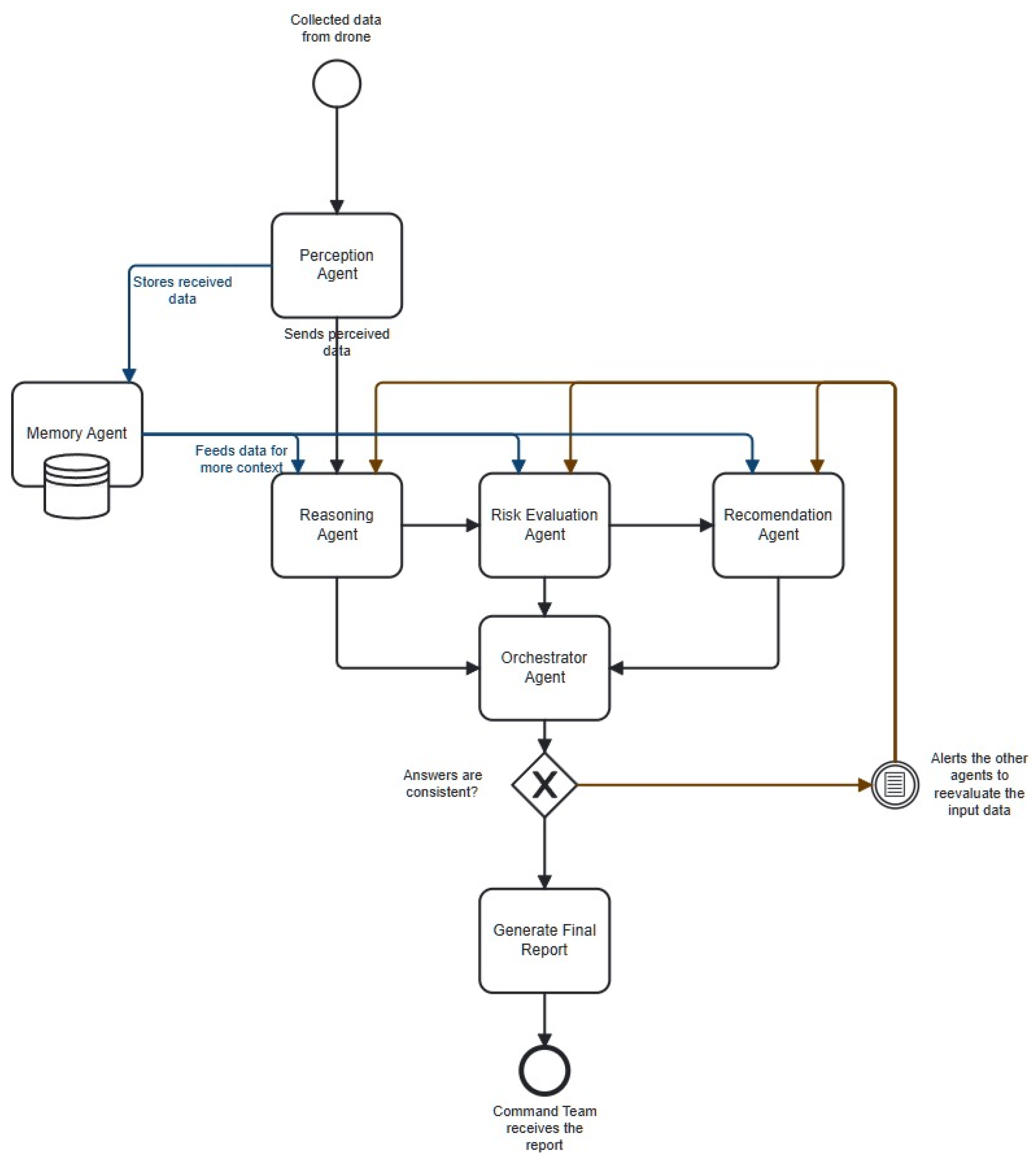
Figure 15.
Standardized data package generated by the Perception Agent (PAg). This structure serves as input for the entire cognitive pipeline.
Figure 15.
Standardized data package generated by the Perception Agent (PAg). This structure serves as input for the entire cognitive pipeline.
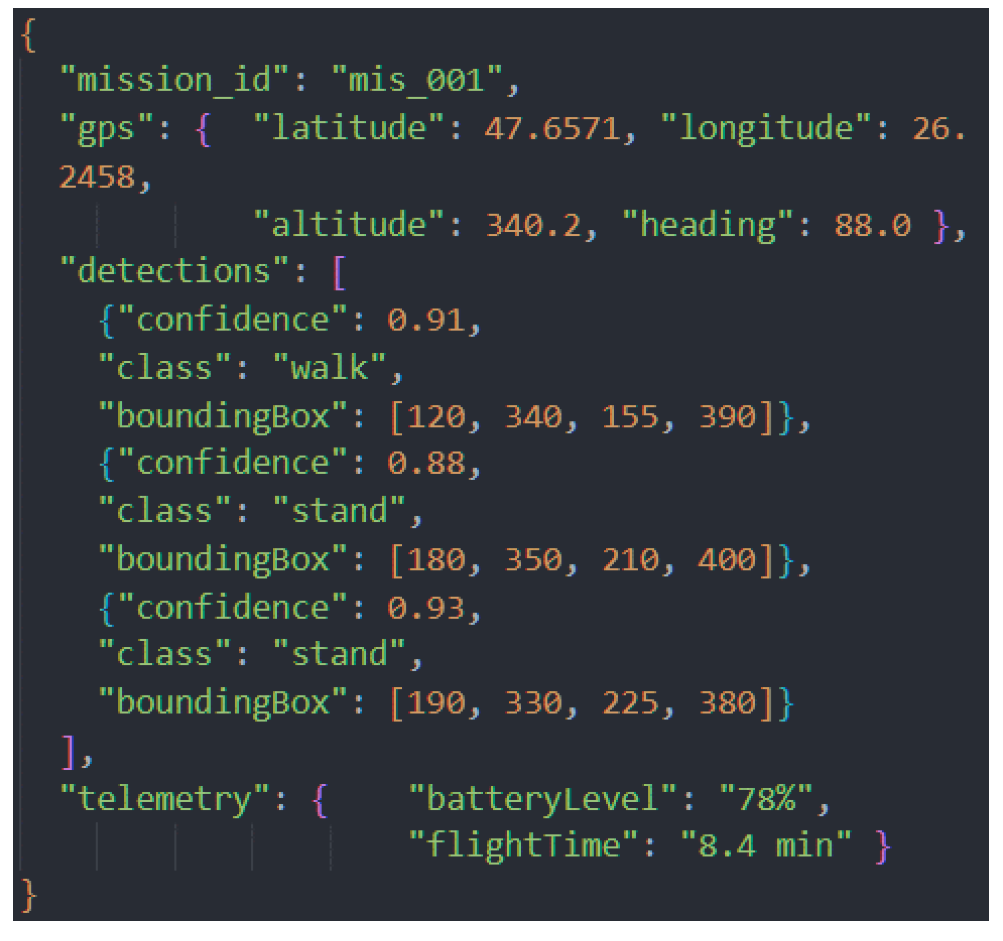
Figure 16.
Risk assessment report from the Risk Assessment Agent (RAsAg) for the low-risk scenario, showing a correct assessment and justification.
Figure 16.
Risk assessment report from the Risk Assessment Agent (RAsAg) for the low-risk scenario, showing a correct assessment and justification.
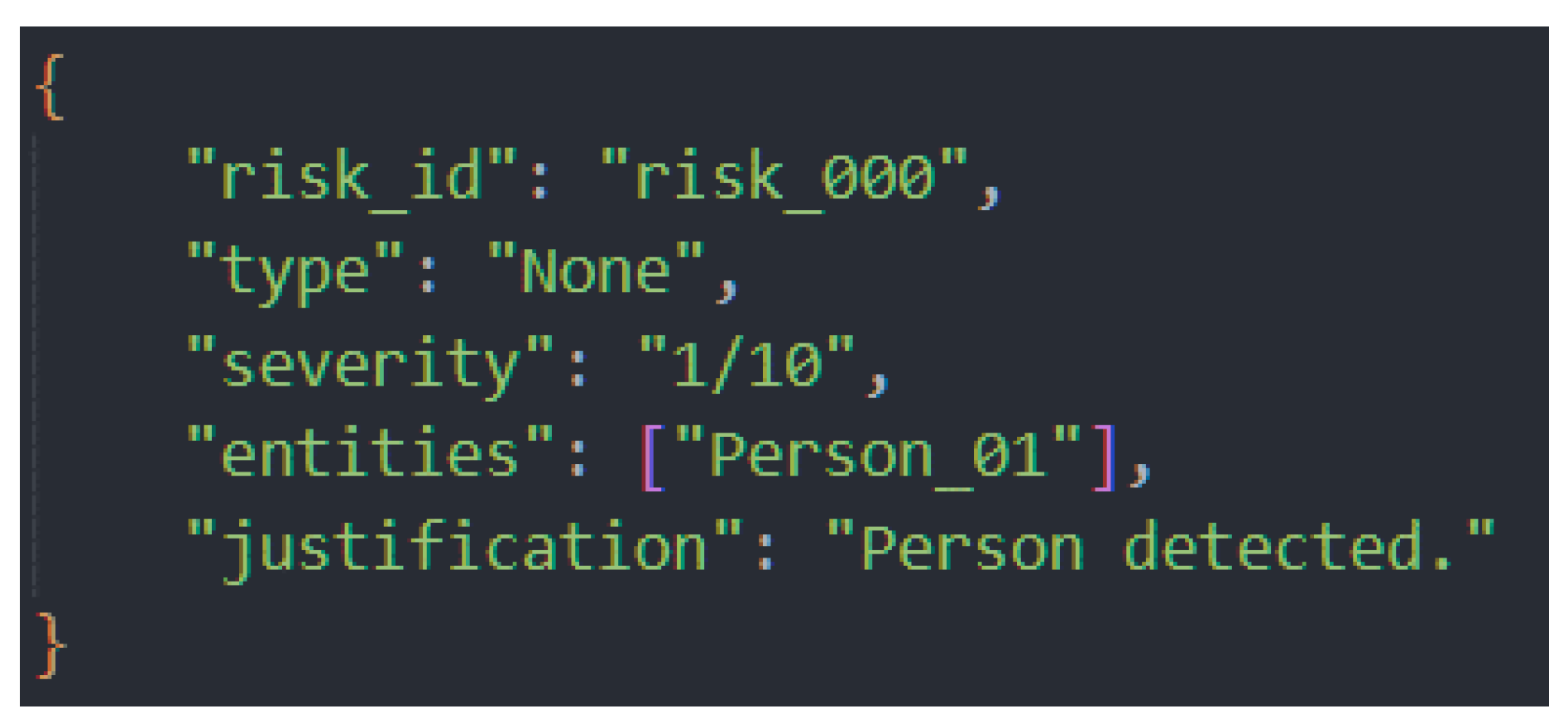
Figure 17.
Factual report from RaAg for the high-risk scenario, correctly contextualizing the detection as a maximum alert event based on temporal and spatial data from MAg.
Figure 17.
Factual report from RaAg for the high-risk scenario, correctly contextualizing the detection as a maximum alert event based on temporal and spatial data from MAg.
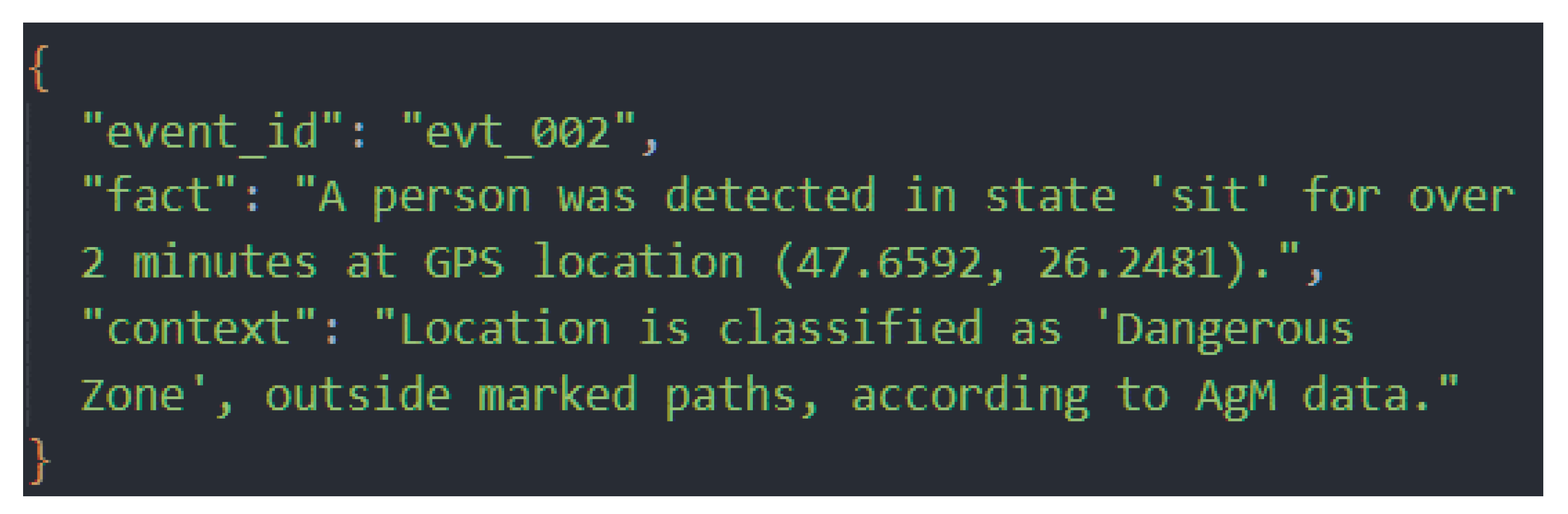
Figure 18.
The risk assessment report, in which the assessment error was introduced for testing purposes.
Figure 18.
The risk assessment report, in which the assessment error was introduced for testing purposes.
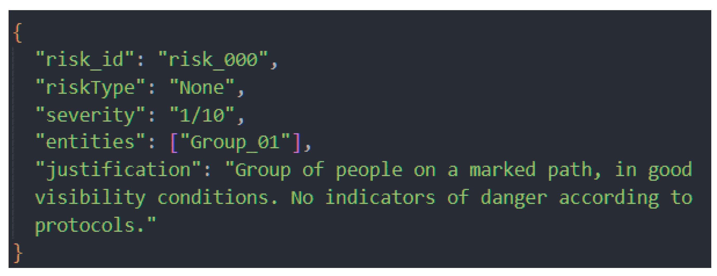

Table 1.
Comparison of technical parameters between the proposed UAV platform and two representative commercial systems.
Table 1.
Comparison of technical parameters between the proposed UAV platform and two representative commercial systems.
| Comparison criterion | The proposed drone | Fixed-wing VTOL UAV [19] | DJI Matrice 300 RTK ([20,21]) |
| Drone type | Custom-built multi-motor (quadcopter) | Fixed wing + VTOL | Multi-motor (quadcopter) |
| Payload (kg) | 0,5 – 1,0 (delivery module 0,3-0,7) | ~1,0 | 2,7 |
| Hardware configuration | 920 kv motors, 2650 mAh LiPo battery, STM32F405 flight controller, camera sensors, LiDAR, GPS | Electric motor with propulsion propeller + VTOL lift propeller, Li-Po batteries | Coaxial electric motors, compatible with Zenmuse P1/L1 sensors |
| Autonomy (min) | 12-15 | 90 (up to 4-10 hours in extended configurations) | 55 |
| AI capabilities | YOLO11 + cognitive-agentic architecture (LLM) | Autonomous routing and position maintenance systems in hover-forward transitions | Integrated AI functions for mapping and automatic inspection |
| Maximum range (km) | 0,5-1,0 | 50-200 | 15 |
Table 2.
Example of formalized rules in the risk knowledge base.
| Rule_ID | Severity | Condition | Action |
| R-MED-01 | 10 | Sudden Collapse: An abrupt change from an active to an inactive state. | Immediately transmit coordinates to the SAR team. Switch drone to ‘hover’ mode for monitoring. |
| R-MED-02 | 9 | Critical Inactivity: A person in a vulnerable position for an extended period. | Prepare first-aid package delivery. Mark victim on GCS map. |
| R-ENV-01 | 8 | Environmental Hazard: A person located in a known natural danger zone. | Mark danger zone on GCS map. Plan safe extraction route. Notify operator about zonal hazard. |
| R-BHV-01 | 7 | Mass Evacuation: Coordinated fleeing behavior of a group. | Monitor group’s flee path. Scan origin area to identify the source of danger. Notify operator about the unusual group event. |
| R-VUL-01 | 8 | Trapped Victim: High occlusion and prolonged inactivity suggest entrapment. | Initiate proximity scan with LiDAR. Mark point of interest for ground investigation. Alert operator about possible entrapment. |
Table 3.
Summary of Cognitive Performance Metrics in Test Scenarios.
| Cognitive Metrics | Scenario 1 (Low Risk) | Scenario 2 (High Risk) | Scenario 3 (With Forced Error) |
| Total decision time (seconds) | 11 | 14 | 18 |
| Accuracy Risk Assessment | Correct (1/10) | Correct (9/10) | Initially incorrect, corrected onto 9/10 |
| Auto-Correct Success | N/A | N/A | YES |
| Long-Term Memory Calls (MAg) | 1 | 2 | 3 |
| Fidelity Final Report vs. Situation | High | High | High (after correction) |
Disclaimer/Publisher’s Note: The statements, opinions and data contained in all publications are solely those of the individual author(s) and contributor(s) and not of MDPI and/or the editor(s). MDPI and/or the editor(s) disclaim responsibility for any injury to people or property resulting from any ideas, methods, instructions or products referred to in the content. |
© 2025 by the authors. Licensee MDPI, Basel, Switzerland. This article is an open access article distributed under the terms and conditions of the Creative Commons Attribution (CC BY) license (http://creativecommons.org/licenses/by/4.0/).
Copyright: This open access article is published under a Creative Commons CC BY 4.0 license, which permit the free download, distribution, and reuse, provided that the author and preprint are cited in any reuse.


