Submitted:
29 July 2025
Posted:
30 July 2025
You are already at the latest version
Abstract
Effective forest planning in Mediterranean environments requires integrated tools capable of managing ecological complexity, topographic variability, and institutional fragmenta-tion. This study presents a Geographic Information System (GIS)-based methodological framework for territorial forest planning, applied to the “Bosco della Ficuzza, Rocca Busambra, Bosco del Cappelliere, Gorgo del Drago” Regional Nature Reserve in Sicily, It-aly. The approach combines high-resolution cartography, digital terrain modeling, and Global Navigation Satellite System (GNSS) surveys to create a multi-layered Territorial Information System (TIS) that supports spatial decision-making in protected areas. A de-tailed Digital Terrain Model (DTM) was generated using a Triangulated Irregular Network (TIN) approach to derive key topographic attributes including slope, aspect, and elevation classes. Field surveys of forest roads and infrastructure were conducted using consum-er-grade GNSS receivers to assess network condition and accessibility. The resulting geo-database integrates vector and raster data, supporting thematic analyses such as fire ex-posure zoning, infrastructure prioritization, and accessibility modelling. The proposed framework enables scalable, cost-effective planning and is aligned with INSPIRE Directive standards to ensuring interoperability with broader European spatial data infrastructures. Its replicability and adaptability make it suitable for application in other Mediterranean forest landscapes. The study emphasizes the significance of digital tools for enhancing forest governance, increasing transparency, and supporting adaptive management in en-vironmentally sensitive areas.
Keywords:
GIS-based forest planning
; Territorial Information System (TIS)
; Digital Terrain Model (DTM)
; Forest road network
; GNSS survey
; Mediterranean forest
; Protected areas
; Sustainable forest management
1. Introduction
Mediterranean forest ecosystems are complex socio-ecological systems that provide a wide array of ecosystem services, including timber and fuelwood provisioning, carbon sequestration, water regulation, erosion control, biodiversity conservation, and recreational opportunities [1,2]. These landscapes have been shaped by centuries of human interaction, resulting in a delicate balance between ecological integrity and socio-economic use. In recent decades, forest planning paradigms have evolved from extractive, timber-centric models to more integrated approaches that encompass the multifunctionality of forest landscapes. This transition emphasizes biodiversity conservation, ecosystem service valuation, risk mitigation, and stakeholder engagement as essential pillars of sustainable forest management [3].
This shift is particularly significant in Mediterranean regions such as Sicily, where forest ecosystems are ecologically sensitive and face overlapping administrative governance complexities and socio-economic pressures. Here, forest planning must reconcile natural conservation objectives with fragmented land tenure, competing land uses, and vulnerability to climate change impacts such as drought and wildfires [4]. These conditions underscore the critical need for spatially explicit, data-driven tools to support forest planning and decision making.
Geographic Information Systems (GIS) and Global Navigation Satellite Systems (GNSS) have emerged as foundational technologies in modern forest management, enabling planners and decision-makers to address these complexities. GIS platforms facilitate the acquisition, integration, and spatial analysis of diverse datasets, facilitating scenario modelling, monitoring of landscape changes, and optimization of silvicultural and conservation strategies [5,6,7,8,9,10]. Complementary to GIS, GNSS technologies enable precise georeferencing of ecological features and infrastructure, thereby enhancing the accuracy of field data collection and facilitating real-time spatial decision-making [11]. Together, these tools form the backbone of precision forest planning, offering the potential to transition from static, paper-based plans to dynamic, adaptive spatial decision support systems. In Italy, forest governance is highly decentralized, with regional administrations holding primary authority over environmental planning and resource management. This federalist structure has led to a mosaic of forest planning instruments and operational practices across the national territory [12]. Within this regulatory environment, regional nature reserves serve a strategic purpose as testing sites for the development and implementation of innovative forest management methods. These protected areas, often located in mountainous and biodiversity-rich regions, provide ideal environments for testing integrated planning frameworks that can later be adapted for use in other forest landscapes.
This study proposes a GIS and GNSS-based methodological framework for territorial forest planning, applied to the case study of the “Bosco della Ficuzza, Rocca Busambra, Bosco del Cappelliere, Gorgo del Drago” Regional Nature Reserve in western Sicily. This protected area, covering over 8,500 hectares, constitutes one of the most important biodiversity hotspots in the Mediterranean basin and serves as a vital reference area for forest ecology and conservation science [13]. The main objective of this research is to develop a scalable and operational spatial information system tailored to the governance challenges of Mediterranean protected forests. This system aims to support key forest planning functions, including infrastructure management, environmental monitoring, fire risk mitigation, and participatory decision-making.
The proposed methodological approach integrates high-resolution topographic data, thematic cartography, and GNSS-based surveys of roads and infrastructure. These components are analyzed within a GIS-based framework. Together, they support the digitalization of environmental planning and contribute to current research in this field. The study also introduces a replicable and adaptable model for forest landscapes in other Mediterranean contexts that face similar ecological and governance challenges.
2. Materials and Methods
2.1. Study Area
The present study was carried out within the “Bosco della Ficuzza, Rocca Busambra, Bosco del Cappelliere, Gorgo del Drago” Regional Nature Reserve, situated in the western sector of the Sicilian Apennines, Italy (Figure 1). This protected area spans approximately 7,398 hectares and falls under the administrative jurisdiction of six municipalities within the Metropolitan City of Palermo. The reserve is distinguished by its highly varied topography, with elevations ranging from 400 to 1,613 m above sea level, and by its rich mosaic of habitats, including oak-dominated woodlands, Mediterranean shrublands, wetland systems, and rocky outcrops. Ecologically, the reserve is one of the principal biodiversity hotspots in the Mediterranean Basin and forms part of the Natura 2000 network (Site Code ITA020010), underscoring its importance for European conservation efforts. A predominance of native broadleaved species, such as Quercus ilex L., Quercus pubescens Willd, Fraxinus ornus L., and Castanea sativa Mill., characterizes the forest composition. In addition, reforestation initiatives carried out during the mid-20th century introduced stands of Pinus nigra J.F.Arnold and Cedrus atlantica Endl., reflecting the historical management practices aimed at afforestation and soil protection [13].
Beyond its ecological importance, the reserve holds significant cultural and hydro-logical significance, shaping the local landscape identity and regulating water resources. Consequently, the area undergoes strict conservation and planning measures overseen by the Forestry Department of the Sicilian Regional Government. These management efforts aim to maintain biodiversity, protect the landscape, and support sustainable resource use, in accordance with regional environmental policies and European Union directives.
Inside the area there is a small village that developed near the Real Casina di Ficuzza. A royal site built starting from 1799 as a court residence to satisfy the hunting passion of Ferdinand IV King of Naples and Sicily.
2.2. Cartographic and Geospatial Data Sources
The development of a geospatial support system for forest planning in the study area involved integrating various cartographic, topographic, and remote sensing data within a GIS environment. The core spatial datasets consisted of both vector and raster formats, enabling the creation of a multi-layered Territorial Information System (TIS) capable of supporting spatial analyses relevant to forest governance.
The primary base layers were derived from the numerical Regional Technical Map (CTR) at a scale of 1:10,000, which provided detailed vector information on hydrology, transportation networks, land use classes, and topographic contours lines. To complement and verify these data, topographic maps produced by the Italian Military Geographical Institute (IGM)[14] at a scale of 1:25,000 were utilized. These legacy maps offered an essential reference for cross-validating road alignments and elevation features, ensuring historical continuity in the spatial representation of the landscape. High-resolution orthophotos from TerraItaly IT2000, with a spatial resolution of 1 m, along with aerial imagery from AGEA (Italian National Paying Agency), were employed to enhance the fine-scale interpretation of vegetation cover and anthropogenic structures. These remote sensing products enabled for the detailed classification of land cover types and the identification of infrastructure elements that were not readily apparent in vector datasets.
A Digital Terrain Model (DTM) was generated from digitized contour lines and spot height measurements, following a Triangulated Irregular Network (TIN) approach (Figure 1). This method, widely recognized in the spatial modeling literature [15,16], enabled the accurate reconstruction of the area’s complex topography and served as the foundation for deriving critical terrain attributes such as slope gradients, aspect orientations, and elevation zones. To ensure full interoperability with national geodetic frameworks and compliance with official Italian cartographic standards, all geospatial datasets were harmonized using the Gauss-Boaga projection (EPSG:9067: European Terrestrial Reference Frame 2000, Datum: ETRF2000). This step was fundamental to aligning the project outputs with regional and national spatial data infrastructures, facilitating future data sharing and integration in line with INSPIRE Directive (European Commission, 2007) [17], requirements.
2.3. GIS and Spatial Analysis Workflow
The GIS-based workflow used in this study was carried out with ArcGIS Desktop 10.8 (Esri Inc.), combining both vector and raster data processing to aid forest planning activities in the reserve. The process started with the digitizing and georeferencing of topographic features from scanned IGM maps and high-resolution orthophotos. This step ensured the alignment of legacy and current spatial information, enhancing the accuracy of the base cartographic layers.
Subsequently, a Digital Terrain Model (DTM) was created using the Triangulated Irregular Network (TIN) method within the ArcGIS 3D Analyst extension. This model served as the foundation for generating raster layers of key topographic variables, including slope, aspect, and elevation. These variables are widely recognized in the forestry literature as critical factors influencing forest suitability, accessibility, and ecological risk assessments [18]. The overall topographic processing workflow, from elevation data to terrain derivatives, is illustrated in Figure 2. Once generated, the terrain layers were analysed using zonal classification techniques to delineate management units. Slope classes were defined as <15°, 15–30°, and >30°, corresponding to standard operational thresholds for silvicultural feasibility and erosion risk. Aspect orientations and elevation bands were similarly classified to reflect differences in solar exposure, moisture regimes, and species distribution potential. These thematic layers were then integrated to support zoning for forest management prescriptions, fire prevention strategies, and conservation priorities.
The geospatial database structure was designed in accordance with the principles of the INSPIRE Directive, utilizing standardized naming conventions, topology rules, and metadata documentation to ensure long-term interoperability. The resulting database not only supported the analyses in this study and was also built for future updates, data sharing, and integration with broader regional and national spatial data infrastructures.
This workflow allowed the GIS platform to provide dynamic visualization and analysis of forest features, topography, and infrastructure networks, forming a strong spatial basis for adaptive forest management and decision-making within the protected area context.
2.4. Road Infrastructure Survey
A comprehensive inventory of the forest road network and associated infrastructure within the reserve was carried out through field surveys using a consumer-grade GNSS devices [19]. This approach enabled the accurate mapping of transportation assets crucial for forest management, fire prevention, and visitor access, while also evaluating the feasibility of using lower-cost technologies in operational forestry contexts.
Field data collection was conducted over three campaign periods, spanning from 2023 to 2025. For the survey of roads and various points of interest, an ArduSample (Andorra la Vella, Andorra) receiver based on a consumer-grade U-Blox ZED-F9P (Zurigo, Svizzera) chip was used, paired with a Samsung Galaxy Tab A9 tablet. Although based on low-cost components, the devices provided acceptable position accuracy, with average horizontal errors of ± <1.5 m in standalone mode and <0.9 m autonomously with SBAS coverage, even in forested or topographically shaded areas. This level of precision was deemed sufficient for mapping secondary and tertiary roads, where sub-meter accuracy was not required. These findings align with previous studies demonstrating the operational viability of low-cost GNSS systems in participatory mapping and resource-limited contexts [19,20,21]. In the tablet was installed with QField software (OPENGIS.ch GmbH, Laax, Switzerland) version 2.7, which enabled the direct acquisition of positional data and attribution of feature characteristics. Data were saved in shapefiles (.shp) format and later integrated into the geodatabase.
Each road segment and point of interest was classified according to a standardized coding system adapted from the FAO Forest Roads Manual [22]. Recorded attributes included road width, surface type, drainage condition, slope gradient, and structural integrity. In addition to linear road features, ancillary infrastructure such as access gates, water collection points, fire lookout stations, and scenic viewpoints were georeferenced and described (Table 1).
The collected spatial and attribute data were imported into the GIS environment, where they were structured within a topologically consistent geodatabase (Figure 3). This integration enabled the spatial querying of infrastructure based on condition, accessibility, and strategic importance. Furthermore, the road network was overlaid with slope and vegetation layers derived from the DTM, facilitating the assessment of accessibility constraints, maintenance priorities, and vulnerability to erosion and fire risk. The resulting infrastructure dataset serves as a foundational layer for forest operational planning, emergency response strategies, and the optimization of maintenance and restoration efforts within the protected area.
3. Results
The GIS-based methodological framework developed for this study allowed for the construction of a structured, and multi-thematic geospatial database supporting forest planning, infrastructure management, and environmental risk assessment within the Bosco della Ficuzza Regional Nature Reserve. The combination of terrain analysis, digital cartography, and field-based GNSS surveys produced a consistent set of outputs capable of informing spatially explicit decision-making processes. Figure 4 illustrates three key results derived from this integrated approach. Panel (a) shows the forest road network, classified into primary, secondary, tertiary roads, and overlaid on the terrain background within the boundaries of the nature reserve. Panel (b) presents the georeferenced locations of critical infrastructure and resource points, including water sources, lookout towers, barracks, and access structures, all essential for forest operations and fire prevention planning. Panel (c) provides a 3D elevation model of the area, with elevation bands to reflect topographic variability and support terrain-based analyses such as accessibility and erosion risk. Together, these outputs demonstrate the operational potential of a GIS- and GNSS-based system in developing comprehensive and adaptable forest management tools for protected Mediterranean landscapes.
3.1. Digital Terrain Model and Thematic Layers
A high-resolution DTM was generated using the TIN approach, based on digitized contour lines with a 10-m interval and geodetic benchmarks collected during the GPS surveys. The resulting DTM demonstrated strong vertical consistency, achieving a mean error approximately ±1.2 m.
From the DTM, several key topographic layers were derived, including slope, aspect, and elevation maps. The slope analysis showed that steep slopes (>30°) characterize more than 37% of the reserve’s surface area, highlighting significant constraints on accessibility, erosion risk, and fire management. Aspect analysis indicated a predominance of south-facing slopes, with account for about 42% of the total area. These slopes, more exposed to solar radiation, represent critical zones in terms of fire risk and water stress, requiring targeted silvicultural interventions and conservation strategies. Elevation was classified into five altitudinal zones: less than 600 m (27% of the area), 600–800 m (35%), 800–1,000 m (25%), 1,000–1,200 m (11%), and above 1,200 m (2%). This stratification supports habitat characterization, forest typology zoning, and the design of altitudinally adapted management prescriptions.
The integration of these topographic layers with land use and vegetation data enabled for the delineation of forest compartments and management units tailored to the biophysical variability of the reserve.
3.2. Forest Road Inventory and Accessibility Analysis
The field surveys resulted in the comprehensive mapping and classification of 173 road segments, encompassing approximately 284 km of linear infrastructure within the reserve. The road network was classified into three functional categories based on the role and structural characteristics of each segment. The first category includes the primary access roads, which represent 19% of the total network and serve as the main transportation corridors. The second category consists of secondary forest roads, accounting for about 37% of the network. These routes provide access to key forest management areas and are essential for routine silvicultural operations. The third category comprises tertiary service tracks, covering 30% of the mapped infrastructure. These tracks are primarily used for operational and maintenance purposes. This classification system serves as the foundation for evaluating road accessibility of the reserve, identifying priority areas for road maintenance, and informing the planning emergency response strategies in the context of forest protection and risk mitigation. A summary of the distribution of road types, associated road elements, and critical infrastructure and resource features within the protected area is provided in Table 2. Beyond the linear road network, the survey georeferenced 192 points of infrastructure features critical to forest management and visitor use. These included access gates, bridges, fire lookout stations, water collection points, and panoramic viewpoints, etc. Each infrastructure element was systematically described and classified according to its structural condition, functional role, and level of integration within the reserve’s overall management framework, providing a spatially explicit inventory to support operational decision-making.
GNSS data accuracy evaluation demonstrated good performance of the ArduSample GNSS system, consistently achieving horizontal accuracy of approximately ±0.58 m and vertical accuracy of ±0.85 m. The receiver demonstrated acceptable levels of accuracy for general mapping purposes, with greater deviations observed in forested and topographically complex areas. These results are consistent with the findings of [20,21], who similarly documented the performance of consumer-grade GPS in environments characterized by canopy cover and variable terrain. Despite its limitations, the low-cost GNSS device proved to be operationally suitable for the mapping of secondary and tertiary roads, particularly in scenarios where financial or technical resources are constrained.
The spatial integration of the road network with terrain slope and vegetation cover data enabled the identification of critical accessibility constraints and areas requiring urgent maintenance. This analysis yielded valuable insights for prioritizing infrastructure upgrades and directly supported the formulation of fire prevention strategies and ecological plans within the reserve. The final output of the GIS workflow was a multi-layered geodatabase structured according to INSPIRE Directive principles, ensuring compliance with metadata and topology standards for spatial data management. This geodatabase incorporates vector layers representing roads, infrastructure elements, hydrography, hiking trails, vegetation units, and protected area boundaries, alongside raster layers depicting terrain attributes such as slope, aspect, and elevation.
The architecture of the TIS is designed to support advanced spatial querying, enabling users to filter road segments by slope class, evaluate accessibility in relation to road condition, and analyse the spatial overlap between vegetation types and topographic exposure. This analytical functionality provides a versatile foundation for a wide range of forest planning applications. Specifically, the system facilitates the optimization of fire service and maintenance routes through least-cost path analysis. It also supports the identification of forest compartments that require silvicultural interventions by overlaying analysis terrain data with ecological indicators. Additionally, it allows for the generation of accessibility heat maps, which help prioritize road maintenance activities and manage visitor circulation more effectively across the reserve.
3.3. Integration into a GIS-Based Territorial Information System
The final result of the methodological framework was the creation of a multi-layered GIS geodatabase, designed and organized according to INSPIRE-compliant metadata standards and topology rules. This geospatial database combines both vector and raster data, forming a reliable TIS capable that supports forest planning, infrastructure management, and environmental risk assessment within the reserve.
The vector layers include detailed representations of the road network, infrastructure elements, hydrography, hiking trails, vegetation polygons, and the delineation of protected area boundaries. Complementing these vector datasets, raster terrain models derived from the DTM provide continuous spatial coverage of key topographic attributes such as slope, aspect, and elevation. Each spatial feature is linked to attribute tables that enable advanced spatial queries, allowing users to filter data according to road condition, slope class, and infrastructure accessibility, thereby supporting targeted management interventions. The analytical capabilities of the geodatabase were demonstrated through several advanced spatial modeling applications. Least-cost path analysis was used to optimize the routing of fire service vehicles, ensuring quick access to high-risk areas while reducing exposure to difficult terrain. Overlay analysis combined topographic and vegetation data to identify forest compartments needing silvicultural interventions, helping prioritize management actions in areas most vulnerable to erosion, fire, or ecological stress. Additionally, accessibility heatmaps were created to visualize variations in road and infrastructure accessibility across the reserve, supporting strategic maintenance planning and informing visitors flow management.
The operational relevance and usability of the TIS were validated through a series of consultations with local forestry managers and reserve planners. Feedback from these stakeholders confirmed that the system addressed critical planning needs and provided a practical, scalable tool for improving spatial decision-making in the context of Mediterranean protected areas.
4. Discussion
The integration of GIS and GNSS into forest planning frameworks has emerged as a keydriver of spatially explicit, data-driven decision-making, particularly in ecologically sensitive and topographically complex Mediterranean environments. These technologies enable the transformation of fragmented spatial data into coherent information systems, supporting the analysis of terrain characteristics, infrastructure networks, and ecological constraints. The case study of the Bosco della Ficuzza Reserve illustrates how a structured geospatial methodology can facilitate the creation of a TIS that is not only multi-purpose—addressing silviculture, conservation, and fire prevention—but also multi-scale, adaptable to both site-specific interventions and broader landscape-level planning. Such systems are fundamental for advancing sustainable forest governance in protected areas, where competing environmental, social, and institutional factors must be reconciled through integrative and transparent planning processes.
4.1. Significance of Topographic and Terrain Analysis
Creating a high-resolution DTM was pivotal in deriving key topographic features - such as slope, aspect, and elevation - that critically inform spatial forest planning. These variables are not only key to understanding the landscape’s biophysical limitations but also essential for guiding management strategies related to fire prevention zoning, erosion risk reduction, and the placement of forest infrastructure. Terrain analysis provides the basis for predicting ecological vulnerabilities and operational challenges, allowing forest managers to develop targeted interventions that address site-specific conditions.
Comparable methodologies have been successfully applied in forest planning across mountainous regions of Europe and the Mediterranean, where steep and heterogeneous terrains present significant management complexities [23,24]. These studies consistently highlight the role of terrain modeling in supporting ecologically sensitive interventions, particularly in areas affected by soil erosion, wildfire risk, and biodiversity conservation pressures. In the Bosco della Ficuzza Reserve, terrain analysis revealed that more than 37% of the area is characterized by steep slopes exceeding 30%, which significantly limits mechanized access and increasing vulnerability to surface runoff and landslides. In addition, the predominance of south-facing slopes, covering approximately 42% of the reserve, exposes these areas to intense solar radiation and prolonged drought stress during the Mediterranean dry season. Such exposure conditions exacerbate fire risk and influence vegetation structure and species composition.
These findings are consistent with broader Mediterranean forest ecology literature, which underscores the role of terrain exposure and elevation gradients on species distribution, ecosystem resilience, and fire dynamics [25,26]. In this context, terrain-adapted silvicultural practices, including selective thinning, erosion control measures, and firebreak placement, are essential for crucial for enhancing forest resilience and reducing the vulnerability of steep, south-facing slopes.
4.2. Road Network Assessment and GNSS Applications
The systematic inventory and classification of the forest road network, carried out through GNSS-supported field surveys, established a reliable spatial baseline for infrastructure management and accessibility planning. The deployment of GNSS technology enables the precise mapping of critical infrastructure assets with centimeter-level accuracy, particularly valuable for documenting primary access routes and strategic service points. The study also demonstrates that consumer-grade GNSS devices, despite their lower positional accuracy, yielded results sufficiently robust for general road mapping tasks. This finding underscores the operational viability of low-cost geospatial technologies in supporting basic infrastructure surveys, especially in less critical areas or when budgetary constraints limit access to high-precision equipment.
The demonstrated performance of low-cost GNSS receivers reinforces their applicability in participatory mapping and community-based forest monitoring, where local stakeholders or non-specialist users can contribute to data collection with minimal technical barriers. This approach aligns with previous studies advocating for the democratization of geospatial data acquisition, particularly in resource-limited contexts [21,27]. In rural Sicilian landscapes, where public investment in forestry infrastructure is often limited, integrating open-source GIS platforms and affordable GNSS technologies represents a pragmatic pathway to expanding operational capacity and enhancing data-driven decision-making.
The road classification framework used in this study not only standardizes the categorization of road types based on their structural features and functional roles but also supports spatial querying and scenario analysis. When combined with terrain slope and vegetation cover data, this classification system allows for multi-criteria assessments of road maintenance needs and accessibility risks. These analyses help forest managers identify infrastructure segments that need urgent repairs, evaluate their vulnerability to erosion or blockage, and improve maintenance planning in relation to ecological sensitivity. This integrative approach is consistent with the emerging trend in European forest planning toward multi-criteria decision support systems (DSS), which aim to balance infrastructure functionality, ecological risk mitigation, and financial constraints in the formulation of forest management strategies [28,29]. The application of such systems in protected areas enhances the capacity for informed, transparent, and adaptive planning, particularly in landscapes where competing conservation and operational objectives exist.
4.3. Replicability and Scalability of the GIS-Based Framework
A central outcome of this study is the development of a modular and adaptable GIS-based methodology that can be readily replicated in other Mediterranean protected areas characterized by similar ecological and governance complexities. The geodatabase architecture, designed with a modular structure and compliant with the INSPIRE Directive’s interoperability standards [15,30], ensures the long-term usability, scalability, and integration of the system within broader spatial data infrastructures at the regional, national, and European levels. The flexibility of the TIS is further enhanced by its capacity to incorporate additional thematic layers beyond the core forestry and terrain data. Additional data layers, such as biodiversity monitoring datasets, fire regime histories, habitat suitability models, and tourism infrastructure inventories, can be seamlessly integrated into the system. This capacity extends the applicability of the framework beyond traditional forestry-focused planning toward a more holistic approach to land use management, supporting both conservation objectives and socio-economic development. The resulting multi-functionality positions the framework as a dynamic decision support tool, capable of addressing the interconnected challenges of protected area governance, sustainable tourism, and climate adaptation.
The replicability of this approach is particularly relevant in the context of European Union biodiversity policies and green infrastructure strategies, which emphasize spatial planning as a foundational element of sustainable land use management [30]. By aligning forest planning practices with these policy frameworks, local and regional authorities in Mediterranean landscapes such as Sicily, can enhance their eligibility for funding under European environmental programs, including LIFE+, Horizon Europe, and the European Green Deal. Furthermore, the methodological framework supports the implementation of ecosystem-based adaptation strategies, which encourage the use of spatially explicit planning tools to enhance the resilience of natural systems and local communities to climate change impacts [31]. Through its replicable structure and interoperability, the proposed GIS-TIS system offers a scalable platform for Mediterranean forest landscapes facing similar ecological pressures, institutional fragmentation, and socio-economic vulnerabilities.
4.4. Institutional Implications and Capacity Building
The successful implementation and long-term sustainability of a GIS-based Territorial Information System (TIS) are not solely dependent on technological robustness, but equally on institutional capacity, interdisciplinary collaboration, and the establishment of effective governance frameworks. While the technical architecture developed in this study provides a solid foundation, its long-termrelevance requires sustained investment in human capital. This includes specialized training in geospatial technologies, data management, and spatial analysis for forestry personnel and decision-makers.
Integrating the TIS into existing regional forest inventories and planning tools is vital to prevent fragmentation and ensure alignment with ongoing management efforts. Incor-porating the system into institutional workflows will promote its use as a routine plan-ning resource instead of a standalone technological solution. Additionally, establishing continuous feedback between the digital platform and on-the-ground forest management is essential for keeping spatial data up-to-date and reflective of real-world conditions. This ongoing process supports adaptive planning, allowing forest managers to improve strate-gies in response to shifting environmental conditions and operational challenges. In the context of the Bosco della Ficuzza Reserve, future advancements should prioritize the integration of biodiversity monitoring datasets, including indicators such as species richness, habitat quality, and ecological connectivity. Incorporating fire regime analyses, based on both historical and real-time fire data, would improve the system’s ability to support fire prevention and post-disturbance recovery planning. Equally important is encouraging stakeholder participation, which can be achieved through the development of WebGIS portals, open-access data platforms, and citizen science initiatives. These participatory tools would democratize access to spatial information, increase transparency, and empower local communities and stakeholders to contribute to forest governance.
By transitioning from a static mapping environment to a dynamic and participatory planning platform, the TIS can support a more inclusive and resilient approach to forest management. This change aligns with larger trends in environmental governance, em-phasizing the co-production of knowledge, collaborative decision-making, and the use of digital tools to boost transparency and accountability in protected area management.
5. Conclusions
This study introduces a GIS- and GNSS-based methodological framework aimed at supporting territorial forest planning in Mediterranean protected areas, with a specific application to the Bosco della Ficuzza Regional Nature Reserve in Sicily. By combining high-resolution terrain analysis, thematic mapping, and field-based infrastructure surveys, the research developed a multi-layered Territorial Information System (TIS) that enhances the spatial decision-making abilities of forest managers and planners.
The topographic analysis uncovered key landscape features, such as steep slopes, south-facing aspects, and elevation changes, that directly impact forest management priorities, including fire prevention, erosion control, and habitat preservation. The comprehensive inventory and classification of the forest road network, supported by both high-precision and low-cost GNSS technologies, proved the practical feasibility of scalable geospatial monitoring methods. Importantly, the use of consumer-grade GNSS receivers confirmed the potential for wider adoption of participatory and cost-effective data collection methods in resource- limited Mediterranean environments.
The resulting TIS is more than a repository of static maps, it functions as a dynamic planning tool capable of supporting zoning, infrastructure management, ecological risk assessment, and visitor management strategies. Its modular structure and compliance with INSPIRE interoperability standards ensure its adaptability to evolving management needs and its replicability in other Mediterranean forest landscapes. By facilitating advanced spatial analysis, such as least-cost path modeling and multi-criteria risk assessment, the system empowers managers to make informed, site-specific decisions that align with sustainable forest governance principles. From a policy perspective, the framework aligns with European Union strategies on biodiversity conservation and green infrastructure, supporting ecosystem-based adaptation and improving access to environmental funding programs such as LIFE+ and Horizon Europe. Its scalability and interoperability make it a replicable model for other protected areas facing similar ecological pressures and institutional challenges. Looking ahead, future developments should focus on integrating time-series environmental monitoring data, including fire history and land cover changes, to enable dynamic risk assessment and adaptive management. The evolution of the TIS into a participatory platform, through WebGIS tools and citizen science engagement, would further strenghthen its role in collaborative forest governance.
In conclusion, the proposed GIS-based methodological framework contributes to the digital transformation of forest planning in the Mediterranean region, offering a replicable, cost-effective, and operationally relevant approach to addressing the complex challenges of protected area management in ecologically sensitive and institutionally fragmented landscapes.
Author Contributions
“Conceptualization, C.G. and S.O.; methodology, P.C., M.V.F., G.M. and M.V.; software, S.O. and P.C.; validation, S.O., M.V.F., G.M. and M.V.; formal analysis, S.O. and C.G.; investigation, S.O., M.M.M. and M.V.; resources, S.O., M.M.M. and M.V.F.; data curation, P.C. and M.V.; writing—original draft preparation, S.O., C.G. and M.V.; writing—review and editing, S.O., P.C., G.M. and M.V.; visualization, M.V.F.; supervision, S.O., G.M. and P.C.; project administration, M.M.M. and M.V.; funding acquisition, M.M.M. All authors have read and agreed to the published version of the manuscript.”
Funding
The authors declare that financial support was received for the research and/or publication of this article. This research was funded by Convenzione GAL Rocca di Cerere Geopark/CREA DC dal Titolo: Valorizzazione di Specie Vegetali di Interesse Agroalimentare e Nutraceutico con Tecniche Innovative e sostenibili—Val. S. A N. I. S.—Cup: G78H23001250007.
Data Availability Statement
The original contributions presented in this study are included in the article. Further inquiries can be directed to the corresponding author upon reasonable request.
Conflicts of Interest
The authors declare no conflicts of interest.
References
- Tiebel, M.; Mölder, A.; Plieninger, T. Conservation Perspectives of Small-Scale Private Forest Owners in Europe: A Systematic Review. Ambio 2022, 51, 836–848. [Google Scholar] [CrossRef] [PubMed]
- Di Benedetto, S. Innovative Forest Multiscale Management and Planning: Modelling and Mapping Tools to Monitor Forest Ecosystems Functionality. 2018.
- Rye, T.; Wretstrand, A. Swedish and Scottish National Transport Policy and Spend: A Social Equity Analysis. Sustainability 2019, 11, 1894. [Google Scholar] [CrossRef]
- Nyamushosho, R.T.; Chirikure, S.; Sitas, A.; Maṱhoho, E.N. Modelling Land Use in the Gold Belt Territories of Iron Age Southern Zambezia. Land 2022, 11, 1425. [Google Scholar] [CrossRef]
- Sferlazza, S.; Maltese, A.; Ciraolo, G.; Dardanelli, G.; Maetzke, F.G.; La Mela Veca, D.S. Forest Accessibility, Madonie Mountains (Northern Sicily, Italy): Implementing a GIS Decision Support System. Journal of Maps 2021, 17, 476–485. [Google Scholar] [CrossRef]
- Pipitone, C.; Maltese, A.; Lo Brutto, M.; Dardanelli, G. A Review of Selected Applications of GNSS CORS and Related Experiences at the University of Palermo (Italy). Remote Sensing 2023, 15, 5343. [Google Scholar] [CrossRef]
- Civitarese, V.; Pignatti, G.; Verani, S.; Sperandio, G. Pianificazione Delle Operazioni Di Esbosco in Un Ceduo. Forest@-Journal of Silviculture and Forest Ecology 2006, 3, 367. [Google Scholar]
- Rogan, J.; Miller, J.; Wulder, M.; Franklin, S. Integrating GIS and Remotely Sensed Data for Mapping Forest Disturbance and Change. Understanding forest disturbance and spatial pattern: Remote sensing and GIS approaches. 2006, 133-172.
- Orlando, S. , Catania, P., Greco, C., Ferro, M. V., Vallone, M., & Scarascia Mugnozza, G. Rural Landscape Transformation and the Adaptive Reuse of Historical Agricultural Constructions in Bagheria (Sicily): A GIS-Based Approach to Territorial Planning and Representation. 17, 2025, 6291. Sustainability. [CrossRef]
- Orlando, S. , Greco, C., Tuttolomondo, T., Leto, C., Cammalleri, S., La Bella, S. Identification of Energy Hubs for the Exploitation of Residual Biomass in an Area of Western Sicily. 2017. 10.5071/25thEUBCE2017-1AO.7.5.
- Maimaitijiang, M. Multimodal Remote Sensing Data Fusion and Machine Learning for Crop Monitoring and Food Security. 2020.
- Di Letizia, G.; De Lucia, C.; Pazienza, P.; Cappelletti, G.M. Forest Bioeconomy at Regional Scale: A Systematic Literature Review and Future Policy Perspectives. Forest Policy and Economics 2023, 155, 103052. [Google Scholar] [CrossRef]
- Da Silveira Bueno, R.; LA MANTIA, T. Pattern e Driver Spaziali e Temporali Della Successione Secondaria in Un Pascolo Nelle Aree Aperte Della Riserva Naturale Di Ficuzza e Prospettive Di Gestione Del Paesaggio. In Pattern e driver spaziali e temporali della successione secondaria in un pascolo nelle aree aperte della Riserva Naturale di Ficuzza e prospettive di gestione del paesaggio; IT, 2021; pp. 9–9.
- IGM Istituto Geografico Militare 2025.
- Burrough, P.A.; McDonnell, R.A.; Lloyd, C.D. Principles of Geographical Information Systems; Oxford university press, 2015; ISBN 0-19-874284-3.
- Govers, G.; Giménez, R.; Van Oost, K. Rill Erosion: Exploring the Relationship between Experiments, Modelling and Field Observations. Earth-Science Reviews 2007, 84, 87–102. [Google Scholar] [CrossRef]
- Ogryzek, M.; Tarantino, E.; Rząsa, K. Infrastructure of the Spatial Information in the European Community (INSPIRE) Based on Examples of Italy and Poland. ISPRS International Journal of Geo-Information 2020, 9, 755. [Google Scholar] [CrossRef]
- Wilson, J.P.; Gallant, J.C. Terrain Analysis: Principles and Applications; John Wiley & Sons, 2000; ISBN 0-471-32188-5.
- Catania, P.; Comparetti, A.; Febo, P.; Morello, G.; Orlando, S.; Roma, E.; Vallone, M. Positioning Accuracy Comparison of GNSS Receivers Used for Mapping and Guidance of Agricultural Machines. Agronomy 2020, 10, 924. [Google Scholar] [CrossRef]
- Haklay, M.; Weber, P. Openstreetmap: User-Generated Street Maps. IEEE Pervasive computing 2008, 7, 12–18. [Google Scholar] [CrossRef]
- Zandbergen, P.A. Geocoding Quality and Implications for Spatial Analysis. Geography Compass 2009, 3, 647–680. [Google Scholar] [CrossRef]
- Heinimann, H. R. Forest road network and transportation engineering–state and perspectives. Croatian Journal of Forest Engineering: Journal for Theory and Application of Forestry Engineering, 38(2), 2017, 188-173.
- Rota, N. Evaluation of Ecosystem Services in Mountain Protected Areas: A Multi-Method Comparative Study. 2024.
- Gumus, S.; Acar, H.H.; Toksoy, D. Functional Forest Road Network Planning by Consideration of Environmental Impact Assessment for Wood Harvesting. Environmental monitoring and assessment 2008, 142, 109–116. [Google Scholar] [CrossRef] [PubMed]
- Moreira, F.; Viedma, O.; Arianoutsou, M.; Curt, T.; Koutsias, N.; Rigolot, E.; Barbati, A.; Corona, P.; Vaz, P.; Xanthopoulos, G. Landscape–Wildfire Interactions in Southern Europe: Implications for Landscape Management. Journal of environmental management 2011, 92, 2389–2402. [Google Scholar] [CrossRef] [PubMed]
- Borghi, C.; Chirici, G. Towards Biodiversity Conservation Goals: Remote Sensing and Ground-Based Data Applied to the Assessment of Forest Status. 2024.
- McCall, M.K.; Minang, P.A. Assessing Participatory GIS for Community-based Natural Resource Management: Claiming Community Forests in Cameroon. Geographical Journal 2005, 171, 340–356. [Google Scholar] [CrossRef]
- Bettinger, P.; Boston, K.; Siry, J.P.; Grebner, D.L. Forest Management and Planning; Academic press, 2016; ISBN 0-12-809706-X.
- Corona, P.; Chianucci, F.; Quatrini, V.; Civitarese, V.; Clementel, F.; Costa, C.; Floris, A.; Menesatti, P.; Puletti, N.; Sperandio, G. Precision Forestry: Riferimenti Concettuali, Strumenti e Prospettive Di Diffusione in Italia. Forest@-Journal of Silviculture and Forest Ecology 2017, 14, 1. [Google Scholar] [CrossRef]
- EEA Report European Environment Agency. State of Nature in the EU: Results from Reporting under the Nature Directives 2013–2018. 2020.
- Jokela, E.J. Forests: An International and Multi-Disciplinary Scientific Open Access Journal. Forests 2010, 1, 1–3. [Google Scholar] [CrossRef]
Figure 1.
Localization of study area: “Bosco della Ficuzza, Rocca Busambra, Bosco del Cappelliere, Gorgo del Drago” Regional Nature Reserve.
Figure 1.
Localization of study area: “Bosco della Ficuzza, Rocca Busambra, Bosco del Cappelliere, Gorgo del Drago” Regional Nature Reserve.
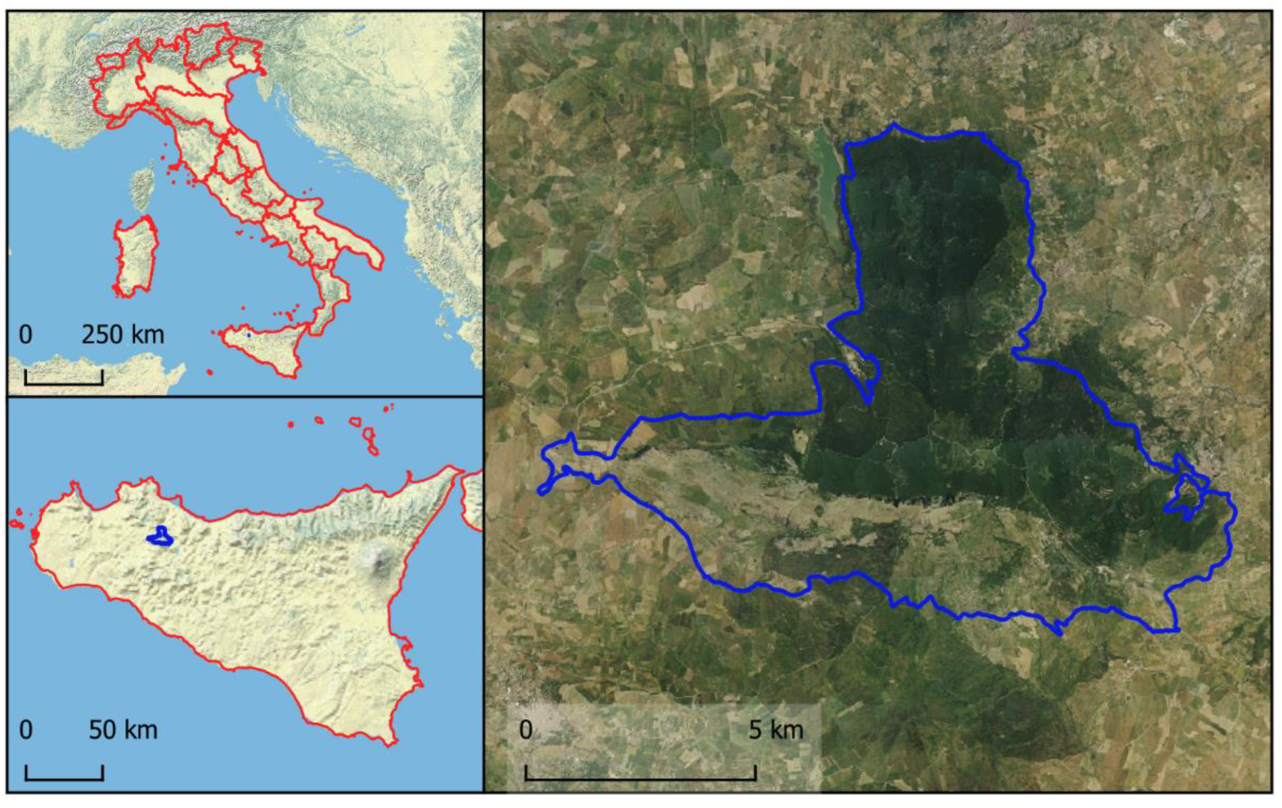
Figure 2.
Workflow for terrain modeling and topographic analysis. Starting from contour lines and elevation points (left), a 3D terrain model is generated (center), which is then used to derive key geomorphometric layers such as slope and aspect (right). These outputs support spatial analysis in environmental planning and landscape characterization.
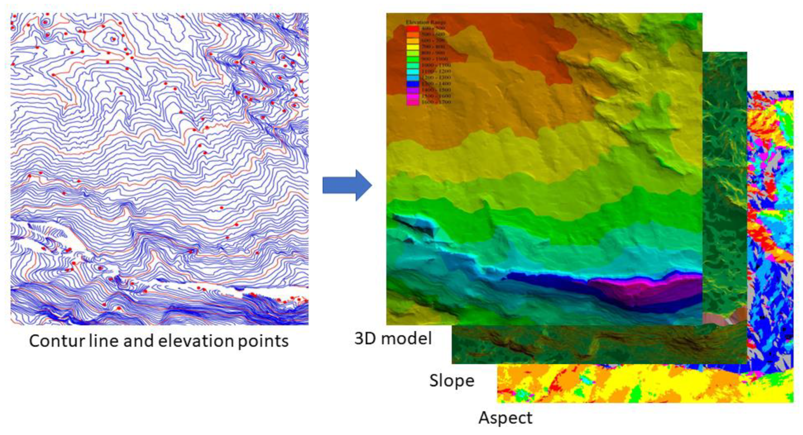
Figure 3.
Linear and point features surveyed via GNSS technology, with a schematic representation of the elements as visualized within a GIS environment.
Figure 3.
Linear and point features surveyed via GNSS technology, with a schematic representation of the elements as visualized within a GIS environment.
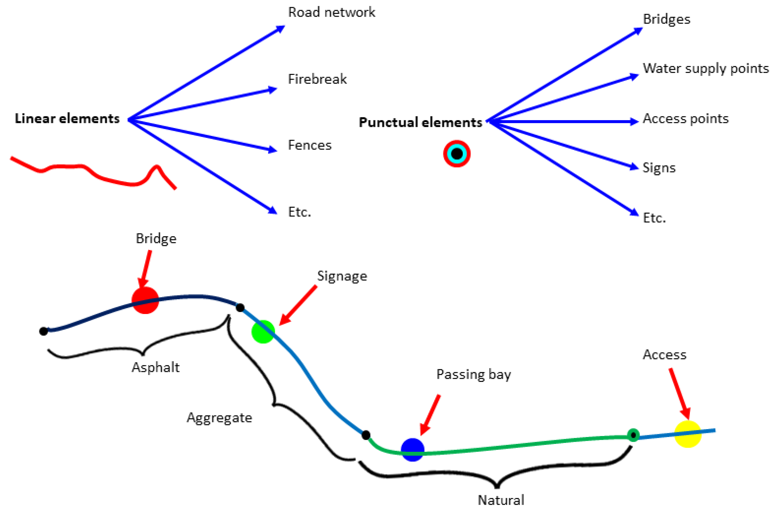
Figure 4.
Results of GIS-Based Forest Planning and Road Network Assessment in the Bosco della Ficuzza Reserve. Spatial and quantitative outputs from the GIS-based forest planning analysis in the “Bosco della Ficuzza, Rocca Busambra, Bosco del Cappelliere, Gorgo del Drago” Nature Reserve. (a) Road network map showing the classification of primary, secondary, and tertiary roads. (b) Location of major structures and resources, including bridges and milestones. (c) 3D altimetric map showing the altimetric distribution of the area, in which the Rocca Busambra massif (1,613 m above sea level) is clearly visible.
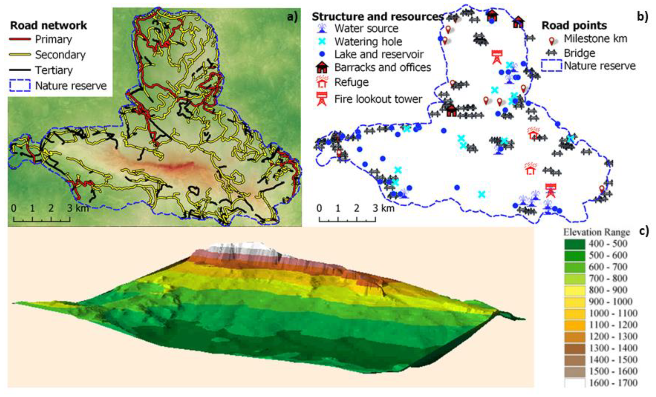

Table 1.
Attributes of features acquired during the field survey. The left section displays the parameters recorded for forest road infrastructures (linear features), while the right section presents a selection of surveyed point features along with their respective characteristics.
Table 1.
Attributes of features acquired during the field survey. The left section displays the parameters recorded for forest road infrastructures (linear features), while the right section presents a selection of surveyed point features along with their respective characteristics.
| Road network | Punctual element | ||||
|---|---|---|---|---|---|
| Parameter | Value | Element | Type | Condition | |
| Road surface | Asphalt | Bridge | Wood | Excellent Good Mediocre Poor |
|
| Aggregate | Concrete | ||||
| Improved | Steel | ||||
| Natural | Mixed | ||||
| Transitability | Excellent | Signage | Road | ||
| Good | Reserve zones | ||||
| Mediocre | Trails | ||||
| Poor | Information | ||||
| Width | Minimum | Forest Infrastructure |
Fire lookout tower | ||
| Medium | Shelter | ||||
| Canopy interference |
Yes | Storage | |||
| No | Other | ||||
Table 2.
Distribution of road network types (km), road elements (no), structure (no) and resources (no) within the protected area.
Table 2.
Distribution of road network types (km), road elements (no), structure (no) and resources (no) within the protected area.
| Routes and road element | Structure and resources | |||
|---|---|---|---|---|
| Primary roads (km) | 55 | Water source (no) | 12 | |
| Secondary roads (km) | 104 | Watering hole (no) | 14 | |
| Tertiary road (km) | 84 | Lake and reservoir (no) | 36 | |
| Pathway (km) | 41 | Barracks and offices (no) | 4 | |
| Milestone (no) | 11 | Refuge (no) | 6 | |
| Bridge (no) | 102 | Fire lookout tower (no) | 3 | |
Disclaimer/Publisher’s Note: The statements, opinions and data contained in all publications are solely those of the individual author(s) and contributor(s) and not of MDPI and/or the editor(s). MDPI and/or the editor(s) disclaim responsibility for any injury to people or property resulting from any ideas, methods, instructions or products referred to in the content. |
© 2025 by the authors. Licensee MDPI, Basel, Switzerland. This article is an open access article distributed under the terms and conditions of the Creative Commons Attribution (CC BY) license (http://creativecommons.org/licenses/by/4.0/).
Copyright: This open access article is published under a Creative Commons CC BY 4.0 license, which permit the free download, distribution, and reuse, provided that the author and preprint are cited in any reuse.


