
Submitted:
28 July 2025
Posted:
29 July 2025
You are already at the latest version
Abstract
This paper presents the development and structure of a geospatial (work in progress) of architectural heritage database designed to document, interpret, and valorise Second World War military fortifications in Sardinia. Currently hosting over 1,800 georeferenced entries—including bunkers, artillery posts, underground shelters, and camouflage systems—the database constitutes the analytical core of an interdisciplinary research framework that interprets these remnants as a coherent wartime palimpsest embedded in the contemporary landscape. By integrating spatial data, archival sources, architectural features, conservation status, camouflage typologies, and both analog and digital graphic representations, the system operates as a central infrastructure for multiscale heritage analysis. It reveals the interconnections between dispersed military structures and the wider territorial fabric, thereby laying the groundwork for landscape-based interpretation and site-specific reactivation strategies. More than a cataloguing tool, the database serves as an interpretive and decision-making interface—supporting the generation of cultural itineraries, the identification of critical clusters, and the design of adaptive reuse scenarios. While participatory tools and community engagement will be explored in a second phase, the current methodology emphasises landscape-oriented reuse strategies based on perception, spatial storytelling, and contextual reading of wartime heritage. The methodological synergy between GIS, 3D modelling, traditional drawing, and archival research (graphic and photographic documents) contributes to a holistic vision of Sardinia’s wartime heritage as both a system of knowledge and a spatial-cultural resource for future generations.
Keywords:
second world war military architecture heritage
; valorisation of the mediterranean wall
; digital database GIS
; conservation and reuse
; bunkers and batteries of concrete
1. Introduction: From Defensive Line to Research Frontier—The “Mediterranean Wall”
In recent decades, growing attention has been devoted to the knowledge, conservation, and valorisation of the architectural and landscape heritage associated with 20th century conflicts. Numerous scientific studies, research projects and works of inventory have brought to light a significant and multifaceted legacy—both material and intangible—linked to the wars of the last century. This heritage forms a shared historical memory that stretches across the Atlantic, European and Mediterranean regions. Once regarded as marginal or uncomfortable, these military sites are now being reinterpreted through new cultural frameworks that promote adaptive reuse, musealisation, and sensitive integration into contemporary landscapes.
The pioneering work of Paul Virilio in 1975 [1] and subsequent contributions by Rudi Rolf in the 1980s [2,3,4], as well as G. Postiglione in 2005 [5] and M. Bassanelli and G. Postiglione in 2011 [6], played a fundamental role in reframing the Atlantic Wall—a vast system of German fortifications erected between 1942 and 1944 along the coasts from France to Norway—as an object of aesthetic, architectural, and symbolic inquiry. These early studies laid the foundation for the reinterpretation of similar military structures across Europe, inspiring further documentation efforts and partial inventories of coastal defenses erected around the Mediterranean during the same historical period. The term “Mediterranean Wall” has since been introduced as a conceptual and historical parallel to the Atlantic Wall by Andrés Martínez-Medina and Paolo Sanjust in 2013, 2014 and 2025 [7,8,9], fostering the emergence of comparative studies on the military architectural heritage (in parallel with modern architecture of the 20th century) and the configuration of certain landscapes of the wars of the last century.
In Spain, research has focused on the fortified systems of the coastal defenses of the Comunitat Valenciana [10,11] and the defense systems of Catalonia [12] during the Republican period (1931–1939), reinforcement plans for the Campo de Gibraltar under General Franco's rule (1939–1945) [13]. Similar investigations, ofr de Second World War (1939-1945) have taken place across the Balkans [14] and in various regions of Italy, such as Calabria [15], Sicily, and the island of Elba [16], frequently combining typological, spatial, and landscape-oriented analyses. In Sardinia, this line of inquiry has been enriched by the archival and historiographical contributions of Giuseppe Carro and Daniele Grioni in 2001 and 2014 [17,18] and other researchers [19,20,21,22,23,24,25]. Building on their work a new database is currently under development to document and valorise the wartime fortified heritage scattered across the Sardinia’s territory. This initiative aims not only to record and represent a widespread and stratified system of fortifications, but also to raise awareness and foster a deeper understanding of this architectural heritage—especially among local communities—by making it more accessible, legible, and contextually interpretable.
The dataset, still in progress, includes not only the approximately 1,800 reinforced concrete bunkers designed to house specific armaments depending on the size of the defence and the site of deployment, but also a much broader spectrum of military infrastructures: anti-aircraft shelters, command posts, ammunition depots, sentry boxes, coastal lookouts, trench lines, tobruks, emplacements for anti-aircraft and anti-ship batteries, military roads, and logistics systems. These elements, whether still visible or now largely erased, collectively shaped the wartime geography of the island and contribute to a layered and historically meaningful military landscape, albeit often fragmented. Accordingly, the military landscape cannot be understood solely through the surviving bunkers but must be interpreted as a complex network of visible and invisible traces—spatial hierarchies, defensive alignments, circulation routes, and long-range visual corridors—all of which played a strategic role in territorial control.
Despite their historical and territorial relevance, many of these sites remain unprotected, under-documented, or vulnerable to degradation. Current efforts are not limited to preserving memory; they are increasingly oriented towards reinterpreting these remnants of war as culturally significant spatial frameworks, capable of supporting itineraries, educational narratives, and small-scale open-air musealisation projects. The knowledge and representations produced by the database—integrated with field surveys, historical research, and graphic elaboration—aim to promote, not only academic understanding, but also public engagement and civic awareness. The understanding of this fortified network—originally designed for strategic territorial control—is now supported by both traditional and digital architectural survey tools, particularly Geographic Information Systems (GIS), which are ideal for analysing heritage that is deeply integrated into the landscape and conceived as a multiscalar and stratified system [26]. The database project described here is thus aimed at documenting, inventorying and enhancing the value of the territorial and cultural context related to Second World War defenses in Sardinia, highlighting the full spectrum of military elements that once composed this complex infrastructure.
Rather than being conceived as a mere technical inventory, the database functions as an interpretive and operational platform that underpins informed strategies of architectural conservation and adaptive reuse. By deepening the understanding of Sardinia’s Second World War military landscapes and disseminating this knowledge through a multiscale graphic protocol, it establishes a foundational framework for future site-specific interventions. These could encompass sensitive adaptive reuse projects, regeneration of cultural landscapes, and heritage-driven valorisation processes—ultimately reconnecting people to their territory through a renewed awareness of its historical layers.
2. Materials and Methods
The construction of a geo-referenced database of the Second World War defensive structures in Sardinia requires systematic fieldwork, not only in situ, in the territory, for the recognition, inventory and survey of the objects of study, but also preliminary work to compile bibliographic and archival information. These data will lay the foundations for the construction of this digital database. Therefore, for this article and for the broader research initiated here, a methodology for working, consulting, and collecting data is proposed. Its aim is to progressively increase the entries for the various elements, consolidating this documentary corpus—a process that will also be adopted in the immediate future for the continued development of the project.
We can identify five main steps to be followed on each occasion: First, we conduct a comprehensive review and systematic extraction of all existing bibliography and newspaper archives concerning the military architectural heritage of the Second World War in Sardinia. This legacy forms part of a broader architectural and engineering system, which some scholars refer to as the “Mediterranean Wall”, for which a selected list of references is included at the end of this article.
Second, we consult military archives (Archivio dell'Ufficio Storico dello Stato Maggiore dell'Esercito in Rome ‒AUSSME‒, the 14th Reparto Infrastrutture dell’Esercito Italiano in Cagliari ‒XIV RIEC‒, among others), where both territorial defence cartography and specific design projects for defensive elements such as bunkers and batteries are preserved. These graphic documents constitute the starting point for geo-referencing operations and for verifying which plans were actually implemented and which of their elements have survived to the present day. Some of these maps and bunker plans are included in the present article.
Third, the information obtained from the archives is complemented by photographic collections. These originate not only from the aforementioned military institutions but also from regional government archives, municipal collections, and the networks of local associations engaged in the study and preservation of this often uncomfortable heritage. These collections include both contemporary and historical images, which we have integrated into the visual documentation illustrating this research.
Fourth, we carry out territorial verification for each planned defensive structure. At the same time, we identify additional structures that were built but are not recorded in the original military plans. This process involves systematically surveying pre-defined geographical areas based on the logic of the historic defensive strategies and the morphological characteristics of each zone. Some of these actions are presented in the form of case studies further in the article.
Fifth, manual and digital graphic surveys are conducted on each object of study to determine their current condition. This is not only for purposes of historical documentation but also to assess the relationship of each structure to its surrounding landscape. The resulting data will support proposals for future conservation and restoration strategies aimed at the enhancement and integration of these structures into broader cultural and landscape itineraries. This stage is illustrated with several examples throughout the text.
This hybrid research methodology, which will be extended to each new milestone in the database, combines and brings together historical research (document archives and publications) with on-site data collection, including graphic surveys (both manual and digital) and verification of their geographical and landscape settings, gathering a large amount of detailed information for each object that will serve as a starting point for decision-making on their recovery and assessment for inclusionof these sites within the broader framework of 20th century military heritage routes.
3. Discussion: Documenting, Mapping, and Analysing Defensive Systems, A Multiscale Approach
3.1. A Heritage to Be Narrated: The 20th Century Fortifications in Sardinia
These structures were designed to accommodate one or two soldiers equipped with machine guns, submachine guns, or anti-tank cannons. The fortifications are divided into two main types: the circular “monoarma” post, known as the "pillbox," which is characterized by a cylindrical shape with a dome and loopholes distributed along its perimeter, and the larger, polygonal “poliarma” post, often equipped with shelters and multiple casemated rooms to house various types of weaponry (Figure 1). The primary function of these structures was to obstruct enemy advances "from the land" by providing comprehensive strategic control of the surrounding territory.
The bunkers were mainly constructed of concrete with a minimum thickness of 60 cm and featured splayed loopholes designed to deflect shrapnel and bullets, often reinforced with iron bars. This structure could be further enhanced with local materials, such as bricks, stones, or plaster, to improve "camouflage" and ensure better integration with the surrounding environment. However, due to budget constraints, many structures lacked adequate protection systems: some were fitted with simple wooden doors rather than armored metal doors, and the amount of iron used in the reinforcements was reduced from the original plans, which had specified reinforced concrete for all constructions.
The camouflage of the fortifications is undoubtedly one of their most intriguing features: various techniques were employed to reduce visibility, including camouflage paint and the strategic use of vegetation to conceal entrances. Some bunkers were built near historical sites such as nuraghes or coastal towers, while others were designed to resemble rural buildings like huts, cisterns, mills, farmhouses or small country churches (Figure 1).
Another notable aspect of the Sardinian fortifications is their close integration with the landscape’s morphology. Defensive structures often utilized networks of paths, trenches, and underground tunnels, taking advantage of natural terrain features to enhance the defensive capability of the entire system (Figure 2). Of particular interest is the spatial organization of the fortifications, designed for optimal control of the geographical space and considered innovative for defense against land-based attacks. However, despite the advanced defensive strategies, these structures had significant limitations when faced with large-scale attacks: weak armor, insufficient concrete reinforcement, and a lack of weaponry capable of countering armored vehicles were substantial vulnerabilities. Today, much of the military landscape has been profoundly transformed, with many fortifications and structures absorbed into the urban fabric or demolished to make way for new infrastructure, while others lie abandoned, often covered by vegetation or, in some cases, submerged by the sea (Figure 3). Their preservation and potential future reuse [27] represent fundamental challenges for safeguarding the historical and cultural heritage of Sardinia’s military landscape.
3.2. The Creation of the Database: From Documentation to Mapping
The geographical localization of Second World War fortifications in Sardinia, as included in the database, is essential for understanding the defensive strategies adopted during the conflict. The goal of the database is to provide a comprehensive mapping of these structures, integrating historical, topographical, and architectural information. A crucial element in the development of the database is the analysis of archival materials, including military maps, historical photographs, and engineering projects (Figure 4), which, in addition to guiding field investigations, provide data on the construction process, the weaponry used, and the military divisions that manned the positions, thereby enriching the database.
The positions of the structures are geolocated through a combination of historical and contemporary maps, satellite imagery (such as Google Earth and Street View), and field inspections to ensure positional accuracy. The final result is a detailed map with precise coordinates of the fortifications, offering a clear view of their distribution. Geographically, the defenses were concentrated along the western, southern, and northern coasts of Sardinia (Figure 4), with a significant density in the Gulf of Cagliari and in the areas between Oristano and Arborea—regions particularly vulnerable to enemy landings due to their long, easily accessible beaches. Their locations were driven by specific strategic needs, as many of these structures were placed to protect key industrial plants, depots, infrastructure, and the island’s communication routes.
The fortifications designed to defend Sardinia are organized into various groups with differing defensive capabilities, each designed to cover specific areas and to work collaboratively on a regional scale. This defensive complex has been divided into macro-areas which, moving clockwise from the south of the island, include: Quartu Sant’Elena, Cagliari, and Capoterra—forming the starting point for the cataloging of fortifications in the developing database—followed by Teulada, Suergiu, Portoscuso, S. Antioco, Gonnesa, Fluminimaggiore, Arborea, Oristano, Bosa, Alghero, Porto Conte, Punta Falcone, Porto Torres, Baja Sardinia, Palau, the Archipelago of La Maddalena, Olbia, and Golfo Aranci.
3.3. Analysis of Defensive Systems: subcategories and tactical organization
The database classifies these structures into various strategic macro-systems, each with a specific tactical function within the overall territorial defense system:
- Strongholds: Defensive strongholds (Figure 5) are clusters of military constructions consisting of concrete casemates and other support structures, such as shelters, trenches, and barracks, providing 360° control over the surrounding territory. These strongholds were located at critical points along major communication routes, such as railways, with the objective of securing and preventing enemy advances.
- Anti-aircraft Batteries and Anti-ship: Positioned on promontories and equipped with cannons and heavy machine guns, these batteries played a crucial role in defending against enemy aviation and fleets (Figure 6).
- Land-based Defense Network: The coastal defense (Figure 7) was based on a network of casemates along the shoreline, designed to prevent enemy landings and monitor the coast. A significant example of this network is found in the bunkers along Poetto beach, spaced at regular intervals of approximately 450-500 meters, ensuring continuous coastal coverage and an advanced defensive line.
- Containment Arcs: These systems consisted of several defensive strongholds, which, while typically composed of five bunkers, gained importance as part of a broader, interconnected defensive system capable of covering a vast linear spatial extension (Figure 7).
4. Results: Classification, Individual Data and Integrated Survey
4.1. Classification of military architectures
The development of the database goes beyond merely cataloging bunkers, including a wide range of structures, each with a specific function within the defense system. These objects are classified and cataloged according to their type (Figure 8) and strategic role:
- Bunkers (BK): The starting point of the database construction and a key object of study, as they will be surveyed and analyzed in detail along with the batteries. In contrast, other structures, in this initial phase of the project, will simply be added to the database to connect them to the military landscape they are part of. The bunkers were built according to various architectural designs, each adapted to meet specific tactical needs.
- Trenches and Anti-tank Barriers (TB): Defensive elements such as reinforced walls, trenches, and anti-tank barriers. These structures were part of the defense system and aimed to block enemy infantry and armored vehicle advances.
- Anti-aircraft/Anti-ship Battery Positions (BP): These positions consisted of circular emplacements equipped with cannons and machine guns. They were often supported by troop shelters and range-finder stations, along with other complementary infrastructures.
- Air Raid Shelters and Underground Tunnels (RC): Structures designed as shelters for military personnel to withstand bombings or heavy fire. These were often tunnels or underground shelters, primarily used in batteries and military airfields, and they also served as ammunition depots.
- Observation Posts (OP): Among the structures cataloged, the database includes watchtowers and sentinel posts (in addition to old lighthouses, Spanish towers, and nuraghi repurposed by the military) located along the coasts and high points to surveil the territory and prevent enemy incursions.
- Logistical and Support Structures (LS): The database also includes strategically important military structures such as hospitals, barracks, dormitories, military huts, and ammunition depots.
4.2. Structure of the 20th Century Military Fortifications Database: collected data on individual objects
Each inventoried object is documented and analyzed within a Web-GIS system, which enables the mapping of the entire defensive network of Sardinia. The creation of a well-structured and detailed catalog within the database, supplemented with names and identification codes for each structure, constitutes an essential part of the work. This system allows for the search of structures based on architectural characteristics, affiliation to a defensive system, or geographic area. The information is organized within the database according to the following structure:
- Identification Data: Each military structure is identified by a unique code (ID) (Figure 9), with precise geographic coordinates and the locality where it is situated. The acronyms used in the indexing system are designed to be brief, intuitive, and representative of the nature of the objects. These acronyms consist of four main elements: the geographic area, the architectural typology, the defensive system to which it belongs, and an identifying number.
- Reference Typology: Each fortification is associated with a specific typology, derived from typological models designed by the military engineers of the time, and based on current surveys and documentation of the structures.
- Technical and Construction Characteristics: A detailed description of the materials used, dimensions, and construction techniques employed will be provided, allowing for an understanding of the techniques adopted at the time and an evaluation of the durability and preservation of the structures.
- Integration with Pre-existing Structures: Frequently, due to time constraints, camouflage needs, and the goal of economic resource efficiency, military structures were built by integrating them into existing historical landmarks, such as nuraghi, Spanish towers, or Piedmontese forts.
- Historical Evidence and Archival Analysis: Historical documents related to each architectural object, such as period photographs, maps, and other archival sources, will be collected.
- Camouflage Techniques: Information on the camouflage techniques used to conceal bunkers, reducing their visibility and improving their defensive effectiveness, will be included.
- Landscape Context: Each fortification will be cataloged in relation to its surrounding landscape, with references to both natural and anthropic elements.
- Armament Information: Where available, details on the various weapons used in each defensive position will be included.
- Degradation Analysis: In the future, an evaluation of the preservation state of the structures will be provided, along with a stratigraphic documentation of the phases of deterioration and any maintenance or restoration interventions carried out or needed.
- Regulatory References: The structures will be classified based on the regulations of the time and current restrictions governing access, positioning them within the current legal framework.
- Graphic Representations: The database will include numerous 2D graphic representations, such as architectural-scale and territorial-scale plans, sections, elevations, and cartographic views, along with 3D models illustrating the relationship between military structures and the landscape.
4.3. From the Integrated Survey to Graphical Restitution
The survey methodology used for the creation of the 20th century military fortifications database in Sardinia is based on an integrated approach that combines various acquisition techniques, documenting both the buildings and the landscape in which they are situated. Although advanced technologies for instrumental surveys are central to this process, traditional methods—such as on-site sketching and manual measurement—continue to play a fundamental role. This dual-track strategy not only verifies the accuracy of data acquired through digital tools but also enhances the understanding of both the architecture and its surrounding landscape through direct, embodied observation. In particular, physical inspections allow for the capture of material, spatial, and atmospheric details that may be overlooked by exclusively digital analyses. These site experiences also provide the opportunity to integrate additional layers of information—such as elements of intangible heritage—into the cataloging of the structures, and to plan the subsequent instrumental survey with greater precision and contextual awareness.
Supporting the creation of the database and cataloging military structures, terrestrial and aerial photogrammetry—particularly through drones—plays a key role. This methodology enables the acquisition of highly detailed data. Drones [29,30] are capable of surveying uneven and hard-to-reach areas, capturing high-resolution images of fortifications and the surrounding landscape. This provides an overall view of the architecture and the natural terrain in which the structures are embedded. For interior surveys, technologies such as Simultaneous Localization and Mapping (SLAM) and portable LiDAR systems integrated into mobile devices are employed. These tools generate accurate 3D models even in enclosed or underground environments, such as bunkers, ensuring reliable documentation in conditions of limited light and spatial constraints. The result is a comprehensive representation of both external and internal components, integrated within their landscape context (Figure 10).
Once the point cloud from the photogrammetric survey has been collected and optimized, the reprocessing phase begins, in which the acquired data is transformed into architectural drawings and detailed representations of the military landscape. This phase requires careful interpretation of the point cloud to extract plans, sections, and elevations that describe in detail both the construction characteristics of the fortifications and the morphology of the territory. Accurate planning of observation perspectives, section lines, and representation boundaries is essential to effectively communicate the architectural features and their spatial relationships with the environment. These outputs are fundamental not only for the typological classification of the structures but also for analyzing their interaction with the surrounding landscape. The process of graphic representation includes the creation of 2D drawings and 3D models at both architectural and territorial scales, positioning the fortifications within their broader geographical context. These drawings not only document the physical characteristics of the structures but also emphasize their integration into the landscape [26], making visible their spatial relationships with natural and anthropic features.
Graphic representation serves a dual function: it supports the accurate cataloging and conservation of this heritage and facilitates historical, typological, and diachronic analyses. Beyond functioning as a digital archive, the database stimulates new research, enabling more precise comparisons and in-depth analyses of Sardinia’s military heritage. Thanks to architectural renderings, the cataloged Sardinian fortifications are typologically analyzed and compared with the original projects preserved in the archives of the Historical Office of the Army General Staff (AUSSME) in Rome and the Military Engineering Department in Cagliari. This comparison makes it possible to reconstruct a detailed genealogy of bunkers (Figure 11), highlighting local variants and adaptations introduced during construction. Discrepancies between the original plans and their built realizations often result from the morphological and environmental conditions encountered on site.
The integration with the GIS platform and the application of specific algorithms further expand the potential for territorial-scale investigations. The database enables the analysis of intervisibility between “sentinel” structures and supports studies of actual lines of sight and defensive coverage (Figure 12). By applying algorithms within the GIS environment that take into account terrain morphology (DTM) and obstacles such as buildings and vegetation (DSM), it becomes possible to interpret the spatial logic of military control strategies more effectively.
The integration of historical documents with current aerial surveys and interpretative redrawing enables the reconstruction of the evolution of the territory and its fortifications, visualizing military strategies and objectives as additional informative layers. The overlay of military maps (Figure 13) from 1940, historical and current orthophotos, regional technical maps, and diachronic analyses makes it possible to clearly represent landscape transformations, military planning, and the positioning of defensive structures, including those still existing today. This form of representation constitutes an essential tool for understanding the defensive logic of the time and the strategic priorities adopted to protect the island, while also aiding in the documentation and identification of structures not yet registered.
5. Conclusions: Graphical Strategies and Representational Tools for Adaptive Reuse
5.1. Graphical Protocol for the Inclusive Communication of Wartime Heritage
Graphic representation, in its most evolved and interpretative form, is not merely an accessory tool for cataloging and preserving wartime heritage: it becomes an essential method of research. Through drawing—intended here in its hybrid, multimedial, and multiscalar dimensions—it is possible to reconstruct, decode, and reinterpret the morpho-spatial logic of fortifications and their relationship with the landscape. This interpretive approach goes beyond the technical restitution of surveys, engaging with the cultural, perceptive, environmental, and strategic layers that define these architectures and landscapes. The graphic outputs are based on the integration of historical documents, topographical data, and in situ observations. Rather than simple “architectural renderings”, they form a system of critical representations that combine metric rigor and conceptual depth. They allow researchers to grasp discontinuities between project and realization, adaptations to the terrain, camouflage strategies, and spatial hierarchies within the defensive apparatus.
One of the core principles of the protocol is the comparative and diachronic analysis of spatial data. This is achieved through the overlay of multiple sources: historical maps, aerial photographs (archival and current), technical cartography, georeferenced plans, and photographic documentation. These visual layers make visible the otherwise invisible: the transformations of the coastline, the evolution of the defensive system, and the residual traces of now-vanished fortifications. By redrawing and comparing similar defensive assets across different parts of the island, the protocol reconstructs a constellation of interconnected nodes. The genealogical relationships between bunkers, the recurrence of typological modules, and the shifts in strategic logic across regions are thus mapped and interpreted as part of a larger cultural and military landscape. The GIS platform, enriched with digital terrain models (DTM) and surface models (DSM), allows for advanced spatial analyses such as viewsheds, intervisibility, and coverage zones —transforming static data into active scenarios for reading the territory’s defensive logic. The outputs of this protocol include a wide range of formats: from 2D and 3D drawings to video animations, from narrative vignettes to storyboards, from hybrid analog-digital sketches to immersive representations. These multimodal tools are not just illustrative—they are cognitive and communicative devices (Figure 14).
Each output condenses layers of information derived from archival research, field surveys and spatial modeling. The aim is to develop a shared imaginary capable of involving diverse audiences—local communities, tourists, researchers, and decision-makers—through inclusive and engaging visual languages. In this way, the graphic synthesis does not simplify, but rather clarifies: it becomes a form of epistemic compression that facilitates access to the complexity of this heritage. The protocol operates on multiple scales, from the regional to the architectural detail, always maintaining a clear distinction between natural, anthropic, and military components. The integrated representations highlight relationships and hierarchies between elements—such as bunkers, tunnels, infrastructures, camouflage techniques, topographical constraints—and make visible the layered and dynamic nature of the fortified landscape [33,34].
The final purpose of this protocol is not limited to the production of representations, but extends to their capacity to act. By building a consistent and accessible visual system, the protocol becomes a facilitator for processes of cultural valorisation, territorial revitalization, and potential adaptive reuse. Through storytelling, visual juxtaposition, and spatial synthesis, the graphic outputs help shift the perception of 20th century fortifications from a marginal and “uncomfortable” heritage to a potential asset. They support the design of open-air musealisation, thematic itineraries, informative installations, and military architectural heritage-based tourism strategies. More importantly, they empower local communities by offering tools to recognize, re-interpret, and eventually reclaim these spaces as part of their historical and cultural identity. In this sense, the protocol bridges analytical knowledge and design-oriented action, creating a dynamic interface between documentation and future scenarios.
5.2. Knowledge and Representation as Tools for Reuse
The Mediterranean Wall represents a fragmented yet widespread military heritage network, whose defensive structures were conceived not in isolation but as nodes within broader territorial logics of control and coordination. Despite their dispersion, these elements can be interpreted as components of a systemic landscape [35]. However, their architectural characteristics—small dimensions, reduced interior heights (often under 2 meters), and limited accessibility—pose significant challenges to traditional reuse or adaptive functions. These bunkers are generally not suitable for internal occupation and require reconsideration from an external, landscape-oriented perspective. This calls for a conceptual shift: such structures resist classic restoration or musealisation models and instead suggest forms of valorisation rooted in their environmental context and immaterial significance. Within the field of contemporary heritage studies, this position aligns with interpretations that see Second World War remains not merely as architectural artefacts, but as material witnesses of recent history—an archaeology of the recent past aimed more at reflection than reconstruction.
In Sardinia, this attitude finds fertile ground. The island’s military heritage often occupies natural settings —coastal promontories, hillsides and dunes— originally chosen to exploit long-range visibility for surveillance and defense. This embeddedness in the landscape generates a new potential today: their reinterpretation as landscape observatories. Their discreet materiality—frequently camouflaged with earth, stone, or vegetation—allows them to aesthetically resonate with their surroundings, making them ideal for soft valorizations in synergy with natural reserves, geosites, and protected areas. This visual and spatial integration is not incidental. It fosters perceptual and educational opportunities, enabling forms of environmental awareness and contemplative engagement. These ruins become, paradoxically, places of silence, ecology, and memory—a kind of “profane monumentality”, stripped of celebratory rhetoric [36].
The Sardinian coastline is punctuated by overlapping military layers—from prehistoric nuraghi to Spanish and Savoyard watchtowers, and finally the 20th century bunkers. In many cases, these structures appear in spatial or visual proximity, generating hybrid cultural landscapes. A multiscalar and diachronic interpretation is therefore required, in which modern fortifications are not isolated anomalies but segments of an extended historical continuum. Valorisation strategies must move beyond object-centered approaches toward integrative readings of the territory, reconnecting historical layers and composing cross-temporal narratives that enhance territorial depth and cultural meaning.
The georeferenced database developed through GIS and typological classification supports this perspective, enabling the identification of priority areas where various factors converge—conservation, landscape relevance, accessibility, and coexistence with other heritage elements. These nodes represent privileged contexts for pilot interventions. Their selection follows analytical, reproducible criteria and supports a methodology that can inform further applications. Within such sites, reuse does not imply transformation of the structures themselves, but the design of non-invasive paths, narratives, and infrastructures around them. Inspired by landscape acupuncture, interventions may include the recovery of historic trails that linked fortifications, integration of slow mobility routes [37], interpretive signage, QR codes linked to digital reconstructions, or micro-installations such as scenic lookouts and resting platforms.
A good example of landscape acupuncture was carried out on Coastal Detachment No. 4 of the Levantine Coast, located at the top of Cape Santa Pola (Spain), more than 100 metres above sea level and built during the Spanish Civil War (1936-1939). It consisted of several coastal batteries that protected the city and port of Alicante, the last capital of the Second Republic. The enclave was planned to have three platforms for large-diameter batteries, four medium-sized ones, a rangefinder bunker, an ammunition dump and barracks for the troops. Given the high environmental value of the area, the City Council undertook various phases of intervention, including the restoration of the batteries as they were left during the civil war, all of them surrounded by vegetation and pine trees. To allow visitors to enjoy this unique area dotted with small structures, the old rural paths that crossed the mountains were repaired and converted into trails for sports enthusiasts and a cycle path, given the long distances to be covered. The aim was to restore the area while limiting damage caused by tourists, as the site attracts visitors due to its spectacular views of the Mediterranean Sea [38] (Figure 15).
A further significant example of local valorisation strategies based on Second World War fortifications can be found in the cycling itinerary designed in the territory of Arborea, in central-western Sardinia [21]. This area, shaped by the geometric rationality of the Fascist land reclamation and by an agricultural fabric still largely intact, preserves an extensive network of military fortifications built during the Second World War. Today, many of these structures lie in a state of neglect, overgrown by vegetation or located within private properties. The proposed itinerary (Figure 16) —approximately 30 km in length—aims to restore visibility and awareness to these remnants through a cultural route articulated into a coastal leg (focusing on bunkers near the shoreline) and an inland return crossing the heart of the reclamation grid. Along the way, more than twenty bunkers are encountered, organised into clusters either aligned along historical road axes or inserted within exceptional landscape contexts. A particularly striking example occurs at the 16th century Tower of Marceddì, where three bunkers are physically embedded within the pre-existing structure, revealing unprecedented forms of hybridisation between early modern and 20th century military architecture. The intervention envisages rest stops and interpretive stations, implemented with a non-invasive approach that respects the natural environment and the silence surrounding these military ruins. In some cases, re-use scenarios have been proposed for better-preserved structures, such as the so-called camouflaged house-bunkers, notable for their mimetic strategies and constructive complexity. The itinerary is not limited to cycling but also incorporates local pedestrian paths, leveraging the regular spacing of the coastal bunkers (about 500 metres apart) to allow for modular exploration tailored to different visitor profiles. This strategy—grounded not in functional reuse but in interpretative engagement—enables a reading of the bunkers not as isolated architectural artefacts, but as landscape witnesses integrated into a broader territorial narrative. In this sense, the Arborea project represents a potentially replicable model for other areas of Sardinia characterised by similar concentrations of wartime remains.
This approach avoids monumentalisation in favour of a diffuse, anti-heroic valorisation. Sardinian bunkers are not framed as sanctuaries of collective memory—as in the case of Normandy—but rather as mute ruins of modernity, open to reinterpretation. They embody the ambiguity of a heritage that oscillates between defense and domination, modernity and trauma. Walter Benjamin, in the 1940s, asserted that “every document of civilization is also a document of barbarism” [39], a reflection that invites us to reconsider this architectural heritage, not as elements belonging to some epic episode, but as witnesses of the material culture of a specific period that we had better not forget because they are part of our shared memory.
5.3. Beyond a Digital Atlas: Multiscale Strategies for Interpreting 20th Century War Landscapes
This work lays the foundation for a Digital Atlas of Modern War Landscapes in Sardinia, conceived not only as a repository of data but as a proactive instrument for the conservation and adaptive reuse of a marginal yet meaningful form of military heritage. The landscape dimension emerges as crucial to understanding the Sardinian defensive system—a network of bunkers distributed along the coastline according to logics of surveillance, coordination, and camouflage. These structures cannot be interpreted in isolation but must be understood as components of a discontinuous territorial system, whose spatial logic still resonates within the contemporary landscape. The Web-GIS platform [40,41] acts as a multidimensional infrastructure, integrating historical cartography, archival sources, and digital survey data with 2D/3D representations (Figure 17). It functions not only as an analytical tool but also as an operational device for landscape-based strategies of adaptive reuse. By enabling cross-scale readings—regional, territorial, and local—it supports the identification of priority clusters and informs soft design actions, such as path-making, narrative infrastructures, and open-air musealisation. Rather than promoting invasive interventions or conventional forms of reoccupation, the platform supports a strategy of revitalisation where conservation does not necessarily imply physical transformation, but recontextualisation through perception, spatial storytelling, and interpretive design.
While not grounded in participatory practices, the digital infrastructure establishes the conditions for future community engagement. In later phases, it may accommodate cultural mapping tools aimed at collecting local knowledge, memories, or proposals for valorisation. Meanwhile, the platform fosters remote accessibility, allowing specialists, institutions, and local communities to explore Sardinia’s wartime landscape in innovative ways. Through dynamic visualisations, thematic layers, and a coherent graphic language, the system translates archival silence into spatial and narrative presence. In this sense, the Atlas becomes not merely a descriptive archive but a platform for action, aiming to reconcile memory, environment, and contemporary cultural practices.
At its core, this methodology redefines reuse as a relational act: not the conversion of individual bunkers into monuments or museums, but their integration into a broader network of meanings, routes, and perceptions. As these military vestiges become part of ecological trails, heritage itineraries, or hybrid cultural landscapes, they acquire a new role—windows on the landscape, “sentinels” transformed from tools of war into devices for peace, reflection, and reappropriation. This synergy of research, digital representation, and soft reuse strategies paves the way for an inclusive, non-monumental approach to conservation—one oriented toward adaptive valorisation rather than static preservation. It reveals the latent potential of Sardinia’s modern fortifications, not as closed chapters of conflict but as open platforms for cultural regeneration and environmental awareness. The proposed strategy is both site-specific and transferable, offering a replicable model for the revitalisation of 20th-century war landscapes across Europe and the Mediterranean.
References
- Virilio, P. (1994, orig 1975). Bunker Archeology. Princeton Architectural Press, New York.
- Rolf, R. (1985). Het Duitse Fortificatie-ontwerp 1935-1945. Beettsterwaag, Amsterdam.
- Rolf, R. (1988). Atlantic Wall Typologys. Prak Publishings, London.
- Rolf, R. (1998). Der Atlantikwall - Die Bauten der deutschen Kustenbefestigungen 1940-1945. Biblio Verlag, Osnabruck.
- Postiglioni, G. (2005). The Atlantic Wall Linear Museum. Milan: DPA-Politecnico di Milano.
- Bassanelli, M., Postiglioni, G. (Eds.) (2011). The Atlantikwall as Military Archeological Landscape. L’Atlantikwall come Paesaggio di Archeologia Militare. Lettera Ventidue, Siracusa.
- Martinez-Medina, A., Sanjust, P. (2013). Muro Mediterraneo versus movimiento moderno. I2(1), 1-20. [CrossRef]
- Sanjust, P., Martinez-Medina, A. (2014). Il Muro Mediterraneo e l’Architettura Moderna. Il caso della Sardegna. In: D. R. Fiorino, M. Pintus (Eds.). Verso un Atlante dei sistemi Difensivi della Sardegna (469-482). Giannini Editore e l’Istituro Italiano dei Castelli-onlus, Napoli. Available online: http://hdl.handle.net/10045/85667.
- Martínez-Medina, A. (2025). El Muro del Mediterráneo en el siglo XX. In O. Zerlenga, V. Cirillo, (Eds.), Defensive Architecture of the Mediterranean, XV to XVIII centuries (vol. XVIII, pp. XLI-LIV). DADI_Press (University of Campania Luigi Vanvitelli), edUPV (Universitat Politècnica de València), Caserta. [CrossRef]
- Martínez-Medina, A. (dir.) (2016). Arquitecturas para la defensa de la costa Mediterránea (1936-1939) (Exhibition Catalogue). Universidad de Alicante, Alicante. Available online: http://hdl.handle.net/10045/81287.
- Gil-Piqueras, T., Rodríguez-Navarro, P., Cabrera Revuelta, E., Gandía Álvarez, E. (2022). “Preliminary Studies of the Coastal Defenses of Cullera’s Cape Built during the Spanish Civil War: From Historical Study to Formal Analysis. Heritage (05), 3.032-3.048. Available online: https://www.mdpi.com/1874940.
- Cabezas Sánchez, A. (2013). La defensa de la costa a Catalunya durant la Guerra Civil (1936-1939) (doctoral thesis, dir. J. Villaroya). Barcelona: Universidad de Barcelona, Barcelona. Available online: https://www.tesisenred.net/handle/10803/129446.
- Atanasio Guisado, A. (2017). Arquitectura defensiva del siglo XX en el Campo de Gibraltar. Implantación territorial, análisis tipológico y valor patrimonial de los búnkeres (doctoral thesis, dir. F.M. Arévalo). Universidad de Sevilla, Sevilla. Available online: https://idus.us.es/xmlui/handle/11441/71055.
- Nakić, A. (2024). Historical and spatial analysis of Šibenik bunkers. In G. Islami, D. Veizaj (Eds.), Defensive Architecture of the Mediterranean, vol. XVII, (pp. 491-496). Universiteti Politeknik i Tiranës, Tirana. [CrossRef]
- Caniglia, M. R. (2023). Le Casematte in Calabria. Architetture di un sistema difensivo del Novecento. In M. Bevilacqua, D. Ulivieri (Eds.), Defensive Architecture of the Mediterranean, vol. XIII (pp. 457-464). Pisa University Press, Pisa. [CrossRef]
- Caldarone, A., Empler, T., Felli, R. E., Ferrari, M., Giusti, G. (2024). L’isola d’Elba nella II guerra mondiale. Studi e riflessioni a 80 anni dallo sbarco del 17 giugno 1944. DEI, Tipografia del Genio Civile, Roma.
- Carro, G., Grioni, D. (2001). L’arco di contenimento di Quartu Sant’Elena. Fortificazioni della seconda guerra mondiale in Sardegna. Presss Color, Quartu Sant’Elena.
- Grioni, D., Carro, G. (2014). Fortini di Sardegna: Storia di un patrimonio da salvaguardare e valorizzare. Edizioni Grafica del Parteolla, Dolianova.
- Rassu, M. (2013). Cantine, Caverne, Bunkers: La protezione antiaerea a Cagliari durante la Seconda Guerra Mondiale. Edizioni A.R.S.O.M. (Associazione Ricerche Storiche sugli Ordini Militari), Grisignano.
- Pirinu, A., 2014. Conservare per ricordare. I fortini della seconda guerra mondiale ― l’utilità dell’inutile nel paesaggio costiero della Sardegna. Agribusiness Paesaggio & Ambiente, 1, 31-37.
- Mura, C., Sanjust, P., 2016. Military Fortifications of the XX century in Arborea, Sardinia. History, scenaries, perspectives. In Verdiani, G. (Ed.), Defensive Architecture of the Mediterranean, XV to XVIII centuries (vol. IV, pp. 397-404). Dipart. di Architettura-Università degli Studi di Firenze, Firenze. Available online: https://iris.unica.it/handle/11584/215727.
- Martínez-Medina, A., Pirinu, A. (2019). Entre la tierra y el cielo. Arquitectura de las guerras en Cerdeña: un paisaje a conservar. ArcHistoR (11), pp. 88-125. [CrossRef]
- Pirinu, A., Argiolas, R., Paba, N. (2021). Digital tools for the knowledge and enhancement of WWII heritage. The case study of Bosa in the west coast of Sardinia (Italy). ISPRS (XLVI-M-1-2021), 547–554. [CrossRef]
- Pirinu, A., Argiolas, R., Paba, N (2022). Design models and landscape form of Sardinian IIWW Heritage. The Simbirizzi Lake in the territory of Quartu Sant'Elena. In S. Parrinello, S. Barba, A. Dell'Amico, A. di Filippo (Eds.). D-SITE: drones - systems of information on cultural heritage for a spatial and social investigation (pp. 48-56). Pavia University Press, Pavia.
- Pirinu, A., Martínez-Medina, A., Paba, N. (2022). Towards a digital database of Sardinian II WW military heritage: a first repertoire in the territory of Cagliari. Acta IMEKO, v. 11 (1), 1-9. [CrossRef]
- Cianci, M.G., Molinari, M. (2019). Information modeling and landscape: intervention methodology for reading complex systems. ISPRS (XLII-2/W9-2019), 269-276. [CrossRef]
- Fiorino, D.R. (2021). Sinergie. Percorsi interistituzionali per la riqualificazione delle aree militari. UNICApress, Cagliari.
- Genio Militare (1943). Opere de Fortificazione e Stradi Militari del Settore Militare di Cagliari-Selargius-Elmas. Archivio dell'Ufficio Storico dello Stato Maggiore dell'Esercito (AUSSME), Roma.
- Villanueva, J.K.S., Blanco, A.C. (2019). Optimization of Ground Control Point (GCP) configuration for Unmanned Aerial Vehicle (UAV) Survey using Structure from Motion. ISPRS (XLII-4/W12), 167-174. [CrossRef]
- Pepe, M., Costantino, D. (2021). UAV Photogrammetry and 3D Modeling of Complex Architecture for Maintenance Purposes: the Case Study of the Masonry Bridge on the Sale River, Italy. Periodica Polytechnica Civil Engineering, 65(1), 191-203. [CrossRef]
- Genio Militare (ca. 1941). Postazione per M o FM - Resistenza ai P.C.. Archivio documentale del XIV Reparto Infrastrutture Esercito Italiano (XIV-RIEC), Cagliari.
- Pirinu, A., Mocci S., Sanna, G. (2024). Digital tools for the knowledge, preservation, and enhancement of 20th-century military heritage: A case study from Sardinia. SCIRES-IT, 14(2), 63–78. [CrossRef]
- Empler, T., Caldarone, A., Fusinetti, A. (2022). Valorizzare i paesaggi di guerra. Un Virtual Historic Environment per il patrimonio elbano della Seconda Guerra Mondiale. Disegnare Idee Immagini, v. 65, 68- 81.
- Basso, A. (2023). La scelta del digitale nella nuova riconfigurazione territoriale. Interpretazioni attraverso i modelli informativi multilivello. In M.G. Cianci, M. Rabazo Martin (Eds.), Tracce: Segni e rappresentazioni del paesaggio che cambia (pp. 129-137). Il Poligrafo, Padova.
- Mariotti, M., Ugolini, G., Zampini, S. (2018). Reti di fortificazioni e paesaggi della guerra: modelli, metodi e approcci per la valorizzazione. In M. Mariotti, G. Ugolini (Eds.), Paesaggi della memoria. Architetture militari del Novecento (11-35). FrancoAngeli, Milano.
- González-Varas Ibáñez, I. (2014). Las ruinas de la memoria. Siglo XXI Editores, México DF.
- Parrinello, S., Picchio, F., De Marco, R., Dell’Amico, A. (2019). Documenting the cultural heritage routes: the creation of informative models of historical Russian churches on Upper Kama region. ISPRS (XLII- 2/W15-2019), 1–5. [CrossRef]
- Real Baeza, P. Del, Baile Jiménez, A. (2018), Proyecto Atolón. Carril Bici. Tectónica. Available online: https://pro-tectonicas3. s3.eu-west-1.amazonaws.com/santapola_1553246671.pdf (accessed on 8 June 2025).
- Mate, R., 2009 (orig. 2006). Medianoche en la historia. Comentarios a las tesis de Walter Benjamin “Sobre el concepto de Historia”. Trotta, Madrid.
- Agafinkin, V. (2018). Leaflet: a JavaScript library for interactive maps. Available online: http://leafletjs.com.
- Edler, D., Vetter, M. (2019). The simplicity of modern audiovisual web cartography: an example with the open-source javascript library leaflet.js. KN-Journal of Cartography and Geographic Information, 69 (1), 51-63.
Figure 1.
(a) The two basic bunker models: single-weapon in the Poetto Beach in Cagliari (b) Multi-weapon in the area of Quartu Sant’Elena, Sardinia (by.
Figure 1.
(a) The two basic bunker models: single-weapon in the Poetto Beach in Cagliari (b) Multi-weapon in the area of Quartu Sant’Elena, Sardinia (by.
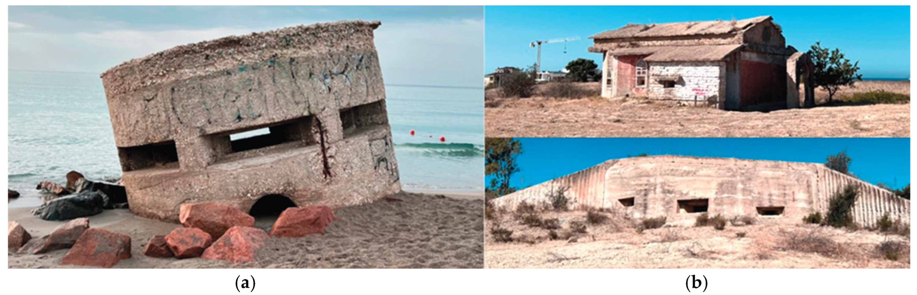
Figure 2.
Integration of forts into the landscape and their role as “sentinels” hidden underground in the areas of Bosa and Quartu Sant’Elena, Sardinia (by).
Figure 2.
Integration of forts into the landscape and their role as “sentinels” hidden underground in the areas of Bosa and Quartu Sant’Elena, Sardinia (by).
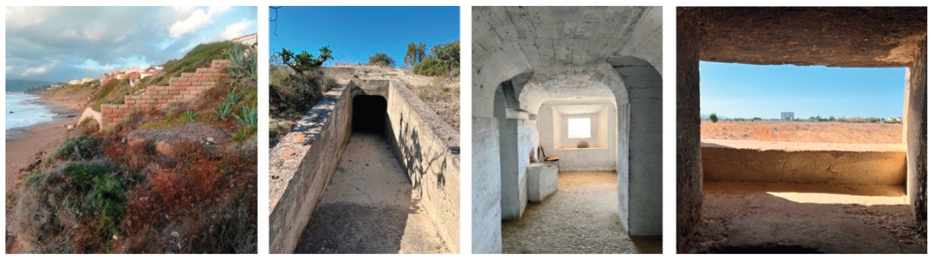
Figure 3.
Various architectural types built by the military, currently located in disparate settings in the area of Bosa, Cagliari and Quartu Sant’Elena, Sardinia (by.
Figure 3.
Various architectural types built by the military, currently located in disparate settings in the area of Bosa, Cagliari and Quartu Sant’Elena, Sardinia (by.
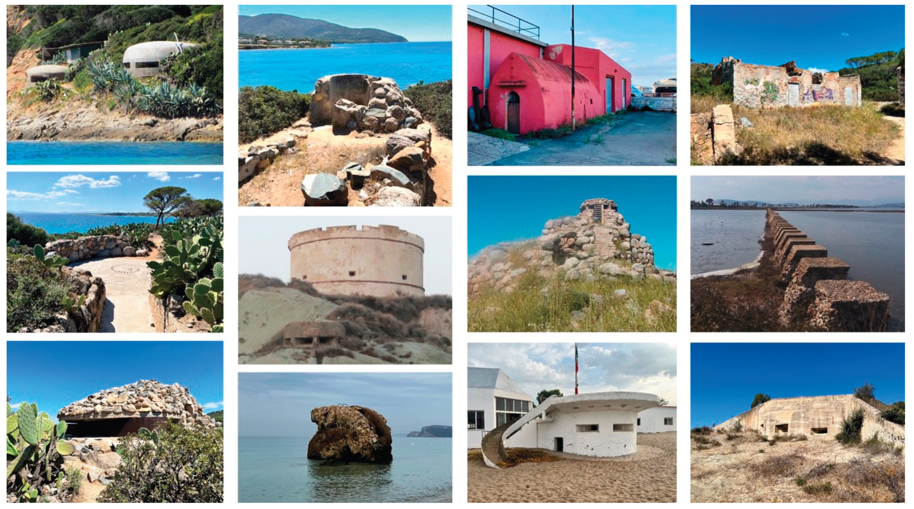
Figure 4.
(a) Defensive macro-areas of Sardinia (by) and (b) IGM map of the defense of Cagliari in 1943 [28].
Figure 4.
(a) Defensive macro-areas of Sardinia (by) and (b) IGM map of the defense of Cagliari in 1943 [28].
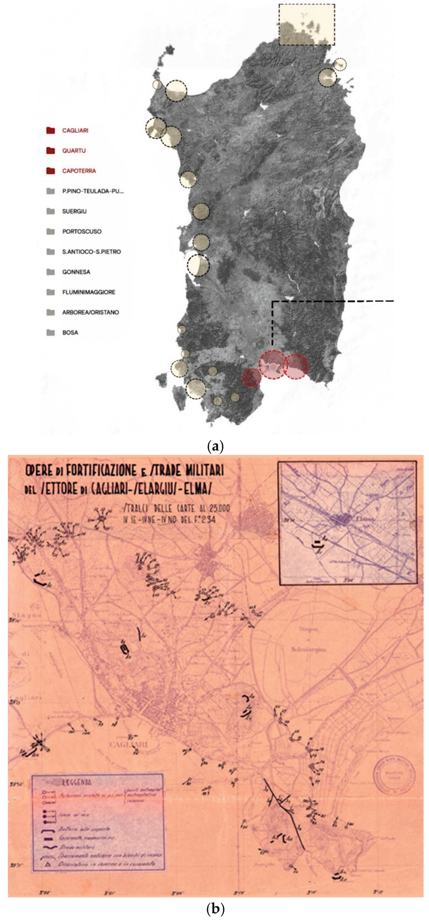
Figure 5.
Stronghold No. 14 overlooking Lake Simbirizzi in Quartu Sant’Elena, Sardinia (by).
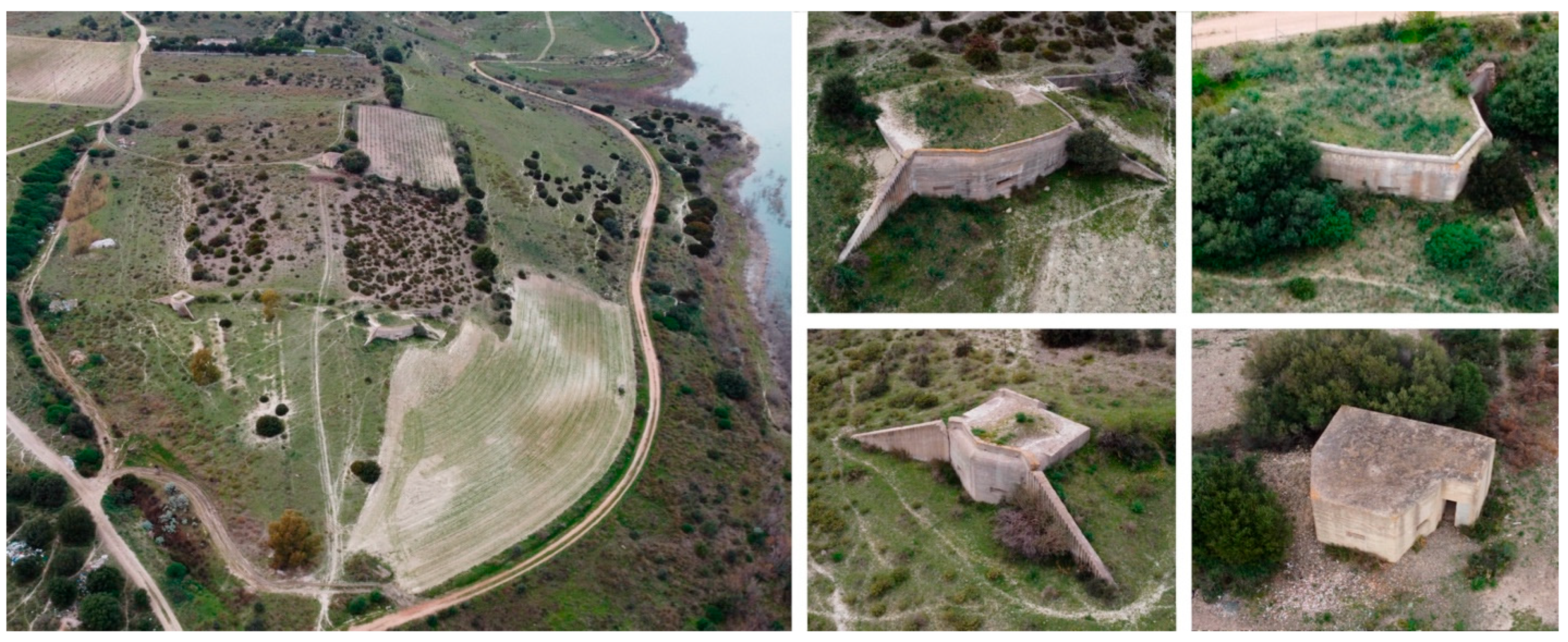
Figure 6.
Coastal Battery on the Is Mortorius promontory in Quartu Sant’Elena, Sardinia (by.
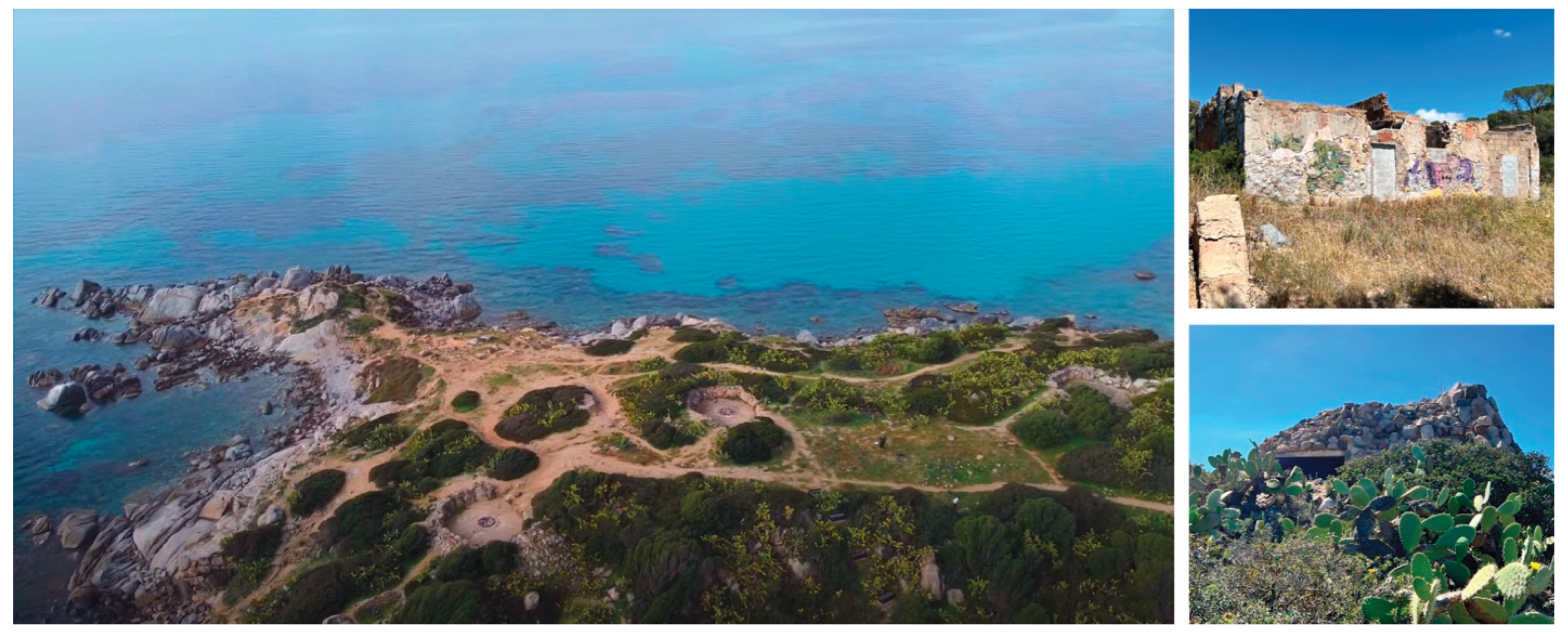
Figure 7.
Spatial organization of defensive military structures in the area of Quartu Sant’Elena, Sardinia (by ).
Figure 7.
Spatial organization of defensive military structures in the area of Quartu Sant’Elena, Sardinia (by ).
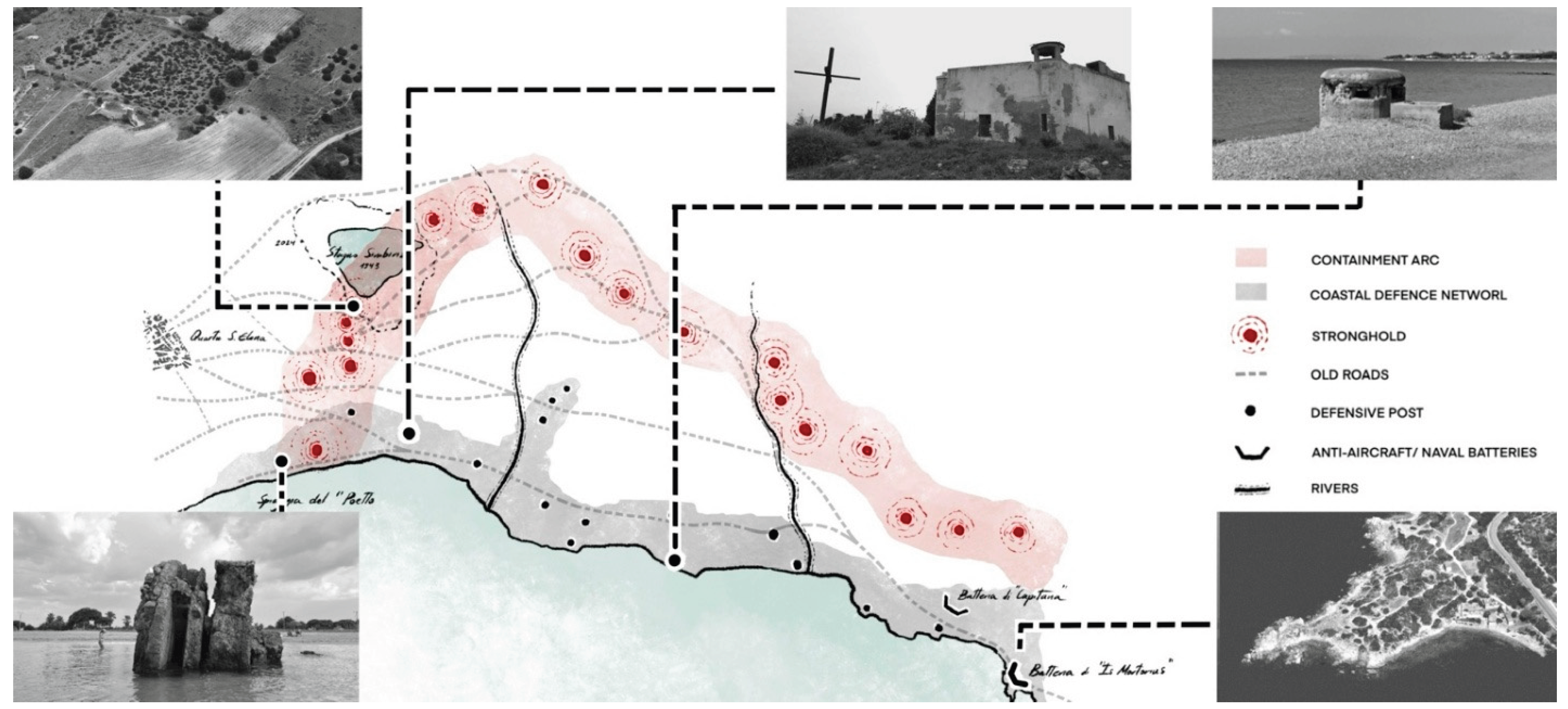
Figure 8.
Acronym used to identify the main types of defensive structures in the database (by ).
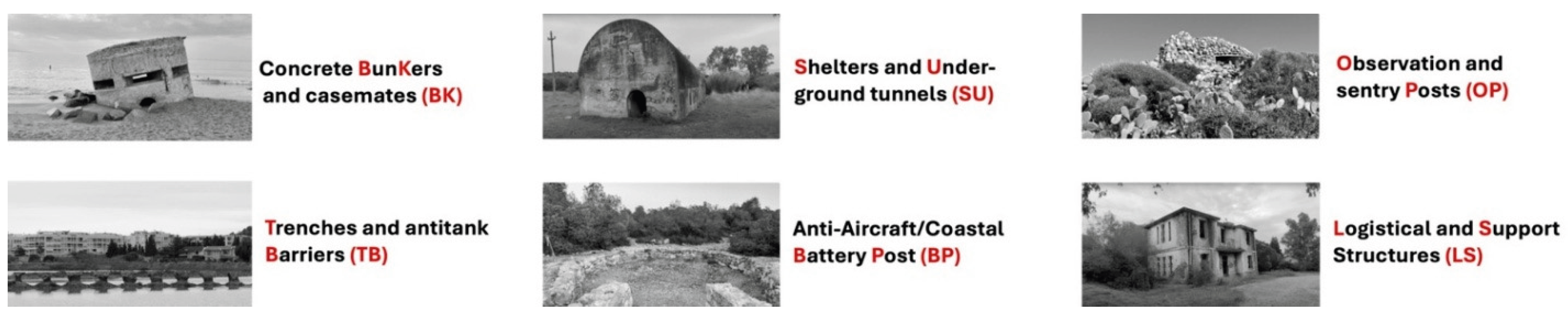
Figure 9.
Structure of the identification code (ID) of an architectural object in the database (by).
Figure 9.
Structure of the identification code (ID) of an architectural object in the database (by).
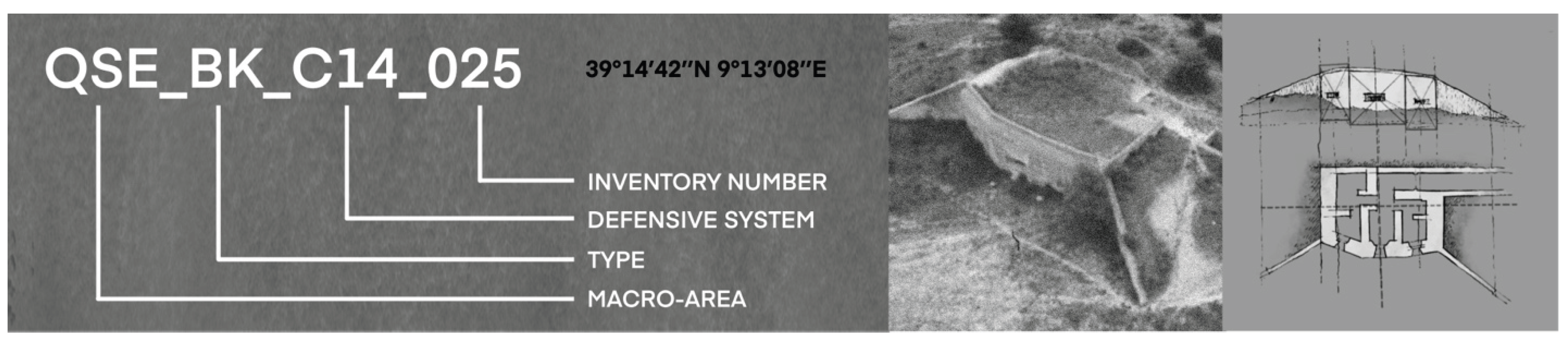
Figure 10.
Digital representations from photogrammetric survey operations (by).
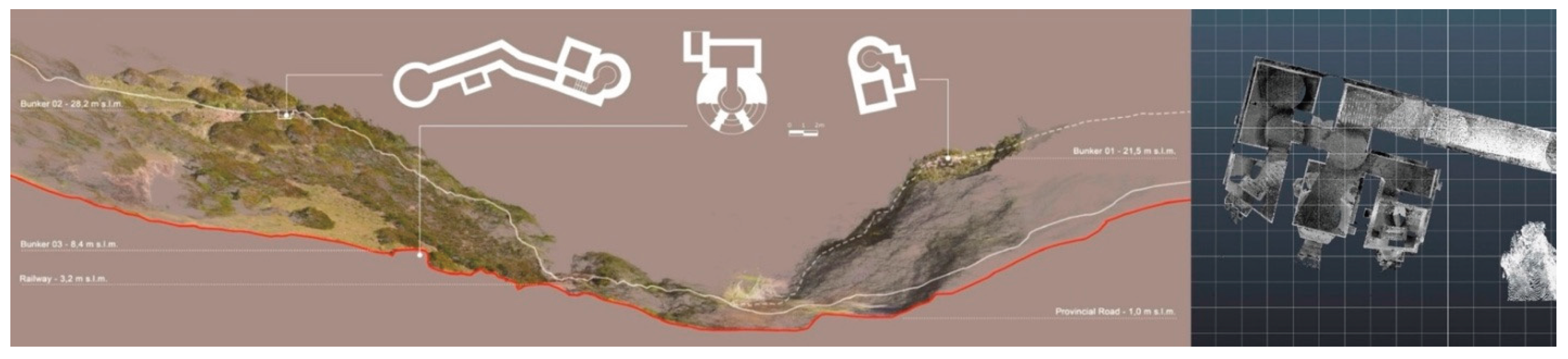
Figure 11.
(a) From archival documents [31] and (b) typological studies (c) to the development of the fortification catalogue ca. 1941 (by).
Figure 11.
(a) From archival documents [31] and (b) typological studies (c) to the development of the fortification catalogue ca. 1941 (by).
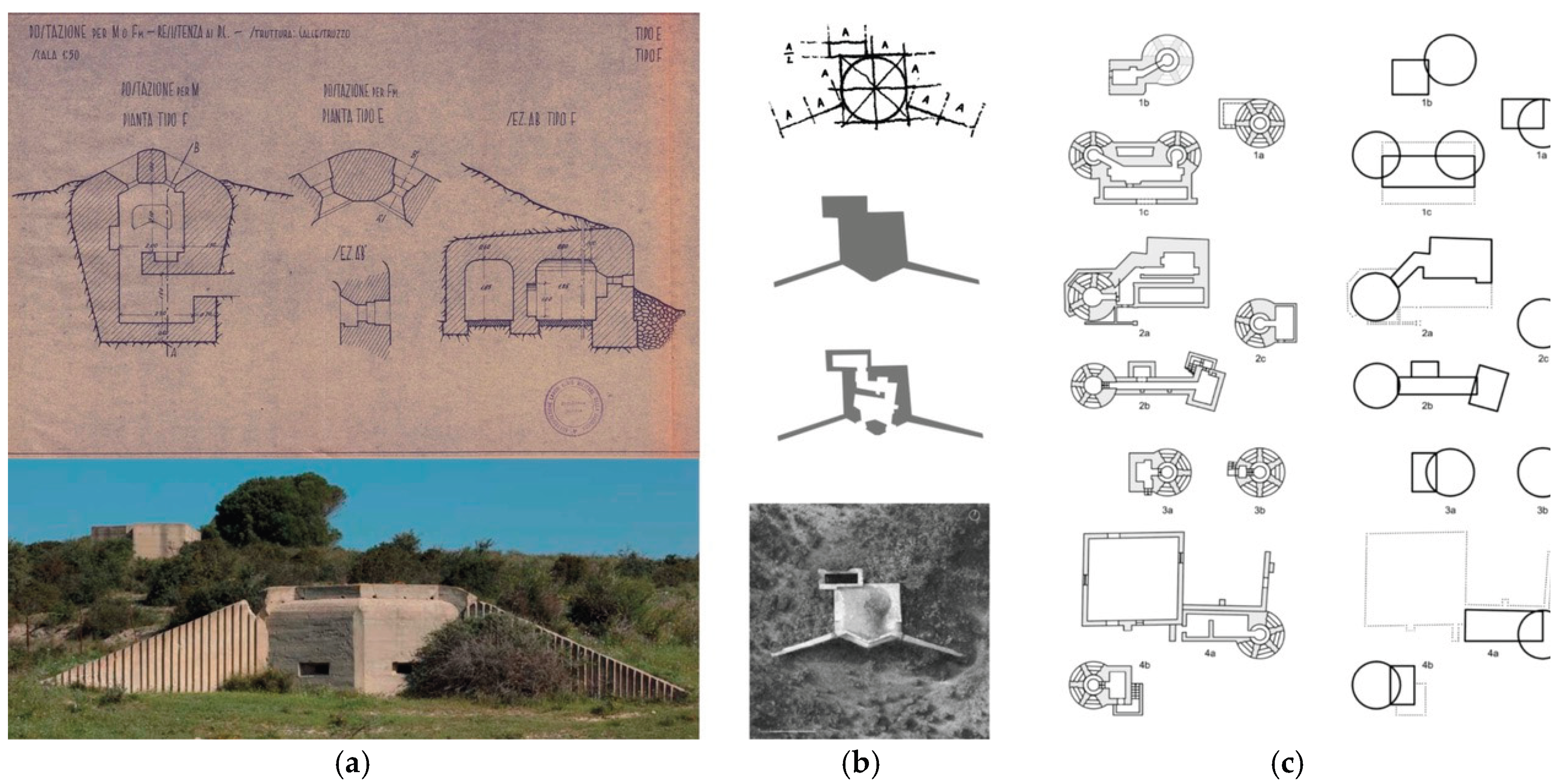
Figure 12.
(a). GIS map showing the weapon coverage from the Stronghold No. 14 overlooking Lake Simbirizzi in Quartu Sant’Elena (by ), (b) Study on the weapon coverage from the casemate bunker No. 25, part of the Stronghold No. 14 [32].
Figure 12.
(a). GIS map showing the weapon coverage from the Stronghold No. 14 overlooking Lake Simbirizzi in Quartu Sant’Elena (by ), (b) Study on the weapon coverage from the casemate bunker No. 25, part of the Stronghold No. 14 [32].
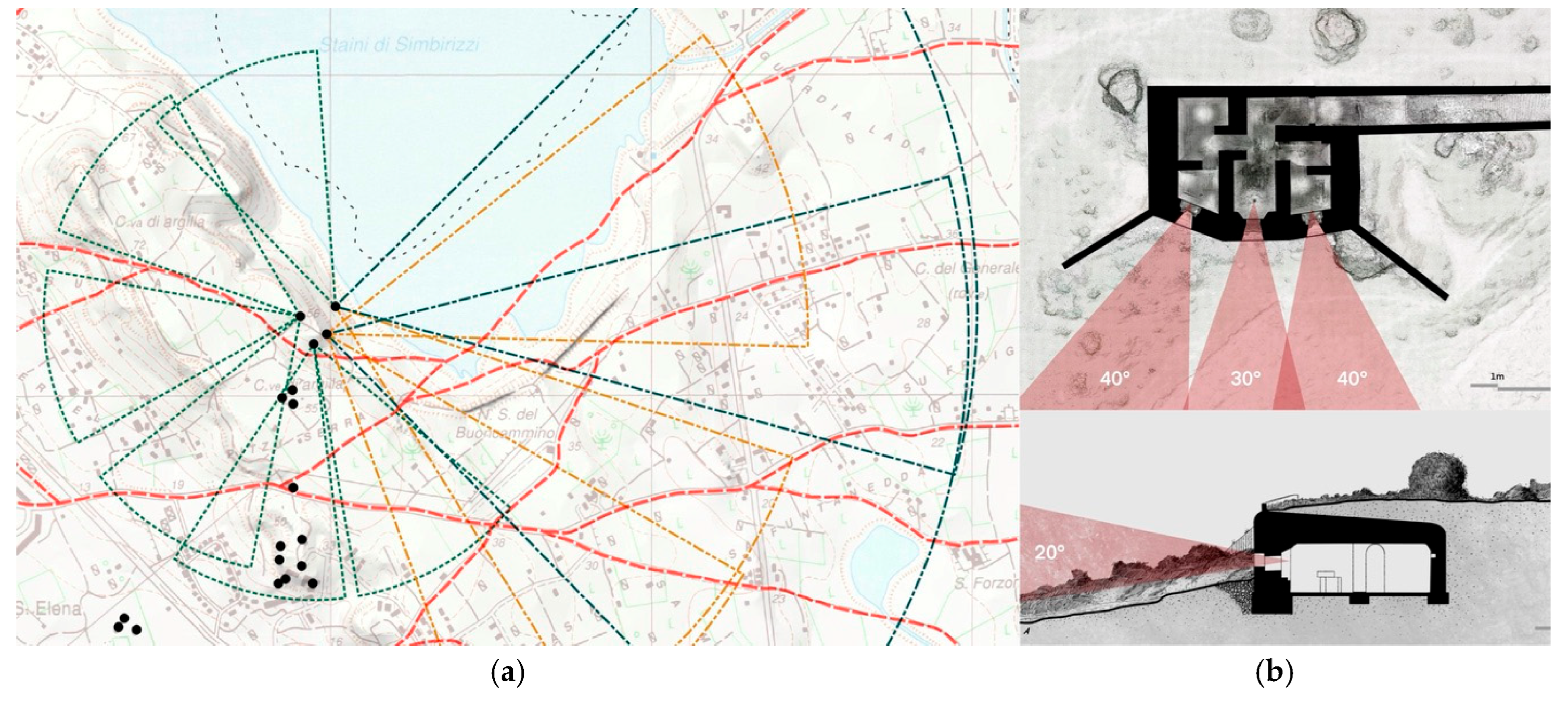
Figure 13.
Cartographic comparison: (a) IGM map, (b) satellite photo, and (c) redrawing of Stronghold No. 14 overlooking Lake Simbirizzi in Quartu Sant’Elena (by).
Figure 13.
Cartographic comparison: (a) IGM map, (b) satellite photo, and (c) redrawing of Stronghold No. 14 overlooking Lake Simbirizzi in Quartu Sant’Elena (by).
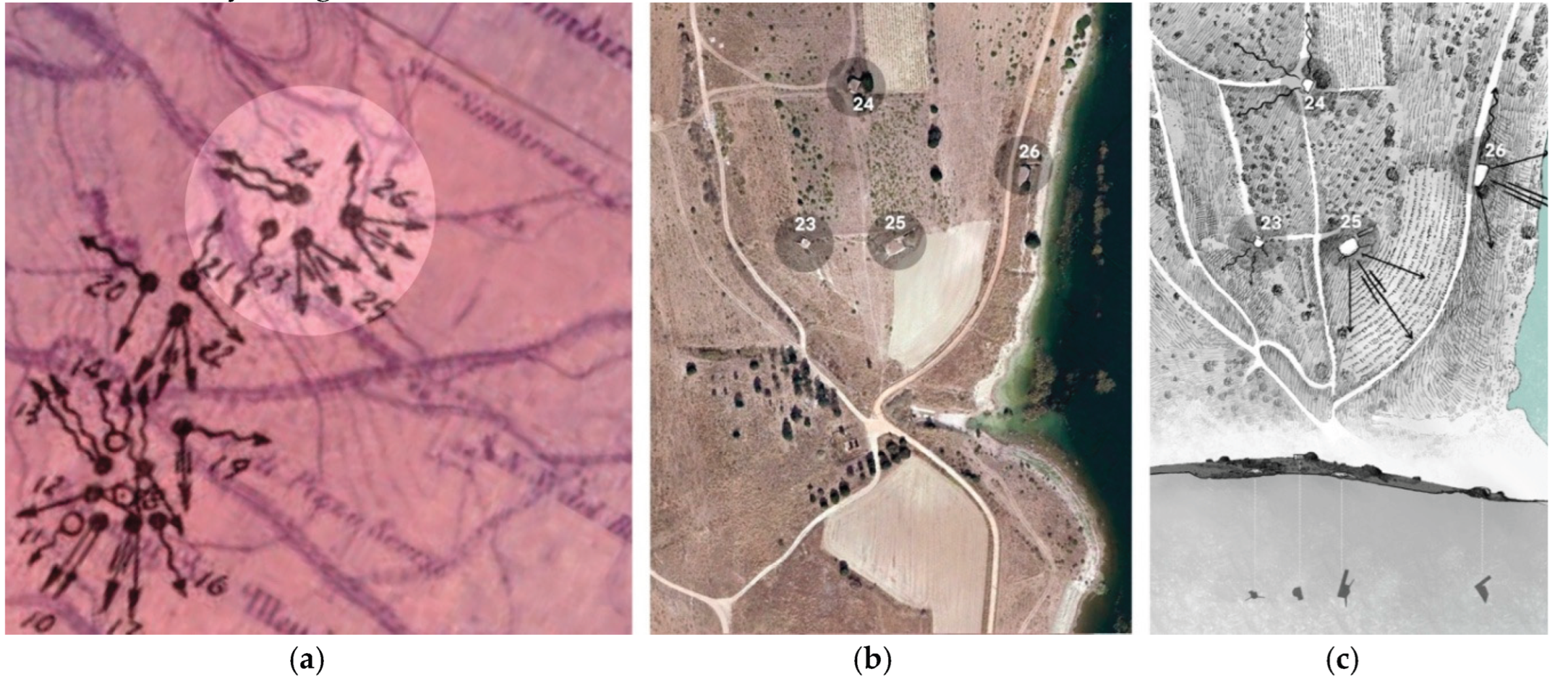
Figure 14.
Application of the hybrid representation protocol at the scale of the industrial object, bunker No. 25, part of the Stronghold No. 14 overlooking Lake Simbirizzi in Quartu Sant’Elena (by).
Figure 14.
Application of the hybrid representation protocol at the scale of the industrial object, bunker No. 25, part of the Stronghold No. 14 overlooking Lake Simbirizzi in Quartu Sant’Elena (by).
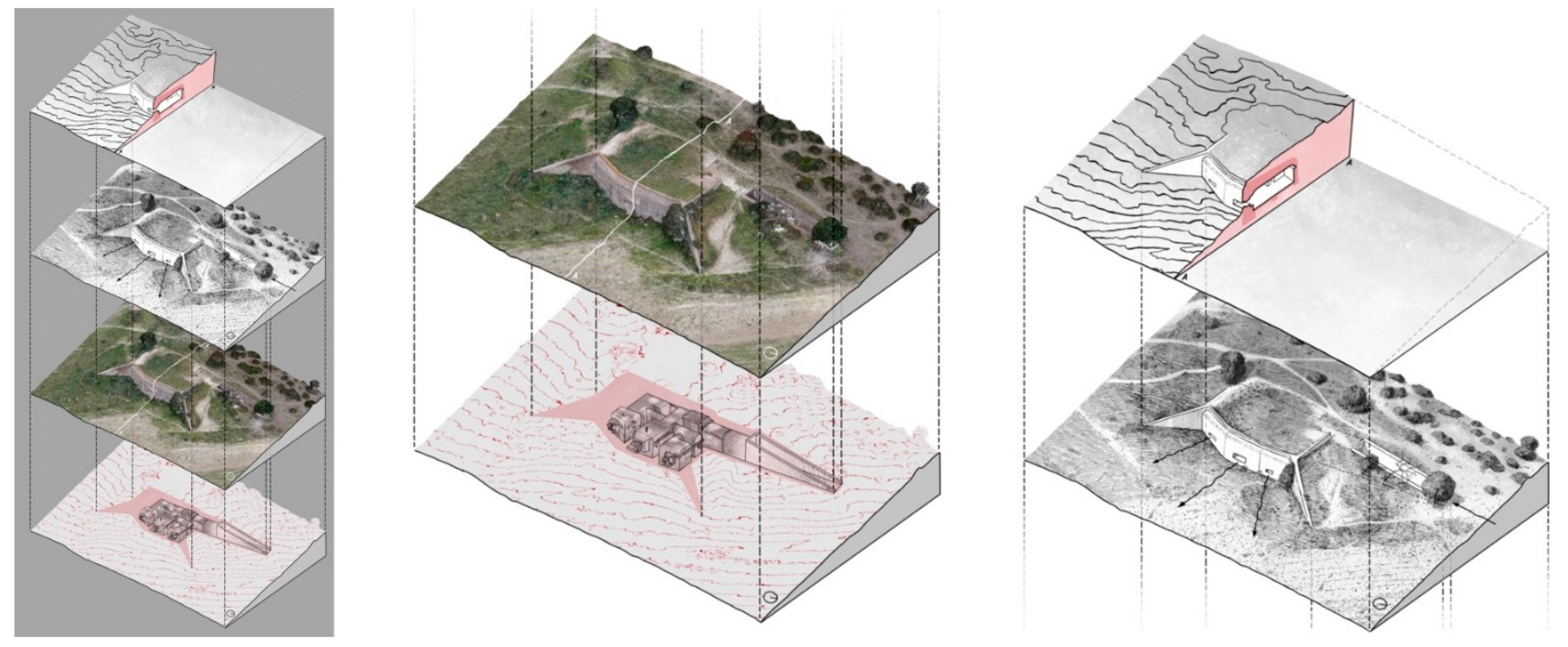
Figure 15.
Plan of landscape acupuncture interventions in 2013 at Cape Santa Pola (Alicante, Spain) on Coastal Detachment No. 4 of the Levantine Coast (ca. 1937), a project to regenerate roads, restore defences, and assess them as elements of memory of the Spanish Civil War [38].
Figure 15.
Plan of landscape acupuncture interventions in 2013 at Cape Santa Pola (Alicante, Spain) on Coastal Detachment No. 4 of the Levantine Coast (ca. 1937), a project to regenerate roads, restore defences, and assess them as elements of memory of the Spanish Civil War [38].
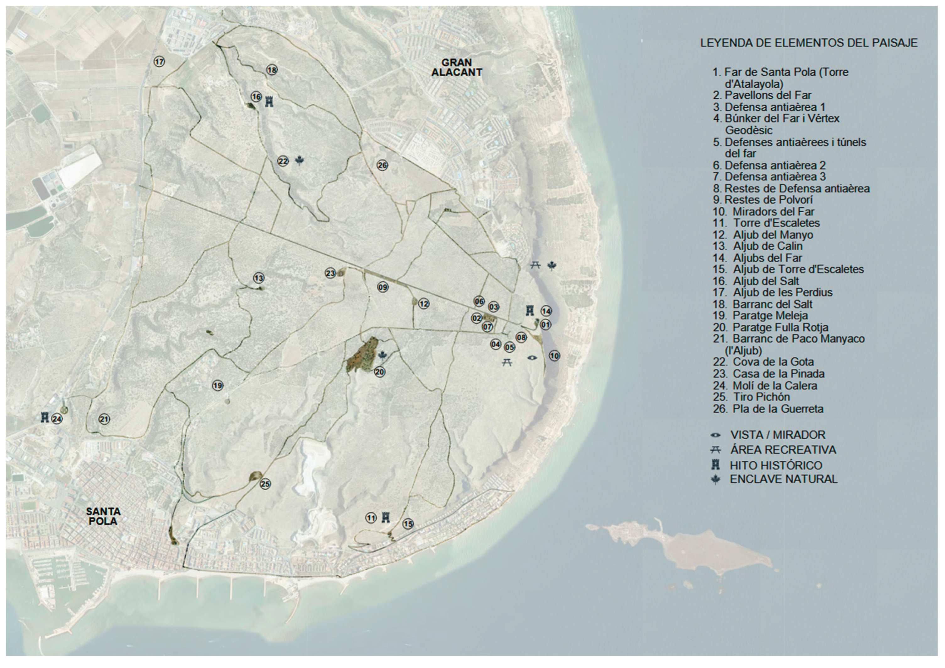
Figure 16.
Map of the cultural cycling itinerary in the territory of Arborea (Oristano, Sardinia), a valorisation project designed to reconnect and interpret over twenty Second World War bunkers through a 30 km route between the coast and the reclaimed hinterland. The itinerary proposes non-invasive reuse strategies and highlights hybridisations with pre-existing architecture, such as the Marceddì Tower complex [21].
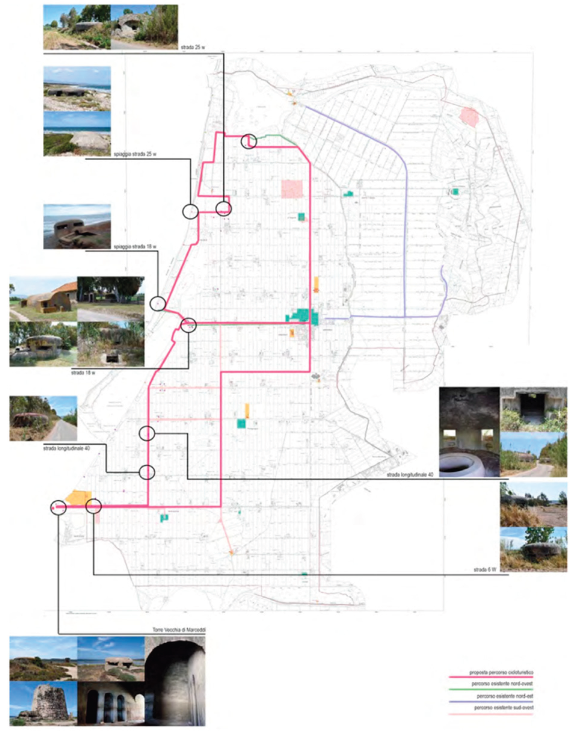
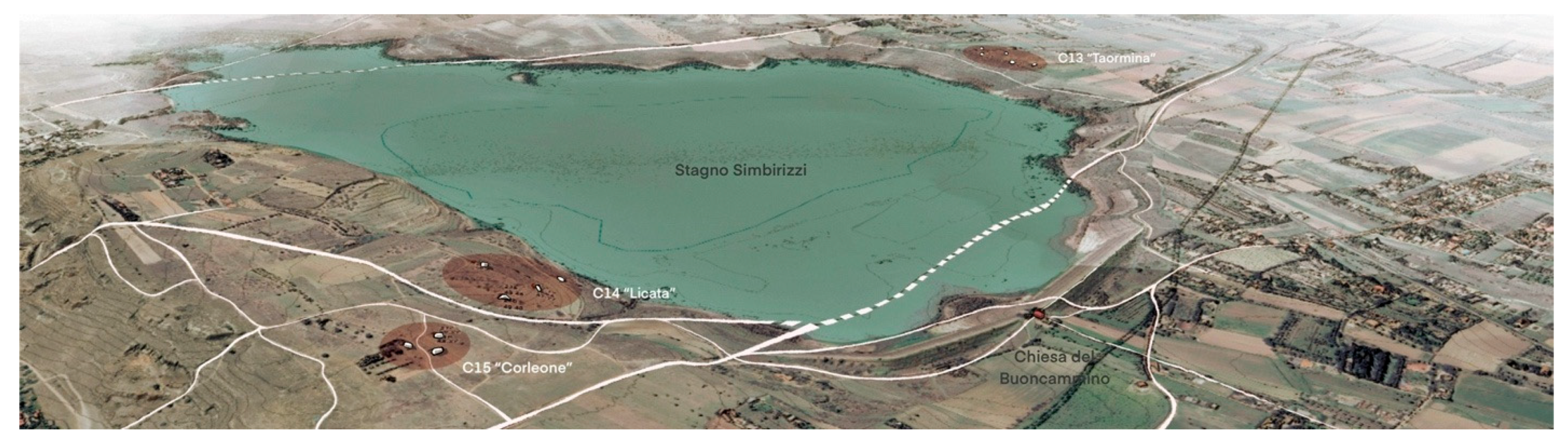
Figure 17.
Digital database under construction: 3D view of the strongholds near the Lake Simbirizzi in the area of Quartu Sant’Elena (by).
Figure 17.
Digital database under construction: 3D view of the strongholds near the Lake Simbirizzi in the area of Quartu Sant’Elena (by).
Disclaimer/Publisher’s Note: The statements, opinions and data contained in all publications are solely those of the individual author(s) and contributor(s) and not of MDPI and/or the editor(s). MDPI and/or the editor(s) disclaim responsibility for any injury to people or property resulting from any ideas, methods, instructions or products referred to in the content. |
© 2025 by the authors. Licensee MDPI, Basel, Switzerland. This article is an open access article distributed under the terms and conditions of the Creative Commons Attribution (CC BY) license (http://creativecommons.org/licenses/by/4.0/).
Copyright: This open access article is published under a Creative Commons CC BY 4.0 license, which permit the free download, distribution, and reuse, provided that the author and preprint are cited in any reuse.


