Submitted:
02 July 2025
Posted:
04 July 2025
You are already at the latest version
Abstract
Flood events driven by hydrological extremes have increased in frequency and intensity, affecting river basins globally and challenging the resilience of existing flood defense systems. In this context, hydraulic modeling has become a critical tool for simulating flow behavior, estimating inundation areas, and supporting infrastructure design under extreme scenarios. Using a PRISMA-based methodology, 92 peer-reviewed scientific articles published between 2014 and 2024 were analyzed, selected from Scopus and ProQuest databases. The review highlights the increasing global concern regarding flood vulnerability and the critical role of advanced hydraulic models such as HEC-HMS and HEC-RAS in simulating hydrodynamic behavior under various scenarios. Key findings show that the integration of geospatial data, satellite imagery, and climate models enhances prediction accuracy and decision-making. The United States, China, and India are identified as the leading contributors to this research field. The study underscores the importance of rigorous model calibration, validation, and the inclusion of socio-environmental variables to achieve comprehensive flood risk management. The findings serve as a foundation for future research and practical applications aimed at improving the resilience of vulnerable riverine communities through robust flood defense strategies.
Keywords:
hydraulic modeling
; flood defense
; river basins
; hydrological extremes
; risk simulation
1. Introduction
Flood events in riverine areas are recurrent phenomena, often resulting in significant economic, infrastructural, and social consequences [1]. In Peru, river overflows are primarily driven by intense and short-duration rainfall events, frequently exacerbated by the El Niño phenomenon, which alters precipitation patterns and increases river discharge levels [2,3,4,5]. Similar dynamics are observed globally, where rapid urban growth and limited hydraulic infrastructure amplify the vulnerability of populations residing near riverbanks [6,7,8]. The growing frequency and intensity of hydrological extremes, influenced by climate variability, underline the necessity for accurate modeling tools to support decision-making processes in flood defense planning [9]
Hydraulic modeling has become a fundamental approach in analyzing river basin dynamics, offering capabilities to simulate various hydrological scenarios and assess river system responses to extreme events [10,11]. Tools such as HEC-HMS and HEC-RAS enable the simulation of rainfall-runoff processes, flood routing, and the evaluation of flood defense performance under different climatic conditions[12]. The integration of hydrological data, geospatial information, and simulation software facilitates a detailed analysis of watershed behavior, contributing directly to the design and optimization of flood defense structures [13,14,15].
Despite the advancement of hydraulic modeling techniques, a consolidated synthesis of recent applications focusing specifically on flood defense design remains limited. Several studies have addressed the hydrological modeling of river basins [16,17,18]; however, systematic evaluations concentrating on methodologies applied to flood defense infrastructure under hydrological extremes are scarce. A systematic review can consolidate existing knowledge, identify prevailing methodologies, and highlight current research gaps necessary for improving design practices.
The objective of this systematic review is to evaluate and synthesize recent literature on hydraulic modeling applied to flood defense design in river basins, with a particular focus on methodologies addressing hydrological extremes. This review considers peer-reviewed scientific articles published between 2020 and 2024, employing a structured search strategy based on PICO criteria [19,20] and the PRISMA [21] framework for study selection.
2. Materials and Methods
2.1. Research Design
This study followed a systematic literature review methodology structured under the PRISMA 2020 framework [21,22], which defines the phases of identification, screening, eligibility, and inclusion of studies. The main objective was to synthesize the scientific literature published between 2020 and 2024 related to the application of hydraulic modeling in the design of flood defense systems in river basins, particularly under conditions of hydrological extremes.
2.2. Research Question and Criteria (Pico Framework)
To define the scope of this review, the research question was structured using the PICO framework [19,20]. The population of interest comprised river basins susceptible to fluvial, urban, or compound flood events. The intervention referred to the application of hydraulic or hydrological modeling tools, such as HEC-HMS, HEC-RAS, MIKE, or LISFLOOD. The comparison involved the evaluation of different modeling approaches or configurations applied under diverse scenarios of flood risk or mitigation strategies. The outcome focused on the contributions of these modeling efforts to the design and evaluation of flood defenses, particularly in terms of simulating inundation patterns, river discharge, and the performance of protective infrastructure. Based on this framework, the central research question guiding this systematic review was: What are the recent methodologies and applications of hydraulic modeling used in the design of flood defenses in river basins affected by hydrological extremes?
2.3. Database Selection and Search Strategy
The search was conducted in the following electronic databases: Scopus and ProQuest. The search period was limited to studies published from January 2020 to March 2024, to capture the most current methodologies and technologies post-implementation of global climate adaptation agendas. The following Boolean search string was applied (adapted as needed per database).

Table 1.
Boolean Search Strategy for Literature Review.
| Data Base | Boolean Equation |
| ProQuest and Scopus | ("hydraulic modeling" OR "hydrologic modeling" OR "flood modeling") AND ("flood defense" OR "flood protection" OR "flood control") AND ("river basin" OR "watershed") AND ("extreme events" OR "hydrological extremes" OR "climate change") AND ("simulation" OR "HEC-HMS" OR "HEC-RAS" OR "MIKE" OR "LISFLOOD") |
Scopus and ProQuest were selected because they index a wide range of peer-reviewed literature in engineering and environmental sciences, ensuring access to relevant and high-quality studies for this review.
2.4. Inclusion and Exclusion Criteria
The inclusion criteria for this systematic review, as shown in Table 2, were defined to ensure the relevance and scientific rigor of the selected studies. Only peer-reviewed journal articles and conference papers published between 2020 and 2025 were considered. Eligible studies had to involve the application of hydraulic or hydrologic models aimed at assessing or designing flood protection measures. Research was required to be conducted in either real-world or synthetic scenarios addressing fluvial, pluvial, or compound flood risks. Furthermore, articles had to present a clear description of the input data, the modeling tools employed, and the resulting outputs, with sufficient methodological detail to allow reproducibility or critical evaluation.
Conversely, studies were excluded if they did not focus explicitly on flood defense design or if they involved models applied solely to urban drainage systems without integration into broader riverine dynamics, as shown in Table 3. Publications lacking a detailed methodological explanation or validation process were also omitted. Additionally, grey literature, theses, and review articles were excluded from the analysis, except when used for background context or methodological comparison.
2.5. Article Selection Process
After the initial retrieval of documents, duplicates were removed. Titles and abstracts were screened to assess relevance. Then, full-text articles were evaluated against the inclusion criteria. A total of 42 articles were selected for in-depth analysis. The selection process is illustrated through a PRISMA flow diagram as shown in Figure 1.
2.6. Data Extraction and Synthesis
For each of the selected articles, key information was systematically extracted to enable a structured analysis. The data collected included the authors and year of publication, the geographic location of the study and the type of flood risk analyzed, and the specific hydraulic or hydrologic model applied. In addition, details on the input data—such as precipitation records, digital elevation models (DEM), and land use characteristics—were documented. Each study’s calibration and validation procedures were also recorded to assess methodological rigor. Finally, the main findings relevant to flood defense design were extracted. A comparative synthesis was then carried out to identify recurring modeling strategies, the range of hydrological extremes addressed, and the common technical challenges or methodological innovations observed across the literature.
3. Results
During the initial exploration and selection of scientific studies recorded in the Scopus and Web of Science databases on hydraulic modeling for flood defense design, a total of 92 articles were identified that met the search criteria established for this research, considering the main variable, the context, and the associated factors. Therefore, Table 4 presents the results indicating the number of selected articles found in each of the databases.
After conducting the "Systematic Review of Scientific Literature," the PRISMA Flow Diagram (Page et al., 2021) was used, applying search and selection criteria such as time range, source type, language, and keywords (hydraulic modeling, hydraulic design, flood defenses, basins, vulnerable areas, water flow, water resource management, hazard scenarios). As a result, 92 studies were identified that meet the previously mentioned criteria related to the research topic.
The methodology applied, along with the use of inclusion and exclusion criteria, allowed for the selection and analysis of 92 scientific articles based on their parameters and their relevance to the research focus, as evidenced in the PRISMA Flow Diagram presented in Figure 2.
Figure 3 shows the temporal evolution of publications on hydraulic modeling and flood defense design from 2014 to 2024. The data reflect a steady increase in research activity from 2014, reaching a peak in 2022, followed by a decline in subsequent years. This trend highlights the growing relevance of the topic over the past decade, likely in response to the intensification of hydrological extremes and the need for more robust flood risk management tools. The analysis was based on peer-reviewed articles selected through a systematic review, with additional classification by publication year, country, and journal source to contextualize the scientific production in the field.
Figure 4 presents the geographical distribution of the reviewed studies by country. The analysis revealed that the United States leads the research output in this field, contributing 46 publications focused on hydraulic or hydrological modeling for flood defense design. China follows with 36 studies, while India and Germany account for 9 and 8 publications, respectively. Other countries such as Ethiopia, the United Kingdom, Canada, Brazil, the Netherlands, and Iran contribute smaller but notable numbers of studies. This distribution highlights a strong concentration of research efforts in high-capacity countries like the United States, suggesting both a greater institutional investment in flood modeling technologies and a higher exposure to flood-related challenges. In contrast, countries with fewer contributions may reflect limited research funding, lower exposure, or reduced access to modeling tools for flood risk management.
Table 5 presents a comprehensive summary of the 22 scientific articles selected for this systematic review. It includes information such as the authors, publication titles, year of publication, journal, country or city of origin, the hydraulic modeling tools employed, and their respective reference sources. These studies cover a wide range of geographical regions and offer diverse approaches to the application of hydraulic modeling in the design of flood defense systems. The inclusion of tools such as HEC-HMS, HEC-RAS, MODFLOW, and others demonstrates the technological variety and analytical depth used in simulating hydrological behavior and planning resilient river basin protection strategies.
The analysis of 22 selected studies demonstrates that HEC-HMS is the predominant tool used in hydrological modeling for flood defense design, appearing in 18 of the reviewed articles, either as a standalone model or in combination with other systems such as HEC-RAS, which appears in 4 studies. Other tools are mentioned only once, including SWAT, Green-Ampt, GIS, MODFLOW-2005, I-RIC, FREEWAT, SAC-SMA, GR4J, proprietary modeling software, and open-source visualization tools such as Hydrovise. Geographically, the selected studies span Asia (China, Vietnam, Nepal, Indonesia, Myanmar), the Americas (USA, Canada, Mexico, Colombia, Ecuador), Europe (Spain, Italy, Germany), and Africa (Zimbabwe), covering a wide range of topics such as flood simulation, urban vulnerability assessment, climate change impacts, and flood defense planning. Notable findings include the effectiveness of HEC-HMS and HEC-RAS coupling (Rodríguez-Corzo; Sari; Amrei & Schmalz), the use of remote sensing in ungauged basins (Gumindoga; Tamiru), the development of early warning indicators (Tu), and the application of open-access platforms for data visualization (Jadidoleslam). Several studies also highlight challenges in applying specific loss models, such as Green-Ampt, especially in Mediterranean or poorly instrumented basins (Demetrio et al.). Moreover, research by Duong, Dahri, and Paudel emphasizes the growing importance of modeling future scenarios under climate variability, revealing risks such as extended wet seasons or intensified droughts, critical for hydrological planning and infrastructure design.
Methodologically, most studies follow robust calibration and validation procedures, often reporting Nash–Sutcliffe efficiency (NSE) coefficients between 0.6 and 0.9, using multiple historical flood events and parameter optimization methods, such as Nelder–Mead (Baduna et al.). Some works offer comparative evaluations between conceptual models like SAC-SMA, GR4J, and HEC-HMS (Buddika & Coulibaly), while others integrate HEC-HMS into GIS platforms to produce flood hazard maps (López; Alarcón). A noticeable increase in scholarly output is observed between 2016 and 2021, with prominent publications in Water, Environmental Modelling & Software, and Journal of Flood Risk Management. While technical accuracy remains a central concern, there is a clear trend toward incorporating open-source tools, satellite data, and high-resolution climate models. The findings collectively reinforce that, although HEC-HMS is a versatile and accessible model, its effectiveness depends significantly on the correct selection of loss models, quality of input data, and the hydrological behavior of the basin. This body of literature offers validated approaches and decision-making criteria that can improve the accuracy of flood simulations and enhance the design of hydraulic defenses in river basins exposed to hydrological extremes (Jadidoleslam et al.; Khaled et al.; Baek et al.; Hussain et al.; Buddika & Coulibaly; Halwatura & Najim; Gumindoga et al.; Tamiru et al.; Cabrera et al.; López et al.; Sari; Duong et al.; Tu et al.; Amrei & Schmalz; Baduna et al.; Alarcón et al.; Wulan; Ramos & Pacheco; Rodríguez-Corzo; Paudel & Basnet; Demetrio et al.; Thu).
4. Discussion
In response to the research question addressed through the systematic literature review, an extensive analysis of selected studies from 2014 to 2024 was carried out. The increasing number of publications over this period highlights the growing interest of the scientific and professional community in understanding the role of hydraulic modeling in the design of flood defenses. This modeling contributes to defining the composition, origin, and discharge of flows, as well as identifying potential contaminants, thereby reinforcing the responsibility to ensure water quality and sustainability.
The findings underscore the critical importance of advanced hydraulic models—particularly HEC-HMS and HEC-RAS—for simulating and understanding hydrodynamic behavior in river systems under different climate conditions and hydrological scenarios. Studies such as Duong et al. [34] and Hussain et al. [26] emphasize how these tools enable accurate assessments of river dynamics and responsiveness to extreme events, thus facilitating effective flood defense planning.
Furthermore, the review highlights the key role of geospatial data integration and remote sensing in enhancing model calibration and validation, as discussed by [29]. These integrated approaches not only increase the precision of flood predictions but also enhance the efficiency of water resource management and community resilience in vulnerable flood-prone areas.
Wang et al [43] for example, stresses the necessity of considering climate change effects in the intensification of flood risks, particularly in low-lying and coastal zones. This affirms the ongoing need to refine hydraulic models to improve future scenario forecasting and enhance predictive capacity in the face of emerging threats.
Overall, the reviewed studies confirm that hydraulic modeling provides powerful tools to evaluate the capacity of river systems to handle varying flow rates and extreme events. Ramos and Pacheco [40] demonstrated that models like HEC-HMS and HEC-RAS are capable of accurately simulating runoff patterns and flood dynamics under diverse hydrological conditions. These models are not only useful for forecasting water behavior but are also essential for the technical design of structures that can withstand and mitigate flood impacts.
Moreover, the review underscores that rigorous calibration and validation processes are fundamental to ensuring model reliability. Research by Souza [1,15] reinforces the importance of using high-quality data and robust methodologies to adjust model parameters, thereby ensuring realistic and field-representative predictions.
Salomón [42] further highlights the need to consider not only the hydraulic capacities of rivers and basins but also the socio-economic and environmental consequences of floods. This indicates that technical design alone is insufficient; integrated planning must also address broader risk management perspectives.
The incorporation of geospatial tools and modeling into Geographic Information Systems (GIS) has also emerged as standard practice. For instance, previous studies [30,44] used satellite imagery and digital elevation models to improve spatial resolution and modeling accuracy, facilitating more effective water management in flood-prone regions.
5. Conclusions
This systematic review presents the main developments in hydraulic modeling, with tools such as HEC-HMS and HEC-RAS widely used for simulating flood dynamics and designing flood protection systems. These tools are frequently applied in hydrodynamic analysis and continue to be updated for improved technical performance.
The review documents the integration of geospatial technologies—such as GIS platforms, satellite imagery, and digital elevation models—which has contributed to higher spatial resolution and improved predictive capacity in hydraulic simulations. These advancements support the development of flood risk maps and facilitate planning in areas exposed to hydrological threats.
The incorporation of climate change scenarios in hydraulic modeling is a recurring element in the reviewed studies. This inclusion allows the models to reflect projected variations in the frequency and intensity of hydrological events under different future conditions.
The review identifies the limited presence of case studies in certain geographic regions and a lack of consistent and high-quality hydrological data. It also notes the importance of incorporating real-time data and applying interdisciplinary approaches to support water resource planning and risk analysis.
The compiled evidence may be used by engineers, planners, and authorities responsible for the design and management of flood defenses and river basins. It also highlights the importance of including socio-economic and environmental variables in flood risk assessment processes.
Author Contributions
Conceptualization, Y.H. and V.A.F.; methodology, V.A.F. and F.S.; software, F.D.C.; validation, Y.H., F.S. and V.A.F.; formal analysis, V.A.F.; investigation, J.E.E. and V.A.F.; resources, Y.H.; data curation, J.E.E. and C.B.G.; writing—original draft preparation, V.A.F.; writing—review and editing, F.S. and C.B.G.; visualization, C.B.G.; supervision, Y.H. and V.A.F.; project administration, Y.H.; funding acquisition, Y.H. and C.B.G. All authors have read and agreed to the published version of the manuscript.
Funding
This research received no external funding.
Data Availability Statement
We encourage all authors of articles published in MDPI journals to share their research data. In this section, please provide details regarding where data supporting reported results can be found, including links to publicly archived datasets analyzed or generated during the study. Where no new data were created, or where data is unavailable due to privacy or ethical restrictions, a statement is still required. Suggested Data Availability Statements are available in section “MDPI Research Data Policies” at https://www.mdpi.com/ethics.
Acknowledgments
During the preparation of this manuscript, the authors used ChatGPT-4 (OpenAI, 2025) for the purposes of improving the clarity, fluency, and technical precision of the English-language writing. The authors have reviewed and edited the output and take full responsibility for the content of this publication. The authors acknowledge the technical and logistical support provided by Ariza Ingenieros Consulting Firm, whose collaboration contributed to the development and analysis of this study.
Conflicts of Interest
The authors declare no conflicts of interest.
References
- V. Ariza Flores, F. O. de Sousa, and S. Oda, “Enhancing Risk Management in Road Infrastructure Facing Flash Floods through Epistemological Approaches,” Buildings, vol. 14, no. 7, p. 1931, Jun. 2024. [CrossRef]
- A. Foucher, S. Morera, M. Sanchez, J. Orrillo, and O. Evrard, “El Niño–Southern Oscillation (ENSO)-driven hypersedimentation in the Poechos Reservoir, northern Peru,” Hydrol Earth Syst Sci, vol. 27, no. 17, pp. 3191–3204, Sep. 2023. [CrossRef]
- M. Farias de Reyes, E. Chávarri-Velarde, V. Cotrina, P. Aguilar, and L. Vegas, “Space-Time Variability of Maximum Daily Rainfall in Piura River Basin in Peru Related to El Niño Occurrence,” Water (Basel), vol. 16, no. 23, p. 3452, Nov. 2024. [CrossRef]
- C. Rodríguez-Morata, H. F. Díaz, J. A. Ballesteros-Canovas, M. Rohrer, and M. Stoffel, “The anomalous 2017 coastal El Niño event in Peru,” Clim Dyn, vol. 52, no. 9–10, 2019. [CrossRef]
- NOAA. “February 2019 ENSO Update: El Niño conditions are here,” Maryland, Feb. 2019. Available online: https://www.climate.gov/news-features/blogs/enso/february-2019-enso-update-el-ni%C3%B1o-conditions-are-here (accessed on 9 January 2023).
- B. Datta and, G. Kourakos, “Preface: Optimization for groundwater characterization and management,” Hydrogeol J, vol. 23, no. 6, pp. 1043–1049, Sep. 2015. [CrossRef]
- Y. Jiang, M. Cao, D. Yuan, Y. Zhang, and Q. He, “Hydrogeological characterization and environmental effects of the deteriorating urban karst groundwater in a karst trough valley: Nanshan, SW China,” Hydrogeol J, vol. 26, no. 5, pp. 1487–1497, Aug. 2018. [CrossRef]
- V. A. Ariza Flores and R. Salvador, “Adaptive Risk Management in Road Construction: Oyon-Ambo Highway Insights, El Niño 2019 Case Study,” E3S Web of Conferences, vol. 497, p. 02020, Mar. 2024. [CrossRef]
- C. Cherubini, S. Sathish, and N. Pastore, “Dynamics of Coastal Aquifers: Conceptualization and Steady-State Calibration of Multilayer Aquifer System—Southern Coast of Emilia Romagna,” Water (Basel), vol. 15, no. 13, p. 2384, Jun. 2023. [CrossRef]
- R. Talchabhadel, H. McMillan, S. S. Palmate, R. Sanchez, Z. Sheng, and S. Kumar, “Current Status and Future Directions in Modeling a Transboundary Aquifer: A Case Study of Hueco Bolson,” Water (Basel), vol. 13, no. 22, p. 3178, Nov. 2021. [CrossRef]
- K. Harizi, M. R. Menani, N. Chabour, and S. Labar, “Initial assessment of the groundwater flow and budget using Geographic Information System, MODFLOW-2005 and the FREEWAT modeling tool in Bouteldja coastal aquifer (Northern East of Algeria),” Acque Sotterranee - Italian Journal of Groundwater, vol. 10, no. 3, pp. 41–51, Sep. 2021. [CrossRef]
- J. M. Murillo and L. Vega, “Groundwater and Protected Natural Areas in Spain. The hydrogeological characterization of National Parks,” Boletín Geológico y Minero, vol. 130, no. 4, pp. 549–592, Dec. 2019. [CrossRef]
- P. Carrión-Mero, N. Montalván-Burbano, G. Herrera-Franco, L. Domínguez-Granda, Lady Bravo-Montero, and F. Morante-Carballo, “Research Trends in Groundwater and Stable Isotopes,” Water (Basel), vol. 14, no. 19, p. 3173, Oct. 2022. [CrossRef]
- R. Barthel and S. Banzhaf, “Groundwater and Surface Water Interaction at the Regional-scale – A Review with Focus on Regional Integrated Models,” Water Resources Management, vol. 30, no. 1, pp. 1–32, Jan. 2016. [CrossRef]
- F. Oliveira de Sousa, V. A. Ariza Flores, C. S. Cunha, S. Oda, and H. Xavier Ratton Neto, “Multi-Criteria Assessment of Flood Risk on Railroads Using a Machine Learning Approach: A Case Study of Railroads in Minas Gerais,” Infrastructures (Basel), vol. 10, no. 1, p. 12, Jan. 2025. [CrossRef]
- X. Duan, Z. Sun, S. Li, Z. Jiang, and H. Liao, “Hydrogeochemical Characteristics and Environment Quality Assessment of Karst Groundwater in Mengzi Basin of Yunnan Province, China,” Water (Basel), vol. 15, no. 11, p. 2126, Jun. 2023. [CrossRef]
- Z. Moussaoui et al., “Hydrogeochemical and Stable Isotope Data of the Groundwater of a Multi-Aquifer System in the Maknessy Basin (Mediterranean Area, Central Tunisia),” Hydrology, vol. 10, no. 2, p. 32, Jan. 2023. [CrossRef]
- S. Banerjee and P. K. Sikdar, “Hydrogeological characterization of the Quaternary aquifer of south Bengal Basin in India and the impact of urbanization on the groundwater resources of the system,” Hydrogeol J, vol. 29, no. 4, pp. 1463–1484, Jun. 2021. [CrossRef]
- W. Richardson, M. Wilson, J. Nishikawa, and R. Hayward, “The well-built clinical question: a key to evidence-based decisions,” ACP J Club, 1005. [CrossRef]
- C. Schardt, M. B. Adams, T. Owens, S. Keitz, and P. Fontelo, “Utilization of the PICO framework to improve searching PubMed for clinical questions,” BMC Med Inform Decis Mak, vol. 7, no. 1, p. 16, Dec. 2007. [CrossRef]
- D. Moher, A. Liberati, J. Tetzlaff, and D. G. Altman, “Preferred reporting items for systematic reviews and meta-analyses: the PRISMA statement,” BMJ, vol. 339, no. jul21 1, pp. b2535–b2535, Jul. 2009. [CrossRef]
- M. J. Page et al., “The PRISMA 2020 statement: an updated guideline for reporting systematic reviews,” BMJ, p. n71, Mar. 2021. [CrossRef]
- N. Jadidoleslam, R. Goska, R. Mantilla, and W. F. Krajewski, “Hydrovise: A non-proprietary open-source software for hydrologic model and data visualization and evaluation,” Environmental Modelling & Software, vol. 134, p. 104853, Dec. 2020. [CrossRef]
- K. Harizi, M. R. Menani, N. Chabour, and S. Labar, “Initial assessment of the groundwater flow and budget using Geographic Information System, MODFLOW-2005 and the FREEWAT modeling tool in Bouteldja coastal aquifer (Northern East of Algeria),” Acque Sotterranee - Italian Journal of Groundwater, vol. 10, no. 3, pp. 41–51, Sep. 2021. [CrossRef]
- S.-S. Baek et al., “Developing a hydrological simulation tool to design bioretention in a watershed,” Environmental Modelling & Software, vol. 122, p. 104074, Dec. 2019. [CrossRef]
- Z. H. Dahri et al., “Climate change and hydrological regime of the high-altitude Indus basin under extreme climate scenarios,” Science of The Total Environment, vol. 768, p. 144467, May 2021. [CrossRef]
- D. B. Wijayarathne and P. Coulibaly, “Identification of hydrological models for operational flood forecasting in St. John’s, Newfoundland, Canada,” J Hydrol Reg Stud, vol. 27, p. 100646, Feb. 2020. [CrossRef]
- D. Halwatura and M. M. M. Najim, “Application of the HEC-HMS model for runoff simulation in a tropical catchment,” Environmental Modelling & Software, vol. 46, pp. 155–162, Aug. 2013. [CrossRef]
- W. Gumindoga, D. T. Rwasoka, I. Nhapi, and T. Dube, “Ungauged runoff simulation in Upper Manyame Catchment, Zimbabwe: Application of the HEC-HMS model,” Physics and Chemistry of the Earth, Parts A/B/C, vol. 100, pp. 371–382, Aug. 2017. [CrossRef]
- A. T. Haile, F. T. Tefera, and T. Rientjes, “Flood forecasting in Niger-Benue basin using satellite and quantitative precipitation forecast data,” International Journal of Applied Earth Observation and Geoinformation, vol. 52, pp. 475–484, Oct. 2016. [CrossRef]
- L. M. Timbe Castro, P. J. Crespo Sánchez, and J. J. Cabrera-Balarezo, “Evaluation of the HEC-HMS model for the hydrological simulation of a paramo basin,” Dyna (Medellin), vol. 86, no. 210, pp. 338–344, Jul. 2019. [CrossRef]
- J. J. López, M. González, A. Scaini, M. Goñi, J. V. Valdenebro, and F. N. Gimena, “Caracterización del modelo HEC-HMS en la cuenca de río Arga en Pamplona y su aplicación a cinco avenidas significativas,” Obras y proyectos, no. 12, pp. 15–30, 2012. [CrossRef]
- P. Sari, D. Legono, and J. Sujono, “Performance of Retarding Basin in Flood Disaster Risk Mitigation in Welang River, East Java Province, Indonesia,” Journal of the Civil Engineering Forum, vol. 4, no. 2, p. 109, May 2018. [CrossRef]
- P. C. Duong, A. Nauditt, D. H. Nam, and N. T. Phong, “Assessment of climate change impact on river flow regimes in The Red River Delta, Vietnam – A case study of the Nhue-Day River Basin,” Journal of Natural Resources and Development, vol. 6, pp. 81–91, 2016. [CrossRef]
- H. Tu, X. Wang, W. Zhang, H. Peng, Q. Ke, and X. Chen, “Flash Flood Early Warning Coupled with Hydrological Simulation and the Rising Rate of the Flood Stage in a Mountainous Small Watershed in Sichuan Province, China,” Water (Basel), vol. 12, no. 1, p. 255, Jan. 2020. [CrossRef]
- A. David and, B. Schmalz, “Flood hazard analysis in small catchments: Comparison of hydrological and hydrodynamic approaches by the use of direct rainfall,” J Flood Risk Manag, vol. 13, no. 4, Dec. 2020. [CrossRef]
- H. M. Baduna Koçyiğit, H. Akay, and A. M. Yanmaz, “Estimation of Hydrologic Parameters of Kocanaz Watershed by a Hydrologic Model,” International Journal Of Engineering & Applied Sciences, vol. 9, no. 4, pp. 42–50, Dec. 2017. [CrossRef]
- A. Alarcón-Neva, J. Chávez-Morales, Ó. L. Palacios-Vélez, and L. A. Ibáñez-Castillo, “Estimación de áreas vulnerables a inundaciones en zonas urbanas: Morelia, Michoacán, México,” Tecnología y ciencias del agua, vol. 11, no. 3, pp. 01–26, May 2020. [CrossRef]
- I. C. Wulan Dhari, “The Use of Rainfall Variability in Flood Countermeasure Planning,” Journal of the Civil Engineering Forum, vol. 3, no. 3, p. 157, Sep. 2017. [CrossRef]
- A. Ramos Moreno and J., A. Pacheco Fontalvo, “Análisis hidrológico e hidráulico de la cuenca del Río Frío, municipios de Ciénaga y zona bananera, departamento del Magdalena.,” Revista Logos, Ciencia & Tecnología, vol. 9, no. 1, Jul. 2017. [CrossRef]
- R. Paudel and K. Basnte, “Application of HEC-HMS model for runoff simulation: A case study of Marshyangdi River Basin in Nepal,” in Proceedings of Graduate Conference,2019-Winter, Nepal, 2019. [CrossRef]
- D. A. Zema, A. Labate, D. Martino, and S. M. Zimbone, “Comparing Different Infiltration Methods of the HEC-HMS Model: The Case Study of the Mésima Torrent (Southern Italy),” Land Degrad Dev, vol. 28, no. 1, pp. 294–308, Jan. 2017. [CrossRef]
- J. Wang, M. Jin, G. Lu, D. Zhang, F. Kang, and B. Jia, “Investigation of discharge-area groundwaters for recharge source characterization on different scales: the case of Jinan in northern China,” Hydrogeol J, vol. 24, no. 7, pp. 1723–1737, Nov. 2016. [CrossRef]
- G. Antzoulatos et al., “Flood Hazard and Risk Mapping by Applying an Explainable Machine Learning Framework Using Satellite Imagery and GIS Data,” Sustainability, vol. 14, no. 6, p. 3251, Mar. 2022. [CrossRef]
Figure 1.
PRISMA 2020 Flow Diagram.
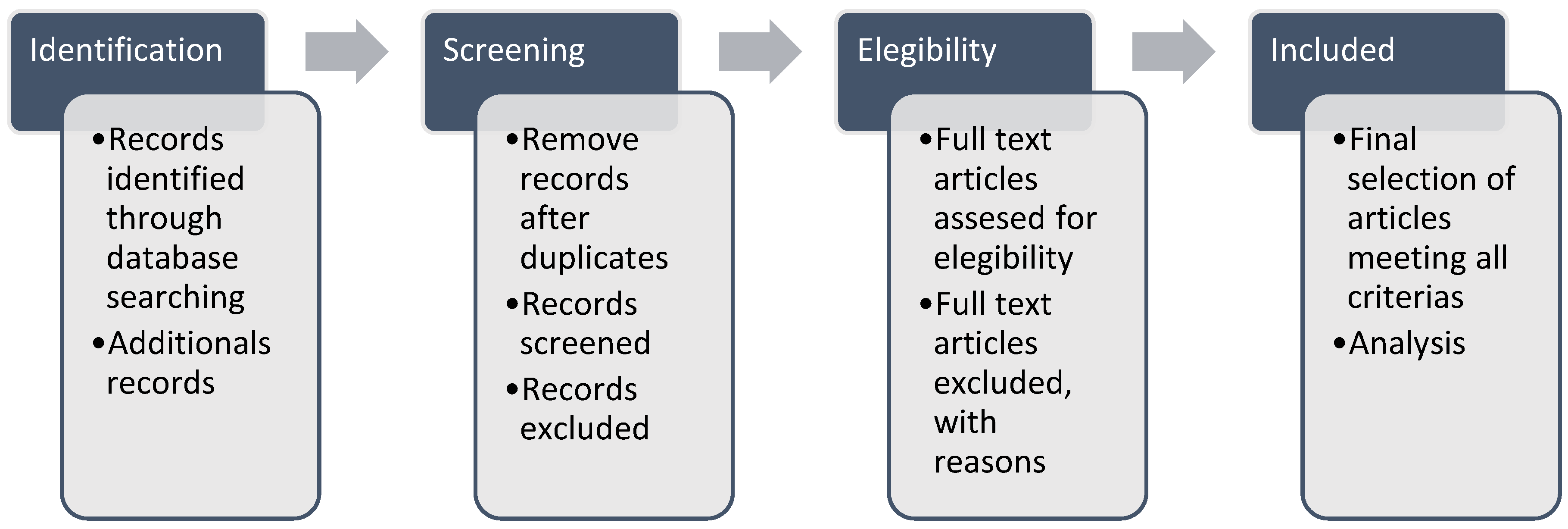
Figure 2.
Identification of studies through databases and records.
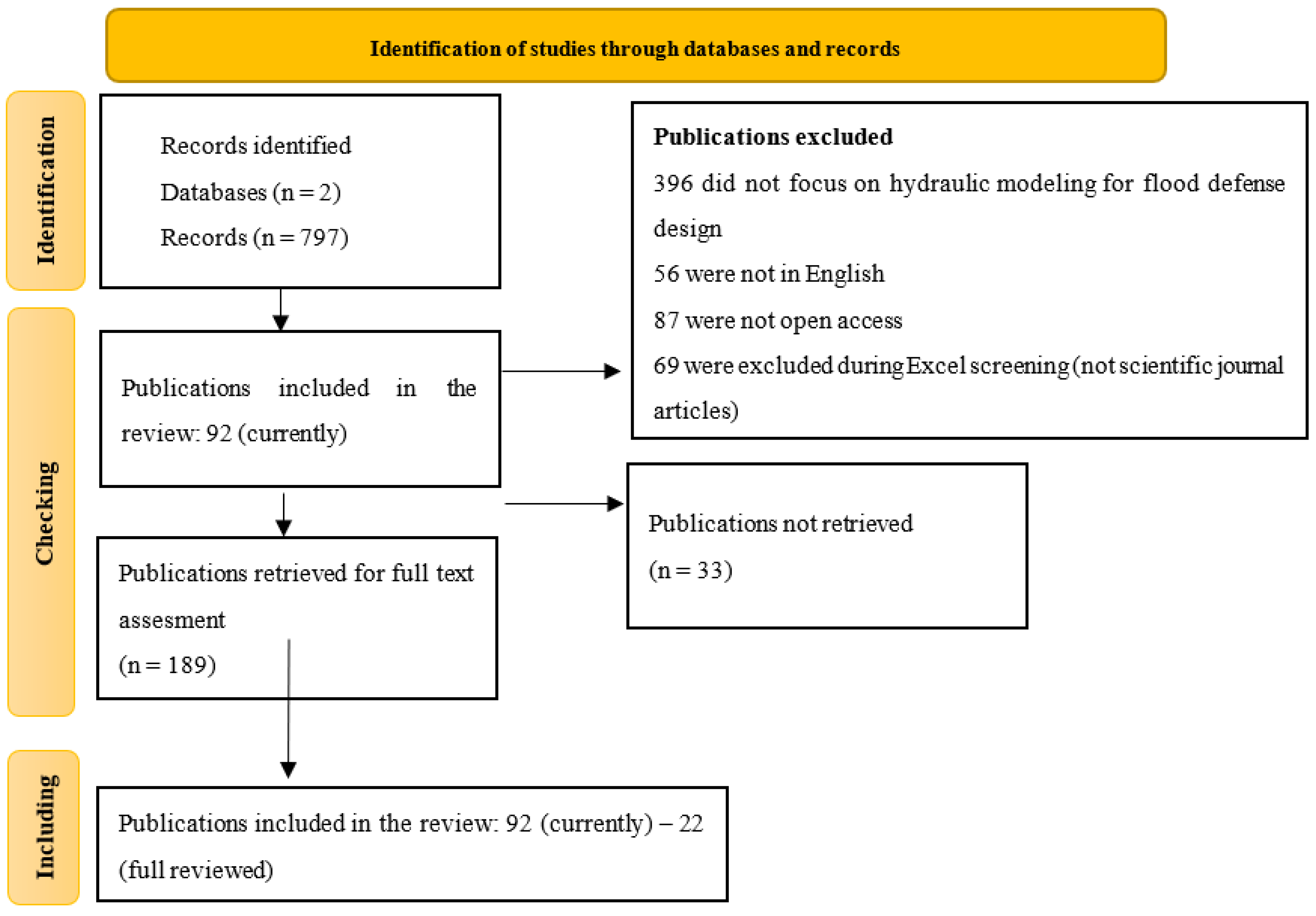
Figure 3.
Temporal evolution of publications on hydraulic modeling and flood defense design from 2014 to 2024.
Figure 3.
Temporal evolution of publications on hydraulic modeling and flood defense design from 2014 to 2024.
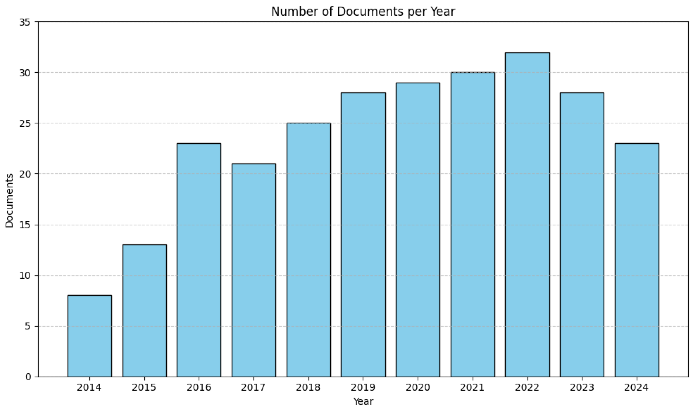
Figure 4.
Geographical distribution of reviewed studies by country.
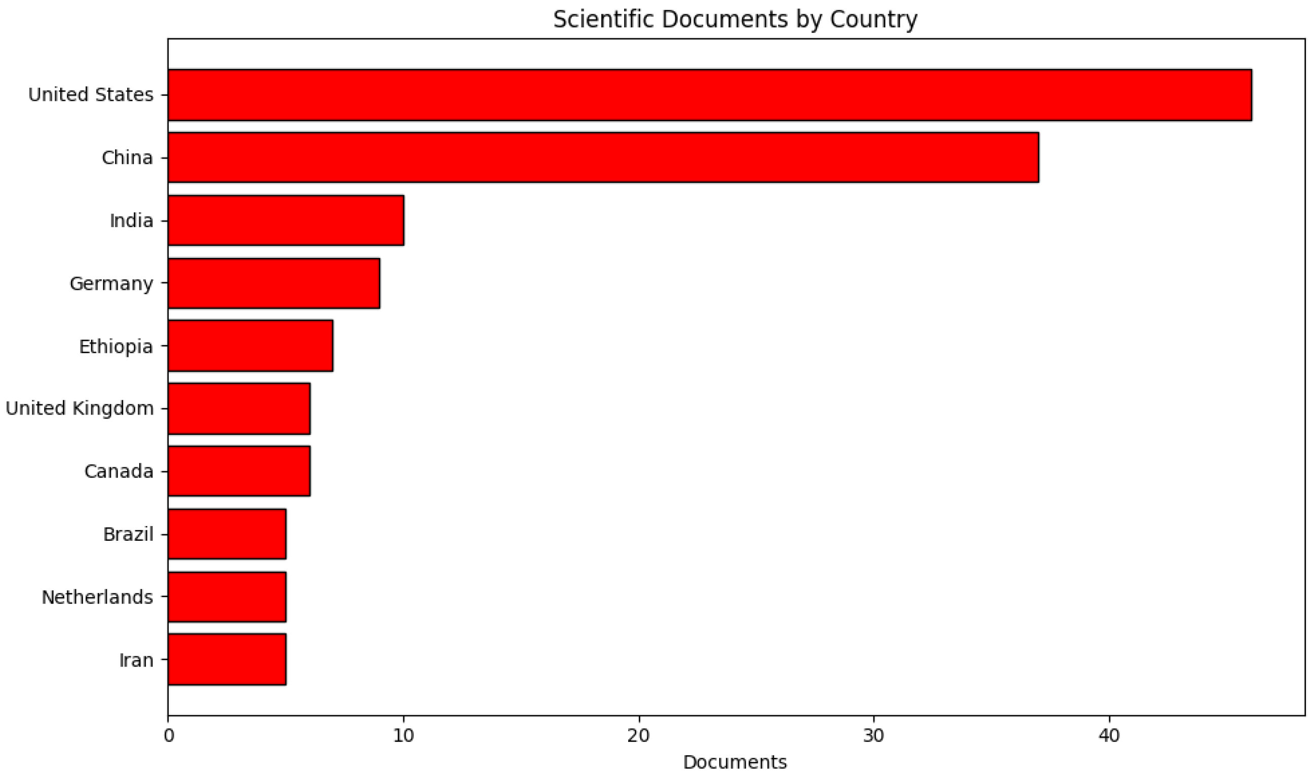
Table 2.
Inclusion Criteria for the Selection of Scientific Articles in the Systematic Review.
| Item | Inclusion Criteria |
|---|---|
| IC1 | The published and peer-reviewed studies must refer to hydraulic modeling. |
| IC2 | The published and peer-reviewed studies must discuss riverbank or flood defense systems. |
| IC3 | The published and peer-reviewed studies must present patterns of precipitation, river discharge, or the management of vulnerable areas. |
| IC4 | The published and peer-reviewed studies must report results from hydraulic modeling in river basins for the purpose of flood defense design. |
| IC5 | The published and peer-reviewed studies must fall within the five-year time frame from 2020 to 2025. |
Table 3.
Exclusion Criteria.
| Item | Exclusion Criteria |
|---|---|
| EC1 | Published and peer-reviewed studies that are not open access. |
| EC2 | Published and peer-reviewed studies that are not related to hydraulic modeling in civil engineering. |
| EC3 | Published and peer-reviewed studies that do not correspond to scientific journal articles. |
Table 4.
Distribution of Selected Scientific Articles by Database Source.
| Database | Quantity | |
|---|---|---|
| Documents | Percentage | |
| ProQuest | 16 | 17% |
| Scopus | 76 | 83% |
| Total | 120 | 100% |
Table 5.
Selected scientific studies analyzed in this systematic review.
| Nº | Author(s) | Title | Year | Journal | Country/City | Tools | Source |
|---|---|---|---|---|---|---|---|
| 1 | Jadidoleslam, N., Goska, R., Mantilla, R., Witold, F. | Hydrovise: An open-source, non-proprietary software for hydraulic data and model visualization and evaluation | 2020 | ScienceDirect | USA | Hydrovise | [23] |
| 2 | Khaled et al. | Initial assessment of the groundwater flow and budget using GIS, MODFLOW-2005 and the FREEWAT modeling tool in Bouteldja coastal aquifer (Northern East of Algeria) | 2021 | PagePress Publ. | Pavia | MODFLOW-2005 and FREEWAT | [24] |
| 3 | Baek, S. et al. | Developing a hydrological simulation tool to design bioretention in a watershed | 2019 | ScienceDirect | Philippines | Proprietary modeling software | [25] |
| 4 | Hussain, Z. et al. | Climate change and hydrological regime of the upper Indus basin under extreme climate scenarios | 2021 | ScienceDirect | Pakistan | MIROC5 and MPI-ESM-LR | [26] |
| 5 | Buddika, D., Coulibaly, P. | Identification of hydrological models for operational flood forecasting in St. John’s, Newfoundland, Canada | 2020 | ScienceDirect | Canada | SAC-SMA, GR4J, HEC-HMS | [27] |
| 6 | Halwatura, D., Najim, M. | Application of the HEC-HMS model for riverbank defense simulation in a tropical watershed | 2013 | ScienceDirect | Kelaniya | HEC-HMS | [28] |
| 7 | Gumindoga, W. et al. | Ungauged runoff simulation in Upper Manyame catchment, Zimbabwe: Application of the HEC-HMS model | 2017 | ScienceDirect | Zimbabwe | HEC-HMS | [29] |
| 8 | Tamiru, H., Teshome, T., Rientjes, T. | Flood forecasting in Niger-Benue basin using satellite and quantitative precipitation forecast data | 2016 | ScienceDirect | Netherlands | HEC-HMS | [30] |
| 9 | Cabrera, J., Castro, L., Crespo, P. | Evaluation of the HEC-HMS model for the hydrological simulation of a paramo basin | 2019 | Dialnet | Colombia | HEC-HMS | [31] |
| 10 | Lopez, J. et al. | Caracterización del modelo HEC-HMS en la cuenca de río Arga en Pamplona y su aplicación a cinco avenidas significativas | 2022 | Scopus | Spain | HEC-HMS | [32] |
| 11 | Sari, P. | Performance of Retarding Basin in Flood Disaster Risk Mitigation in Welang River, East Java Province, Indonesia | 2018 | UGM Repository | Indonesia | HEC-HMS | [33] |
| 12 | Duong, P. et al. | Assessment of climate change impact on river flow regimes in the Red River Delta, Vietnam: Case study of Nhue-Day River basin | 2017 | JNRD | Vietnam | HEC-HMS | [34] |
| 13 | Tu, H. et al. | Flash Flood Early Warning Coupled with Hydrological Simulation and the Rising Rate of the Flood Stage in a Mountainous Small Watershed in Sichuan Province, China | 2020 | Scopus | China | HEC-HMS | [35] |
| 14 | Amrei, D., Schmalz, B. | Flood hazard analysis in small catchments: comparison of hydraulic and hydrodynamic approaches using river defenses | 2020 | Scopus | Germany | HEC-HMS, HEC-RAS | [36] |
| 15 | Baduna, M., Akay, H., Melih, A. | Estimación de áreas vulnerables a inundaciones en zonas urbanas: Morelia, Michoacán, México | 2017 | Scopus | India | HEC-HMS, HEC-RAS | [37] |
| 16 | Alarcón, A. et al. | Estimation of flood-vulnerable areas in urban zones: Morelia, Michoacán, Mexico | 2020 | Scopus | Mexico | HEC-HMS | [38] |
| 17 | Wulan, L. | The Use of Rainfall Variability in Flood Countermeasure Planning | 2017 | Scopus | China | HEC-HMS, HEC-RAS | [39] |
| 18 | Ramos, A., Pacheco, J. | Análisis hidrológico e hidráulico de la cuenca del Río Frío, municipios de Ciénaga y zona bananera, departamento del Magdalena. | 2017 | Redalyc | USA | HEC-HMS, HEC-RAS | [40] |
| 19 | Rodriguez, S. | Dynamic flood simulation under maximum runoff conditions for five return periods, Quebrada La Virgen, San José de Miranda, Santander | 2017 | Scopus | USA | GIS; HEC-HMS; I-RIC | |
| 20 | Paudel, R., Basnte, K. | Application of HEC-HMS model for runoff simulation: A case study of Marshyangdi River Basin in Nepal | 2019 | Scopus | India | HEC-HMS, SWAT | [41] |
| 21 | Demetrio, A., Labate, A., Martino, D., Zimbone, M. | Comparing Different Infiltration Methods of the HEC-HMS Model: The Case Study of the Mésima Torrent (Southern Italy) | 2016 | Scopus | USA | HEC-HMS, Green-Ampt | [42] |
| 22 | Thu, K. | Development of Flood Inundation Map for Upper Chindwin River Basin By Using HEC-HMS and HEC-RAS | 2020 | Scopus | China | HEC-HMS |
Disclaimer/Publisher’s Note: The statements, opinions and data contained in all publications are solely those of the individual author(s) and contributor(s) and not of MDPI and/or the editor(s). MDPI and/or the editor(s) disclaim responsibility for any injury to people or property resulting from any ideas, methods, instructions or products referred to in the content. |
© 2025 by the authors. Licensee MDPI, Basel, Switzerland. This article is an open access article distributed under the terms and conditions of the Creative Commons Attribution (CC BY) license (http://creativecommons.org/licenses/by/4.0/).
Copyright: This open access article is published under a Creative Commons CC BY 4.0 license, which permit the free download, distribution, and reuse, provided that the author and preprint are cited in any reuse.


