
Submitted:
16 May 2025
Posted:
19 May 2025
You are already at the latest version
Abstract
Lower Silesia, one of Poland’s most popular regions among domestic and international tourists, is increasingly confronting overtourism at its primary attractions. This phe-nomenon poses significant threats to the region’s sustainable development, including disruptions in the functioning of local communities (e.g. by traffic jams), risks to tangi-ble heritage monuments, and potential visitor dissatisfaction. Concurrently, Lower Si-lesia possesses underutilized cultural assets, notably over 250 hillforts (Polish: grodziska) spanning various historical periods. This article aims to preliminarily assess the poten-tial of these hillforts for tourism development while proposing and testing a framework method for evaluating their potential for tourism use. The methodology combined desk research and field studies across all selected archaeological sites. Preliminary results from 25 surveyed hillforts suggest that most exhibit high potential for transformation into tourist attractions. The integration of hillforts into existing tourism infrastructure could significantly contribute to localized sustainable development across the region. By leveraging these heritage sites, communities get asset important in process of building common identity around cultural/historical place while safeguarding monuments. At regional scale the new attractions can help in mitigating overtourism pressures at overcrowded destinations. This approach aligns with strategies to disperse tourist flows through specialized archaeological tourism products, thereby balancing economic ben-efits with heritage preservation.
Keywords:
archaeological tourism (archaeotourism)
; sustainable tourism
; hillfort
; gord
; ring fort
; stronghold
; tourism potential
; lower silesia
1. Introduction
The emergence and development of archaeology is one of the greatest triumphs in the history of science. Initially, this discipline was associated with treasure hunting, but over time it became an advanced, multidisciplinary science, combining history, anthropology, ethnography, geography and many other fields [1]. Today, it is a vast and diverse science, studying everything: from primitive Paleolithic stone tools from millions of years ago to contemporary landfill deposits, so garbage thrown out just yesterday. It covers the entire world, allowing us to discover the human past based on its material traces, especially where other sources are silent. Archaeology as a powerful source of information, combined with elements of mystery and adventure, emphasized in numbers, popular science books and films [2], became an important dimension in tourism exploration.
Archaeological heritage can be divided into two subgroups: immovable archaeological remains, which include archaeological sites, and movable archaeological relics, named artefacts [3]. Both of these groups are currently being intensively utilized in tourism, driven not only by growing public interest in material heritage but also by archaeologists’ increasing awareness of the need to engage in public archaeology [4]. Researchers are recognizing the importance of democratizing heritage for societal benefit – particularly for descendant communities – enhancing public engagement, and leveraging tourism as a means to secure funding for research, excavations, and conservation efforts [5,6]. With some delay, however, a similar process is developing dynamically in Poland, as exemplified by interdisciplinary research and conferences devoted to the popularization of archaeology [7].
Poland as a destination is experiencing a post-pandemic “boom.” Tourist traffic indicators have risen rapidly in recent years, with 2024 being a record year: 38.8 million tourists were accommodated in tourist accommodation establishments, marking a 7.2% increase compared to 2023 [8]. Similar national trends are observed in Lower Silesia, one of the most popular regions for both domestic and international tourists. In 2023, 4.2 million tourists stayed in Lower Silesian accommodations (a 12.3% rise from 2022), making it the third most visited destination in Poland [9].
It is noteworthy that travel trends among Polish tourists align closely with those observed in other affluent European nations. Millennials are increasingly dominating the market as a key demographic, exhibiting a pronounced preference for off-the-beaten-track travel. This cohort predominantly favors emerging destinations perceived as offering “authentic” cultural experiences [10]. Such travel patterns may concurrently contribute to sustainable tourism practices, as these travelers consciously avoid overcrowded destinations impacted by overtourism, opting instead for underdeveloped regions [11]. Furthermore, industry reports from Poland in 2024 highlight a significant trend: the rising preference of lesser-known destinations by tourists, where they can see care for the environment and are offered of local products. It is ranked as the second most prominent market shift [12]. This underscores a broader alignment between evolving consumer preferences and sustainability-driven tourism strategies.
While positive tourism indicators drive the region’s economic growth, they also bring challenges. Key attractions in Lower Silesia increasingly face overtourism, exacerbated by the lengthening tourist season. Examples include the Karkonosze Mountains [13], the Stołowe Mountains [14], and Wrocław – the regional capital – which was visited a record 6.2 million visitors in 2024 [15].
This pressure underscores the urgency of dispersing tourist flows through new attractions or tourism products, a strategy critical to sustainable tourism development. Among the region’s underutilized resources are its numerous archaeological sites, particularly hillforts (gords), which exhibit diverse and visually striking landscape features and are often located near existing tourist attractions and infrastructure. Combining the landscape features of the hillforts and their specific location with the observed trends among tourists related to the search for authenticity, contact with nature and traveling off the beaten track, the authors decided to explore whether these cultural heritage assets could form the basis for new attractions in archaeological tourism development, thereby reducing pressure on Lower Silesia’s most overcrowded destinations.
2. Literature Review
2.1. Archaeological tourism – definition, roles and impacts
Access to interpreted archaeological sites and collections has long been recognized as a catalyst for tourism development [16]. The utilization of archaeological resources – both movable (e.g., artifacts) and immovable (e.g., structures) – enables visitors to engage with preserved heritage in its original context, acquire knowledge through museum collections, and interact with materials they may have only marginally learned about in school.
Archaeological tourism is thus defined as an alternative form of cultural tourism that seeks to foster public interest in archaeological-historical monuments while advocating for their preservation [17]. Broadly conceptualized, it encompasses activities centered on ancient and historical sites, museums, and other archaeological resources [18,19]. Some definitions emphasize the centrality of archaeological objects, framing archaeotourism as “a form of heritage tourism that focuses on visits to archaeological sites, parks, and excavations, is sensitive to the delicate archaeological environment, and stimulates learning about past human activity” [20,21]. Additionally, an attempt has recently been made to fill another significant gap in theoretical research on archaeotourism. One of the latest studies focused on a concept definition of archaeological tourism products and their systematization in different types and components, which has not yet existed in the literature [22].
The utilization of archaeological sites as tourist destinations remains a contentious topic, primarily due to their physical fragility and the divergent – often conflicting – visions for leveraging their vast interpretive potential. On the other hand, heritage tourism is also an incredible opportunity for archaeologists to reach out to the public, educate them and nurture their interest not only in the history and prehistory of individual sites, but also in the methods, professional ethics and current issues of archaeology [23].
Archaeological tourism, like cultural heritage tourism more broadly, is widely recognized as a developmental tool, delivering economic, social, and environmental benefits to destinations [24,25,26]. From an economic perspective, it drives revenue diversification, generates tax income, safeguards cultural resources as economic assets, and incentivizes entrepreneurial engagement in tourism markets [27]. Beyond preserving local traditions, heritage tourism fosters community identity and pride, creates authentic visitor experiences, and stimulates investment in tourism infrastructure and services [28].
The Archaeological Institute of America (AIA) answers the question “why do we need archaeology?” by pointing to several its core spheres of impact [29]: fostering tourist engagement through a blend of intellectual curiosity, adventure, and discovery; generating economic revenue; enhancing destination visibility among travelers; and empowering local communities through heritage-driven pride. Empirical studies corroborate that well-structured archaeotourism initiatives incentivize local communities to co-design complementary programs or participate directly in archaeological site management [30,31,32,33,34]. Archaeological tourism is therefore an opportunity for the synergic development of the community and the region, and when it is well-organized, it encourages full participation and cooperation of stakeholders, mainly local businesses and citizens.
One of the most frequently discussed functions of archaeological heritage in tourism is its educational role [35,36,37,38,39]. This role extends beyond traditional, direct engagement with the past to include enabling tourists to learn from the past and acquire knowledge about heritage management. The proliferation of active educational methods, increasingly integrated into tourism, provides visitors the interpretation of heritage, thereby fostering deeper engagement with historical narratives [40]. The significance of this educational function has grown rapidly in the 21st century, driven by societal transformations linked to the widespread adoption of new technologies. These shifts have reshaped tourist expectations, particularly in nations where archaeological heritage holds a well-established cultural position (e.g., the United Kingdom, Germany, the Netherlands, and the United States). Museums, archaeological sites, and heritage parks in these contexts now employ digital and interactive media – such as virtual platforms, mobile applications, and holograms – alongside sensory demonstrations, immersive storytelling, experimental reenactments, and performance arts (theater, dance) to facilitate multisensory engagement with artifacts [41,42].
The treatment of archaeological sites as economic resources entails numerous adverse consequences. One of the most extensively studied and documented issues is the physical degradation of heritage structures, particularly those inscribed on the UNESCO World Heritage List [43]. Continuous monitoring of iconic sites has yielded empirical evidence of the impacts of tourist activity. Notable examples include Machu Picchu [44] and the Cusco region [45] in Peru, Petra in Jordan [46,47], and Angkor Wat in Cambodia [48]. Based on global research and expert assessments, the International Council on Monuments and Sites (ICOMOS) has concluded that unregulated tourism at many sites causes irreversible damage to both the historic fabric of the monuments and their surrounding environments. This deterioration stems from erosion induced by visitor foot traffic, the use of animals (e.g., donkeys) for tourist transportation, and microclimatic changes in humidity and temperature – particularly detrimental to enclosed structures. In addition, there are problems with deliberate vandalism, manifested through graffiti [49,50] or the theft of structural elements, such as stone fragments [51]. Indirectly linked to tourism is the threat posed by infrastructural expansion. Protective measures for ruins, the designation of visitor pathways through sites, and the construction of adjacent tourist facilities – while intended to enhance accessibility – pose a risk of altering the character and landscape of heritage monuments, with extreme cases threatening their integrity [52].
2.2. Sustainable development and archaeotourism
The question of impacts and other aspects related to the functions of archaeotourism – including its economic and social roles – are now examined, like nearly all forms of cultural tourism, through the lens of sustainable development. In the 1980s, a clear trend in conservation doctrine emerged: from the notion of “care and protection of monuments” towards a new approach - the management of archaeological resources [53]. This perspective aligns with the principles of sustainable development, wherein heritage is simultaneously an object of preservation and a potential to be adaptively utilized for cultural, economic, and social advancement.
As S. Wurz and J. Van der Merwe [54] observe, archaeotourism must demonstrate a level of understanding and sensitivity toward its resources comparable to that of ecotourism in relation to pristine wilderness areas. Consequently, scholars propose grounding the development of sustainable archaeotourism in frameworks established for ecotourism, particularly the guidelines outlined in the Quebec Declaration on Ecotourism (2002) and synthesized in the publication Ecotourism: Principles, Practices, and Policies for Sustainability [55]. With respect to archaeological assets, sustainability in archaeotourism ought to:
“contribute actively to the conservation of natural and cultural heritage; include local and indigenous communities in its planning, development and operation, and contribute to their wellbeing; interpret the significance and meaning of the natural and cultural heritage of the destination for the visitor’s experiential benefit; lend itself better to independent travellers as well as to organized tours for small-size groups” [54] (p.11).
The aforementioned points clearly demonstrate that sustainable development and the utilization of sensitive archaeological resources in tourism necessitate a balance between the needs of the tourism industry and the management of archaeological heritage [56,57].
In this context, a critical issue is the growing – though still insufficient—recognition of the potential utility of lesser-known heritage sites located outside major tourist areas. One such analysis, presented in a dissertation examining the tourism potential of archaeological sites in the Iraq al-Amir region of Jordan [58], highlights results achieved through collaboration with local communities. Another notable case, where local schools play a pivotal role, is the proposal for a management plan for small and poorly visible sites in Al Ain in the United Arab Emirates [59]. A further example is the analysis of opportunities to diversify tourism offerings using immovable archaeological heritage in the Eilat region of Israel – a popular destination primarily known for natural attractions such as its climate, coral reefs, and desert landscapes [60]. Recent studies have examined the tourism potential of peripheral archaeological sites within the Madrid region. This study employs a systematic procedure to exploit the data gathered from Twitter and Flickr, in order to map the archaeological spaces that are shared in these user communities so as to assess the perception that the visitors have of them [61].
The integration of less prominent sites, particularly those adjacent to major attractions, is increasingly recommended in tourism development plans. The aim is to construct a “regional narrative” based on multiple archaeological sites, enhance the promotion of local heritage, and – from a conservation perspective – mitigate the adverse impacts of mass tourism on heavily frequented monuments [62]. These objectives align with the framework of the research presented in this article, which encompasses the entire Lower Silesia region.
A key stakeholder in sustainable archaeological tourism is the tourists themselves. However, early studies on this group were fragmented and limited in scope [6,63,64]. Only in recent years has this gap begun to be addressed [65,66,67], culminating in efforts to define the “archaeotourist” as a distinct category within cultural/heritage tourism. This conceptualization explores the interplay between archaeological heritage, archaeological knowledge, and the expectations and experiences of visitors to archaeological destinations [68].
2.3 The issue of archaeological site valuation and the methods for assessing tourism potential
A central theme within the scholarly discourse on the development and management of archaeological sites concerns the debate over criteria and metrics for assessing the value of these cultural assets. This debate has persisted for at least four decades, originating predominantly in American archaeology [69] and British archaeology [70], where it is closely tied to the concept of “significance.” In other countries, this issue has not been openly discussed until recently, which does not mean that assessments of archaeological monuments based on subconscious and intuitive criteria have not been made [71].
The aforementioned valorizations, shaped from the perspectives of the archaeological community, historically prioritized the determination of scientific value. A critical limitation of this approach lies in its treatment of scientific value as an inherent property of a archaeological site, when in reality, such value is ascribed by specialists and may change with the development of research. Consequently, the process of assigning value to archaeological sites has generated significant controversy, epistemological uncertainties, and methodological challenges. In response, scholars have proposed theoretically objective evaluation criteria, such as site size or stratigraphic depth, as potential solutions. However, these criteria themselves remain subject to critique for oversimplifying the complexities of cultural heritage valuation [72]. This discourse underscores the tension between subjective scholarly interpretation and the pursuit to formulate standardized criteria in heritage management, reflecting broader disciplinary debates about the interplay of objectivity, expertise, and cultural significance.
M. Glassow [73] proposed that “neutral” evaluation criteria for archaeological sites should include factors such as internal diversity, artifact density, site integrity, and the potential to generate data on environmental context. Concurrently, other American archaeologists advocated for metrics including site size (or spatial extent), stratigraphic depth, functional diversity, ecological context, preservation status, prior documentation, uniqueness, and chronology [71]. In England, to standardize and streamline valorization procedures, the Secretary of State published a set of eight non-statutory criteria in 1983 for determining the “national importance” of archaeological monuments. These included: survival, period, rarity, vulnerability, documentation, group and potential. Subsequently, English Heritage expanded the application of these criteria and introduced additional parameters in its Monuments Protection Programme. The revised framework categorized valuation criteria into three groups: characterization (e.g. period, diversity/form), discrimination (e.g. association value, potential), and assessment (e.g. condition, fragility) [74].
In discussions concerning the integration of archaeological sites with tourism, one of the most frequently cited methodologies is the Heritage Asset Sensitivity Gauge (HASG) developed by S. Wurz and J.H. Van der Merwe [54]. This framework was designed to facilitate the sustainable development of archaeological tourism in a western province of South Africa. The tool categorizes evaluation criteria into three broad groups, each containing ten indicators: market appeal, cultural significance, and site vulnerability. The authors emphasize that HASG builds upon earlier models proposed by H. du Cros [75] and subsequent modifications by McKercher and du Cros [76].
Another significant framework for valorizing archaeological heritage in tourism contexts is B. Mazzola’s [77] methodology. There are two important aspects of this method to be highlighted. Firstly, the author describes it as “evolutionary rather than revolutionary” approach because it synthesizes three pre-existing models: the Recreational Opportunity Spectrum (ROS), Tourism Opportunity Spectrum (TOS), and Ecotourism Opportunity Spectrum (ECOS). They are adapted into a new model termed the Archaeological Tourism Opportunity Spectrum (ATOS), incorporating most of the factors used in the original tools due to their proven efficacy in practice. Moreover, the application of the ATOS will provide specific tourism classes for archaeological sites based on user expectations. The preliminary step preceding formal evaluation involves classifying tourists based on a synthesis of multiple typological analyses, ultimately distinguishing four distinct categories: casual tourist, intermediate tourist, informed tourist, and expert tourist. Each typology evaluates the same set of criteria pertaining to archaeological sites, albeit through distinct “lenses”. The evaluated parameters encompass: access to a site, on-site development (type and scale of infrastructure), interpretation (modes of informational presentation), site protection and social interactions at the site.
A benefit of such visitor-centric research lies in its capacity to inform site management strategies that align with heterogeneous visitor expectations. The methodologically rigorous selection and validation of these criteria prompted the authors of the present study to integrate a subset of them into their proposed framework for assessing the tourism potential of hillforts. This adaptation aims to balance scholarly rigor with practical applicability, ensuring that heritage valorization processes remain responsive to both conservation priorities and evolving tourism needs. Both methods, HASG and ATOS, underscore the interdisciplinary nature of archaeological tourism planning, integrating socio-economic, cultural, and conservation priorities within structured evaluative systems.
Given the shared characteristics between archaeological and geological heritage, coupled with the relatively limited methods for assessing the tourism potential of archaeological sites, this study draws upon the extensive literature evaluating the potential and attractiveness of geotourism sites. Numerous publications offer original criteria proposals [78,79,80,81,82,83], as well as comparative analyses of diverse evaluation tools [84,85]. A further advantage of geotourism methodologies lies in their preparation and application to Lower Silesia [86,87,88,89,90].
The analysis of these works provided insights into varied approaches to structuring evaluations, expanded the range of criteria, and clarified their relevance to different user groups. By identifying the most significant and recurring criteria and cross-referencing them with indicators used in archaeological heritage assessments, the authors of this article could have developed the method proposed herein for evaluating the tourism potential of hillforts.
A review of diverse methodologies for valorizing archaeological sites, or any other cultural and natural resources, whether oriented toward scientific or tourism objectives, reveals significant challenges in selecting appropriate criteria and determining their relative weight in evaluation processes. While scientific valorization criteria are frequently subject to critique, many remain indispensable in tourism-focused assessments due to their role in comprehensively defining a site’s heritage value. Beyond scientific metrics, such as the state of preservation (a key determinant of a monument’s informational potential), tourism-oriented valorization necessitates the inclusion and prioritization of additional factors. These encompass societally valued elements, including site accessibility and the quality of tourist infrastructure in its vicinity, which are critical for aligning heritage management with public engagement and visitor expectations.
This dual emphasis underscores the need for evaluative frameworks that integrate both scholarly rigor and community-centric considerations, ensuring that heritage valorization reflects not only academic priorities but also the practical realities of sustainable tourism development.
3. Materials and Methods
3.1. Study area
The study area encompasses the region of Lower Silesia (Polish: Dolny Śląsk), located in south-western part of Poland which is defined here within the administrative boundaries of the Lower Silesian Voivodeship (Figure 1). Both terms are used interchangeably throughout this article. While the physical-geographical and cultural boundaries of Lower Silesia are variably demarcated and often diverge from the voivodeship’s administrative area, the approach in this study is justified by two arguments. First, tourism development and management in Poland are primarily administered by local governance units (e.g., voivodeships), making this administrative framework relevant for applying the research outcomes into practice. Second, sustained regional identity-building initiatives within the voivodeship have increasingly conflated the term “Lower Silesia” with the administrative unit (voivodeship) in public discourse.
Hillforts (grodziska) are distributed across all the region, reflecting divergent settlement patterns from prehistory to the late medieval period, as well as terrain-dependent variations in fortification typologies. To address these spatial and morphological complexities, the voivodeship was subdivided into three zones based on terrain morphology, demarcated by physical-geographical macroregion boundaries (Figure 2):
- Southern Zone (SZ): Comprising mountainous areas, foothills, and foreland regions (Sudetes, Western Sudetes Foothills, and Sudetes Foreland).
- Central Zone (CZ): Encompassing lowland areas in the regional core (Silesia-Lusatia Lowlands and Silesia Lowland).
- Northern Zone (NZ): Including the Trzebnica Range, Milicz-Głogów Depression, and fragments of other physical-geographical units.
This zoning does not fully align with historical settlement networks, the territorial ranges of specific archaeological cultures, or medieval tribal boundaries. Instead, it is designed to facilitate the study’s primary objective: a preliminary assessment of archaeological sites’ suitability for tourism in different, generalized terrain zones, rather than settlement pattern analysis.
The authors posit that the division into zones allow for testing the universality of the method, i.e. checking the possibility of its application to the same types of monuments, but located in regions with different forms of relief (mountains, foothills, lowlands). At the same time, it will allow for verification whether the criteria selected in the method do not overlook important features of hillforts in a given group (zone), which may affect their tourist potential, and in the absence of their assessment - would automatically lower the score for a given object. This assumption also works the other way round, i.e. it aims to check whether some of the features of the environment, resulting from the location in a given zone, do not cause a falsely high score for the assessment of the site.
3.2. Subject of research
The archaeological sites under examination are referred to in Polish as grodziska – a term denoting the remnants of fortified settlements known as grody. In English translations, these objects are named differently depending on their chronological and geographical context. For instance, upland and submontane fortifications are typically termed hillforts [91], while lowland fortifications associated with Slavic settlement traditions are often described as ring forts [92]. Additional terminological varia-tions in the literature include strongholds [93,94], earthworks, motte-and-bailey castle [95], and sometimes burgwall, referring to German term (German: Burgwalle), literally meaning “fort rampart”. Most of these terms are used to reflect distinct architectonic/morphological attributes, sometimes related to a specific time period and/or region.
To streamline analytical discourse and mitigate terminological ambiguity, this study adopts the dual nomenclature: hillfort or gord (from Polish term gród) as universal designators for all such sites within Lower Silesia. This terminological rule is applied irrespective of terrain type (mountainous, foothill, or lowland) and spans the full chronological spectrum from prehistoric eras (the earliest recorded fortifications) to the late medieval period (15th–16th centuries).
3.3 Aims and research questions
The primary objective of this research is to conduct a preliminary assessment of the potential use of hillforts as heritage tourism attractions. This entails a systematic evaluation of the touristic potential inherent in selected archaeological sites across geographically and topographically diverse zones within the voivodeship. The methodological framework integrates a multi-criteria analysis presented in subsection of research methods.
Based on the inventory of archaeological sites in the Lower Silesian Voivodeship and Poland, as well as insights into key challenges in archaeotourism (as identified in the literature review), the following research questions were formulated:
- How many of the numerous hillforts in Lower Silesia exhibit high tourism potential, enabling their transformation into viable attractions?
- If the southern part of Lower Silesia is the most touristically attractive region, do hillforts in this area also demonstrate the highest tourism potential?
- Which variables are most critical to include in a preliminary assessment of hillforts for tourism development?
Guided by these questions, the study established primary and secondary objectives, alongside two hypotheses.
Primary Objective:
To evaluate the preliminary viability of integrating hillforts into tourism frameworks. This involves an initial assessment of the tourism potential of selected archaeological sites across the voivodeship, analyzed through criteria such as:
- Physical and morphological attributes,
- Accessibility and proximity to infrastructure,
- Conservation status,
- Representation in tourism literature and digital media.
Secondary Objective:
To develop and test a standardized methodology for assessing the tourism potential of hillforts, ensuring universal applicability across diverse typologies of these fortifications.
Hypotheses:
H1: Due to the distribution of hillforts across zones with distinct terrain morphologies, hillforts exhibit significant variations in tourism potential scores.
H2: Hillforts in the southern zone achieve the highest tourism potential ratings, reflecting the region’s established reputation as Lower Silesia’s most touristically attractive area.
3.4. Resources and research methods
The preliminary inventory and identification of attractions were conducted through desk research utilising secondary sources. Key resources included the Archaeological Heritage Inventory and the Register of Archaeological Monuments. These official registries were supported by archaeological literature addressing sites from various periods, notably the early Middle Ages [92,93,97,98] and the late Middle Ages [99]. They were supplemented by works presenting the latest recognised sites [91] and tourism analysis of the archaeological sites in the region [100].
Tourism potential assessments incorporated data from geoportals (https://mapy.zabytek.gov.pl/nid/; http://geoportal.dolnyslask.pl/), including LiDAR layers and digital/printed tourist maps (mapa-turystyczna.pl, mapy.cz).
Stratified Proportional Sampling: A representative subset of 10% of all identified hillforts was selected, ensuring proportional representation from each of the three zones relative to their distribution across the voivodeship.
Systematic Sampling: To avoid geographical bias, a maximum of two sites per poviat were initially chosen.
Random Sampling: Final site selection was randomized to mitigate spatial clustering effects.
As part of the field research, all sites were visited to document their landscape characteristics, surrounding areas and accessibility, as well as photographic documentation were performed.
Data analysis (descriptive statistics: mean, median, standard deviation) and visualization (most figures) were prepared using Excel and QGIS.
The text is the original work of the authors, but generative artificial intelligence was used to improve it (grammar, selection of professional terms).
3.5. Assessment method of tourism potential of hillfort
To achieve the primary research objective, a methodological framework was developed to evaluate the tourism potential of hillforts. This tool employs a weighted scoring system, wherein distinct criteria are assigned numerical values, with the aggregate score reflecting the site’s overall potential. The proposed framework categorizes evaluation criteria into three principal groups (Table 1):
- Physical characteristics,
- Surroundings and accessibility,
- Information visibility.
Detailed information of variables within each category, alongside their scoring system and descriptions of indicators, are provided in Appendix A.
Sites get points for attributes that enhance their touristic appeal, with the magnitude of points contingent on the quality of the assessed feature (i.e., higher scores correspond to more favorable attributes). The maximum achievable score across all criteria is 75 points, representing maximum (very high) tourism potential.
Tourism potential was stratified into four tiers based on percentile thresholds relative to the total attainable score (Table 2).
4. Results and Discussion
4.1. Inventory of hillfords in Lower Silesia
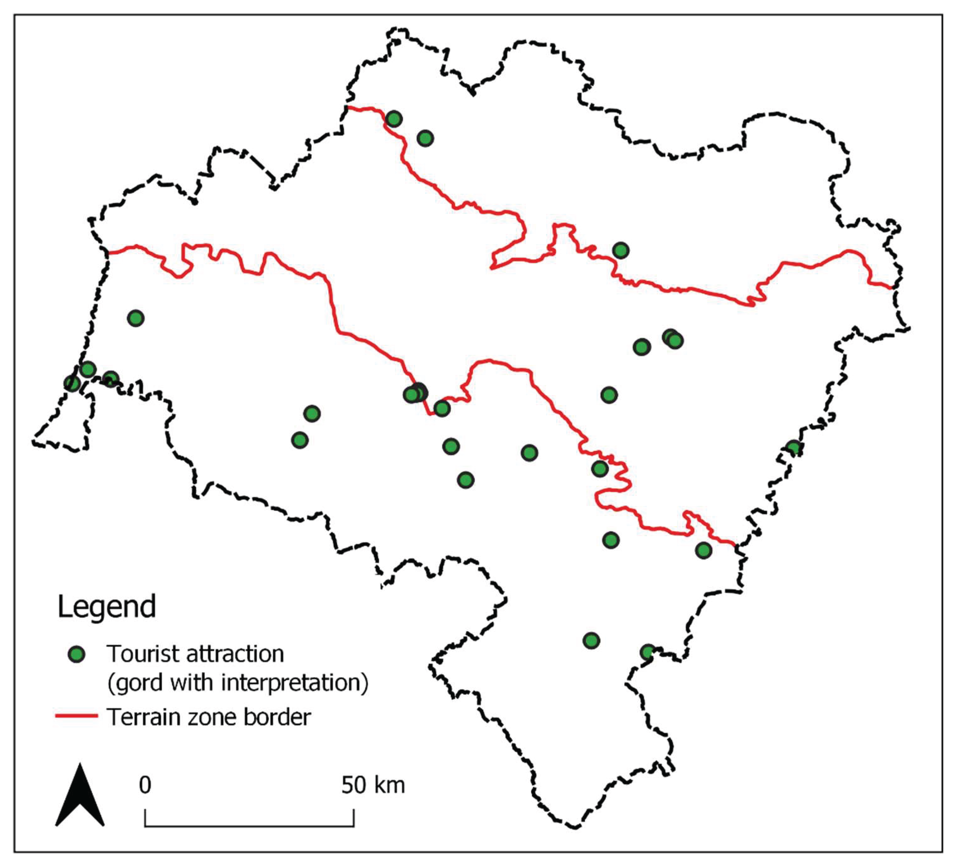
The inventory process identified 280 existing, confirmed, or presumed hillforts. Among these, 29 sites qualify as formal tourist attractions under N. Leiper’s definition [101], characterised by physical infrastructure such as educational signage enabling their recognition and identification in situ (Figure 4). Among the identified heritage attractions, a pronounced spatial concentration is evident: 19 sites (65%) are located in the Southern Zone, 7 in the Central Zone, and only 3 in the Northern Zone. This distribution highlights significant disparities in tourism infrastructure development across the voivodeship’s geographical sectors.
Figure 4.
Distribution of hillforts classified as tourist attractions (objects with physical interpre-tation in situ; N=29). Source: own elaboration.
Figure 4.
Distribution of hillforts classified as tourist attractions (objects with physical interpre-tation in situ; N=29). Source: own elaboration.
After excluding developed attractions, 251 hillforts remained as potential tourism assets. Their spatial distribution across the voivodeship is approximately uniform (Figure 5). Specifically:
- Southern Zone: 88 hillforts (35% of the total),
- Central Zone: 93 hillforts (37%),
- Northern Zone: 70 hillforts (27%).
A stratified sampling was applied, selecting 10% of non-developed hillforts from each zone to ensure proportional representation. This yielded:
- 9 hillforts from the Southern Zone,
- 9 from the Central Zone,
- 7 from the Northern Zone.
4.2. Tourism potential assessment of selected hillfords
The results demonstrate that the majority of sites (19 hillforts) exhibit high tourism potential (Figure 7), with one site (Trzebnica, st. 3) classified as having very high potential. Notably, no hillforts were rated at the low level. Detailed scores across all criteria for individual sites are presented in Table 4.
The mean aggregate score was approximately 49 out of 75 (65% of the maximum achievable points), with a standard deviation of 4.70 points. Category-specific performance for all sites together reveals the following average results:
- Category 1 (Site Characteristics): 70% of maximum points (ca. 29/40),
- Category 2 (Surroundings and Accessibility): 60% (ca. 15/25),
- Category 3 (Information Visibility): 56% (ca. 5,6/10) (Table 5).
Zonal comparisons indicate that hillforts in the northern zone achieved the highest average scores, while the southern and central zones produced nearly identical results (Figure 8). However, mean scores across all three zones were closely clustered, differing by less than 3%. Northern zone sites outperformed others in categories 1 and 2, whereas southern zone sites demonstrated superior performance in category 3.
4.3. Physical characteristics assessment
The mean rating in the category of physical characteristics of the sites for all examined objects is 27.84, with a median of 28 (Table 5). Hillforts from the central and northern zones scored above the mean, while those from the southern zone scored slightly below, though the differences in results are marginal.
All sites, except one (Niemstów, site 6), are listed in the register of archaeological monuments. This ensures their proper protection, which will preserve their landscape form and facilitate future research, thereby contributing new data for tourist interpretation. This is particularly significant, as 17 out of 25 hillforts are confirmed to have functioned for at least one century, while 8 sites exhibit evidence of at least two settlement phases (spanning a minimum of two centuries). Consequently, future studies are expected to expand chronological knowledge of these hillforts, which is crucial for enhancing the quality of narratives developed for tourists [53].
The southern zone demonstrates the poorest research status (average rating of 2.89 out of 6), whereas the northern zone shows the best-researched monuments (average score of 4.86). This indicates that despite hosting the highest number of tourist attractions, including archaeological sites (Figure 4), the southern zone remains archaeologically understudied in some aspects, limiting broader tourist interpretations of the earliest history of this part of Lower Silesia.
The central zone achieved the highest scores in criteria related to preservation and structural complexity, exemplified by sites in Krajów, st. 2 (Figure 9), and Kadłub, st. 3 (Figure 10).
The analysis reveals that complex sites achieving the maximum score are also present in other zones. In the mountainous zone, these include hillforts at Marczów, st. 1, and Chałupki, st. 1, while in the northern zone, Bełcz Mały, st. 1, and Bukowinka, st. 1, attained top ratings (Figure 11a).
Regarding site visibility, all zones demonstrated comparable results (2.44 out of 3), with good visibility maintained across seasons, including autumn-winter and spring-summer periods (Figure 11). Although hillforts are typically associated with rural, forested landscapes, several selected sites are situated in urbanized areas and remain visually prominent (Figure 12). These factors significantly influence the potential to integrate the sites into tourism products aimed at distributing visitor traffic more evenly throughout the year, thereby supporting sustainable tourism development [102]. This aligns with environmental objectives by reducing overcrowding and facilitating site conservation, while also addressing economic goals through off-season tourist activity [103].
The prominence criterion yielded the highest scores in the northern zone (5.44 out of 6), attributable to the distinctive terrain conditions shaping fortification structures. However, lowland areas in the central and northern zones also achieved relatively high scores (mean above 4 out of 6; Table 5). This indicates that all selected sites possess clearly defined landscape forms (Figure 13), a critical factor in enhancing their archaeological tourism potential. The unique characteristics of hillforts, particularly their construction elements (ramparts), are emphasized as a key for attracting tourists , with greater relief variations on site correlating to higher visitor appeal [104].
In the viewing point category, all three zones received low average scores (below 1.5 out of 3), a surprising result given the mountainous zone’s expected panoramic potential. This discrepancy stems from the majority of hillforts being located within or adjacent to forested areas, which typically lack scenic values. Such findings underscore the limited integration of visual landscapes into current site evaluations despite their theoretical significance for tourism [105].
4.4. Assessment of surroundings, accessibility and information visibility
The highest mean scores in the accessibility and surroundings category were rec-orded for sites in the northern zone, while the lowest were in the central zone (Table 5).
All 25 surveyed sites are located in open, public, and freely accessible areas, a crit-ical positive factor enhancing their tourism potential.
In the proximity to tourist trails and site accessibility criteria (nearby roads and paths), results were similarly favorable, with northern zone sites achieving the highest scores in both categories. Of the 25 sites, nearly half (12 hillforts) are intersected by at least one tourist trail (5 sites each in the southern and northern zones). Only 4 sites (out of all) lack a tourist trail within a 500-meter radius. The presence of trails on or near hillforts (≤500 m) significantly supports sustainable infrastructure development, as it eliminates the need for additional investments and enables cost-effective integration of these sites into existing tourist attractions [106]. Furthermore, all sites are accessible via at least a visible footpath, with 25% (6 sites) adjacent to asphalt roads and 44% (11 sites) near well-visible unsealed roads (field or forest tracks).
Each hillfort is located within a 1-hour walk (≤5 km) of the nearest bus stop or train station. Ten sites are within 1 km, while 15 are 1–5 km away, most commonly exceeding 3 km. Despite this positive assessment, a key limitation arises from the fact that most of these stops are situated in small villages. Given the operational characteristics of rural public transport in Poland [107], this raises concerns about the reliability of schedules and the potential non-operational status of some stops, significantly undermining the credibility of this criterion.
The study revealed poor outcomes for the criterion of proximity to other archaeological sites. Proximity to archaeological attractions was documented in only two cases within the northern belt: the hillforts at Dankowice, st. 1, and Trzebnica, st. 3. In the first case, the nearby modestly developed hillfort in Jakubów was noted, while in Trzebnica, the archaeological attraction is the Winna Góra site, where the oldest traces of human activity in Polish territories were discovered. To disseminate this information, an educational trail was established [100]. For the remaining hillforts, this criterion received low ratings, as other archaeological sites are either absent or occur sporadically within a 5 km radius. This limitation significantly hinders the potential utilization of these resources for developing products tailored to archaeological tourism [22].
Better results were observed for the criterion of proximity to other tourist attractions, albeit primarily those of regional or local significance. Notably, all 25 analyzed sites are located within 5 km of at least one attraction. Specifically, one hillfort lies within 1 km of a supra-regional attraction, another is similarly proximate to a regional attraction, and nine are in the immediate vicinity of local attractions. As with the criterion assessing proximity to trails, these findings suggest that the examined archaeological sites could be easily integrated into the existing tourism systems of their respective areas. That opportunity is important factor mainly for development of remote rural areas of the region [108]
The visibility criterion evaluated the extent to which awareness of selected heritage sites is reflected in tourist and specialist literature. Given the tourism-oriented focus of the research, greater emphasis was placed on the presence of information in tourist literature, as it serves as the primary resource for visitors. Within Category 3, the highest average scores were observed for sites in the southern belt (Table 5), a trend partially attributable to the extensive body of geographical and historical literature pertaining to the Sudetes region. However, northern belt sites scored highest for visibility in travel guides, surprisingly.
The study also examined the presence of sites on geocaching platforms, a globally popular form of active tourism combining cultural and adventure elements [109]. Among the 25 hillforts, geocaches were documented at seven (predominantly in the southern belt), with three additional sites having caches within 200 meters. The presence of geocaches indicates that these sites already attract visitors, positioning them as niche tourism attractions.
5. Conclusions
5.1. Final results and further research
Regarding the formulated hypotheses, the following conclusions were drawn:
- Hypothesis 1 (Due to the distribution of hillforts across zones with distinct terrain morphologies, monuments exhibit significant variations in tourism potential scores) was rejected. The mean scores for tourism potential across all three zones demonstrated negligible variation, indicating comparable levels of assessed value.
- Hypothesis 2 (Hillforts in the southern zone achieve the highest tourism potential ratings, reflecting the region’s established reputation as Lower Silesia’s most touristically attractive area) was also rejected, as the northern zone yielded the highest mean scores.
Despite the rejection of both hypotheses, the primary research objective – a preliminary assessment of the tourism potential of hillforts in the Lower Silesian Voivodeship – was achieved. A significant majority of sites (19 out of 25) were classified as having high tourism potential. Notably, the mean score of ~49/70 points places this result near the lower threshold for the “high” category (45–59 points). Only one site attained a very high rating, while the remaining five fell into the moderate category.
These promising outcomes suggest the feasibility of transforming archaeological monuments into tangible tourist attractions, thereby supporting sustainable tourism development in the region [21]. The spatial distribution of underutilized hillforts across the voivodeship highlights opportunities to develop infrastructure in proximity to these sites, particularly in less frequented areas such as the northern, northwestern, and central lowland regions of Lower Silesia. Such initiatives could mitigate overtourism in popular zones while enabling local communities to derive economic benefits from increased visitor activity [4].
Furthermore, fostering community engagement in hillfort preservation – through educational programs, participatory conservation efforts, and heritage valorization – advances the social and environmental pillars of the triple bottom line framework. The former is realized by nurturing local patriotism and identity rooted in cultural heritage [27], while the latter enhances monument protection, as residents with strong ties to these sites often evolve into voluntary custodians [110].
Given the positive outcomes for most sites, the study recommends expanding research to encompass all inventoried hillforts, with particular emphasis on northern and central areas. These regions, frequently assessed as the least attractive in broader studies [96], stand to benefit most from archaeotourism products.
5.2. Evaluation of method and recommendations
The study enabled the testing and critical evaluation of the proposed methodology, yielding several conclusions and corresponding recommendations for methodological refinements.
Key observations:
- Source accessibility limitations - challenges arose in accessing up-to-date archaeological literature and artifact typologies due to the fragmented availability of publications. Additionally, the level of detail in excavation publications varied significantly across sites.
- Tourism potential beyond physical attributes - despite low ratings in physical characteristics for certain sites, their tourism potential remained considerable due to locational advantages, surrounding infrastructure, or contextual features. For example, hillfort in Boguszyn, physically combined with a religious landmark (chapel), equipped with accessible parking, and offering panoramic views – demonstrated high potential despite modest physical scores.
The proposed tool successfully emulated the multidimensional approach observed in established methodologies [78,79,80,81,82], proving effective for assessing tourism potential. However, the following revisions to the scoring system are recommended:
- expand or separate evaluative categories – differentiate between research history and artifact typology assessments to reduce conceptual overlap.
- integrate historical sources – introduce a criterion assessing historical written records, which are critical for constructing site narratives.
- evaluate structural remains – add a category for assessing preserved structural features (e.g., stone/brick constructions) that enhance landscape appeal.
- re-calibrate scenic value metrics – diminish the weight assigned to viewpoint assessments
- incorporate risk analysis: integrate criteria for safety considerations for both tourists (e.g., terrain hazards) and sites (e.g., visitor-induced degradation).
The tested methodology should serve as a preliminary screening tool for tourism potential. Sites yielding positive results warrant subsequent analyses focused on functional factors for heritage valorization, including:
- stakeholder engagement: assessing the willingness and capacity of local authorities and communities to participate in site stewardship.
- collaborative frameworks: evaluating partnerships with conservation and archaeological authorities to ensure alignment with preservation standards.
- interpretative feasibility: determining the viability of reconstructions and heritage interpretation strategies to enhance visitor engagement.
Author Contributions
Conceptualization, D.W. and K.W.; methodology, D.W.; software, not applicable.; validation, K.W.; formal analysis, D.W.; investigation, D.W.; resources, K.W.; data curation, D.W.; writing—original draft preparation, D.W. and K.W.; writing—review and editing, D.W.; visualization, D.W.; supervision, K.W.; project administration, D.W.; funding acquisition, K.W. All authors have read and agreed to the published version of the manuscript.
Acknowledgments
During the preparation of this manuscript, the authors used GenAI tool named PopAI for the purposes of refining text. The authors have reviewed and edited the output and take full responsibility for the content of this publication.
Conflicts of Interest
The authors declare no conflicts of interest.
Appendix A
Assessment method of tourism potential of hillfort - descriptions of criteria and indicators with scores
- Category 1: Physical characteristics (40 points).
| Criterion | Indicators and scores |
| Site status* | 4 – Confirmed archaeological site recorded in the Register of Archaeological Monuments 3 – Confirmed archaeological site listed in the Archaeological Heritage Inventory or presumed site recorded in the Register of Archaeological Monuments 2 – Confirmed site not recorded in Register or Inventory or presumed site recorded in the Archaeological Heritage Inventory1 – Presumed site recognized by specialists (archaeologists or related fields) but unregistered0 – Presumed site identified by amateurs (e.g., enthusiasts) |
| * In Poland, archaeological heritage is cataloged through two distinct tiers of documentation:1) Register of Archaeological Monuments (Rejestr Zabytków Archeologicznych) – the highest legal tier, comprising sites of exceptional historical, scientific, or cultural significance. 2) Archaeological Heritage Inventory (Ewidencja Zabytków Archeologicznych) – a comprehensive administrative list maintained at the voivodship (województwo) level, encompassing all identified archaeological sites regardless of significance. | |
| Chronology and archaeological cultures | 3 – A site with a confirmed chronology spanning ≥2 settlement phases and/or usage dating to ≥2 centuries and/or associated with ≥2 archaeological cultures2 – A site with a confirmed chronology spanning 1 settlement phase and/or usage dating to 1 century and/or associated with 1 archaeological culture1 – A site with tentative chronology/archaeological culture0 – A site with undetermined chronology/archaeological culture |
| Research, documentation, literature | 6 – Open-area excavations yielding abundant artefacts (incl. rare/unique), providing extensive knowledge about the site presented in documentation and/or publications5 – Open-area excavations yielding common artefacts, providing extensive knowledge about the site presented in documentation and/or publications4 – Test excavations (trial pits) with rare and common artefacts, providing significant verified knowledge about the site presented in documentation and/or publications3 – Test excavations (trial pits) with common artifacts providing significant verified knowledge about the site or surface surveys with rare finds, presented in documentation and/or publications2 – Surface surveys with common artefacts, providing basic knowledge about the site, presented in documentation and/or publications1 – Surface surveys without artefacts, with basic description in documentation and/or publications0 – No research, documentation, or literature |
| State of preservation | 4 - A well-preserved site without damage3 – A well-preserved site with minor damage (e.g., partial damage to earth walls or motte/mound)2 – The surface of the site is ≥50% preserved, retaining structural components, allowing typological identification1 – The surface of the site is ≥50% preserved, without structural components or the site is preserved <50% of the surface, but with structural elements (e.g. part of the earth wall)0 – A site destroyed by more than 50%, without characteristic elements or with elements of objects that are difficult to recognise and identify |
| Site complexity | 3 – Multi-component site with clear boundaries (e.g., fortified settlement with bailey/suburb and ditch/moat)2 – Two-component site with clear boundaries (e.g., gord in form of hill with ditch or earth walls)1 – Single-component site with clear boundaries (e.g., simple motte without ditch)0 – A site without clear boundaries, difficult to recognise in the landscape |
| Site size | 4 – Very large (>1 ha)3 – Large (>0.5 – 1 ha)2 – Medium (>0.1 – 0.5 ha)1 – Small (0.01–0.1 ha)0 – Very small (<0.01 ha) |
| Site visibility | The number of directions (sides) from the outside, from which the site can be observed:3 – Fully visible from all sides, ≥1 unobstructed view2 – Visible from ≥2 sides with minor obstructions1 – Visible from 1 side with minor obstructions0 – Visibility obstructed from all sides |
| Land cover | 3 – Open meadow/lawn or exposed terrain 2 – Mixed cover (meadow/forest) with sparse undergrowth or treeless area with dense vegetation (e.g. grass) partially obscuring the visibility of the structural elements of the site1 – Park/forest with sparse undergrowth0 – Park/forest with dense undergrowth (shrubs/tall grass) severely limiting visibility of the site |
| Site prominence** in the case of multi-component sites, the highest element/object is taken into account | Prominence above surrounding terrain6 – >4 m 5 – >3–4 m4 – >2–3 m3 – >1.5–2 m2 – >1–1.5 m 1– 0.5–1 m0 – <0.5 m |
| Viewpoint | 4 – On-site with a vast, multi-plan panorama3 – On-site with an average (e.g. single-plan) panorama2 – Within 100 m, with a vast, multi-plan panorama1 – Within 100 m, with an average (e.g. single-plan) panorama0 – At a distance of more than 100 m |
- Category 2: Surroundings and accessibility (25 points).
| Criterion | Indicators and scores |
| Land accessibility | 4 – Open area, fenceless, publicly accessible (e.g., state-owned forests, urban parks)3 – Open area, but with unclear ownership or private land, fenceless, with access permitted2 – Closed area (e.g. private land), no possibility of entering the site, but with the possibility of approaching the object directly and observing it easily1 – Closed area (e.g. private), no possibility of entering the site, possibility of easy observation of the site from a distance of up to 50 m0 - Closed area (e.g. private), no possibility of entering the site, possibility of limited observation from a distance of up to 50 m or observation from a distance of over 50 m |
| Proximity to tourist trails | 5 – At least 2 different trail types or at least 3 trails of one type crossing the site4 – 2 trails of one type crossing the site3 – 1 trail crossing the site 2 – ≤200 m from nearest trail1 – 200–500 m from nearest trail0 – >500 m from trails |
| Type of access (road, path) | 4 – Adjacent to the asphalt road3 – Adjacent to the unsealed road or within 100 m of an asphalt road with a clearly visible path2 – ≤100 m from the unsealed road with a clearly visible path to the site or >100 to 500 m from the asphalt road with a clearly visible path to the site1 – 100–500 m from the unsealed road with a clearly visible path to the site0 – >500 m from any road |
| Distance to public transport | Proximity to a train station or bus stop:2 – within 1 km 1 – >1 to 5 km0 – >5 km |
| Nearby archaeological sites | 3 – Within 5 km from at least 1 developed site (tourist attraction) or at least 1 site of another type2 – At least 2 tourism resources (undeveloped sites) within a distance of 5 km1 – At least 1 tourism resource (undeveloped site) within a distance of 5 km0 – No sites within 5 km |
| Proximity to tourist attractions | 5 – ≤1 km from supra-regionally significant attraction4 – ≤1 km from regionally significant attraction3 – ≤1 km from locally significant attraction2 – >1 to 5 km from supra-regional attraction1 – >1 to 5 km from regional/local attraction0 – >5 km from any attraction |
| Parking availability | 2 – ≤200 m from site1 – >200 m–1 km0 – >1 km |
- Category 3: Information visibility (10 points).
| Criterion | Indicators and scores |
| Type of information source(points added up, max 8 points) | +3 – A site presented in travel guides/travel portals+2 – A site presented in specialized historical/geographic sources (regional studies) or regional websites+2 – A site presented in open-access archaeological databases (e.g. zabytek.pl) or in archaeological publications +1 – Marked on tourist maps0 – No information or erroneous data, e.g. the site is marked on the map wrongly |
| Geocaching presence | 2 – Cache on-site1 – Cache ≤200 m from site0 – cache >200 m away |
References
- Bahn, P.G. Archaeology. The Essential Guide to Our Human Past, 1st ed.; Publisher: Smithsonian Books, Washington, DC, the US, 2017. [Google Scholar]
- Walker, C.; Carr, N. Tourism and archaeology: an introduction. In Tourism and archaeology. Sustainable meeting grounds; Walker, C., Carr, N., Eds.; Left Coast Press: New York, 2013. [Google Scholar]
- Kairišs, A.; Oļevska, I. Development Aspects of Archaeological Sites in Latvia. Arch. Lituana, 2021, 22, 10–36. [Google Scholar] [CrossRef]
- Timothy, D. J.; Tahan, L. G. . In Archaeology and Tourism: Touring the Past. In Archaeology and Tourism: Touring the Past; Timothy, D. J., Tahan, L. G., Eds.; Channel View Publications: Bristol, UK, 2020. [Google Scholar]
- Burtenshaw, P. Tourism and the Economic Value of Archaeology. In Archaeology. In Archaeology and Tourism: Touring the Past; Timothy, D. J., Tahan, L. G., Eds.; Channel View Publications: Bristol, 2020. [Google Scholar]
- McGettingan, F.; Rozenkiewicz, A. Archaeotourism—The Past is Our Future. In Cultural Tourism; Raj, R., Griffin, K., Morpeth, N., Eds.; CABI: Wallingford, 2013; pp. 118–128. [Google Scholar]
- Banasiak, P.; Wielocha, E. Sprawozdanie z ogólnopolskiej interdyscyplinarnej konferencji naukowej Forum Archeologii Publicznej. Popularyzacja i edukacja archeologiczna. In Forum Archeologii Publicznej. Popularyzacja i edukacja archeologiczna; Banasiak, P., Freygant-Dzieruk, M., Stawarz, N., Wielocha, E., Eds., Łódź-Toruń, 2020, 11–24.
- Occupancy of tourist accommodation establishments in 2024, Statistics Poland. 2024, 11. Available online: https://stat.gov.pl/en/topics/culture-tourism-sport/tourism/occupancy-of-tourist-accommodation-establishments-in-2024,11,3.html (accessed on 30.04.2025).
- Turystyka w województwie dolnośląskim w 2023, r. Statistical Office in Wrocław. Available online: https://wroclaw.stat.gov.pl/opracowania-biezace/opracowania-sygnalne/kultura-sport-turystyka/turystyka-w-wojewodztwie-dolnoslaskim-w-2023-r-,1,12.html (accessed on 30.04.2025).
- UNWTO. Global Report on the power of youth travel. Available online: https://www.wysetc.org/wp-content/uploads/2016/03/Global-Report_Power-of-Youth-Travel_2016.pdf (accessed on 30.04.2025).
- Ketter, E. Millennial travel: tourism micro-trends of European Generation Y. JTF; 2020, 7, 192–196. [Google Scholar] [CrossRef]
- Polish Tourism Organization. Available online: https://ttgpolska.pl/rafal-szmytke-ocena-polskiego-sezonu-turystycznego-2024/ (accessed on 30.04.2025).
- Rogowski, M. Diagnoza i optymalizacja turystyfikacji (zjawiska overtourism’u) w parku narodowym. Available online: https://kpn.gov.pl/pliki-do-pobrania/otworz/a5a99070-0634-4b25-aea6-302b32fb3d4f.pdf (accessed on 30.04.2025).
- Rogowski, M. A method for overtourism optimisation for protected areas. JORT, 2025, 49, 1–12. [Google Scholar] [CrossRef]
- Analiza ruchu turystycznego we Wrocławiu w roku 2024. Available online: https://www.wroclaw.pl/beta2/files/dokumenty/769556/Prezentacja%20-%20Ruch%20Turystyczny%20we%20Wroc%C5%82awiu%202024.pdf (accessed on 30.04.2025).
- Timothy, D.J. Cultural heritage and tourism. An introduction; Channel View Publications: Bristol, UK, 2013. [Google Scholar]
- Baram, U. Tourism and archaeology. In Encyclopedia of Archaeology, 1st ed.; Pearshall, D.M., Ed.; Academic Press: USA, 2007, 2131–2134. [Google Scholar]
- Al-Busaidi, Y. Public interpretation of archaeological heritage and archaeotourism in the Sultanate of Oman. PhD thesis, Cardiff School of Management, Cardiff, 2008.
- Thomas, B.; Langlitz, M. Archaeotourism, archaeological site preservation, and local communities. In Feasible management of archaeological heritage sites open to tourism, 1st. ed.; Comer, D.C., Willems, A., Eds.; Springer Cham: Switzerland, 2019. [Google Scholar]
- Giraudo, R. F.; Porter, B. W. Archaeotourism and the Crux of Development. AN; 2010, 51, 7–8. [Google Scholar] [CrossRef]
- Timothy, D.J.; Erdoğan, H.A.; Samuels, J. Archaeological Heritage and Tourism: The Archaeotourism Intersection, Conserv. Manag. Archaeol. Sites. 2024, 26, 103–112. [Google Scholar] [CrossRef]
- Zanier, K.; Senica, T. Archaeological Tourism Products: Towards a Concept Definition. AT-TIJ 2023, 16, 205–220. [Google Scholar] [CrossRef]
- Pinter,T. L. Heritage Tourism and Archaeology: Critical Issues. The SAA Archaeological Record, 2005, 5, 9–12. [Google Scholar]
- Boniface, P. Managing quality cultural tourism, 1st ed.; Routledge: London, UK, 2003. [Google Scholar]
- Pacifico, D.; Vogel, M. Archaeological sites, modern communities, and tourism. Ann. Tour. Res., 2012, 39, 3–1588. [Google Scholar] [CrossRef]
- Du Cros, H.; McKercher, B. Cultural tourism, 2nd ed.; Routledge: London-New York, UK, USA, 2014. [Google Scholar]
- Fyall, A.; Leask, A.; Barber, S.B. Marketing archaeological heritage for tourism. In Archaeology and Tourism: Touring the Past; Timothy, D. J., Tahan, L. G., Eds.; Channel View Publications: Bristol, 2020. [Google Scholar]
- Fushiya, T. Archaeological Site Management and Local Involvement: A Case Study from Abu Rawash, Egypt. CMAS 2013, 12, 324–355. [Google Scholar] [CrossRef]
- A Guide to Best Practices for Archaeological Tourism. Available online: https://www.archaeological.org/pdfs/AIATourismGuidelines.pdf (accessed on 3.05.2025).
- Dhanjal, S. Archaeological sites and informal education: Appreciating the archaeological process. Conserv. Manag. Archaeol. Sites. 2008, 10, 52–63. [Google Scholar] [CrossRef]
- Thomas, S. Community archaeology. In Key Concepts in Public Archaeology, 1st ed.; Moshenska, G., Ed.; UCL Press: London, UK, 2017. [Google Scholar]
- Bartecki, B. The Goths’ Return to the Hrubieszów Basin. The Social Use of Archaeological Heritage for Building a Local Identity. Analecta Archaeologica Ressoviensia 2018, 13, 333–355. [Google Scholar] [CrossRef]
- Hauf, D.S. The European Route of Megalithic Culture: Pathways to Europe’s Earliest Stone Architecture. In Feasible management of archaeological heritage sites open to tourism, 1st. ed.; Comer, D.C., Willems, A., Eds.; Springer Cham: Switzerland, 2019. [Google Scholar]
- Schierhold, K. Westphalian Megaliths Go Touristic: Archaeological Research as a Base for the Development of Tourism, In Feasible management of archaeological heritage sites open to tourism, 1st. ed.; Comer, D.C., Willems, A., Eds.; Springer Cham: Switzerland, 2019. [Google Scholar]
- Timothy, D.J.; Nyaupane, G.P. Cultural heritage and tourism in developing world. A regional perspective, 1st ed.; Routledge: London-New York, UK-USA, 2009. [Google Scholar]
- Copeland, T. Archaeological Heritage Education: Citizenship from the Ground Up. Treballs d’Arqueologia 2009, 15, 9–20. [Google Scholar]
- Chowaniec, R. Archaeology for everyone. Presenting archaeological heritage to the public in Poland; Ministry of Science and Higher Education: Warsaw, Poland, 2017. [Google Scholar]
- Pawleta, M. Przeszłość we współczesności. Studium metodologiczne archeologicznie kreowanej przeszłości w przestrzeni społecznej; Wydawnictwo Naukowe UAM: Poznań, Poland, 2016. [Google Scholar]
- Afkhami, B. Archaeological tourism; characteristics and functions. JHAAS, 2021, 6, 57–60. [Google Scholar] [CrossRef]
- Henson, D. Archaeology and education In Key Concepts in Public Archaeology, 1st ed.; Moshenska, G., Ed.; UCL Press: London, UK, 2017. [Google Scholar]
- Chowaniec, R. Dziedzictwo archeologiczne w Polsce. Formy edukacji i popularyzacji; Archaeology Institute of Warsaw University: Warsaw, Poland, 2010. [Google Scholar]
- Ambrosio Arias, A.G.; Moreno Escobar, J.J.; Tejeida Padilla, R.; Morales Matamoros, O. Historical-Cultural Sustainability Model for Archaeological Sites in Mexico Using Virtual Technologies. Sustainability 2020, 12, 7337–1. [Google Scholar] [CrossRef]
- Agnew, N.; Demas, M. Immovable Heritage: Appropriate Approaches to Archaeological Sites and Landscapes. In Encyclopedia of Global Archaeology, 2nd ed.; Smith, C., Ed.; Springer: New York, USA, 2020, 5554–5568. [Google Scholar]
- Zan, L.; Lusiani. M. Managing Change and Master Plans: Machu Picchu Between Conservation and Exploitation. Archaeologies 2011, 7, 329–371. [Google Scholar] [CrossRef]
- Anderson, C. The Effects of Tourism on the Cusco Region of Peru. Journal of Undergraduate Research 2008, 11, 1–3. [Google Scholar]
- Mustafa, M.H.; Tayeh, S.A. The Impacts of Tourism Development on the Archaeological Site of Petra and Local Communities in Surrounding Villages. Asian Soc. Sci. 2011, 7, 88–96. [Google Scholar] [CrossRef]
- Comer, D.C. Tourism and Archaeological Heritage Management at Petra. Driver to Development or Destruction? Springer: New York, USA, 2012. [Google Scholar]
- Miura, K. A note on the current impact of tourism on Angkor and its environs. Conserv. Manag. Archaeol. Sites 2007, 8, 132–135. [Google Scholar] [CrossRef]
- Germanà, M. L.; Kotarba-Morley, A. M. Ethics, Use, and Inclusion in Managing Archaeological Built Heritage: The Relationship Between Experts and Visitors/Users. In Encyclopedia of Global Archaeology, 2nd ed.; Smith, C., Ed.; Springer: New York, USA, 2020. [Google Scholar]
- Mairna, H. M. Cultural Heritage: A Tourism Product of Egypt Under Risk. JEMT 2021, 1, 243–257. [Google Scholar]
- Comer, D.C.; Willems, W.; Tourism and archaeological heritage. Driver to development or destruction? ICOMOS, Paris, 2011. Available online: https://openarchive.icomos.org/id/eprint/1208/1/III-1-Article2_Comer_Willems.pdf (accessed on 3.05.2025).
- Almasri, R.; Ababneh, A. Heritage Management: Analytical Study of Tourism Impacts on the Archaeological Site of Umm Qais — Jordan. Heritage 2021, 4, 2449–2469. [Google Scholar] [CrossRef]
- Deeben, J.; Groenwoudt, B.J.; Hallewas, D.P.; Willems, W.J.H. Proposals for a practical system of significance evaluation in archaeological heritage management, Eur. J. Archaeol. 1999, 2, 177–199. [Google Scholar]
- Wurz, S.; Van der Merve, J.H. 2005, Gauging site sensitivity for sustainable archeotourism in the Western Cape Province of South Africa. SAAB 2005, 60, 10–19. [Google Scholar]
- Wood, M.E.; Ecotourism. Principles, Practices and Policies for Sustainability. UNEP, 2002. Available online: https://www.unep.org/resources/report/ecotourism-principles-practices-and-policies-sustainability (accessed on 2.05.2025).
- McKercher, B.; Du Cros, H. Cultural Tourism: The Partnership between Tourism and Cultural Heritage Management, 1st ed.; Routledge: Abingdon, UK, 2002. [Google Scholar]
- Barrowclough, D. Visiting Malta’s Past: sustaining archaeology and tourism. Available online: https://www.academia.edu/7691014/Visiting_Maltas_Past_Sustaining_Archaeology_and_Tourism (accessed on 2.05.2025).
- Slehat, M.M. Evaluation of potential tourism resources for developing different forms of tourism: Case Study of Iraq Al-Amir and its surrounding areas — Jordan. PhD thesis, Katholische Universität Eichstätt-Ingolstadt, 2018. Available online: https://edoc.ku.de/id/eprint/22441/ (accessed on 3.05.2025).
- Palumbo, G.; Al-Tikriti, W.Y.; Mahdy, H.; Al Nuaimi, A.; Al Kaabi, A.; Altawallbeh, D.E.; Muhammad, S.A.; Marcus, B. Protecting the Invisible: Site-Management Planning at Small Archaeological Sites in al-Ain, Abu Dhabi. Conserv. Manag. Archaeol. Sites 2014, 16, 145–162. [Google Scholar] [CrossRef]
- Avner, U. The potential of ancient sites in the Eliat Region for cultural tourism. In Tourism Destination Development and Branding, Conference Proceedings, Eilat, Israel, 14–17 October 2009, 107–126.
- Martínez-Hernández, C.; Mínguez, C.; Yubero, C. Archaeological Sites as Peripheral Destinations. Exploring Big Data on Fieldtrips for an Upcoming Response to the Tourism Crisis after the Pandemic. Heritage 2021, 4, 3098–3112. [Google Scholar] [CrossRef]
- Yunis, E. Archaeology and Tourism: A Viable Partnership? Introduction. In Of the Past, for the Future: Integrating Archaeology and Conservation; Agnew, N., Bridgland, J., Eds., Getty Conservation Institute: Los Angeles, USA, 2006; Available online: https://www.getty.edu/conservation/publications_resources/pdf_publications/of_past_for_future.html (accessed on 12.04.2025).
- Ramsey, D.; Everitt, J. If you dig it, they will come! Archaeology heritage sites and tourism development in Belize, Central America. Tour. Manag. 2008, 29, 909–916. [Google Scholar] [CrossRef]
- Timoney, S. M. Presenting archaeological sites to the public in Scotland. PhD thesis, University of Glasgow, 2009. Available online: https://theses.gla.ac.uk/801/ (accessed on 15.04.2025).
- Blasco López, M. F.; Recuero Virto, N.; Aldas Manzano, J.; Garcia-Madariaga, J. Tourism sustainability in archaeological sites. JCHMSD 2018, 8, 276–292. [Google Scholar] [CrossRef]
- Blasco López, M. F.; Recuero Virto, N.; Aldas Manzano, J.; Garcia-Madariaga, J. Archaeological tourism: looking for visitor loyalty drivers. JHT 2020, 15, 60–75. [Google Scholar] [CrossRef]
- Hidalgo-Fernández, A.; Hernández-Rojas, R.; Jimber del Rio, J.A.; Casas-Rosal, J.C. Tourist Motivations and Satisfaction in the Archaeological Ensemble of Madinat Al-Zahra. Sustain. 2019, 11, 1380. [Google Scholar] [CrossRef]
- Erdoğan, H.A.; Birsen, A.G.; Bilim, Y. Archaeotourist: A Novel Tourist Type in Heritage Tourism, Conserv. Manag. Archaeol. Sites., 2024, 26, 134–154. [Google Scholar] [CrossRef]
- The management of archaeological resources: the Airlie House report. McGimsey, C.R., Davis, H.A., Society of American Archaeology: Washington, USA, 1977. Available online: https://documents.saa.org/container/docs/default-source/doc-publications/archive/airlie_house.pdf (accessed on 15.04.2025).
- Carman, J. The importance of things: archaeology and the law. In Managing archaeology, 1st ed.; Cooper, M.A., Firth, A., Carman, J., Wheatley, D., Eds.; Routledge: London-New York, USA-UK, 1995. [Google Scholar]
- Kobyliński, Z.; Wysocki, J. Problemy wartościowania dziedzictwa archeologicznego. In Wartościowanie w ochronie i konserwacji zabytków; Szmygin, B., Ed., PKN ICOMOS & Politechnika Lubelska: Warszawa-Lublin, Poland, 2012. [Google Scholar]
- Kobyliński, Z. Kryteria i metody wartościowania dziedzictwa archeologicznego: aktualny stan dyskusji. In System wartościowania dziedzictwa. Stan badań i problemy; Szmygin, B., Ed., Politechnika Lubelska & PKN ICOMOS: Lublin-Warszawa, 2015. [Google Scholar]
- Glassow, M. Issues in evaluating the significance of archaeological resources. Am. Antiq. 1977, 42, 413–420. [Google Scholar] [CrossRef]
- Carver, M. On archaeological value. In Archaeological sites: Conservation and management; Sullivan, S., Mackay, M., Eds.; The Getty Conservation Institute: Los Angeles, USA, 2013; Available online: https://www.getty.edu/conservation/publications_resources/books/arch_sites_conserv_mgmnt.html (accessed on 21.03.2025).
- Du Cros, H. A new model to assist in planning for sustainable cultural heritage tourism. Int. J. Tour. Res. 2002, 3, 165–170. [Google Scholar] [CrossRef]
- McKercher, B.; du Cros, H. Testing a Cultural Tourism Typology. Int. J. Tour. Res. 2003, 5, 45–58. [Google Scholar] [CrossRef]
- Mazzola, B. Archaeological tourism opportunity spectrum: experience based management and design as applied to archaeological tourism. MA thesis, Utah State University, 2015. Available online: https://digitalcommons.usu.edu/cgi/viewcontent.cgi?params=/context/gradreports/article/1539/&path_info=auto_convert.pdf (accessed on 2.04.2025).
- Pralong, J.P. A method for assessing tourist potential and use of geomorphological sites. Geomorphologie 2005, 11, 189–196. [Google Scholar] [CrossRef]
- Reynard, E. Scientific Research and Tourist Promotion of Geomorphological Heritage. GFDQ 2008, 31, 225–230. [Google Scholar]
- Pereira, P.; Pereira, D. Methodological guidelines for geomorphosite assessment. Geomorphologie 2010, 2, 215–222. [Google Scholar] [CrossRef]
- Dmytrowski, P.; Kicińska, A. Waloryzacja geoturystyczna obiektów przyrody nieożywionej i jej znaczenie w perspektywie rozwoju geoparków. Problemy Ekologii Krajobrazu 2011, 29, 11–20. [Google Scholar]
- Doktor, M.; Miśkiewicz, K.; Welc, E.; Mayer, W. Criteria of geotourism valorization specified for various recipients. Geotourism 2015, 3–4, 25–38. [Google Scholar] [CrossRef]
- Brilha, J. Inventory and quantitative assessment of geosites and geodiversity sites: a review. Geoheritage 2016, 8, 119–134. [Google Scholar] [CrossRef]
- Kubalikova, L. Geomorphosite assesment for geotourism purposes. Czech J. Tour. 2013, 2, 80–104. [Google Scholar] [CrossRef]
- Chrobak, A. Review of the assessment methods of abiotic nature sites used in geotourism. Prace Komisji Geografii Przemysłu Polskiego Towarzystwa Geograficznego 2021, 35, 116–145. [Google Scholar]
- Ihnatowicz, A.; Koźma, J.; Wajsprych, B. Wałbrzyski Obszar Geoturystyczny — inwentaryzacja geotopów dla potrzeb promocji geoturystyki. Przegląd Geologiczny 2011, 59, 722–731. [Google Scholar]
- Koźma, J.; Cwojdziński, S.; Ihnatowicz, A.; Pacuła, J.; Zagożdżon, P.P.; Zagożdżon, K.D. Możliwości rozwoju geoturystyki w regionie dolnośląskim na przykładzie wybranych projektów dotyczących inwentaryzacji i waloryzacji geostanowisk. In Mezozoik i Kenozoik Dolnego Śląska; Żelażniewicz, A., Wojewoda, J., Cieżkowski, W., Eds, Eds.; WIND: Wrocław, Polska, 2011, 137–158.; Available online: http://www.ptgeol.pl/wp-content/uploads/PTG_81_Zjazd_2011.pdf (accessed on 2.05.2025).
- Różycka, M. Atrakcyjność geoturystyczna okolic Wojcieszowa w Górach Kaczawskich. Przegląd Geologiczny 2014, 62, 514–521. [Google Scholar]
- Różycka, M.; Migoń, P. Visitors’ background as a factor in geosite evaluation. The case of Cenozoic volcanic sites in the Pogórze Kaczawskie region, SW Poland. Geotourism 2014, 3–4, 3–18. [Google Scholar] [CrossRef]
- Różycka, M. , Migoń P.,, Customer-oriented evaluation of geoheritage — on the example of volcanic geosites in the West Sudetes, SW Poland. Geoheritage 2018, 10, 23–37. [Google Scholar] [CrossRef]
- Lisowska, E.; Jaworski, K. 8th-10th century hillforts in the Sudetes – exploring current state of research and observations, towards new horizons. Acta Archaeol. Carpath. 2021, 56, 335–386. [Google Scholar] [CrossRef]
- Chrzan, K. Kraina grodów. Krajobraz społeczności zamieszkujących obszar między środkową Obrą a środkową Prosną w VIII–X/XI w. PhD thesis, IAE PAN, Wrocław, Poland, 2022.
- Rodak, S. Podstawy datowania grodów z końca X–początku XIII w. na Dolnym Śląsku. In pago Silensi – Wrocławskie Studia Wczesnośredniowieczne: Wrocław, Poland, 4, 2017.
- Herold, H. Strongholds and early medieval states. In The Routledge Handbook of East Central and Eastern Europe in the Middle Ages, 500-1300, 1st ed.; Curta, F., Ed; Routledge, UK, 2021.
- Lepage, J.D. Dictionary of Fortifications: An Illustrated Glossary of Castles, Forts, & Other Defensive Works from Antiquity to the Present Day; Pen & Sword Military: Barnsley, UK, 2022. [Google Scholar]
- Analiza walorów turystycznych powiatów i ich bezpośredniego otoczenia, Statistics Poland. Available online: https://stat.gov.pl/statystyki-eksperymentalne/uslugi-publiczne/analiza-walorow-turystycznych-powiatow-i-ich-bezposredniego-otoczenia,1,1.html (accessed on 30.04.2025).
- Kaletynowie, M.; Lodowski, J. Grodziska wczesnośredniowieczne województwa wrocławskiego. Ossolineum: Wrocław, Poland, 1968.
- Jaworski, K. Grody w Sudetach (VIII-X w.). Uniwersytet Wrocławski: Wrocław, Poland, 2005.
- Nowakowski, D. Śląskie obiekty typu motte. Studium archeologiczno-historyczne. IAE PAN: Wrocław, Poland, 2017.
- Werczyński, D. Stanowiska archeologiczne na Dolnym Śląsku jako rzeczywiste walory turystyczne. PhD thesis, Institute of Geography and Regional Development: Wrocław; Poland, 2023.
- Leiper, N. Tourist attraction systems. Ann. Tour. Res. 1990, 17, 367–384. [Google Scholar] [CrossRef]
- Widawski, K.; Krzemińska, A.; Zaręba, A.; Dzikowska, A. A Sustainable Approach to Tourism Development in Rural Areas: The Example of Poland. Agriculture 2023, 13, 2028. [Google Scholar] [CrossRef]
- AlMasri, R.; Ababneh, A. Heritage Management: Analytical Study of Tourism Impacts on the Archaeological Site of Umm Qais—Jordan. Heritage 2021, 4, 2449–2469. [Google Scholar] [CrossRef]
- Lijewski, T.; Mikułowski, B.; Wyrzykowski, J. Geografia turystyki Polski., 5th ed.; PWE: Warszawa, Poland, 2008. [Google Scholar]
- Rogowski, M. Ocena walorów widokowych szlaków turystycznych na wybranych przykładach z Dolnego Śląska. Problemy Ekologii Krajobrazu 2009, 35, 155–163. [Google Scholar]
- Landorf, C. Cultural Value and Sustainable Development: A Framework for Assessing the Tourism Potential of Heritage Places. In Feasible management of archaeological heritage sites open to tourism, 1st. ed.; Comer, D.C., Willems, A., Eds.; Springer Cham: Switzerland, 2019. [Google Scholar]
- Kaczorowski, J. Wykluczeni. O likwidacji transport zbiorowego na wsi i w małych miastach. Przegląd Planisty 2019, 4, 11–14. [Google Scholar]
- Mathews, J.P. Life on the „B List:” Archaeology and tourism at sites that aren’t postcard worthy, In Tourism and archaeology. Sustainable meeting grounds; Walker, C., Carr, N., Eds.; Left Coast Press: New York, 2013. [Google Scholar]
- Ihamäki, P. Geocachers: the creative tourism experience. Journal of Hospitality and Tourism Technology 2012, 3, 152–175. [Google Scholar] [CrossRef]
- Schierhold, K. Westphalian Megaliths Go Touristic: Archaeological Research as a Base for the Development of Tourism. In Feasible management of archaeological heritage sites open to tourism, 1st. ed.; Comer, D.C., Willems, A., Eds.; Springer Cham: Switzerland, 2019. [Google Scholar]
Figure 1.
Location of Lower Silesia voivodship in Poland. Source: own elaboration.
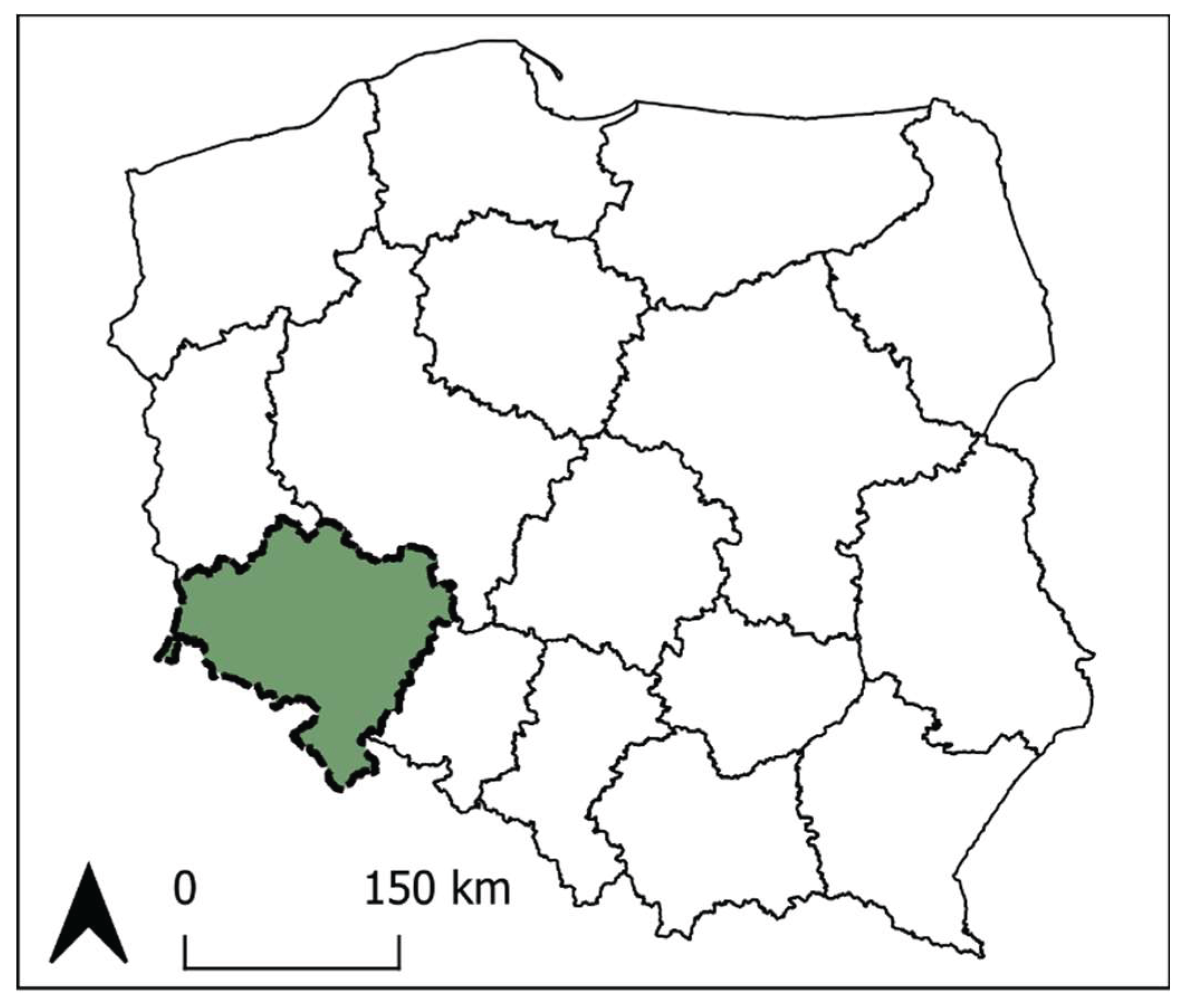
Figure 2.
(a) The physico-geographical macroregions of Lower Silesia; (b) Zones demarcated for research. Source: own elaboration.
Figure 2.
(a) The physico-geographical macroregions of Lower Silesia; (b) Zones demarcated for research. Source: own elaboration.
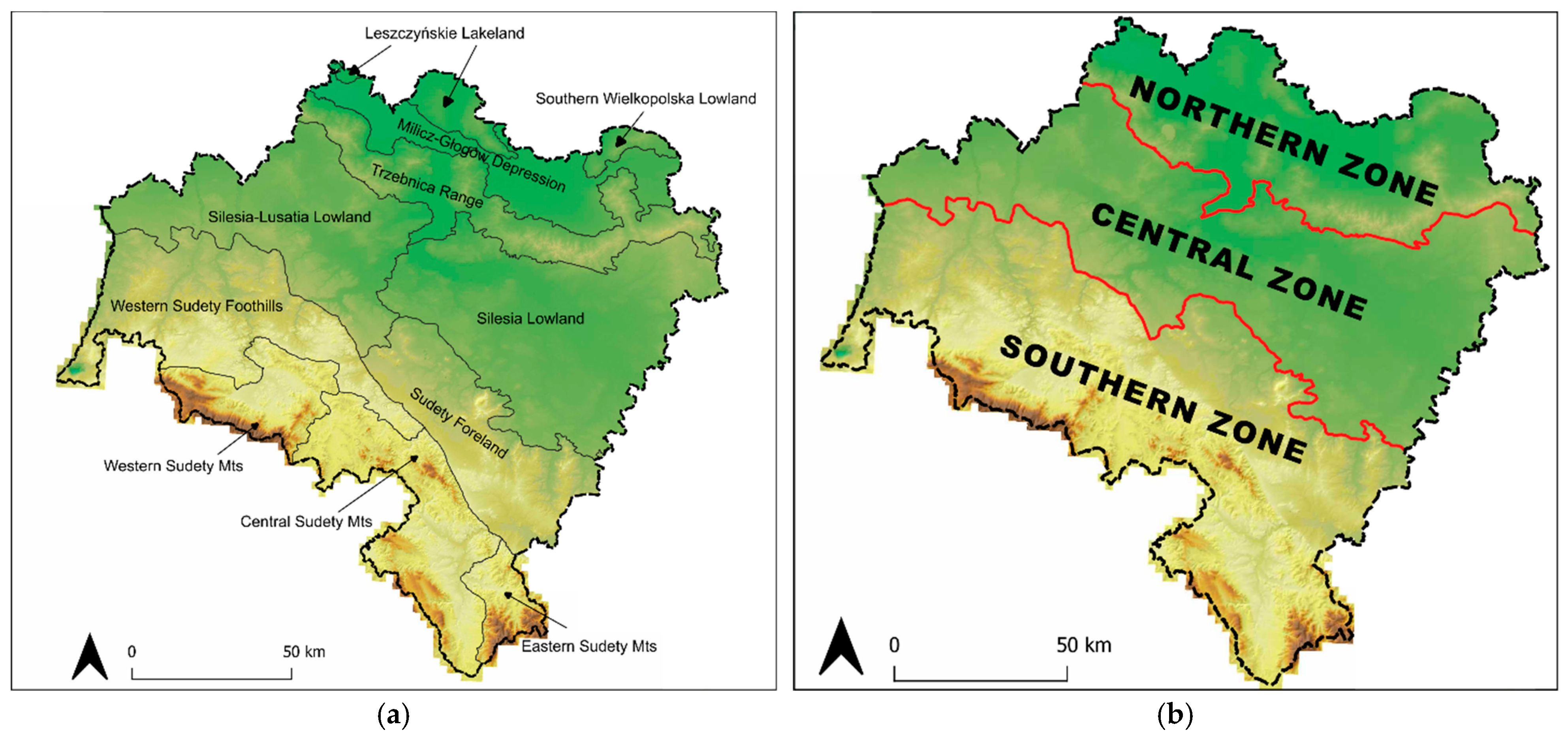
Figure 3.
Tourist attractiveness of poviats (based on the Tourist Attractiveness Index). Source: own elaboration based on: [31].
Figure 3.
Tourist attractiveness of poviats (based on the Tourist Attractiveness Index). Source: own elaboration based on: [31].
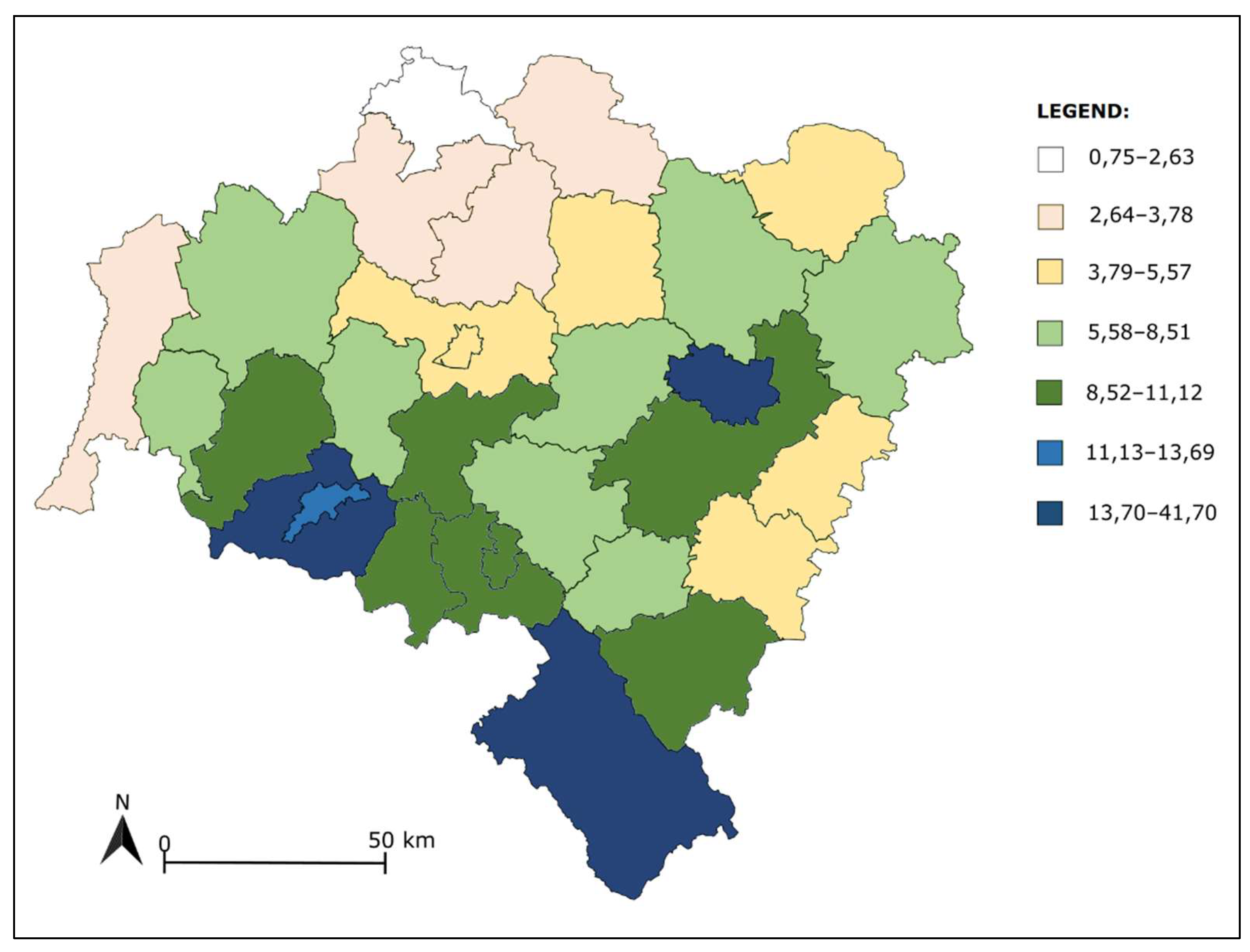
Figure 5.
Distribution of hillforts classified as potential tourism resources (objects without physical in-terpretation in situ; N=251). Source: own elaboration.
Figure 5.
Distribution of hillforts classified as potential tourism resources (objects without physical in-terpretation in situ; N=251). Source: own elaboration.
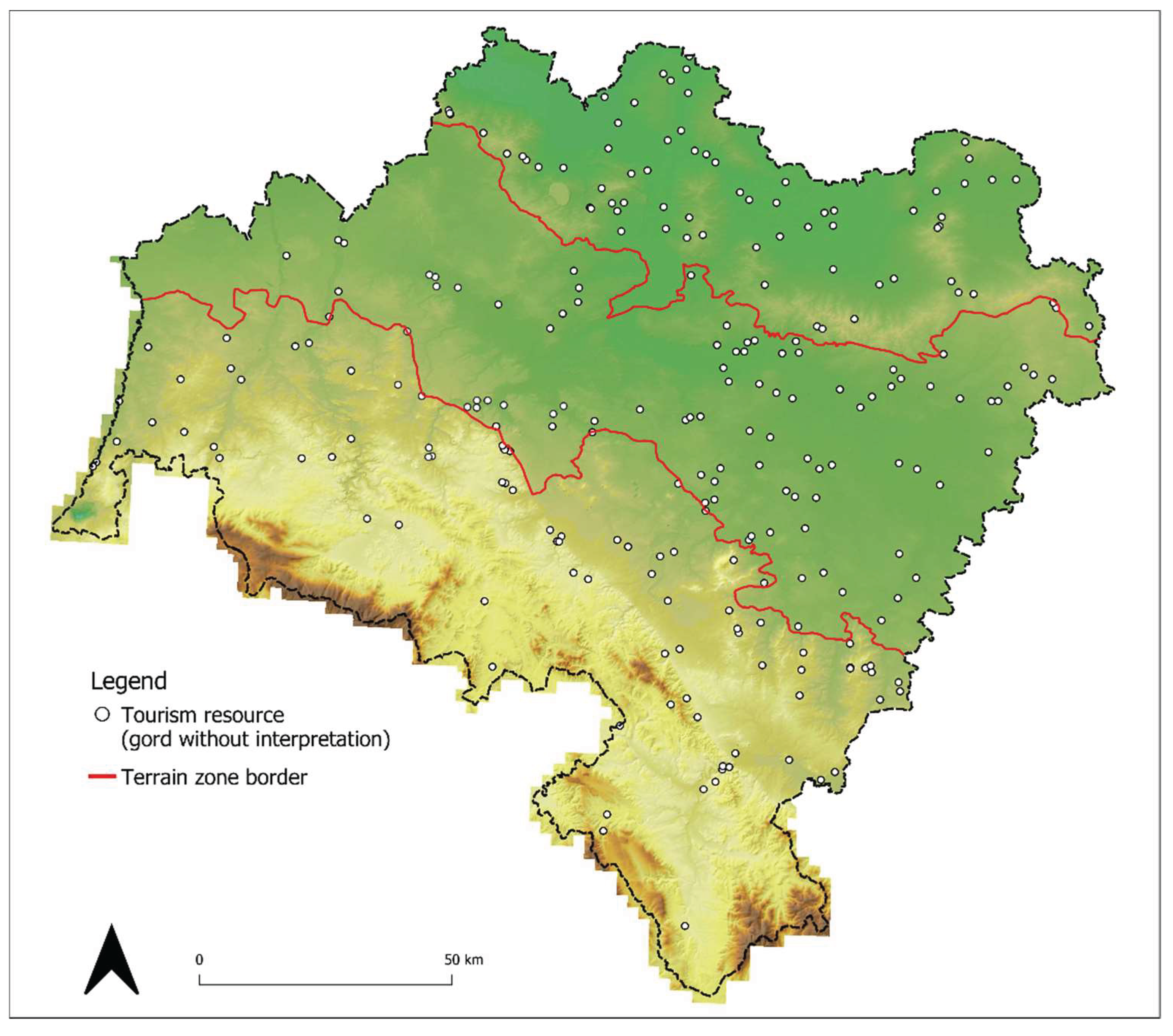
Figure 6.
Hillforts from each zone selected to research. Source: own elaboration.
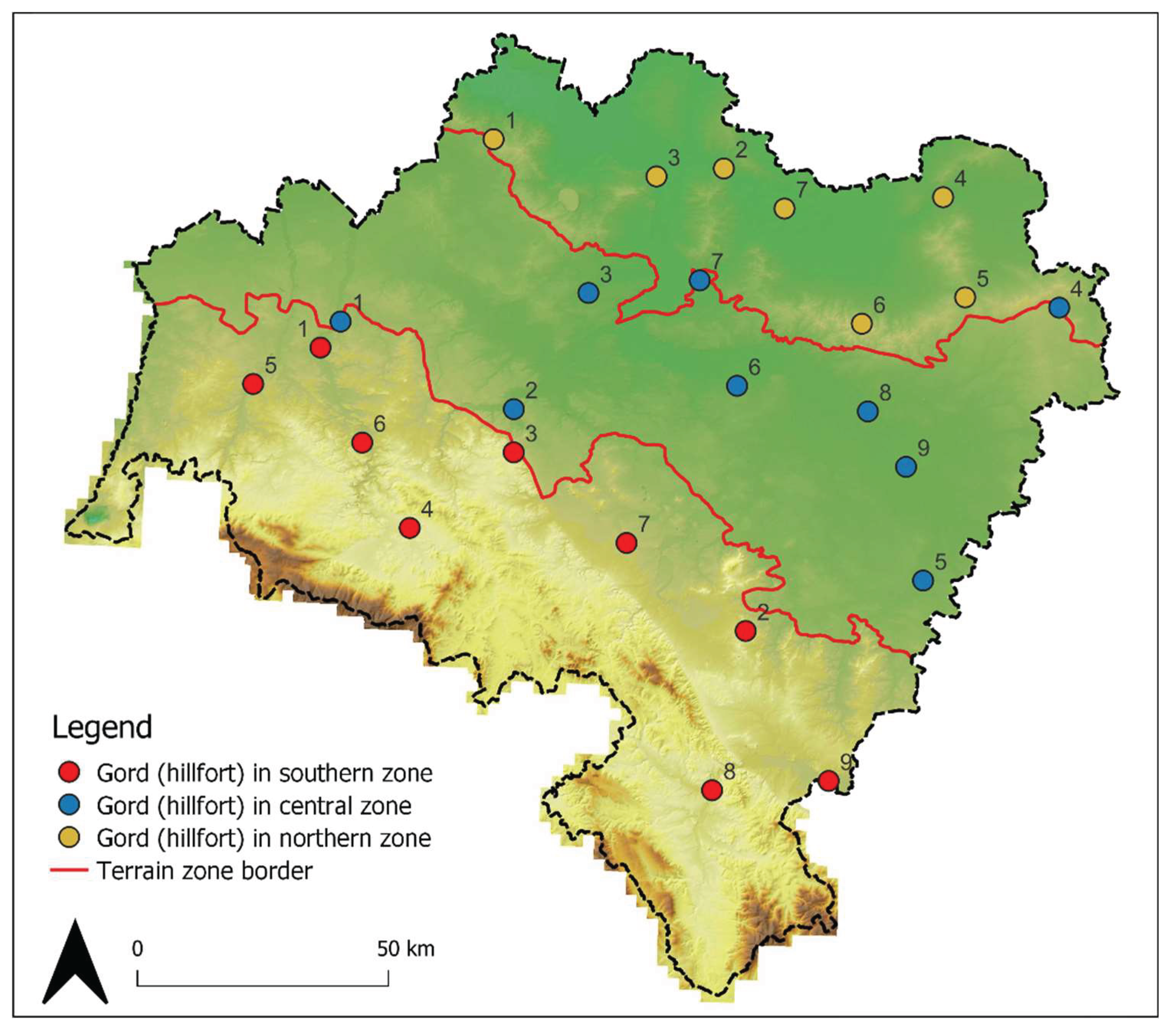
Figure 7.
Distribution of results of the tourism potential assessment of the selected hillforts. Source: own elaboration.
Figure 7.
Distribution of results of the tourism potential assessment of the selected hillforts. Source: own elaboration.
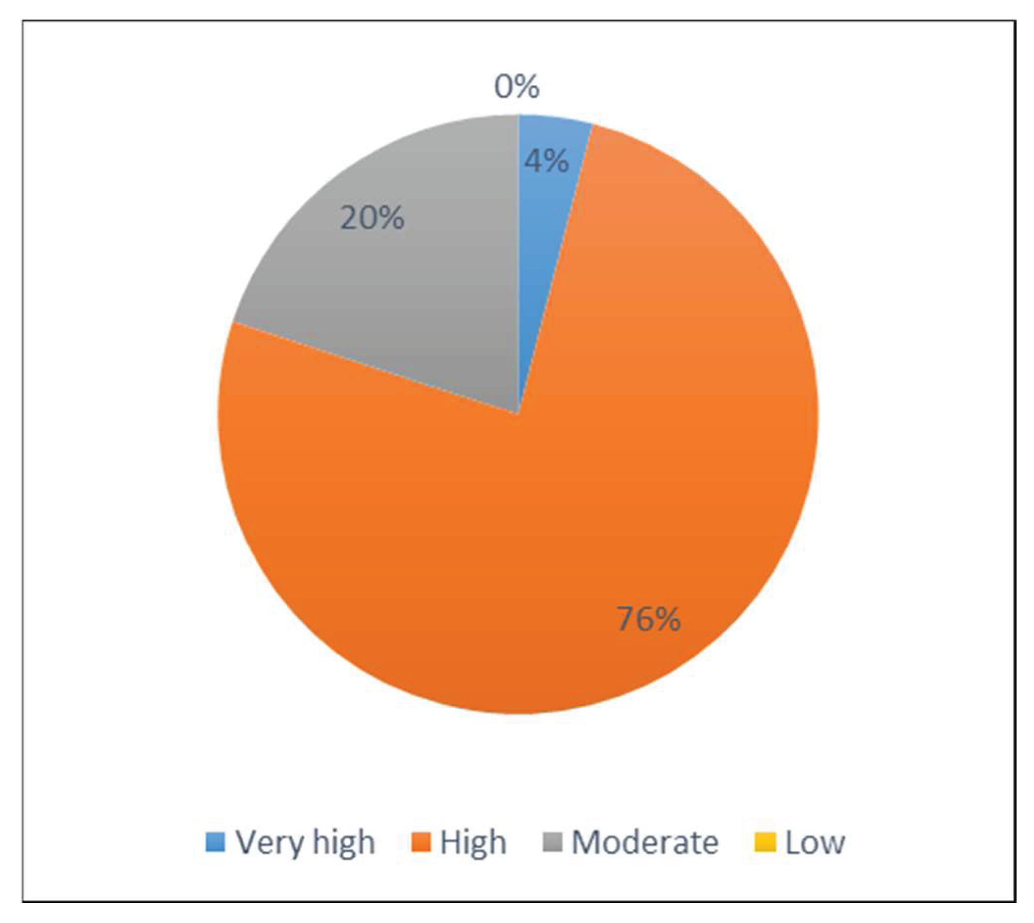
Figure 8.
Results of the tourism potential assessment of hillforts in three zones. Source: own elaboration.
Figure 8.
Results of the tourism potential assessment of hillforts in three zones. Source: own elaboration.
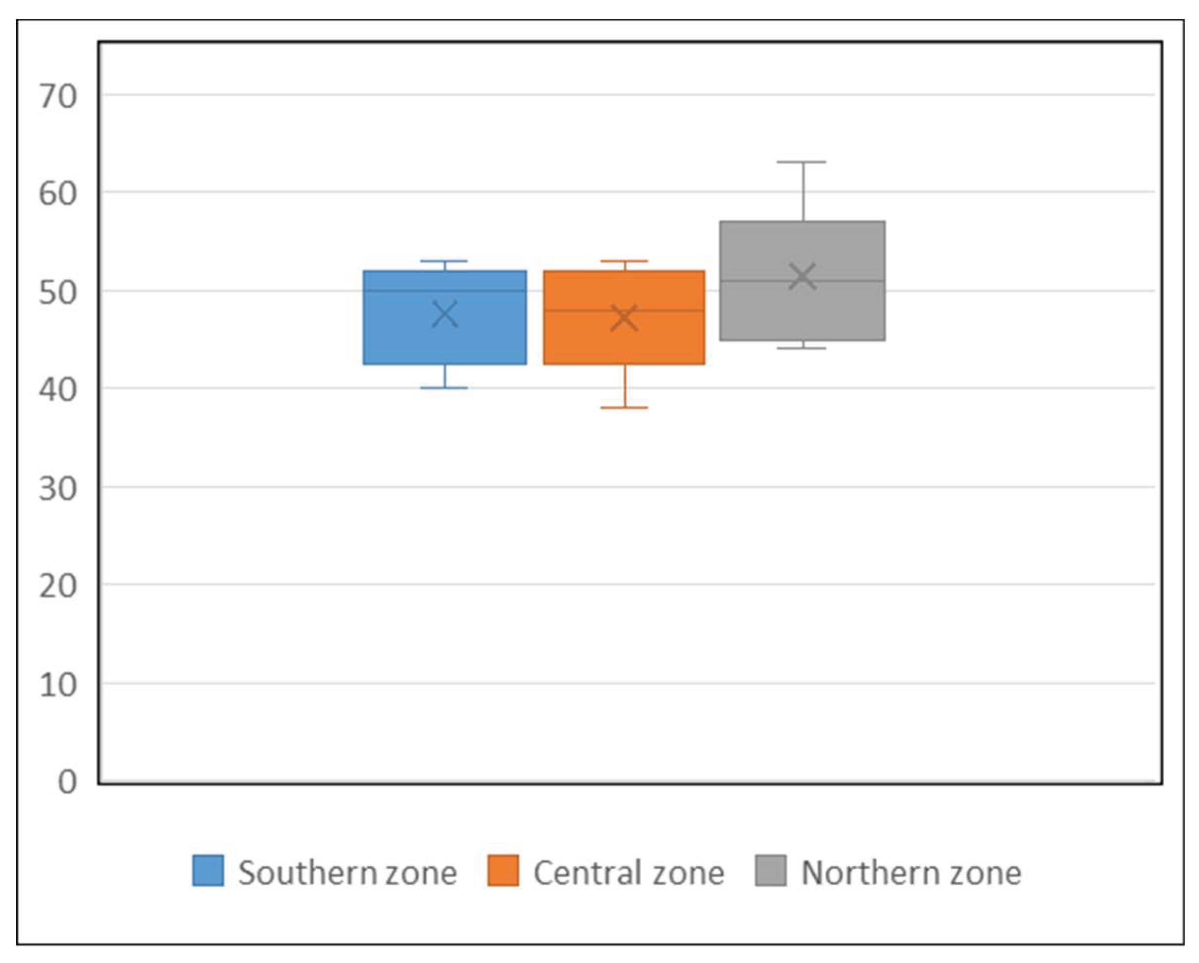
Figure 9.
Hillfort in Krajów, st. 2. (a) Part of eartch walls from NE side, with visible wet ditch. (b) Lidar map of the object, showing the scale of the strongholds. Source: own elaboration.
Figure 9.
Hillfort in Krajów, st. 2. (a) Part of eartch walls from NE side, with visible wet ditch. (b) Lidar map of the object, showing the scale of the strongholds. Source: own elaboration.
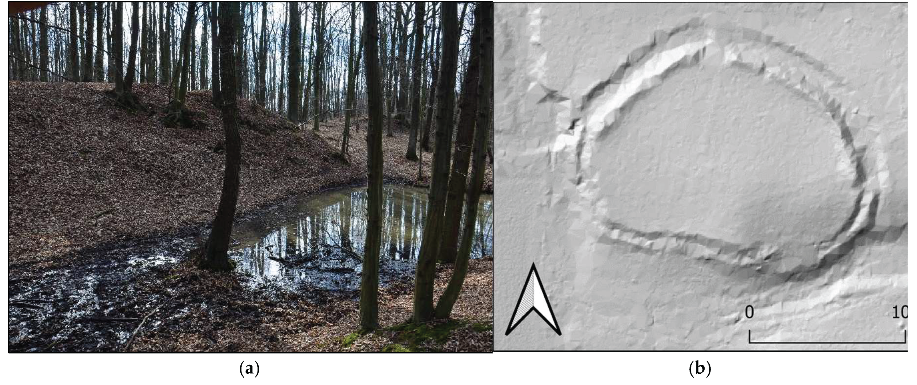
Figure 10.
Hillfort in Kadłub, st. 4. (a) Part of motte from E side, with visible wet ditch. (b) Lidar map of the object, showing the scale and complexity of the strongholds. Source: own elaboration.
Figure 10.
Hillfort in Kadłub, st. 4. (a) Part of motte from E side, with visible wet ditch. (b) Lidar map of the object, showing the scale and complexity of the strongholds. Source: own elaboration.
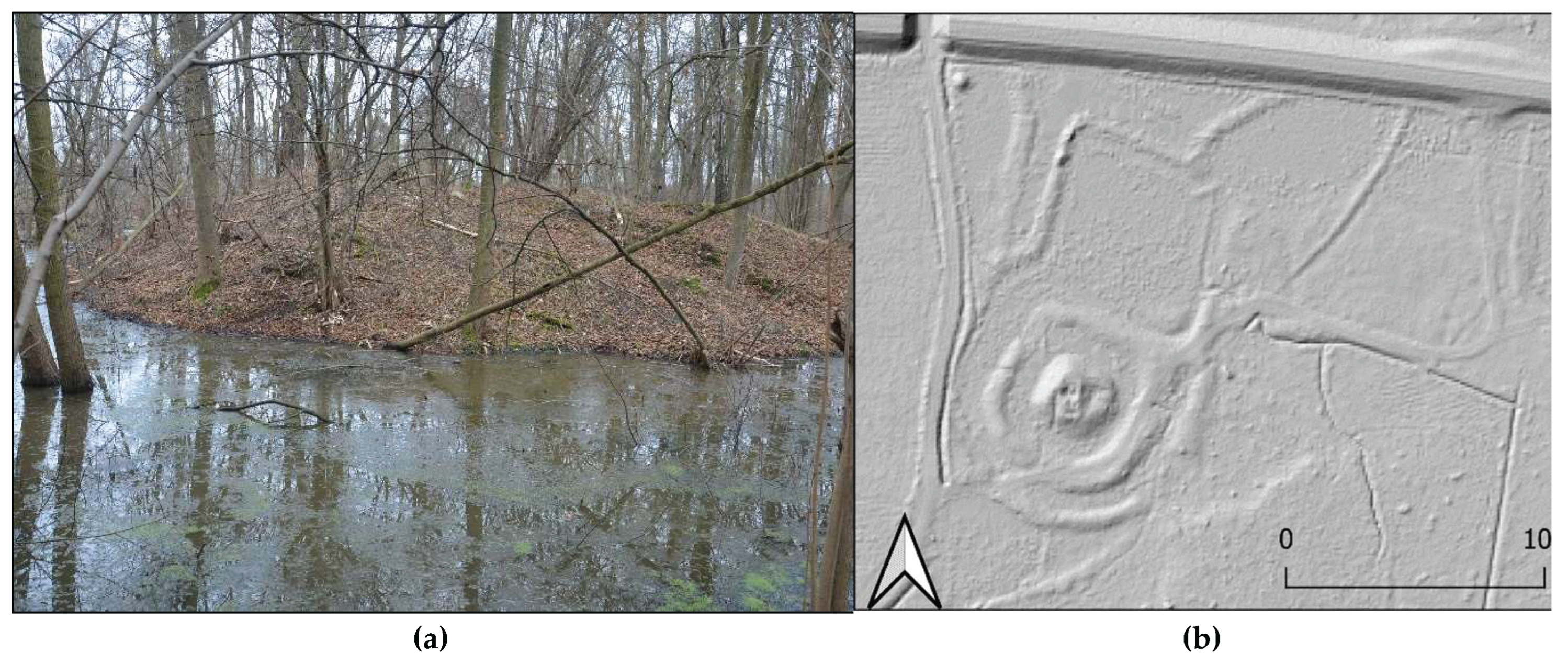
Figure 11.
(a) Hillfort in Bukowinka, st. 1 (b) Hillfort in Pomocne, st. 1 (Górzec). Source: own elaboration.
Figure 11.
(a) Hillfort in Bukowinka, st. 1 (b) Hillfort in Pomocne, st. 1 (Górzec). Source: own elaboration.
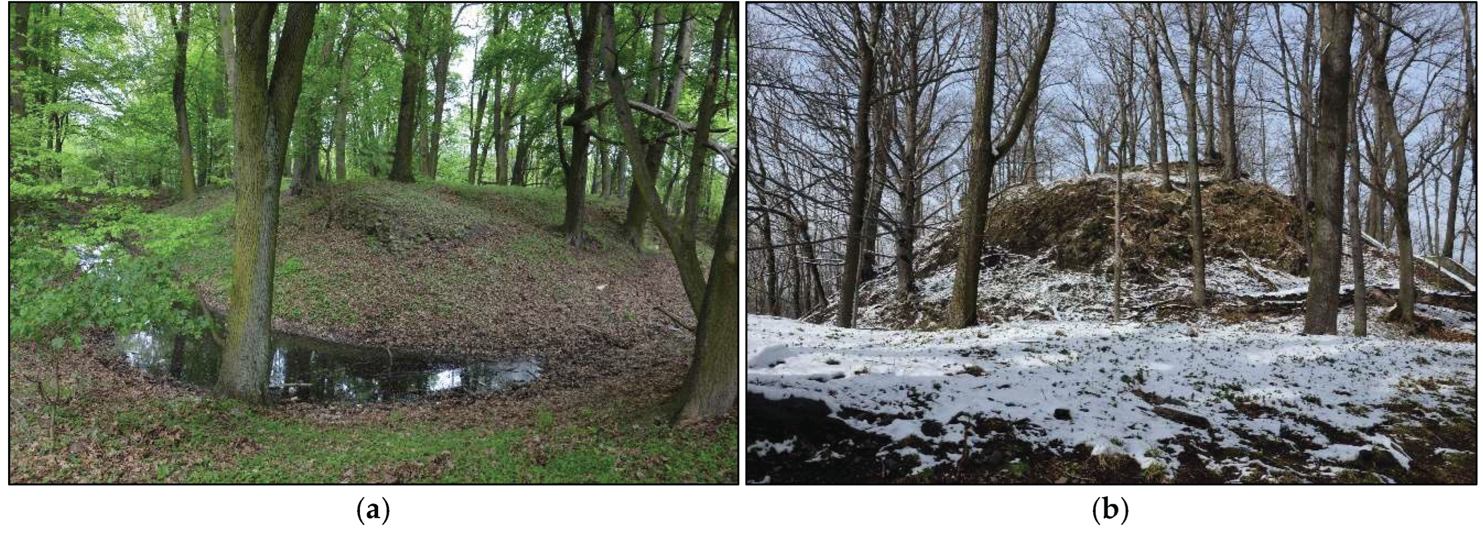
Figure 12.
Hillforts in urban areas. (a) Hillfort in Trzebnica, st. 3, in the town centre (b) Hillfort in Wrocław-Sołtysowice, st. 2, in the public park. Source: own elaboration.
Figure 12.
Hillforts in urban areas. (a) Hillfort in Trzebnica, st. 3, in the town centre (b) Hillfort in Wrocław-Sołtysowice, st. 2, in the public park. Source: own elaboration.
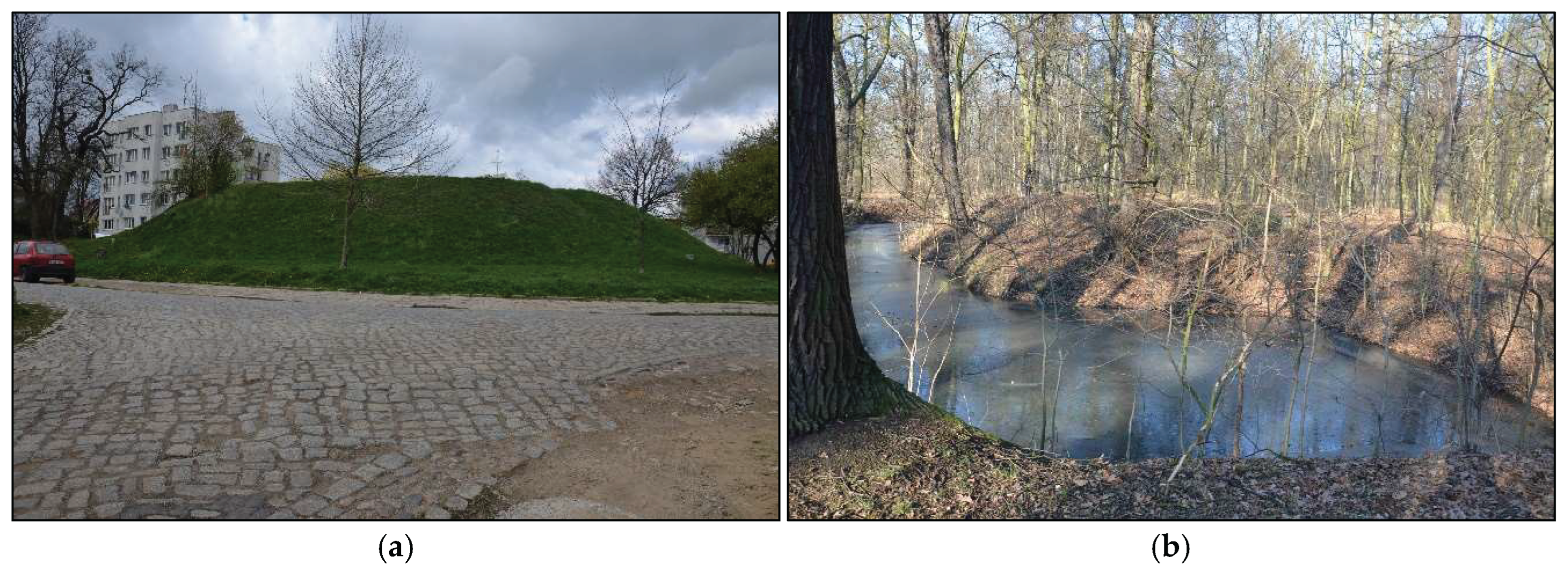
Figure 13.
(a) Lidar map of hillfort in Dankowice, st.1 (b) Hillfort in Nawojów Śląski, st. 1. Source: own elaboration.
Figure 13.
(a) Lidar map of hillfort in Dankowice, st.1 (b) Hillfort in Nawojów Śląski, st. 1. Source: own elaboration.
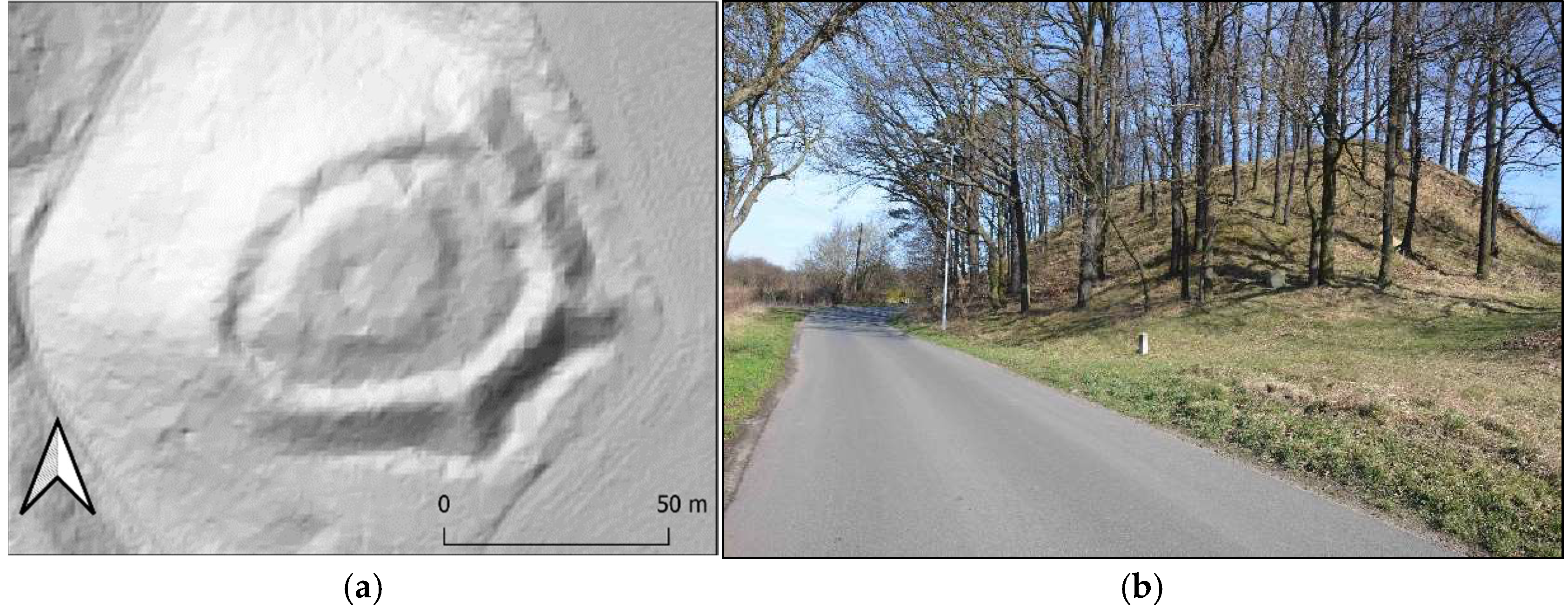

Table 1.
Criteria of assessment of hillforts. Source: own elaboration.
| Category | Criterion | Max score |
|---|---|---|
| 1. Physical characteristics | Site status | 4 |
| Chronology & archaeological cultures | 3 | |
| Research, documentation, literature | 6 | |
| State of preservation | 4 | |
| Site complexity | 3 | |
| Site size | 4 | |
| Site visibility | 3 | |
| Land cover | 3 | |
| Site prominence | 6 | |
| Viewpoint | 4 | |
| TOTAL | 40 | |
| 2. Surroundings and accessibility |
Land accessibility | 4 |
| Proximity to tourist trails | 5 | |
| Type of access (road, path) | 4 | |
| Distance to public transport | 2 | |
| Nearby archaeological sites | 3 | |
| Proximity to tourist attractions | 5 | |
| Parking availability | 2 | |
| TOTAL | 25 | |
| 3. Information visibility | Type of information source | 8 |
| Geocaching presence | 2 | |
| TOTAL | 10 |
Table 2.
Tourism potential tiers. Source: own elaboration.
| Tourism potential | % of total points | Score range |
|---|---|---|
| Very high | ≥80% | ≥60 |
|
High |
60–79% | 45–59 |
| Moderate | 40–59% | 30–44 |
| Low | <40% | <30 |
Table 3.
Hillforts selected to research – the number of object in each zone correspond with Figure 6. Source: own elaboration.
Table 3.
Hillforts selected to research – the number of object in each zone correspond with Figure 6. Source: own elaboration.
| Southern zone | ||
| No. | Hillfort name | Poviat |
| 1 | Otok, st. 2 | bolesławiecki |
| 2 | Roztocznik, st. 1 | dzierżoniowski |
| 3 | Pomocne, st. 1 (Górzec) | jaworski |
| 4 | Jelenia Góra - Grabary, st. 1 | m. Jelenia Góra |
| 5 | Nawojów Śląski, st. 1 (Łagów) | lubański |
| 6 | Marczów, st. 1 | lwówecki |
| 7 | Nowy Jaworów, st. 1 | świdnicki |
| 8 | Boguszyn, st. 1 | kłodzki |
| 9 | Chałupki, st. 1 | ząbkowicki |
| Central zone | ||
| No. | Hillfort name | Poviat |
| 1 | Bolesławiec, st. 1 | bolesławiecki |
| 2 | Krajów, st. 2 | legnicki |
| 3 | Niemstów, st. 6 (Zwierzyniec) | lubiński |
| 4 | Dziesławice, st. 1 | oleśnicki |
| 5 | Niemil, st. 1 | oławski |
| 6 | Kadłub, st. 4 | średzki |
| 7 | Wrzosy, st. 1 (Kretowice) | wołowski |
| 8 | Wrocław-Sołtysowice, st. 2 | m. Wrocław |
| 9 | Gajków, st. 10 | wrocławski |
| Northern zone | ||
| No. | Hillfort name | Poviat |
| 1 | Dankowice, st. 1 | głogowski |
| 2 | Bełcz Mały, st. 1 | górowski |
| 3 | Chobienia, st. 3 | lubiński |
| 4 | Milicz, st. 1 | milicki |
| 5 | Bukowinka, st. 1 | oleśnicki |
| 6 | Trzebnica, st. 3 | trzebnicki |
| 7 | Kędzie, st. 2 | trzebnicki |
Table 4.
Results of tourism potential assessment of selected hillforts, grouped in zones. Source: own elaboration.
Table 4.
Results of tourism potential assessment of selected hillforts, grouped in zones. Source: own elaboration.
| Southern zone | ||||||
| No. | Hillfort name | Cat. 1 | Cat. 2 | Cat. 3 | Total | Potential Level |
| 1 | Otok, st. 2 | 25 | 9 | 6 | 40 | Moderate |
| 2 | Roztocznik, st. 1 | 24 | 11 | 5 | 40 | Moderate |
| 3 | Pomocne, st. 1 (Górzec) | 24 | 19 | 7 | 50 | High |
| 4 | Jelenia Góra - Grabary, st. 1 | 25 | 14 | 7 | 46 | High |
| 5 | Nawojów Śląski, st. 1 (Łagów) | 28 | 15 | 8 | 51 | High |
| 6 | Marczów, st. 1 | 28 | 11 | 6 | 45 | High |
| 7 | Nowy Jaworów, st. 1 | 32 | 16 | 5 | 53 | High |
| 8 | Boguszyn, st. 1 | 28 | 19 | 6 | 53 | High |
| 9 | Chałupki, st. 1 | 24 | 19 | 8 | 51 | High |
| Central zone | ||||||
| No. | Hillfort name | Cat. 1 | Cat. 2 | Cat. 3 | Total | Potential Level |
| 1 | Bolesławiec, st. 1 | 28 | 15 | 5 | 48 | High |
| 2 | Krajów, st. 2 | 32 | 16 | 5 | 53 | High |
| 3 | Niemstów, st. 6 (Zwierzyniec) | 25 | 15 | 1 | 41 | Moderate |
| 4 | Dziesławice, st. 1 | 22 | 12 | 4 | 38 | Moderate |
| 5 | Niemil, st. 1 | 28 | 10 | 6 | 44 | Moderate |
| 6 | Kadłub, st. 4 | 30 | 17 | 6 | 53 | High |
| 7 | Wrzosy, st. 1 (Kretowice) | 31 | 12 | 7 | 50 | High |
| 8 | Wrocław-Sołtysowice, st. 2 | 28 | 15 | 8 | 51 | High |
| 9 | Gajków, st. 10 | 30 | 13 | 4 | 47 | High |
| Northern zone | ||||||
| No. | Hillfort name | Cat. 1 | Cat. 2 | Cat. 3 | Total | Potential Level |
| 1 | Dankowice, st. 1 | 28 | 14 | 3 | 45 | High |
| 2 | Bełcz Mały, st. 1 | 34 | 17 | 3 | 54 | High |
| 3 | Chobienia, st. 3 | 27 | 11 | 6 | 44 | High |
| 4 | Milicz, st. 1 | 32 | 18 | 7 | 57 | High |
| 5 | Bukowinka, st. 1 | 25 | 16 | 5 | 46 | High |
| 6 | Trzebnica, st. 3 | 30 | 25 | 8 | 63 | Very high |
| 7 | Kędzie, st. 2 | 28 | 18 | 5 | 51 | High |
Table 5.
The average results of tourism potential of hillforts for zones and total researched objects. Source: own elaboration.
Table 5.
The average results of tourism potential of hillforts for zones and total researched objects. Source: own elaboration.
| Southern Zone | AVG. | MDN. | SD |
| Category 1 | 26,44 | 26,5 | 2,59 |
| Category 2 | 14,78 | 14,5 | 3,61 |
| Category 3 | 6,44 | 6 | 1,07 |
| Total SZ | 47,25 | 48 | 4,85 |
| Central Zone | AVG. | MDN. | SD |
| Category 1 | 28,22 | 28 | 2,94 |
| Category 2 | 13,89 | 15 | 2,13 |
| Category 3 | 5,11 | 5 | 1,91 |
| Total CZ | 47,22 | 48 | 4,98 |
| Northern Zone | AVG. | MDN. | SD |
| Category 1 | 29,14 | 28 | 2,85 |
| Category 2 | 17 | 17 | 4 |
| Category 3 | 5,29 | 5 | 1,75 |
| Total NZ | 51,43 | 51 | 6,52 |
| TOTAL (N=25) | AVG. | MDN. | SD |
| Category 1 | 27,84 | 28 | 2,36 |
| Category 2 | 15,08 | 15 | 2,73 |
| Category 3 | 5,64 | 6 | 1,36 |
| TOTAL | 48,56 | 50 | 4,70 |
Disclaimer/Publisher’s Note: The statements, opinions and data contained in all publications are solely those of the individual author(s) and contributor(s) and not of MDPI and/or the editor(s). MDPI and/or the editor(s) disclaim responsibility for any injury to people or property resulting from any ideas, methods, instructions or products referred to in the content. |
© 2025 by the authors. Licensee MDPI, Basel, Switzerland. This article is an open access article distributed under the terms and conditions of the Creative Commons Attribution (CC BY) license (http://creativecommons.org/licenses/by/4.0/).
Copyright: This open access article is published under a Creative Commons CC BY 4.0 license, which permit the free download, distribution, and reuse, provided that the author and preprint are cited in any reuse.


