
Submitted:
07 May 2025
Posted:
08 May 2025
You are already at the latest version
Abstract
Impact cratering determined by collisions with meteorites and asteroids is considered one of the main natural processes in the Solar System, modifying the planets and their satellites surface during Time. The Earth includes in its impact record a small number of such events due to active plate tectonics, sedimentation and volcanism, these geological processes destroying and burying their impact geomorphological signatures. To enlarge the Earth’s impacts database new concepts and research methods are necessary, as well as re-interpretation of old geological and geophysical models. Geomorphological, Ge-ological and Geophysical (3G) signatures in concealed impacted areas are discussed in this paper, the first offering the target characteristics, while the other ones giving means for detecting their unseen remnants. The 3G signatures have been applied to the Tran-sylvanian Depression, a fascinating geological structure, with difficulties in explaining the direct overlapping of regionally developed thick tuff and thick salt layers, and un-decided interpretation of the regional magnetic anomaly. Large and deep sedimentary basins, such as the Precaspian, Alexandria and Transylvanian depressions, are inter-preted to have started as impacted areas during the Permian or the Lower Neogene. Geophysical and geological existing information have been reinterpreted, offering a new way in understanding deeply located geological structures.
Keywords:
impacted structures
; geomorphological
; geological
; geophysical signatures
; Transylvanian impacted structure
; large impacted sedimentary basins
1. Introduction
All along mankind history people were looking to the Moon during night time, trying to understand the rounded dark scars on its shining “face”. Quite recently, meaning a few centuries ago, scientists believed that these dark spots are “seas”, and baptized them with sea names.
Since geologists discovered rounded craters on continents which could not be clearly related to volcanic processes, the association of these terrestrial scars with the Moon “seas” and the wondering cosmic bodies, such as meteorites and asteroids, was done by specialists in Astronomy and Earth Sciences.
Once Geology accepted modifications from the “stable” evolutive philosophy, of only gradual changes during geological processes, numerous scientific studies, many times aided by borehole information or geophysical surveys, re-interpreted geological structures as being due to impact with extraterrestrial bodies. Unexpectedly, but in fact very useful, such impacted geological structures started to be included in geological and geophysical exploration projects for hydrocarbon accumulations, due to the good reservoir quality of the impacted rocks [1].
Besides filling gaps in the planetary record, where large impacts are sometimes associated with significant life extinctions on Earth (e.g., [2]), the use of Geophysics is crucial for revealing concealed remnants of impacted large and deep sedimentary basins.
The study dedicated to the geophysical detection and to geological models reinterpretation of large sedimentary basins, meaning the Precaspian Depression, located in Russia and Kazakhstan [1] and the Alexandria Depression, located in Romania and Bulgaria [3], is continued within this work with the Transylvanian Depression, located in Romania, as an impacted structure during the Badenian (Lower Miocene).
2. Geomorphological, Geological and Geophysical Signatures of Large Impacted Areas
2.1. Geomorphological Signatures of Large Impacted Areas
Geomorphological features of impacted areas on Earth by small cosmic bodies, as nicely shown nowadays by the well preserved Meteorite Crater (Arizona, U.S.A.), are represented by a circular depression created during the impact, limited at its outer diameter by an uplifted zone.
It was established by impact cratering scientists (e.g., [4]) that beyond the value of 4 km crater diameter its morphology becomes more complicated:
- 1)
- Crater Rim, encircling the impacted area, built with uplifted geological formations and ejecta products provided by the crater excavation during impact;
- 2)
- Central Peak, created in the area where the cosmic body hit the ground or sea bottom, determining a sudden downlift of the geological formations, followed by their subsequent uplift due to a rebound process;
- 3)
- Crater, a depressionary area surrounding the Central Peak, floored by fractured geological formations of its basement and partially covered by melted rocks. Large quantities of debris, determined by the initial impact explosion, falling as rock avalanches from the uplifted Crater Rim and Central Peak, are filling the Crater area.
Unfortunately for crater impacts scientists, most geomorphological traces of past impacts occurred on Earth during geological time have been erased by erosion processes, or hidden by seawater, sedimentation or volcanic processes.
2.2. Geological Signatures of Large Impacted Areas
As described by field geological observations or when studying borehole cores, there is a specific succession of geological formations sedimentation, suite of an impact with a cosmic body:
- post-impact breccias and coarse conglomerates;
- conglomeratic sandstones and sandstones, displaying significant thickness variations;
- fine-grained sandstones, siltstones and shales are deposited when the pre-impact depositional conditions have been reestablished.
The post-impact breccias covering the crater floor are mainly deposited by rock avalanches coming either from the Crater Rim or the Central Peak [5].
As showed by borehole information, chaotic stratigraphy, shocked quartz, uplifted or repeated strata and polymictic breccias may occur at the crater Central Peak [6].
The impacted sedimentary structures may have two important structural components [7]:
- 1)
- Depression, where the impacted area reaches its maximum depth, as a consequence of direct hit by the cosmic body;
- 2)
- Basin, also called the Annular Trough, a larger area including the Depression. The deformations are largely confined to the sediments layer, where concentric collapsed structures and a peripheral ring graben are major extensional structures.
Large impacts have produced in many cases subsurface hydrothermal systems within the Depression deep geological structures [2].
Large impacts craters that we recently studied, such as the Alexandria Depression, are closely associated with magmatic intrusive and effusive products. We interpreted these magmatic processes as being determined by the impact of asteroids with the Earth surface, followed by deeply located magma generation, eruptions and intrusion of igneous bodies. The case of the Precaspian Depression, that we also studied, is not relevant in this respect, the sedimentary fill thicker than 20 km not allowing geological observations or geophysical detection of probably too deep located magmatic products.
The most important geological signature of large impacts on Earth is the thick layer of salt, associated with anhydrite and gypsum, which is flooring the Crater and its neighboring area. In the Precaspian Depression this salt layer is 4 km thick, while in the Alexandria Depression the mean thicknesses of the salt layer is of a few hundreds of meters.
The first 2 km of salt layer in the Precaspian Depression, and significant basal parts of the Alexandria Depression salt layer, consist of white coarse salt, which is not sustaining the “lagoon salt deposition” model.
In our model, the necessary heat for marine water evaporation is not given by the Sun, being continuously provided by the hot impacted rocks from beneath the seawater, that may keep temperatures higher than 100o C up to several My.
2.3. Geophysical Signatures of Large Impacted Areas
Geophysical anomalies obtained in some areas as results of surveys usually conducted for finding deeply located minerals or oil and gas accumulations, started to be interpreted nowadays as representing traces of impacts with cosmic bodies. It proved so far to be the single possibility for discovering remnants of old impact craters, which are presently covered by thick geological sedimentary and volcanic formations, or by the seawater.
Gravity anomalies are probably the best geophysical information to locate the Crater area by means of a circular low Bouguer gravity anomaly, determined by lower density sedimentary formations which are filling the depression created by the impact with a meteorite or an asteroid. This circular or ellipsoidal low gravity anomaly may be sometimes limited by a rounded high gravity anomaly caused by higher density geological formations included within the Crater Rim, where it wasn’t destroyed by past erosion processes. In case of a large complex Crater, a central high gravity anomaly may indicate the in-depth location of the Crater Peak.
Bouguer gravity data may be subject of 3D modeling when studying concealed craters beneath seawater, as in the case of the Avak (Alaska, USA) impacted structure [6].
The Chesapeake Bay 40 km diameter crater was found to be characterized by a dome-shaped gravity low that reveals the central crater; it surrounds a gravity high that corresponds to the central uplift [7].
A good example where gravity anomalies revealed a buried impact crater beneath several kilometers of sedimentary formations, showing its Crater Rim and Central Peak by means of high gravity anomalies, has been recently interpreted in the Precaspian Depression [8], in [1].
When the Crater Rim and the Central Peak of a buried impact crater have been demolished by erosion processes, a rounded low gravity anomaly may still locate the depression created by the impact with a cosmic body, as in the case of the Alexandria Depression (Romania) [3]. The decision in such a case, whether the structure represents an impact crater or not, may be taken by the integrated interpretation of all relevant geophysical and geological information.
Geoid undulations, or geoidal anomalies, computed nowadays from terrestrial and satellite gravity observations, might be useful in case of very large impacted areas on Earth.
Such kind of both geodetic and geophysical data, processed and plotted under the form of a residual continental gravimetric geoid map [9], have been employed to localize and characterize the position and shape of the Precaspian Depression. The circular low anomaly has been interpreted to be due to the 20 km pile of sediments, including 4 km of salt layers, both of them less dense as compared to the crystalline basement and Palaeozoic sediments [1].
Magnetic anomalies may be also used to locate deeply situated impact craters, but in fewer cases as compared to the gravity ones and involving more interpretation difficulties.
When the impacted structure is made of thick sedimentary formations, devoid of significant magnetic properties, there are not sufficient magnetic contrasts between the geological background and the important crater features, such as the Rim or the Peak. In such cases the magnetic anomalies cannot be employed in detecting buried impact structures.
When the crystalline basement, generally characterized by higher magnetic properties as compared to the sedimentary ones, was involved in uplifted structures, such as the Crater Rim, circular high magnetic anomalies [10] may be interpreted as showing its buried location, as in the Precaspian Depression [1].
In cases where between the impacted structure and the topographic relief surface thick lava flows of intermediate or basic composition are intercalated, the magnetic anomalies will represent mostly the signal from the eruptive rocks and less from beneath, where the target is situated. Such a situation was recently found in the Alexandria Depression [3].
When large impacted areas are studied, satellite magnetic observations may be also useful. In the case of the Precaspian Depression, a lineament of intense low magnetic anomalies, recorded during the MagSat mission [11], have been interpreted as an asteroid multi-impact during the Lower Permian [1], creating very deep depressions where sediments are thicker than 20 km [12,13].
Reflection Seismic may rarely locate an unknown concealed impact crater, but they are able to provide accurate depth information till an already detected impacted structure, the architecture of the sedimentary formations situated above and inside the impact crater and possibly, their geological age.
A nice example in this respect is the reflection seismic section recorded in Kazakhstan on the concealed Precaspian Depression Crater Rim, where highly tectonized sedimentary formations occur only at several km deep, the post-impact layers looking tectonically undisturbed [14].
As an unexpected trend, already discovered impacted structures are nowadays surveyed with reflection seismic, aiming to locate structural geological traps where oil accumulations might be found. It was already noticed that the impacted geological formations are highly fissured and fractured, creating this way characteristics for a good reservoir.
Refraction seismic carried out mainly during the second half of the XXth century for discovering deep geological structures is presently utilized in updated interpretations of buried impacted structures.
There are situations, as in the Precaspian Depression, where the 20 km thick pile of sedimentary formations includes a 4 km salt layer that prohibits the effective utilization of reflection seismic at great depths. Refraction seismic provided in such situation structural information on the whole geological structure, the seismic velocity values computed at various depths being interpreted in terms of geological lithology beyond the boreholes penetration depth [15].
Seismicity determined by earthquakes occurred at various depth may be useful in case the impacted area did not reach yet the tectonic equilibrium, active faults located along the Crater Rim still producing seismic events. Maps with seismic epicenters may be used in such favorable tectonic circumstances to contour the impacted area even it happened a long time ago.
A good example is represented by the circular location of seismic epicenters in the Alexandria Depression (Romania), the Moesian Platform being characterized in that region by low seismicity, enhancing this way the possibility of locating the Depression boundary created by an asteroid impact during the Upper Permian time [3].
Heat flow anomalies might be observed above relatively recent impacted areas due to the residual high temperatures preserved by geological formations. Numerical simulations of large impacts showed that several million years the heat might be kept by rocks and geological formations after impact [2] and deep geothermal systems with hot groundwater are still to be found.
3. The Transylvanian Depression
3.1. Location and Geomorphological Features
The Transylvanian Depression is situated in the central and northwestern parts of Romania, being surrounded by the East Carpathians, the South Carpathians and the Apuseni Mountains (Figure 1).
The name “depression” may be here a source of confusion, since it is both a lowered region between mountains, when considering its geomorphological characteristics, and an area where sedimentary deposits of various ages reach ca 9 km depth, when discussing about its concealed geological structure.
The topographic relief is decreasing from ca 600 m in NW, to 500 - 600 m within the rather flat central Transylvanian Plain, and increasing toward SE, with altitudes generally ranging between 600 and 800 m, with a regional uplift due to active tectonics.
The rivers network is dominated by the ENE-WSW trend across the Transylvanian Depression, from the East Carpathians toward the narrow Mures Valley, when it starts flowing between the Apuseni Mts and South Carpathians: Mures, Tarnava Mica and Tarnava Mare rivers. Somes and Olt rivers, situated at the northern and southern depression margins, respect the above mentioned trend while flowing between the depression limits, but change abruptly direction northwestward (Somes), flowing into the Tisa river in Hungary, avoiding this way the Apuseni Mts, or southward (Olt), crossing the South Carpathians toward the Danube river.
3.2. Geological Setting
Transylvanian Depression is considered as the largest post-tectonic Neogene molasse depression situated on the Romanian territory (Figure 2). What are geologically considered as Transylvanian Depression are the folded parts of Dacides, including the Transylvanides and their post-tectonic sedimentary cover up to the Lower Miocene. The depression started to be built at the end of the Lower Miocene, the entire area being characterized by deposition of the Dej Tuff and the Salt Formation of Badenian age. Active subsidence continued during the Sarmatian and the Pannonian [17].
Studying the rocks and geological formations pierced by hundreds of exploration boreholes aiming at locating methane gas accumulations, the authors of a book dedicated to the Transylvanian Depression [19] offered a rich database, valued and utilized in this work:
- 1)
- The crystalline basement, penetrated by deep boreholes in the depression central area, consists of sericite and chlorite schists, quartzites and micashists. The northwestern part where the basement is outcropping or situated at shallow depth is characterized by higher metamorphism (paragnaises, micashists, quartzite shists with garnet).
- 2)
- The pre-depression sedimentation cycles that have been established, Permian-Triassic and Jurassic-Cretaceous, have no real significance for our study and will be not discussed.
- 3)
- The Transylvanian Depression was considered to include five sedimentation cycles: Upper Cretaceous, Paleogene, Burdigalian-Helvetian, Tortonian-Buglovian-Sarmatian and Pliocene. Since all major geological events discussed in this paper happened during the Tortonian (presently equivalent to the Badenian), our study is concentrated on this geological time interval (ca 15 My BP).
The Badenian represents the beginning of a marine transgression, the thick Dej Tuff overlapping different older sedimentary formations and the crystalline basement.
The geological succession of Badenian sedimentary and evaporitic deposits is similar to those coeval, mapped in the East Carpathians: the basal tuff layer, the salt layer, shists with radiolarium and marls with Spirialis.
The Dej Tuff overlaps on large areas, especially at the northern and southern depression margins, thick conglomerate layers, in places replaced by sandstones. The largely developed conglomeratic basal layer was no longer found in boreholes located towards the depression center. However, above the central depression basement uplift a borehole revealed the presence of a 30 m thick conglomerate layer.
The Dej Tuff, having as equivalent the Persani Tuff, was found to have thickness ranging from several meters to hundreds of meters. It was considered as a dacitic or riolitic magmatic product [20], resulted from extrusive volcanic activities in, or around the Transylvanian Depression. Close to the northern depression margin the Dej Tuff thickness is increasing from 20 to 200 m. At the southeastern depression margin the Persani Tuff have thickness between 250 and 550 m. Within the Depression the Dej Tuff layer has been continuously found in boreholes, beneath the salt layer, with thickness ranging between 5 and 80 m.
The Transylvanian Depression Badenian salt layer is outcropping at the depression northern and southern margins, while at the eastern and western margins it is forming salt diapirs up to 1,800 m thick. At the depression inner parts the salt layer has been found with variable thickness by all boreholes, most thickness values being higher than 200 m.
The Badenian sediments overlapping the salt layer are mostly marly within the depression northwestern sector; the sand intercalations are increasing in thickness from W to E and from N to S.
3.3. Geophysical Setting
Gravity anomalies
The Bouguer map of Romania has been completed in 1992 [21] and a derived gravity map, contoured on mean gravity values had to be built in order to be incorporated in the Bouguer gravity map of Europe [22]. This already filtered gravity dataset for low intensity local anomalies proved to be a suitable input in geophysical regional and crustal studies.
The Bouguer gravity anomalies, derived from mean data evaluated in a 5’ x 7.5’ grid are presented in Figure 3. The high gravity anomaly, colored in orange and yellow, trending N-S in the depression central and northern parts and changing direction toward NE-SW in its southern sector, is determined by the uplift of high density crystalline basement and superjacent Mesozoic sediments.
The low gravity anomalies, colored in green, are mainly depicted as NNE-SSW and N-S elongated sectors at the western and eastern depression limits, and a rather circular anomaly in the depression southern part. These anomalies are determined by the lower density thickened sedimentary formations around the central basement rise, with important contributions of low density from the salt diapirs situated at the depression western and eastern limits.
Magnetic anomalies
The magnetic anomalies, either terrestrial or airborne, revealed in the Transylvanian Depression a regional high intensity anomaly, trending N-S in its northern sector and enlarged toward a circular shape in the depression southern part (Figure 4).
There is not yet a consistent and accepted interpretation for this large and intense magnetic anomaly situated in the middle of a geological depression, a fact unknown to most geologists.
A geophysical model, proposed by [24], interpreted a crustal body having the characteristics of a magmatic batholith, situated within the upper crust, as the magnetic anomaly source.
A geological model, published by [25] interpreted ophiolitic rocks largely developed in-depth as an obducted oceanic suture, as the geological source of the magnetic anomaly.
Reflection and Refraction seismic surveys
Benefiting of good quality reflection limits in the Transylvanian Depression, such as the regionally developed Badenian and Buglovian tuff layers, important structural features of the sedimentary formations have been revealed to exploration geologists by reflection seismic surveys since the early ’50s.
To get structural information on the pre-Neogene sedimentary formations and the crystalline basement-sedimentary cover boundary, refraction seismic started to be employed a decade later. Two main refraction limits have been interpreted at the depression scale: top Mesozoic formations and basement-sedimentary cover. The central depression uplift involving the crystalline basement and the surrounding depressionary areas have been illustrated this way, the Sighisoara depression reaching 9 km depth [19].
A subsequent stage of refraction seismic studies developed during the early ’70 when a seismic line crossed NW-SE the depression northern part aiming at revealing the deep crustal structure. As particular newly discovered features, a thin upper crust and an in-depth velocity anomaly have been interpreted in the central depression area [26].
Geothermal studies
Suite of geothermal researches, carried out in boreholes and as field surveys during the ’60s and the ’70s, the Transylvanian Depression has been characterized as a low heat flow region [27].
The lowest values of the geothermal gradient, 3o C/100 m, have been measured in the central part of the depression, due to the presence of thick sedimentary deposits. The geothermal gradient increases to 5o C/100 m toward the depression margins, due to reduced thickness of sediments [28].
3.4. The Transylvanian Depression as an Impacted Area
The idea that the Transylvanian Depression might be an impacted geological structure came some 20 years ago, when models of impact craters have been largely discussed and published. The geological section across the Transylvanian Depression [19] and the regional distribution of salt bodies, in and around the depression [29], are at the origin of the impact model presented in this paper.
Since we already discussed the geomorphological, geological and geophysical signatures of an impacted area, they will be briefly applied for the Transylvanian Depression.
Geomorphological signatures
The regional geomorphological features of the Transylvanian Depression do not suggest an impacted structure. The depression surface is quite flat in its central parts, the topographic heights increasing southeastward, where the youngest sediments of Pliocene age outcrop.
Geological signatures
As mentioned above, the NNW-SSE geological section [19] crossing on ca 250 km the Transylvanian Depression may represent a significant geological signature for an impacted structure. The geological section, built based on borehole and refraction seismic data, has been simplified and presented in Figure 5, illustrating the main geological boundaries beneath the Transylvanian Depression: the crystalline basement - sedimentary cover and the Badenian transgression unconformity, started with the Dej Tuff.
As it may be observed in Figure 5, the boundary between the crystalline basement-sedimentary cover reproduces the complexe impact crater model, with uplifted metamorphic formations at the structure margins (Crater Rim) and in its central zone (Central Peak). The Central Peak was faulted, its SSE half being downlifted with ca 2.5 km, together with the whole southeastern depressionary area. Upper Badenian, Sarmatian and Pliocene sediments increased in thickness after the impact due to the basement rupture and increased subsidence, in close connection with post subduction collision in the Vrancea zone [30,31].
The basal layer of the Badenian transgression is represented by conglomerates developed on large areas. As discussed above, thick and widespread conglomerates might be a significant geological signature, this geological formation consisting mostly on debris of rocks crushed by the impact explosion. The conglomerates in the depression southern part have thickness ranging between 100 and 500 m. They have a reddish matrix and crystalline clasts as blocks 5-12 km apart from the South Carpathians. At the northern depression margin the conglomerates are thinner, up to 15 m, including magmatic and metamorphic clasts up to 0.75 m. In the borehole located on the central basement uplift the conglomerates reach 30 m thickness. In the internal part of the depression the conglomerates are missing, being replaced by grey or reddish marls and clays.
The widespread Dej Tuff, as a continuous layer with thickness ranging between 20 and 550 m toward the depression margins, indicates the onset of regional volcanic processes, possibly suite of the impact with the cosmic body, most probably an asteroid. There are geological hypotheses related to the volcanoes location, either within the Transylvanian Depression, or in its close vicinity [20].
The salt layer has been pierced by all deep boreholes within the depression, its mean thickness value being 400 m [19]. The regional concealed salt layer is an important signature in all studied impacted areas, salt being deposited in a hot marine environment having at the sea bottom impacted rocks that preserve a long time residual heat.
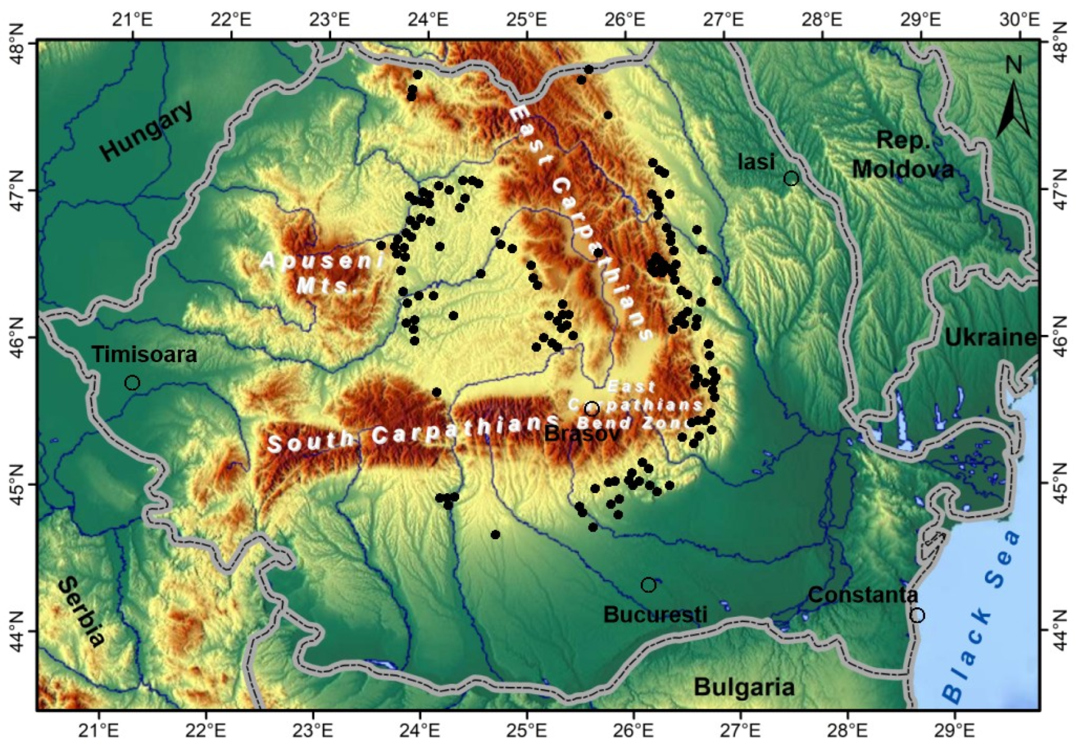
Figure 6.
Regional occurrence of salt bodies in and around the Transylvanian Depression. Regional topographic map: H. Braxmeier (2017) https://maps-for-free.com/ accessed 2021 [16]. Black dots: salt bodies (modified after [29].
Figure 6.
Regional occurrence of salt bodies in and around the Transylvanian Depression. Regional topographic map: H. Braxmeier (2017) https://maps-for-free.com/ accessed 2021 [16]. Black dots: salt bodies (modified after [29].
The succession of Badenian deposits is similar to those mapped in the Subcarpathians geological units (outer East Carpathians): basal tuff (Dej Tuff or Persani Tuff), salt layer, shists with radiolarium and marls with Spirialis [19].
Two anhydrite layers of Badenian age, reaching 40 m in thickness, are included in the East European Platform sedimentary cover, at its westernmost limit situated beneath the East Carpathians sedimentary nappes, NE Romania.
Geophysical signatures
A. Gravity anomalies
The main geophysical signature that comes from the impacted area is the high gravity anomaly illustrated in the Bouguer gravity map (Figure 3). This anomaly is mainly associated with the uplifted crystalline basement interpreted here as a Crater Peak, suite of the impact and subsequent crustal rebound. The high gravity anomalies, contoured at the northwestern and southeastern depression margins may be related to the crystalline basement uplift and the Badenian conglomerates, the latter bearing high density magmatic and metamorphic clasts.
The low gravity anomalies situated west, east and south of the central gravity high may be determined by thick sedimentary deposits, such as the Sighisoara depression, augmented by thickened parts of the Badenian salt layer, reaching the status of salt diapirs of more than 1,000 m thick. Besides such geological low density formations, the post-impact pile of debris may contribute to the gravity decrease, as in the case of the Precaspian Depression [1].
B. Magnetic anomalies
As observed on the magnetic map presented in Figure 4, the western half of the Transylvanian Depression is dominated by a large and intense anomaly, whose deep source was and is still unclear. We interpret this anomaly to be associated with a large magmatic intrusion, a batholith consisting of dioritic magmatic rocks that was emplaced in the upper crust suite of the asteroid impact.
The location and depth of the crustal geological body, responsible for the regional ∆T aeromagnetic anomaly, was previously studied by 2D modeling of its magnetic and gravity effects [24], the results being presented in Figure 7.
The geophysical solution for the regional magnetic anomaly modeled in Figure 7 was that of a “crustal body’ contrasting in terms of density and magnetic susceptibility, with the upper crust. This crustal body has been interpreted as an obducted ophiolitic structure [24]. Alternatively, the 2D magnetic modeling result can be interpreted as that of a large and deep magmatic intrusion.
As a supplementary geophysical signature of the interpreted dioritic batholith we present the gravity stripping map for the Transylvanian Depression [32], where the intense low gravity anomaly almost reproduces the regional magnetic anomaly.
Since the gravity stripped map (Figure 8) was obtained by eliminating the gravity effect of the crust using already known geological models down to the Moho boundary, the intense low gravity anomaly suggests the presence of an unknown lower density body than the neighboring crustal formations, possibly the interpreted large magmatic intrusion.
C. Refraction seismic
The contribution of refraction seismic data is very important for the postulated impact in the Transylvanian Depression, the depth variations of the crystalline-sedimentary cover boundary being extremely significant when interpreting the complex crater remnants (Figure 5). As observed in Figure 7, the main refraction limits represented by tuffs and the top of crystalline basement contributed decisively to build a good quality structural model in the Transylvanian Depression.
D. Geothermal data
The Transylvanian Depression was considered as a cold, low heat flow region, being surrounded by higher heat flow areas. However, the observation of hot groundwater in several deep boreholes suggested that relict post-impact geothermal systems are still preserved, possibly associated with upward developed magmatic bodies as apophysis of the large and deep magmatic intrusion, interpreted here on the magnetic and gravity stripping anomalies.
3.5. Post-Impact Geological Stages in the Region of the Transylvanian Depression
The post-impact development of geological stages in the Transylvanian Depression is briefly described in the following:
- impact with an asteroid during the Badenian time (ca 15 My BP) in the region where presently is located the Transylvanian Depression;
- a complex crater was created due to post-impact explosion, remnants of the Crater Rim and Crater Peak being presently concealed beneath sedimentary formations and revealed by gravity and refraction seismic geophysical studies;
- the crater depressionary areas have been rapidly filled in a large extent with rocks debris and ejecta, and later on, with collapsed debris that partly formed the Crater Rim and Central Peak. The whole impacted area emerged from the seawater suite of a regional rebound, the post-impact rocks debris being transported, processed and subsequently largely deposited as a basal thick layer, made of conglomerates and sandstones;
- intensive magmatic eruptions occurred in a shallow marine environment, from volcanoes located above the large intrusive batholith. The magmatic structure was consolidated in the upper crust from upwelling magma created by decompression at the lower crustal boundary (Moho depth) after the asteroid impact. The Dej / Persani thick tuff layer, covering the entire region, was considered the beginning of the Badenian transgression. We believe the thick and largely developed conglomerates layer represents the Badenian transgression beginning;
- after the Badenian tuff layer deposition the salt layer was deposited in a regional sense, with a mean thickness of 400 m and having in places anhydrite as a distal facies. We consider that the regional shallow marine environment continued and the heat coming from beneath, from the impacted geological formations, determined the precipitation of the Badenian salt layer. The salt precipitation during the tuff deposition was probably inhibited by the marine water chemical properties while being full of volcanic cinerites particles;
- as suggested by the faulted Central Peak, the southeastern part of the impact crater was downlifted and the post-impact Badenian and Sarmatian sedimentary formations increased in thickness in this subsiding area. This geological structure, belonging to the Tisza-Dacia tectonic block, has been involved in post-subduction collision in the Vrancea seismic zone during the Sarmatian [31]. The subsidence continued in Pliocene since these sediments are deposited only in the crater southeastern part;
- during the Quaternary the Carpathian Mts chain and the Apuseni Mts have been tectonically uplifted, splitting the impacted region in geologically distinct areas, as shown by the regional distribution of the salt deposits. The salt bodies are presently situated in the Transylvanian Depression as well as outer of the East and South Carpathians, illustrating that the salt deposition area was larger then the Transylvanian Depression (Figure 9). This fact is also sustained by the similarity of the Badenian geological formations inner and outer of the Carpathians.
The changes, during geological time, from the circular shapes of the Depression and Basin areas have been mainly determined by the eastward compressional regime created by the lateral escape of the Tisza-Dacia tectonic block during active collision between African and Eurasian plates within the Miocene. The eastward displacement of the Apuseni Mts. determined the elongated shape of the Transylvanian Depression and Basin and diminished the western part of the Transylvanian Basin (Figure 9).
4. Large Sedimentary Basins Interpreted in Impacted Areas
The title of this paper, and of this paper section, may look unclear or hazardous, large sedimentary basins meaning much more then the few km or tens of km reached usually by the recorded impact craters.
The largest outcropping impact craters having ca 200 km in diameter, such as Vredefort (South Africa), Sudbury (Canada) or Chicxulub (Mexico), may be considered important as geological structures that may be host of significant mineral resources or hydrocarbon accumulations.
Large sedimentary basins, created during geological time on Earth, are still concealed by thick post-impact sedimentary formations and volcanic lavas. Geophysical data provided by the appropriate geophysical methods, selected and applied in each study case, are the solution for discovering and properly understanding such important geological structures.
New geological signature, such as the thick and continuous salt layer that we have observed in all investigated areas (Precaspian Depression, Alexandria Depression and Transylvanian Depression), may help in selecting the areas where geophysical methods should be first applied. There are numerous examples where useful geophysical data already exist, but they should be differently processed, analyzed and interpreted, avoiding existing interpretations from times when buried impact craters did not exist as a geological model.
Why buried impacted geological structures would be important?
- 1)
- most discovered buried impacted structures using geophysics are larger than those outcropping and already recorded, since small ones may be to deep and too difficult to be geophysical detected;
- 2)
- establishing the impact geological age may be useful to better understand the moments of life extinctions on Earth, whether they are linked or not to large impacts with cosmic bodies;
- 3)
- the presence of the thick and continuous salt layer beneath impacted large geological structures have created geological traps for oil and gas accumulations due to subsequent salt tectonics, or represents an important source of salt;
- 4)
- the pre-impact geological structures gained good reservoir qualities for oil accumulations after being impacted, due to rocks fissuring and fracturing processes.
Considering the above mentioned advantages offered by the sedimentary basins in impacted areas, of both scientific and practical values, our experience in detecting buried large impacted areas representing concealed sedimentary basins is shared to those interested using geomorphological, geological and geophysical signatures as discussed in this paper.
The utilized data for the comparative analysis presented below (Table 1) have been selected from already published studies [1,3] and from this work.
Since the studied impacted depressions presently display ellipse like shapes, the structures diameter has been evaluated by a mean value between the two ellipse dimensions. A more complicated situation was found for the Transylvanian Basin diameter, the Apuseni Mts. eastward displacement diminishing the original basin, while the uplifted East Carpathians split and relatively enlarged the basin eastern part.
Further work on this fascinating topic for our team or for anyone interested might be first directed on areas where large and thick salt layers have been pierced by boreholes.
Considering parts of Europe benefiting of a consistent salt layer, the following areas would be of interest for impacted large sedimentary basins: Hanover – Leipzig (Germany), Wiesbaden – Stuttgart (Germany), Salzburg – Hallstadt (Austria), Besançon – Basel (France and Switzerland), Liverpool – Sheffield (England).
5. Conclusions
This paper consists in three main sections, discussing impacts signatures on Earth, applying them to the Transylvanian Depression and finally, applying both for discovering large sedimentary basins, concealed beneath younger sedimentary and volcanic formations. That is why the Conclusions section will be discussed separately, for each part of this work.
Signatures of impacted structures
Geomorphological signatures are both important for outcropping or buried impacted structures, describing the target main features: Crater Rim, Central Peak and the Crater itself.
Geological signatures are important when the geomorphological features are partly destroyed by erosion, when the impacted areas are buried, or dating the impact event.
The main geological sequence includes post-impact breccias, coarse conglomerates; conglomeratic sandstones, sandstones.
The impacted sedimentary structures have two important components: the Depression, where the impacted area reaches its maximum depth, and the Basin (Annular Trough), a larger area that includes the Depression.
Large impacts craters may be closely associated with magmatic intrusive, effusive or extrusive products, magmatism processes being possibly determined by the impact of cosmic bodies with the Earth.
The most important geological signature of large impacts on Earth is the thick layer of salt, associated with anhydrite and gypsum, which is flooring the Crater and its neighboring area.
Geophysical signatures are most important for deeply concealed sedimentary basins, the gravity and magnetic anomalies being the most efficient.
Gravity anomalies are able to locate the Crater area, with circular gravity low anomaly. High gravity anomalies may reveal the Crater Rim and the Crater Peak.
Magnetic anomalies are not efficiient in case of impacted structure made of thick sedimentary formations. When the crystalline basement was uplifted structures in Crater Rim, circular high magnetic anomalies may be observed.
The Transylvanian Depression as an impacted area
Geomorphological signatures
Regional geomorphological features of the Transylvanian Depression do not suggest an impacted structure.
Geological signatures
The 250 km NNW-SSE geological section crossing the Transylvanian Depression may represent the best geological signature for an impacted structure, showing the Crater Rim and the Central Peak. The main geological boundaries beneath the Transylvanian Depression are illustrated: the crystalline basement-sedimentary cover and the Badenian transgression unconformity, started with the Dej Tuff.
The basal layer of the Badenian transgression is represented by conglomerates developed on large areas.
The widespread Dej Tuff, as a continuous layer beneath the depression indicates the onset of regional volcanic processes, possibly suite of the impact with the cosmic body.
The salt layer is continuous beneath the depression, with mean thickness of 400 m.
Geophysical signatures
The main geophysical signature is the high gravity anomaly here interpreted as the Crater Peak. The low gravity anomalies situated west, east and south of the central gravity high are determined by thick sedimentary deposits and thick salt diapirs at the depression margins.
The large and intense magnetic anomaly is here interpreted this anomaly to be associated with a large magmatic intrusion, a batholith consisting of dioritic magmatic rocks, emplaced in the upper crust suite of the impact.
The observation of hot groundwater in deep boreholes suggests the presence of relict post-impact geothermal systems, possibly associated with magmatic bodies, apophysis of the large and deep magmatic intrusion.
Large sedimentary basins interpreted on impacted areas
Large sedimentary are still concealed by thick post-impact sedimentary formations and volcanic lavas. Geophysical and geological studies, including reinterpretation of existing data, are the solution for discovering and understanding such important geological structures.
An important geological signature, such as the thick and continuous salt layer, that have observed in all investigated impacted areas, helps in selecting areas where geophysical methods should be applied.
Buried impacted geological structures are important because:
- 1)
- life extinctions on Earth may be better understood;
- 2)
- the largely developed salt layer beneath impacted sedimentary basins have created traps for oil and gas accumulations due to salt tectonics;
- 3)
- pre-impact geological formations gained characteristics of good quality reservoirs due to advanced fissuring and fracturing.
References
- Ioane, D., Scradeanu, M.. The Precaspian Depression mega-impact, cause of a high extinction event on Earth. In Insights of Geosciences for natural hazards and cultural heritage, 1st ed.; Editor Chitea F.; Publisher: Cetatea de Scaun Editorial House, Targoviste, Romania, 2023; pp. 55-92.
- Keller, G.,. Impact stratigraphy: old principle, new reality. The Sedimentary Record of Meteorite Impacts.Geological Society of America, 2007, Special Papers, 437, pp. 147-178.
- Ioane, D., Scradeanu, M., Alexandria Depression (Moesian Platform) as an impacted area during the Permian. In Geoscience for sustainable development goals. Perspectives on natural hazards & Earth resources. Editor Chitea F.; Publisher: Cetatea de Scaun Editorial House, Targoviste, Romania, 2024; pp. 174-200.
- Schmieder, M., Kring, D., Earth’s impact events through geological time: a list of recommended ages for terrestrial impact structures and deposits. Astrobiology, 2020, Vol. 20, 1, Mary Ann Liebert Inc., pp. 91-141. [CrossRef]
- Kalleson, E., Dypnik, H., Naterstad, J., Postimpact sediments in the Gardnos impact structure, Norway. In The Sedimentary Record of Meteorite Impacts Eds.: Evans K.R., Wright H., King D.T., Morrow J.R.; Publisher The Geological Society of America, Special Paper 437., 2008, pp. 19-41.
- Banet, A., Fenton, J.P.G., An examination of the Simpson core test wells suggests an age for the Avak impact feature near Barrow, Alaska. In The Sedimentary Record of Meteorite Impacts Eds.: Evans K.R., Wright H., King D.T., Morrow J.R.; Publisher The Geological Society of America, Special Paper 437., 2008, pp. 139-145.
- Horton, J.W., Gohn, G.S., Powars, D.S., Edwards, L.E., Origin and emplacement of impactites in the Chesapeake Bay impact structure, Virginia, USA. In The Sedimentary Record of Meteorite Impacts Eds.: Evans K.R., Wright H., King D.T., Morrow J.R.; Publisher The Geological Society of America, Special Paper 437., 2008, pp. 73-97.
- Barde J.P., Gralla P., Harwijanto J., Marsky J., Exploration at the eastern edge of the Precaspian basin: Impact of data integration on Upper Permian and Triassic prospectivity, AAPG Bulletin, 2002, Vol. 86, No. 3, pp. 399-415.
- Ioane, D., Pharaoh, T.C., Continental tectonics as revealed by geoidal & gravity anomalies along the Trans-European Suture Zone, In Abstracts Volume of the XXV-th European Geophysical Society General Assembly, Nice, France, 2000.
- Wonik, T., Trippler, K., Geipel, H., Greinwald, S., Pashkevitch, I., Magnetic anomaly map for Northern, Western and Eastern Europe, Terra Nova, 2001, 13, pp. 203-213. [CrossRef]
- Available online Purucker M., 1997. Magnetization of the earth’s crust, http://core2.gsfc.nasa.gov (accessed on 2015).
- Volozh Yu., Antipov M.P., Brunet M.F., Garagash I.A., Lobkovskii L.I., Cadet J.P., Pre-Mesozoic geodynamics of the Precaspian Basin (Kazakhstan), Sedimentary Geology, 2003, 156, Elsevier, pp. 35-58. [CrossRef]
- Knapp, C.C., Knapp, J.H., Connor, J.A., Crustal-scale structure of the South Caspian Basin revealed by deep seismic reflection profiling, Marine and Petroleum Geology, 2004, 21, pp. 1073-1081. [CrossRef]
- Ioane, D., Costriiciuc, O., Geophysical evidences for a mega-impact origin of the Precaspian Basin. In Extended Abstracts Volume, GEO-2009 Symposium, Bucharest, Romania, 2009.
- Brunet, M-F., Volozh, Y.A., Antipov, M.P., Lobkovsky, L.I., The geodynamic evolution of the Precaspian Basin (Kazakhstan) along a north-south section, Tectonophysics, 1999, 313, pp. 85-106. [CrossRef]
- Available online: Braxmaier, H. 2017. Regional topography map https://maps-for-free.com/ accessed 2021.
- Sandulescu, M., Geotectonics of Romania (in Romanian). Publisher: Editura Tehnica, Bucharest, Romania, 1984; 334 pp.
- Sandulescu, M., Krautner, H., Borcos, M., Nastaseanu, S., Patrulius, D., Stefanescu, M., Ghenea, C., Lupu, M., Savu, H., Bercia, I., Marinescu, F., Geological map of Romania, scale 1: 1,000,000, Institute of Geology and Geophysics, Bucharest, Romania, 1978.
- Ciupagea, D., Pauca, M., Ichim, Tr., Geology of the Transylvanian Depression (in Romanian). Publicher: Romanian Academy Publishing House, Bucharest, Romania, 1970, 255 pp.
- Szakacs, A., Petrological and tephrological study of Lower Badenian volcanic tuffs located in NW Transylvanian Basin (in Romanian), Ph.D. Thesis, University of Bucharest, Romania, 2000.
- Nicolescu, A., Rosca, V.. Bouguer gravity map of Romania, scale 1: 1,000,000. Geological Institute of Romania, Bucharest, 1993.
- Ioane, D., Ion, D., Bouguer gravity anomaly map of Romania built on mean gravity values, scale 1: 1,000,000. University of Leeds, Leeds, U.K., 1992.
- Airinei, S., Stoenescu, Sc., Velcescu, G., Romanescu, Dr., Visarion, M., Radan, S., Roth, M., Besutiu, G., Besutiu, L, Vertical component (∆Z) and vertical component anomaly (∆Za) of geomagnetic field maps of Romania, Scale 1: 1,000,000 – Geological Institute of Romania, Bucharest, Romania, 1983.
- Botezatu, R., Fundamentals for geological interpretation of geophysical anomalies (in Romanian). Publisher: Editura Tehnica, Bucharest, Romania, 1987, 365 pp.
- Sandulescu, M., Cenozoic tectonic history of the Carpathians. The Pannonian Basin, AAPG Memoir 45, 1988, Eds.: L. Royden, F. Horvath, American Association of Petroleum Geologists, pp. 17-25.
- Radulescu, F., Seismic models of the crustal structure in Romania. Rev. Roum. Geophysique, 1988, 32, pp. 13-18.
- Demetrescu, C., Andreescu, M., Polonic, G., Ene, M., Crustal geothermic field on the territory of Romania (in Romanian). Stud. Cercet. Geofizica, 1993, 31, pp. 19-28.
- Paraschiv, D., Romanian oil and gas fields. Technical and Economical studies – Geological Prospecting and Exploration, A Series, No. 13, Publisher: Institute of Geology and Geophysics, Bucharest, Romania, 1979, 382 pp.
- Botezatu, R., Geophysical models for the geology of Romania (in Romanian). Publisher: Romanian Academy Publishing House, Bucharest, Romania, 1982, 205 pp.
- Hauser, F., Raileanu, V., Fielitz, W., Dinu, C., Landes, M., Bala, A., Prodehl, C., Seismic crustal structure between the Transylvanian Basin and the Black Sea, Romania, Tectonophysics, 2007, 430, Elsevier, pp. 1-25. [CrossRef]
- Ioane, D., Stanciu, I., Vrancea seismic zone – a new geophysical model based on wrench tectonics, volcanism and regional geodynamics. Rev. Roum. Geophysique, 2021, 65, pp. 3-47.
- Ioane, D., Ion, D., A 3D crustal gravity modeling of the Romanian territory. Journal Balkan Geophysical Society, 2005, Vol. 8, No. 4, pp. 189-198.
Figure 1.
Geographical location of the Transylvanian Depression (T.D.). Regional topography map – H. Braxmaier (2017) https://maps-for-free.com/ accessed 2021 [16]. Red dotted line - Transylvanian Depression geomorphological boundary.
Figure 1.
Geographical location of the Transylvanian Depression (T.D.). Regional topography map – H. Braxmaier (2017) https://maps-for-free.com/ accessed 2021 [16]. Red dotted line - Transylvanian Depression geomorphological boundary.
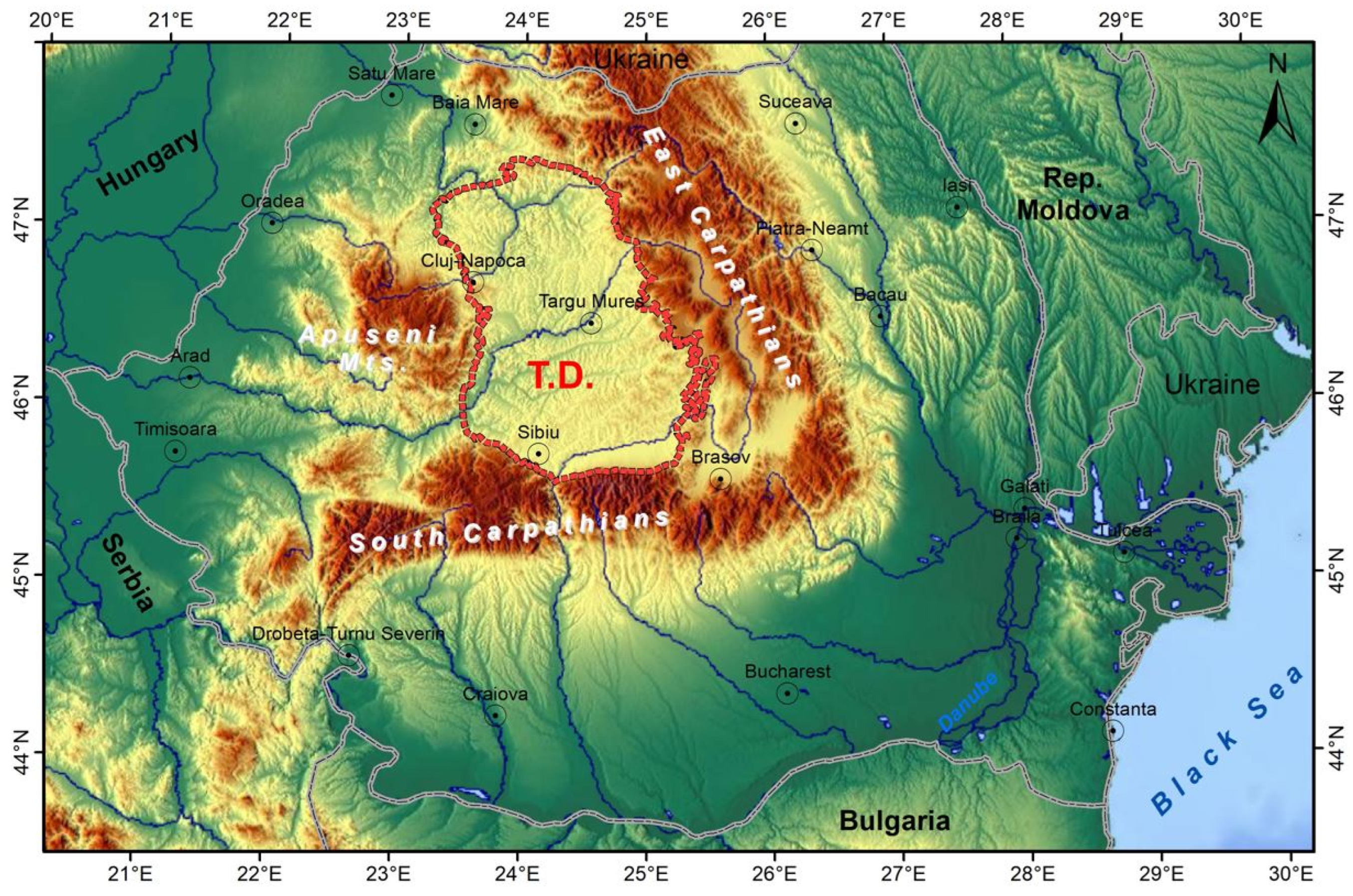
Figure 2.
Geological map of the Transylvanian Depression (modified after the Geological Map of Romania, scale 1: 1,000,000, Sandulescu et al., 1978) [18]. Purple line - geological boundary of he Transylvanian Depression [19].
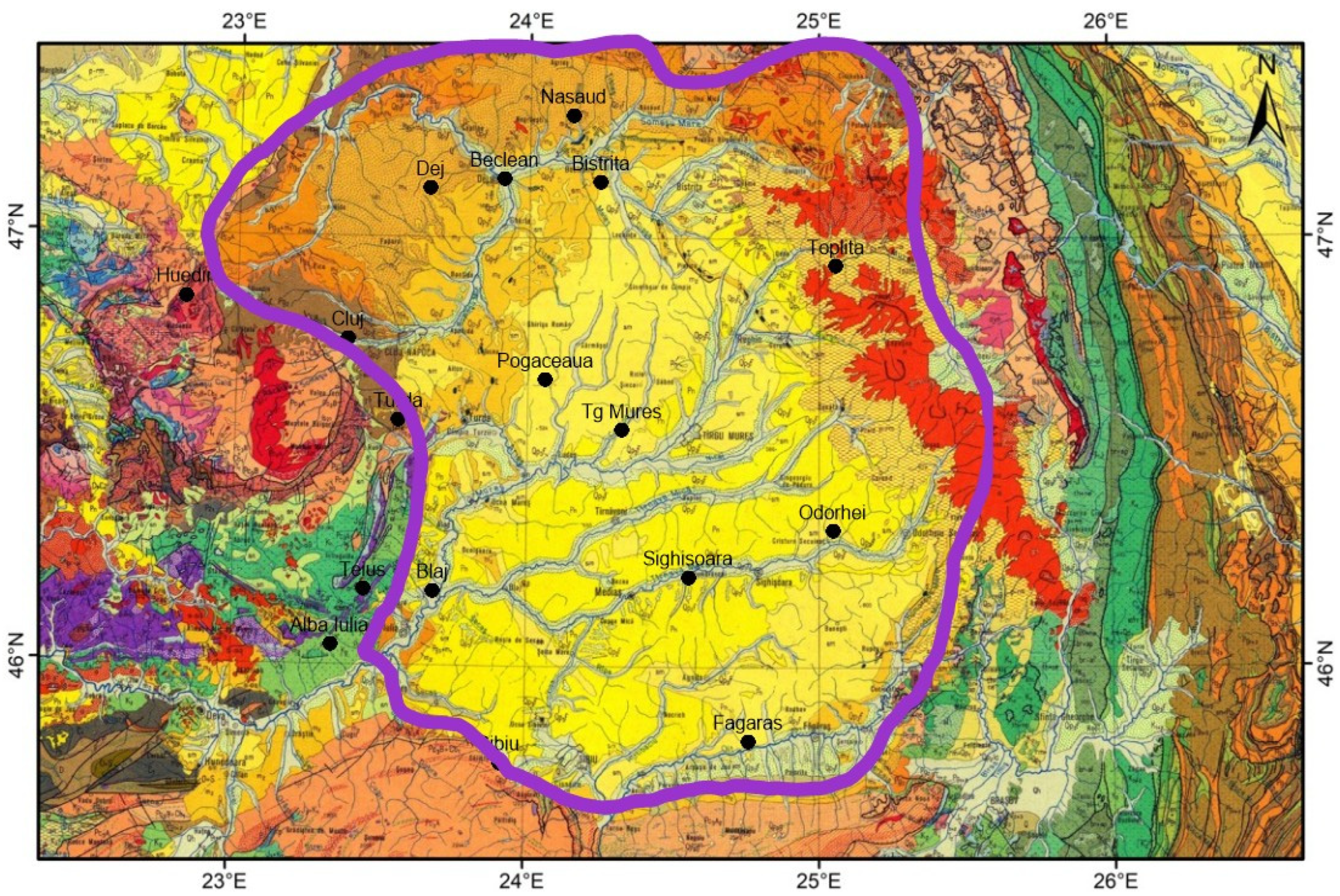
Figure 3.
Bouguer gravity map (modified after [22]. Purple line: geological boundary of the Transylvanian Depression [19]. Red and orange areas - high gravity anomalies; Green areas - low gravity anomalies.
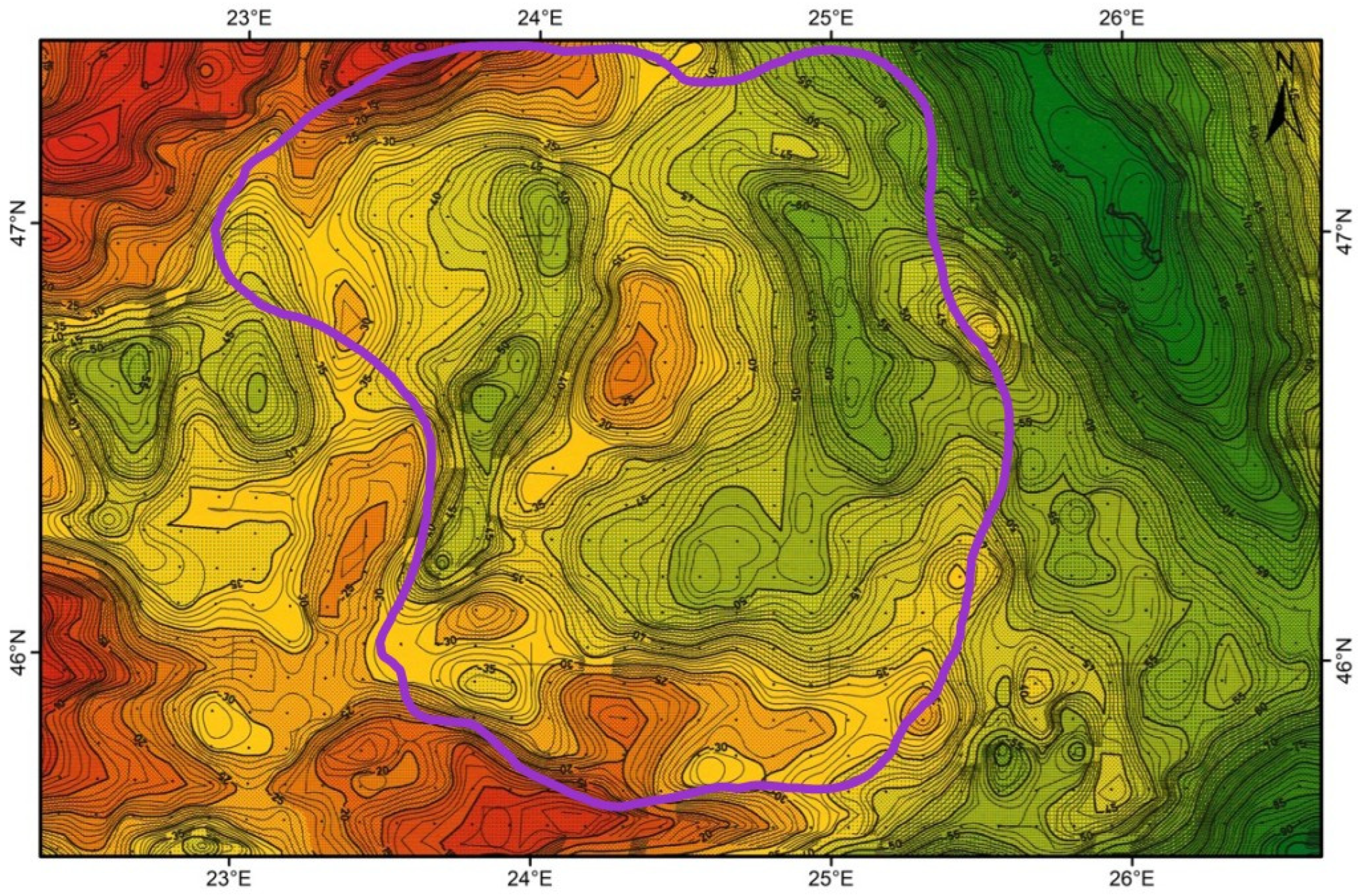
Figure 4.
Vertical Component anomaly of the Magnetic Field (modified after [23]. Red lines: positive anomalies; Blue line: negative anomalies. Purple line: geological boundary of the Transylvanian Depression [19].
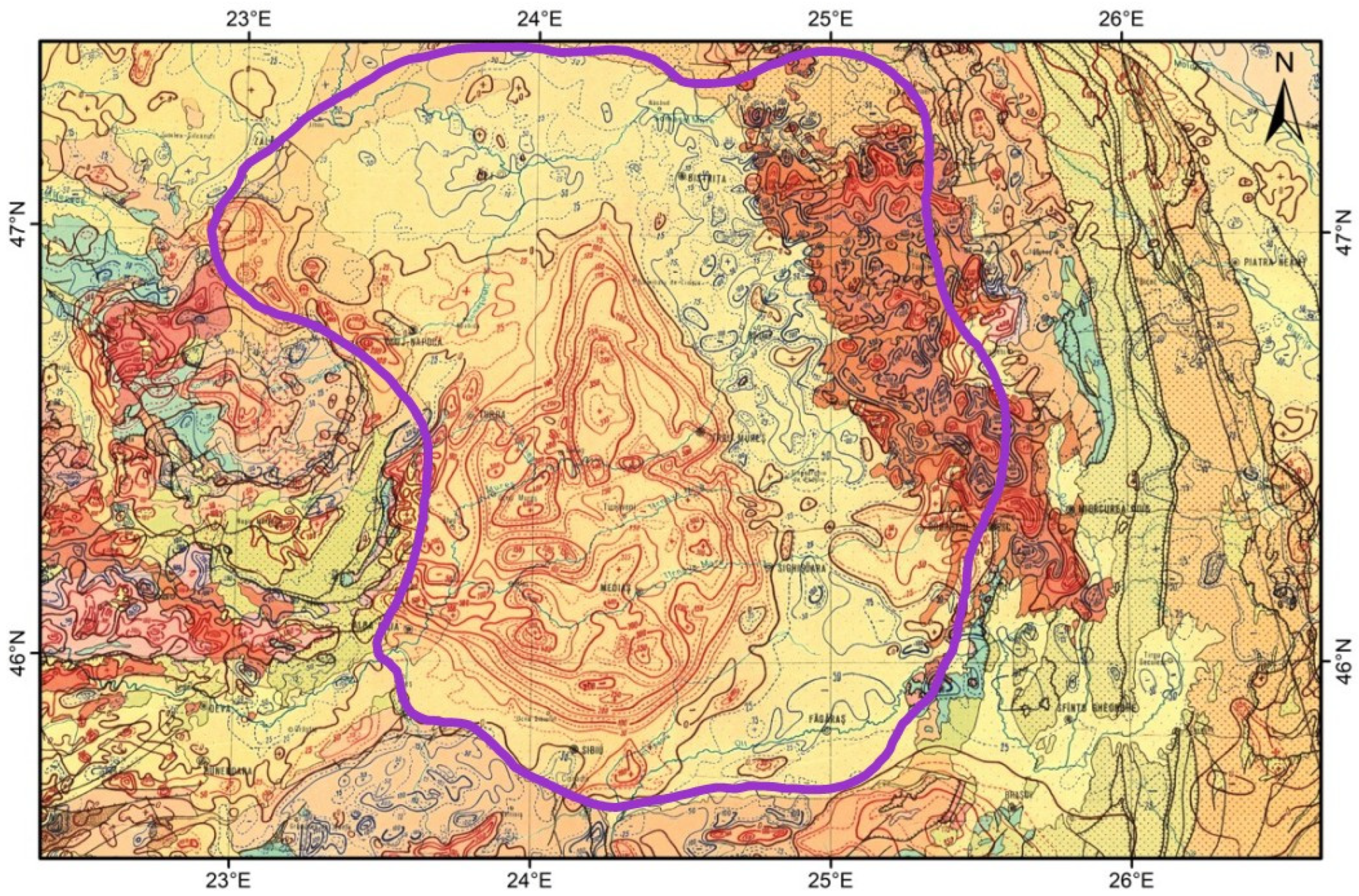
Figure 5.
Geological cross section across the Transylvanian Depression (modified after [19]. Pink layer: crystalline basement; Yellow layer: Triassic, Jurassic, Cretaceous, Paleogene and Lower Neogene sedimentary formations. White layer: Badenian Dej Tuff; Blue layer: Badenian Salt; Green layer: Sarmatian and Pliocene sedimentary formations. Vertical red lines: boreholes. Thick black lines: faults.
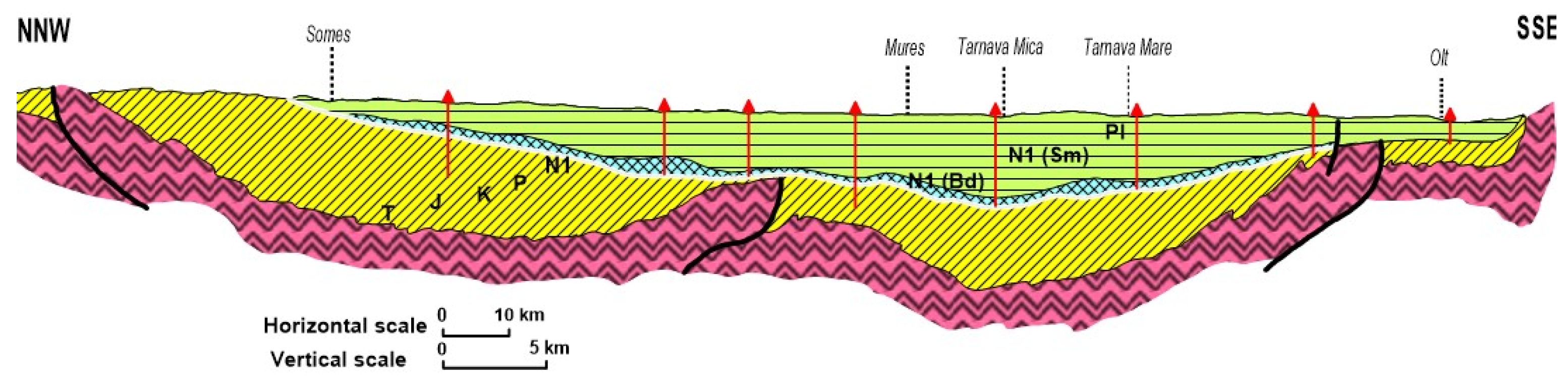
Figure 7.
Magnetic and gravity 2D modeling in the Transylvanian Depression based on refraction seismic data (modified after [24]. Magnetic data: Red line - measured aeromagnetic anomaly, Blue line - calculated anomaly; Gravity data: Black line - gravity regional anomaly, Green line - calculated anomaly; Seismic refraction data: RH1 – Hadareni tuff, RH2 – Dej Tuff, RH3 – crystalline basement. Geology: Pink layer – basement; Yellow layer - Lower and Middle Mesozoic, Cretaceous, Eocene, Oligocene, Lower Miocene; Blue layer – salt; Green layer: Badenian, Sarmatian and Pliocene; Upper crust: Blue rectangle – Magnetic crustal body.
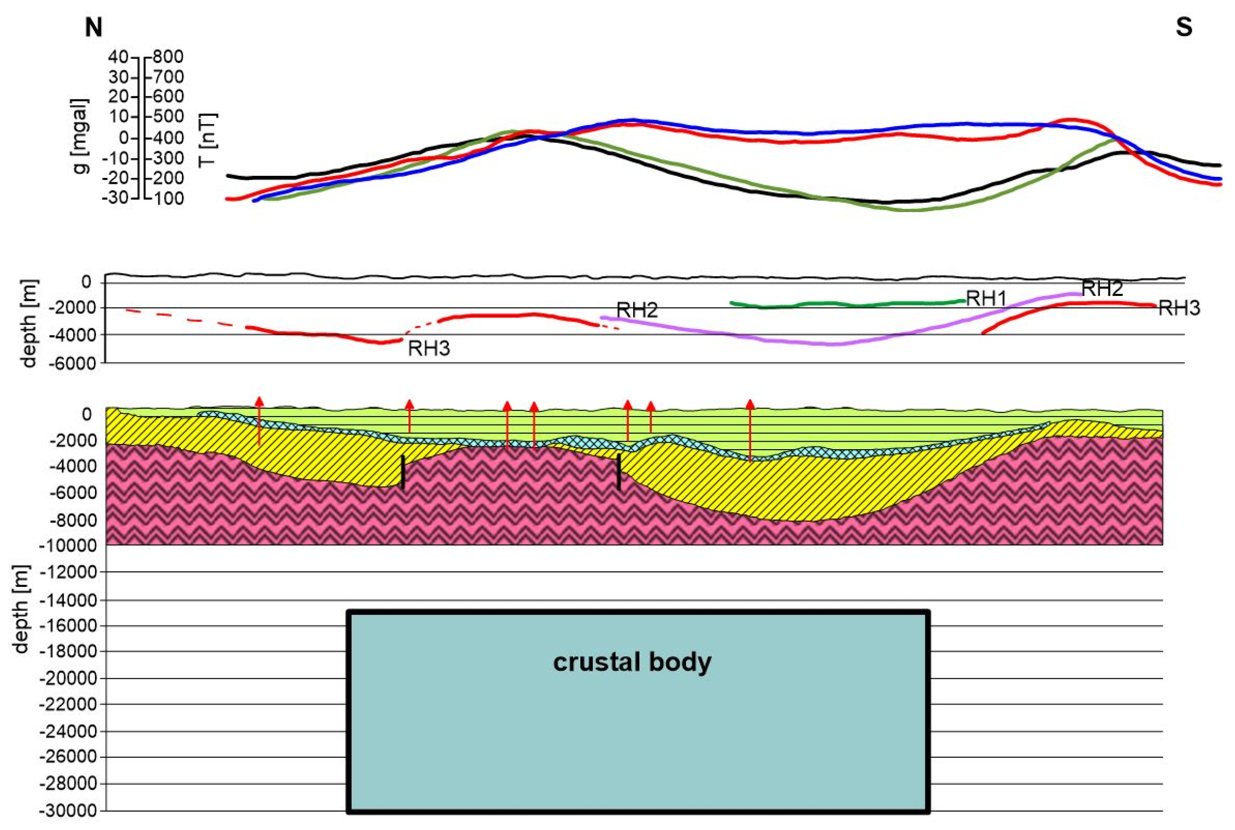
Figure 8.
Gravity stripping anomalies in the Transylvanian Depression (modified after [32]. Red areas: high gravity, Blue areas: low gravity. Purple line – geological boundary of the Transylvanian Depression [19].
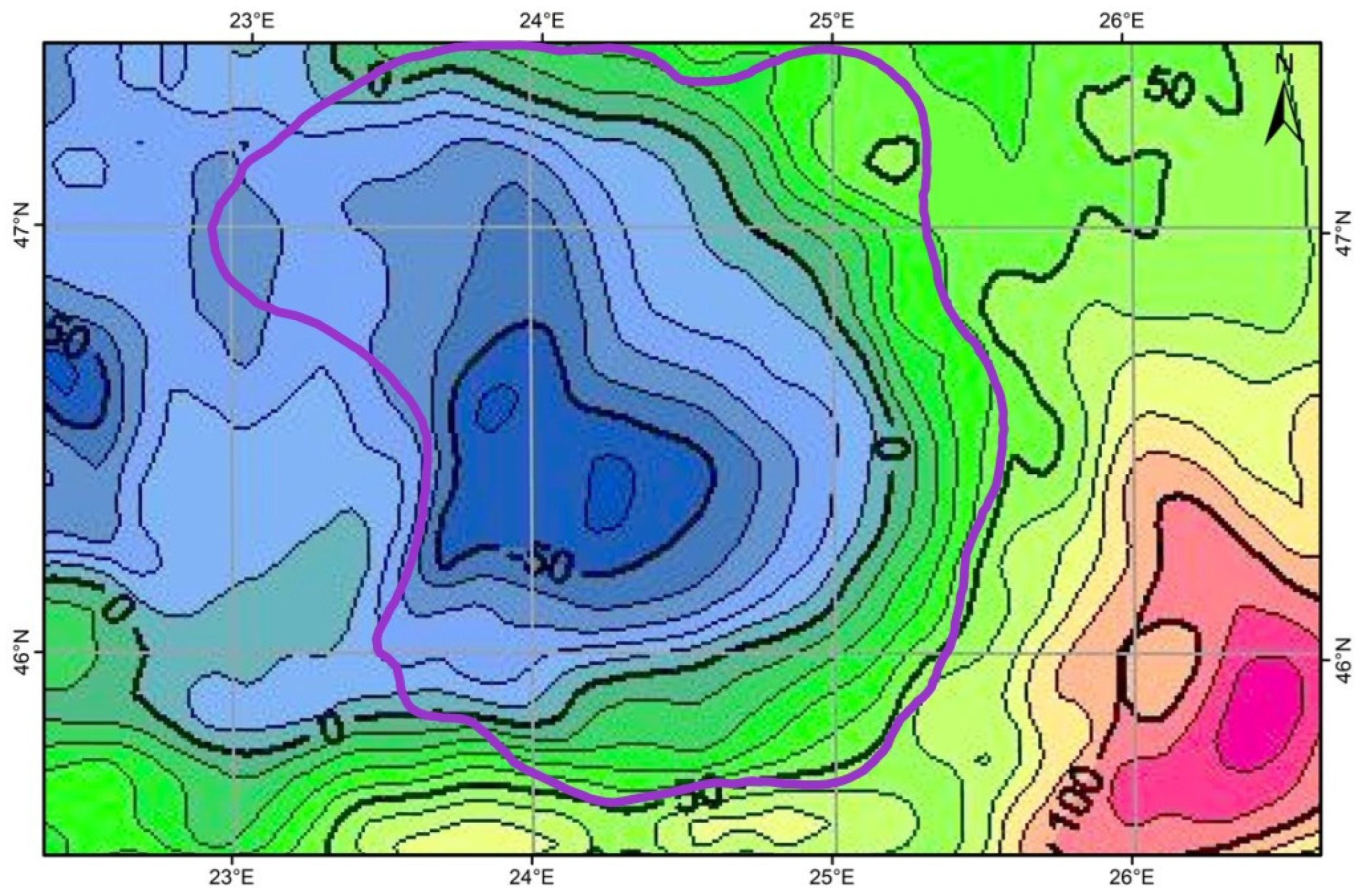
Figure 9.
– Transylvanian Depression (red ellipse) and Transylvanian Basin (purple ellipse), sensu [7]. Regional topographic map: H. Braxmeier (2017) https://maps-for-free.com/ accessed 2021 [16]. Black dots: salt bodies.
Figure 9.
– Transylvanian Depression (red ellipse) and Transylvanian Basin (purple ellipse), sensu [7]. Regional topographic map: H. Braxmeier (2017) https://maps-for-free.com/ accessed 2021 [16]. Black dots: salt bodies.
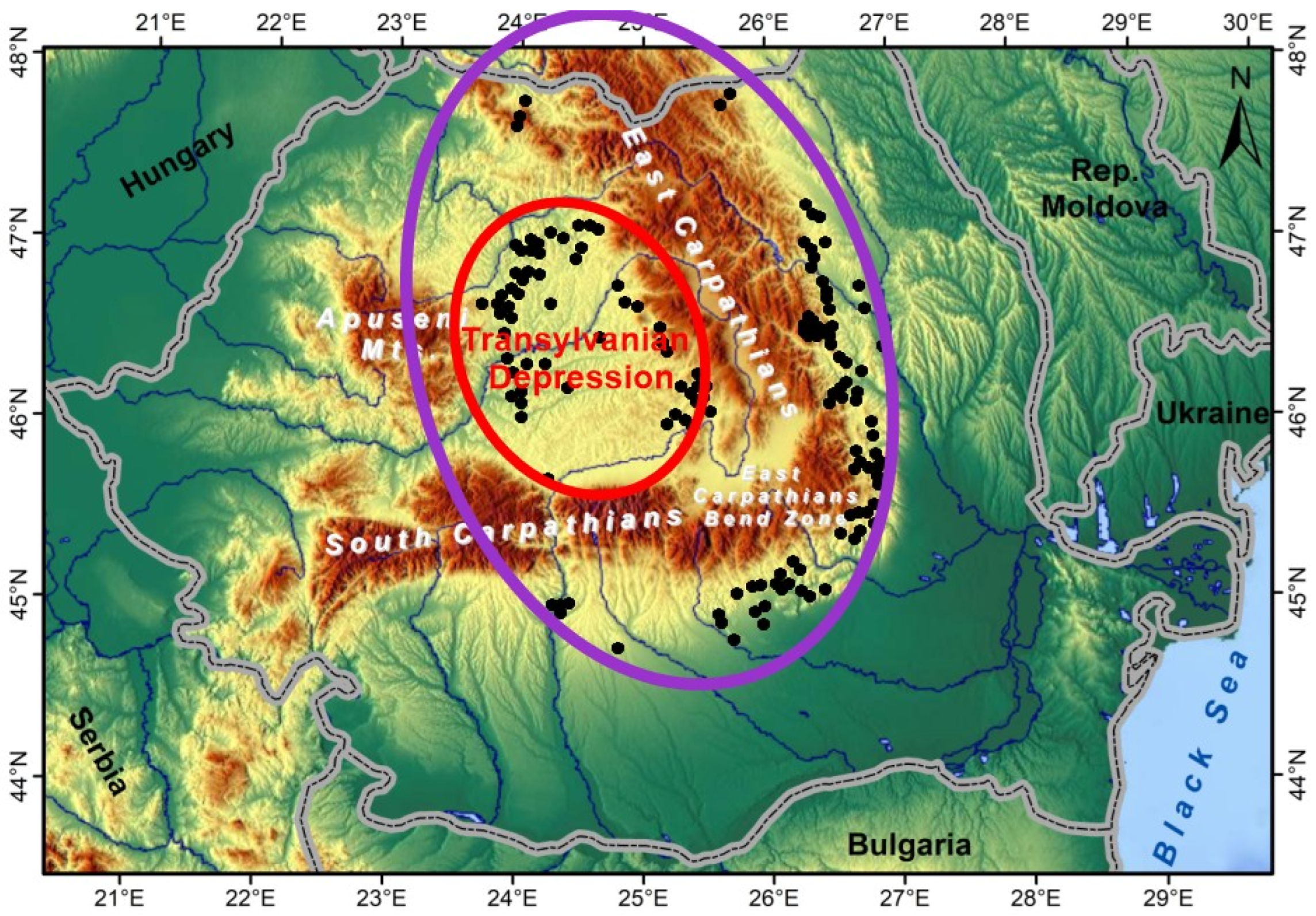

Table 1.
Characteristics of studied impacted sedimentary basins.
| Geological structure |
Precaspian Depression |
Alexandria Depression |
Transylvanian Depression |
|---|---|---|---|
| Geological age | Lower Permian | Upper Permian | Badenian (Lower Neogene) |
| Extinction event | Maokouan | Changsingian | Middle Miocene |
| Depression diameter | ≈ 700 km | ≈ 110 km | ≈ 175 km |
| Basin diameter | ? | ≈ 175 km | ≈ 300 km |
| Depth | more than 20 km | ca 10 km | ca 9 km |
| Salt layer thickness | 4 km | ca 350 m | ca 400 m |
| Oil and gas accumulations |
oil | oil | methane gas |
| Magmatism | no (too deep?) | intrusive and effusive |
intrusive (?) and extrusive |
| Gravity | gravity anomalies | gravity anomaly | gravity anomalies |
| Magnetics | magnetic anomalies | magnetic anomalies | magnetic anomaly |
| Seismic | refraction seismic | refraction seismic | refraction seismic |
| Seismic | reflection seismic | reflection seismic | - |
| Seismology | - | seismicity | - |
| Geothermics | - | - | geothermal systems |
| Geomorphology | no | no | no |
| Geology | conglomerate layer | conglomerate layer | conglomerate layer |
Disclaimer/Publisher’s Note: The statements, opinions and data contained in all publications are solely those of the individual author(s) and contributor(s) and not of MDPI and/or the editor(s). MDPI and/or the editor(s) disclaim responsibility for any injury to people or property resulting from any ideas, methods, instructions or products referred to in the content. |
© 2025 by the authors. Licensee MDPI, Basel, Switzerland. This article is an open access article distributed under the terms and conditions of the Creative Commons Attribution (CC BY) license (http://creativecommons.org/licenses/by/4.0/).
Copyright: This open access article is published under a Creative Commons CC BY 4.0 license, which permit the free download, distribution, and reuse, provided that the author and preprint are cited in any reuse.


