
Submitted:
18 March 2025
Posted:
18 March 2025
You are already at the latest version
Abstract
Mining has caused severe pollution, particularly in areas with poor regulation. The former Ávalos Foundry in Chihuahua City left toxic contamination after its closure in 1997, affecting nearby settlements. This study examines the socio-environmental impact on residents adjacent to the former foundry. The study area considered 5,773 dwellings, with 4,634 inhabited by 14,187 persons. A survey of 465 residents assessed sociodemographic aspects, environmental perceptions, and community participation. Tap water samples from 70 homes were analyzed for toxic metals, compared to Mexican, American and European regulatory. Using ArcGIS and interpolation, the study modeled water pollutant dispersion. Findings show residents face economic, social, environmental, and health issues due to ongoing contamination. Several suffer from respiratory and skin diseases linked to mining waste. While the majority consider their live comfortable or very comfortable, many would not have moved there if aware of the risks before. Despite concerns, most residents are reluctant to engage in community efforts to address pollution. Water tests revealed high levels of, arsenic, copper, chromium, iron, manganese, and nickel posing serious health risks. The study calls for immediate action, including awareness campaigns, health monitoring, environmental remediation, and collaboration among public, social, and educational sectors to secure funding and long-term solutions.
Keywords:
Metals and metalloids
; mining waste
; people perception
1. Introduction
Mining has long been an important source of economic resources, but unfortunately, it has left a legacy of pollution that has had detrimental consequences for human health and the environment. Despite the significant revenue it has generated, especially during metal boom periods, workers' movement to mining areas has not always been accompanied by adequate planning to mitigate the negative impacts on the environment. In addition, the use of outdated mining methods and the lack of compliance with environmental, mining, and health regulations have aggravated the problems associated with this activity [1].
One of the most significant risks associated with mining activity is the improper management of waste, which contains highly toxic components such as arsenic, cadmium, copper, lead, mercury, chromium, selenium, and zinc, among others [2]. The adverse effects of exposure to toxic metals are especially concerning in vulnerable populations, such as children and pregnant women. From prenatal development to adulthood and aging, exposure to those pollutants can cause a wide range of health problems, ranging from alterations in physical and intellectual development to reproductive effects and the increased risk of certain types of cancer [3].
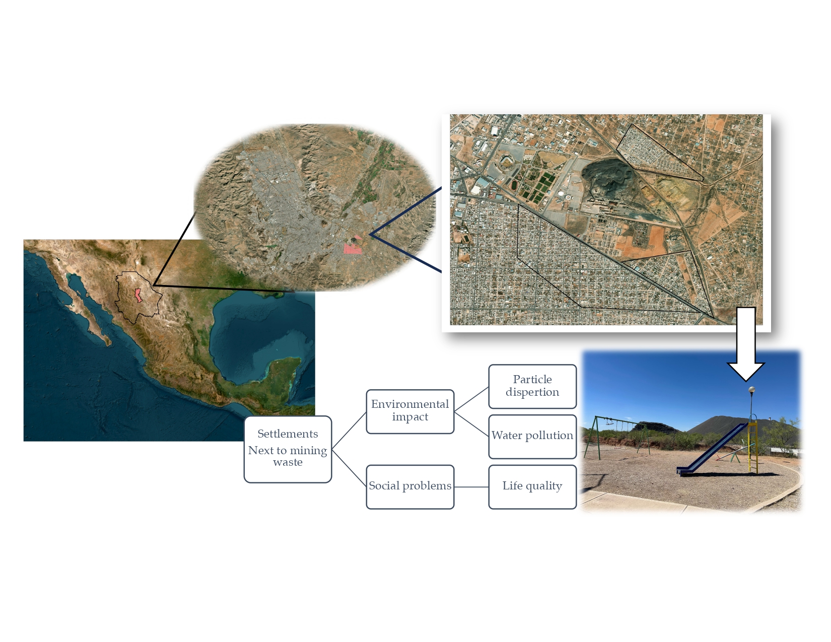
The former Avalos Foundry plant, located in the southeast of Chihuahua City, began operations on May 1, 1908. During its peak, it processed 600 metric tons of lead daily, sending it to Monterrey for refining. This site was one of the major industries in the region, processing mineral concentrates through pyrometallurgical processes [4].
Following the full stop of operations in 1997, the area went from being an industrial center to becoming a focus of environmental pollution. With more than 324 hectares affected, it represents the biggest environmental passive in Latin America. Lead particles and other wastes containing heavy metals in the soil have significantly affected nearby human settlements [4]. The area experienced a change in its urban use, going from being an industrial-oriented to a service-oriented area with the construction of bus terminals, supermarkets, government offices, and other public facilities. However, the pollution left by the foundry has continued to affect the health and well-being of the surrounding communities, as evidenced by the numerous complaints and sues from nearby residents [5].
Despite government efforts to address the problem, including environmental remediation plans announced in 2016 and 2017, those have not achieved an effective solution to mitigate the pollution impacts in the area [4]. The lack of action has generated growing concern among the affected population and has led the National Human Rights Commission (CNDH) to intervene, ordering urgent measures to protect the health and rights of the inhabitants in the affected neighborhoods [5]. However, the lack of effective solutions led to a state of abandonment of both industrial facilities and local areas, leaving a legacy of pollution and health problems that persist to this day.
Therefore, this research focused on realize the socio-environmental situation of the human settlements near the former foundry in Chihuahua City.
2. Materials and Methods
2.1. Study Area
The study area is located near the former Avalos smelter plan in the southeastern part of Chihuahua City, Mexico. The residential areas considered in this research were Villa Juarez (blue polygon), Veteranos (green polygon) and Rinconada Los Nogales (red polygon) (Figure 1).
2.2. Demographic and Housing Analysis in the Study Area
According provided data by the National Housing Institute (INVI) there are a total of 5,773 housing units in the study area, of which 4,634 are currently inhabited. The total population residing in this area is 14,187 individuals. Of this population, those considered eligible to participate in the evaluation instrument were individuals over 14 years of age, totaling 11,925 persons (Table 1 and Table 2) [6].
Based on the secondary zoning of the study area, as outlined in the Urban Development Plan of the Municipality of Chihuahua 2040 (PDU) in its seventh update [7], Rinconada Los Nogales has a housing density classification of H45, meaning a permitted housing density of 45 dwellings per hectare. In contrast, the surrounding area, which includes even halls and farms, has a mixed suburban land use classification, subdivided into MS and MS2, allowing for a maximum density of H45 and H35 (45 and 35 dwellings per hectare), respectively.
Meanwhile, the other neighborhoods in the study area (Villa Juarez and Veteranos) have a commercial land use along some main avenues and share the housing density classification of H35.
2.3. Population Perspective
2.3.1. Evaluation Instrument
An assessment instrument was developed in the software ArcGis Survey 123 (ESRI, Redlands, CA, USA), comprising 28 questions structured across different measurement scales: nominal, ordinal and interval. The primary objective of this instrument is analyzed key aspect of the people residing in the area next to the former foundry, categorized into the following dimensions:
- Sociodemographic characteristic: Included variables such as sex, age, household size, presence of vulnerable individuals, residence time in the area.
- Perception of the residential environment: Evaluated factors influencing settlement decisions, perceived comfort levels, awareness of environmental and health risks, and reported symptoms or health conditions associated with proximity to mining waste.
- Expectations from public administration and commitment: Identified priority actions from the resident’s perspective and highlights infrastructure and service deficiencies. In addition, analyzed the resident involvement level in activities related to environmental conservation and local improvement.
2.3.2. Sample Size
The sample size was determined with a 95% confidence level and a 5% error margin. The minimum number of surveys required to statistically represent the entire population was calculated to be 372. The estimated values were calculated using Equation (1).
where:
- n = Sample size.
- N = Population size.
- σ = Standart deviation.
- Z = Confidence level.
- e = Margin of error.
To ensure an adequate sample, 500 sampling points were planned, of which 465 surveys were successfully conducted and distributed among the neighborhoods in the study area as follows: Villa Juarez (280 surveys), Rinconada Los Nogales (98 surveys), and Veteranos (87 surveys).
2.4. Metals in Water
2.4.1. Sampling
Water samples were collected in 1L plastic bottles from 70 household taps in the sector. A non-probabilistic convenience sampling method was used, depending on the willingness of residents to allow water collection from their homes.
2.4.2. Sample Preparation and Analysis
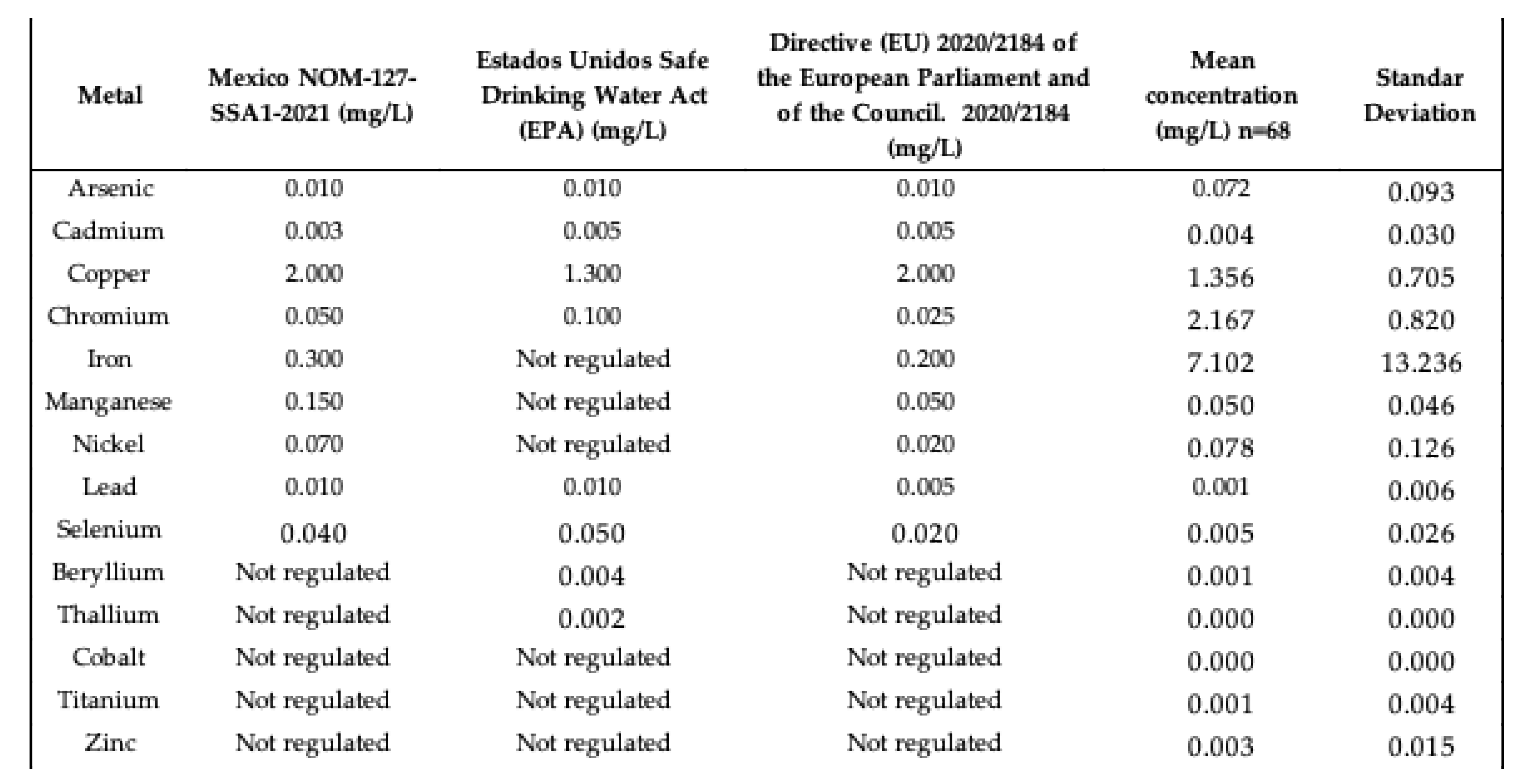
The water samples underwent an acid digestion process using an Anton Paar Multiwave Go digester, following the EPA 3015A method, with 10 mL of HNO3 y 4 mL de HCl. Metal and metalloid concentrations were determined using an Inductively Coupled Plasma Optical Emission Spectrometer (ICP-OES) (Perkin Elmer OPTIM-8300), with blanks and triplicate samples to ensure proper standard deviation and error calculation. The elements analyzed include Arsenic (As), Cadmium (Cd), Copper (Cu), Chromium (Cr), Iron (Fe), Manganese (Mn), Nickel (Ni), Lead (Pb), Selenium (Se), Beryllium (Be), Cobalt (Co), Titanium (Ti), Thallium (TI), and Zinc (Zn). The metal and metalloid concentrations were compared against the maximum permissible limits established by NOM-127-SSA1-2021 for water intended for human use and consumption [8], the United States Environmental Protection Agency in the National Primary Drinking Water Regulations [9], and Directive European Unión (EU) 2020/2184 On the quality of water intended for human consumption [10].
2.5. Data analysis and Modeling
The data obtained were visualized using ArcGis 10.8 software (ESRI, Redlands, CA, USA). To model contaminant dispersion in sector maps, the GeoStatistical Analyst Wizard (ESRI, Redlands, CA, USA) extension was used, employing the Inverse Distance Weighted (IDW) interpolation method.
The IDW method estimates the concentration of unsampled sites using existing values from the research area, where observations closest to the site have a greater influence than those farther away, with influence decreasing as distance increases. The estimated values were calculated using Equation (2):
where:
- Z(S0) = value to be estimated in place S0
- N = number of observations close to the place to be estimated,
- λ = weight assigned to each observation to be used, weight decreases with distance,
- Z(Si) = observed value of place Si.
3. Results
3.1. Sociodemographic Characteristic
465 inhabitants were interviewed, of which 52% were women and 41% were men, while 5% did not specify their gender. The respondents were all over 14 years old, the age group with the highest number of responses was the 45 to 49 age range, representing 12% of the total, followed by the 55 to 59 age group, with 11%, and the 60 to 64 age group, which provided 11% of the responses. Overall, adults and older adults constituted the predominant response groups, accumulating 34%.
Of the people surveyed, 29% completed secondary education, while 26% reached the high school level, only 16% finished university and 2% completed postgraduate studies (Figure 2). 32% of respondents have a formal job, which includes benefits such as vacations, social security and a stable income [11]. On the other hand, 24% of respondents reported being unemployed (Figure 3).
The dwellings are predominantly inhabited by 2 adults per dwelling from 20 to 60 years of age (47%), and zero adults over 60 years of age per dwelling (43%), or dwellings with 1 or 2 adults aged from 60 or older (with 28% in each category) (Figure 4). In addition, the dwellings are inhabited by children or young people in the 0 to 19 age group, with the dominant groups on 5 to 9 years (27%) and 15 to 19 (26%) (Figure 5).
The inhabitants of the study area have been living in the area for between 0 and 60 years or more. The most frequently mentioned time ranges were 0 to 10 years (24%) and 11 to 20 years (23%). This trend was observed more clearly in the Rinconada Los Nogales neighborhood, since it was established in 2005. In contrast, in the other two neighborhoods analyzed, a greater diversity of responses was obtained (Figure 6).
The main reasons indicated for choosing or remaining in this area were the affordable price of housing (44%) and the acquisition of housing through inheritance (40%). In the Rinconada Los Nogales neighborhood, the influence of the cost of housing predominates, while in the other two neighborhoods analyzed, both conditions have a significant weight (Figure 7).
3.2. Perception of the Residential Environment
Analysis of residents' perceptions of the comfort level in their surroundings revealed that 86% of residents consider that they live comfortably or even very comfortably (Figure 8). This high percentage suggests a strong association with the sense of belonging that residents have developed towards the place [12].
Although 53% of residents claimed to be informed about the risks associated with living near mining waste (Figure 9), 59% indicated that, had they known about these risks in advance, they would have chosen not to settle in the area (Figure 10). This result represents a paradox, since those who claimed to be aware of the risks still decided to reside in the place, while the majority said that they would not have done so if they had known about the dangers from the beginning. Given that, most people exposed to slowly or rapidly deteriorating environmental conditions do not migrate despite the availability of exit options [13].
Respondents indicated that the source of water they use is direct tap water (38%) and water dispenser (34%). Some consume bottled water (25%), and others mentioned that their source of supply was tap water with a filter to improve the quality of the water consumed (2%) (Figure 11).
Most of the inhabitants of the area indicated that neither they nor their family members living in the house suffer from symptoms of diseases (38%), however, 28% mentioned suffering from nasal congestion and respiratory diseases. There was also an incidence of responses of presenting dry skin (7%), extremities weakness (7%), chronic headache (5%), frequent nosebleeds (5%) and rash (4%), also, in the section of others they mentioned hypertension, diabetes and dizziness (Figure 12).
The respondents indicated that they or family members living in their house have not been diagnosed with any disease (51%), they reported suffering allergies (28%), as well as asthma or other respiratory diseases (20%). In other diagnosed diseases they mentioned osteoporosis, cancer, high blood pressure and diabetes (Figure 13).
Most people do not know anyone on their street who suffers from any type of chronic disease (78%) or genetic problems from birth (81%). The most frequently mentioned disease was cancer (9%), as well as kidney problems (3%), anemia (3%), cirrhosis (2%), among others. As for birth genetic conditions, the most frequent were Down syndrome (6%), autism (5%), developmental delay (4%), and cerebral palsy (3%) (Figure 14 and Figure 15).
Likewise, most respondents indicated that neither they nor anyone in their family living in their home suffers from any psychological or cognitive condition (66%), the dominant conditions were anxiety (9%), followed by depression (6%), hyperactivity (4%), and excessive aggressiveness (4%), (Figure 16).
The main problems identified by residents of the study area arising from proximity to mining waste were dust in homes (30%), in the streets (21%), and clothing (17%), totalizing 68% of the responses. Also mentioned contaminated water, bad smells, dead animals, lack of paving in the streets, water cuts, the presence of stray dogs and the insecurity generated by the presence of immigrants (Figure 17).
Therefore, residents of the area indicated that they carry out strategies to mitigate the impacts such as frequent cleaning of dust inside the homes (34%), keeping windows closed (31%), not consuming water from the area (22%), not using mechanical ventilation (7%), etc. Other responses mentioned included fumigation, watering the front of the homes and applying lime around them (Figure 18).
Even with all the above, 61% of respondents stated that they would not consider moving if the opportunity presented itself. In contrast, 39% indicated that they would be willing to make such a change (Figure 19). A greater positive response was observed in people who live in the Rinconada los Nogales neighborhood (Figure 20). These data reflect a majority tendency towards permanence in the current home, which could be influenced by factors such as owning the property and attachment to the place, even due to a lack of aspirations [13].
3.3. Expectations from Public Administration and Commitment
Residents of the area indicated that they were not aware of health campaigns promoted by the public administration (93%) (Figure 21). This suggests a possible lack of dissemination of these initiatives or a limited role of the public administration in the sector, which could negatively impact the participation and scope of health promotion strategies.
Residents mentioned that they were not aware of the implementation of relocation activities, while only 5% indicated that they were aware that these activities had been carried out (Figure 22), being more observed in the Rinconada Los Nogales than in the other two neighborhoods (Figure 23).
The residents of the area mentioned that they would ask to the public administration, to remove mining waste (45%), as well as to improve services (18%) and public infrastructure (13%), to remediate the wastes (12%) or to relocate it (8%) (Figure 24).
In services, they were asked to improve the water supply, public lighting, and public transportation. In infrastructure, they pointed out the streets paving, painting pedestrian crossings, improving the place security and increasing municipality cleaning.
Most of the population stated that they had no knowledge or had received information on how to prevent exposure to mining waste (94%). Only 6% of respondents stated that they had received some type of training or information on prevention, especially in their children's schools.
Most of the population indicated that they had not undergone blood tests to determine the lead concentration, only 20% responded affirmatively (Figure 25). Furthermore, few were aware of actions by the authorities to mitigate contamination in the study area, only 7% indicated that such measures had been implemented. In addition to the above, 32% of respondents indicated that they knew a neighbor or person close to them who had abandoned their home due to exposure to mining waste (Figure 26).
Respondents indicated significant concern about local pollution (52%), with responses ranging from 7 to 10. Likewise, they are concerned about the pollution impact on future generations (62%), with responses ranging from 7 to 10. However, a low percentage (15%) of respondents expressed their willingness to participate in their community in activities related to health and the environment, with responses ranging from 7 to 10. Only 34% of respondents responded affirmatively, rating the community’s ability to reduce pollution in their area with a score between 7 and 10 (Figure 27).
3.3.1. Metals in Water
Several metals and metalloids regulated by NOM-127-SSA1-2021 were analyzed in water: As, Cd, Cu, Cr, Fe, Mn, Ni, Pb, and Se [8]. Of these, Cd, Pb, and Se remained with values close to zero or not detected (ND). Other elements such as Be, Co, Ti, Tl, and Zn are not regulated by Mexican and/or international regulations, and most of these were determined as zero or not detected (ND) (Table 3).
69% of the water samples exceeded the maximum permissible levels (MPL) established for As by Mexican, American, and European regulations (Table 3). The map (Figure 28) shows that all the study area affected by this metalloid in water. However, the elevated presence may be due to natural causes related to the geological characteristics of Chihuahua, as indicated by Ren et al. (2022), who reported that groundwater from wells around Chihuahua contains a high level of this metalloid, also identified As minerals in the cavities of the Tertiary volcanic tuff, in the northwestern part of the Tabalaopa basin, Chihuahua City [14].
Most water samples (82%) fell within the MPLs for Cu established by Mexican and European regulations, while 65% of the samples exceeded the MPLs defined in the United States. The map (Figure 29) shows the Cu distribution above the MPLs in specific areas of the Veteranos and Rinconada Los Nogales neighborhoods. Gutiérrez et al. (2012) associated the elevated presence of Cu with its mobility from sediments originating in Tertiary volcanic rock, which predominates in the western region of the study area, an observation that is consistent with the proximity of the area analyzed in the present work [15].
99% of the samples exceed the MPLs established for Cr by Mexican, American, and European regulations (Table 3). The map shows that the entire study area is subject to the problem of this metal in water (Figure 30). Cr in aquatic environment is mainly from natural sources, but, human activities have increased their concentration, is also highly soluble in water and has prolonged persistence in the environment [16]. The biggest problem is seen in speciation, since CrVI is much more toxic [17]. Therefore, a new study evaluating the chemical form of chromium present in drinking water is recommended to accurately determine the potential risk to public health.
Most water samples (79%) exceed the MPLs for Fe established by Mexican, American, and European regulations. The map (Figure 31) shows that almost the entire study area has high concentrations of this metal. The abundant presence of Fe has been documented in previous studies, such as that of Gutiérrez et al. (2021), who attribute its geogenic origin to two sources: primary and secondary. The primary origin refers to the dissolution of the parent rock, while the secondary origin is related to the release of contaminants retained in secondary minerals formed during the weathering of the original rock, including iron oxides and clays [18].
97% of the water samples met the MPLs for Mn established by Mexican and U.S. regulations, while only 74% met the requirements of the European regulations. The map (Figure 32) reveals that, under Mexican regulations, the problem is concentrated in very specific areas, with the largest concentration being in the Rinconada Los Nogales neighborhood (North) where the European regulations apply. The presence of this element in the state of Chihuahua has been documented by Ponce-González et al. (2024), who found significant concentrations in the southern area of Laguna de Encinillas, located in Chihuahua, Mexico. Its origin is geogenic and linked to the volcanic rocks of the surrounding mountain ranges. It is worth noting that the study area is located less than 140 kilometers south of Laguna de Encinillas and coincides with the presence of these mountain ranges [19].
66% of the samples meet the MPL for Ni established by Mexican and U.S. regulations, while only 47% meet the MPL stipulated by European regulations. The map (Figure 33) shows that residential areas in the study area are affected by the presence of this metal in water. The literature does not specifically report its presence, suggesting that its origin could be due to factors other than geology or the normal composition of the subsoil. However, it is important to highlight the high concentrations found in the core area of the study site, i.e., in the tailings.
4. Discussion
Most of the respondents were adults over 24 years of age, with a high school or secondary education level, and with a fixed income. The length of residence varied from 0 to more than 60 years, with those who have lived there between 0 and 20 years predominating. The choice of housing was mainly based on whether it was affordable or inherited. A mix of young families was observed, especially those who acquired affordable housing, and older adults who have lived there for more than 20 years. It is relevant to consider vulnerable groups such as children and pregnant women, since, when forming a family, they tend to acquire affordable housing near environmental liabilities, which could permanently affect their quality of life [20].
The responses obtained reflect the perspective of the inhabitants on the proximity of the former Ávalos smelter, based on empirical and non-professional knowledge. Despite the risks, most people feel comfortable in the area, which may be related to the sense of belonging and the accessibility of services such as access routes, health and educational centers, which favor their comfort [21]. However, it was contradictory that, although most people said they would not have lived near the mining waste if they had known the risks, they continued to live in the area. This reflects the confusion and contradictions generated by exposure to contamination [22].
This indicates that the socioeconomic factor influences the decision to live in this area, and the lack of environmental education could explain the lack of awareness about the risks associated with living near environmental liabilities, since invisible threats are usually less perceived [23].
Residents in the study area use water from tanks or the public network as being of poor quality, which leads them to use filters, buy bottled water or water from retailers, due to uncertainty about the effects of contamination [22].
However, the risk of developing diseases increases with proximity to contaminated sites [24]. Although many residents reported not having symptoms, it is important to highlight that the adverse effects of prolonged exposure to mining waste mainly affect vulnerable groups such as children, the elderly and pregnant women [25]. Residents mainly reported respiratory diseases associated with contamination, such as allergies and asthma [26].
To better understand health problems, they were asked indirectly if they knew anyone with diseases, avoiding invasive questions [27]. Although many did not mention chronic or genetic diseases, reported cases included cancer, kidney disease, and anemia. Birth problems such as Down syndrome, autism, and developmental delay were also mentioned, which entail high health care costs and affect the quality of life of families [28].
Dust was identified as the main environmental problem, affecting clothing, housing, and uncovered water tanks. To mitigate the impact, residents adopted measures such as frequent cleaning and closing doors and windows. Regarding the sense of belonging, most residents of older neighborhoods such as Villa Juárez and Veteranos would not want to move, unlike the Rinconada Los Nogales neighborhood, where the feeling of belonging is lower [29].
The effects of environmental impacts may not be evident in the short term, and their assessment is complicated by the lack of visibility in the relationship between pollution and health [30]. Residents often justify illnesses by associating them with age or work factors, minimizing the importance of remediating environmental liability [31]. Furthermore, in situations of high pollution, the affected population tends to associate responsibility with the government or higher entities [22]. To improve the perception of government action, the requests of affected residents must be effectively addressed, in line with recommendation No. 91/2019 of the CNDH [5].
The environmental liability in the area affects not only the houses, but also nearby places such as the South Sports Complex, a medical unit and the market, exposing those who visit them to contamination. The problem intensified when urban facilities such as sports spaces were located near the liability, which affects users without them being aware of it, coinciding with Díaz (1996), who mentions the use of contaminated sites in urban works due to ignorance of the environmental impact [32].
Regarding health, most people do not know if prevention campaigns have been carried out, and in the Rinconada Los Nogales neighborhood, some residents have been relocated by the State Government [5]. Likewise, a majority considers that no remediation measures have been taken in the area, although minor works have been carried out. However, the source of the problem has not been addressed: the mining tailings and the contaminated soil from the former smelter. In addition, there are reports of home abandonment due to pollution, especially in Rinconada Los Nogales, which is the most affected neighborhood due to its proximity to mining tailings (Figure 1).
A high number of residents express concern about pollution and the impact it will have on future generations. Despite this, most are not willing to participate in activities to improve health and the environment. However, a high percentage still believe they can make a difference as a community to reduce pollution. This suggests that, although residents are aware of the magnitude of the problem, they prefer to ignore it rather than act [33].
Although several metals have very low or zero concentrations, arsenic, copper, chromium, iron, manganese, and nickel exceed the maximum permissible limits for human consumption, regardless of whether the source is natural or anthropogenic due to mining waste, the population is exposed to these contaminants, which can harm their health. As can cause serious health problems, including skin, bladder, and lung cancer, in addition to affecting cardiovascular and neurological function [34]. Cu is an essential nutrient for humans, animals, and plants, but it can pose risks to human health with elevated exposure like gastrointestinal problems [35]. Cr is one of the main elements required for the metabolism of carbohydrates and fats. Further, Cr increases insulin sensitivity by correspondingly increasing the binding of insulin to cells and the number of insulin receptors. The biggest problem is seen in speciation, since CrVI is much more toxic [36]. Iron is an essential mineral required for various bodily functions, such as transporting oxygen, takes part in oxyhemoglobin mechanism, supporting metabolism, and maintaining healthy skin and hair. However, its overload causes severe health problems in human beings such as liver cancer, diabetes, cirrhosis of liver, hear diseases and infertility [37]. Although, Mn is essential at low concentrations, high levels can cause neurological problems, especially in children, and affect water quality [38]. Ni can cause adverse effects on the respiratory and renal systems [39].
A work by González-Horta et al. (2015), comments that a significant number of residents in the southwestern part of the city of Chihuahua (this area includes Avalos), are chronically exposed to high As and Fluoride (F) levels in drinking water. Likewise, they report that antagonistic and synergistic effects have been reported between these two elements and their consequences for people's health. They even suggest taking immediate measures to reduce exposure [40].
5. Conclusions
The population surrounding the mining tailings of the former Ávalos smelter suffers economic effects, such as having to buy bottled water, water from a retail outlet or filters for their homes or even abandon their homes due to exposure. They also suffer social effects such as having to clean their homes more often, keeping doors closed and not using much mechanical ventilation, all due to excessive dust, as well as constant concern about the problem in the area. There are also environmental effects due to the exposure of the entire environment, both in water, soil and air, to the contaminants present in the mining tailings. In addition, there are effects on public health due to the presence of recurrent diseases, especially of a respiratory or skin nature.
Although many inhabitants consider that their quality of life is acceptable, several say that, if they had known the risks, they would not have lived there. In the Rinconada Los Nogales neighborhood, the majority would be willing to move, while in the Veteranos and Villa Juárez neighborhoods, those who do not want to change homes due to emotional or inherited attachment to their homes predominate.
The situation perception is mixed, with some demanding urgent action, but most feeling that they are not receiving support from the authorities. The historical importance of the former Ávalos smelter is highlighted, which could be transformed into a revitalized space, which would have a positive impact on the area and the community.
The metal concentration in water reveals significant variations in the quality of tap water. The high presence of arsenic, copper, iron and manganese poses serious challenges for public health, since these concentrations may be due to natural processes in the subsoil. On the other hand, the findings of chromium and nickel highlight the need to adjust regulatory criteria and strengthen monitoring and mitigation strategies in the mining tailings located in Ávalos. These results underline the importance of carrying out additional studies that consider both the chemical form of the contaminants and the specific sources of exposure, to develop targeted and effective interventions.
The study suggests immediate interventions, such as awareness campaigns on the risks, health monitoring, and reducing population density in nearby areas. In addition, it is recommended not to allow more housing in already consolidated areas, and to accelerate environmental remediation efforts. The collaboration of public administration, social and educational organizations is essential to find funds and remedy the problem.
Author Contributions
Conceptualization, M.C.V.A., M.C.N.R., and C.G.G.G..; methodology, M.C.VA., G.V.Q., G.S.A.D.R., and L.C.P..; software ArcGis Survey, I.Z.I.L., C.D.P.O., and D.L.H.; formal analysis, D.L.H., I.Z.I.L., and C.D.P.O.; investigation, M.C.N.R; resources, M.C.V.A..; data curation, C.D.P.O., D.L.H., L.C.P., D.L.H., G.V.Q., and G.S.A.D.R.; writing—original draft preparation, M.C.N.R., G.V.Q., L.C.P., M.C.V.A., D.L.H., and C.D.P.O..; writing—review and editing, C.G.G.G., and M.C.V.A..; visualization, M.C.V.A.; supervision, M.C.V.A.; project administration, M.C.V.A.; funding acquisition, M.C.V.A., G.V.Q., and C.G.G.G.
Funding
This research was funded by AUTONOMOUS UNIVERSITY OF CHIHUAHUA, grant number UACH-DAJ 183/2024, Convocatoria mas Ciencia, mas Investigación, mas UACH.
Institutional Review Board Statement
Not applicable.
Informed Consent Statement
Not applicable.
Data Availability Statement
Data are contained within the article.
Conflicts of Interest
The authors declare no conflicts of interest.
Abbreviations
The following abbreviations are used in this manuscript:
| CNDH | National Human Rights Commission |
| PDU | Urban Development Plan of the Municipality of Chihuahua 2040 |
| ICP-OES | Inductively Coupled Plasma Optical Emission Spectrometer |
| EU | European Union |
| IDW | Inverse Distance Weighted |
| MPL | Maximum Permissible Levels |
References
- Aparicio, M. Los riesgos de la contaminación minera y su impacto en los niños. Tinkazos [online] 2009, 12, 27, 83-101.
- Menéndez, J.; Muñoz, S. Contaminación del agua y suelo por los relaves mineros. Paideia XXI 2021, 1, 141–154. [Google Scholar] [CrossRef]
- Rivera, J.; Barrientos, T.; Oropeza, C. Síntesis sobre políticas de salud. Propuestas basadas en evidencia. Instituto Nacional de Salud, Cuernavaca, México, 2021.
- SEMARNAT. Ex Fundidora, Planta Ávalos Chihuahua, Chihuahua. Secretaría de Medio Ambiente y Recursos Naturales. Available online: https://www.gob.mx/semarnat/acciones-y-programas/ex-fundidora-planta-avalos-chihuahua-chihuahua (accesed on 3 november 2024).
- CNDH. Recomendación No. 91/2019 sobre el caso de violaciones a los derechos humanos al medio ambiente sano, salud, vivienda e interés superior de la niñez, por la contaminación del pasivo ambiental “Ávalos” y la construcción del fraccionamiento Rinconada Los Nogales, en Chihuahua, Chihuahua. Comisión Nacional de los Derechos Humanos. Available online: https://www.cndh.org.mx/sites/default/files/documentos/2019-11/Rec_2019_091.pdf (accesed on 15 march 2024).
- Instituto Nacional de Estadística y Geografía (INEGI). Inventario Nacional de Viviendas 2020. Available online: https://www.inegi.org.mx/app/mapa/espacioydatos/?app=inv (accesed on 10 november 2025).
- IMPLAN. Estructura urbana del PDU, Séptima Actualización. Instituto de Planeación Integral del Municipio de Chihuahua. Available online: https://implanchihuahua.org/IMPLAN-Datos/5.6.EstrategiaParaLaAdmonDelSuelo/5.1.EstrategiasPrincipales/5.1.4%20Estructura%20urbana/5.1.4.%20Estructura%20Urbana_13072023.pdf (accessed on 30 october 2024).
- SSA. NOM-127-SSA1-2021. Agua para uso y consumo humano. Límites permisibles de la calidad del agua. Secretaría de Salud. Diario Oficial de la Federación. México. Available online: https://www.dof.gob.mx/nota_detalle.php?codigo=5650705&fecha=02/05/2022#gsc.tab=0 (accessed on 15 January 2025).
- EPA. National Primary Drinking Water Regulations. United States Environmental Protection Agency. Available online: https://www.epa.gov/ground-water-and-drinking-water/national-primary-drinking-water-regulations#one (accessed on 15 January 2025).
- EU. On the quality of water intended for human consumption. Directive (EU) 2020/2184 of the European Parliament and of the Council. Available online: https://eur-lex.europa.eu/legal-content/EN/TXT/?uri=legissum:4499769 (accessed on 15 January 2025).
- Madero Gómez, S M.; Calderón Leyva, V.; Vélez Torres, F. Preferencias de las personas a las prestaciones y beneficios en su lugar de trabajo: Caso de una empresa maquiladora en la frontera noroeste México-Estados Unidos. Nova scientia 2015, 7, 529-552. ISSN 2007-0705.
- Navarro González, M.I.J. Niveles de saneamiento para suelo con pasivos ambientales. Estimación de factores de exposición para México. Revista AIDIS de ingeniería y ciencias ambientales: Investigación, desarrollo y práctica, 2006, 1, 1. ISSN 0718-378X.
- Czaika, M.; Reinprecht, C. Why do people stay put in environmentally stressful regions? Cognitive bias and heuristics in migration decision-making. Regional Environmental Change 2022, 22, 84. [Google Scholar] [CrossRef]
- Ren, M.; Rodríguez-Pineda, J.A.; Goodell, P. Mineral de arsénico en toba volcánica, una fuente de anomalía de arsénico en aguas subterráneas: Ciudad de Chihuahua, México. Geociencias 2022, 12, 69. [Google Scholar] [CrossRef]
- Gutiérrez, M.; Reyes-Gómez, V. M.; Alarcón-Herrera, M. T. López, D. N. Exploratory analysis of sediment geochemistry to determine the source and dispersion of Ba, Fe, Mn, Pb and Cu and in Chihuahua, Northern Mexico. Journal of Geography and Geology 2012, 4, 26. [Google Scholar] [CrossRef]
- Ahmed, M.F.; Mokhtar, M.B. Assessing cadmium and chromium concentrations in drinking water to predict health risk in Malaysia. International Journal of Environmental Research and Public Health 2020, 17, 2966. [Google Scholar] [CrossRef] [PubMed]
- Vasseghian, Y.; Almomani, F.; Dragoi, E.N. Health risk assessment induced by trace toxic metals in tap drinking water: Condorcet principle development. Chemosphere 2022, 286, 131821. [Google Scholar] [CrossRef] [PubMed]
- Gutiérrez, M.; Espino-Valdés, M. S.; Alarcón-Herrera, M. T.; Pinales-Munguía, A.; Silva-Hidalgo, H. Arsénico y flúor en agua subterránea de Chihuahua: origen, enriquecimiento y tratamientos posibles. Tecnociencia Chihuahua 2021, 15, 95–108. [Google Scholar] [CrossRef]
- Ponce-González, F.; Villalobos-Aragón, A.; Espejel-García, V.V.; Espejel-García, D. Geochemical Characterization of Soils in the Playa Lake Environment of Laguna de Encinillas, Chihuahua, Mexico. Open Journal of Geology 2024, 14, 900–918. [Google Scholar] [CrossRef]
- Atienzo, E.; Campero, L.; Lozada, A.L.; Herrera, C. Aspiraciones educativas y familiares como condicionantes en la prevención de embarazos tempranos en México. Salud pública de México [online] 2014, 56, 3, 286-294.
- De Pablos, J.; Sánchez, L. Estilos de vida y revitalización del espacio urbano. Papers. Revista de Sociología 2003, 71, 11-31. [CrossRef]
- Auyero, J.; Swistun, D. Expuestos y confundidos. Un relato etnográfico sobre sufrimiento ambiental. Íconos - Revista de Ciencias Sociales 2007, 28, 137–152. [CrossRef]
- Ursino, S. V. Paisaje contaminado ¿visible o invisible? Representaciones sociales de la contaminación ambiental y prácticas espaciales en los barrios más afectados de Dock Sud. Maestría “Paisaje, Medioambiente y Ciudad”, Universidad Nacional de La Plata - Facultad de Arquitectura y Urbanismo, La Plata, Argentina, Febrero 2012.
- ATSDR. Resúmenes de Salud Pública – Arsénico. Agency for Toxic Substances and Disease Registry. Available online: https://www.atsdr.cdc.gov/es/phs/es_phs2.html (accessed on 12 January 2025).
- Tovar, M.; Losada, G.; M.; García, T. Impacto en la salud por el inadecuado manejo de los residuos peligrosos. Ingenierías USBMed 2015, 6, 2, 46-50. [CrossRef]
- Torno, S. Emisiones de material particulado en almacenamiento de minerales a la intemperie. Doctoral thesis, PhD in Mining, Civil Engineering and the Environment, University of Oviedo, Oviedo, España, Available online: https://digibuo.uniovi.es/dspace/handle/10651/15060, accessed on 24 january 2025).
- Feria, H.; Matilla, M; Mantecón S. La entrevista y la encuesta: ¿métodos o técnicas de indagación empírica?. Didasc@lia: Didáctica y Educación 2020, 11, 3, 62-79.
- Grau, C.; Fernández, M. Familia y enfermedad crónica pediátrica. Anales Sis San Navarra [online] 2010, 33, 2, 203-212.
- Hombrados, M. I.; López, T. Dimensiones del sentido de comunidad que predicen la calidad de vida residencial en barrios con diferentes posiciones socioeconómicas. Psychosocial Intervention 2014, 3, 159–167. [Google Scholar] [CrossRef]
- Observatorio de Conflictos Mineros de América Latina. Pasivos ambientales mineros, barriendo bajo la alfombra. Consuelo Infante. Available online: https://www.ocmal.org/wp-content/uploads/2017/03/pasivos_22.pdf (accessed on 2 February 2025).
- ASGMI. Manual para el Inventario de Minas Abandonadas o Paralizadas. Grupo de Expertos en Pasivos Ambientales Mineros. Available online: https://asgmi.org/wp-content/uploads/2020/06/Manual-Inventario-PAM-y-Anexos.pdf?utm (accessed on 13 February 2025).
- Díaz, F. Los residuos peligrosos en México. Evaluación del riesgo para la salud pública de México. Salud pública de México [online] 1996, 38, 4, 280-291. [CrossRef]
- Wachinger, G. Renn, O., Begg, C., & Kuhlicke, C. The risk perception paradox—implications for governance and communication of natural hazards. Risk analysis 2013, 33, 1049–1065. [Google Scholar] [CrossRef] [PubMed]
- Palma-Lara, I.; Martínez-Castillo, M.; Quintana-Pérez, J.C.; Arellano-Mendoza, M.G; Tamay-Cach, F.; Valenzuela-Limón, O. L.; García-Montalvo, E.A.; Hernández-Zavala, A. Arsenic exposure: A public health problem leading to several cancers. Regulatory Toxicology and Pharmacology 2020, 110, 104539. [Google Scholar] [CrossRef] [PubMed]
- Taylor, A. A.; Tsuji, J. S.; Garry, M. R.; McArdle, M. E.; Goodfellow, W. L.; Adams, W. J.; Menzie, C. A. Critical review of exposure and effects: implications for setting regulatory health criteria for ingested copper. Environmental management 2020, 65, 131–159. [Google Scholar] [CrossRef] [PubMed]
- Vasseghian, Y.; Almomani, F.; Dragoi, E. N. Health risk assessment induced by trace toxic metals in tap drinking water: Condorcet principle development. Chemosphere 2022, 286, 131821. [Google Scholar] [CrossRef] [PubMed]
- Rahman, I.; Wahab, M. A.; Akter, M.; Mahanta, T. R. Iron in Drinking Water and its Impact on Human Health–A Study in Selected Units of Jalalabad Cantonment. Bangladesh Armed Forces Medical Journal 2023, 56, 58–64. [Google Scholar] [CrossRef]
- Bjørklund, G.; Chartrand, M. S.; Aaseth, J. Manganese exposure and neurotoxic effects in children. Environmental research 2017, 155, 380–384. [Google Scholar] [CrossRef] [PubMed]
- Duda-Chodak, A. & Blaszczyk, U. (2008). The impact of nickel on human health. ( 13, 685–693.
- González-Horta, C.; Ballinas-Casarrubias, L.; Sánchez-Ramírez, B.; Ishida, M.C.; Barrera-Hernández, A.; Gutiérrez-Torres, D.; Zacarias, O.L.; Saunders, R.J.; Drobná, Z.; Méndez, M.A.; García-Vargas, G.; Loomis, D.; Stýblo, M.; Del Razo, LM. Una exposición simultánea al arsénico y al fluoruro del agua potable en Chihuahua, México. Revista Internacional de Investigación Ambiental y Salud Pública 2015, 12, 4587–4601. [Google Scholar] [CrossRef]
Figure 1.
Sampling areas.
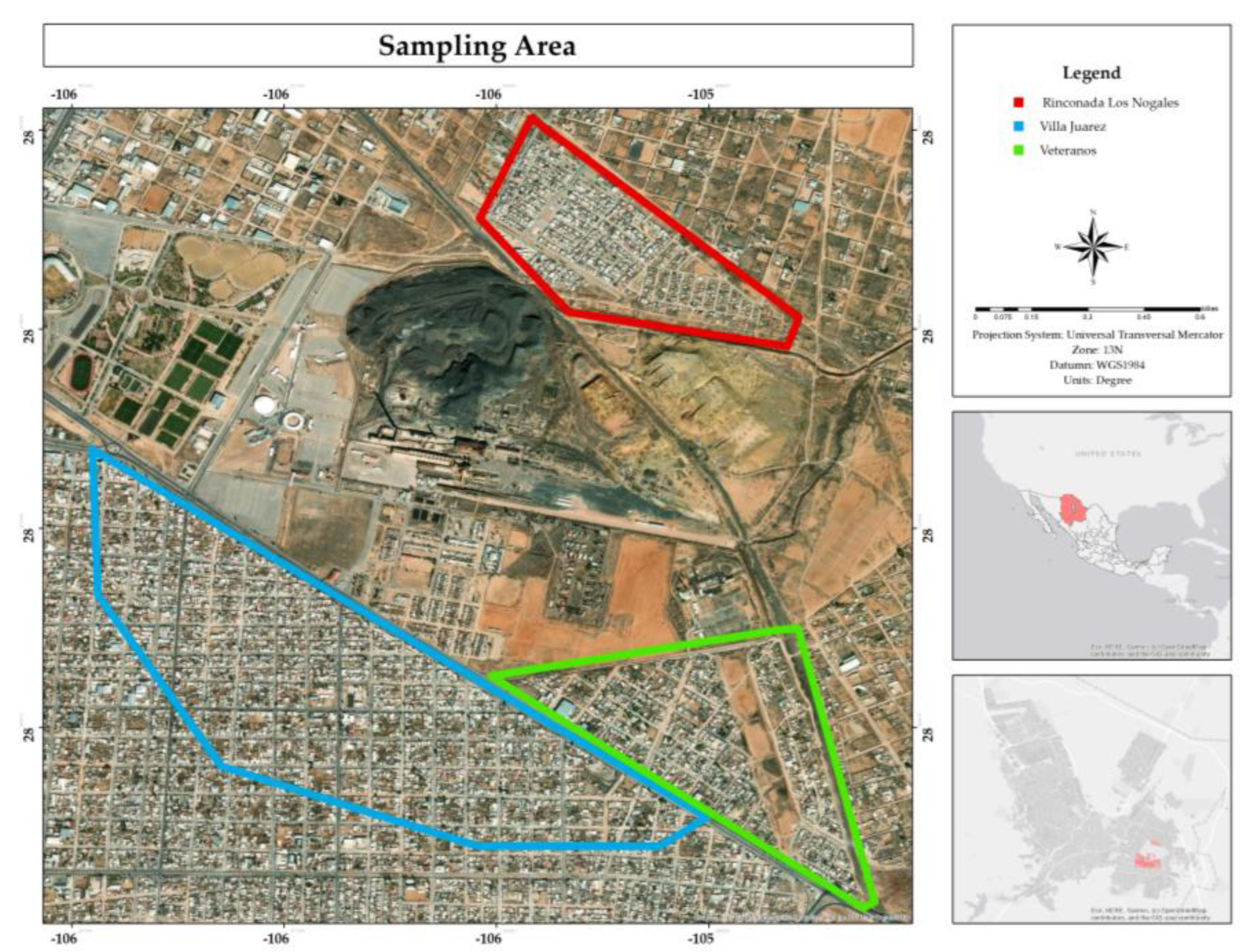
Figure 2.
Percentage of educational level of respondents in the residential area surrounding the former Ávalos foundry.
Figure 2.
Percentage of educational level of respondents in the residential area surrounding the former Ávalos foundry.
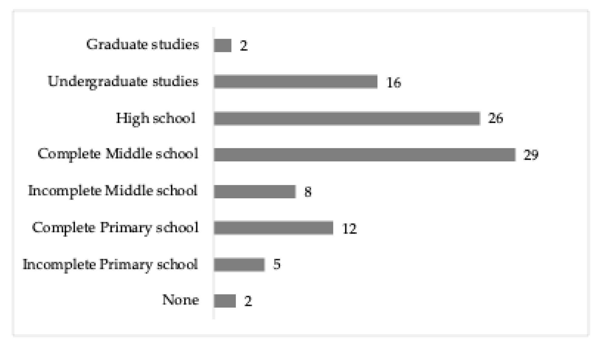
Figure 3.
Percentage of employment status of respondents in the residential area surrounding the former Ávalos foundry.
Figure 3.
Percentage of employment status of respondents in the residential area surrounding the former Ávalos foundry.
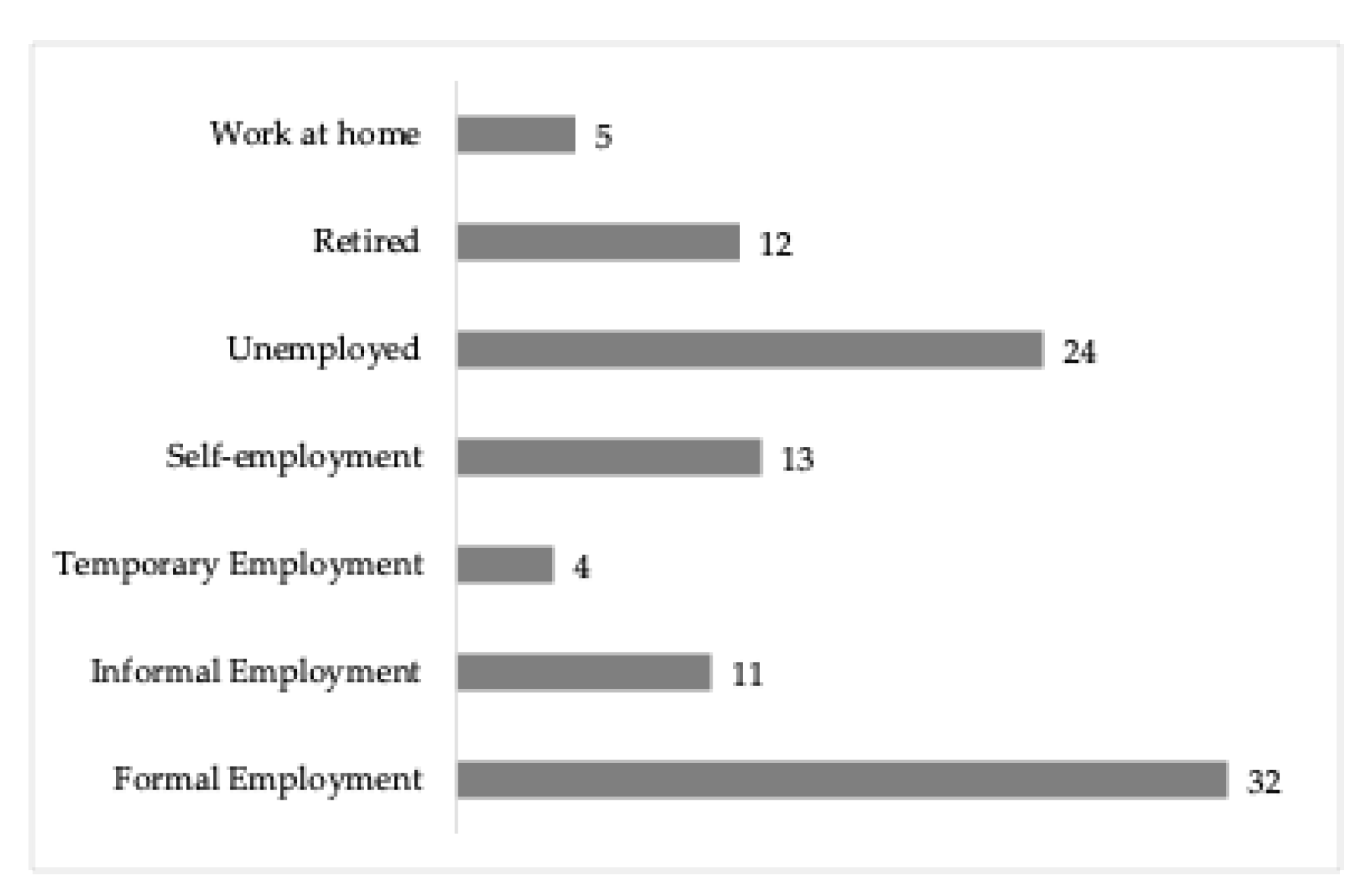
Figure 4.
Percentage of adults aged 20 to 60, and 60 years and older per dwelling in the residential area surrounding the former Ávalos foundry.
Figure 4.
Percentage of adults aged 20 to 60, and 60 years and older per dwelling in the residential area surrounding the former Ávalos foundry.
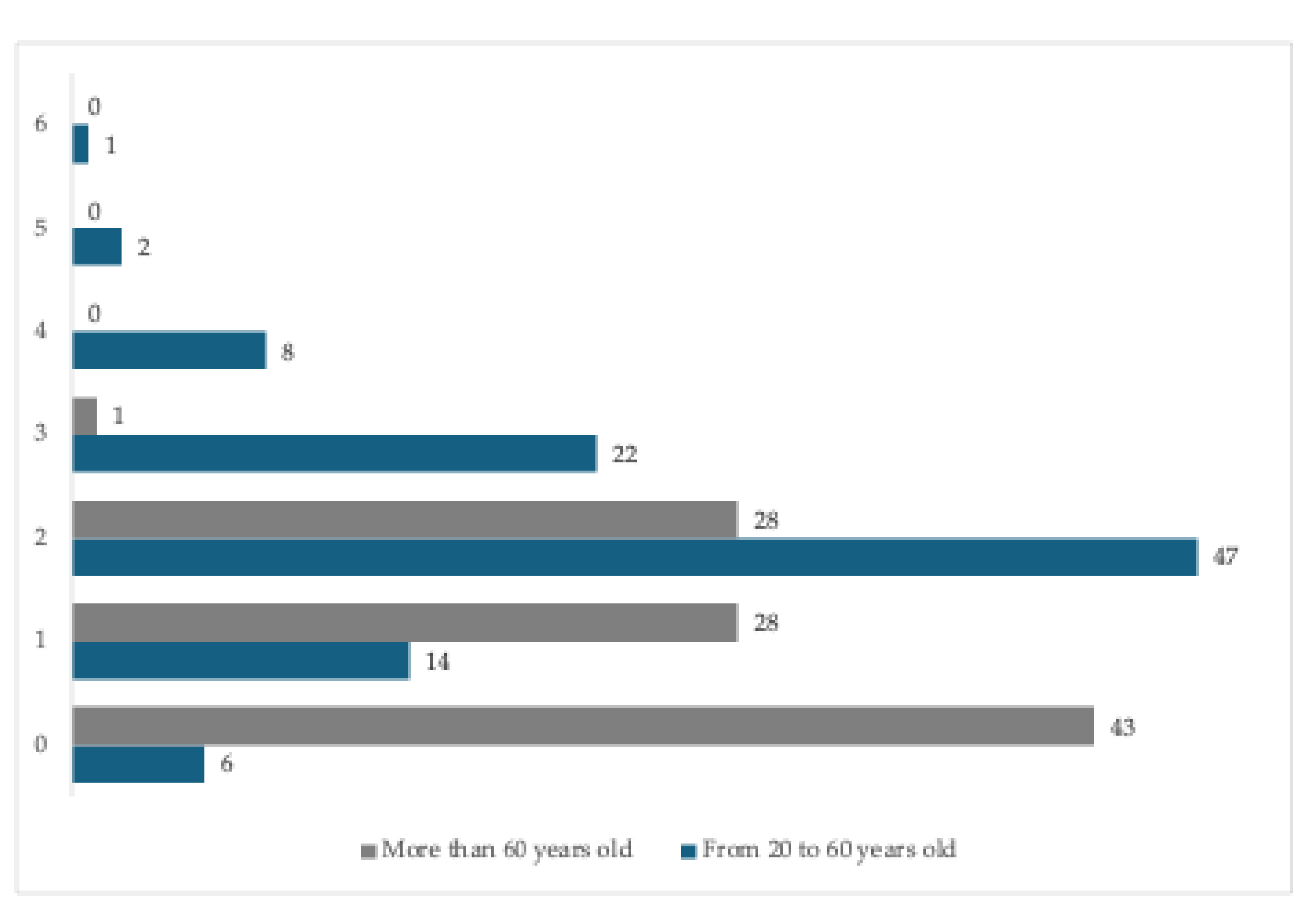
Figure 5.
Percentage of children per dwelling in the residential area surrounding the former Ávalos foundry.
Figure 5.
Percentage of children per dwelling in the residential area surrounding the former Ávalos foundry.
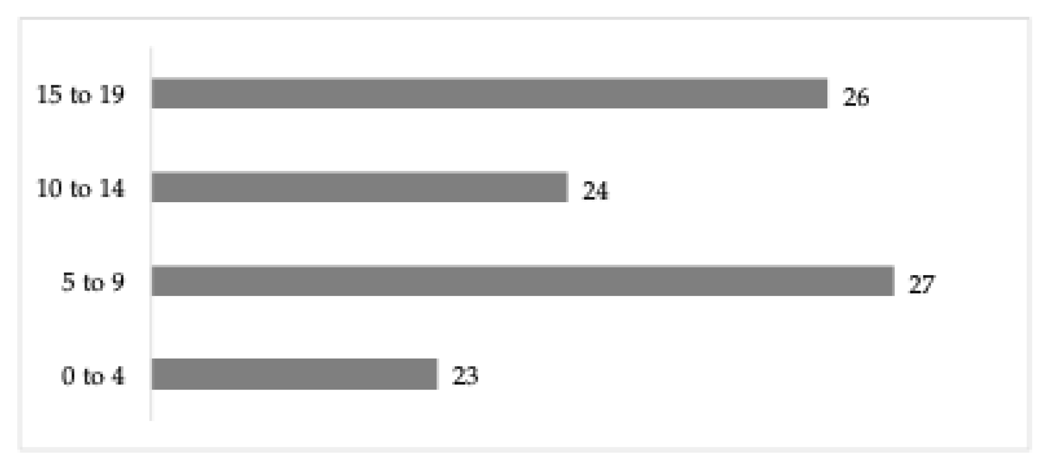
Figure 6.
Percentage and spatial distribution of years living in the residential area surrounding the former Ávalos foundry.
Figure 6.
Percentage and spatial distribution of years living in the residential area surrounding the former Ávalos foundry.
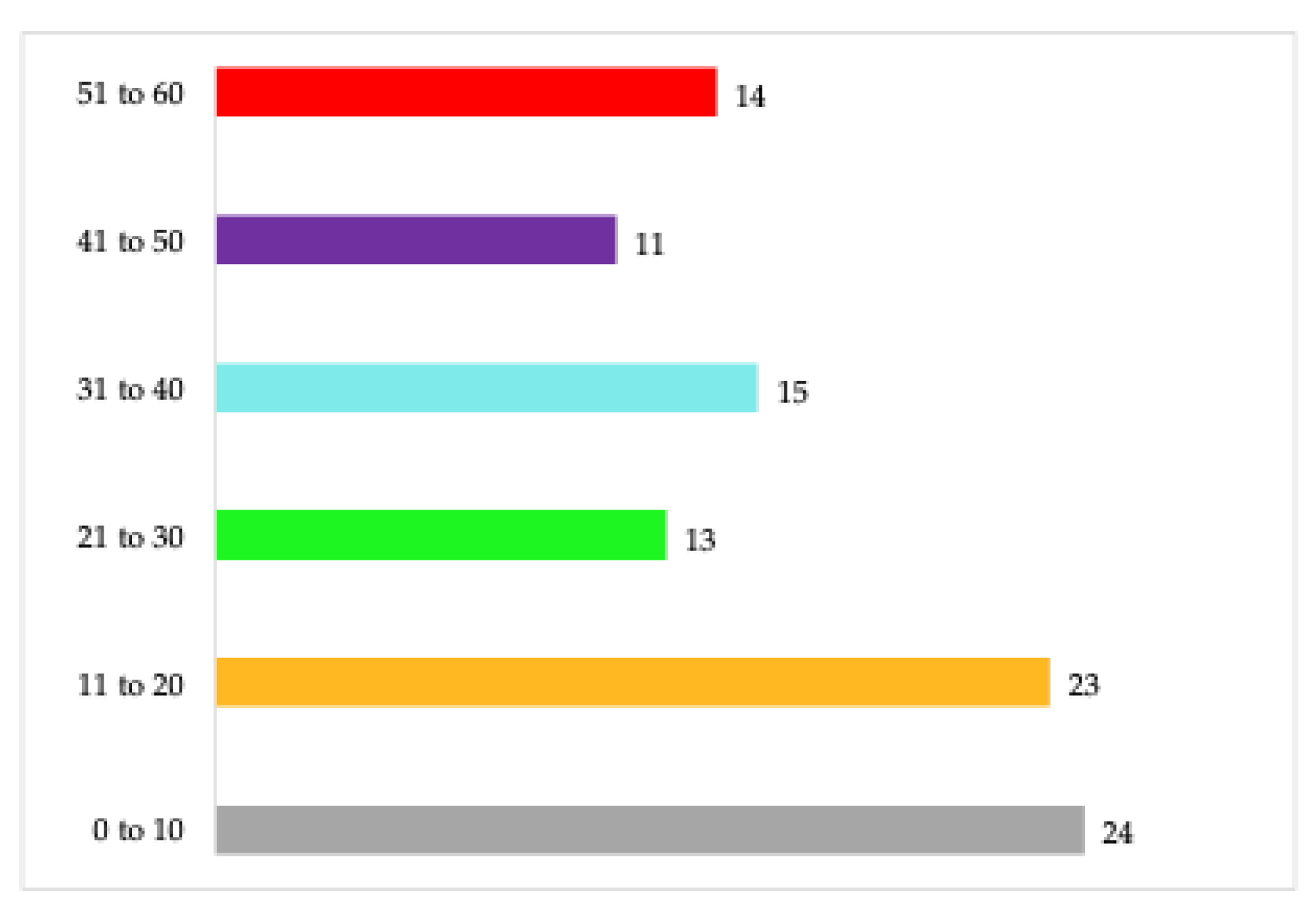
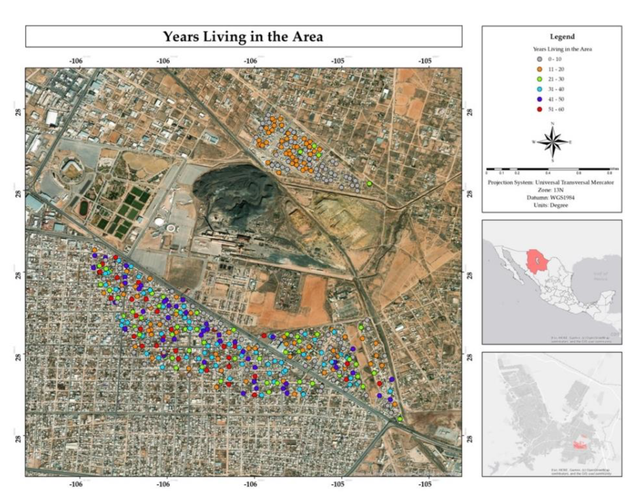
Figure 7.
Percentage and spatial distribution of the reason for residing in the residential area surrounding the former Ávalos foundry.
Figure 7.
Percentage and spatial distribution of the reason for residing in the residential area surrounding the former Ávalos foundry.
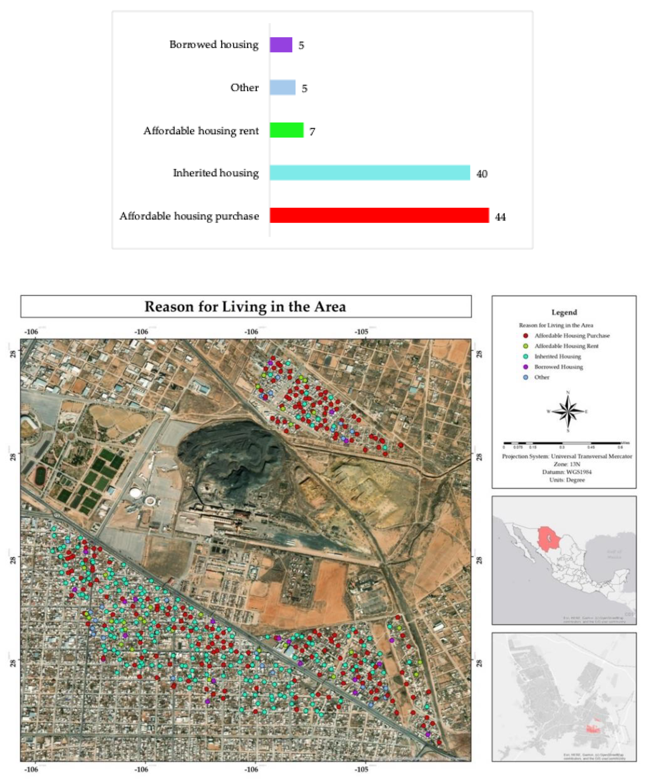
Figure 8.
Percentage and spatial distribution of the comfort degree of living in the residential area adjacent to the former Ávalos foundry.
Figure 8.
Percentage and spatial distribution of the comfort degree of living in the residential area adjacent to the former Ávalos foundry.
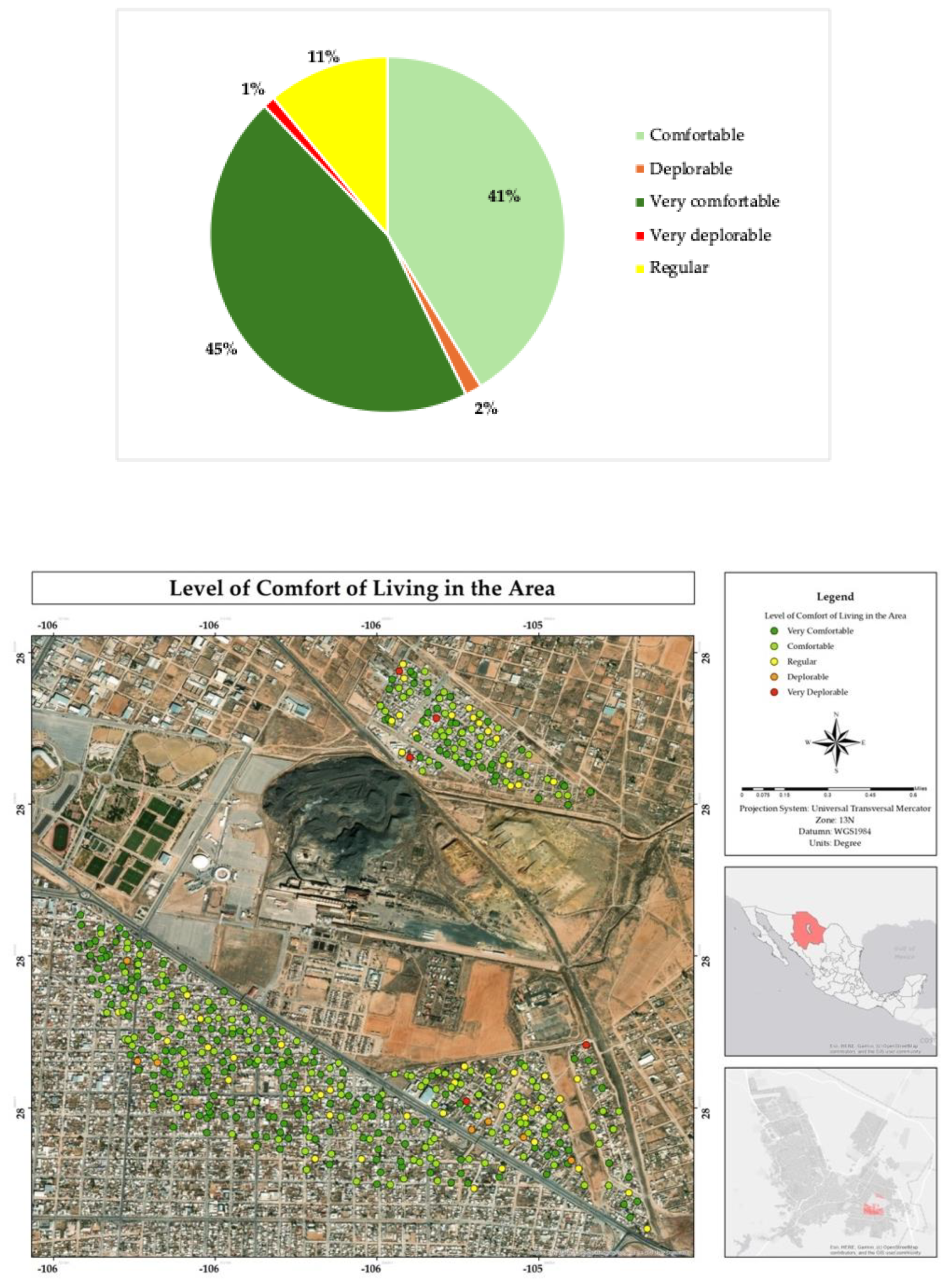
Figure 9.
Spatial distribution of knowledge about the negative health effects in the residential area surrounding the former Ávalos foundry.
Figure 9.
Spatial distribution of knowledge about the negative health effects in the residential area surrounding the former Ávalos foundry.
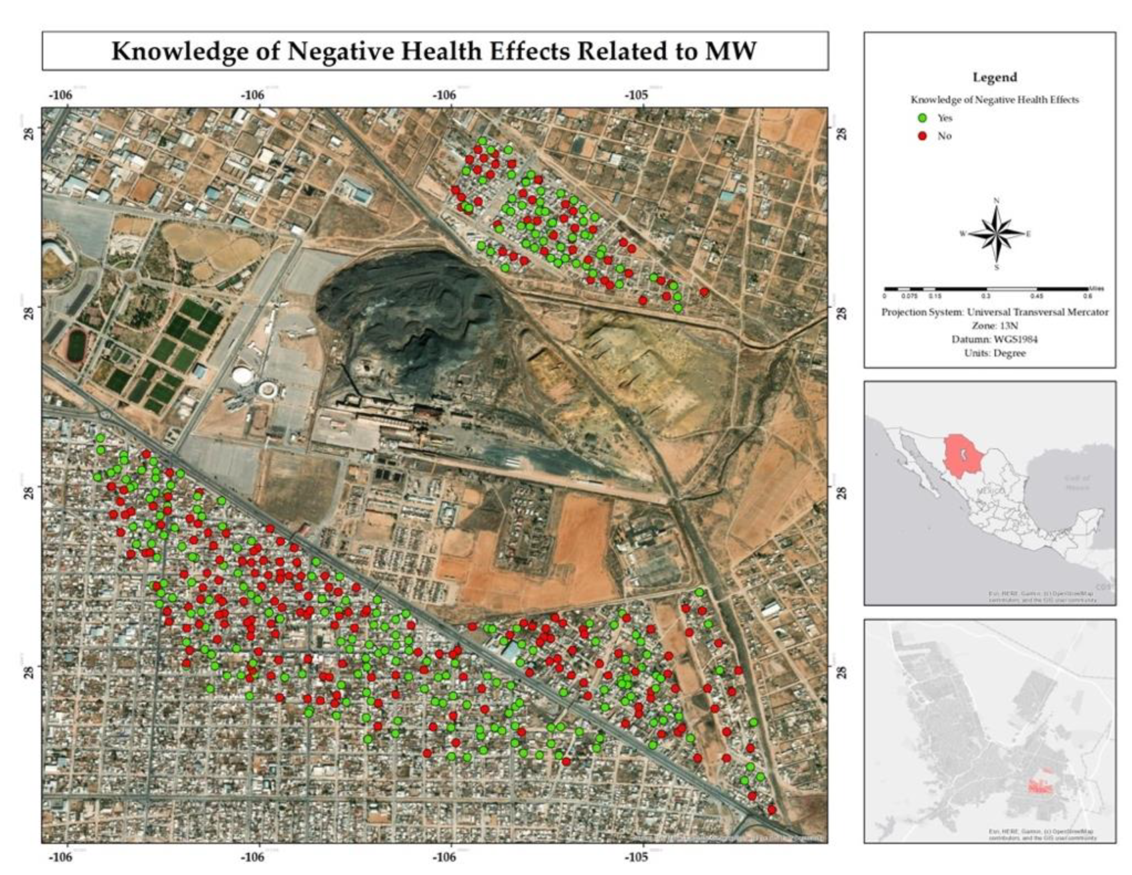
Figure 10.
Spatial distribution of the decision to live in the area, even knowing the risks to be adjacent to the former Ávalos smelter.
Figure 10.
Spatial distribution of the decision to live in the area, even knowing the risks to be adjacent to the former Ávalos smelter.
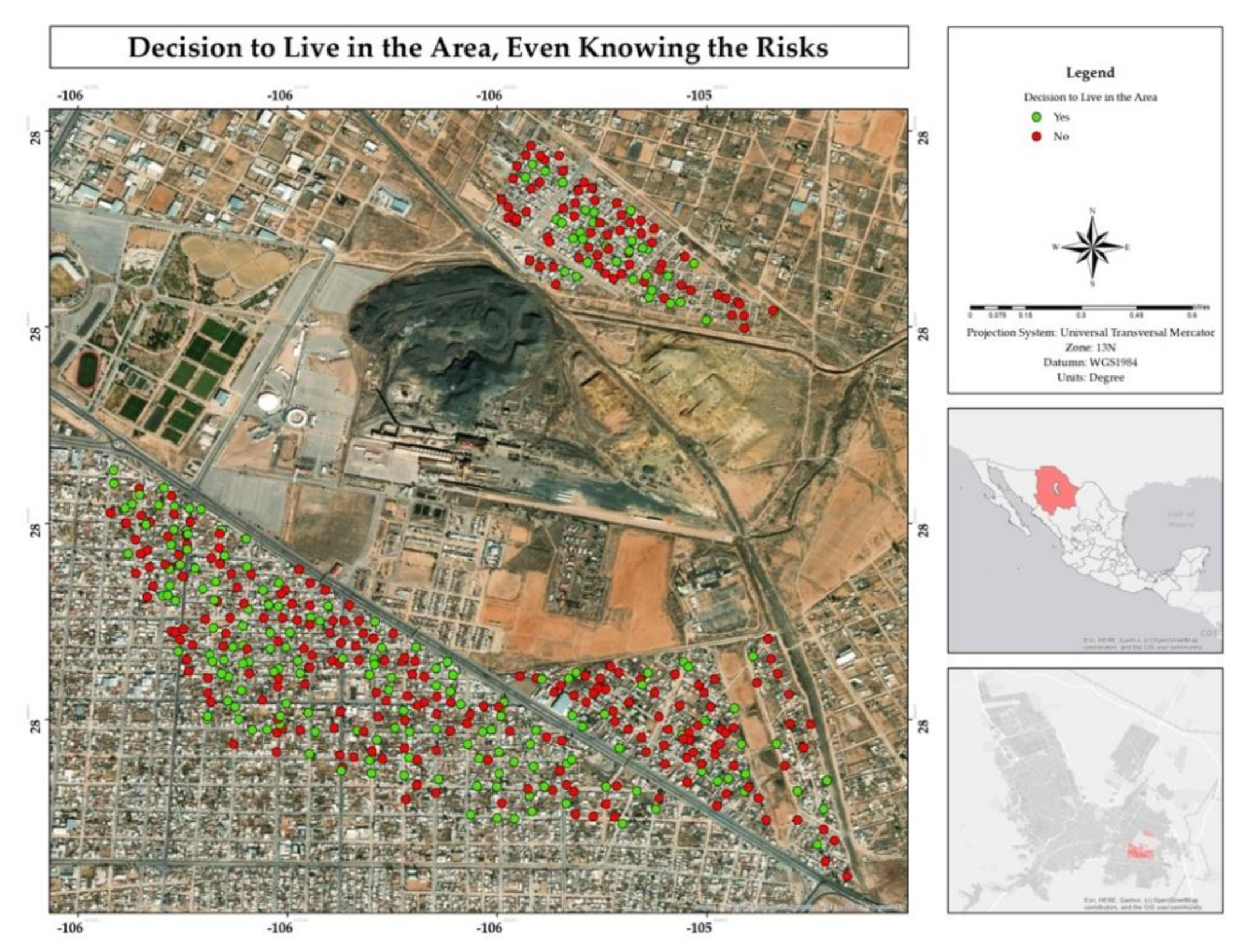
Figure 11.
Percentage of water consumption source in the residential area surrounding the former Ávalos foundry.
Figure 11.
Percentage of water consumption source in the residential area surrounding the former Ávalos foundry.
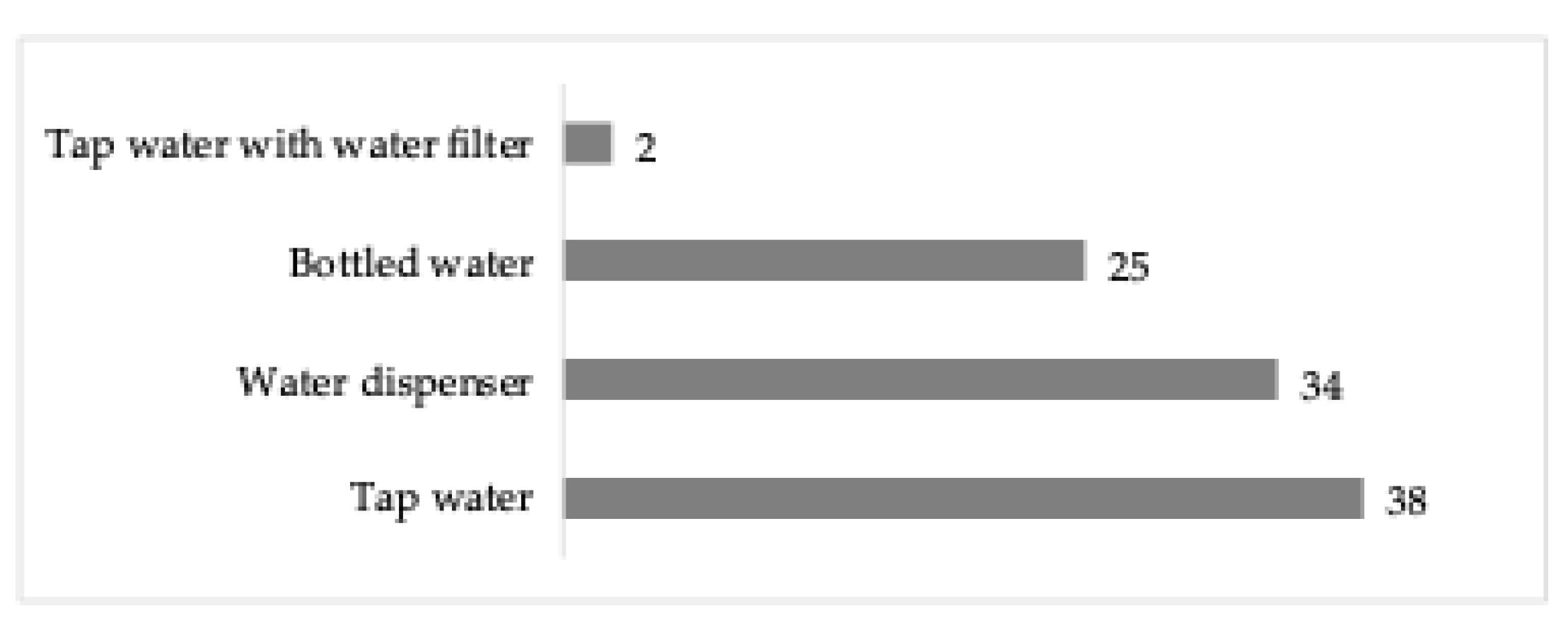
Figure 12.
Percentage and spatial distribution of the symptoms or illnesses perception of respondents or family members who live in their homes in the residential area adjacent to the former Ávalos foundry.
Figure 12.
Percentage and spatial distribution of the symptoms or illnesses perception of respondents or family members who live in their homes in the residential area adjacent to the former Ávalos foundry.
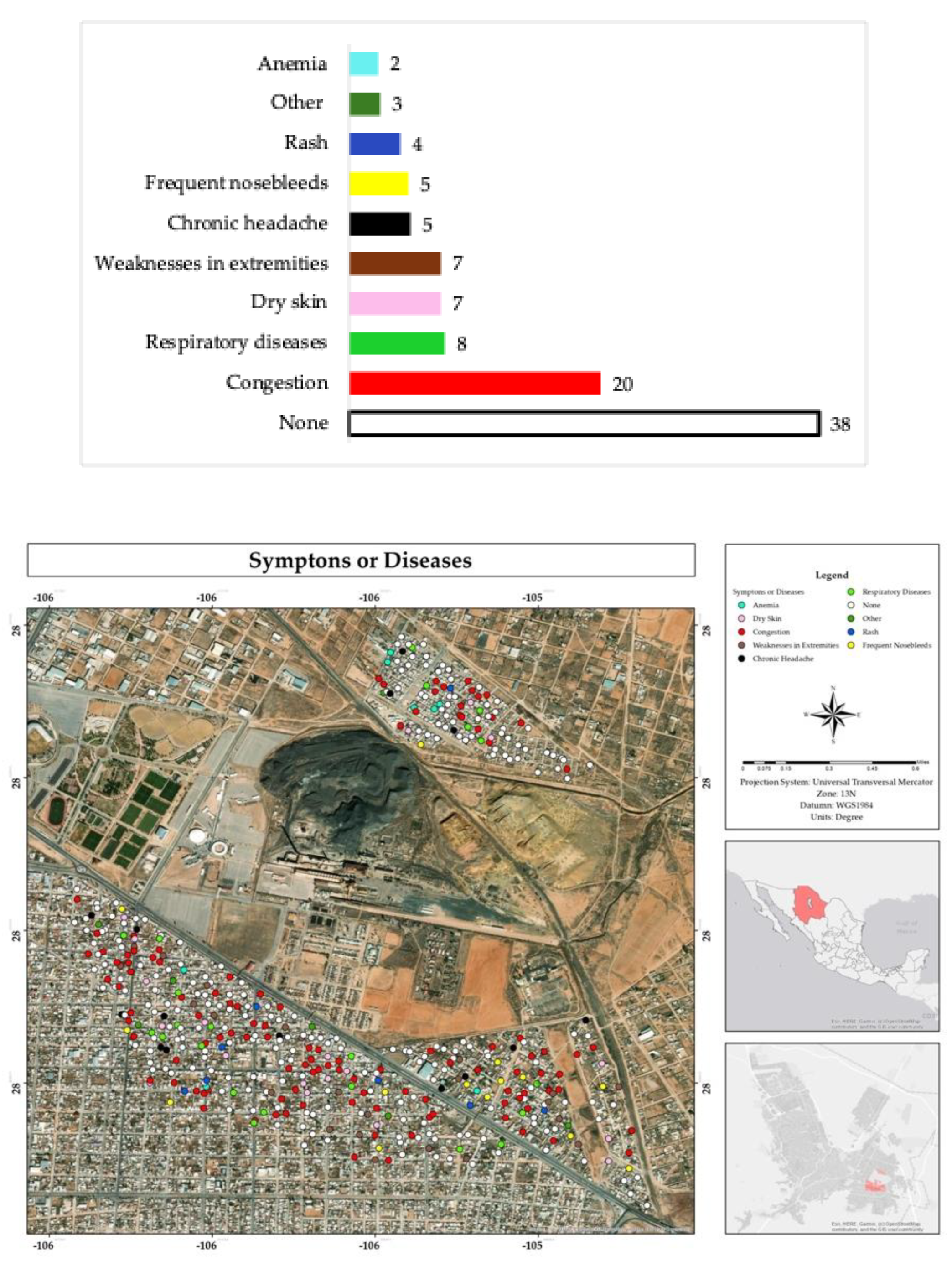
Figure 13.
Percentage and spatial distribution of diseases diagnosed in respondents or family members residing in their homes in the residential area adjacent to the former Ávalos foundry.
Figure 13.
Percentage and spatial distribution of diseases diagnosed in respondents or family members residing in their homes in the residential area adjacent to the former Ávalos foundry.
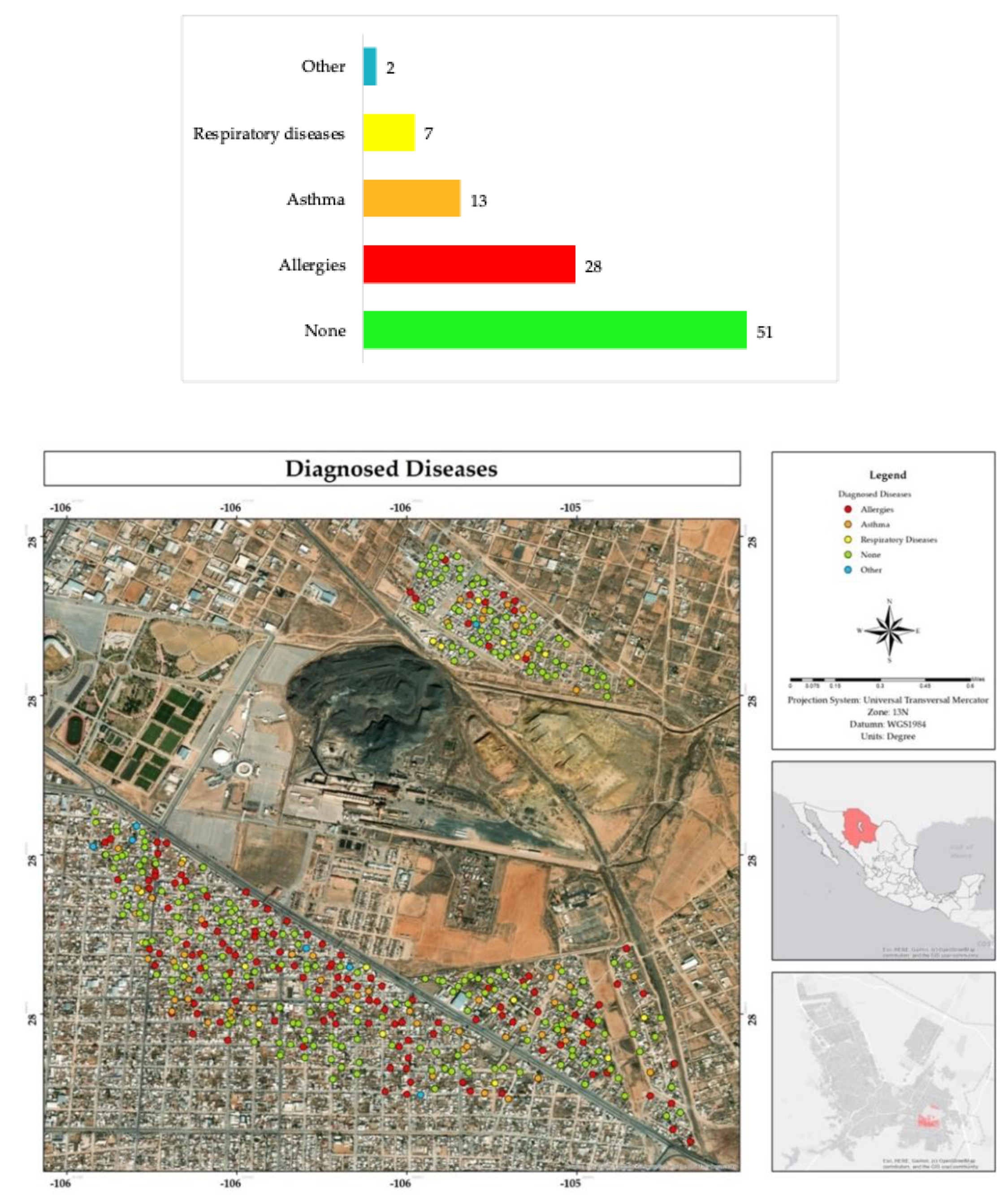
Figure 14.
Percentage and spatial distribution of knowledge about chronic diseases suffered by neighbors of the respondents in the residential area adjacent to the former Ávalos foundry.
Figure 14.
Percentage and spatial distribution of knowledge about chronic diseases suffered by neighbors of the respondents in the residential area adjacent to the former Ávalos foundry.
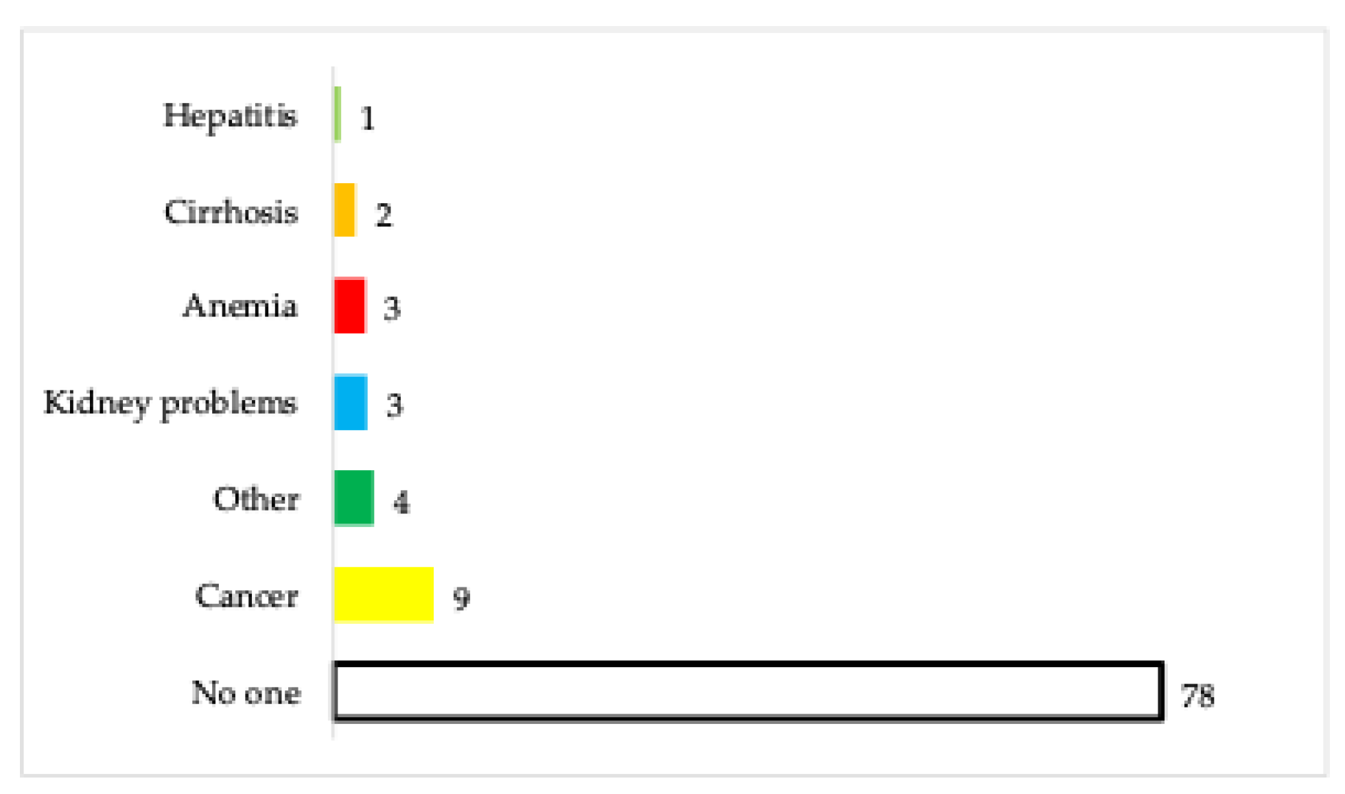
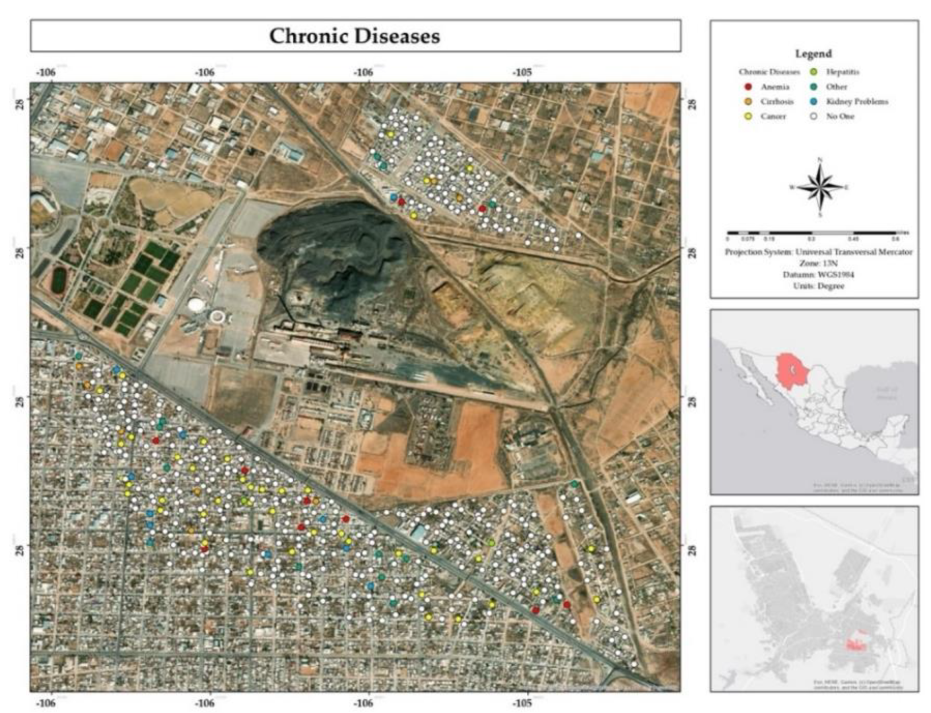
Figure 15.
Percentage and spatial distribution of knowledge about genetic conditions suffered by neighbors of the respondents in the residential area adjacent to the former Ávalos foundry.
Figure 15.
Percentage and spatial distribution of knowledge about genetic conditions suffered by neighbors of the respondents in the residential area adjacent to the former Ávalos foundry.
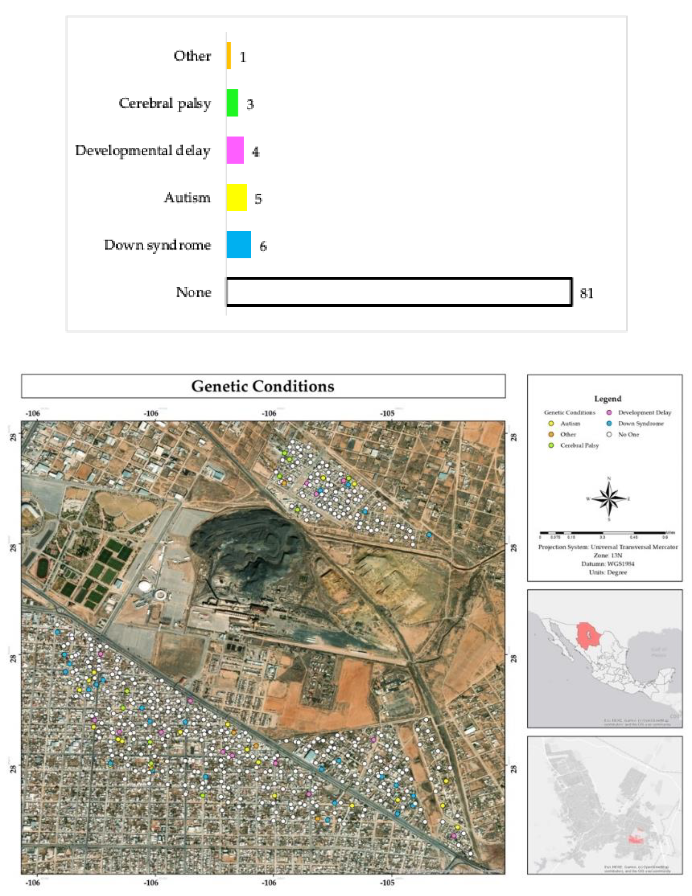
Figure 16.
Percentage and spatial distribution of the perception of cognitive or psychological disorders of respondents in the residential area surrounding the former Ávalos foundry.
Figure 16.
Percentage and spatial distribution of the perception of cognitive or psychological disorders of respondents in the residential area surrounding the former Ávalos foundry.
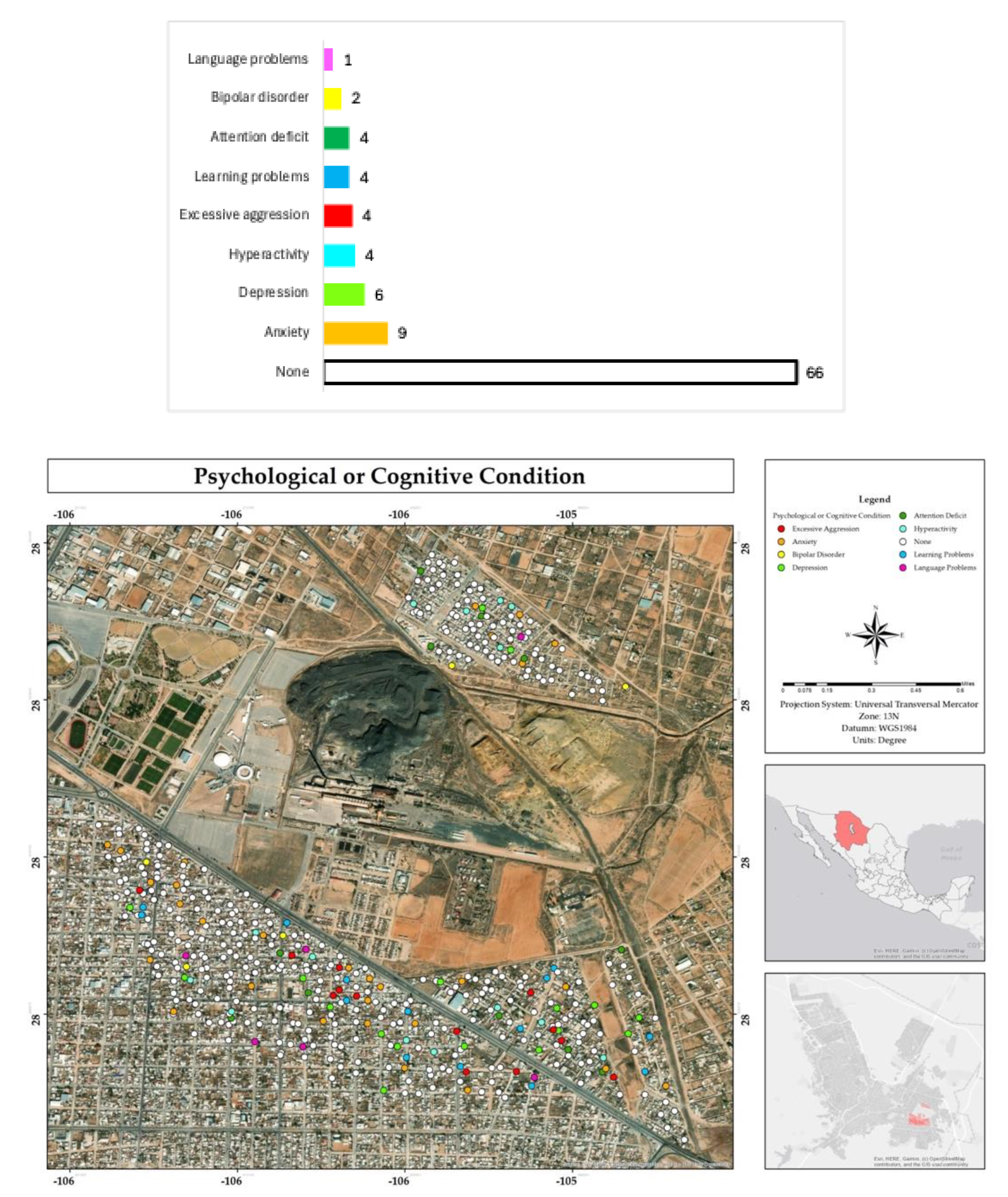
Figure 17.
Percentage and spatial distribution of problems faced by respondents in the residential area surrounding the former Ávalos foundry.
Figure 17.
Percentage and spatial distribution of problems faced by respondents in the residential area surrounding the former Ávalos foundry.
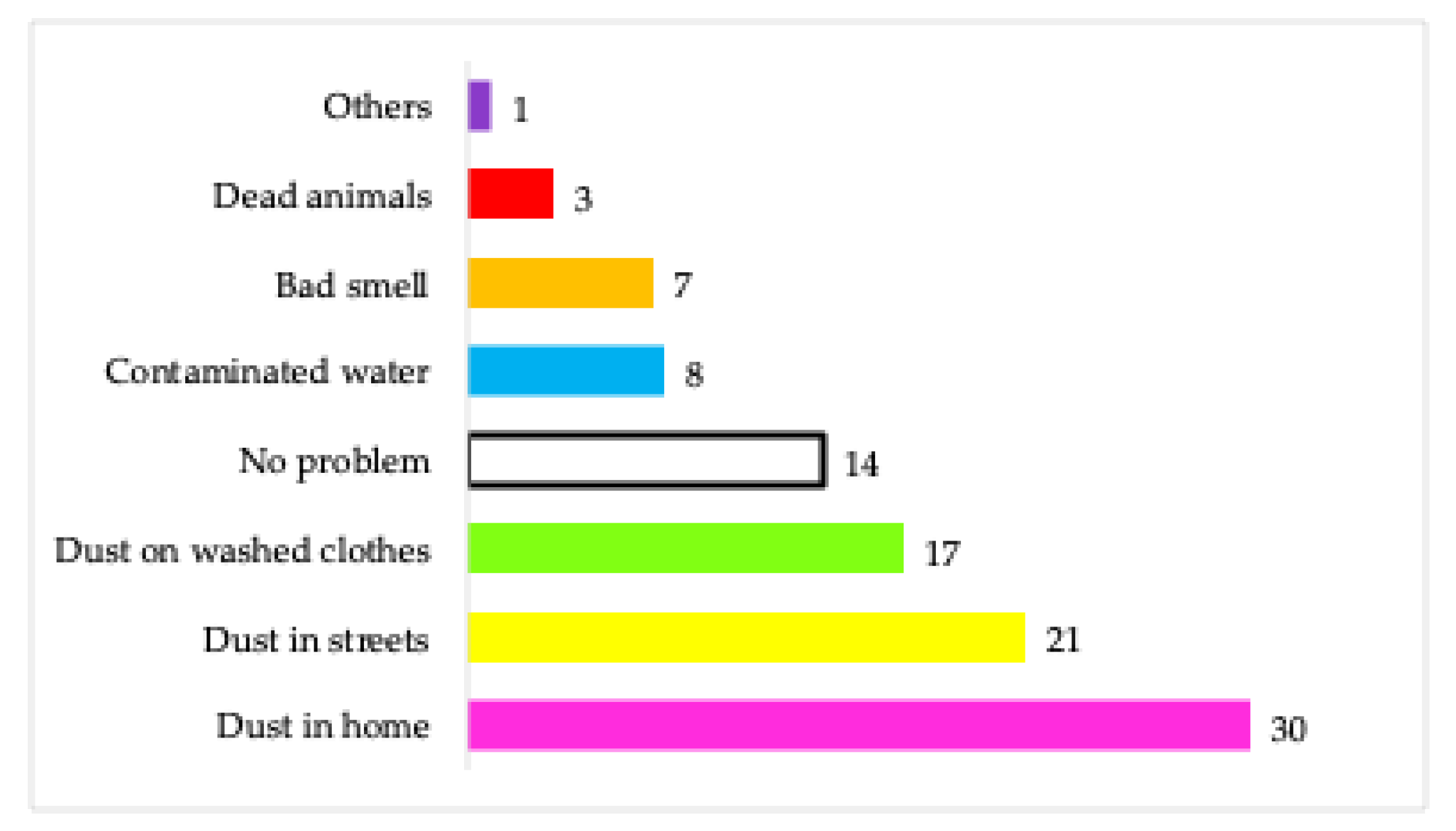
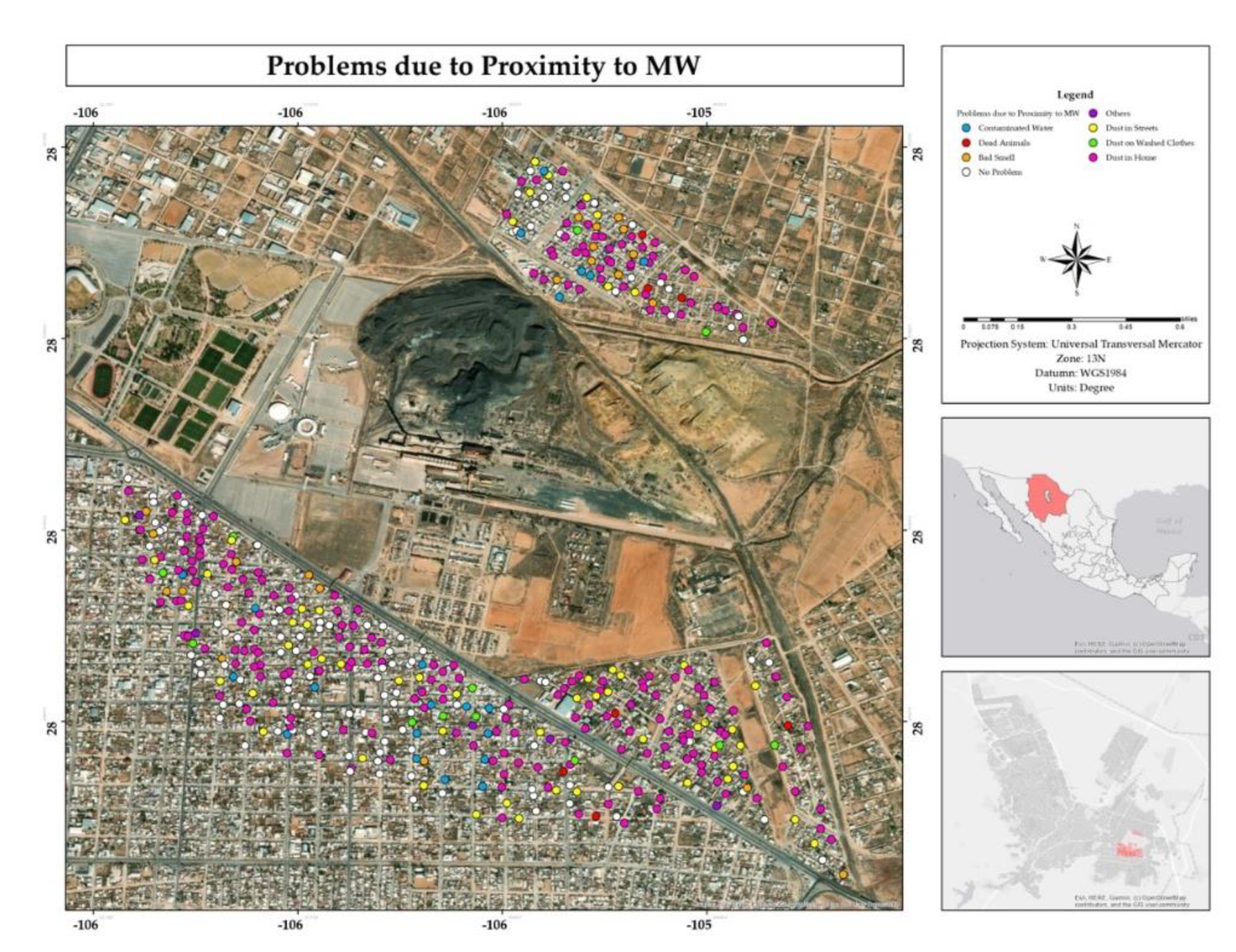
Figure 18.
Percentage of actions taken to mitigate the impacts by inhabitants of the residential area surrounding the former Ávalos foundry.
Figure 18.
Percentage of actions taken to mitigate the impacts by inhabitants of the residential area surrounding the former Ávalos foundry.
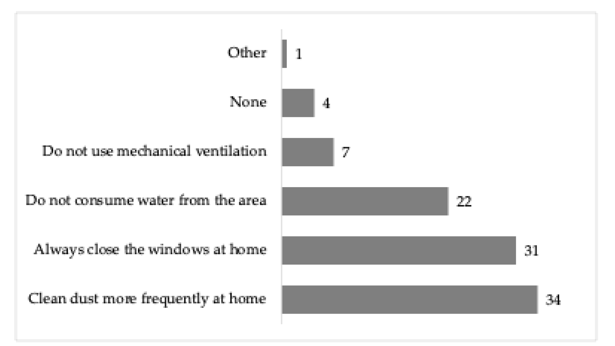
Figure 19.
Spatial distribution of the choice of house change if have opportunity from the residential area surrounding the former Ávalos foundry.
Figure 19.
Spatial distribution of the choice of house change if have opportunity from the residential area surrounding the former Ávalos foundry.
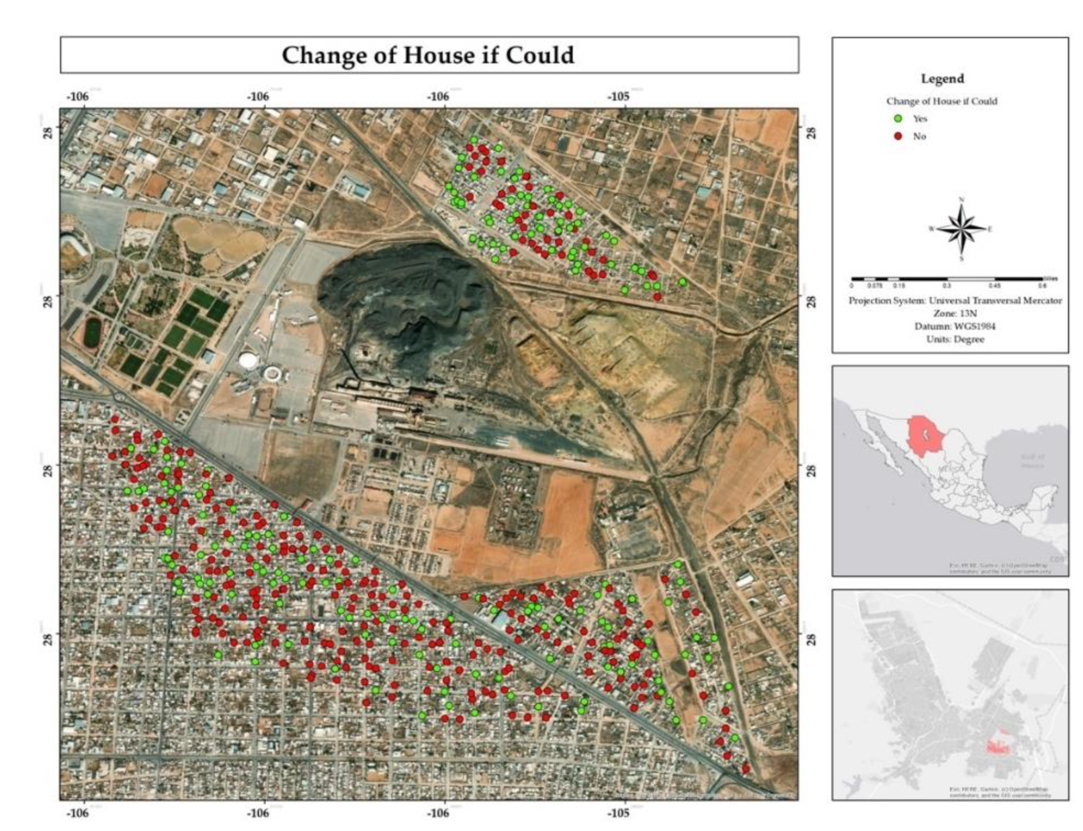
Figure 20.
Percentage of residents in the residential area surrounding the former Ávalos foundry choosing to change their home if they had the opportunity, per neighborhood.
Figure 20.
Percentage of residents in the residential area surrounding the former Ávalos foundry choosing to change their home if they had the opportunity, per neighborhood.
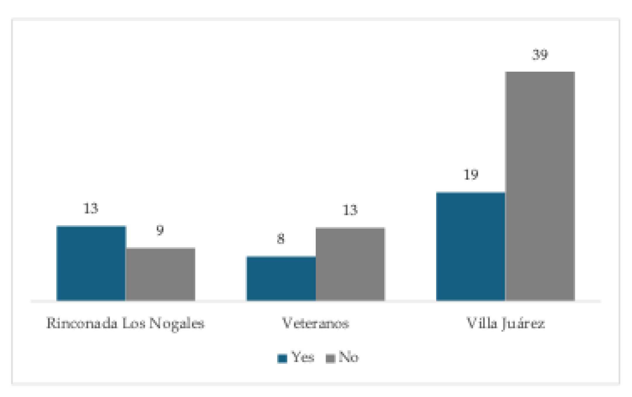
Figure 21.
Spatial distribution of knowledge about health campaigns by public administration in the residential area surrounding the former Ávalos foundry.
Figure 21.
Spatial distribution of knowledge about health campaigns by public administration in the residential area surrounding the former Ávalos foundry.
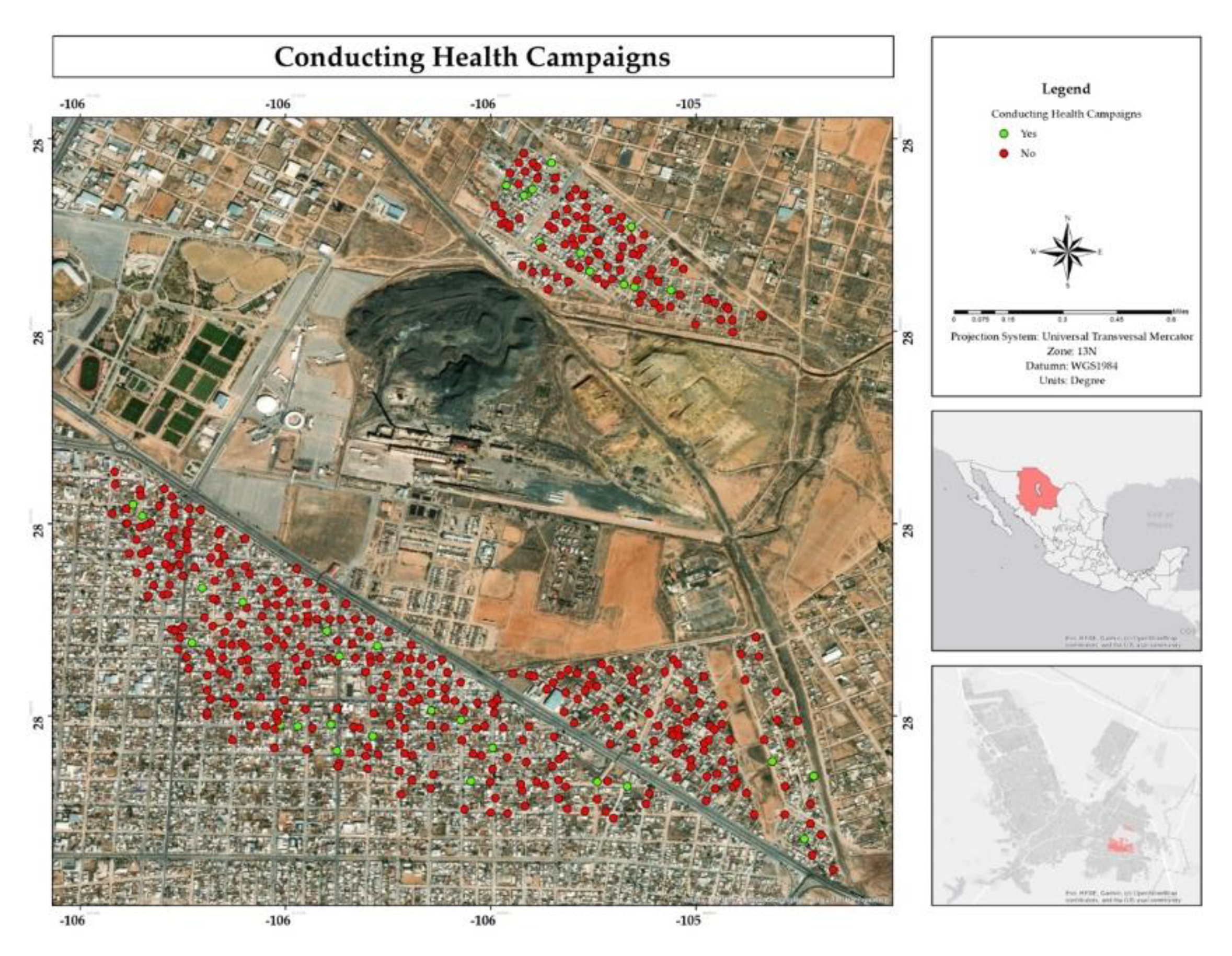
Figure 22.
Spatial distribution of possible relocation by the public administration for residents of the residential area adjacent to the former Ávalos foundry.
Figure 22.
Spatial distribution of possible relocation by the public administration for residents of the residential area adjacent to the former Ávalos foundry.
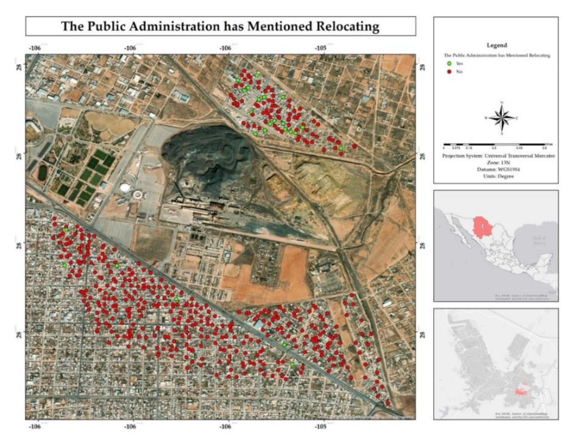
Figure 23.
Percentage of possible relocation by public administration for inhabitants of the residential area surrounding the former Ávalos foundry by neighborhood.
Figure 23.
Percentage of possible relocation by public administration for inhabitants of the residential area surrounding the former Ávalos foundry by neighborhood.
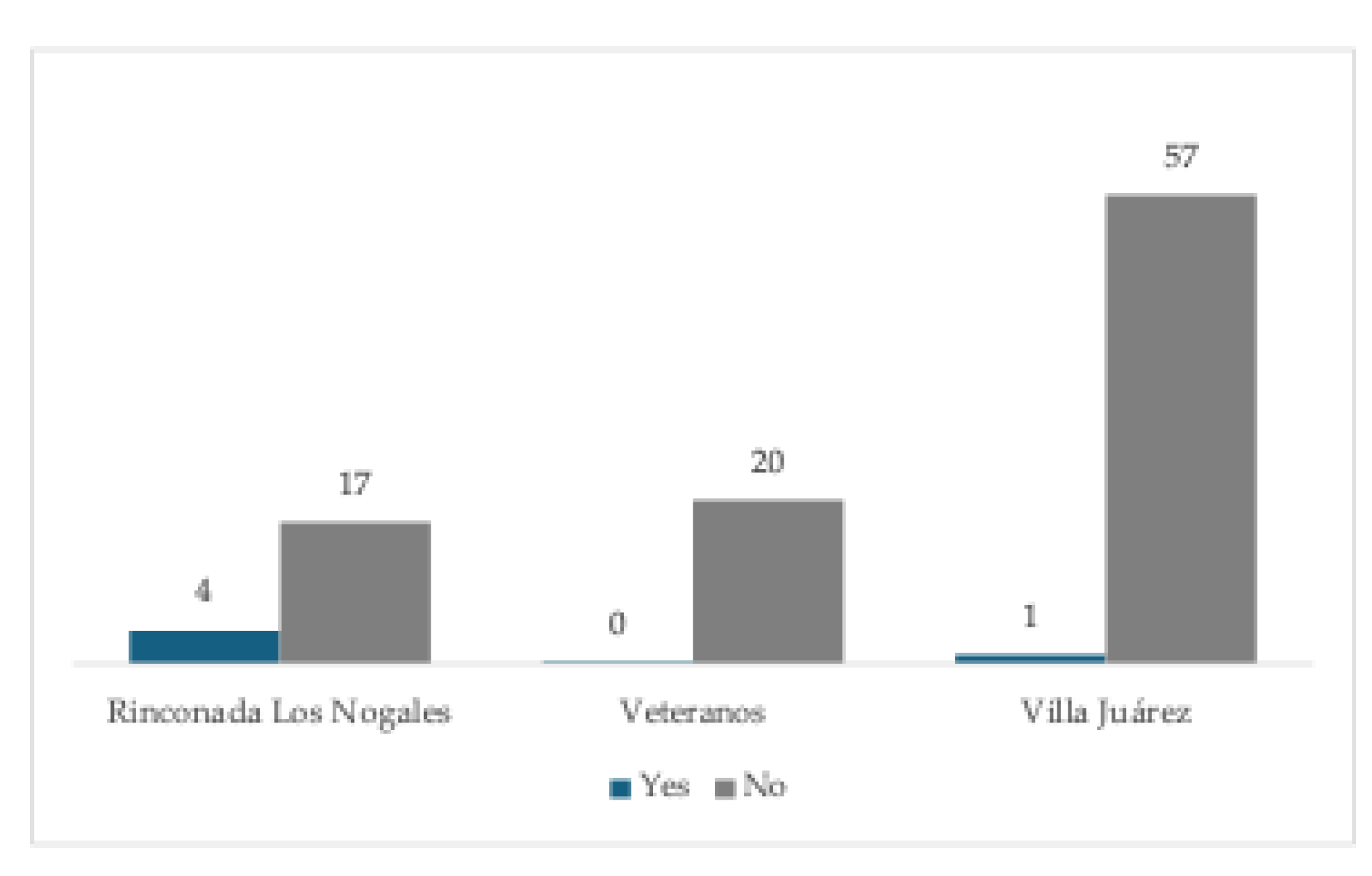
Figure 24.
Percentage of requests to public administration from respondents in the residential area surrounding the former Ávalos foundry.
Figure 24.
Percentage of requests to public administration from respondents in the residential area surrounding the former Ávalos foundry.
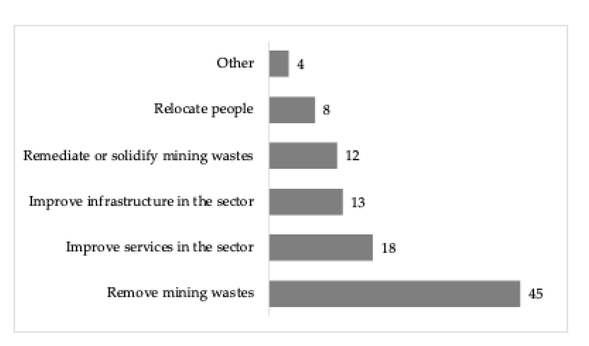
Figure 25.
Spatial distribution of blood lead testing among respondents in the residential area surrounding the former Ávalos foundry.
Figure 25.
Spatial distribution of blood lead testing among respondents in the residential area surrounding the former Ávalos foundry.
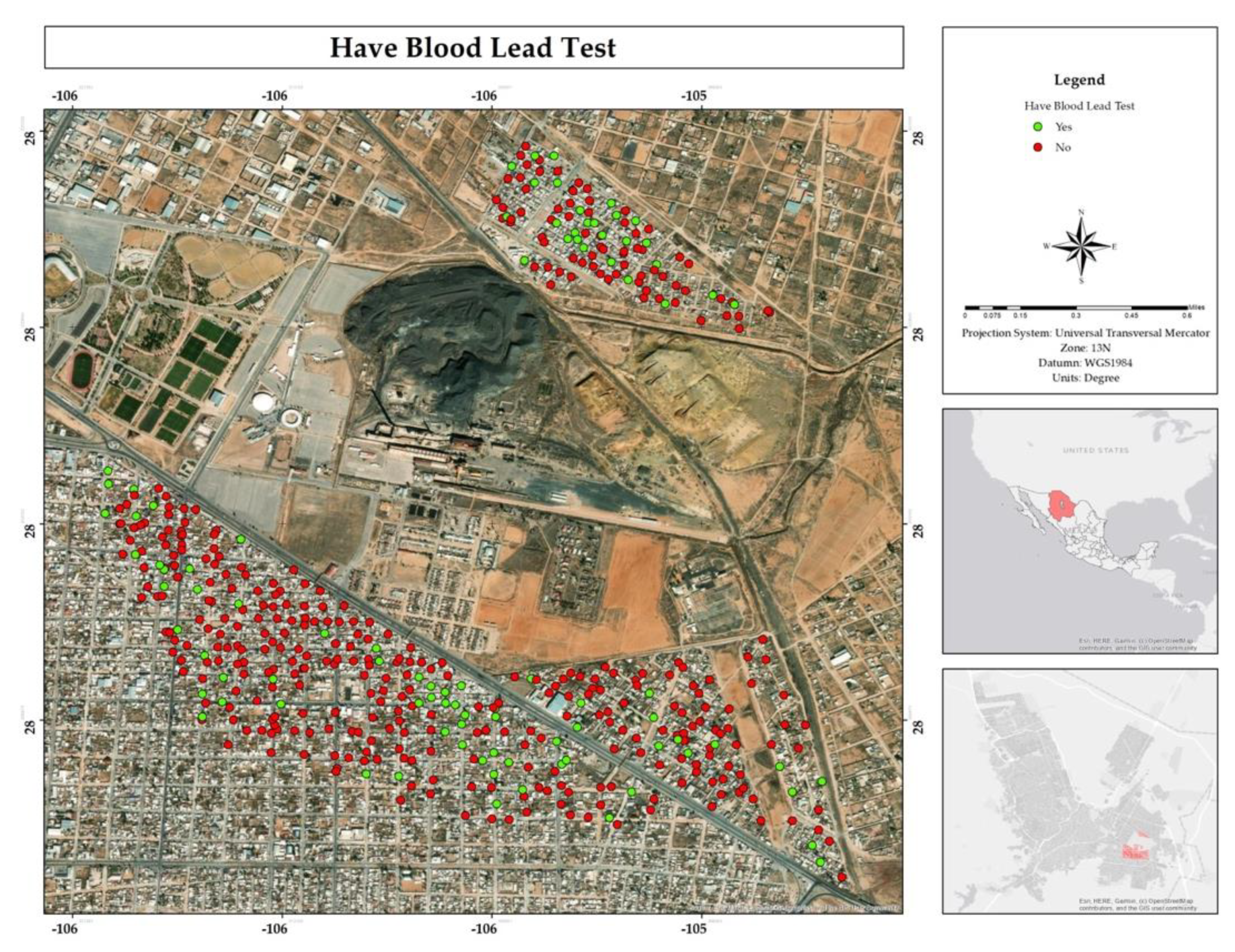
Figure 26.
Spatial distribution of abandonment cases in the neighborhoods where respondents live in the residential area adjacent to the former Ávalos foundry.
Figure 26.
Spatial distribution of abandonment cases in the neighborhoods where respondents live in the residential area adjacent to the former Ávalos foundry.
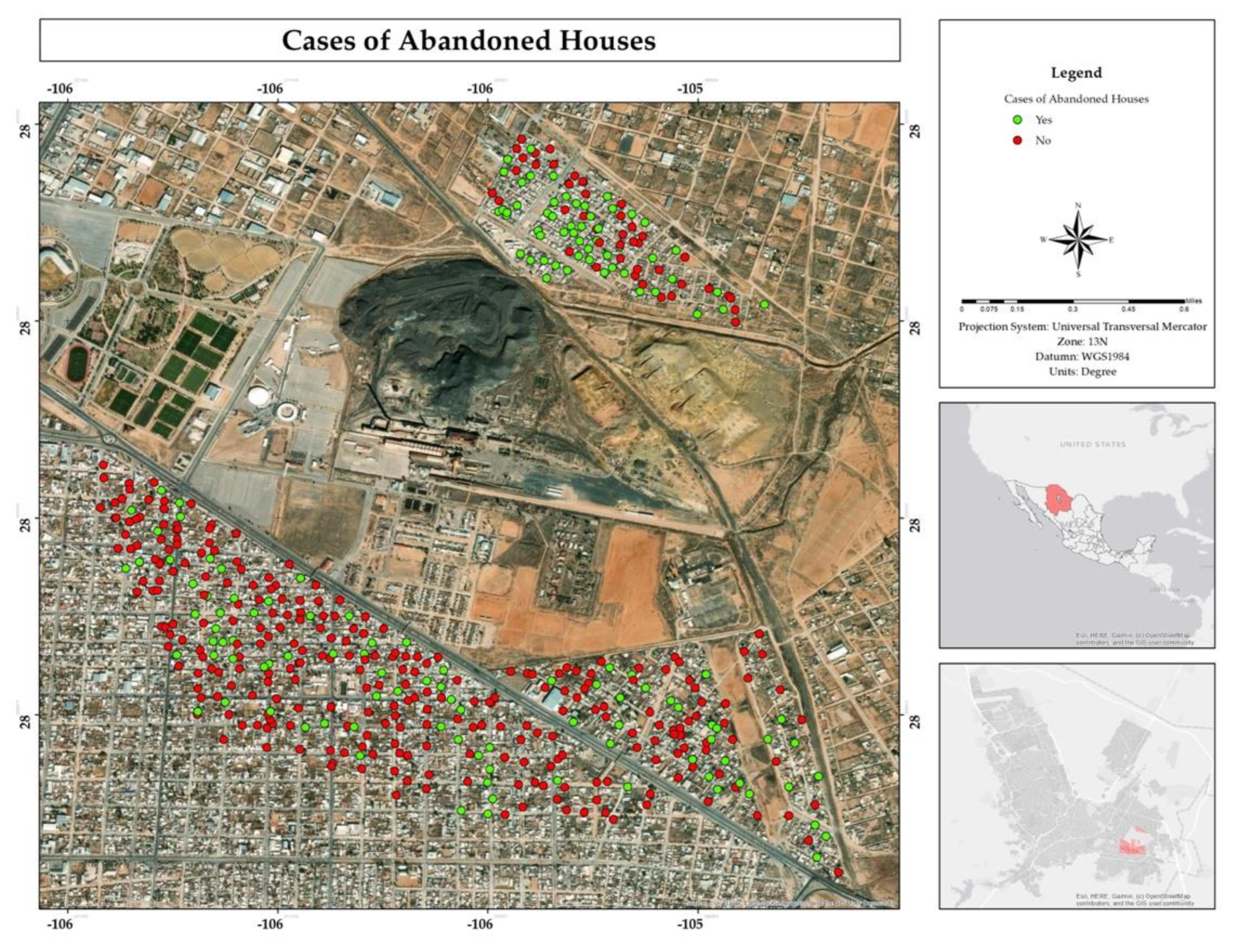
Figure 27.
Percentages of concern about pollution, impact over future generation, participation in community activities, and differences that the community can make to reduce pollution in the residential area surrounding the former Ávalos smelter.
Figure 27.
Percentages of concern about pollution, impact over future generation, participation in community activities, and differences that the community can make to reduce pollution in the residential area surrounding the former Ávalos smelter.
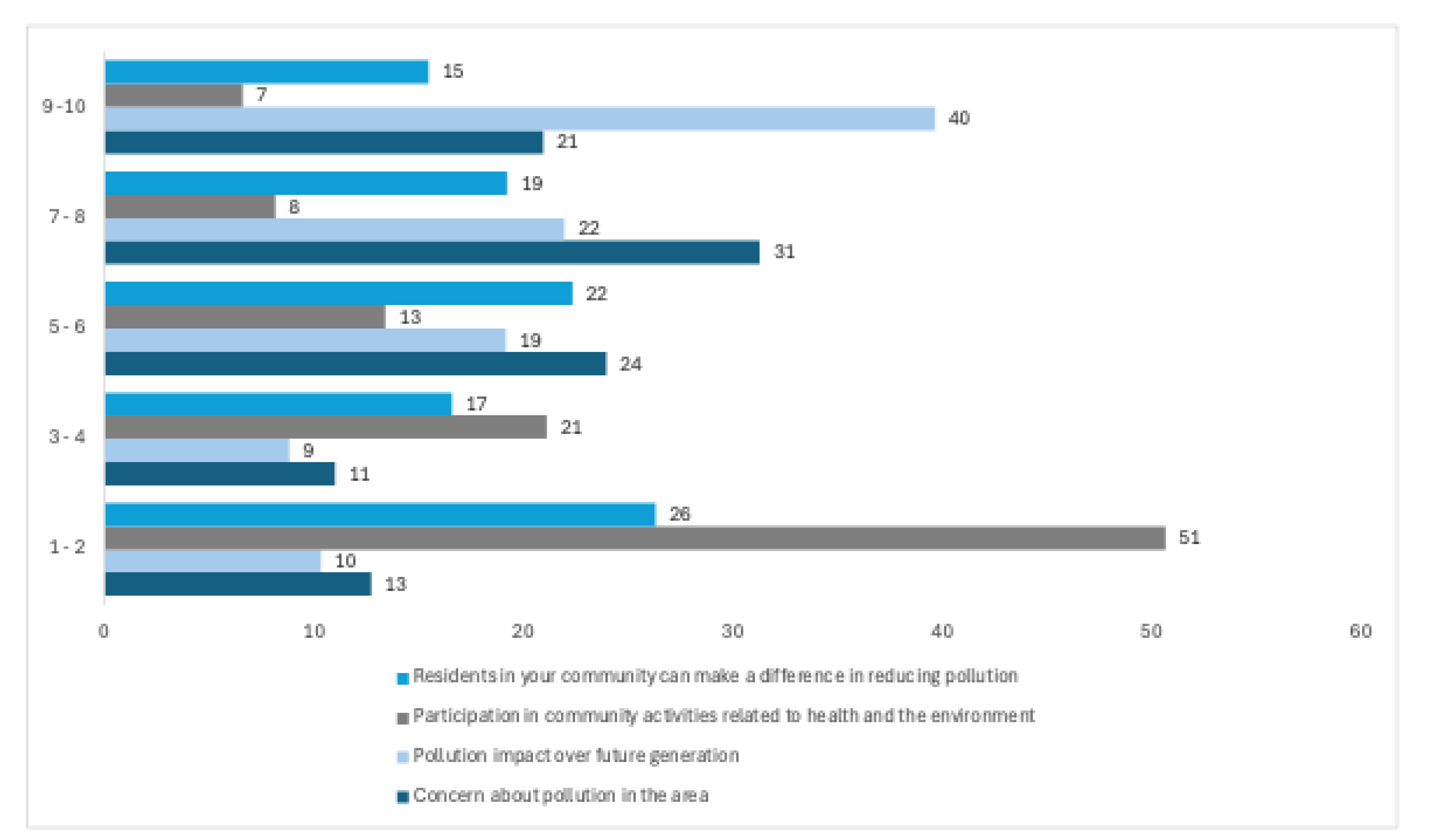
Figure 28.
Spatial distribution of Arsenic in mg/L in water in the residential area of the former Ávalos smelter.
Figure 28.
Spatial distribution of Arsenic in mg/L in water in the residential area of the former Ávalos smelter.
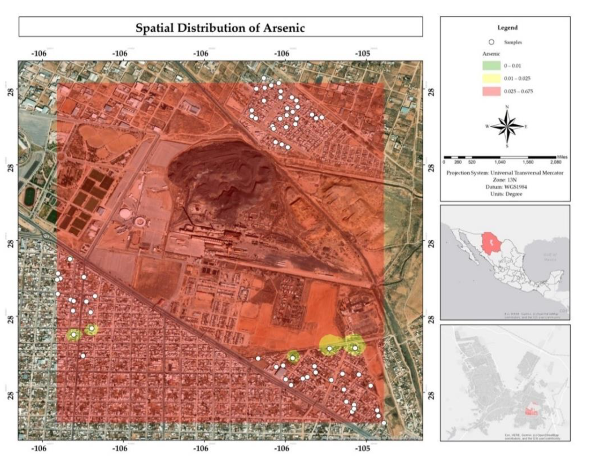
Figure 29.
Spatial distribution of Copper in mg/L in water in the residential area of the Ávalos smelter.
Figure 29.
Spatial distribution of Copper in mg/L in water in the residential area of the Ávalos smelter.
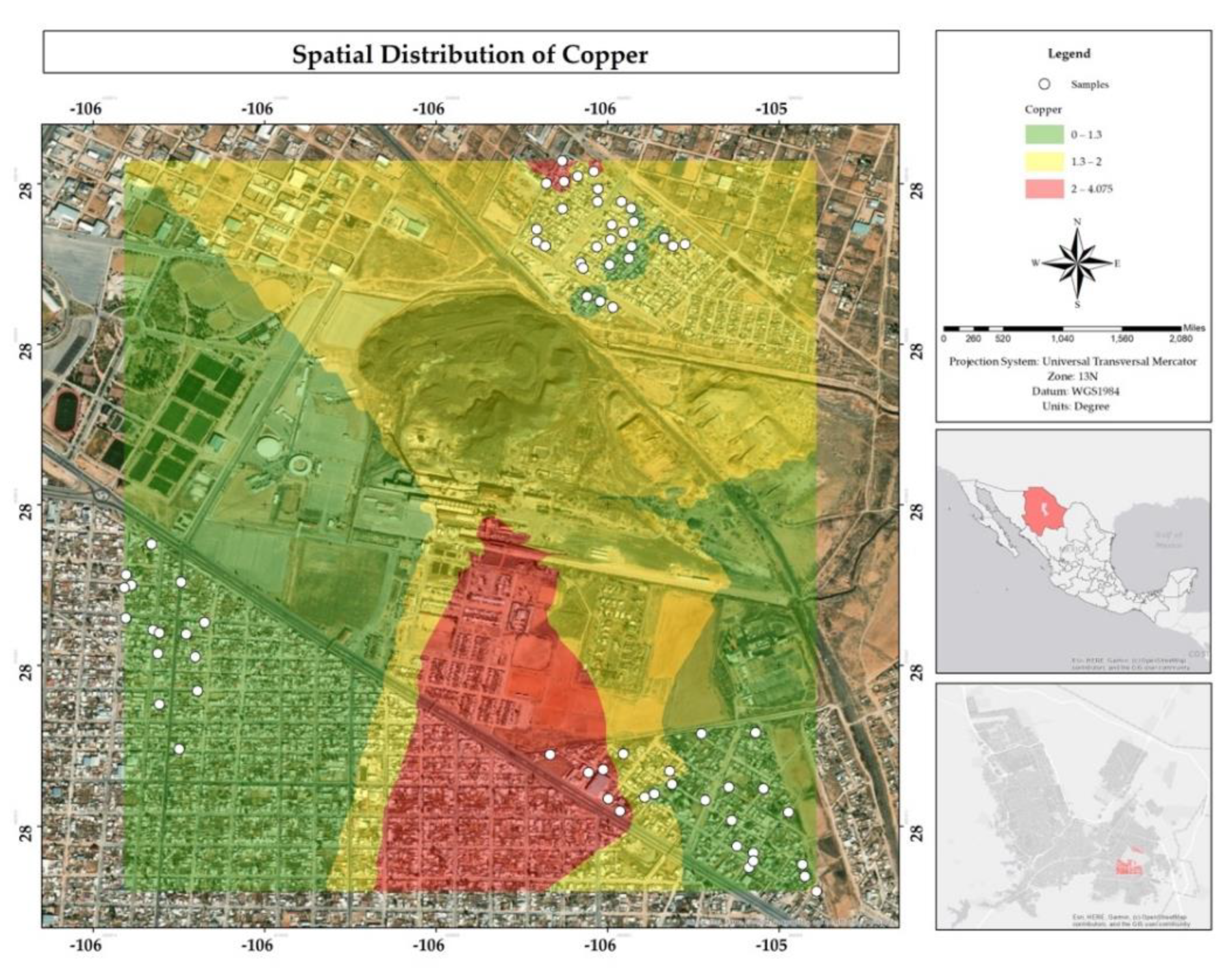
Figure 30.
Spatial distribution of Chromium in mg/L in water in the residential area of the Ávalos smelter.
Figure 30.
Spatial distribution of Chromium in mg/L in water in the residential area of the Ávalos smelter.
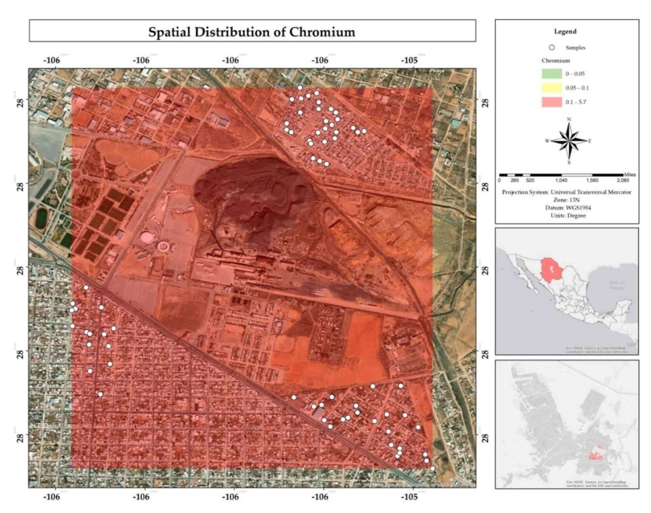
Figure 31.
Spatial distribution of Iron in mg/L in water in the residential area of the Ávalos foundry.
Figure 31.
Spatial distribution of Iron in mg/L in water in the residential area of the Ávalos foundry.
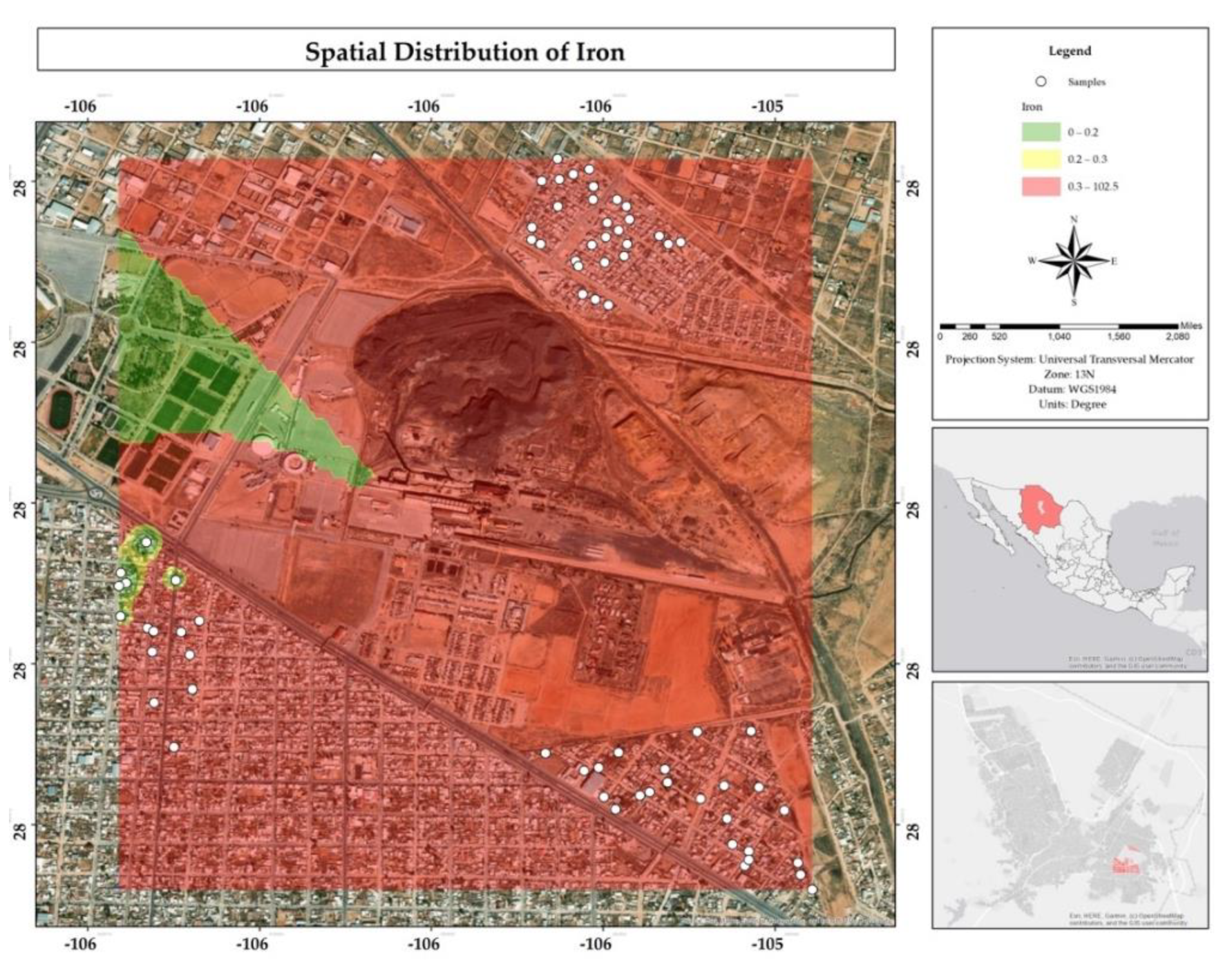
Figure 32.
Spatial distribution of Manganese in mg/L in water in the residential area of the Ávalos smelter.
Figure 32.
Spatial distribution of Manganese in mg/L in water in the residential area of the Ávalos smelter.
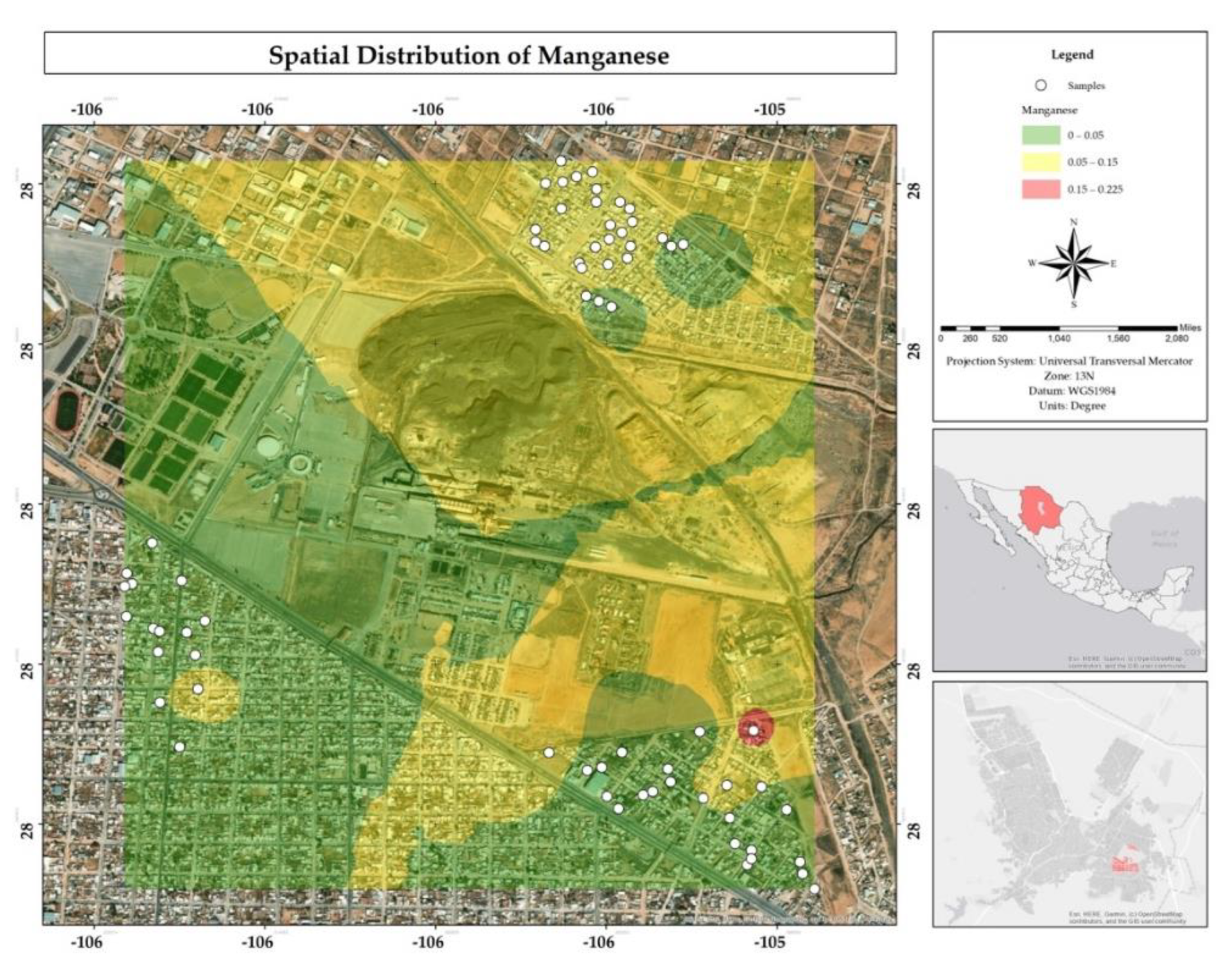
Figure 33.
Spatial distribution of Nickel in mg/L in water in the residential area of the Ávalos smelter.
Figure 33.
Spatial distribution of Nickel in mg/L in water in the residential area of the Ávalos smelter.
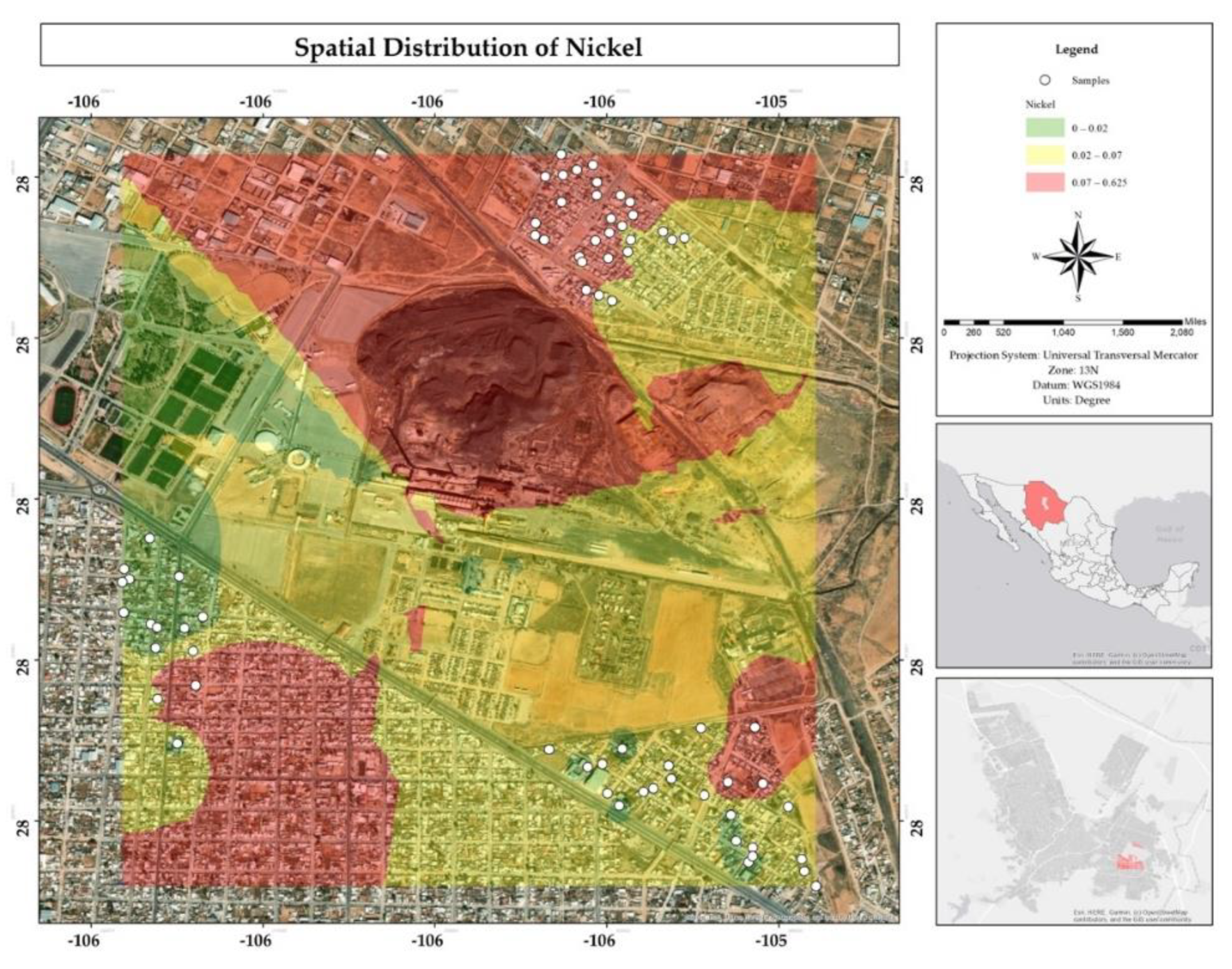

Table 1.
Housing of the study area (Source: INEGI, 2020).
| Total number of housing units | 5,773 |
|---|---|
| Total number of private housing units | 5,627 |
| Occupied private housing units | 4,634 |
| Unoccupied private housing units | 853 |
Table 2.
Population distribution by age cohorts in the study area (Source: INEGI, 2020).
| Total population | 14,187 |
|---|---|
| Female population | 7,198 |
| Male population | 6,868 |
| Population aged 0 to 14 years | 2,935 |
| Population aged 15 to 29 years | 3,238 |
| Population aged 30 to 59 years | 5,533 |
| Population aged 60years and older | 2,190 |
| Population with disabilities | 513 |
Table 3.
Average concentrations of metals and metalloids in water compared to the maximum permissible levels defined in Mexican, American and European regulations.
Table 3.
Average concentrations of metals and metalloids in water compared to the maximum permissible levels defined in Mexican, American and European regulations.
 |
Disclaimer/Publisher’s Note: The statements, opinions and data contained in all publications are solely those of the individual author(s) and contributor(s) and not of MDPI and/or the editor(s). MDPI and/or the editor(s) disclaim responsibility for any injury to people or property resulting from any ideas, methods, instructions or products referred to in the content. |
© 2025 by the authors. Licensee MDPI, Basel, Switzerland. This article is an open access article distributed under the terms and conditions of the Creative Commons Attribution (CC BY) license (http://creativecommons.org/licenses/by/4.0/).
Copyright: This open access article is published under a Creative Commons CC BY 4.0 license, which permit the free download, distribution, and reuse, provided that the author and preprint are cited in any reuse.


