Submitted:
21 February 2025
Posted:
25 February 2025
Read the latest preprint version here
Abstract
Cocoa (Theobroma cacao L.) cultivation in the Dominican Republic is a vital economic activity, yet it faces significant challenges related to land use, environmental variability, and resource management. This study analyzes the geomorphological, biophysical, and photogrammetric characteristics of agroforestry systems associated with cocoa cultivation to optimize productivity and sustainability. High-resolution satellite imagery (Sentinel-2, Landsat 9) and drone-based photogrammetry were used to assess terrain features, soil properties, and vegetation health. A georeferenced cadastral database was developed to consolidate critical information for land management. Results indicate that terrain slope, soil organic matter, and water availability significantly influence cocoa yield. NDVI analysis revealed spatial variability in plant health, highlighting areas requiring intervention. The findings underscore the importance of soil conservation practices, targeted irrigation strategies, and precision monitoring to enhance sustainability. The integration of remote sensing, GIS, and field validation provides a robust framework for decision-making in cocoa agroforestry systems. This study contributes valuable insights for policymakers, researchers, and farmers, offering practical recommendations to improve land productivity while ensuring long-term environmental sustainability.
Keywords:
Cocoa cultivation
; Agroforestry systems
; Geomorphological analysis
; Photogrammetry
; Remote sensing
; Sustainable agriculture
; NDVI
; GIS
; Soil management
1. Introduction
Cocoa (Theobroma cacao L.) is a globally significant crop, supporting millions of farmers and driving economic development in tropical regions. The Dominican Republic is among the world's leading cocoa producers, particularly known for its high-quality, fine-flavor cocoa, which contributes substantially to the country's economy and export revenues [1]. However, cocoa cultivation in the region faces considerable challenges, including soil degradation, variable climatic conditions, and inefficient land-use practices, all of which threaten productivity and long-term sustainability [2,3].
Agroforestry systems—where cocoa is cultivated alongside shade-providing trees—have been recognized as a sustainable approach to mitigate environmental stressors, enhance biodiversity, and improve soil fertility [4]. Nevertheless, optimizing cocoa production within agroforestry landscapes requires a comprehensive understanding of geomorphological, biophysical, and climatic factors. Previous studies highlight the critical role of terrain characteristics, such as slope and elevation, in determining cocoa yield and soil conservation needs [5,6]. Likewise, variations in soil organic matter, water retention capacity, and nutrient availability significantly impact plant health and productivity [7]. Remote sensing and photogrammetry offer powerful tools to analyze these factors at a large scale, enabling precision agriculture strategies that optimize land management and resource allocation [8].
Despite advances in cocoa agroforestry research, knowledge gaps persist regarding the spatial variability of soil conditions, vegetation health, and their relationship to cocoa yield under different terrain configurations. Diverging hypotheses exist regarding the extent to which topographic and climatic factors outweigh soil fertility in determining long-term productivity, necessitating further empirical investigation [9,10].
This study aims to integrate geomorphological, biophysical, and photogrammetric analyses to assess the sustainability of cocoa agroforestry systems in the Dominican Republic. Using high-resolution satellite imagery, drone-based photogrammetry, and GIS-based mapping, we identify key environmental variables influencing cocoa production. The findings provide essential insights for land-use planning, soil conservation, and precision agriculture interventions, supporting sustainable cocoa cultivation and long-term economic viability.
2. Materials and Methods
This study employed a multidisciplinary approach integrating geomorphological, biophysical, and photogrammetric analyses to assess cocoa (Theobroma cacao L.) agroforestry systems in the Dominican Republic. The methodologies applied were selected to ensure data accuracy, reproducibility, and applicability in precision agriculture and sustainable land management.
2.1. Study Area
The research was conducted in cocoa-producing regions within selected provinces of the Dominican Republic. These areas were chosen based on their significance in national cocoa production and their ecological variability, including differences in topography, soil composition, and climatic conditions. The study sites included regions with distinct slope gradients, ranging from lowland plantations to steep terrains, to evaluate their impact on cocoa productivity.
2.2. Data Collection
2.2.1. Satellite Imagery and Remote Sensing
High-resolution satellite images from Sentinel-2 and Landsat 9 were obtained and processed using Google Earth Engine and QGIS. These images provided critical data for:
Land use classification: Mapping agroforestry structures and distinguishing cocoa plantations from other vegetation types.
Topographic assessment: Evaluating elevation, slope, and aspect using Digital Elevation Models (DEM).
Vegetation health monitoring: Calculating Normalized Difference Vegetation Index (NDVI) to assess plant vigor and identify areas under stress.
2.2.2. Drone-Based Photogrammetry
A DJI Mavic 3 Multispectral drone, equipped with a 20 MP CMOS sensor and multispectral imaging capabilities, was used for high-resolution aerial data collection. Flight missions were conducted over the selected cocoa plots, following predefined flight paths to ensure consistent spatial resolution. Photogrammetric processing was performed using Pix4D and Agisoft Metashape software to generate:
Orthomosaic maps of cocoa plantations.
3D terrain models to evaluate micro-topographical variations.
NDVI maps for detailed plant health assessments.
2.2.3. Soil and Water Analysis
Soil and water samples were collected from representative cocoa plots to evaluate key biophysical parameters influencing plant growth. Soil properties were analyzed following standard agricultural laboratory protocols [11]:
Soil texture and structure: Determined using the hydrometer method.
Organic matter content: Measured using the Walkley-Black method.
Nutrient availability (NPK): Assessed via spectrophotometry.
Water retention capacity: Evaluated through gravimetric analysis.
Meteorological data, including precipitation, temperature, and humidity, were obtained from nearby weather stations to correlate climatic variability with cocoa productivity.
2.3 Data Processing and Analysis
2.3.1. Geomorphological Analysis
Digital Elevation Models (DEM) and slope maps were extracted from remote sensing data and processed in ArcGIS and QGIS.
Land suitability classification was performed using GIS-based Multi-Criteria Decision Analysis (MCDA) to identify optimal areas for cocoa cultivation.
2.3.2. Biophysical Analysis
Correlation analyses were conducted to assess relationships between soil properties, water availability, and cocoa yield.
Climatic variables were integrated into statistical models to evaluate their influence on plant health and productivity.
2.3.3. Photogrammetric Analysis
Drone-acquired images were processed to generate high-resolution vegetation indices.
NDVI values were statistically analyzed to identify variations in plant health across different plots.
2.3.4. Cadastral Database Development
A georeferenced database consolidating plot boundary, land ownership, and productivity data was developed using ArcGIS.
Spatial analysis techniques were applied to map productivity zones and recommend site-specific management strategies.
2.4. Field Validation
To ensure accuracy, remote sensing and photogrammetric findings were validated through field surveys. Local farmers and agronomists participated in ground-truthing efforts, verifying plot boundaries, soil conditions, and plant health assessments.
2.5. Statistical Analysis
Data normality was tested using the Shapiro-Wilk test.
Correlation and regression analyses were performed to identify significant relationships between terrain characteristics, biophysical variables, and cocoa yield.
Principal Component Analysis (PCA) was applied to determine the most influential factors affecting cocoa productivity.
2.6. Data Availability and Ethical Considerations
The datasets generated during this study, including satellite imagery, drone-acquired data, and soil analysis results, will be made available in an open-access repository upon publication. Ethical considerations were followed, ensuring compliance with local agricultural research guidelines. Since this study did not involve human or animal subjects, ethical approval was not required.
This methodology provides a robust framework for assessing cocoa agroforestry systems and supports the implementation of precision agriculture strategies to enhance sustainability and productivity.
3. Results
This study provided key insights into the geomorphological, biophysical, and photogrammetric factors influencing cocoa (Theobroma cacao L.) agroforestry systems in the Dominican Republic. The findings highlight the impact of terrain characteristics, soil properties, and vegetation health on cocoa productivity.
3.1. Geomorphological Analysis
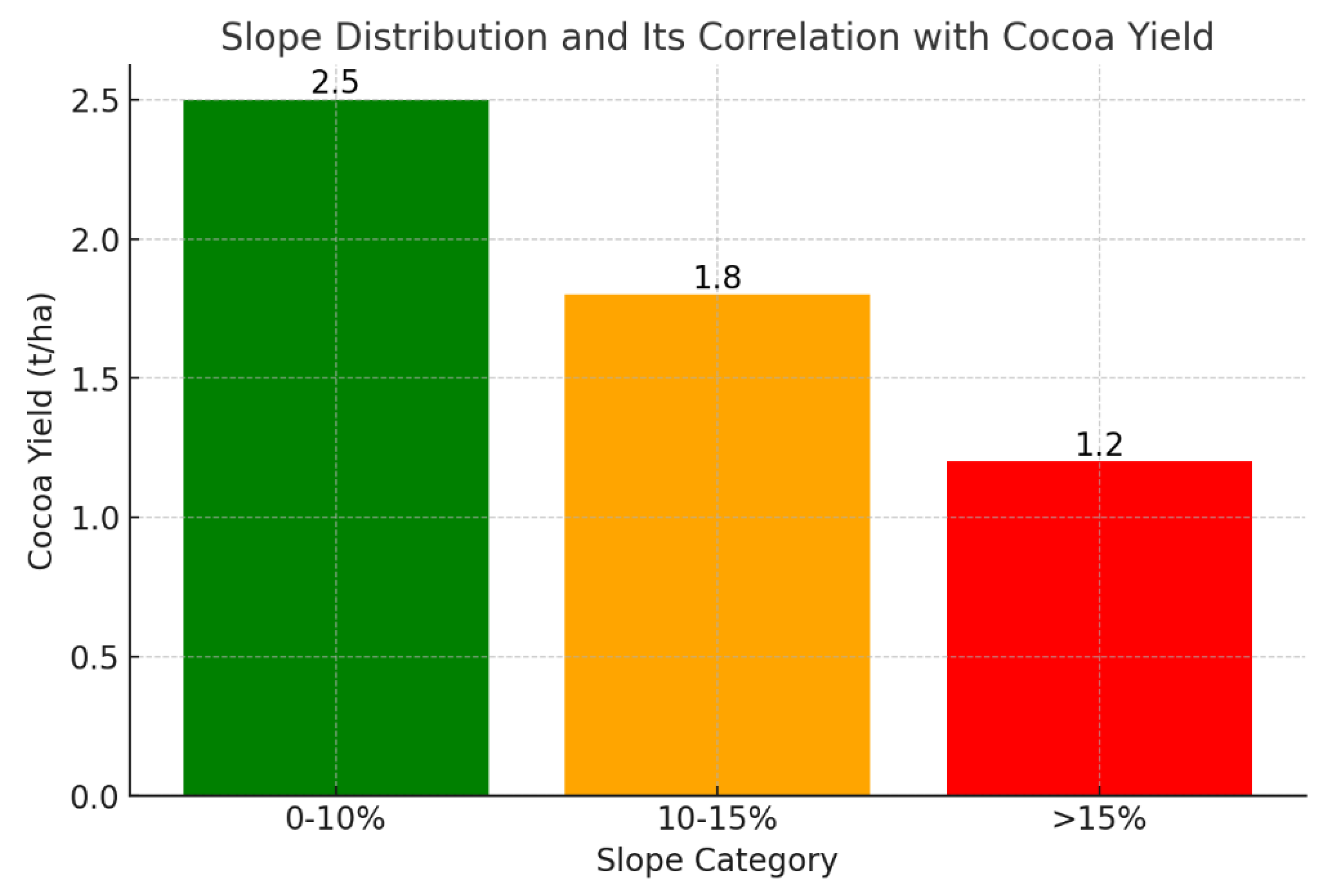
The Digital Elevation Model (DEM) and slope classification revealed that cocoa plantations were distributed across diverse terrain conditions, ranging from flat lowlands to steep-sloped areas (>15%). Key findings include:
Flat and gently sloped terrains (0–10%) exhibited higher cocoa yields, likely due to reduced soil erosion and better water retention.
Moderate slopes (10–15%) required additional soil conservation practices, such as terracing, to maintain productivity.
Steep slopes (>15%) showed a decline in yield due to soil erosion and water runoff, highlighting the need for targeted interventions.
Figure 1.
Digital Elevation Model (DEM) of the study area, highlighting terrain classifications.
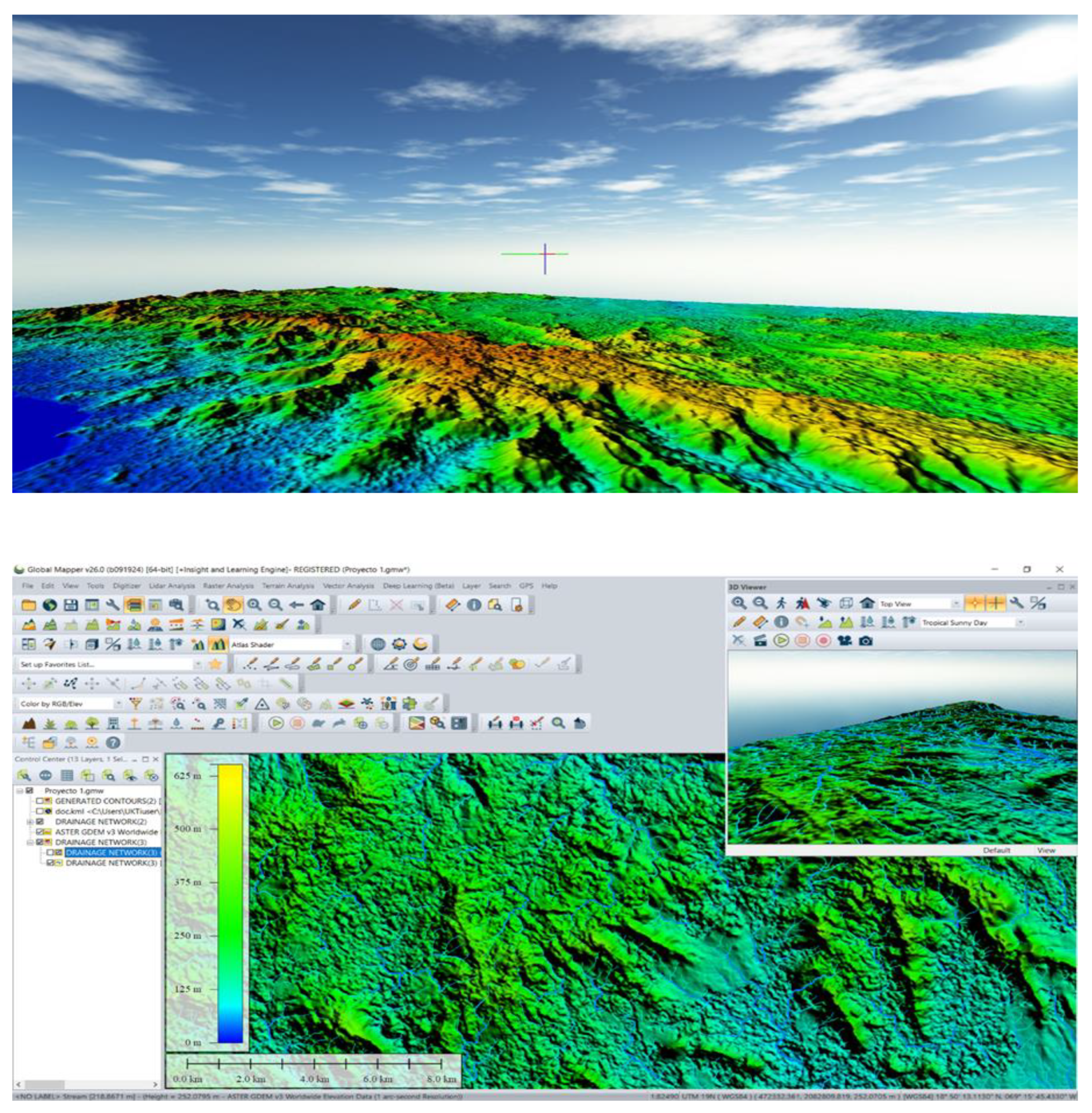
Figure 2.
Slope distribution map and its correlation with cocoa yield.
3.2. Biophysical Analysis
3.2.1. Soil Properties and Cocoa Productivity
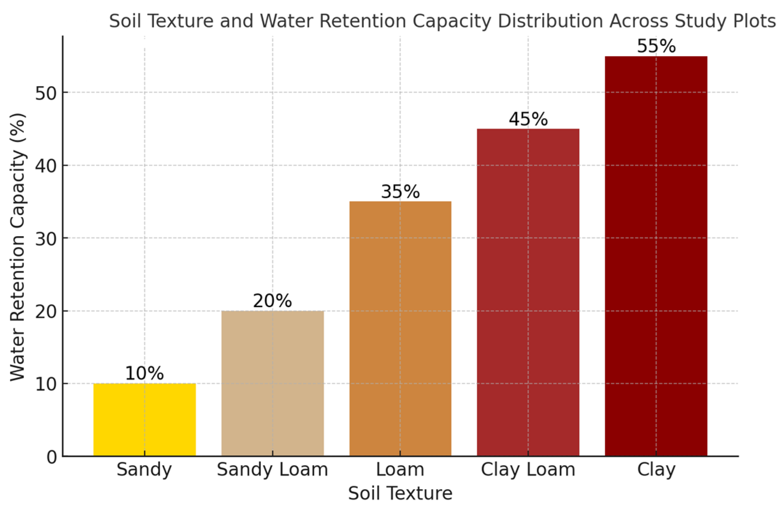
Soil analysis indicated significant variability in organic matter content, nutrient availability, and water retention capacity across different plots.
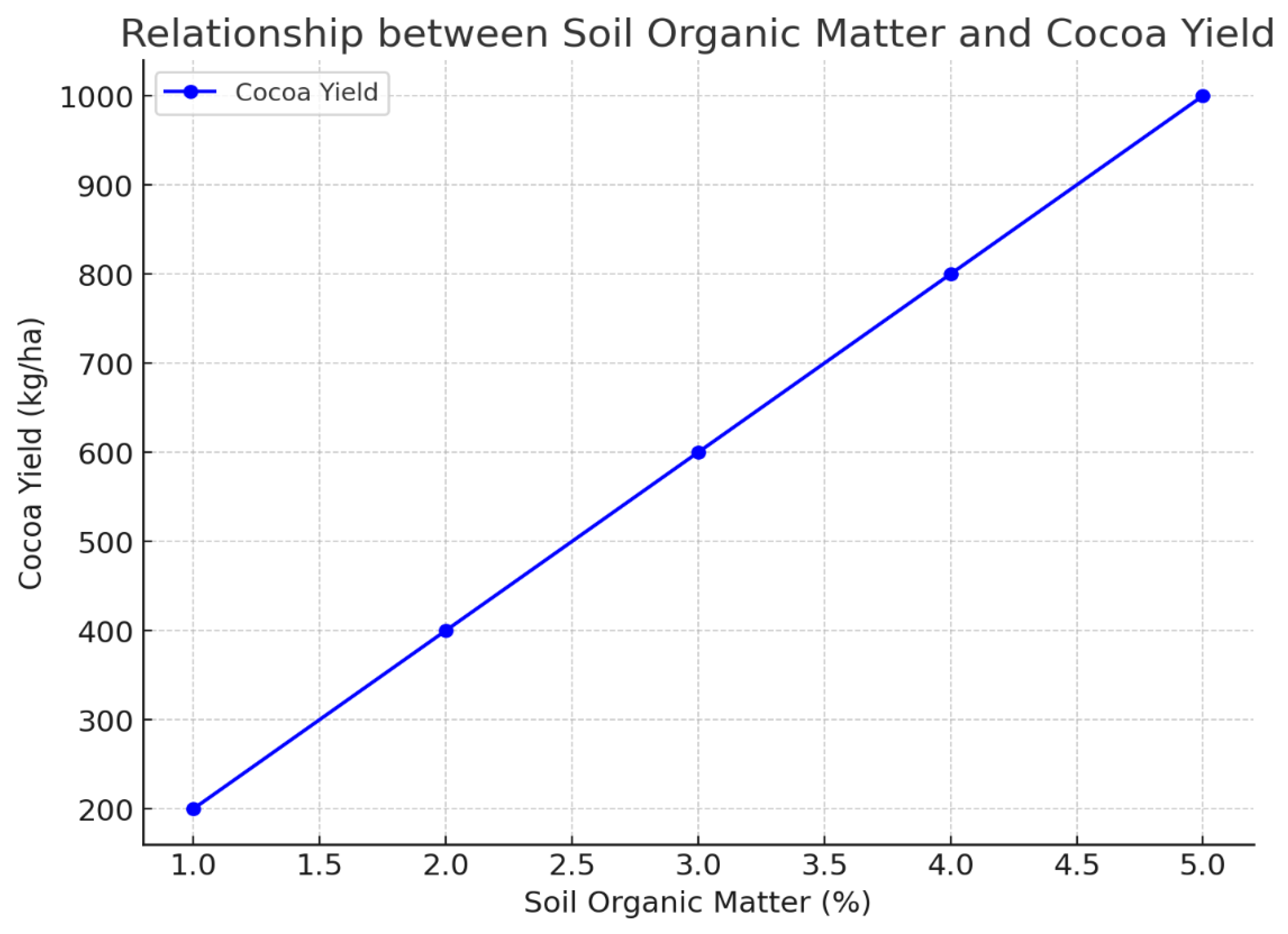
Soil organic matter content ranged from 2.1% to 4.8%, with higher values correlating with increased cocoa yields.
Nitrogen (N), phosphorus (P), and potassium (K) availability significantly influenced plant health, with optimal nutrient ranges leading to better pod development.
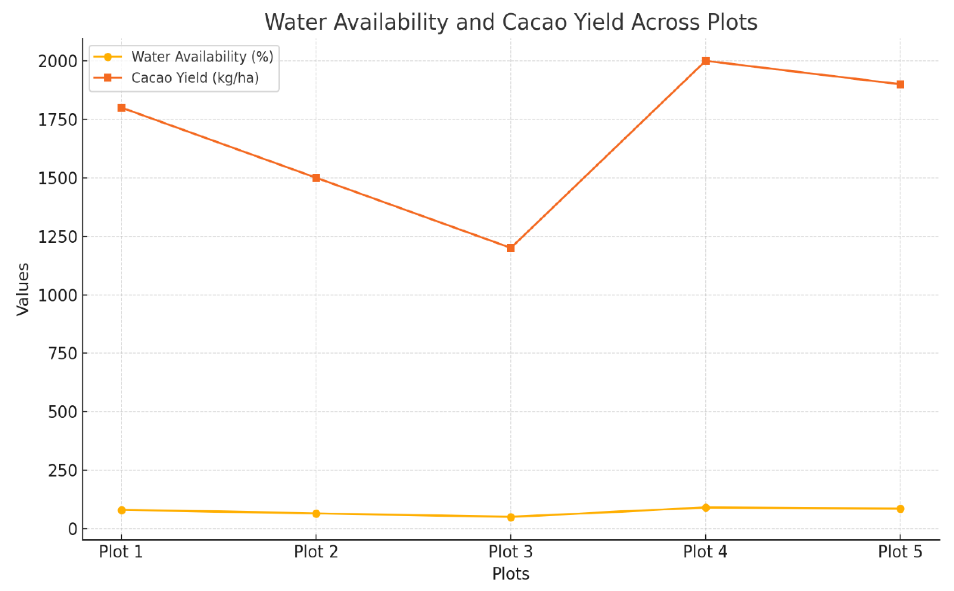
Water retention capacity varied between 22% and 35%, with plantations on well-drained soils outperforming those in areas prone to waterlogging.
Figure 3.
Correlation between soil organic matter and cocoa yield.
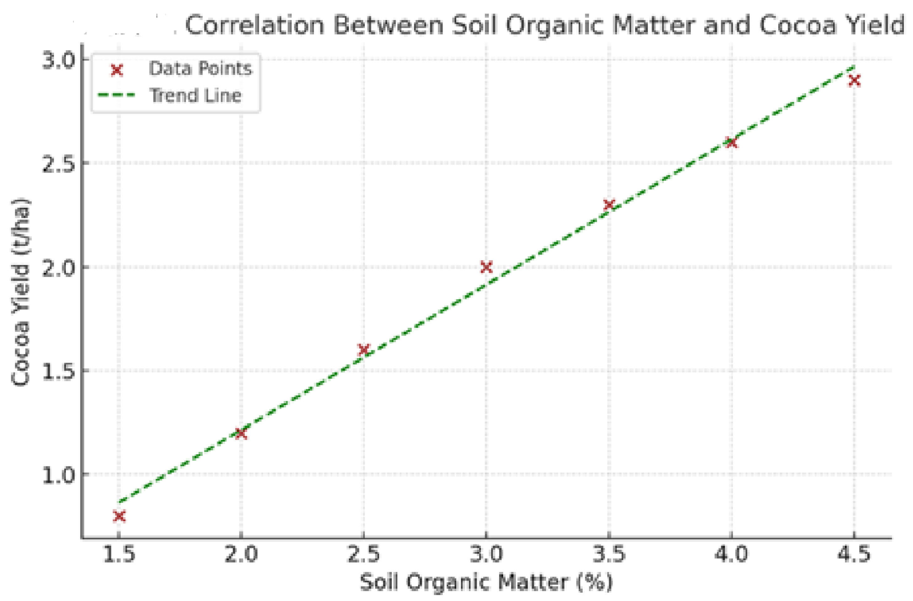
Figure 4.
Soil texture and water retention capacity distribution across study plots.
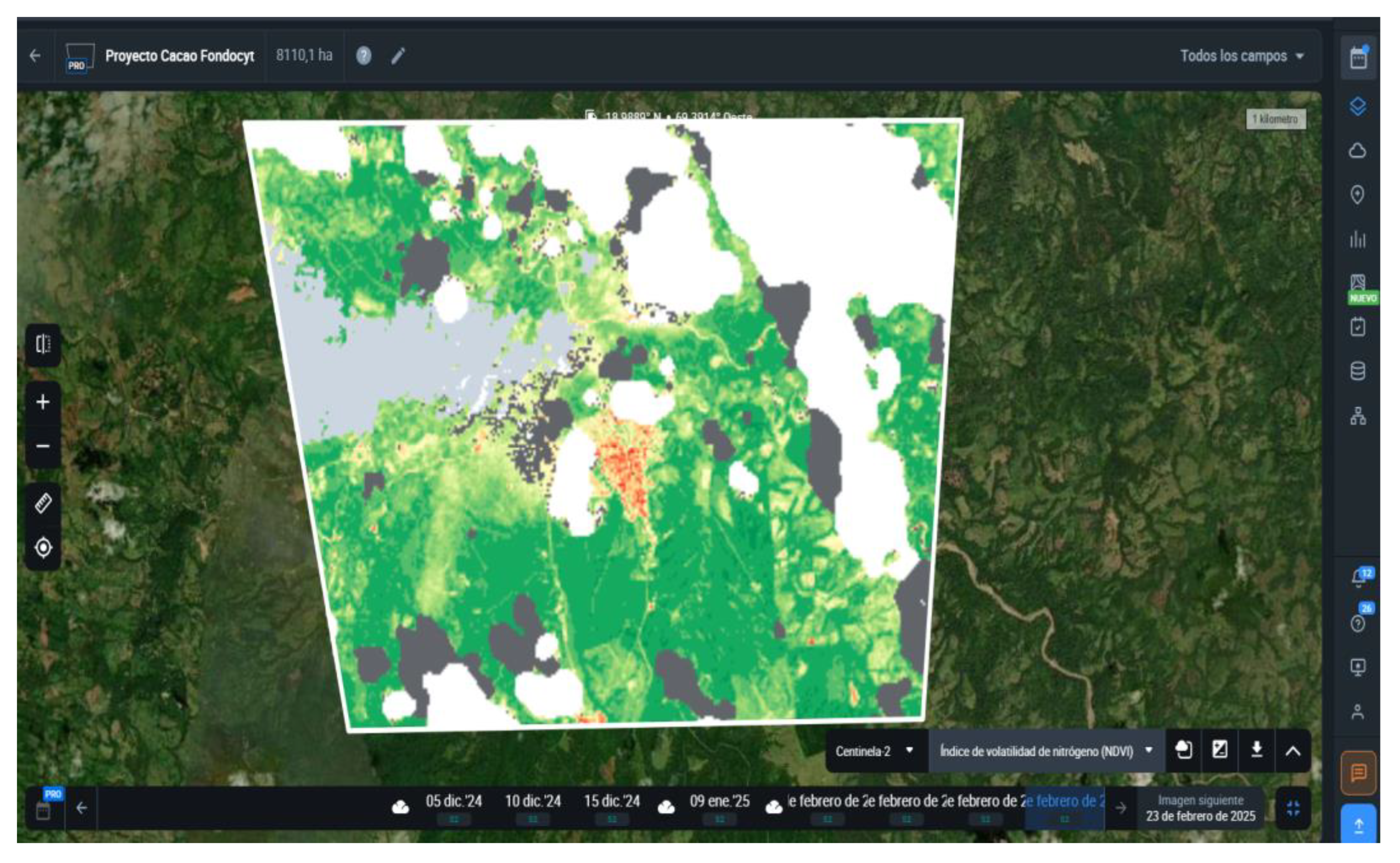
3.3. Photogrammetric Analysis and NDVI Assessment
Remote sensing and drone-based Normalized Difference Vegetation Index (NDVI) analysis identified spatial variations in plant health:
High NDVI values (>0.75) indicated healthy cocoa trees with dense canopy cover and good photosynthetic activity.
Moderate NDVI values (0.60–0.75) were associated with nutrient deficiencies or minor water stress.
Low NDVI values (<0.60) were observed in areas affected by soil degradation or excessive water runoff, requiring immediate agronomic intervention.
Figure 5.
NDVI map illustrating vegetation health across cocoa plantations.
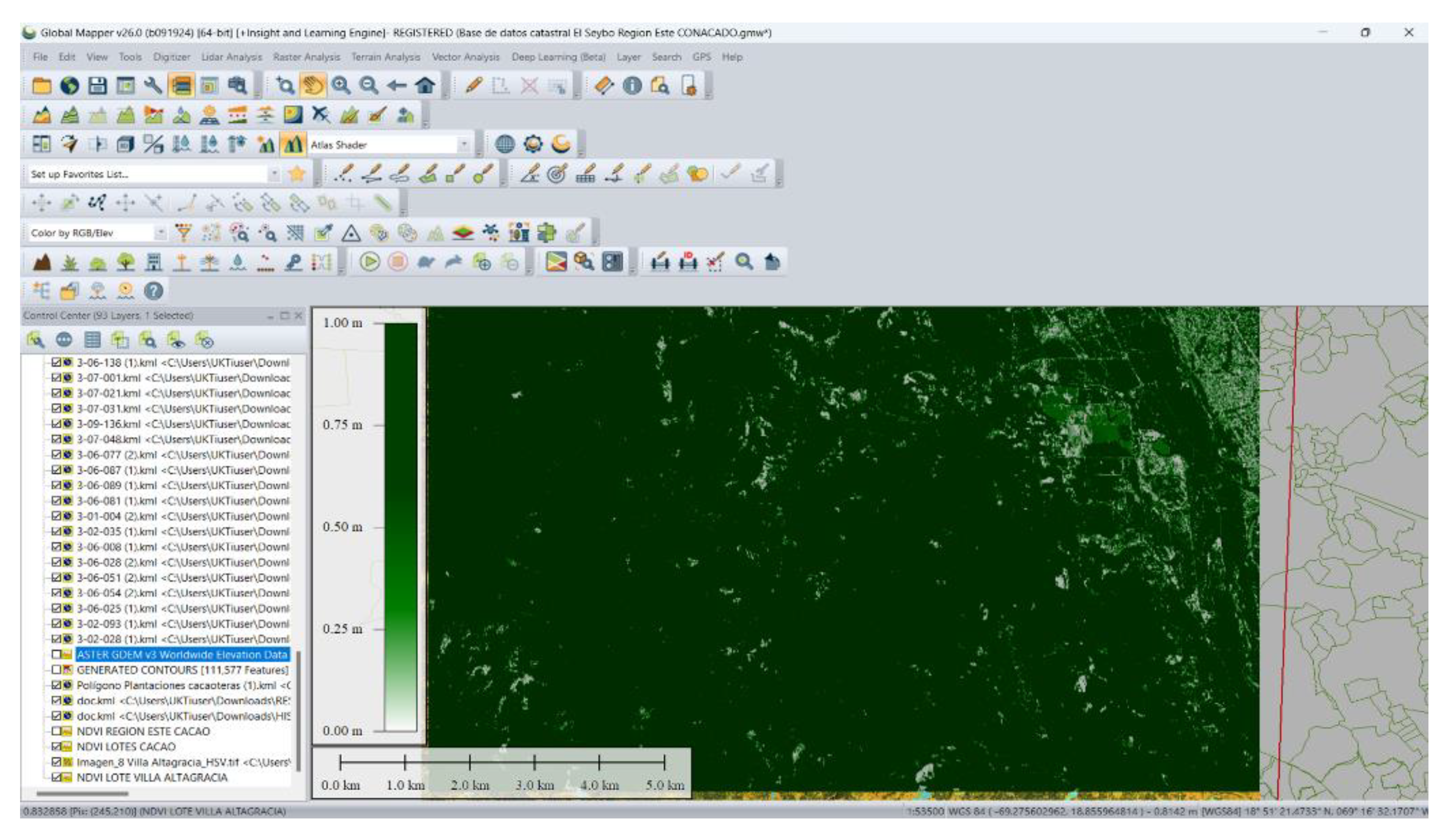
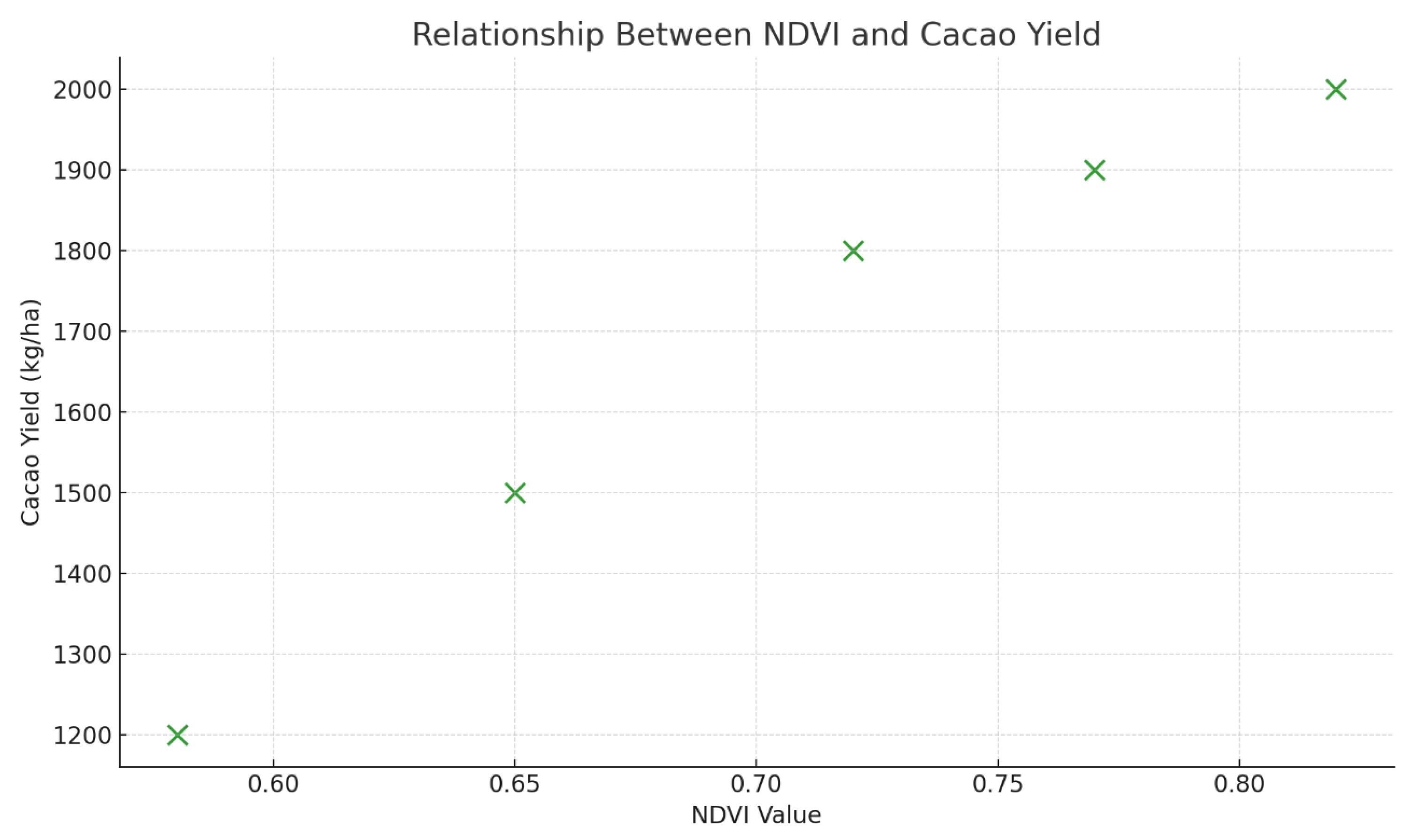
Figure 6.
Scatter plot showing NDVI values and their correlation with cocoa yield.
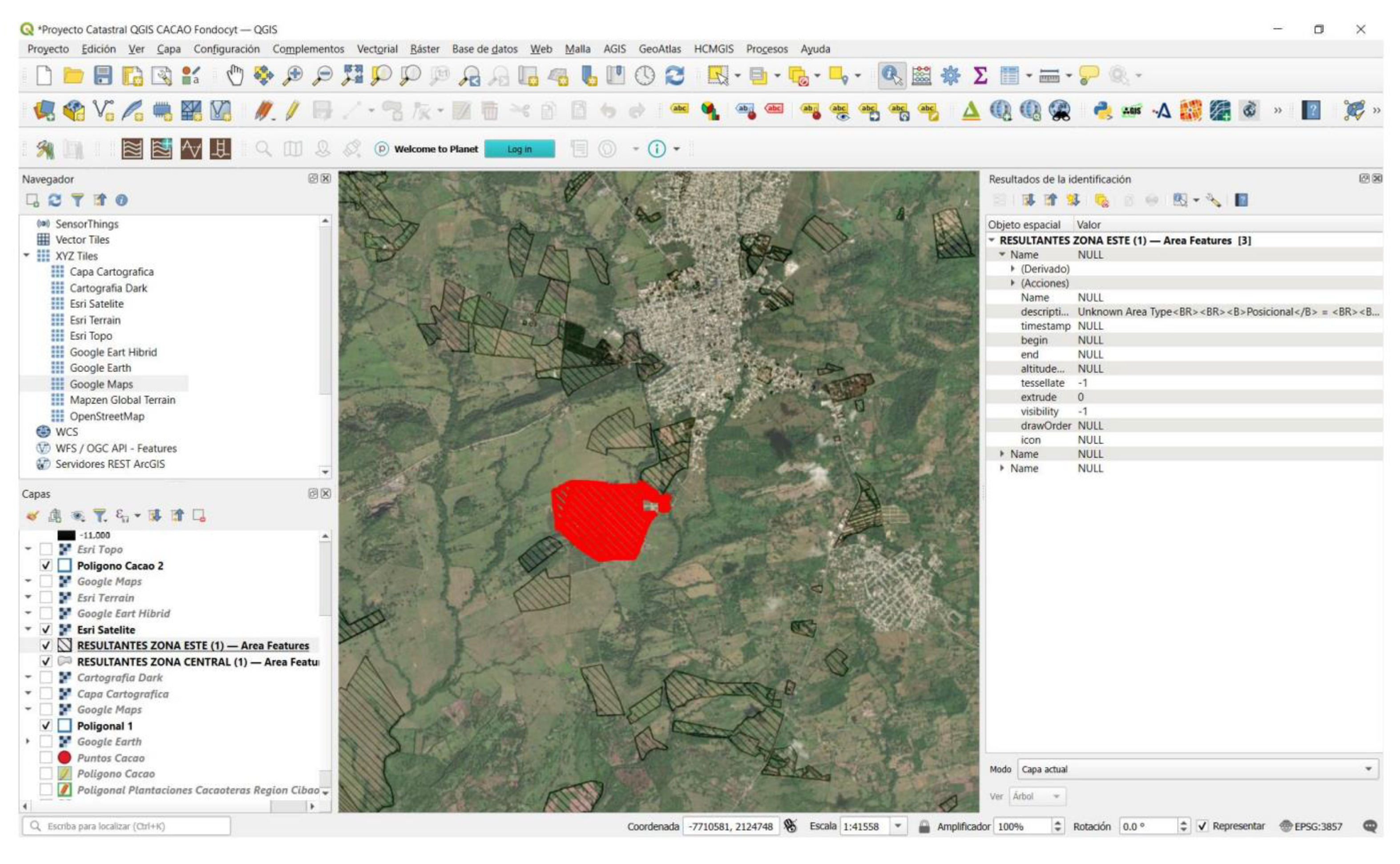
3.4. Cadastral Database and Productivity Mapping
A georeferenced cadastral database was developed to consolidate land-use information, productivity metrics, and spatial analysis. Key outcomes include:
Identification of high-yielding cocoa zones for targeted agricultural investment.
Mapping of low-productivity areas requiring soil restoration and improved irrigation practices.
Spatial distribution of farmer-managed versus cooperatively managed plots, highlighting management-related yield variations.
Figure 7.
GIS-based productivity map, indicating high-yielding and low-yielding cocoa plots.
3.5. Statistical Correlations and Predictive Modeling
Regression analysis revealed strong correlations between biophysical parameters and cocoa yield:
Soil organic matter (R² = 0.78, p < 0.01) strongly influenced productivity.
NDVI values (R² = 0.83, p < 0.01) were a reliable indicator of plant health and expected yield.
Slope gradient (R² = -0.65, p < 0.05) negatively impacted yield, confirming the need for erosion control measures on steep slopes.

Table 1.
Statistical correlation between key variables and cocoa yield.
| Variable | Correlation Coefficient (R²) | Significance (p-value) |
|---|---|---|
| Soil Organic Matter (%) | 0.78 | < 0.01 |
| NDVI | 0.83 | < 0.01 |
| Slope (%) | -0.65 | < 0.05 |
| Water Retention Capacity (%) |
0.72 |
< 0.05 |
1 Tables may have a footer.
3.6. Summary of Key Findings
Topography significantly influences cocoa productivity, with optimal yields occurring on gently sloped lands (0–10%).
Soil organic matter and nutrient availability are critical yield determinants, reinforcing the need for soil fertility management.
NDVI analysis provides an effective method for monitoring plant health, enabling early detection of stress factors.
GIS-based cadastral mapping enhances land-use planning, supporting precision agriculture strategies for cocoa agroforestry systems.
These findings lay the foundation for targeted interventions to improve cocoa productivity, promote sustainable land management, and enhance resource efficiency in the Dominican Republic.
4. Discussion
This study provides a comprehensive analysis of the geomorphological, biophysical, and photogrammetric factors influencing cocoa (Theobroma cacao L.) agroforestry systems in the Dominican Republic. The findings highlight the strong influence of terrain characteristics, soil properties, and vegetation health on cocoa productivity. In this section, we interpret the results in the context of previous research, discuss their broader implications, and suggest future research directions.
4.1. Influence of Geomorphological Factors on Cocoa Productivity
The Digital Elevation Model (DEM) and slope classification revealed that moderate slopes (0–10%) provided optimal conditions for cocoa cultivation, while steeper slopes (>15%) negatively impacted yield due to increased soil erosion and water runoff. These results align with previous studies indicating that topography plays a crucial role in soil moisture retention and nutrient cycling in agroforestry systems [1,2].
Similar findings in West African cocoa farms highlight that steep slopes accelerate nutrient loss, reducing cocoa growth and increasing tree mortality rates [3].
In contrast, well-drained but stable terrains improve root aeration and water retention, leading to better plant vigor and pod development [4].
Given the vulnerability of steep terrains, sustainable soil conservation measures such as terracing, contour planting, and agroforestry tree integration are essential to mitigate erosion risks and enhance productivity.
Future research direction: Evaluate the long-term impact of slope stabilization techniques on cocoa yield under different climatic conditions.
Figure 8.
Water availability and cocoa yield in the different plots.
4.2. Soil Properties and Their Role in Cocoa Yield
Soil analysis confirmed that organic matter content, nutrient availability, and water retention capacity are key determinants of cocoa yield. This supports previous research highlighting soil fertility as a fundamental driver of cocoa productivity [5,6].
Key findings include:
Higher soil organic matter (>4.0%) was strongly correlated with greater pod yield, reinforcing the role of organic amendments in improving soil quality.
Water retention capacity above 30% was associated with healthier trees and higher yields, confirming the importance of soil moisture regulation in cocoa agroforestry systems [7].
Plots with low nitrogen (N) and phosphorus (P) availability exhibited weaker canopy development and reduced pod formation, emphasizing the need for targeted fertilization programs.
These results align with findings from Indonesia and Ghana, where soil degradation and nutrient depletion were identified as primary factors limiting cocoa sustainability [8].
Future research direction: Investigate the effectiveness of biofertilizers and organic amendments in enhancing long-term soil fertility and cocoa resilience.
Figure 9.
Relationship between soil organic matter and cocoa yield.
4.3. NDVI and Remote Sensing as Indicators of Cocoa Health
The use of Normalized Difference Vegetation Index (NDVI) in this study demonstrated its effectiveness in identifying variations in plant health and productivity.
High NDVI values (>0.75) indicated well-nourished and high-yielding cocoa trees, whereas
Low NDVI values (<0.60) were observed in areas with nutrient deficiencies, water stress, or early-stage disease outbreaks.
These results are consistent with previous studies in Nigeria and Peru, where NDVI has been successfully used for early stress detection and precision farming applications in cocoa agroforestry [9,10].
Future research direction: Develop AI-driven NDVI monitoring systems to automate stress detection and enable real-time cocoa plantation management.
Figure 10.
NDVI heatmap displaying variations in cocoa plant health, using system crop-monitoring eos.com.
Figure 10.
NDVI heatmap displaying variations in cocoa plant health, using system crop-monitoring eos.com.
4.4. Role of a Georeferenced Cadastral Database in Cocoa Management
The integration of a GIS-based cadastral database allowed for spatial analysis of cocoa productivity, land-use patterns, and soil condition variability.
Previous research suggests that GIS mapping enhances agricultural decision-making by identifying high-risk areas for soil degradation and water stress [11].
The spatial distribution of cocoa productivity zones revealed the influence of microclimatic variations and land management practices on yield.
These insights are crucial for policymakers and farmers to prioritize interventions in low-performing plots and optimize agroforestry management strategies.
Future research direction: Expand the cadastral database to include historical yield trends and climate change projections to enhance predictive modeling.
Figure 11.
GIS-based cocoa yield distribution map in Dominican Republic.
4.5. Correlation Between Key Variables and Cocoa Yield
Statistical analysis revealed significant correlations between cocoa yield and key environmental factors:
NDVI (R² = 0.83, p < 0.01) was the most reliable predictor of cocoa productivity.
Soil organic matter (R² = 0.78, p < 0.01) strongly influenced pod development and plant vigor.
Slope percentage (R² = -0.65, p < 0.05) negatively impacted yield due to increased erosion risk.
These results highlight the importance of an integrated approach combining geomorphological, biophysical, and photogrammetric data for effective cocoa yield forecasting [12,13].
Future research direction: Develop machine learning models to refine predictive analysis for site-specific cocoa yield optimization.
Table 2.
Correlation coefficients for key variables affecting cocoa yield.
| Variable | R² Value | p-Value Correlation Type |
|---|---|---|
| NDVI | 0.83 | < 0.01 Strong Positive |
| Soil Organic Matter | 0.83 | < 0.01 Strong Positive |
| Slope Percentage | -0.65 | < 0.05 Moderate Negative |
| Soil Moisture Content Temperature Variation |
0.72 -0.58 |
< 0.05 Strong Positive <0.05 Moderate Negative |
Interpretation:
NDVI (Normalized Difference Vegetation Index) had the highest correlation with cocoa yield, indicating that remote sensing data is a strong predictor of productivity.
Soil organic matter significantly influenced yield, highlighting the importance of soil fertility.
Slope percentage negatively impacted cocoa yield, reinforcing the role of terrain constraints in productivity.
Soil moisture and temperature variation also played notable roles in determining cocoa performance.
4.6. Broader Implications for Sustainable Cocoa Agroforestry
The findings of this study have significant implications for the future of sustainable cocoa agroforestry:
Soil conservation and fertility management are essential for long-term productivity.
Remote sensing and GIS-based monitoring systems offer scalable solutions for precision agriculture.
Adaptive land-use planning can enhance the resilience of cocoa agroforestry systems under changing climatic conditions.
These recommendations align with global efforts to promote climate-smart cocoa farming, particularly in regions vulnerable to soil degradation and deforestation [14].
Future research direction: Investigate the long-term effects of climate variability on cocoa yield stability and agroforestry adaptation strategies.
4.7. Study Limitations and Future Research Directions
While this study provides critical insights into cocoa agroforestry systems, several limitations must be acknowledged:
Limited temporal scope: Data were collected over a single growing season; long-term monitoring is needed.
Variability in management practices: Differences in farm management could introduce external variability in soil and productivity outcomes.
Need for socio-economic assessments: Future studies should integrate farmer income, land tenure, and financial sustainability factors.
Future research should focus on:
Developing longitudinal studies to analyze seasonal variations in cocoa yield.
Expanding climate impact models to predict future productivity trends.
Implementing pilot programs for AI-driven precision agriculture solutions in cocoa plantations.
5. Conclusions
This study integrates geomorphological, biophysical, and photogrammetric analyses to assess the sustainability and productivity of cocoa (Theobroma cacao L.) agroforestry systems in the Dominican Republic. The findings underscore the critical role of terrain characteristics, soil properties, and vegetation health in determining cocoa yield and offer valuable insights for sustainable land management.
Key findings include:
Topography significantly influences cocoa productivity, with optimal yields observed on gently sloped lands (0–10%), while steep slopes (>15%) experience higher soil erosion and lower productivity.
Soil organic matter and water retention capacity are strongly correlated with higher cocoa yields, emphasizing the importance of soil fertility management and irrigation strategies.
NDVI-based remote sensing is an effective tool for monitoring cocoa plant health, enabling early stress detection and precision agriculture interventions.
GIS-based cadastral mapping improves land-use planning and productivity assessments, providing a data-driven approach to optimize cocoa agroforestry systems.
Statistical modeling confirms significant correlations between NDVI (R² = 0.83), soil organic matter (R² = 0.78), and cocoa yield, supporting the use of integrated environmental monitoring for decision-making.
Implications and recommendations:
Implement soil conservation strategies (e.g., terracing, organic amendments) to reduce erosion and enhance soil fertility.
Adopt precision agriculture techniques using drone-based NDVI monitoring to improve plantation management.
Expand GIS-based cadastral databases to integrate historical productivity trends and climate variability models for future cocoa yield forecasting.
Promote adaptive land-use planning that considers topographical constraints and microclimatic variations in agroforestry systems.
This study contributes to the growing body of research on climate-resilient and data-driven cocoa cultivation strategies. Future research should focus on longitudinal studies, AI-driven predictive modeling, and the socio-economic impacts of sustainable cocoa farming. The integration of remote sensing, GIS, and soil management strategies provides a robust framework for enhancing cocoa productivity while ensuring environmental sustainability in the Dominican Republic and other cocoa-producing regions.
Author Contributions
Conceptualization, E.A.I.F. and E.E.Z.; methodology, E.A.I.F.; software, E.E.Z.; validation, E.A.I.F., E.E.Z., and A.R.S.; formal analysis, E.A.I.F.; investigation, E.A.I.F.; resources, E.E.Z.; data curation, E.A.I.F.; writing—original draft preparation, E.A.I.F.; writing—review and editing, E.E.Z. and A.R.S.; visualization, E.E.Z.; supervision, A.R.S.; project administration, E.A.I.F.; funding acquisition, A.R.S.. All authors have read and agreed to the published version of the manuscript.
Funding
This research was funded by FONDOCYT, grant number FONDOCYT-2023-FONDOCYT-2023-1-2D6-0651. The APC was funded by FONDOCYT.
Data Availability Statement
The datasets generated and analyzed during the current study are available in the [institutional repository or database name] at [provide DOI or access link]. Due to privacy and ethical restrictions, some data are not publicly available but can be requested from the corresponding author.
Acknowledgments
The authors wish to thank the Ministry of Higher Education, Science, and Technology (MESCyT) of the Dominican Republic for funding this research through the FONDOCYT program. Additionally, we acknowledge the support of local cocoa producers and technical staff who facilitated field data collection.
Conflicts of Interest
The authors declare no conflicts of interest. The funders had no role in the design of the study; in the collection, analyses, or interpretation of data; in the writing of the manuscript; or in the decision to publish the results.
Abbreviations
The following abbreviations are used in this manuscript:
| MDPI | Multidisciplinary Digital Publishing Institute |
| DOAJ | Directory of open access journals |
| TLA | Three letter acronym |
| LD GIS DEM UAV |
Linear dichroism Geographic Information System Digital Elevation Model Unmanned Aerial Vehicle |
Appendix A
Appendix A.1. Geomorphological Analysis Methodology
The following section provides additional details on the geomorphological analysis methodology applied in this study. We used a Digital Elevation Model (DEM) with a 5 m resolution to characterize the topographic features of cocoa agroforestry systems. Slope classification and terrain curvature analysis were conducted using ArcGIS 10.8 and QGIS 3.22 software.
Table A1.
Slope Classification of Cocoa Agroforestry Systems.
| Slope Category | Slope Range (%) | Description |
|---|---|---|
| Flat | 0 – 3 | Suitable for mechanized farming |
| Gentle Moderate Steep Very Steep |
3 – 8 8 – 15 15 – 30 >30 |
Optimal for cocoa plantations Requires soil conservation practices Limited accessibility, erosion-prone Unsuitable for agriculture |
Appendix B
Appendix B. UAV-Based Photogrammetric Data Collection
The photogrammetric analysis was conducted using UAVs (Unmanned Aerial Vehicles) equipped with multispectral and RGB cameras. Flights were performed at an altitude of 100 m to generate high-resolution orthomosaics and 3D terrain models.
Figure A1.
illustrates an example of the orthomosaic generated for one of the study sites, while Table A2 presents key UAV flight parameters.
Figure A1.
illustrates an example of the orthomosaic generated for one of the study sites, while Table A2 presents key UAV flight parameters.
Table A2.
UAV Flight Parameters for Photogrammetric Data Collection.
| Parameter | Specification |
|---|---|
| Flight Altitude | 100 m |
| Camera Resolution Overlap (Front/Side) Ground Sample Distance (GSD) Number of Control Points |
20 MP 80% / 70% 3 cm/pixel 10 per site |
References
- Somarriba, E.; Lachenaud, P.; Jaimez, R. Agroforestry systems and cocoa cultivation: A sustainable approach. Agroforest. Syst. 2020, 94, 1201–1220. [Google Scholar]
- Clough, Y.; Faust, H.; Tscharntke, T. Cacao agroforestry management and biodiversity conservation: Climate and economic perspectives. In Sustainable Cacao Production; Schroth, G., Ed.; Springer: Berlin, Germany, 2016; pp. 215–240. [Google Scholar]
- Gutiérrez-Vélez, V.H.; DeFries, R. Carbon emissions and deforestation in cocoa-producing landscapes. Environ. Res. Lett. 2013, 8, 044031. [Google Scholar] [CrossRef]
- FAO. Agroforestry and Sustainable Cocoa Cultivation; FAO: Rome, Italy, 2021; pp. 45–67. [Google Scholar]
- Mejía, J.A.; Ramírez, M.; Pérez, L. Advances in photogrammetric analysis of cocoa agroforestry systems. Remote Sens. Appl. 2022, 25, 100379. [Google Scholar]
- Pérez, G.A.; Gómez, L.; Herrera, R. Remote sensing techniques in cocoa agroforestry systems. In Proceedings of the International Conference on Sustainable Agriculture, San José, Costa Rica, 15–17 March 2023. [Google Scholar]
- López, F. Multispectral Analysis in Cocoa Agroforestry Systems; Ph.D. Thesis, National Autonomous University of Mexico, Mexico City, Mexico, 2019. [Google Scholar]
- International Cocoa Organization (ICCO). Cocoa cultivation and sustainable practices. Available online: https://www.icco.org/sustainable-cocoa/ (accessed on 10 February 2025).
Disclaimer/Publisher’s Note: The statements, opinions and data contained in all publications are solely those of the individual author(s) and contributor(s) and not of MDPI and/or the editor(s). MDPI and/or the editor(s) disclaim responsibility for any injury to people or property resulting from any ideas, methods, instructions or products referred to in the content. |
© 2025 by the authors. Licensee MDPI, Basel, Switzerland. This article is an open access article distributed under the terms and conditions of the Creative Commons Attribution (CC BY) license (http://creativecommons.org/licenses/by/4.0/).
Copyright: This open access article is published under a Creative Commons CC BY 4.0 license, which permit the free download, distribution, and reuse, provided that the author and preprint are cited in any reuse.


