Submitted:
03 February 2025
Posted:
04 February 2025
You are already at the latest version
Abstract
Land use conflicts pose a growing challenge to sustainable development, particularly in regions experiencing rapid urbanization. This study examines the spatiotemporal dynamics of land use conflicts and their ecological implications in Tianshui City from 1980 to 2020. The objectives are to identify patterns of spatial heterogeneity, explore the driving factors behind land use conflicts, and analyze their relationship with ecological risks.The natural breaks (Jenks) classification method was employed to categorize land use conflicts into five levels, ranging from no conflict to severe conflict, with classification accuracy evaluated using the Kappa coefficient, achieving a minimum value of 0.83. Semivariance geostatistical analysis was applied to assess spatial heterogeneity, revealing that structural factors such as topography and climate dominated in the early years, while stochastic factors, including urbanization and socio-economic development, became increasingly influential over time. Bivariate LISA clustering analysis highlighted a strong spatial correlation between high land use conflicts and ecological risks, particularly in areas undergoing rapid transitions, such as the conversion of arable land to urban uses.The results indicate a significant expansion of high-conflict and severe-conflict zones, particularly in urban and agriculturally fertile regions, accompanied by a decline in conflict-free areas. The aggregation of high-risk activities, such as urban sprawl and industrial development, has further exacerbated ecological risks. These findings underscore the need for integrated land use policies that prioritize ecological protection, promote sustainable urban expansion, and mitigate the impacts of land use conflicts. Future research should incorporate emerging drivers, such as climate variability, and develop advanced models to improve the prediction and management of land use conflicts and their ecological consequences.
Keywords:
land use conflict
; ecosystem service value
; ecological risk
; FLUS model
1. Introduction
Achieving sustainable socio-economic development on a global scale has become a shared goal for humanity[1]. However, land use conflicts have emerged as a critical obstacle to the sustainable utilization of land resources, attracting significant attention worldwide[2]. The concept of "conflict," rooted in Western sociology, refers to the incompatibility or mutual exclusion between two or more social units[3], often resulting in psychological or behavioral contradictions[4]. As human activities increasingly strain land resources[5], scholars have extended the concept of conflict to the realm of resource utilization, positing that land use conflicts fundamentally reflect interest-based disputes arising from competing claims on land[6]. This has prompted extensive research into the concept, drivers, and dynamics of land use conflicts, leading to the emergence of diverse theoretical perspectives[7]. The modern study of land use conflicts gained prominence in the 1960s and 1970s, as these conflicts became more frequent due to the global scarcity of land resources[8]. This issue was particularly acute in developing countries with uneven resource distribution and in nations undergoing rapid industrialization[9]. Land use conflicts are widely regarded as the product of both internal and external factors[10]. Internally, they arise from the inherent multi-suitability and limited availability of land resources[11]. Externally, social factors such as urban expansion, population growth, and increasing demands for land intensify the competition and exacerbate conflict development[12].
In recent years, research on land use conflicts has primarily centered on conceptual frameworks, causal analyses, and theoretical diagnostics[13]. However, practical application studies remain relatively underdeveloped[14]. Specifically, there is a significant gap in comprehensive assessments of land use conflict intensity within specific regions, investigations into the intrinsic mechanisms driving the evolution of such conflicts, and simulations or predictions of future land use disputes[15]. These limitations underscore the need for more targeted, region-specific, and forward-looking analyses[16]. Ecological security research, on the other hand, emphasizes the coordination between socio-economic development and ecological protection[17]. It underscores the dual imperative of preserving natural ecosystems while optimizing their sustainable use to support human development. Grounded in the "Pressure-State-Response" (PSR) model and an ecosystem indicator framework, ecological security research predominantly focuses on balancing production and living functions[18]. However, limited attention has been given to exploring the coupling relationship between ecological security and land use conflicts, or to understanding the evolutionary mechanisms underlying these conflicts from an ecological security perspective[19]. Addressing land use conflicts through the lens of ecological security is therefore essential to advancing both theoretical and practical knowledge in this field[20]. Methodologically, a range of approaches have been employed to study land use conflicts[21], including participatory surveys, PSR models, landscape ecological risk assessments, evaluation game theory, and multi-objective planning methods[22]. These tools provide a strong foundation for integrating ecological security considerations into the analysis of land use conflicts, enabling more holistic and sustainable solutions[23].
With the rapid development of the Tianshui urban agglomeration, there is a pressing need to coordinate the dynamic processes and coupling mechanisms among urban growth, arid-zone agriculture, and the ecological environment[24]. To address this challenge, the present study establishes a comprehensive framework for measuring land use conflicts from the perspective of ecological security. Specifically, it integrates an ecosystem service value system and ecological risk indicators within an ecological security framework, using them to characterize and overlay responses related to land use conflicts. This approach enables a detailed analysis of the spatiotemporal evolution of land use conflicts in Tianshui City, along with simulations of their spatial patterns under various future scenarios. The findings offer significant theoretical and practical insights for safeguarding regional ecological security while balancing ecological protection with socio-economic development. Moreover, this research extends existing studies on land use conflicts, broadening both the content and scope of investigations into land use change.
2. Materials and Methods
2.1. Study Area
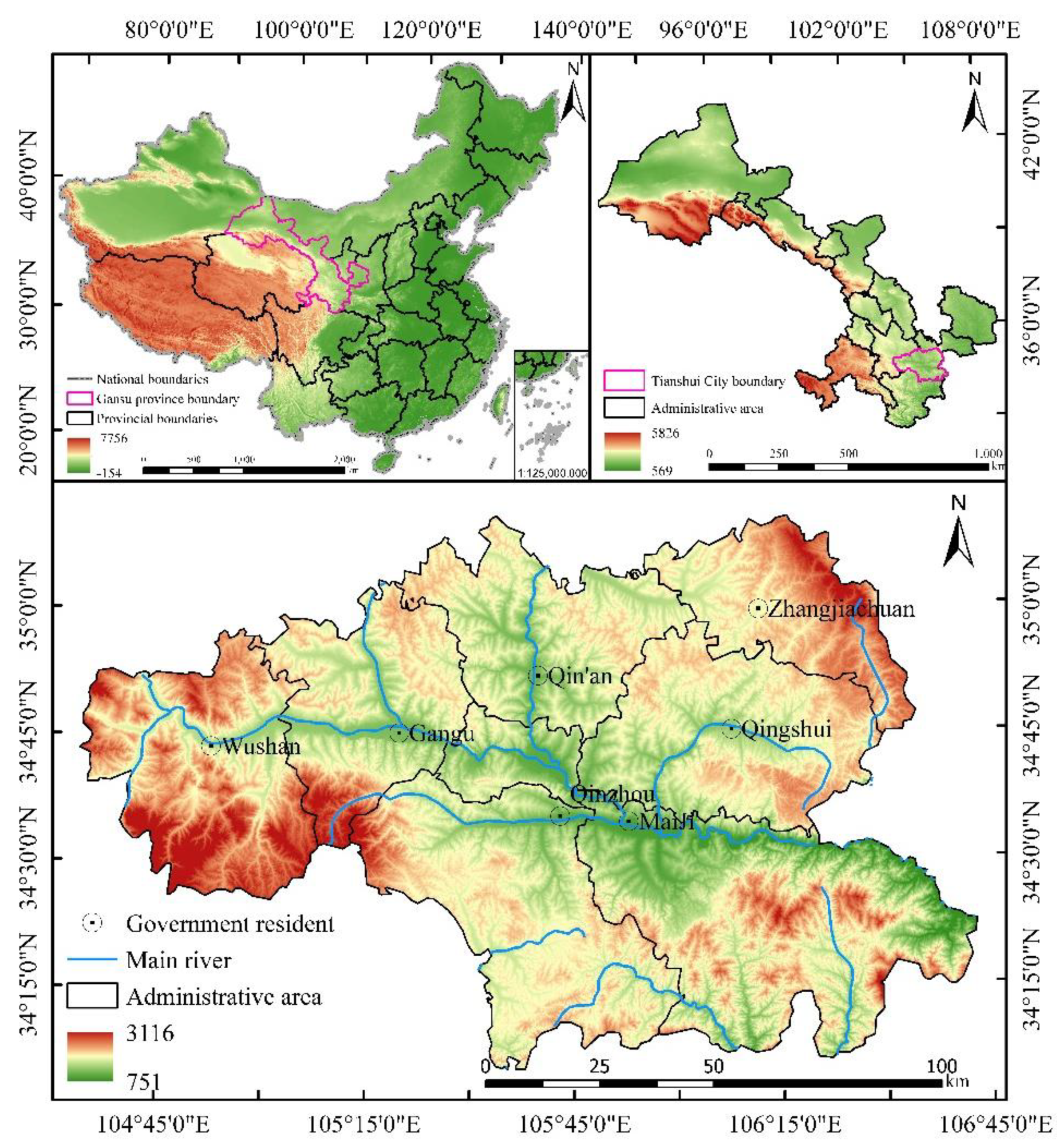
Tianshui City lies between 104°35′ and 106°44′ E longitude, and 34°05′ and 35°10′ N latitude.This region features a complex mountainous terrain with an elevation gradient that rises in the northwest and descends in the southeast, ranging from 751 m to 3116 m, with an average elevation of approximately 1925 m.The highest peak, Tianye Liang, stands at 3116 m, while the lowest point, Niubei Village, is at 751 m.Tianshui spans the Yangtze River and Yellow River basins, with the West Qinling Mountains acting as the watershed divide. The northern area lies within the Weihe River basin, while the southern region is part of the Jialing River basin.Tianshui City experiences a temperate monsoon climate, with an annual average temperature of approximately 11°C and a frost-free period of about 185 days.The annual average precipitation is approximately 574 mm, decreasing progressively from southeast to northwest.Based on China's 2024 national census, Tianshui covers an area of approximately 14,300 square kilometers and supports a resident population of about 3.72 million.Rapid urbanization and population growth in Tianshui City have significantly altered land use patterns, affecting various aspects of the ecological environment.As a rapidly urbanizing city in China, Tianshui faces growing demands for land resources to accommodate human habitation and development.However, this process has exacerbated conflicts between ecological conservation and land use practices.
Figure 1.
Schematic diagram of the study area.
2.2. Data Sources and Processing
The datasets employed in this research primarily include the following:DEM data, sourced from the GDEM product on the Geospatial Data Cloud Platform, with a spatial resolution of 30 meters. Slope and terrain ruggedness were derived using GIS spatial analysis tools.NDVI data, retrieved from NASA's website, comprises 16-day composite MODIS data with a spatial resolution of 250 meters. NDVI values and vegetation coverage were computed using the Maximum Value Composite (MVC) method.Meteorological data, acquired from the China Meteorological Data Network’s standard climate dataset, includes daily observational records.Road network, river network, and administrative vector data, obtained from the China Resource Environment Science Data Platform (https://www.resdc.cn/).Economic indicators for Tianshui City, including GDP, per capita GDP, total values of secondary and tertiary industries, population size, agricultural and urban population counts, and population density, were primarily derived from the statistical yearbooks of Gansu Province and Tianshui City.
2.3. Research Methodology
2.3.1. Construction of the Land Use Conflict Measurement Model
Land use conflicts from an ecological security perspective mainly arise from contradictions and spatial competition caused by the misalignment and overlap of arable land, construction land, and ecological safety spaces under intensive human activities[25]. The PSR model and its extended variants within landscape ecology provide a framework for evaluating complex environmental issues[26], resource security challenges, and sustainability concerns related to land use. This approach integrates fuzzy mathematical methods to establish evaluation criteria for land ecosystems, analyze causal relationships between system elements, and monitor continuous feedback mechanisms among indicators[27]. Characterized by its systematic and comprehensive nature, this methodology effectively identifies causal chains between human activities and their impacts on ecosystems.Consequently, this methodology facilitates the diagnosis of land ecosystem states and responses to land use pressures, offering valuable insights into land use conflict analysis[28].
The indicator system for land use conflicts comprises key elements within the PSR model[29]. Pressure (P) represents the intensity and trends of land resource development and utilization, driven by anthropogenic factors that threaten the ecological environment of arable land[30]. The Land Use Disturbance Index, as a major indicator of external causes and risks for land use conflicts, represents the landscape's resilience to external disturbances and its self-recovery capacity, reflecting the pressures faced by the land system[31]. Within the PSR model, State (S) reflects changes in the elements of the land ecological environment. The Vulnerability Index captures states of damage resulting from an inability to adapt to environmental and social changes.Response (R) in the PSR model reflects societal or individual measures aimed at halting, mitigating, preventing, or reversing adverse changes to land ecosystems[32].From the perspective of land use systems, the Stability Index reflects both the consistency and continuity of production processes, as well as the persistence of system states or spatial forms, including their inherited characteristics (Figure 2).
This research, guided by the proposed model and tailored to the resource and environmental characteristics of Tianshui City, seeks to develop a comprehensive index (F) for assessing land use conflict. This index is based on three key components: the System Interference Degree Index (FAWMPFD), the Vulnerability Index (FFI), and the Stability Index (FSI)[33].A systematic evaluation method is proposed, requiring the standardization of calculation results within the range of (0, 1)[34].The calculation formula is presented as follows:
F=FAWMPFD+FFI-FSI
The Land Use Disturbance Index (FAWMPFD measures the extent of disturbance across landscape units, with higher values reflecting a greater degree of impact.The formula for its calculation is provided below:
In the formula: Pij represents the perimeter (km) of the j-th patch of land use type i; aij denotes the area (km²) of the j-th patch of land use type i ; A represents the total area (km²) of all land use types within the spatial unit; m indicates the total number of land use types; and n refers to the total number of patches within the spatial unit.
The Land Use Fragility Index (FFI) measures the extent to which spatial patches are affected by external pressures. Higher FFI values indicate greater susceptibility to external impacts and an elevated likelihood of land use conflicts[35].
In this formula: ai represents the area (km²) of land use type iii within the regional unit, Fi denotes its corresponding vulnerability, A is the total area (km²) of all land use types in the regional unit, and m indicates the total number of land use types.
The Land Use Stability Index (FSI) measures the degree of stability within spatial units. Higher FSI values reflect stronger impacts, which may exacerbate land use conflicts[36].The calculation formula is presented below:
In this formula: A denotes the total area (km²) of all land use types within the regional unit, and ni refers to the number of patches of the i-th land use type within the regional unit.
2.3.2. Modeling and Forecasting the Spatial Distribution of Land Use Conflicts
To analyze the spatial distribution characteristics of land use in 2030, this study utilizes the FLUS model, which integrates two key components: a neural network (ANN) for calculating occurrence probabilities and a cellular automaton (CA) with an adaptive inertia competition mechanism[37]. Initially, land use data is combined with geographic detection factors, and the occurrence probability for each land type is computed at the pixel level using ANN, yielding development probabilities for various land categories[38]. Next, a roulette wheel selection-based competitive mechanism is applied to generate simulated land use prediction maps for Tianshui City in 2030.
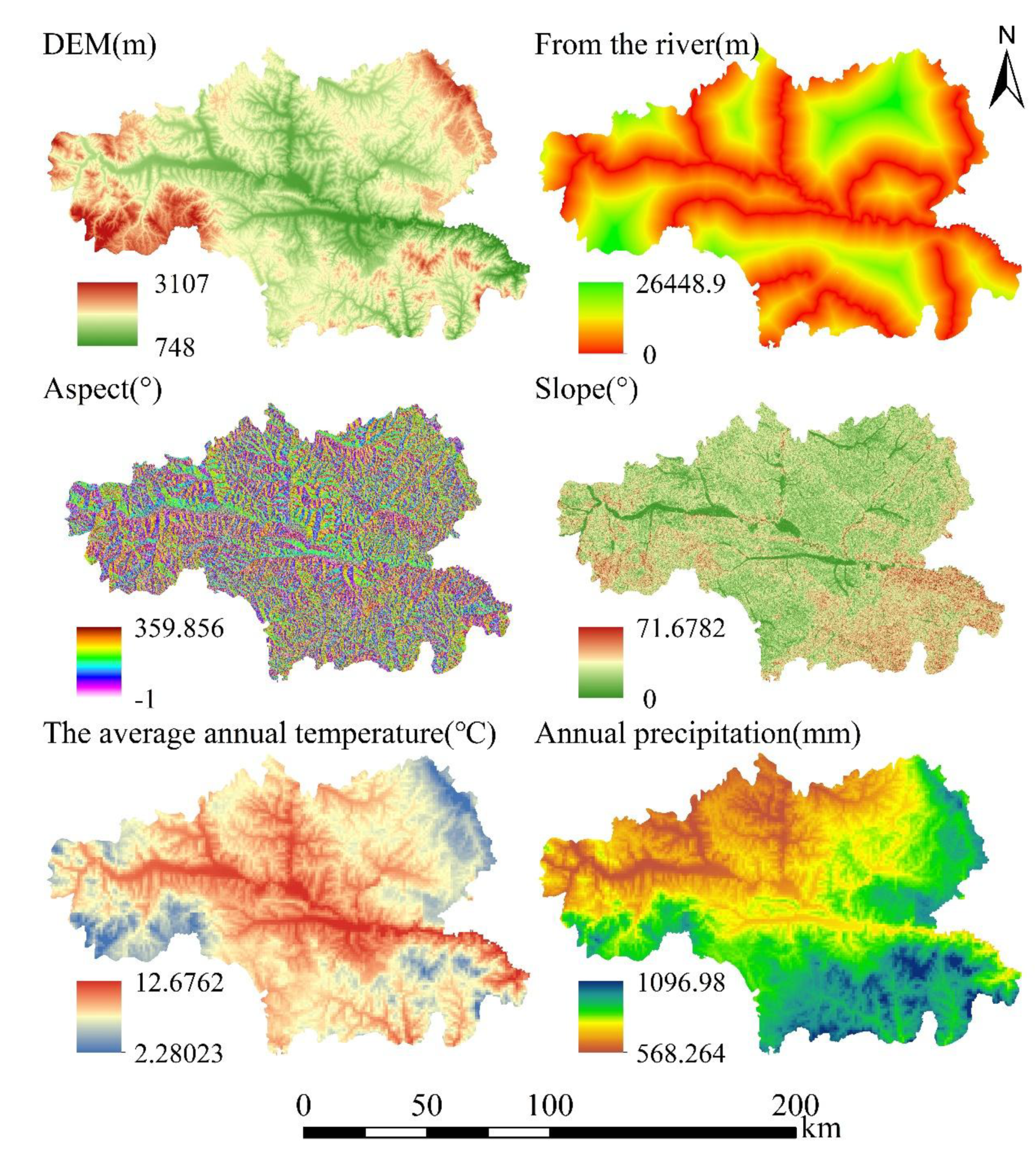
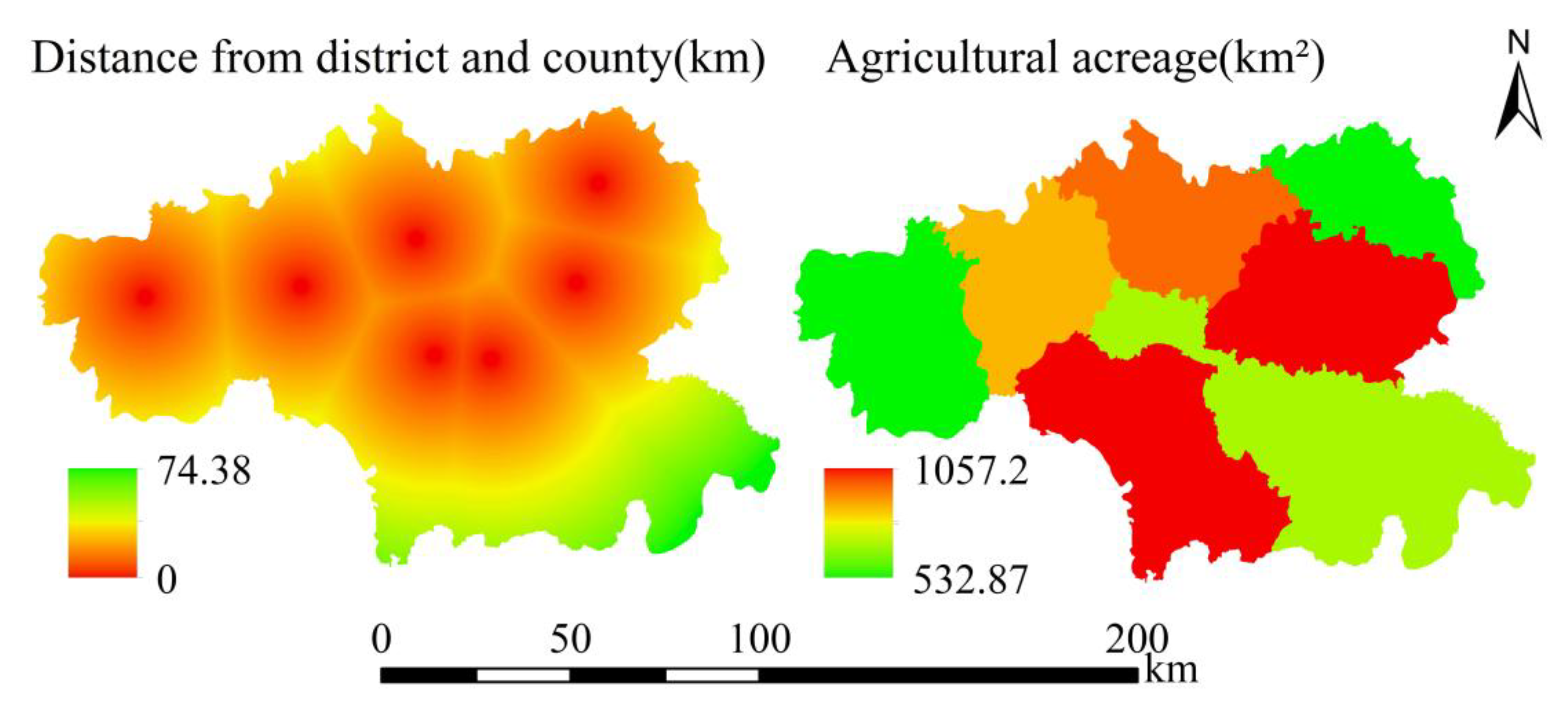
The driving factors incorporated into the model are categorized into five major groups: natural, transportation, population, economic, and social factors, encompassing a total of 20 specific elements[39]. Natural spatial factors include elevation, slope, aspect, annual average temperature, precipitation, and proximity to rivers (Figure 2). Transportation factors comprise distances to highways, railways, national roads, and local roads, including provincial and county roads (Figure 3). Population factors include total population, urban population, agricultural population, and population density (Figure 4). Economic factors encompass GDP, per capita GDP, and the gross output values of the secondary and tertiary industries (Figure 5). Social factors are represented by proximity to administrative districts and the annual cultivated land area (Figure 6).
Figure 3.
Natural spatial factors.
2.4. Ecological Risk Assessment System
In landscape ecology, the size of landscape samples should range from 2 to 5 times the average patch size to accurately capture the pattern characteristics of the surrounding landscape[40]. In Study Area 5, the average patch size of land use landscapes ranges from 0.3 to 0.4 km².To identify potential ecological risks associated with land use and optimize the structure of land use landscapes, this study constructed a relationship model between land use and ecological risk using a grid sampling method (Formula (5))[41].Based on the scope of the study area, an 800 m × 800 m square grid was employed for sampling, delineating a total of 22,960 risk zones[42].
In this formula, ERIi denotes the ecological risk index for the i-th risk zone, which is directly proportional to the level of ecological risk. Aki represents the area (km²) of land type iii within the k-th risk zone, Ak is the total area (km²) of the k-th risk zone, and Ri indicates the landscape loss index for land type i.
In the equation, Si represents the Landscape Disturbance Index, while Vi denotes the Landscape Vulnerability Index.
Figure 4.
Transportation factors.
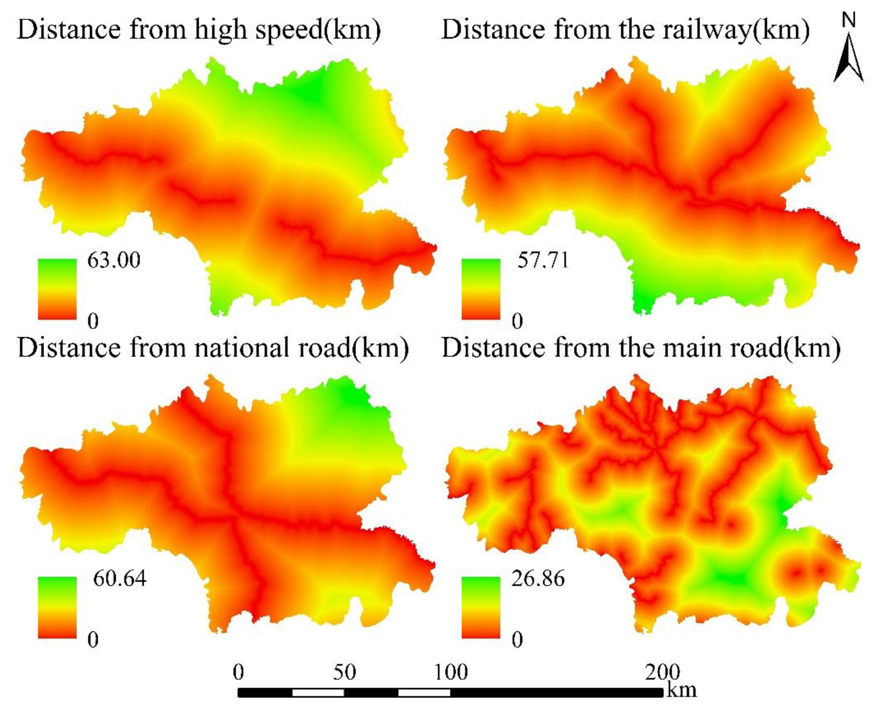
Figure 5.
Population factors.
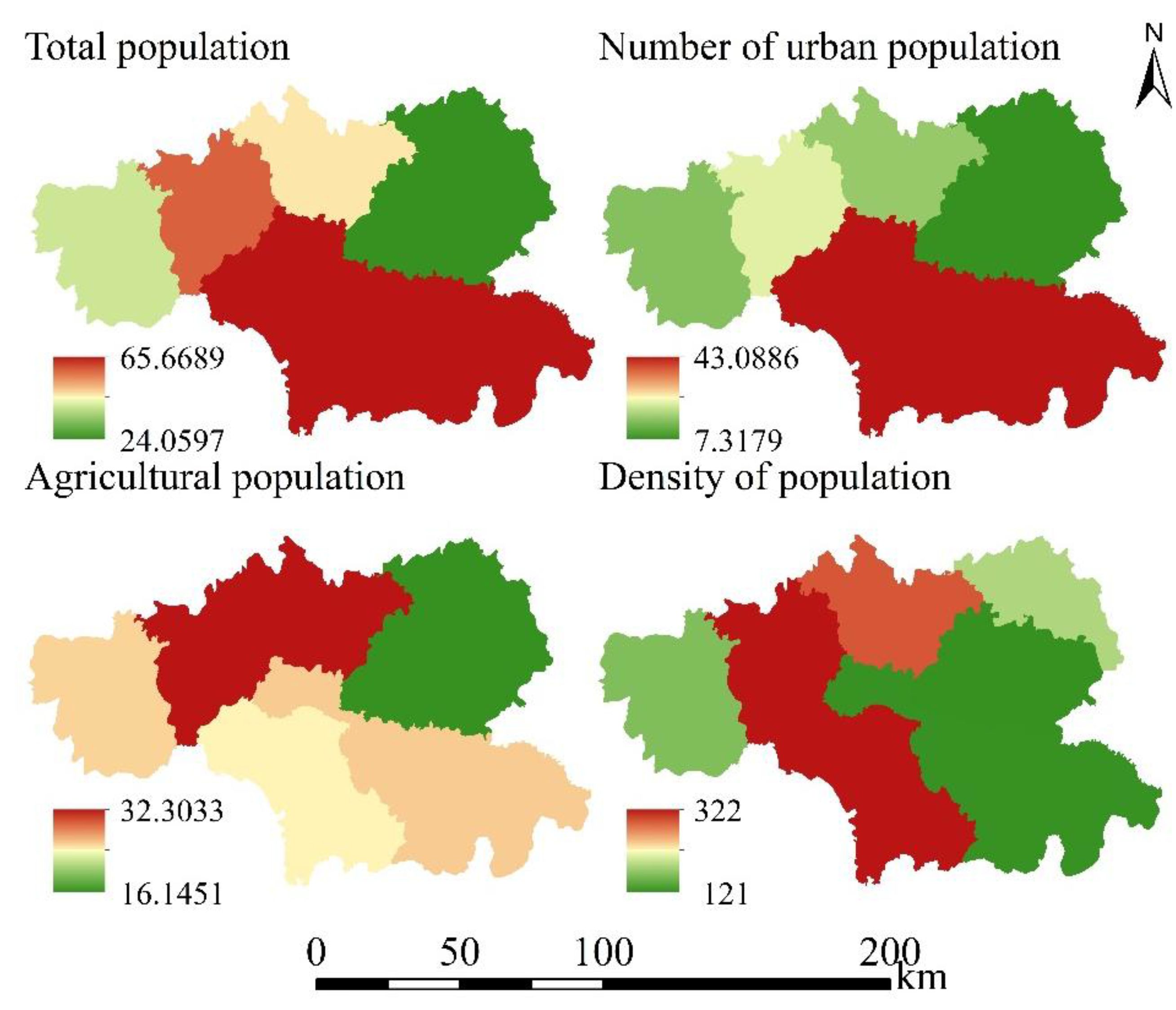
Figure 6.
Economic factors.
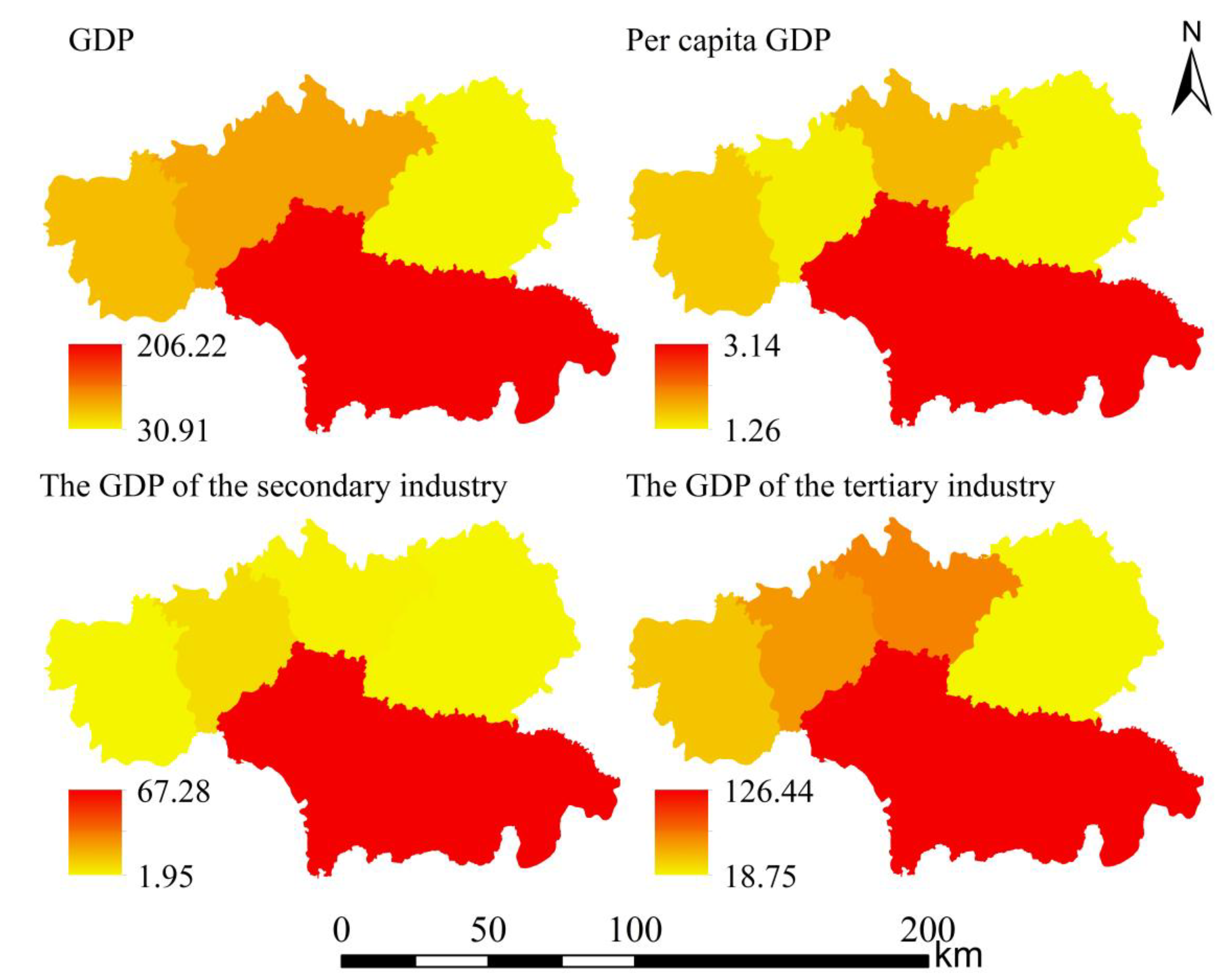
Figure 7.
Social factors.
3. Results
3.1. Spatiotemporal Dynamics of Land Use Conflicts and Their Ecological Implications
3.1.1. Spatiotemporal Dynamics and Patterns of Land Use Conflicts
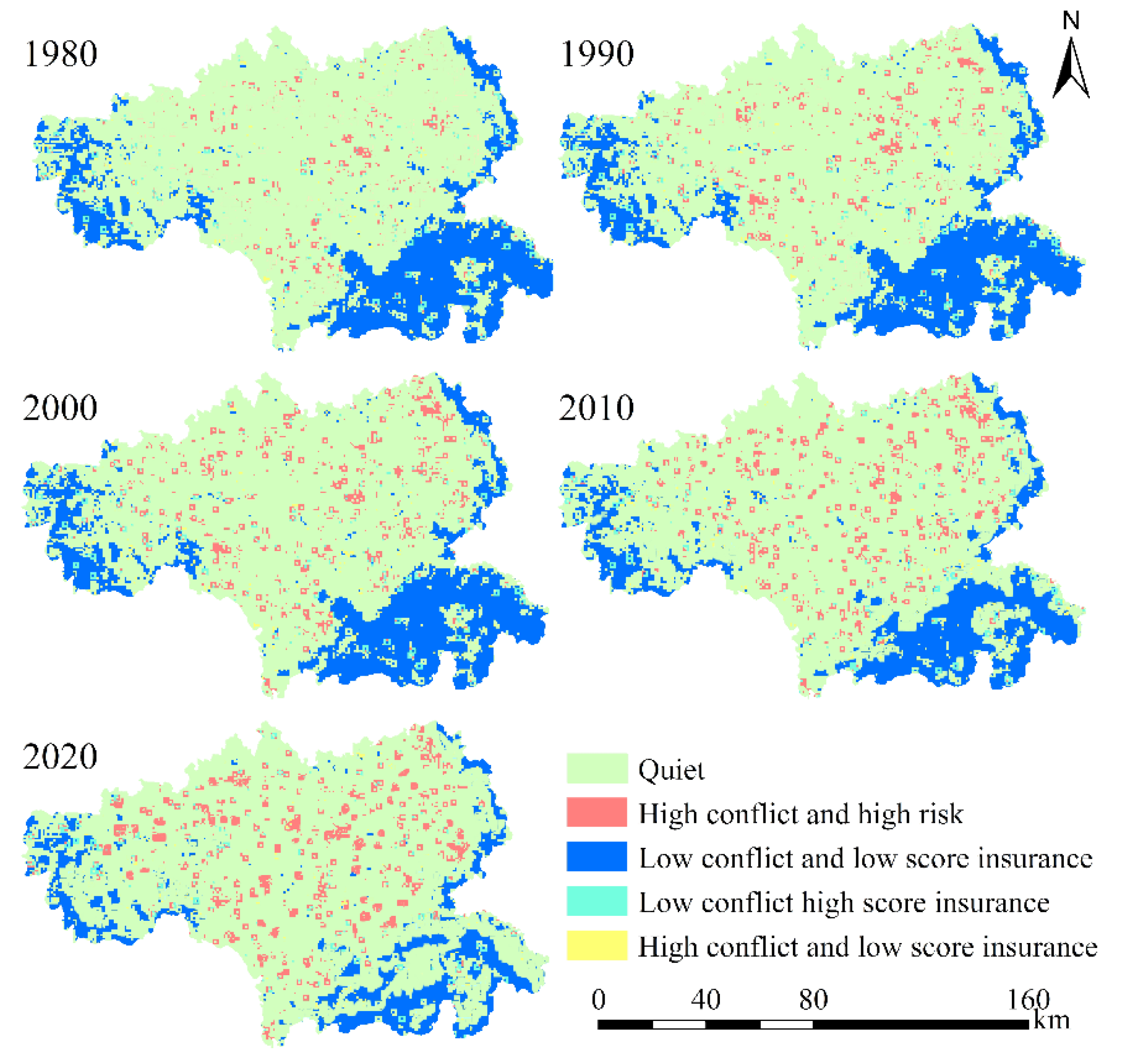
We employed ArcGIS to apply the natural breaks (Jenks) method for classifying land use conflict. This approach optimizes the partitioning of data by maximizing between-class variance and minimizing within-class variance. Based on the resulting conflict indices, we categorized land use conflict into five distinct levels: Conflict-free (0.00–0.30)、Mild conflict [0.30–0.36)、Moderate conflict[0.36–0.42)、High conflict [0.42–0.50)、Severe conflict [0.50–1.00).Given the scarcity of research on accuracy evaluation methods for land use conflict classification, this study utilizes the Kappa coefficient to evaluate both the accuracy and consistency of land use conflict classifications. The results reveal that the minimum Kappa coefficient is 0.83, which satisfies the methodological requirements of this study (Table 1).
The areas of land use conflict in Tianshui City are predominantly located in the central and northern regions (Figure 8). Between 1980 and 2020, land use conflicts in Tianshui City exhibited a notable upward trend. Specifically, the conflict-free area steadily declined from 2,705.04 km² in 1980 to 1,657.43 km² in 2020, representing a reduction of 1,047.61 km². Similarly, the area classified as having mild conflicts shrank from 726.33 km² in 1980 to 542.11 km² in 2020. Between 1980 and 2000, conflict-free and mildly conflicted areas together comprised over 54% of Tianshui City's total land area, making them the dominant conflict types during this period. In contrast, areas experiencing moderate conflicts grad-ually expanded over the four decades, increasing by approximately 21.92 km². Both high-conflict and severe-conflict areas followed similar upward trajectories, with both categories experiencing a significant overall increase during this period. Heavy-conflict areas increased significantly from 946.51 km² in 1980 to 2057.43 km² in 2020, representing the most substantial growth among all conflict types over the forty-year period. Meanwhile, high-conflict areas grew from approximately 546.51 km² in 1980 to 1,157.43 km² in 2020, nearly doubling over the period.
3.1.2. Analysis of Spatial Heterogeneity in Land Use Conflict Patterns
The analysis of land use conflict hot spots and cold spots in Tianshui City from 1980 to 2020 reveals a significant correlation between the expansion of conflict hot spots and the aggregation of high-conflict zones, particularly concentrated in the central urban and northern regions. Since 2000, the extent of these hot spot areas has further increased, extending into both central and northern parts of the city. Conversely, the reduction in cold spot areas corresponds with the decline of high-conflict aggregation zones, primarily occurring in the mountainous forest regions of southern Tianshui City. This trend can be attributed to increased homogeneity among internal land use types within cold spots, resulting in reduced patch complexity and, consequently, alleviating land use conflicts(Figure 9).
The comprehensive index of regional land use conflict, as a spatial variable, reflects both structural and stochastic spatial variations.Based on the specific conditions in Tianshui City, the dominant factors influencing the spatial differentiation of land use conflicts can be analyzed using the semivariance function in geostatistics (Table 3). When C0/(C0+C)<0.20, strong spatial autocorrelation suggests that structural factors dominate spatial heterogeneity. Conversely, C0/(C0+C)>0.70 indicates weak spatial autocorrelation,implying stochastic factors primarily influence spatial heterogeneity. Values between 0.20 and 0.70 reflect moderate spatial autocorrelation. Results show that between 1980 and 2020, C0/(C0+C) ranged from 0.2452 to 0.4657, exhibiting an increasing trend over time.This suggests that at small scales (<500 meters), natural factors like climate and topography remain the dominant drivers of spatial differentiation in land use conflict intensity within the study area.The fertile alluvial plains near the Weihe River basin in Tianshui City, with favorable hydrothermal conditions for crop growth, have historically been key areas for social and economic activities of local residents.As a result, early land use conflicts were concentrated in these regions.However, with efforts to regulate ecological protection and socio-economic development, the random variation in land use conflicts at smaller scales has continuously increased, reducing the influence of natural factors on these conflicts.

Table 2.
Fitting Model Parameters for the Variance Function of Land Use Conflict.
| Year | Fitting Model | Nugget (C0) |
Still (C0+C) |
Nugget/Still C0/C0+C |
Range(A0) | Coefficient of determinationt (R2) |
Residual RSS/10-7 |
|---|---|---|---|---|---|---|---|
| 1980 | Gauss | 0.0011 | 0.0037 | 0.2972 | 1345 | 0.8234 | 8.3421 |
| 1990 | Gauss | 0.0013 | 0.0053 | 0.2452 | 1457 | 0.8345 | 7.6421 |
| 2000 | Exponential | 0.0021 | 0.0058 | 0.3620 | 2109 | 0.9024 | 5.4534 |
| 2010 | Gauss | 0.0023 | 0.0061 | 0.3770 | 2345 | 0.9213 | 4.1758 |
| 2020 | Gauss | 0.0034 | 0.0073 | 0.4657 | 1597 | 0.8345 | 2.1896 |
3.1.3. Responses of Ecological Risks to Land Use Conflict
The bivariate LISA clustering map of land use conflicts and ecological risks reveals that arable land, identified as a high ecological risk area, exhibits a significant spatial negative correlation with non-conflict aggregation zones. This pattern is characterized by high-low clustering, which has shown a decreasing trend over time.After 2000, low-high clustering areas started to spread from the central urban region and the northern areas, with notable increases observed around construction land in Tianshui's main urban zone.By 2020, low-high clustering areas had significantly declined in the eastern and southern mountainous regions, while high-high clustering zones were sporadically distributed near low-high clusters.Furthermore, low-low clustering areas were sparsely distributed in the southern forested regions (Figure 10).
The findings reveal that ecological risks are increasingly concentrated in areas with high land use conflicts, particularly in zones of urban expansion. The shift from non-conflict to high-conflict zones has significantly heightened ecological risks, especially where arable land has been converted to urban uses. This trend is further exacerbated by the clustering of high-risk activities, such as industrial development and urban sprawl, which frequently occur at the expense of ecological preservation.
To better understand the impact of land use conflicts on ecological risks, we analyzed the relationship between land use changes and ecological risk indices. The results indicate that land use transitions—such as the conversion of forests to agricultural land or the encroachment of urban areas into natural habitats—serve as key drivers of ecological degradation. These transitions often lead to habitat fragmentation, biodiversity loss, and disruption of ecological processes, ultimately increasing the vulnerability of ecosystems to external disturbances.
Figure 10.
Bivariate LIS Clustering Analysis of Land Use Conflicts and Ecological Risk Responses.
3.2. Spatiotemporal Prediction and Simulation of Land Use Conflicts
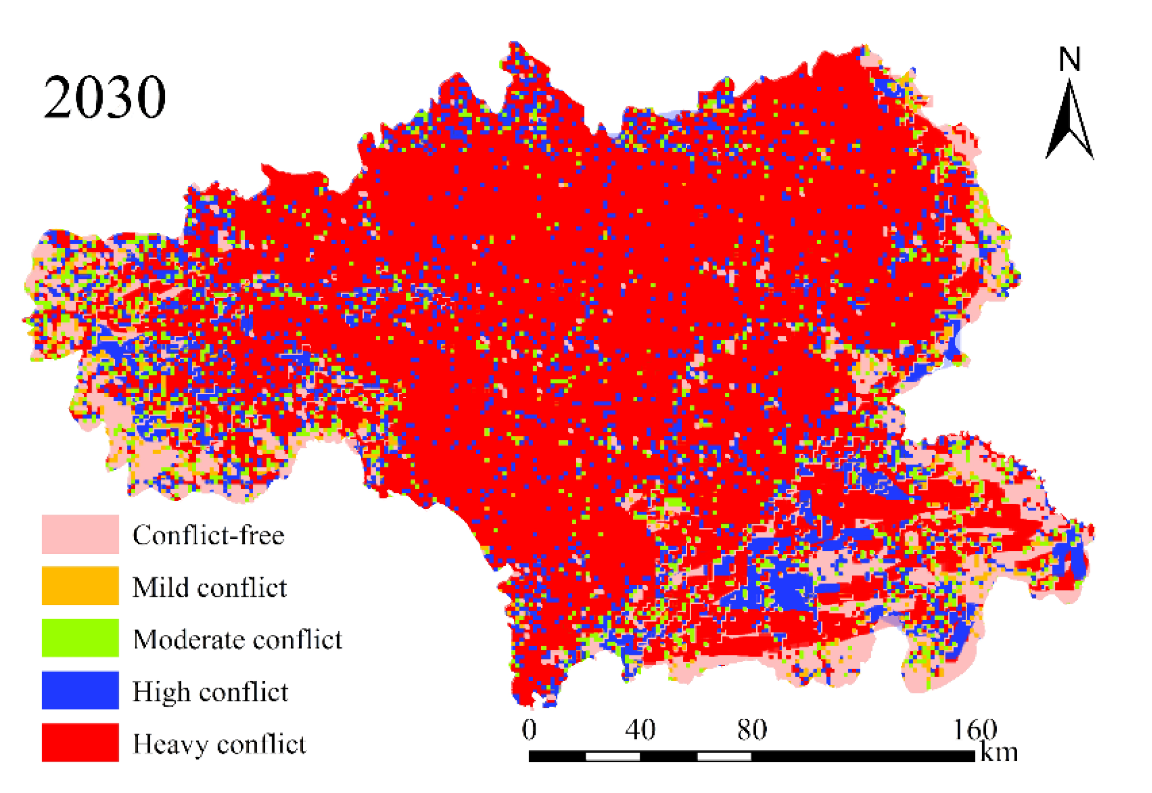
The simulation results for 2030 show that the spatial distribution of land use conflicts in Tianshui City remains broadly consistent with the pattern observed in 2020. Areas with no conflict and mild conflict still dominate the landscape, indicating some improvement in overall conditions. However, high-conflict zones have grown by 214.56 km², and severe-conflict zones have expanded by 131.97 km². This suggests that localized land use conflicts are intensifying, especially in central urban areas and northern regions, where clusters of high-conflict zones are most prominent.
Several factors contribute to this increase in high and severe-conflict zones. The rapid pace of urbanization and industrialization has heightened competition for land, intensifying conflicts in these regions. Additionally, while policies promoting ecological protection and sustainable land use have been implemented, their effectiveness has been uneven, particularly in areas where economic priorities overshadow environmental concerns. The concentration of conflict hotspots in the city center and northern areas highlights the urgent need for targeted, region-specific strategies to address these challenges. The findings also emphasize the importance of continuous monitoring and adaptive management to mitigate potential future land use conflicts.
The dynamic nature of land use conflicts is another important insight revealed by the simulation model. Changing socio-economic and environmental conditions significantly influence conflict patterns. For instance, the decline in coldspot areas, particularly in the forested mountains of southern Tianshui City, indicates evolving land use practices and shifting conflict dynamics. Policymakers and land use planners must consider these changes and develop strategies that both promote sustainable land use and address the underlying ecological risks and conflicts.
Moreover, the bivariate LISA clustering analysis highlights the close relationship between land use conflicts and ecological risks. A notable spatial negative correlation exists between arable land, a high ecological risk area, and non-conflict zones. This finding underscores the critical importance of preserving agricultural land to maintain ecological balance and reduce conflicts. Protecting farmland from conversion to other uses is essential not only for safeguarding ecological integrity but also for mitigating resource competition. Policies that support sustainable agricultural practices and prioritize farmland conservation can play a key role in reducing both ecological risks and land use conflicts in Tianshui city.
Figure 11.
Land Use Conflicts in Tianshui City by 2030.
4. Discussion
This study investigates the spatiotemporal dynamics of land use conflicts and their ecological implications in Tianshui City, focusing on identifying the underlying factors driving spatial heterogeneity and analyzing the associated ecological risks. By employing advanced analytical methods, including the natural breaks (Jenks) classification, semivariance geostatistical analysis, and bivariate LISA clustering, we systematically categorized land use conflicts and analyzed their patterns and drivers over four decades (1980–2020).
4.1. Spatiotemporal Patterns of Land Use Conflicts
The results demonstrate a clear upward trend in land use conflicts during the study period. Conflict-free areas decreased by 1,047.61 km², while mild-conflict zones shrank by 184.22 km². Conversely, high-conflict zones expanded by over 1,110.92 km², and the size of severe-conflict areas nearly doubled. These changes were particularly pronounced in urbanized and agriculturally productive regions, such as the Weihe River basin, reflecting growing pressures on land resources caused by intensified human activities. The application of the natural breaks classification method effectively delineated distinct levels of land use conflict, providing a comprehensive view of their spatial distribution and intensity across the study area[43].
The rapid expansion of severe-conflict zones is especially concerning, as these areas often experience the most significant negative impacts on both ecological systems and human well-being. The near doubling of their extent underscores an urgent need for targeted and timely measures to prevent further environmental degradation and mitigate the risk of social unrest. The concentration of these conflicts in urban centers and fertile agricultural regions highlights the intricate challenge of balancing economic growth with environmental sustainability[44].
Supporting these findings, semivariance geostatistical analysis revealed patterns of spatial autocorrelation and clustering in land use conflicts. This analysis identified clear hotspots and coldspots, offering valuable insights for policymakers to prioritize intervention strategies[45]. Hotspots, typically located in urban areas and along agricultural frontiers, are characterized by intense competition for land resources. In contrast, coldspots, usually found in more remote and less developed regions, exhibit lower levels of conflict. However, the study observed a decline in coldspot areas, particularly in the forested mountainous regions of southern Tianshui City, raising concerns about potential shifts in land use practices and conflict dynamics[46]. These changes could result in new forms of ecological degradation and social tensions, emphasizing the need for adaptive management approaches to address emerging risks effectively[47].
The bivariate LISA clustering analysis further illustrated the intricate relationship between land use conflicts and ecological risks. A significant spatial negative correlation between arable land and non-conflict zones highlights the critical importance of preserving agricultural land. Protecting these areas is not only essential for maintaining ecological stability but also for minimizing land use conflicts, as the conversion of agricultural land often intensifies resource competition and escalates conflict intensity[48].
4.2. Drivers of Spatial Heterogeneity and Temporal Dynamics
The findings indicate a temporal shift in the dominant factors influencing land use conflict patterns. Structural factors such as topography and climate initially played a major role in shaping spatial heterogeneity. However, over time, stochastic factors—including rapid urbanization and socio-economic development—emerged as the primary drivers. For example, the conversion of arable land to urban areas in regions undergoing rapid land use transitions exhibited strong spatial correlations between high land use conflicts and ecological risks[49].
Semivariance geostatistical analysis revealed significant spatial autocorrelation and variability in land use conflicts, highlighting the importance of fine-scale analysis. While topographic and climatic conditions predominantly influenced spatial heterogeneity in the early decades, stochastic factors such as policy interventions and human activities have increasingly driven conflict patterns at finer spatial scales (<500 meters). These findings align with existing studies that emphasize the growing influence of human-induced drivers on land use conflicts.
The transition from natural to anthropogenic drivers underscores the need for integrated land use planning and policy frameworks that can adapt to these changing dynamics. Policies aimed at mitigating land use conflicts must consider both the ecological and socio-economic dimensions of land use, ensuring that development is sustainable and equitable. Furthermore, the spatial and temporal analysis of land use conflicts highlights the importance of local-scale interventions tailored to specific regional contexts.
In regions experiencing rapid urbanization, for instance, policies promoting compact city development and green infrastructure can help alleviate land use pressures and reduce ecological risks. Similarly, in agriculturally fertile areas, incentives for sustainable farming practices and land conservation programs can help maintain ecological integrity and reduce conflicts over land resources.
The integration of geostatistical analysis and spatial modeling in land use planning can provide valuable insights for policymakers and planners. By identifying hotspots and coldspots of land use conflicts and ecological risks, these tools can help prioritize areas for intervention and inform the design of effective policies. Additionally, the analysis of temporal trends in land use conflict drivers can guide the development of adaptive management strategies that can evolve in response to changing conditions.
Overall, the findings of this study underscore the complexity of land use conflicts and their interactions with ecological risks. Addressing these challenges requires a multifaceted approach that integrates ecological, socio-economic, and policy dimensions. By understanding the spatial and temporal dynamics of land use conflicts, policymakers and planners can develop more effective strategies to promote sustainable land use and reduce ecological degradation.
4.3 Ecological Implications of Land Use Conflicts
The bivariate LISA clustering analysis has shed new light on the intricate relationship between land use conflicts and ecological risks. It was observed that areas with intense conflicts often coincided with zones of high ecological risk, particularly in regions undergoing rapid urban expansion. This pattern emphasizes the critical need to embed ecological risk assessments into land use planning frameworks. Urbanization in the fertile alluvial plains of the Weihe River basin in Tianshui has not only escalated conflicts but also amplified ecological degradation risks, such as habitat fragmentation and loss of biodiversity.
To address these challenges, incorporating ecological corridors and green buffer zones into urban development plans could serve as a vital strategy. Such measures would enhance ecological connectivity and simultaneously provide urban residents with green spaces for recreation, thereby improving both environmental and social well-being.
The findings also reveal that land use conflicts tend to magnify vulnerabilities in ecosystems that are already stressed. In arid and semi-arid regions, for instance, excessive groundwater extraction for agriculture has led to severe land degradation and heightened competition for water resources, further exacerbating ecological risks. Resolving these issues requires a balanced approach that harmonizes agricultural productivity with ecological sustainability. Strategies such as promoting drought-resistant crop varieties, introducing water-efficient irrigation systems, and encouraging agroforestry can play a pivotal role in mitigating these risks[50].
The implications of land use conflicts extend beyond local scales, with far-reaching effects on regional and global biodiversity. The loss of natural habitats driven by urban sprawl and intensified agricultural practices disrupts species migration, alters population dynamics, and accelerates biodiversity loss on a global scale. To counter these trends, policymakers and urban planners must take a comprehensive view of the ecological impacts of land use decisions and prioritize the conservation of critical habitats and biodiversity hotspots.
4.4. Implications for Policy and Management
The integration of ecological risk assessment into land use planning frameworks is essential for mitigating the multifaceted impacts of conflicts on ecological systems. By identifying conflict hotspots and high-risk zones, policymakers can prioritize conservation and restoration measures. For instance, promoting compact urban development alongside green infrastructure can effectively alleviate land use pressures in conflict-prone areas. Additionally, adaptive management strategies that incorporate continuous monitoring of land use patterns and emerging drivers, such as climate variability, can enhance the resilience and sustainability of land use policies.Facilitating community participation and stakeholder collaboration is critical to ensuring that land use policies address local needs and concerns. Involving local communities in decision-making provides valuable insights into ecological knowledge and social dynamics, enabling the development of culturally relevant and effective land use strategies. Moreover, policies should emphasize sustainable land use practices that minimize ecological impacts while supporting economic growth. Specific measures could include advancing sustainable agricultural technologies, encouraging renewable energy adoption, and promoting eco-tourism. Balancing ecological sustainability with economic development creates a win-win scenario that benefits both human and natural systems.Finally, recognizing the intricate relationships between land use conflicts and ecological risks across different spatial scales is crucial. This recognition necessitates coordinated efforts among various levels of government and enhanced international collaboration to address these challenges comprehensively. By sharing best practices, technological innovations, and resources, policymakers can develop innovative solutions to advance sustainable land use while safeguarding biodiversity at local and global scales.
4.5. Methodological Advancements and Future Directions
This study extends existing research by integrating geostatistical techniques with LISA clustering to provide a comprehensive analysis of the spatial and temporal dynamics of land use conflicts and ecological risks. The approach allows for the identification of hotspots and coldspots of conflicts, offering actionable insights for targeted interventions. Future research should expand this methodology to incorporate higher-resolution datasets, multi-variate statistical models, and machine learning techniques to capture complex interactions and feedback loops. Cross-regional comparative studies are also recommended to validate and generalize these findings.
Furthermore, integrating remote sensing and GIS technologies can enhance the precision and timeliness of ecological risk assessments. These technologies provide valuable data on land cover changes, vegetation health, and soil moisture, which are crucial for understanding and predicting ecological vulnerabilities. By leveraging these advancements, future studies can achieve a more nuanced understanding of land use conflicts and their ecological impacts, paving the way for more effective and targeted conservation measures. Additionally, incorporating socio-economic data into ecological risk assessments can provide a more holistic view of the complex interactions between human activities and ecological systems. This approach can help identify the root causes of land use conflicts and inform policies that address both ecological and social dimensions of sustainability.
5. Conclusion
This research investigates the spatiotemporal dynamics of land use conflicts in Tianshui City, emphasizing their intensification due to urbanization and socio-economic transformations, as well as the associated ecological consequences. The findings indicate that the expansion of high-conflict zones, particularly in urbanized and agriculturally fertile areas, is closely linked to escalating ecological risks, such as habitat fragmentation and biodiversity loss. By employing geostatistical techniques and LISA clustering analysis, critical conflict hotspots and ecological risk areas were identified, offering practical guidance for sustainable land use planning. It is recommended that policymakers prioritize the management of these hotspots, advocate for sustainable practices, and incorporate ecological assessments into planning frameworks to mitigate land use conflicts and strengthen ecological resilience.
Author Contributions
The research design was completed by Q.L. The manuscript was written by Q.L. The collection and analysis of samples were performed by Y.L.
Funding
This research was supported by the 2024 Projects for Philosophical and Social Sciences Research in Gansu Province (No.2024gansu15) and the Gansu Provincial University Teachers Innovation Fund (Project No. 2025B-158).
Institutional Review Board Statement
Not applicable.
Informed Consent Statement
Not applicable.
Data Availability Statement
Data will be made available upon reasonable request through the corresponding author.
Acknowledgments
Many thanks to Yuan Gao for their technical assistance in the labora tory work. We would like to thank Pei Ge and Ruixi Liu for providing statistics assistance.
Conflicts of Interest
The authors declare no conflicts of interest.
References
- Wang, D.; Wang, M.; Zheng, W.; Song, Y.; Huang, X. A multi-level spatial assessment framework for identifying land use conflict zones. Land Use Policy 2025, 148. [Google Scholar] [CrossRef]
- Zong, S.; Xu, S.; Huang, J.; Ren, Y.; Song, C. Distribution patterns and driving mechanisms of land use spatial conflicts: Empirical analysis from counties in China. Habitat Int 2025, 156. [Google Scholar] [CrossRef]
- Sanchez, L.M.S.; Schilling, J.; Bossenbroek, L.; Ezzayyat, R.; Berger, E. Drivers of conflict over customary land in the Middle Draa Valley of Morocco. World Dev 2025, 188. [Google Scholar]
- Su, R.; Song, G.; Wang, Q. Identification and Driving Effects of Land Use Conflicts in Mega-City in Northeast China: A Case Study of Shenyang City. Pol J Environ Stud 2025, 34. [Google Scholar] [CrossRef] [PubMed]
- Amare, M.; Abay, K.A.; Berhane, G.; Andam, K.S.; Adeyanju, D. Conflicts, crop choice, and agricultural investments: Empirical evidence from Nigeria. Land Use Policy 2025, 148. [Google Scholar] [CrossRef]
- Bullock, R.; Lamoureux, B. Understanding "public" framings of private places and psychological ownership in a rural land use conflict. J Rural Stud 2025, 114. [Google Scholar] [CrossRef]
- Zhu, L.; Wang, C.; Sun, W.; Xing, H.; Feng, C.; Su, Q. Impact of civil war on the land cover in Myanmar. Environ Monit Assess 2025, 197. [Google Scholar] [CrossRef]
- Liu, Y.; Xu, R.; Yang, J.; Xie, X.; Cui, X. Decoding Land Use Conflicts: Spatiotemporal Analysis and Constraint Diagnosis from the Perspectives of Production-Living-Ecological Functions. Land-Basel, 2024; 13. [Google Scholar]
- Wang, G.; Wang, J.; Wang, L.; Zhang, Y.; Zhang, W. Land-Use Conflict Dynamics, Patterns, and Drivers under Rapid Urbanization. Land-Basel, 2024; 13. [Google Scholar]
- Zheng, W.; Guo, B.; Su, H.; Liu, Z. Study on multi-scenarios regulating strategy of land use conflict in urban agglomerations under the perspective of "three-zone space": a case study of Harbin-Changchun urban agglomerations, China. Front Env Sci-Switz, 2024; 11. [Google Scholar]
- Xiao, J.; Dai, J.; Chen, L.; Song, Y. The Identification of Land Use Conflicts and Policy Implications for Donghai County Based on the "Production-Living-Ecological" Functions. Land-Basel, 2024; 13. [Google Scholar]
- Wu, G.; Lin, Y.; Zhao, J.; Chen, Q. Identification of Land Use Conflict Based on Multi-Scenario Simulation-Taking the Central Yunnan Urban Agglomeration as an Example. Sustainability-Basel, 2024; 16. [Google Scholar]
- Liao, W.; Hu, X.; Huang, Z.; Wei, M. Identifying the Optimal Scenario for Reducing Land-Use Conflicts in Regional Development. Land-Basel, 2024; 13. [Google Scholar]
- Ma, W.; Li, H.; Lei, S.; Tong, Z.; Wang, N. A novelty modeling approach to eliminate spatial conflicts and ecological barriers in mining areas of a resource-based city. Ecol Indic 2024, 169. [Google Scholar] [CrossRef]
- Zhang, B.; Zhai, J.; Zhai, B.; Qu, Y. Understanding the "conflict-coordination" theoretical model of regional land use transitions: Empirical evidence from the interconversion between cropland and rural settlements in the lower yellow river, China. Habitat Int 2024, 148. [Google Scholar] [CrossRef]
- Dong, G.; Sun, Z.; Li, W.; Wang, K.; Yuan, C. Identification of Potential Land Use Conflicts in Shandong Province: A New Framework. Land-Basel, 2024; 13. [Google Scholar]
- Li, W.; Kang, J.; Wang, Y. Land Use Conflicts Identification and Multi-Scenario Simulation in Mountain Cities, Southwest China: A Coupled Structural and Functional Perspective. Land Degrad Dev 2024. [Google Scholar] [CrossRef]
- Cao, J.; Cao, W.; Cao, Y.; Wang, X.; Zhang, Y.; Ma, J. Multi-scenario land use prediction and layout optimization in Nanjing Metropolitan Area based on the PLUS model. J Geogr Sci 2024, 34, 1415–1436. [Google Scholar] [CrossRef]
- Chen, L.; Zhang, A. Identification of land use conflicts and dynamic response analysis of Natural-Social factors in rapidly urbanizing areas- a case study of urban agglomeration in the middle reaches of Yangtze River. Ecol Indic 2024, 161. [Google Scholar] [CrossRef]
- He, Q.; Cai, H.; Chen, L. Concept and Method of Land Use Conflict Identification and Territorial Spatial Zoning Control. Sustainability-Basel, 2024; 16. [Google Scholar]
- Zong, S.; Xu, S.; Jiang, X.; Song, C. Identification and dynamic evolution of land use conflict potentials in China, 2000-2020. Ecol Indic 2024, 166. [Google Scholar] [CrossRef]
- Wu, J.; Wang, C.; He, X.; Zhou, C.; Wang, H. Nonlinear Effects of Land-Use Conflicts in Xinjiang: Critical Thresholds and Implications for Optimal Zoning. Land-Basel, 2024; 13. [Google Scholar]
- Fernandes-Tavares, T.; Blanco, J.L.Y.; Pascual, C. Dispossessed lands and land-use change in the Colombian armed conflict: Exploring a link through a regional case study. J Rural Stud 2024, 108. [Google Scholar] [CrossRef]
- Chang, S.; Wei, Y.; Dai, Z.; Xu, W.; Wang, X.; Duan, J.; Zou, L.; Zhao, G.; Ren, X.; Feng, Y. Landscape ecological risk assessment and its driving factors in the Weihe River basin, China. J Arid Land 2024, 16, 603–614. [Google Scholar] [CrossRef]
- Tseer, T.; Salifu, K.; Yiridomoh, G.Y. Land use practices and farmer-herder conflict in Agogo: dynamics of traditional authority and resistance. Third World Q 2024, 45, 1238–1255. [Google Scholar] [CrossRef]
- Ugwu, E.U.; Akase, T.M. Out of Frame: Invisibilisation of Non-Human Nature in Media Framing of a Land Conflict Transformation Policy in Nigeria. Afr Journal Stud 2024. [Google Scholar] [CrossRef]
- Mudapakati, C.P.; Bandauko, E.; Chaeruka, J.; Arku, G. Peri-urbanisation and land conflicts in Domboshava, Zimbabwe. Land Use Policy 2024, 144. [Google Scholar] [CrossRef]
- Afrizal; Putra, E. V.; Elida, L. Palm oil expansion, insecure land rights, and land-use conflict: A case of palm oil centre of Riau, Indonesia. Land Use Policy 2024; Volume 146. [Google Scholar]
- Lu, Q.; Sun, J.; Xiao, Y.; Zhu, S.; Zhu, G.; Liu, J.; Li, X.; Liu, H. The progression traits of spatial conflicts within the production-living-ecological space among varying geomorphological types of mountain-basin areas in karst regions, China. Ecol Indic 2024, 166. [Google Scholar] [CrossRef]
- Furumo, P.R.; Yu, J.; Hogan, J.A.; Tavares De Carvalho, L.M.; Brito, B.; Lambin, E.F. Land conflicts from overlapping claims in Brazil's rural environmental registry. P Natl Acad Sci Usa 2024, 121, e1887610175. [Google Scholar] [CrossRef]
- Richetta, C.; Wegenast, T. Access denied: Land alienation and pastoral conflicts. J Peace Res 2024. [Google Scholar] [CrossRef]
- Tessema, A.M.; Amsalu, T.B.; Dadi, T.T. Communal Grazing Land Distribution and Land Use Conflict in East Gojjam Zone: Insight From Baso Liben District, North-Western Ethiopia. J Asian Afr Stud 2024. [Google Scholar] [CrossRef]
- Eklund, L.; Mohr, B.; Dinc, P. Cropland abandonment in the context of drought, economic restructuring, and migration in northeast Syria. Environ Res Lett 2024, 19. [Google Scholar] [CrossRef]
- Steward, R.; Chopin, P.; Verburg, P.H. Supporting spatial planning with a novel method based on participatory Bayesian networks: An application in Curaçao. Environ Sci Policy 2024, 156. [Google Scholar] [CrossRef]
- Zhou, D.; Zhao, X.; Li, P.; Jin, F.; Li, S.; Li, H.; Wang, J. Assessing territorial space conflicts in the coastal zone of Wenzhou, China: A land-sea interaction perspective. Sci Total Environ 2024, 926. [Google Scholar] [CrossRef]
- Gurmessa, M.M.; Moisa, M.B.; Tesso, G.J.; Erena, M.G. Impacts of land use land cover change on Leopard (Panthera pardus) habitat suitability and its effects on human wildlife conflict in Hirkiso forest, Sibu Sire District, Western Ethiopia. All Earth 2024, 36, 1–24. [Google Scholar] [CrossRef]
- Zhu, Z.; Peng, S.; Ma, X.; Lin, Z.; Ma, D.; Shi, S.; Gong, L.; Huang, B. Identification of potential conflicts in the production-living-ecological spaces of the Central Yunnan Urban Agglomeration from a multi-scale perspective. Ecol Indic 2024, 165. [Google Scholar] [CrossRef]
- Ahmed, A.; Rotich, B.; Czimber, K. Assessment of the environmental impacts of conflict-driven Internally Displaced Persons: A sentinel-2 satellite based analysis of land use/cover changes in the Kas locality, Darfur, Sudan. Plos One 2024, 19. [Google Scholar] [CrossRef]
- Yang, R.; Chen, S.; Dong, X.; Wang, K.; He, T.; Chen, H.; Li, X.; Ye, Y.; Xiao, W. Revealing conflict risk between landscape modification and species conservation in the context of climate change. J Clean Prod 2024, 479. [Google Scholar] [CrossRef]
- Huang, X.; Wu, Z.; Zhu, L.; Li, Y. Accurate identification and trade-off analysis of multifunctional spaces of land in megacities: A case study of Guangzhou city, China. Habitat Int 2024, 153. [Google Scholar] [CrossRef]
- Wang, C.; Wu, J.; Li, M.; Huang, X.; Lei, C.; Wang, H. Evaluation of spatial conflicts of land use and its driving factors in arid and semiarid regions: A case study of Xinjiang, China. Ecol Indic 2024, 166. [Google Scholar] [CrossRef]
- Li, W.; Kang, J.; Wang, Y. Exploring the Coupling Relationship and Driving Factors of Land Use Conflicts and Ecosystem Services Supply-Demand Balances in Different Main Functional Areas, Southwest China. Land Degrad Dev 2024, 35, 5237–5253. [Google Scholar] [CrossRef]
- Basheer, M.; Elagib, N.A. Armed conflict as a catalyst for increasing flood risk. Environ Res Lett 2024, 19. [Google Scholar] [CrossRef]
- Kiesecker, J.M.; Evans, J.S.; Oakleaf, J.R.; Dropuljic, K.Z.; Vejnovic, I.; Rosslowe, C.; Cremona, E.; Bhattacharjee, A.L.; Nagaraju, S.K.; Ortiz, A.; et al. Land use and Europe's renewable energy transition: identifying low-conflict areas for wind and solar development. Front Env Sci-Switz, 2024; 12. [Google Scholar]
- Wilhelm, E.H. Settlement growth and military conflict in early colonial New England 1620-1700. Eur J Law Econ 2024, 57, 435–464. [Google Scholar] [CrossRef]
- Sutiyo, S. The struggle for land by indigenous groups: from conflict to cooperation in Kasepuhan Ciptagelar, Indonesia. Community Dev J 2024. [Google Scholar] [CrossRef]
- Syaban, A.S.N.; Appiah-Opoku, S. Unveiling the Complexities of Land Use Transition in Indonesia's New Capital City IKN Nusantara: A Multidimensional Conflict Analysis. Land-Basel, 2024; 13. [Google Scholar]
- Zhou, H.; Tang, M.; Huang, J.; Mei, X.; Zhao, H. Driving mechanisms and multi-scenario simulation of land use change based on National Land Survey Data: a case in Jianghan Plain, China. Front Env Sci-Switz, 2024; 12. [Google Scholar]
- Xiong, S.; Yang, F.; Zhang, J.; Tang, Y. An integrated model chain for diagnosing and predicting conflicts between production-living-ecological space in lake network regions: A case of the Dongting Lake region, China. Ecol Indic 2024, 166. [Google Scholar] [CrossRef]
- Anderson, R.M.; Charnley, S.; Martin, J.V.; Epstein, K. Large, rugged and remote: The challenge of wolf-livestock coexistence on federal lands in the American West. People Nat 2024. [Google Scholar] [CrossRef]
Figure 2.
Research design.
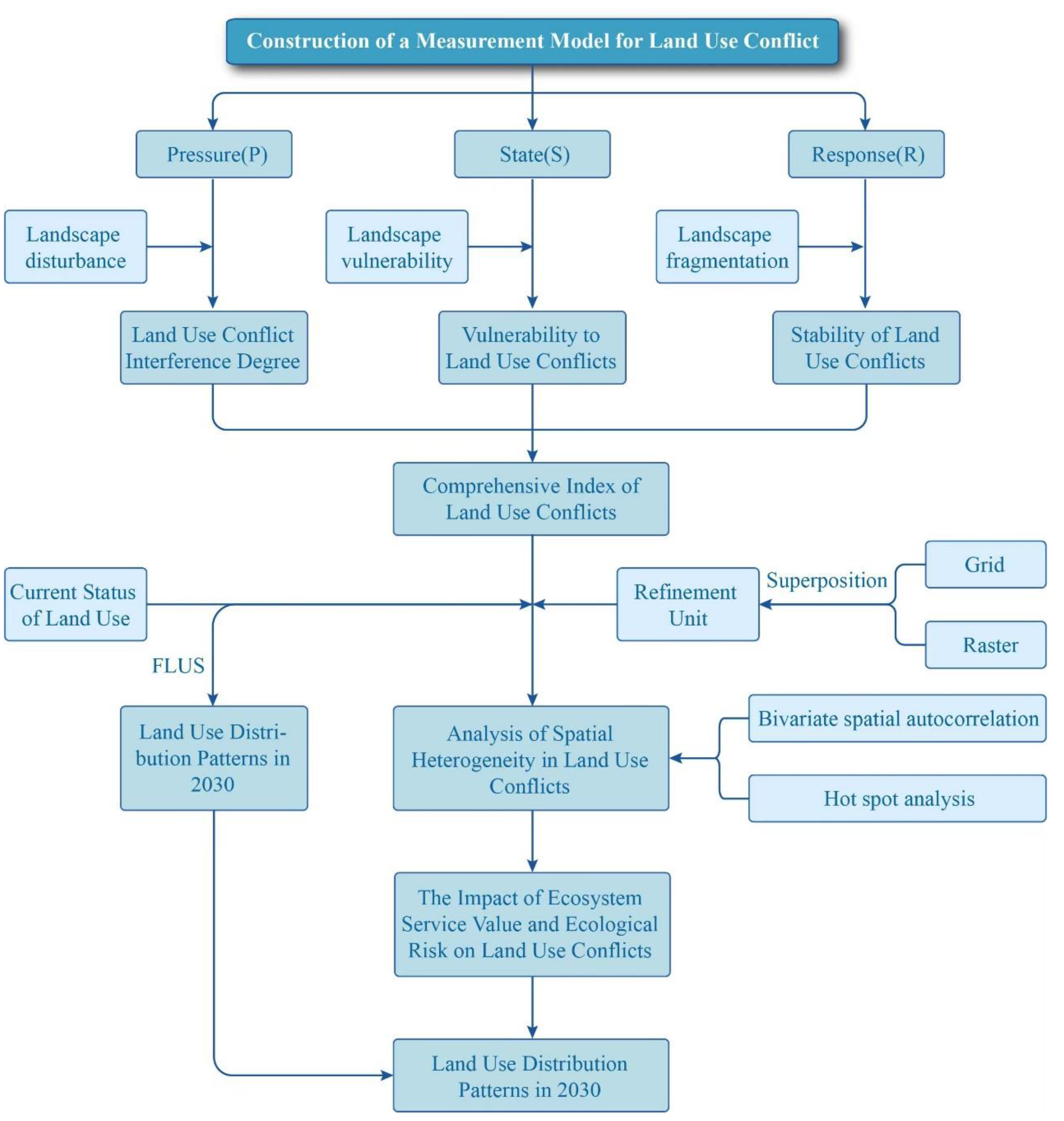
Figure 8.
Patterns of Land Use Conflict Distribution Levels.
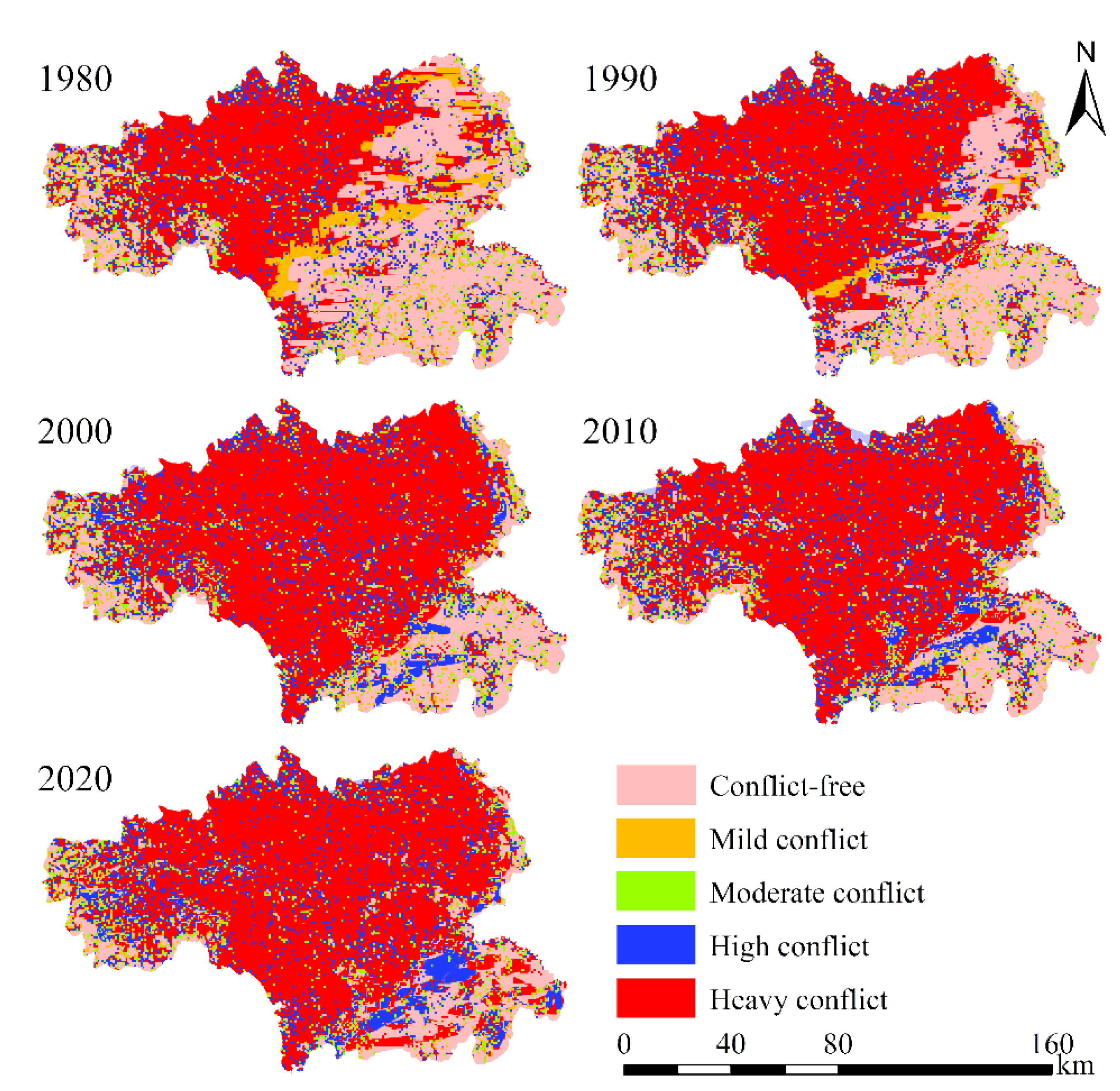
Figure 9.
Spatiotemporal Prediction and Simulation of Land Use Conflicts.
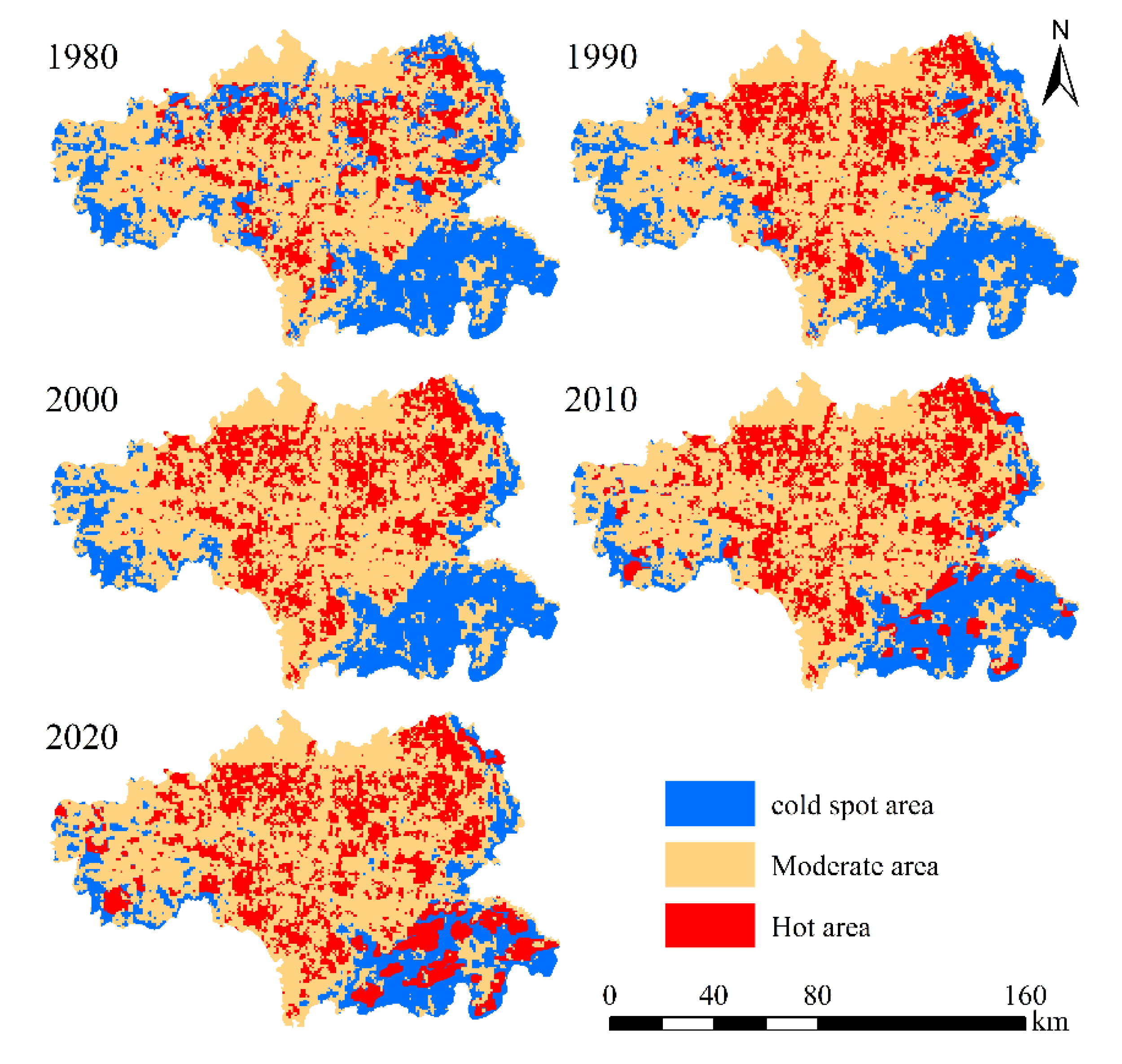
Table 1.
Land Use Conflict Classification Kappa Coefficient.
| Year | Conflict-free | Mild conflict | Moderate conflict | High conflict | Heavy confict |
|---|---|---|---|---|---|
| 1980 | 0.85 | 0.88 | 0.87 | 0.86 | 0.91 |
| 1990 | 0.91 | 0.87 | 0.96 | 0.85 | 0.85 |
| 2000 | 0.88 | 0.90 | 0.84 | 0.96 | 0.86 |
| 2010 | 0.85 | 0.92 | 0.88 | 0.88 | 0.89 |
| 2020 | 0.92 | 0.85 | 0.86 | 0.87 | 0.87 |
Disclaimer/Publisher’s Note: The statements, opinions and data contained in all publications are solely those of the individual author(s) and contributor(s) and not of MDPI and/or the editor(s). MDPI and/or the editor(s) disclaim responsibility for any injury to people or property resulting from any ideas, methods, instructions or products referred to in the content. |
© 2025 by the author. Licensee MDPI, Basel, Switzerland. This article is an open access article distributed under the terms and conditions of the Creative Commons Attribution (CC BY) license (https://creativecommons.org/licenses/by/4.0/).
Copyright: This open access article is published under a Creative Commons CC BY 4.0 license, which permit the free download, distribution, and reuse, provided that the author and preprint are cited in any reuse.


